interpretative report on a ground investigation for
TRANSCRIPT

INTERPRETATIVE REPORT
on
A GROUND INVESTIGATION
for
BUTLERS HILL INFANTS/BROOMHILL JUNIOR SCHOOL,
HUCKNALL,
NOTTINGHAMSHIRE
FAITHFUL+GOULD
BROADGATE HOUSE
BROADGATE
BEESTON
NOTTINGHAM
NG9 2HF
REPORT NO: G15039-H-IR APRIL 2015

Butlers hill Infants/Broomhill Junior School, Hucknall, Nottinghamshire - Ground Investigation Report
Nicholls Colton Geotechnical Report No: G4039-H-IR
April 2015 Status: Final
CONTENTS
SECTION TITLE PAGE NO.
Factual Information
1. Introduction 1
2. Site Description 1
3. Geological Review 2
4. Site Work 2
5. In Situ Testing 2
6. Laboratory Testing 3
7. General Geology and Revealed Strata 4
8. Groundwater 4
Assessment and Recommendations
9. Proposed Works 5
10. Soil Profile 5
11. Excavations 6
12. Foundations 7
13. Ground Floor Slabs 7
14. Concrete Classification 7
15. Drainage 8
16. Hardstanding 8
17. Soil Contamination 8
18. Summary and Conclusions 10
Appendix
A. Window Sample Borehole Logs
B. Falling Head Test Results
C. Laboratory Test Results – Geotechnical
D. Laboratory Test Results – Soil Contamination
Drawings
G15039-H-IR/01 Site Location Plan
G15039-H-IR/02 Exploratory Hole Location Plan

Butlers Hill Infants/Broomhill Junior School, Hucknall, Nottinghamshire - Ground Investigation Report
Nicholls Colton Geotechnical 1 of 10 Report No: G15039-H-IR
April 2015 Status: Final
INTERPRETATIVE REPORT ON A GROUND INVESTIGATION FOR PROPOSED NEW CLASSROOM BLOCKS AT
BUTLERS HILL INFANTS/BROOMHILL JUNIOR SCHOOL, HUCKNALL, NOTTINGHAMSHIRE
Factual Information
1. Introduction
1.1 This report has been prepared on instructions given by Faithful+Gould, Broadgate House,
Broadgate, Beeston, Nottingham, NG9 2HF.
1.2 It is understood that it is proposed to install two modular classroom units and construct an area of
car parking in an existing playground area. Associated landscaping, drainage and utility works will
be required.
1.3 The purpose of this investigation was to obtain preliminary data regarding ground and
groundwater conditions at the site, so that suitable methods of design and construction may be
adopted for the proposed development.
1.4 No desk study has been undertaken as part of this report, such work is outside of the scope of this
investigation. The scope of works has been provided by the client.
1.5 The school is located some 5km north west of Nottingham city centre in Hucknall and is situated
adjacent to a residential area with access from Broomhill Road (National Grid Reference SK 54024
48235). The location of the site is shown on the appended site location plan (Nicholls Colton
Geotechnical drawing no. G15039-H-IR/01).
1.6 This report has been prepared on the specific instructions of Faithful+Gould and Nottinghamshire
County Council and no reliance should be made by third parties as to its adequacy or
completeness in relation to future development requirements of the area under consideration.
Similarly, Nicholls Colton Geotechnical (and Nicholls Colton Group Ltd) will accept no liability in
relation to the use of data contained in this report by third parties.
2. Site Description
2.1 A site walkover was undertaken by a Geotechnical Engineer at the time of the fieldwork and the
salient observations are noted below:
• The combined campus grounds amalgamate Butlers Hill primary & infant’s school, Broomhill
junior’s school and a Sure Start nursery. Three separate areas were investigated:-
� A new F2 classroom block is proposed in area of soft landscaping located to the east
of the playground within the grounds of Butlers Hill primary & infants school. The
topography is flat and the area is surfaced with turf interspersed with trees and
shrubs.
� The playground at the rear of Broomhill Juniors school is a flat area surfaced in
bituminous macadam it is the proposed location for a new car park.

Butlers Hill Infants/Broomhill Junior School, Hucknall, Nottinghamshire - Ground Investigation Report
Nicholls Colton Geotechnical 2 of 10 Report No: G15039-H-IR
April 2015 Status: Final
� A new KS2 classroom block is proposed in an area at the north west corner of the
Broomhill Juniors playing field adjacent to the Astro turf pitch. There is a slight fall in
ground level at the edge of the playing field. There are several mature deciduous
trees at the north western end of the area. A Sewer is likely to traverse the footprint
of the new building.
• No sources of potential contamination were noted within any of the areas proposed for
development.
3. Geological Review
3.1 The site is located in an area where the British Geological Survey (BGS) indicate the bedrock
geology to comprise the Edlington Formation (mudstone and sandstone with subordinate
siltstone) of the Permian period. No superficial deposits are anticipated to be present beneath the
site.
3.2 The property lies in an area recognised for the higher probability of radon and on this basis basic
radon protection measures are likely to be required. This aspect should be confirmed with the
Local Authority Building Control.
3.3 Coal bearing strata are anticipated to underlie the site at depth. No assessment of the potential
for mineworkings has been undertaken as part of this investigation, such work is outside of the
scope of this report.
4. Site Work
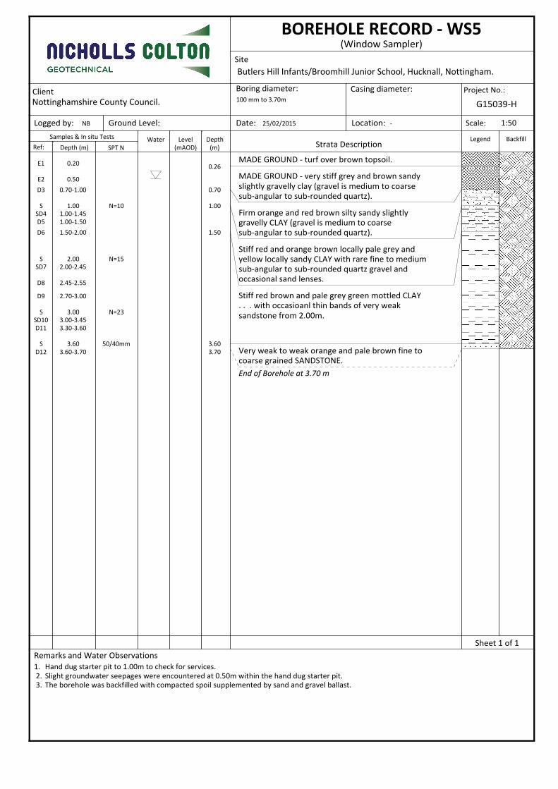
4.1 Five window sample boreholes (WS1 to WS5 inclusive) were put down to depths ranging from
2.30m (WS4) to 3.70m (WS5) below existing ground level, to provide information for the
proposed works.
4.2 The window sample borehole logs are included in this report as Appendix A.
4.3 The positions of the exploratory holes were determined by the client and set out by Nicholls
Colton Geotechnical taking into account the available access and services. The positions of the
boreholes are shown on the appended exploratory hole location plan (Nicholls Colton
Geotechnical drawing no. G15039-H-IR/02).
4.4 Fragmentary disturbed samples were recovered from all materials revealed within the window
sample boreholes. Geo-environmental samples were obtained specifically for contamination
testing.
4.5 The samples were taken to Nicholls Colton Analytical’s laboratory for further examination and
testing.
4.6 The fieldwork was carried out on 25th
February 2015.
4.7 Fieldwork was generally carried out in accordance with BS5930 (1999) “Codes of Practice for Site
Investigations”, logged in accordance with BS EN ISO 14688-1:2004 and BS EN ISO 14688-2: 2004
and the work overseen by an experienced Geotechnical Engineer.

Butlers Hill Infants/Broomhill Junior School, Hucknall, Nottinghamshire - Ground Investigation Report
Nicholls Colton Geotechnical 3 of 10 Report No: G15039-H-IR
April 2015 Status: Final
5. In Situ Testing
5.1 Standard Penetration Tests (SPT’s) were carried out using the split spoon (S) attachment within
the boreholes. The tests were carried out in accordance with BS EN ISO 22476-3:2005. The results
are included on the appended borehole logs (Appendix A). The calibration / efficiency certificate
for the rig is also attached.
5.2 A falling head permeability test was undertaken within borehole WS1 to assess the suitability of
the soils at the site for the adoption of soakaway drainage. The results of the falling head test are
included in this report as Appendix B.
6. Laboratory Testing
6.1 The laboratory testing schedules were prepared by Nicholls Colton Geotechnical.
6.2 Included in this report is information taken from the results of tests undertaken in Nicholls Colton
Analytical laboratory at 7-11 Harding Street, Leicester. This is UKAS accredited testing laboratory
No. 0320. The results of the laboratory tests in this report do not include all data required by the
documented test procedure. However, all such data has been recorded and will be stored for six
years from the date of test. This data will be issued on the client’s instructions.
The following accredited test procedures were carried out:
• Plastic Limit
• Liquid Limit
• Plasticity Index
• Natural Moisture Content
Opinions and interpretations expressed herein are outside the scope of UKAS accreditation.
6.3 The geotechnical laboratory testing has been carried out in accordance with BS 1377: 1990 using
calibrated equipment specified within the British Standard.
6.4 The geotechnical laboratory tests were carried out during the period 9th
to 18th
March 2015.
6.5 The geotechnical laboratory test results are included in this report as Appendix C.
6.6 In addition to the geotechnical laboratory testing, laboratory testing of five soil samples was
undertaken by Nicholls Colton Analytical’s laboratory, in accordance with MCERTS accreditation
standards. The samples were analysed for the following determinands:-
(all values ‘total’ unless otherwise stated)
• Arsenic • Mercury
• Asbestos (presence of) • Nickel
• Cadmium • Phenols
• Chromium • pH Value
• Copper • Speciated Polyaromatic Hydrocarbons (PAH)
• Lead • Zinc

Butlers Hill Infants/Broomhill Junior School, Hucknall, Nottinghamshire - Ground Investigation Report
Nicholls Colton Geotechnical 4 of 10 Report No: G15039-H-IR
April 2015 Status: Final
6.7 A single sample has been tested in accordance with the guidelines for Waste Acceptance Criteria
(WAC) for the purpose of potential off-site disposal of soils.
6.8 Three soil samples were also tested for part of or all of a sulphate content suite (in accordance
with BRE Special Digest 1) as listed below. Concentrations of the following determinands were
measured in selected soil samples obtained from the site:
• Sulphate (Water & Acid Soluble)
• Sulphur (Total)
• pH Value
6.9 The chemical testing outlined above was carried out during the period 9th
to 18th
March 2015.
6.10 The suite of contaminants was selected by Nicholls Colton Geotechnical.
6.11 The contamination test results are included as Appendix D.
7. General Geology and Revealed Strata
7.1 Geological sources (including the Geological Survey of Great Britain (England and Wales) sheet no.
125, Derby) indicate the site to lie in an area where the bedrock geology is anticipated to
comprise the Edlington Formation. No superficial deposits are anticipated within the area of the
site.
7.2 Strata of the carboniferous coal measures are anticipated to underlie the site at depth. No
assessment of the potential for mineworkings has been undertaken as part of this investigation,
such work is outside of the scope of this report
7.3 The exploratory holes revealed a general downward strata succession of:
TOPSOIL - Turf over TOPSOIL.
SUPERFICIAL DEPOSITS - Orange brown silty CLAY
EDLINGTON FORMATION - Orange brown silty SANDSTONE
8. Groundwater
8.1 A slight groundwater entry was recorded at 0.50mm below ground level in borehole WS5. No
further groundwater entries were recorded within any of the remaining window sample
boreholes.
8.2 No long term monitoring of the groundwater levels has been carried out as part of this
investigation.

Butlers Hill Infants/Broomhill Junior School, Hucknall, Nottinghamshire - Ground Investigation Report
Nicholls Colton Geotechnical 5 of 10 Report No: G15039-H-IR
April 2015 Status: Final
Assessment and Recommendations
9. Proposed Works
9.1 It is understood that Nottinghamshire County Council propose to commission the installation of
two new modular classroom units. Additional improvement works include the conversion of a
playground area to car parking, landscaping and provision of updated utility services.
10. Soil Profile
10.1 Topsoil/Made Ground
10.1.1 A thin covering of turf overlying topsoil has been encountered within four of the window sample
boreholes (not WS3) at depths ranging from 0.25m to 0.38m below ground existing ground level.
10.1.2 Hardstanding surfacing comprising bituminous macadam overlying crushed rock sub-base was
present in WS3 to a depth of 0.28m below existing ground level.
10.1.3 The topsoil/hardstanding is generally underlain by brown and grey sandy gravelly clay based
made ground materials extending to a maximum proven depth of 0.95m (WS2). No made ground
materials were encountered in WS4.
10.1.4 No olfactory or visible evidence of contamination was recorded within the topsoil/made ground
materials within any of the exploratory holes.
10.2 Superficial Deposits
10.2.1 Underlying the topsoil/made ground, a thin band of superficial deposits has been recorded within
four of the window sample boreholes to a maximum proven depth of 2.45m.
10.2.2 The superficial deposits were recorded as generally comprising firm and stiffer orange brown
sandy gravelly clays.
10.2.3 Two plasticity index tests have been undertaken in the laboratory on samples of the natural
superficial cohesive deposits and the results indicate compliance with the definition of CL soils
(i.e. soils of low plasticity) after the classification system in BS 5930:1999. These deposits are
considered to be of low swelling/shrinkage potential in accordance with NHBC Standards Chapter
4.2: 2014, based on the amended plasticity indices.
10.2.4 SPT ‘N’ values of N=4 and N=10 were recorded within the cohesive superficial deposits generally
confirming the field assessment of these soils as firm to stiff.
10.3 Edlington Formation
10.3.1 Underlying the topsoil/made ground and superficial deposits, strata assessed to be of the
Edlington Formation have been recorded within four of the window sample boreholes (not WS1)
to a maximum proven depth of 3.70m.

Butlers Hill Infants/Broomhill Junior School, Hucknall, Nottinghamshire - Ground Investigation Report
Nicholls Colton Geotechnical 6 of 10 Report No: G15039-H-IR
April 2015 Status: Final
10.3.2 The Edlington Formation deposits were recorded as generally comprising orange and red brown
sandy clays, overlying orange brown fine to medium grained competent sandstone. The
sandstone rock was encountered at depths ranging from 1.90m (WS4) to 3.60m (WS5). Hard red
brown clay was encountered at the base of WS4
10.3.3 SPT ‘N’ values of N=4 and N=23 were recorded within the cohesive deposits of the Edlington
Formation generally confirming the field assessment of these soils as firm to stiff.
10.3.4 Refusal SPT ‘N’ values N>50 were recorded at the base of boreholes WS2 to WS5 inclusive (at
depths varying from 2.30m to 3.70m). The rock strength within the upper weathered sandstone
horizons is considered to be very weak to weak (in terms of rock strength).
10.3.5 Two plasticity index tests have been undertaken in the laboratory on samples of the natural
cohesive deposits and the results indicate compliance with the definition of CL and CI soils (i.e.
soils of low to intermediate plasticity) after the classification system in BS 5930:1999. These
deposits are considered to be of low swelling/shrinkage potential in accordance with NHBC
Standards Chapter 4.2: 2014, based on the amended plasticity indices.
10.3.6 The base of the Edlington Formation has not been proven within any of the window sample
boreholes.
11. Excavations
11.1 Based on the ground conditions revealed during the fieldwork it is anticipated that excavations for
proposed foundations and drainage systems should generally be readily achieved adopting
standard excavation plant. However, given the shallow bedrock deposits the requirement for
heavier plant cannot be discounted.
11.2 Localised falls should be anticipated from the faces of near vertically sided unsupported
excavations at the site, these will be particularly prevalent within the made ground and any soft
cohesive soils or natural granular horizons. It is recommended that where personnel are required
to enter excavations, continuous support should be provided to the full depth of the excavation. A
reduction to intermediate support may be justifiable in the natural firm and stiffer clays or weak
rock deposits
11.3 Excavation faces and/or any support systems provided should be continually assessed by fully
trained and experienced personnel.
11.4 A single groundwater entry was recorded at 0.50m in WS5 during the fieldwork period, the
remaining boreholes all remained dry.
11.5 Should localised groundwater be encountered during the construction phase initially traditional
sump and pump methods of dewatering should be used, if required. However, factors such as the
length of time excavations are left open and the depth of excavation will affect the efficiency /
viability of such a dewatering technique.

Butlers Hill Infants/Broomhill Junior School, Hucknall, Nottinghamshire - Ground Investigation Report
Nicholls Colton Geotechnical 7 of 10 Report No: G15039-H-IR
April 2015 Status: Final
12. Foundations
12.1 It is understood that Nottinghamshire County Council propose to commission the installation of
two new modular classroom units at the site.
12.2 The exploratory holes put down at the site have typically revealed a shallow horizon of topsoil to a
maximum depth of 0.38m which is typically underlain by cohesive made ground materials to a
maximum proven depth of 0.95m (WS2). Superficial deposits typically comprising firm and stiff
variably sandy gravelly clays overlie cohesive weathered bedrock and competent weathered
sandstone bedrock generally comprising weak brown and yellow sandstone.
12.3 The topsoil and made ground is not suitable as a formation and should be fully penetrated by all
new construction. It is considered that the natural cohesive soils will prove suitable as a formation
for the adoption of traditional strip/trench fill foundations.
12.4 As a guide, for a 0.60 metre wide strip/trench fill footings, bearing on the natural firm or stiffer
cohesive deposits at a minimum depth of 0.75m below ground level an allowable net bearing
pressure of at least 125kN/m2 is considered appropriate (equivalent to 75kN/m run for
strip/trench footings). This value incorporates a factor of safety of three and total settlements are
not expected to exceed approximately 20mm, thereby keeping differential settlements within
acceptable limits.
12.5 A small number of semi-mature trees are present on and in close proximity to the site and it
would be prudent to consider additional deepening of foundations for plots bearing on cohesive
soils that lie in proximity to any trees (whether to be removed or to remain). Planting proposals
for the site should also be considered. An assessment of the actual depths required can be
undertaken following finalisation of the planning layout, and confirmation of the existing and
proposed tree and hedgerow species/heights and locations, by an experienced arboriculturalist.
The guidelines contained in NHBC Standards, Chapter 4.2, September 2014 'Building near trees'
should be followed in this respect.
12.6 Where foundation depths are greater than 1.5 metres due to the effects of tree growth a suitable
compressible material should be provided against the inside faces of all external foundation walls.
13. Ground Floor Slab
13.1 Given that the proposed classrooms comprise modular units it is anticipated that no ground floor
slab will be required (it will be an integral part of each unit).
14. Concrete Classification
14.1 The results of water soluble sulphate, total sulphate and pH testing carried out on selected soil
samples taken during the investigation have been compared with the recommendations outlined
in BRE Special Digest 1:2005 in order to provide guidance on below ground concrete classification.
The site has been determined as a brownfield site with static groundwater conditions.
14.2 The results of the water soluble sulphate tests on the soil samples have recorded values in the
range 14mg/l to 40mg/l as SO4. The pH values of the soil samples lie within the range 6.9 to 8.0.

Butlers Hill Infants/Broomhill Junior School, Hucknall, Nottinghamshire - Ground Investigation Report
Nicholls Colton Geotechnical 8 of 10 Report No: G15039-H-IR
April 2015 Status: Final
14.3 On the basis of the test results obtained it is considered appropriate to adopt a Basic Design
Sulphate Class of DS-1, together with an Aggressive Chemical Environment of Concrete (ACEC) of
AC-1s. Static groundwater conditions have been assumed for this determination.
15. Drainage
15.1 Consideration has been given to the possibility of utilising soakaway drainage at the site.
15.2 A single falling head permeability test has been undertaken within borehole WS1 to provide a
preliminary assessment of the suitability of the near surface soils for the adoption of soakaway
drainage. The results are included in this report as Appendix B.
15.3 The water failed to dissipate sufficiently within five hours and it has not been possible to calculate
a soil infiltration rate. On this basis it is considered that the soils at the site will not prove suitable
for the adoption of soakaway drainage.
15.4 It should be noted that the soils at the site are predominantly cohesive and therefore soakaway
drainage is unlikely to be practicable. Further testing at the site would be required to confirm the
suitability of the sandstone deposits.
16. Hardstanding
16.1 A car parking area is proposed to the north of the school building in an existing playground area. It
is anticipated that generally the hardstanding construction at the site should not present any
significant difficulties. Following removal of the existing hardstanding construction, it is
anticipated that generally made ground will be present at the anticipated formation level (0.50m
to 0.60m) for the access roads and car park areas.
16.2 Should made ground materials be revealed at the proposed formation level (as expected), the
exposed materials should be inspected, and if considered satisfactory, theses may be proof rolled
prior to construction of the road. If exposed sub-grade appears particularly soft or otherwise
unsatisfactory, then it may be prudent to excavate these to a depth of say 0.50m below formation
level. An approved imported inert granular fill may then be placed and compacted in thin layers
compatible with compaction plant employed.
16.3 Confirmatory in situ testing may be prudent during the construction phase, once exposed at
formation.
16.4 On this basis, it is considered appropriate to adopt a design CBR value of <2%.
16.5 Care should be taken to ensure that the formation is not exposed for prolonged periods,
particularly if weather is inclement.
17. Soil Contamination
17.1 A series of soil samples obtained from the exploratory holes during this investigation has been
tested to determine the presence, if any, of various potential contaminants. A summary of the
materials analysed is provided below and the results are appended to this report (Appendix D).

Butlers Hill Infants/Broomhill Junior School, Hucknall, Nottinghamshire - Ground Investigation Report
Nicholls Colton Geotechnical 9 of 10 Report No: G15039-H-IR
April 2015 Status: Final
17.2 Guidance published by Land Quality Management (LQM) and the Chartered Institute of
Environmental Health (CIEH) has been utilised to review the results –
Nathanail, C.P., McCaffrey, C., Gillett, A.G., Ogden, R.C. and Nathanail, J.F. 2015. The LQM/CIEH
S4ULs for Human Health Risk Assessment. Land Quality Press, Nottingham.
17.3 The LQM/CIEH S4ULs (‘Suitable For Use Level’s) are derived from the Contaminated Land
Exposure Assessment (CLEA) software produced the Environment Agency (version 1.06 released in
October 2009).
17.4 The S4ULs supersede the previously published LQM/CIEH GACs (2009).
17.5 S4ULs are based upon the concept of either ‘tolerable’ risk (where the relevant health criteria
value is a tolerable daily intake), or ‘minimal’ risk (where the health criteria is an index dose). This
is consistent with the previous GACs, and also the SGVs previously published by the Environment
Agency.
17.6 Where S4ULs are referred to and reproduced in this report, it is acknowledged that this is done
with the permission of Land Quality Management Limited. It should be noted that Nicholls Colton
Group’s unique LQM/CIEH publication number is S4UL3157.
17.7 DEFRA has recently published a parallel set of new assessment criteria (Category 4 Screening
Levels) for a very limited number of contaminants. C4SLs are based upon the concept of a ‘low’
risk (being a higher risk than ‘tolerable’ or ‘minimal’ risk), and on this basis, they are less stringent
than the S4ULs published by LQM/CIEH. If appropriate, C4SLs may also be utilised in the
assessment of the soils at the present site.
17.8 It should be noted that there is no S4UL (or former GAC) for lead; and that the SGV for lead has
been withdrawn. As such, the only available authoritative published criteria for lead is the DEFRA
C4SL. The C4SL for lead is considerably more conservative than the former SGV. On this basis, for
lead, the C4SL is utilised in this assessment.
17.9 Exceedance of an S4UL or a C4SL implies that an unacceptable human health risk may be present,
and therefore either further site specific risk assessment is required, or intervention (remedial)
works are necessary.
17.10 S4ULs and C4SLs are set according to the proposed end use of the land. For the purpose of this
report the results of the contamination test results were compared against ‘residential housing
with plant uptake’. This assumes that properties will have private garden areas where vegetables
may be grown and subsequently eaten. This is a highly conservative approach given the proposed
end usage of the site.
17.11 A series of soil samples taken from the site have been collected and analysed for the presence of
selected contaminants. The testing has included three samples of the topsoil and two samples of
the underlying natural cohesive soil. The results are included as Appendix D.
17.12 All of the individual contaminant concentrations were recorded at concentrations below the
relevant S4ULs, and in the case of lead, the C4SL for the residential with plant uptake end use.

Butlers Hill Infants/Broomhill Junior School, Hucknall, Nottinghamshire - Ground Investigation Report
Nicholls Colton Geotechnical 10 of 10 Report No: G15039-H-IR
April 2015 Status: Final
17.13 Three samples have been screened for the presence of asbestos. No asbestos was identified in
any of the samples tested.
17.14 On the basis of the testing undertaken to date, it is considered that the soils present at the site do
not represent a risk to future occupiers and are suitable for reuse within areas of soft landscaping.
No specific remedial measures are therefore considered necessary with respect to the protection
of future occupiers.
17.15 It is recommended that the results of the testing and this assessment be submitted to the local
Environmental Health Department to ensure any specific guidelines or requirements which they
may have are fully satisfied.
18. Summary and Conclusions
18.1 The exploratory holes have confirmed the presence of up to 0.95m of topsoil/made ground within
the development area of the site. Underlying the topsoil/made ground, firm and stiffer variably
sandy gravelly clays underlain with competent sandstones have been encountered. These natural
deposits should provide a suitable formation for the proposed development on this site with
traditional strip/trench fill/pad foundations (subject to confirmation of the likely formation loads).
18.2 On the basis of the soil contamination assessment it is considered that specific remedial measures
will not be necessary with respect to protection of future occupiers or controlled waters.
P. Plumpton
BSc
Geo-Environmental Engineer
NICHOLLS COLTON GEOTECHNICAL
N. Hutt
BEng
Director
NICHOLLS COLTON GEOTECHNICAL
Butlers Hill Infants/Broomhill Junior School, Hucknall, Nottinghamshire - Ground Investigation Report
Nicholls Colton Geotechnical Report No: G15039-H-IR
April 2015 Status: Final
A P P E N D I X A
Window Sample Borehole Logs

SYMBOLS USED IN BOREHOLE LOGS
S - Standard Penetration Test using split tube sampler
C - Standard Penetration Test using solid steel cone
N - blow count for 300 mm penetration in Standard Penetration Test, where the full 300
mm penetration could not be achieved the number of blows for a smaller depth is
shown e.g. 50/150 which means 50 blows for 150mm penetration.
U - undisturbed nominal 105 mm diameter sample from borehole,
obtained by percussive sampling methods unless otherwise stated
(20) - blow count to drive U sample (in N column on log)
B - large (bulk) sample of disturbed soil from borehole
D - small disturbed sample of soil from borehole
SD - very small disturbed sample of soil from borehole
G - Environmental sample, small disturbed sample of soil from borehole
(taken in amber glass jar for contamination testing)
E - Environmental sample, consisting of an amber glass jar and a plastic tub
W - sample of groundwater from borehole
TCR - total core recovery - percentage of rotary core run recovered
SCR - solid core recovery - percentage of rotary core run recovered as intact core
RQD - Rock Quality Designation - percentage of rotary core run recovered as intact lengths
of 100mm or more
FS - Fracture Spacing per core run (mm) - minimum spacing
maximum spacing
average spacing
FI - Fracture Index (number of fractures per core run)
NI - Non Intact
GROUNDWATER
- Water strike
- Water level
The information concerning groundwater noted on the borehole logs has been obtained (unless
otherwise stated) only during the period of drilling the borehole.
To obtain complete data on groundwater conditions at any site (including fluctuations in level),
observations and readings in properly constructed standpipes or piezometers are required over a
period of several months. Information noted on the logs for this site therefore may be incomplete.
In particular, groundwater levels either higher or lower than those found during this investigation
may occur, and in some cases where no groundwater was encountered, this may be a temporary condition.

Site
Client Boring diameter:
Scale:Date:
Depth (m)Ref:Level Depth Legend
Strata Description(m)(mAOD)
Remarks and Water Observations
Water
Logged by: Ground Level:
Casing diameter: Project No.:
Location:
Backfill
Nottinghamshire County Council.
Hand dug starter pit to 1.00m to check for services.1.
No groundwater seepages were encountered during window sampling operations. 2.Falling head permeability test carried out with test zone from 1.00m to 2.00m. 3.
On completion of the falling head permeability test the borehole was backfilled with compacted spoil supplemented by sand and
gravel ballast.
4.
Samples & In situ Tests
NB
SPT N
Butlers Hill Infants/Broomhill Junior School, Hucknall, Nottingham.
25/02/2015
(Window Sampler)
BOREHOLE RECORD - WS1
-
G15039-H100 mm to 2.00m
E1
B2
D3
S
SD4
D5
D6
S
SD7
0.20
0.30-0.45
0.70
1.00
1.00-1.45
1.00-1.30
1.30-1.85
2.00
2.00-2.45
N=4
N=10
0.25
0.45
0.90
1.85
1.95
2.45
MADE GROUND - turf over brown topsoil with many
roots.
MADE GROUND - brown clayey sandy slightly gravelly
silt with occasional ceramic fragments (gravel is
fine to coarse angular to sub-rounded flint and
quartz).
Orange brown slightly clayey sandy slightly
gravelly SILT (gravel is medium to coarse angular
to sub-rounded flint and quartz).
Firm orange and red brown sandy gravelly CLAY
(gravel is medium to coarse sub-angular to
sub-rounded quartz).
Orange silty fine to medium SAND.
Firm orange and red brown sandy slightly gravelly
CLAY (gravel is medium to coarse sub-angular to
sub-rounded quartz).
End of Borehole at 2.45 m
1:50
Sheet 1 of 1

Site
Client Boring diameter:
Scale:Date:
Depth (m)Ref:Level Depth Legend
Strata Description(m)(mAOD)
Remarks and Water Observations
Water
Logged by: Ground Level:
Casing diameter: Project No.:
Location:
Backfill
Nottinghamshire County Council.
Hand dug starter pit to 1.00m to check for services.1.
No groundwater seepages were encountered during window sampling operations. 2.The borehole was backfilled with compacted spoil. 3.
Samples & In situ Tests
NB
SPT N
Butlers Hill Infants/Broomhill Junior School, Hucknall, Nottingham.
25/02/2015
(Window Sampler)
BOREHOLE RECORD - WS2
-
G15039-H100 mm to 2.69m
E1
D2
E3
S
SD4
D5
D6
S
SD7
D8
S
SD9
0.20
0.60
0.70
1.00
1.00-1.45
1.30-1.80
1.80-2.00
2.00
2.00-2.45
2.10-2.60
2.60
2.60-2.69
N=4
N=11
50/30mm
0.30
0.95
2.10
2.60
2.69
MADE GROUND - turf over brown topsoil with
occasional roots.
MADE GROUND - brown clayey sandy slightly gravelly
silt with occasional fragments of metal, sandstone
cobbles and roots (gravel is medium to coarse
angular to sub-rounded flint and quartz).
Firm orange and red brown sandy CLAY with
occasional roots.
Stiff red brown locally pale grey and yellow
marbled CLAY.
Weak pale brown and yellow fine to medium grained
SANDSTONE.
End of Borehole at 2.69 m
1:50
Sheet 1 of 1

Site
Client Boring diameter:
Scale:Date:
Depth (m)Ref:Level Depth Legend
Strata Description(m)(mAOD)
Remarks and Water Observations
Water
Logged by: Ground Level:
Casing diameter: Project No.:
Location:
Backfill
Nottinghamshire County Council.
Break out bituminous macadam hard standing and hand dig starter pit to 1.00m to check for services.1.
No groundwater seepages were encountered during window sampling operations. 2.The borehole was backfilled with compacted spoil topped with a cold lay bituminous macadam reinstatement. 3.
Samples & In situ Tests
NB
SPT N
Butlers Hill Infants/Broomhill Junior School, Hucknall, Nottingham.
25/02/2015
(Window Sampler)
BOREHOLE RECORD - WS3
-
G15039-H100 mm to 3.08m
E1
D2
D3
D4
S
SD5
D6
D7
S
SD8
D9
S
SD10
0.30
0.45
0.70
0.80-1.00
1.00
1.00-1.45
1.00-1.30
1.50-1.80
2.00
2.00-2.45
2.50-2.90
2.90
2.90-3.08
N=8
N=12
50/105mm
0.03
0.08
0.28
0.65
0.80
1.30
1.50
2.90
3.08
MADE GROUND - bituminous macadam wearing course.
MADE GROUND - bituminous macadam base course.
MADE GROUND - pale brown crushed rock sub-base.
MADE GROUND - stiff dark brown silty sandy clay
with occasional brick fragments (gravel is medium
to coarse sub-angular to sub-rounded quartz).
Pale brown clayey silty gravelly fine to medium
SAND (gravel is medium to coarse sub-angular to
sub-rouded quartz).
Soft orange brown and pale brown silty sandy CLAY
with occasional roots.
. . . becoming firm from 1.00m.
Stiff red brown locally pale grey and yellow
marbled slightly gravelly CLAY with occasional
roots (gravel is fine to medium sub-angular to
sub-rounded quartz).
Stiff red brown locally pale yellow and pale grey
marbled CLAY.
Very weak orange pale grey and yellow fine to
coarse grained SANDSTONE.
End of Borehole at 3.08 m
1:50
Sheet 1 of 1

Site
Client Boring diameter:
Scale:Date:
Depth (m)Ref:Level Depth Legend
Strata Description(m)(mAOD)
Remarks and Water Observations
Water
Logged by: Ground Level:
Casing diameter: Project No.:
Location:
Backfill
Nottinghamshire County Council.
Hand dug starter pit to 1.00m to check for services.1.
No groundwater seepages were encountered during window sampling operations. 2.The borehole was backfilled with compacted spoil supplemented by sand and gravel ballast. 3.
Samples & In situ Tests
NB
SPT N
Butlers Hill Infants/Broomhill Junior School, Hucknall, Nottingham.
25/02/2015
(Window Sampler)
BOREHOLE RECORD - WS4
-
G15039-H100 mm to 2.30m
E1
B2
D3
S
SD4
D5
S
D6
SD7
0.20
0.40-0.60
0.80-1.00
1.00
1.00-1.45
1.50-1.90
1.90
1.90-2.00
1.90-2.30
N=11
50/250mm
0.38
1.10
1.90
2.00
2.30
Turf over brown TOPSOIL.
Firm orange and red brown locally pale grey silty
sandy CLAY with pockets of orange brown silty fine
to medium SAND.
. . . no sand pockets evident from 0.70m.
Stiff red brown locally pale yellow marbled CLAY.
Very weak orange and red brown silty fine to medium
grained SANDSTONE.
Hard red brown CLAY with a thin band of sandstone.
End of Borehole at 2.30 m
1:50
Sheet 1 of 1
Site
Client Boring diameter:
Scale:Date:
Depth (m)Ref:Level Depth Legend
Strata Description(m)(mAOD)
Remarks and Water Observations
Water
Logged by: Ground Level:
Casing diameter: Project No.:
Location:
Backfill
Nottinghamshire County Council.
Hand dug starter pit to 1.00m to check for services.1.
Slight groundwater seepages were encountered at 0.50m within the hand dug starter pit. 2.The borehole was backfilled with compacted spoil supplemented by sand and gravel ballast. 3.
Samples & In situ Tests
NB
SPT N
Butlers Hill Infants/Broomhill Junior School, Hucknall, Nottingham.
25/02/2015
(Window Sampler)
BOREHOLE RECORD - WS5
-
G15039-H100 mm to 3.70m
E1
E2
D3
S
SD4
D5
D6
S
SD7
D8
D9
S
SD10
D11
S
D12
0.20
0.50
0.70-1.00
1.00
1.00-1.45
1.00-1.50
1.50-2.00
2.00
2.00-2.45
2.45-2.55
2.70-3.00
3.00
3.00-3.45
3.30-3.60
3.60
3.60-3.70
N=10
N=15
N=23
50/40mm
0.26
0.70
1.00
1.50
3.60
3.70
MADE GROUND - turf over brown topsoil.
MADE GROUND - very stiff grey and brown sandy
slightly gravelly clay (gravel is medium to coarse
sub-angular to sub-rounded quartz).
Firm orange and red brown silty sandy slightly
gravelly CLAY (gravel is medium to coarse
sub-angular to sub-rounded quartz).
Stiff red and orange brown locally pale grey and
yellow locally sandy CLAY with rare fine to medium
sub-angular to sub-rounded quartz gravel and
occasional sand lenses.
Stiff red brown and pale grey green mottled CLAY
. . . with occasioanl thin bands of very weak
sandstone from 2.00m.
Very weak to weak orange and pale brown fine to
coarse grained SANDSTONE.
End of Borehole at 3.70 m
1:50
Sheet 1 of 1


Butlers Hill Infants/Broomhill Junior School, Hucknall, Nottinghamshire - Ground Investigation Report
Nicholls Colton Geotechnical Report No: G15039-H-IR
April 2015 Status: Final
A P P E N D I X B
Falling Head Test Results

IN SITU TESTING REPORT
SITE: Butlers Hill Infants/Broomhill Junior School, Hucknall, Nottinghamshire.
FALLING HEAD PERMEABILITY TEST RESULT
Borehole No: WS1
Date of test
Borehole Depth: 2.00 m Initial Ground Water Level: 2.00 m
Borehole Diameter: 0.12 m Casing Diameter: N/A m
Test Zone Length: 1.00 m Casing Depth: N/A m
Top of casing (AGL): N/A m
Description of test zone:
Red brown sandy gravelly CLAY
Time (s) Head (m)
0 1.00
60 0.99
300 0.97
1260 0.94
2160 0.93
8460 0.89
18060 0.88
Using Variable Head Formula k= A
FT
where F = 2x P x L
loge[(L/D)+Ö(1+(L/D)2)]
(From B.S.5930:1999) and CIRIA Report 113, Figure A9)
Water level did not fall sufficiently in 5 hours to achieve H/Ho=0.37.
No infiltration rate has been calculated, the soils at the site are considered to be
relatively impermeable
0.01
0.10
1.00
0 4000 8000 12000 16000 20000
He
ad
ra
tio
H/H
o
Elapsed time t (s) T
0.37
NICHOLLS COLTON GEOTECHNICAL
LR: G15039-H
DATE: April 2015

Butlers Hill Infants/Broomhill Junior School, Hucknall, Nottinghamshire - Ground Investigation Report
Nicholls Colton Geotechnical Report No: G15039-H-IR
April 2015 Status: Final
A P P E N D I X C
Laboratory Test Results - Geotechnical

TEST RESULTS SUMMARY SHEET
SITE: Butlers Hill Infants and Broomhill Junior School
Tests carried out in accordance with B.S.1377:Part 2: 1990
(m) (%) (%) (%) (%) (%)
WS1 1.00 - 1.30 13 30 13 17 67 CL
WS2 1.30 - 1.80 19 32 15 17 100 CL
WS4 1.50 - 1.90 17 42 17 25 100 CI
WS5 0.70 - 1.00 14 24 14 10 87 CL
WS = Window Sample Borehole
NICHOLLS COLTON GEOTECHNICAL
NATURAL MOISTURE CONTENT AND ATTERBERG LIMIT TEST RESULTS
Report No. G15039-H
Date: April 2015
Hole No. Depth Natural
Moisture
Content
Liquid
Limit
Plastic
Limit
Plasticity
Index
Passing
425 μm
Sieve
Group
Symbol

Butlers Hill Infants/Broomhill Junior School, Hucknall, Nottinghamshire - Ground Investigation Report
Nicholls Colton Geotechnical Report No: G15039-H-IR
April 2015 Status: Final
A P P E N D I X D
Laboratory Test Results – Soil Contamination

This certificate should not be reproduced, except in full, without the express permission of the laboratory.
RT - Summary Report Format, Issued by JG 13.03.15 Authorised by MS Page 1 of 8

Nicholls Colton Analytical
7 - 11 Harding Street
Leicester
LE1 4DHG15039-H/001
Analytical Test Results - NCG Soil Suite
NCA Reference 15-6073 15-6074 15-6076 15-6077 15-6078 15-6080
Client Sample Location WS1 WS1 WS2 WS4 WS4 WS5
Client Sample Reference B2 D3 D2 E1 B2 E2
Depth (m) 0.3-0.45 0.70 0.60 0.20 0.4-0.6 0.50
Date of Sampling 25.02.2015 25.02.2015 25.02.2015 25.02.2015 25.02.2015 25.02.2015
Time of Sampling AM AM AM PM PM PM
Sample Matrix Sand Sand Sand Clay Clay Clay
Determinant Units Accreditation
Arsenic (mg/kg) MCERTS < 10 < 10 < 10 < 10 < 10 -
Cadmium (mg/kg) MCERTS 0.6 0.7 0.7 0.7 0.8 -
Chromium (Total) (mg/kg) UKAS 11.5 9.2 11.4 10.9 13.8 -
Copper (mg/kg) MCERTS 25.0 21.2 27.4 36.9 75.5 -
Lead (mg/kg) MCERTS 55.5 56.9 57.8 66.7 45.2 -
Mercury (mg/kg) UKAS < 2.5 < 2.5 < 2.5 < 2.5 < 2.5 -
Nickel (mg/kg) MCERTS 12.4 11.3 12.7 17.2 20.5 -
Zinc (mg/kg) UKAS 68.1 63.0 77.7 74.9 98.4 -
Phenols (Total) (mg/kg) MCERTS <1.2 <1.1 <1.2 <1.3 <1.2 -
pH pH Units MCERTS 7.0 6.9 6.9 8.0 7.2 -
Acenaphthene (mg/kg) MCERTS <0.1 <0.1 <0.1 <0.1 <0.1 -
Acenaphthylene (mg/kg) UKAS <0.1 <0.1 <0.1 <0.1 <0.1 -
Anthracene (mg/kg) UKAS <0.1 <0.1 <0.1 <0.1 <0.1 -
Benzo (a) anthracene (mg/kg) MCERTS 0.2 0.1 <0.1 <0.1 <0.1 -
Benzo (a) pyrene (mg/kg) MCERTS 0.2 <0.1 <0.1 <0.1 <0.1 -
Benzo (b) fluoranthene (mg/kg) MCERTS 0.2 0.1 <0.1 <0.1 <0.1 -
Benzo (g, h, i) perylene (mg/kg) MCERTS 0.1 <0.1 <0.1 <0.1 <0.1 -
Benzo (k) fluoranthene (mg/kg) MCERTS <0.1 <0.1 <0.1 <0.1 <0.1 -
Chrysene (mg/kg) MCERTS 0.2 0.2 <0.1 <0.1 <0.1 -
Dibenzo (a,h) anthracene (mg/kg) MCERTS <0.1 <0.1 <0.1 <0.1 <0.1 -
Fluoranthene (mg/kg) MCERTS 0.8 0.5 0.3 0.4 <0.1 -
Fluorene (mg/kg) MCERTS <0.1 <0.1 <0.1 <0.1 <0.1 -
Indeno (1, 2, 3,-cd) pyrene (mg/kg) MCERTS 0.1 <0.1 <0.1 <0.1 <0.1 -
Naphthalene (mg/kg) MCERTS <0.1 <0.1 <0.1 <0.1 <0.1 -
Phenanthrene (mg/kg) MCERTS 0.5 0.2 <0.1 0.1 <0.1 -
Pyrene (mg/kg) MCERTS 0.7 0.4 0.3 0.3 <0.1 -
Total PAH (Sum of USEPA 16) (mg/kg) UKAS 3.7 2.4 2.0 2.1 <1.6 -
Asbestos - UKASNo asbestos
detected-
No asbestos
detected- -
No asbestos
detected
Project Reference - Butlers Hill Infants - Broomhill Junior Schools, Hucknall, Nottingham
This certificate should not be reproduced, except in full, without the express permission of the laboratory.
RT - Summary Report Format, Issued by JG 13.03.15 Authorised by MS Page 2 of 8

Nicholls Colton Analytical
7 - 11 Harding Street
Leicester
LE1 4DHG15039-H/001
Analytical Test Results - BRE Suite
NCA Reference 15-6073 15-6074 15-6075 15-6076 15-6079 15-6080
Client Sample Reference B2 D3 D5 D2 D3 E2
Client Sample Location WS1 WS1 WS1 WS2 WS4 WS5
Depth (m) 0.3-0.45 0.70 1.0-1.3 0.60 0.8-1.0 0.50
Date of Sampling 25.02.2015 25.02.2015 25.02.2015 25.02.2015 25.02.2015 25.02.2015
Time of Sampling AM AM AM AM AM AM
Sample Matrix Sand Sand Clay Sand Clay Clay
Determinant Units Accreditation
Water soluble sulphate (mg/l) u <10 <10 12 <10 <10 <10
Acid Soluble Sulphate (%) u 0.06 - - 0.07 - 0.01
Total Sulphur (%) u 0.03 - - 0.04 - <0.01
pH Value pH Units MCERTS 7.0 6.9 6.7 6.9 7.3 6.8
Project Reference - Butlers Hill Infants - Broomhill
Junior Schools, Hucknall, Nottingham
This certificate should not be reproduced, except in full, without the express permission of the laboratory.
RT - Summary Report Format, Issued by JG 13.03.15 Authorised by MS Page 3 of 8

Nicholls Colton Analytical
7 - 11 Harding Street
Leicester
LE1 4DHG15039-H/001
Analytical Test Results - BRE Suite
NCA Reference
Client Sample Reference
Client Sample Location
Depth (m)
Date of Sampling
Time of Sampling
Sample Matrix
Determinant Units Accreditation
Water soluble sulphate (mg/l) u
Acid Soluble Sulphate (%) u
Total Sulphur (%) u
pH Value pH Units MCERTS
Project Reference - Butlers Hill Infants - Broomhill
Junior Schools, Hucknall, Nottingham
15-6081
D5
WS5
1.0-1.5
25.02.2015
AM
Clay
18
-
-
7.8
This certificate should not be reproduced, except in full, without the express permission of the laboratory.
RT - Summary Report Format, Issued by JG 13.03.15 Authorised by MS Page 4 of 8

Nicholls Colton Analytical
7 - 11 Harding Street
Leicester
LE1 4DHG15039-H/001
NCA Reference 15-6078
Client Sample Reference
Sample Description
Depth (m)
Date of Sampling
Time of Sampling
Sample Matrix
Moisture Content (%)
Stone content (%)
Inert Waste Landfill
Stable non reactive
hazardous waste in a
non hazardous landfill
Hazardous Waste
Landfill
Solid Analysis
Total Organic Carbon % MCERTS 3.0 5.0 6.0
Loss on Ignition % UKAS - - 10.0
BTEX mg/kg MCERTS 6.00 - -
PCB’s (7 Congeners) mg/kg u 1.00 - -
Mineral Oil (>C10 to C40) mg/kg u 500 - -
PAH mg/kg u 100 - -
pH units MCERTS - > 6 -
Eluate Analysis
Arsenic mg/kg u < 0.03 0.50 2 25
Barium mg/kg u 0.07 20 100 300
Cadmium mg/kg u < 0.03 0.04 1 5
Chromium (total) mg/kg u < 0.03 0.5 10 70
Copper mg/kg u < 0.10 2.0 50 100
Mercury mg/kg u < 0.01 0.01 0.2 2
Molybdenum mg/kg u < 0.03 0.5 10.0 30
Nickel mg/kg u 0.30 0.4 10.0 40
Lead mg/kg u < 0.10 0.5 10.0 50
Antimony mg/kg u < 0.01 0.06 0.7 5
Selenium mg/kg u < 0.10 0.1 0.5 7
Zinc mg/kg u < 0.10 4 50 200
Chloride mg/kg u 2 800 15000 25000
Fluoride mg/kg u 2.0 10 150 500
Sulphate (as SO4) mg/kg u 29 1000 20000 50000
Phenol Index mg/kg u < 1.0 1 - -
Dissolved Organic Carbon mg/kg u 65 500 800 1000
25.02.2015
Project Reference - Butlers Hill Infants - Broomhill Junior Schools, Hucknall, Nottingham
Certificate Of Analysis - WAC Suite
B2, WS4
Orange/brown silty sandy clay.
0.4-0.6
7.2
PM
Clay
24
0.2
Determined Result
<1.0
4.3
<0.3
<0.04
<19
<1.7
This certificate should not be reproduced, except in full, without the express permission of the laboratory.
RT - Summary Report Format, Issued by JG 13.03.15 Authorised by MS Page 5 of 8

Nicholls Colton Analytical
7 - 11 Harding Street
Leicester
LE1 4DH
G15039-H/001
Sample Descriptions
NCA ReferenceClient Sample
ReferenceSample Location Description
Moisture
Content (%)
Stone
Content (%)
15-6073 WS1 B2 Dark brown silty gravelly sand. 20 8.7
15-6074 WS1 D3 Dark brown silty gravelly sand. 9.3 57
15-6076 WS2 D2 Dark brown silty gravelly sand with organic material. 20 9.1
15-6077 WS4 E1 Dark brown silty sandy gravelly clay with organic matter. 27 6.1
15-6078 WS4 B2 Orange/brown silty sandy clay. 24 0.2
NCA ReferenceClient Sample
ReferenceSample Location Description
% Passing
2mm BS test
sieve
15-6075 D5 WS1 Red/brown sandy clay. 100
15-6079 D3 WS4 Red/brown sandy clay. 100
15-6080 E2 WS5 Dark brown sandy gravelly clay. 89
15-6081 D5 WS5 Red/brown sandy clay. 96
Project Reference - Butlers Hill Infants - Broomhill Junior Schools, Hucknall, Nottingham
This certificate should not be reproduced, except in full, without the express permission of the laboratory.
RT - Summary Report Format, Issued by JG 13.03.15 Authorised by MS Page 6 of 8
Nicholls Colton Analytical
7 - 11 Harding Street
Leicester
LE1 4DHG15039-H/001
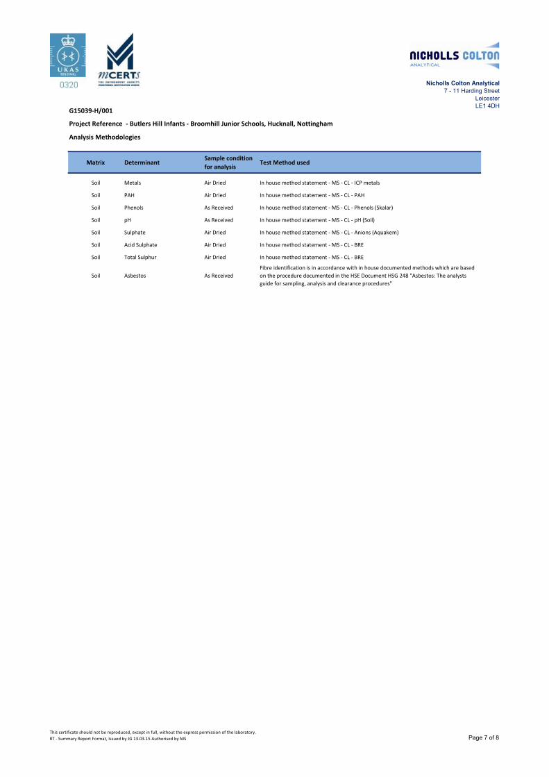
Analysis Methodologies
Matrix DeterminantSample condition
for analysisTest Method used
Soil Metals Air Dried In house method statement - MS - CL - ICP metals
Soil PAH Air Dried In house method statement - MS - CL - PAH
Soil Phenols As Received In house method statement - MS - CL - Phenols (Skalar)
Soil pH As Received In house method statement - MS - CL - pH (Soil)
Soil Sulphate Air Dried In house method statement - MS - CL - Anions (Aquakem)
Soil Acid Sulphate Air Dried In house method statement - MS - CL - BRE
Soil Total Sulphur Air Dried In house method statement - MS - CL - BRE
Soil Asbestos As Received
Fibre identification is in accordance with in house documented methods which are based
on the procedure documented in the HSE Document HSG 248 "Asbestos: The analysts
guide for sampling, analysis and clearance procedures"
Project Reference - Butlers Hill Infants - Broomhill Junior Schools, Hucknall, Nottingham
This certificate should not be reproduced, except in full, without the express permission of the laboratory.
RT - Summary Report Format, Issued by JG 13.03.15 Authorised by MS Page 7 of 8

Nicholls Colton Analytical
7 - 11 Harding Street
Leicester
LE1 4DHG15039-H/001
WAC Analysis Methodologies
Matrix DeterminantSample condition
for analysisTest Method used
Soil TOC Air Dried In house method statement - MS - CL - TOC
Soil LoI Air Dried BS 1377, Part 3, 1990
Soil BTEX As Received In house method statement - MS - CL - VOC and BTEX
Soil PCB As Received In house method statement - MS - CL - PCB
Soil Mineral Oil As Received In house method statement - MS - CL - TPH
Soil PAH Air Dried In house method statement - MS - CL - PAH
Soil pH Air Dried In house method statement - MS - CL - pH (Soil)
Eluate Metals Leached In house method statement - MS - CL - Water Metals
Eluate Anions Leached In house method statement - MS - CL - Anions (Aquakem)
Eluate Phenol Index Leached In house method statement - MS - CL - Phenols (Skalar)
Eluate DOC Leached In house method statement - MS - CL - DOC
Project Reference - Butlers Hill Infants - Broomhill Junior Schools, Hucknall, Nottingham
This certificate should not be reproduced, except in full, without the express permission of the laboratory.
RT - Summary Report Format, Issued by JG 13.03.15 Authorised by MS Page 8 of 8

Butlers Hill Infants/Broomhill Junior School, Hucknall, Nottinghamshire - Ground Investigation Report
Nicholls Colton Geotechnical Report No: G15039-H-IR
April 2015 Status: Final
DRAWINGS
G15039-H-IR/01 Site Location Plan
G15039-H-IR/02 Exploratory Hole Location Plan

Based upon the 2014 Ordnance Survey 1:50000 Scale Opendata SK54 Map with the permission of the Controller
of Her Majesty’s Stationery Office, Crown copyright Nicholls Colton and Partners Ltd.,
7-11 Harding Street, Leicester. Conventional License No. AL 100014431.
NICHOLLS COLTON GEOTECHNICAL Client:
7-11 Harding Street
Leicester LE1 4DH
Faithful + Gould
Project:
Butlers Hill Infants/Broomhill Junior School, Hucknall, Nottinghamshire
Drawing No: Title: Date:
G15039-H-IR/01 Site Location Plan April 2015
SITE
North
