integration of technology & geological understanding for reservoir … · 2017-11-23 ·...
TRANSCRIPT
Integration of technology & Geological understanding for reservoir characterization – A casestudy of Ahmedabad-Nandej-Wasna area of Cambay Basin, India
S. C. Malviya*, Dhruvendra Singh, Rajeev Tandon, Anand Kumar, Rajiv Paul,Sanjay Kumar Singh, Ambrish Kumar Tripathi
GEOPIC, Oil & Natural Gas Corporation Ltd., [email protected]
Keywords
K-IX/K-X Parasequence, P-impedance
Summary
Nandej-Ahmedabad fields, located in southern part ofAhmedabad-Mehsana tectonic block of Cambay Basin arein active phase of development for Middle Eocene reservoirexploitation. The field is gradually approaching the maturephase and recent development activity for K-IX and K-Xreservoirs have got setbacks and pose the challenges forfuture exploitation strategies.
Seismic mapping has brought out presence of three sets offaults trending NW-SE, WNW-ESE & NNE-SSW. Thesefaults play very important role in hydrocarbonaccumulation in the area. The structure maps clearlydisplay the structural highs of Ahmedabad and WasnaFields and the saddle between them as Nandej Field.
Integration of log response, lithological characters andlaboratory analysis has led to preparation of litho-faciesmaps. The facies maps vividly bring out the sedimentdispersal pattern in the study area. In Nandej Field, the K-IX & K-X reservoirs have been deposited under tideinfluence of Lower Delta Plain environment largelycomprising of fine grained sandstone and siltstone facies.Within the K-IX unit, at least four channels are presentwith NE-SW orientation occurring as bottom sand unit andtop sand unit.
The P-imp attribute maps along the stratal slices of theImpedance volume were generated on the basis of P-Impedance range classification, four dominant facies, viz.sandstone, siltstone, shale and coal have been identified andtheir distribution depicted in time and space. The sanddistribution pattern inferred from this map corroboratesfairly well with the sand-silt isolith trends and the drilledwell data.
The findings have resulted into identification of areas forexploratory and development thrust.
Introduction
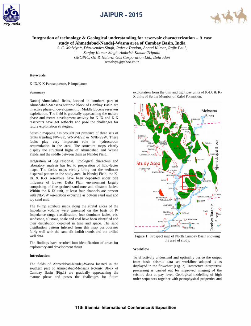
The fields of Ahmedabad-Nandej-Wasna located in thesouthern part of Ahmedabad-Mehsana tectonic Block ofCambay Basin (Fig.1) are gradually approaching themature phase and poses the challenges for future
exploitation from the thin and tight pay units of K-IX & K-X units of Sertha Member of Kalol Formation.
Figure 1: Prospect map of North Cambay Basin showingthe area of study.
Workflow
To effectively understand and optimally derive the outputfrom basic seismic data set workflow adopted is asdisplayed in the flowchart (Fig. 2). Interactive interpretiveprocessing is carried out for improved imaging of theseismic data at pay level. Geological modelling of highorder sequences together with petrophysical properties and
11th Biennial International Conference & Exposition

Reservoir characterization in Ahmedabad-Nandej-Wasna area of Cambay Basin through integrated G&G interpretation – A case study
geophysical attributes are amalgamated with revisedstructural framework to reveal the intricacies of reservoir.
Figure 2: Description of flowchart here.
Geological History
The study area is a part of Ahmedabad-Mehsana tectonicblock of Cambay Basin, an extensional basin andencompasses entire Tertiary sequence having mainly clasticsedimentation. The generalized stratigraphy of the entiresuccession from Middle Jurassic to Recent for the Cambaybasin on the basis of outcrop and well data is shown in(Fig.3).
Figure 3 Generalized stratigraphy of Cambay Basin
The Deccan Trap forms the technical basement in the studyarea which is overlain by Paleocene syn-rift sediments ofOlpad Formation. The Olpad Formation exhibits complexlithological association and basically a trap derivative.Petrographic study revealed the development of three
lithofacies viz volcanic conglomerate, volcanic sandstoneand claystone within this formation. The Olpad Formation,is overlain by transgressive Cambay Shale of lower Eoceneage. Cambay shale is divided into Older Cambay shale(OCS) and younger Cambay shale Formations. Thearenaceous reservoir facies developed within youngerCambay shale are Mandhali, Mehsana and Chhatralmembers. The younger Cambay shale is unconformablyoverlain by Kalol Formation of middle Eocene age.
Lithofacies and Depositional Framework
The Kalol Formation is divided into Sertha and Wavelmembers from bottom to top where the transgressiveKansari Shale occurs between the two. The Sertha memberincludes the pay horizons of K-X, K-IX and K-VIII whileK-VI +VII horizons occur within Kansari Shale (Figure 4).The Kalol Formation is overlain by transgressive TarapurShale of Early Oligocene age.
Figure 4 Log motif showing the reservoir units withinKalol Formation
The sequences of study area are in conformity withRegional Stratigraphy of the Cambay Basin. Kalol (K-IX &K-X) pay zones are well developed in the area. Both thehorizons consists of fine grained sandstone/siltstone andsilty shale / carbonaceous shale layers. Sideritic shales havealso been reported in many core study reports.
The main producing sedimentary unit corresponding to theKalol Formation K-IX and K-X (Sertha Member) consistsof two parasequences representing two independentepisodes that are separated from each other by a persistenttransgressive shale. The K-IX parasequence is the primetarget of the study as this is the major hydrocarboncontributor in this area
11th Biennial International Conference & Exposition

Reservoir characterization in Ahmedabad-Nandej-Wasna area of Cambay Basin through integrated G&G interpretation – A case study
K-IX PARASEQUENCE
Deposition of K-IX parasequence started with marinetransgressive shale which persists throughout the area. Thesand isolith map (Figure 5) indicated depositional inputfrom north and northeast direction in two different axes:one passing through high across the main Ahmedabad Fieldand the other lobe towards east of main field throughBakrol-Hirapur area. The western channel has been probedby drilling of number of wells of Nandej field and easternchannel has been confirmed by drilling of wells inAhmedabad Field and needs further exploratory inputs forfield growth. Redistribution of sediment along the crossfaults can be seen in the southern part of Channel-2. Thepre-existing east west oriented cross faults appear to haveplayed the role in the sediment dispersal pattern.
Figure 5 Sand/Silt Isolith map of K-IX unit
The unit is divisible into two units i.e. upper and lower(Figure 6). The facies of upper unit is lithologicallycharacterised by fine quartzwacke with sideritic clay(kaolinite) occupying the intergranular pore space. Thesedimentary structures include “wavy and flaser bedding,interlayer carbonaceous lamination of clays. This facies isalso characterised by low volume clay content, goodporosity, permeability and low water saturation. The faciesis well developed in the central part of Nandej and south ofAhmedabad area and might have been deposited as tidalbars & channels.
The facies of lower unit is characterised by interlayeredcarbonaceous shale, sideritic claystone and occasionallysiltstone. This facies is developed throughout and appearsto have been deposited in tidal regime.
Four channels (1 to 4 from west) have been mapped in thisarea. These channel consist of two sand units. Out of theseChannel-3 is described below. The upper sand unit of K-IXis largely persistent throughout whereas lower sand unit isabsent in the Wasna area to the SW. Reservoir facies isexpected to be better developed in the northeastern partwhere upper sand unit may not be present.
Figure 6 Electrolog correlation along channel-3 of K-IXunit
Inversion modelling and reservoir facies
To fine tune the attribute studies and to circumvent thelimitations of conventional amplitude attributes due tomasking effect of coal and low frequency content, post-stack inversion was carried out. To build the inversionmodel, elastic logs of 21 processed wells were used.Feasibility study for the same was carried out to evaluatepossibility of discrimination of different lithologies.Different cross-plots were generated for the purpose. TheGR Vs P-imp crossplot (Fig. 8) suggests separation of coalmainly, while other lithologies (sand/silt/shale) do not showdiscernible separation and even P-imp range from 4000 –5000 g/cm3 * m/s display mixing of some coal with theother lithologies.
Fig. 8 Cross Plot (P-Impedance vs. GR)
11th Biennial International Conference & Exposition

Reservoir characterization in Ahmedabad-Nandej-Wasna area of Cambay Basin through integrated G&G interpretation – A case study
The P-imp Histogram (Fig.9) also corroborate the same.However, from the skew of frequency (number ofoccurrences) of the different lithologies, as seen in the saidhistogram, it can be inferred that shale has mainly moderateP-impedances (4200 – 4800 g/cm3 * m/s) while P-impedances of silt is mainly in the range of 4800 – 6200g/cm3 * m/s and that of sand is mainly in the range of 6200– 7700 g/cm3 * m/s. The possibility of partial overlappingof the said lithologies across the limits of the rangesmentioned cannot be ruled out, though.
Figure 9 Histogram (P-Impedance)
On the basis of the broad P-impedance range classification,P-imp attribute maps were generated along stratal slicescovering the K-IX pay window. After analyzing theindividual slices, average P-imp maps for the full windowcorresponding to K-IX pay were extracted. The P-imp mapcorresponding to K-IX pay (Plate-10) depicts lateral spreadof the lithologies (based on P-imp range) which may befairly indicative of the likely clastic dispersal trends andreservoir distribution. The sand distribution pattern inferredfrom this map corroborates fairly well with the sand-siltisolith trends and the drilled well data.
Figure10 Sand isolith map overlay on Impedance of K-IXUnit
Discussion and prospectivity analysis
The Cambay – Kalol petroleum system is a prolific systemthat occurs in the Ahmedabad-Mehsana block. Theprincipal source of this system is the shale of the CambayFormation, while the principal reservoirs are deltaicsandstones of the Kalol Formation.
Modeling of the generation histories of the source rockintervals within this petroleum system have beenundertaken by various authors. Vitrinite reflectance valueswithin Cambay Formation range from 0.5 - 2.2% Ro.Samanta (1993) suggests that the onset of generation withinthe Cambay Formation began in Late Oligocene / EarlyMiocene (approx., 25 ma), with peak generation occurringtowards the end of the deposition of the JhagadiaFormation (approx. 6 Ma).
Figure11 Time structure map of K-IX Unit
The time maps close to K-IX have brought out thestructural high features of Ahmedabad, Nandej andnorthern part of Wasna area with a low between Nandejand Wasna field (Figure11). These maps show the deepestpart of the area to the west. The structure is gradually risingtowards north and NE of the area. The map clearly displaysthe structural highs of Ahmedabad and Wasna Fields andthe saddle between them as Nandej Field. Three sets ofnormal faults trending NW-SE, WNW-ESE & NNE-SSWhave been brought out in the area. These faults play veryimportant role in hydrocarbon accumulation in the area.These structures appear to have developed post Mid-Miocene compressional tectonics related to Himalayanorogeny and were available for entrapment at the time ofpeak hydrocarbon generation.
11th Biennial International Conference & Exposition

Reservoir characterization in Ahmedabad-Nandej-Wasna area of Cambay Basin through integrated G&G interpretation – A case study
The hydrocarbon prospectivity of K-IX & K-X units in thestudy area has been identified by integrating all the G&Gstudies, viz. Sand / Silt isolith maps, Impedance attributeand GME model. The areas marked with green and pink inthe Prospectivity map indicate the thrust areas forexploration and development activities respectively (Figure12). Good reservoir facies in channel-3 & 4 is expected inthese areas.
Fig. 12 Prospectivity map for K-IX sand
Conclusions
Electrolog correlation displays structural variancedifferentiating the fields of Ahmedabad, Nandej andWasna. It also displays the facies variation within K-IX parasequence. The reservoir facies developed justbelow the K-IX coal is better as compared to thatdeveloped in the lower part. Poor reservoir facieswithin K-IX is seen in the wells which are located inclose proximity to the Inter distributary bay area.
K-IX reservoirs have been deposited under tideinfluence environment of lower delta plain comprisingfine grained sandstone and siltstone facies. Finer scalesand geometry depicting major channel axis have beendelineated for these units. Within the K-IX unit, atleast four channels are present with NE-SWorientation occurring as bottom sand unit and top sandunit.
The P-imp attribute maps along the stratal slices of theImpedance volume were generated. On the basis of P-Impedance range classification four dominant facies,viz. sandstone, siltstone, shale and coal have beenidentified. The stratal slices within K-IX displaywidespread distribution of coal above the shale andsiltstone/sandstone reservoir within the NE-SW
oriented channels. Eastern part of the area displaybetter reservoir facies as compared to western part.
Based on the geological and geophysical inputs theareas have been identified for Development (markedin pink) and Exploration (marked in green) thrust.
References
1. Chandra, P.K., and Chowdhary, L.R. (1969):Stratigraphy of the Cambay Basin, ONGC Bull., 6(2),page 37-50.
2. Kundu, J. and Wani, M.R. (1993): Integratedgeological studies and hydrocarbon prospectevaluation of Cambay Basin, unpublished report,ONGC, KDMIPE, Dehradun.
3. Pandey, J., Singh, N.P., Krishna, B.R., Sharma, D.D.,Parakh, A.K. and Nath,S.S. (1993), Lithostratigraphyof Indian Petroliferous Basins: Document - III-Cambay Basin. KDMIPE Publication.
4. Parakh, A.K., Shau, S.K., Prakash, A., Ms. Negi, A.,Pillai, S., Aswal, Srivastava, H.S., Ms. Niranjan, N.(2007) Sequence Stratigraphic Frame Work CambayBasin, unpublished report, ONGC, WON, Baroda.
AcknowledgmentsThe authors are highly indebted to Shri Anil Sood, ED-Head of Institute, GEOPIC for being a constant source ofinspiration during the course of this study. The suggestionmade by Dr. Hari Lal, GM (GP), INTEG during the courseof this study is also gratefully acknowledged.
The views expressed herein are entirely those of the authorsand need not necessarily reflect the view of ONGC Ltd.
11th Biennial International Conference & Exposition