integrating flood risk management and land use...
TRANSCRIPT

Integrating Flood Risk Management and Land Use Planning ICLEI FORUM 2013 Bonn 2 June 2013 Dr Robin Bloch Technical Director: ICF GHK

A forward looking approach: Integrated Urban Flood Risk Management
— Operational guidance on how to manage the risk of floods in a quickly transforming urban environment and changeable climate.
— Over fifty case studies, a series of “how-to” sections and a set of guiding policy principles illustrate the state-of-the art on integrated urban flood risk management.
— The Guide serves as a comprehensive primer for decision and policy makers, technical specialists, central, regional and local government officials, and concerned stakeholders in the community sector, civil society and non-governmental organizations, and the private sector.
— Complemented by Summary for Policymakers and Working Paper
— http://www.gfdrr.org/urbanfloods

1. Every flood risk scenario is different: there is no flood management blueprint.
2. Designs for flood management must be able to cope with a changing and uncertain future.
3. Rapid urbanization requires the integration of flood risk management into regular urban planning and governance.
4. An integrated strategy requires the use of both structural and non-structural measures and good metrics for “getting the balance right”.
5. Heavily engineered structural measures can transfer risk upstream and downstream.
6. It is impossible to entirely eliminate the risk from flooding.
7. Many flood management measures have multiple co-benefits over and above their flood management role.
8. It is important to consider the wider social and ecological consequences of flood management spending.
9. Clarity of responsibility for constructing and running flood risk programs is critical.
10. Implementing flood risk management measures requires multi-stakeholder cooperation.
11.Continuous communication to raise awareness and reinforce preparedness is necessary.
12.Plan to recover quickly after flooding and use the recovery to build capacity.
12 guiding policy principles
A Three Step Process – and Five Stages
• Understand the causes and risk of urban flooding
• Develop an integrated approach which combines structural (controlling the flow of water) and non-structural (building capacity to cope with flooding, emphasising better planning of urban development) measures
• Latter often do not require huge investment upfront, but rely on good understanding of flood hazard and on adequate forecasting systems (and, arguably, discussion still tends to focus on flood defenses)
• Implement with involvement of multiple institutions and stakeholders
• Five steps:
– 1. Understand
– 2. Identify
– 3. Plan
– 4. Finance and Implement
– 5. Evaluate

Urban agglomerations with more than 750,000 inhabitants, 2010
— Climate change is increasingly understood to have a significant impact on flood risk.
— New and intensified phase of urbanization coupled with spatial expansion is implicated in and compounds flood risk.
Urban areas have been hit particularly hard by
increases in flooding impact
IBR
D 3
89
21
NO
VE
MB
ER
20
11

— Current urban growth patterns appear to have significantly amplified the exposure of urban populations to flood (and other) hazard risks, notably the settlements of the urban poor – and at all levels of urban hierarchies
— Growth involves urban expansion occurring horizontally (peripheral expansion) and/or vertically (up slopes) – outwards and upwards
— That said, the global urban transition needs to be seen as essentially suburban in character (peripheral location, lower density and physical and social newness), with land cover expanding at double the rate of population growth
— Suburbs are at current and future risk as expansion occurs in hazard-prone areas: e.g., floodplains and slopes; here both extensive risk and intensive risk need attention
Urbanization – as suburbanization

Overview of flood risk management options
(catchment scale)
Ba
ca A
rch
ite
cts
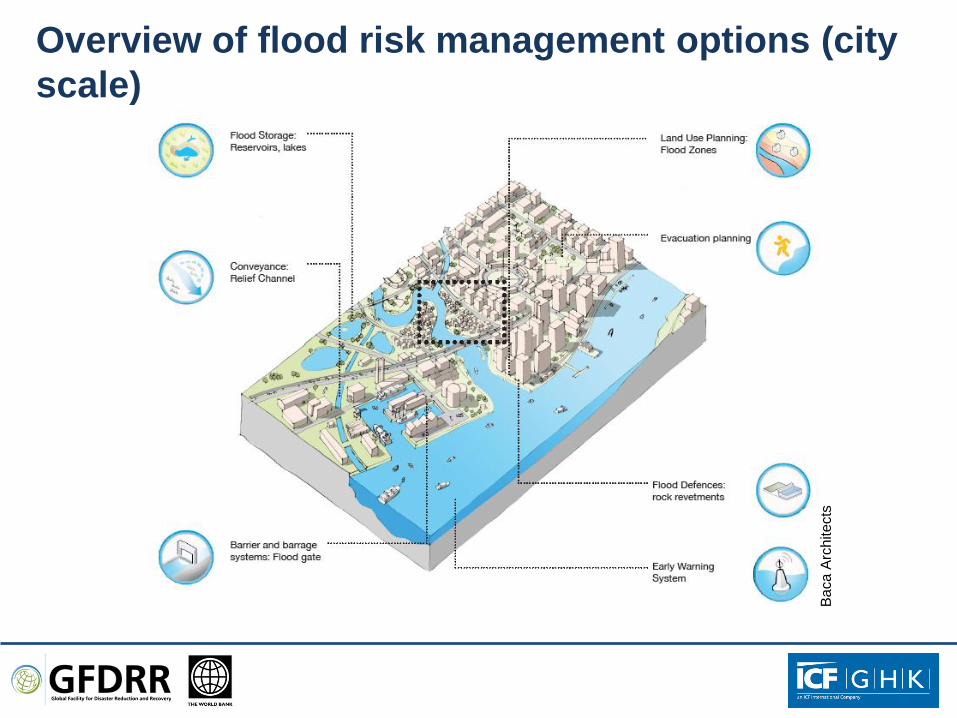
Overview of flood risk management options (city
scale)
Ba
ca A
rch
ite
cts
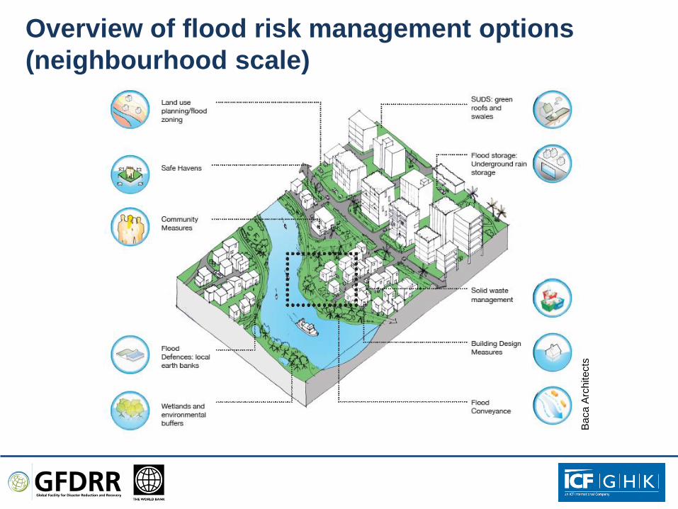
Overview of flood risk management options
(neighbourhood scale)
Ba
ca A
rch
ite
cts
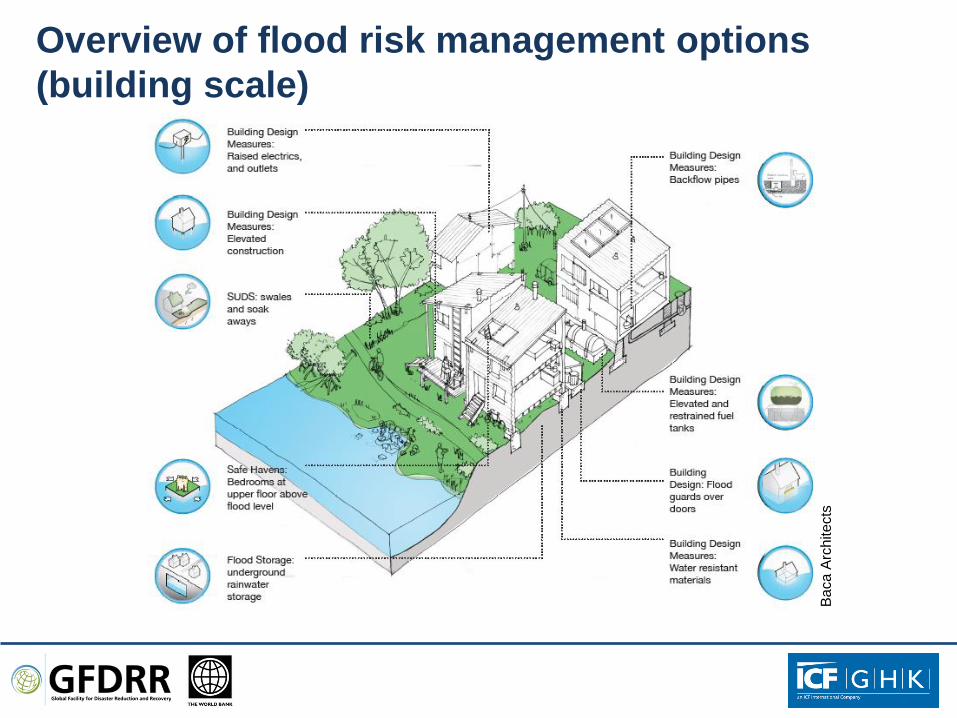
Overview of flood risk management options
(building scale)
Ba
ca A
rch
ite
cts

Connecting flood risk management to urban planning
— Flood risk is not ‘outside’: it is constitutive of the current era of urbanization and urban development
— It is vital to link urban flood risk management to urban planning and management, including land administration, land use planning, housing provision, urban infrastructure delivery and basic service provision
— Improved drainage systems and solid waste management are key for the latter
— There are opportunities:
– The rapid expansion of urban built up areas provides the prospect of developing new settlements that incorporate integrated flood management techniques from the outset.
– Recovery plans as an opportunity for reconstructing safer and stronger communities which have the capacity to better withstand future flooding.

Integrating flood risk management and land use planning: the need for better understanding
— To begin with, little actual research on why people (continue to) live in floodplains and other flood-prone areas – or move/migrate there
— Survey in Kumasi, Ghana: cost of moving, proximity to economic activity and livelihoods, and convention (long-run residences; habituated to flood impacts)
— Such work necessary to inform urban spatial policy and spatial planning in order to develop better options and incentives for the location of economic and residential activities
— The combination of concentration and deconcentration in any spatial planning situation also requires better evidence bases
— Compact urban form and high density can work to increase flood hazard risk by concentrating more people and assets in hazard-prone areas and by increasing impermeable surfaces and poor quality construction

Integrating flood risk management and land use
planning: principles
• Flood risk management/water management policy and plans (floodplain, river basin, surface water, etc.) need to be both a starting point for and embedded within land use policy and planning processes
• Policy guidance for flood risk needs to correlated with planning policy in the form of guidelines (flooding areas, change over time, permitted development, etc): integrating broader flood risk policy principles into the land use planning process
• More effort needed to investigate and map floodplains and flood-prone areas for the land use plan making process
• Flood zones (or designated flood areas) so identified to become integral aspect of determining and specifying appropriate land uses (restricting and permitting)
• Regulations to be drafted as necessary to control or restrict development – and situated within land use and building controls : appropriate uses, flood risk assessment, minimum design standards, drainage/surface water management, retrofitting, etc)
• Several sound practice examples to draw on for inspiration
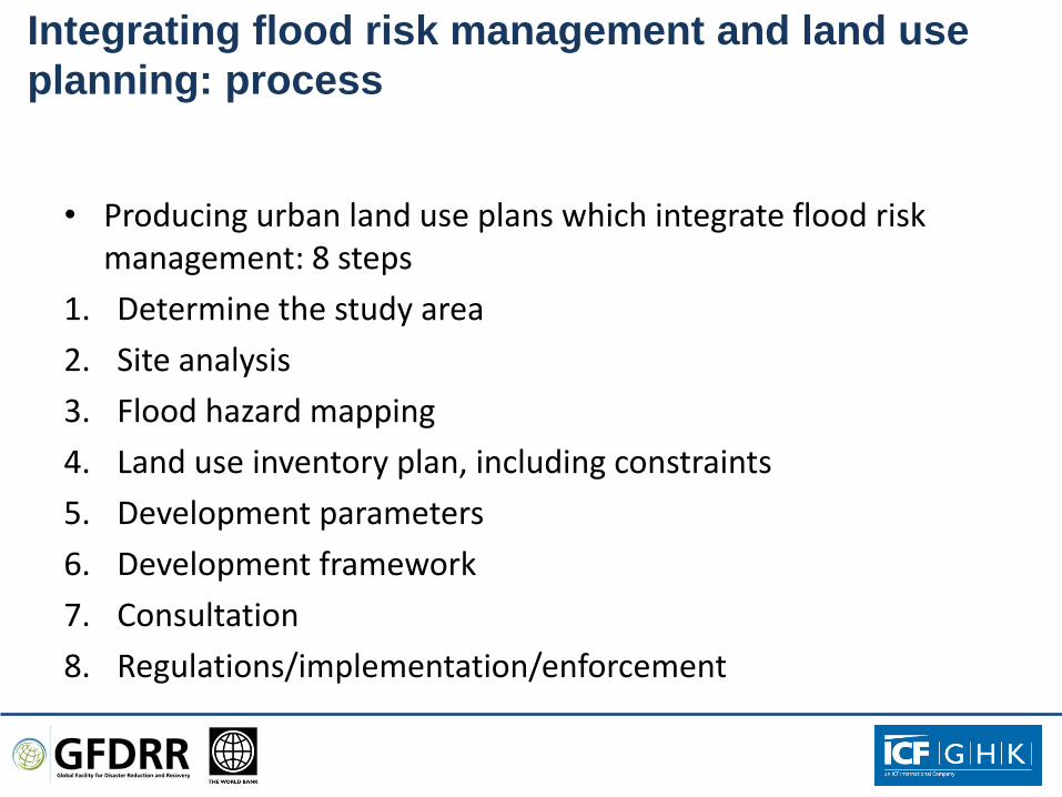
Integrating flood risk management and land use
planning: process
• Producing urban land use plans which integrate flood risk management: 8 steps
1. Determine the study area
2. Site analysis
3. Flood hazard mapping
4. Land use inventory plan, including constraints
5. Development parameters
6. Development framework
7. Consultation
8. Regulations/implementation/enforcement
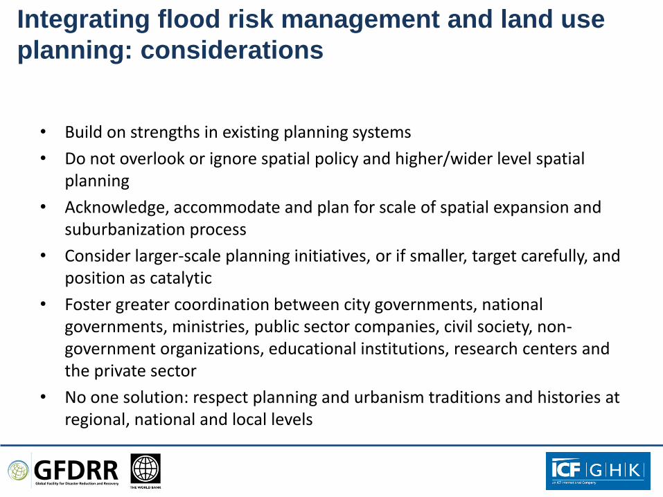
Integrating flood risk management and land use
planning: considerations
• Build on strengths in existing planning systems
• Do not overlook or ignore spatial policy and higher/wider level spatial planning
• Acknowledge, accommodate and plan for scale of spatial expansion and suburbanization process
• Consider larger-scale planning initiatives, or if smaller, target carefully, and position as catalytic
• Foster greater coordination between city governments, national governments, ministries, public sector companies, civil society, non-government organizations, educational institutions, research centers and the private sector
• No one solution: respect planning and urbanism traditions and histories at regional, national and local levels

Principles: — Living with Water: Adapting to increased
flood frequency and severity, likely to happen with climate change
— Making Space for Water: Working with natural processes to provide room for the river and sea to expand in times of flood and reduce reliance on defenses, where possible.
— Zero Carbon: Providing all energy needs from renewable resources on site, such as wind, tidal and solar power.
Policy lessons: — Flood risk management — Renewable energy — Development and amenity
The LifE Project – Making Space for Water
— The LifE project adopted a non-defensive approach to flood risk management, which marked a shift from traditional thinking by permitting water into sites in a controlled manner to make space for water.
Baca A
rchitects

Thank you – and for further information:
Dr Robin Bloch [email protected]
Technical Director: Urban Planning
ICF GHK