integrated water resources strategy
TRANSCRIPT

Oregon’s Integrated Water Resources Strategy Discussion Draft
December 22, 2011 Prepared By Oregon Water Resources Department Oregon Department of Environmental Quality Oregon Department of Fish and Wildlife Oregon Department of Agriculture

Table of Contents Foreword.......................................................................................................................................... 5 Acknowledgements.......................................................................................................................... 6 Executive Summary.......................................................................................................................... 8 Overview ........................................................................................................................................ 10 Introduction ...................................................................................................................................11
The Purpose of This Document .................................................................................................11 What It Is…and What It Is Not....................................................................................................11 Cross‐Cutting Issues ................................................................................................................. 12 How to Use This Document .......................................................................................................13
Components of the IWRS Framework ........................................................................................... 15 Vision ....................................................................................................................................... 15 Goals and Objectives ................................................................................................................ 16 Critical Issues............................................................................................................................ 16 Guiding Principles..................................................................................................................... 16
PART I — OBJECTIVE: Understand Oregon’s Water Resources..................................................... 18 Critical Issue A: Further Understand Oregon’s Limited Water Supplies & Systems ....................... 19
The Status of Oregon’s Water Resources – Water Quantity...................................................... 19 The Status of Oregon’s Water Resources – Water Quality ........................................................ 22 The Status of Oregon’s Water Resources – Ecosystems ........................................................... 23
Critical Issue B: Improving Water‐Related Information ................................................................. 27 Tools We Use to Manage Water Quantity................................................................................. 27 Tools We Use to Manage the Link between Groundwater and Surface Water .......................... 28 Tools We Use to Manage Water Quality ................................................................................... 29 Regulatory Tools We Use to Protect Public Health ....................................................................31 Regulatory Tools We Use to Protect Ecological Health............................................................. 32 Recommended Action #1.A ..................................................................................................... 35
Critical Issue C: Further Understand Our Water Management Institutions.................................... 38 Water Quantity Institutions...................................................................................................... 38 Water Quality Institutions ........................................................................................................ 38 Ecosystem Protection and Restoration Institutions .................................................................. 39 Agency Roles and Responsibilities............................................................................................ 39 Recommended Action #1.B...................................................................................................... 40
PART II — OBJECTIVE: Understand Out‐of‐Stream and Instream Needs...................................... 41 Critical Issue D: Further Define Out‐of‐Stream Demands ............................................................. 42
How Water Is Used in Oregon................................................................................................... 42 Measuring Water Use ............................................................................................................... 48 Pre 1909 Water Right Claims .................................................................................................... 50 Recommended Actions #2.A – 2.C ........................................................................................... 50
Critical Issue E: Further Define Instream Needs ............................................................................ 52 Water Instream Supports Oregon’s Economy........................................................................... 52 Water Instream is Needed for Ecosystem Health...................................................................... 53 Recommended Actions #3.A – 3.B ............................................................................................57
PART III — OBJECTIVE: Understand Coming Pressures ................................................................ 58 Critical Issue F: The Water & Energy Nexus................................................................................... 59
Energy Needs in the Water Industry ......................................................................................... 59 Water Needs in the Energy Industry ......................................................................................... 60 Gaining Water & Energy Efficiencies ........................................................................................ 63

Recommended Actions #4.A – 4.C ........................................................................................... 64 Critical Issue G: Climate Change ................................................................................................... 66
Studies and Partnerships .......................................................................................................... 66 Climate Change Predictions for Oregon ................................................................................... 67 Recommended Actions #5.A – 5.B ............................................................................................71
Critical Issue H: The Water and Land‐Use Nexus............................................................................73 Land‐Use Planning Goals...........................................................................................................73 Changing Land Uses................................................................................................................. 74 Information Needs of Decision‐Makers .................................................................................... 74 State and Local Coordination ....................................................................................................77 Low Impact Development & Green Infrastructure .....................................................................77 Recommended Actions #6.A – 6.B........................................................................................... 78
Critical Issue I: Water‐Related Infrastructure ................................................................................ 80 Regional Infrastructure Needs .................................................................................................. 80 Infrastructure – End of Life ....................................................................................................... 84 Dam Safety .............................................................................................................................. 85 Recommended Actions #7.A – 7.B............................................................................................ 85
PART IV — OBJECTIVE: Meet Out‐of‐Stream and Instream Needs............................................... 87 Critical Issue J: Education and Outreach ....................................................................................... 88
Outreach through K through 12 education ............................................................................... 88 Outreach through Higher Education......................................................................................... 89 Outreach through the Community ........................................................................................... 90 Recommended Actions #8.A – 8.D........................................................................................... 91
Critical Issue K: Funding For Oregon’s Water................................................................................. 93 Funding an Integrated Water Resources Strategy .................................................................... 93 Operational Funds.................................................................................................................... 93 Funding Local Water Resource Projects ................................................................................... 95 Recommended Actions #9.A – 9.D........................................................................................... 99
Critical Issue L: Place‐Based Efforts ............................................................................................ 100 Regional (Sub‐Basin) Water Resources Planning .................................................................... 100 Partnership with Tribes and Neighboring States .................................................................... 106 Recommended Actions #10.A – 10.B.......................................................................................111
Critical Issue M: Water Resource Development............................................................................112 Water‐Use Efficiency and Water Conservation ........................................................................112 Built Storage ...........................................................................................................................116 Water Re‐Use ..........................................................................................................................123 Recommended Actions #11.A – 11.C .......................................................................................125
Critical Issue N: Healthy Ecosystems & Public Health ..................................................................127 The Role of Water in Public Health ..........................................................................................127 The Role of Water in Ecosystem Health and Resiliency .......................................................... 128 Voluntary Tools to Protect and Restore Oregon’s Ecosystems ................................................130 Informational Tools to Protect Ecosystem and Public Health ..................................................133 Developing a Market for Ecosystem Services ..........................................................................135 Recommended Actions #12.A – 12.H ......................................................................................138

Appendices....................................................................................................................................143 Appendix A: The Process of Developing the IWRS................................................................. 144 Appendix B: State and Federal Policies Underpinning Water Management in Oregon...........151 Appendix C: A Sampling of Water‐Related Permitting Programs.......................................... 168 Appendix D: Infrastructure Funding Sources .......................................................................... 171 Appendix E: Acronyms ........................................................................................................... 173 Appendix F: References..........................................................................................................175
Essays: Techniques & Technologies
Use of Airborne Remote Sensing (LiDAR) to Understand Oregon’s Water Resources .............. 34 Long‐Term Water Demand Forecasting: Accounting for New Factors ..................................... 45 Mapping Evapotranspiration from Satellite ............................................................................. 49 Assessment of Groundwater‐Dependent Ecosystems ............................................................. 54 Achieving Energy Independence at Wastewater Treatment Plants.......................................... 59 Conduit Hydroelectric Projects: A View from Irrigated Agriculture in Central Oregon............. 61 The Willamette Valley Resiliency Compact .............................................................................. 70 Using County Ordinances & Codes to Collect Data and Make Permitting Decisions..................75 Financing Water Projects with Bonds....................................................................................... 83 Integrated Funding: The Whole Watershed Restoration Initiative........................................... 97 Does Regional Water Planning Really Work? ......................................................................... 104 The Umatilla River Vision ........................................................................................................107 Piping and Lining Projects in Central Oregon..........................................................................114 Groundwater Storage Techniques in Oregon: ASR/AR........................................................... 117 Use of Class A Water for Irrigation ......................................................................................... 124 Restoration after Placer Mining ..............................................................................................132 Environmental Markets: A Catalyst for Environmental Protection and Restoration ...............136

Foreword Now is the time to secure Oregon’s water future by creating a strategy to understand and meet Oregon’s water needs. The following Discussion Draft represents more than two years of work on the development of an Integrated Water Resources Strategy for our state. The issues described in this document encompass water quantity, water quality, and ecosystem issues throughout Oregon. This document features Recommended Actions in a dozen water‐related categories and provides a blueprint for the State of Oregon to follow, as it strives to understand and meet its water needs, now and in the future. These Recommended Actions span topics from developing new water supply to enhancing streamflows, from growing Oregon businesses to protecting the waters that make Oregon a great place to live. From its strong beginnings in community meetings throughout the state, this discussion draft has matured with help of three Advisory Groups and emerges here in its “almost finished” form. The final version of the Integrated Water Resources Strategy is scheduled for consideration for adoption by the Water Resources Commission in August 2012, with implementation thereafter. As agency directors, we are committed to the implementation of this Strategy in the following months and years, seeking resources as appropriate over time. We invite you to read through this Discussion Draft and provide any suggestions or comments you care to make by March 15 to [email protected]. Phillip C. Ward, Director, Dick Pedersen, Director Oregon Water Resources Department Oregon Department of Environmental Quality Roy Elicker, Director Katy Coba, Director Oregon Department of Fish and Wildlife Oregon Department of Agriculture December 2011

Acknowledgements Oregon’s first Integrated Water Resources Strategy has sprung from the work of many individuals, who helped develop the public process, content, outreach materials, and final publication. Our many thanks to: The Policy Advisory Group, which met quarterly over the course of 24 months to provide policy guidance and suggestions. Members included Glenn Barrett, Michael Campbell, Jay Chamberlin, John DeVoe, Dennis Doherty, Bill Gaffi, Patrick Griffiths, Todd Heidgerken, Tod Heisler, Teresa Huntsinger, Tracey Liskey, Peggy Lynch, Janet Neuman, Eric Quaempts, Mike Seppa, Lorna Stickel, Richard Wells, and Joe Whitworth. Our facilitator, Cynthia Solie, led the group discussions throughout all eight meetings and helped the Project Team design each of these conversations. The Agency Advisory Group, which also met quarterly and provided much of the technical materials included in this publication, such as statistics, graphs, maps, program descriptions,and more. Members included the Oregon Water Resources Department (Ruben Ochoa), the Oregon Department of Environmental Quality (Christine Svetkovich, Eugene Foster, and Neil Mullane), the Oregon Department of Fish and Wildlife (Rick Kepler), Oregon Department of Agriculture (Brent Searle and Stephanie Page), Business Oregon (Karen Homolac), Department of Consumer and Business Services (Gabrielle Schiffer), Department of Energy (Kip Pheil, Rebecca Sherman, and Matt Hale), Department of Forestry (Jim Paul, David Morman, Peter Daugherty, and Roger Welty), the Department of Geology & Mineral Industries (Vicki McConnell and Gary Lynch), the Department of Housing and Community Services (Karen Chase), Oregon Health Authority‐Drinking Water Program (David Leland, Karen Kelly, Tom Pattee, and Curtis Cude), the Department of Land Conservation and Development (Rob Hallyburton and Jeff Weber), Oregon Parks and Recreation Department (Jan Houck, Alex Phillips, and Jim Morgan), the Department of State Lands (Kevin Moynahan and Lori Warner‐Dickason), the Department of Transportation (Frannie Brindle and William Fletcher), the Infrastructure Finance Authority (Lynn Schoessler), Oregon State University – Institute of Natural Resources (Gail Achterman and Lisa Gaines), the Oregon Watershed Enhancement Board (Melissa Leoni), and the Governor’s Office (Richard Whitman, Brent Brownscombe (2011 to present) and Mike Carrier, Christine Valentine, Jessica Hamilton Keys, Suzanne Knapp, and Jane Bacchieri (2009‐2011)). The Federal Liaison Group, which met quarterly and provided technical guidance, including peer review of the “techniques and technologies” sections. Members included Bonneville Power Administration (John Taves, Rozy Mazaika, and Crystal Ball), the Bureau of Reclamation (Dawn Wiedmeier, Wendy Christensen, and Julia Pierko), the National Oceanic & Atmospheric Association (Kim Kratz), Natural Resources Conservation Service – USDA (Meta Loftsgaarden), U.S. Army Corps of Engineers (Kevin Brice, Laura Hicks, and Kathryn Warner), the U.S. Environmental Protection Agency (Tony Barber and Joel Salter), U.S. Fish and Wildlife Service (Gary Ball), U.S. Forest Service (Trish Carroll), and the U.S. Geological Survey (Greg Fuhrer). From the beginning, several process consultants provided valuable suggestions about how to structure the gathering and processing of information. They included Mark Anderson and Michelle Girts from CH2M Hill; Mark Bateman from Segue Point LLC; Terry Bucholz from Integrated Water Resource Solutions LLC; Jim Cogan from Cogan Owens Cogan; Turner Odell, Steve Greenwood, and Pete Dalke from Portland State University’s Oregon Solutions; and Bill Ross from Ross & Associates. A talented group of interns plugged in throughout the process to keep various public events and outreach efforts on track. They included Cyndi Comfort, Jeffrey Pierceall, Skye Root, and Ryan Vanden Brink. Partners from Oregon State University helped in gauging public opinion and awareness throughout the project. They included Brent Steele, Monica Hubbard, Erika Wolters, and Samuel Chan.
IWRS Discussion Draft, December 2011
6

Other colleagues in western states shared decades worth of planning experience and guidance to get us started. They included Kamyar Guivetchi from the State of California, Carolyn Britton from the State of Texas, John Wells from the State of Minnesota, and Dan Haller and Derek Sandison from the State of Washington. Special thanks to Michael Arthur for the Integrated Water Resources Strategy logo and original graphics, to Lisa Snowden at HDR for printing our map gallery, to Tawny Gall who created the kids coloring pages used in our 2010 Open Houses, and to Jan Lee who reviewed and edited key sections of the energy chapter. Open House hosts, funders, and facilitators helped immensely with our initial data gathering efforts. Volunteer facilitators included: Amanda Benton, Terry Black, Jeff Blackwood, Terry Buchholz, Sam Chan, Robert Coffan, John Dean, Eric Dittmer, Adena Green, Megan Kleibacker, Sally Puent, Linda Rowe, Tami Sasser, Matt Shinderman, Cynthia Solie, and students and faculty from the Oregon Institute of Technology’s Conflict Dispute Resolution Program. These individuals and a gallery of pictures are available on‐line: http://www.wrd.state.or.us/OWRD/LAW/docs/IWRS/Open_House_Photos.pdf. Our agency directors, Phil Ward, Dick Pedersen, Roy Elicker and Katy Coba, led these efforts and provided counsel throughout the process, as did our Commission chairs John Jackson, Bill Blosser, Martha Rae, and Bob Levy. Three additional Water Resource Commissioners, Mary Meloy, Jeanne LeJeune, and John Roberts, drafted the original issue papers around which we held our earliest public discussions. Finally, thank you to the legislators who launched these efforts in the first place, including Representative Bob Jenson, Representative Jefferson Smith, and Senator Jackie Dingfelder. ~ The IWRS Project Team, December 2011 Brenda Bateman, Project Manager, Dept. of Water Resources Karen Tarnow, Dept. of Environmental Quality Bruce McIntosh, Dept. of Fish and Wildlife Ray Jaindl, Dept. of Agriculture Alyssa Mucken, Policy Coordinator, Dept. of Water Resources Ken Stahr, Science Coordinator, Dept. of Water Resources
IWRS Discussion Draft, December 2011
7
Executive Summary Water is one of Oregon’s most precious natural resources. With more than 100,000 miles of rivers and streams, 360 miles of coastline, and some of the cleanest lakes in the world, Oregon is renowned for its water. Our rivers and streams not only provide natural beauty, but they supply the water necessary for drinking, recreation, industry, agriculture, and fish and wildlife. Today, however, the management of water resources in Oregon is facing a number of significant challenges. Surface water is nearly fully allocated during the summer months and groundwater is showing declines in many areas. More than 1,861 waterbodies are impaired and not meeting water quality standards. Twenty‐four fish species have been identified as threatened or endangered under the Endangered Species Act, while another 31 are listed as state sensitive species. During 2009, the 75th Legislative Assembly passed House Bill 3369, directing the Water Resources Department to develop a statewide, Integrated Water Resources Strategy (IWRS) to help Oregon meet its future water needs in terms of water quantity, water quality, and ecosystem functions. House Bill 3369 states that the Water Resources Department shall develop a strategy to implement ORS 536.220(2), which calls for the state to “formulate a coordinated, integrated state water resources policy and provide means for its enforcement, that plans and programs for the development and enlargement of the water resources of this state be devised and promoted and that other activities designed to encourage, promote and secure the maximum beneficial use and control of such water resources and the development of additional water supplies be carried out by a single state agency…” The bill further clarifies these mandates by stating that the Oregon Water Resources Department “shall design the strategy to meet Oregon’s in‐stream and out‐of‐stream water needs.” The bill directs the Oregon Water Resources Department (OWRD) to work in close cooperation with the Oregon Department of Environmental Quality (ODEQ) and the Oregon Department of Fish and Wildlife (ODFW), to develop the Integrated Water Resources Strategy and to develop data on an ongoing basis to forecast these needs. The bill also adds the Oregon Department of Agriculture (ODA) to the list of key agencies responsible for reporting progress on the Strategy in 2011. The Environmental Quality Commission, Fish and Wildlife Commission, and the Board of Agriculture shall receive notice prior to adoption of the Strategy. The Water Resources Commission has responsibility for formal adoption of the Strategy. The bill requires the Strategy to include objectives as well as actions designed to meet these objectives under the Strategy. It also requires: a description of relevant factors such as population growth and land‐use change; plans and recommendations related to the challenges presented by climate change; provisions to ensure communication and partnership with key stakeholders; a description of functions and roles to be played by other agencies; and finally, public policy options and recommendations. The Recommended Actions resulting from efforts over the past 24 months are summarized as follows: #1 Understanding Water Resources / Supplies / Institutions Action 1.A Fill in Knowledge Gaps — Physical Water Resources Action 1.B Further Integrate Water Resource Management in Oregon
#2 Understanding Oregon’s Out‐of‐Stream Needs Action 2.A Fill in Knowledge Gaps — Long‐Term Water Demand Forecasts Action 2.B Improve Water‐Use Measurement Action 2.C Determine Pre‐1909 Water Right Claims
IWRS Discussion Draft, December 2011
8
#3 Understanding Instream Needs Action 3.A Fill in Knowledge Gaps – Flows Needed (Quantity & Quality) to Support Instream Needs Action 3.B Fill in Knowledge Gaps – Needs of Groundwater Dependent Ecosystems
#4 The Water & Energy Nexus Action 4.A Analyze the Effects on Water from Energy Development Projects & Policies Action 4.B Take Advantage of Existing Infrastructure to Develop Hydroelectric Power Action 4.C Promote Strategies that Increase/Integrate Energy & Water Savings
#5 Climate Change Action 5.A Support Continued Basin‐Scale Climate Change Research Efforts Action 5.B Assist with Climate Change Adaptation and Resiliency Strategies
#6 The Water and Land‐Use Nexus Action 6.A Improve Integration of Water Information into Land‐Use Planning (and Vice Versa) Action 6.B Encourage Low‐Impact Development [LID] Practices
#7 Water‐Related Infrastructure Action 7.A Encourage Regional (Sub‐Basin) Approaches to Water and Wastewater Systems Action 7.B Develop and Upgrade Water and Wastewater Infrastructure
#8 Education and Outreach Action 8.A Support Oregon’s K‐12 Environmental Literacy Program Action 8.B Provide Education and Training for Oregon’s Next Generation of Water Experts Action 8.C Host Community Education and Training Opportunities Action 8.D Identify On‐going Water‐Related Research Needs
#9 Funding Action 9.A Fund Development and Implementation of Oregon’s IWRS Action 9.B Fund Water Resource Management Activities at the State Level Action 9.C Fund Communities Needing Feasibility Studies for Water Conservation, Storage, and Re‐use Projects Action 9.D Fund Communities Implementing Water Development Projects
#10 Place‐Based Approaches Action 10.A Undertake Regional (Sub‐Basin) Integrated, Water Resource Planning Action 10.B Partner with Tribes and Neighboring States in Long‐Term Water Resource Management
Action #11 Water Resource Development Action 11.A Increase Water‐Use Efficiency and Water Conservation Action 11.B Improve Access to Built Storage Action 11.C Encourage Additional Water Re‐Use
#12 Public Health and Ecosystem Health Action 12.A Improve the Safety of Oregon’s Drinking Water Action 12.B Reduce the Use of and Exposure to Toxics and other Pollutants Action 12.C Implement Water Quality Pollution Control Plans Action 12.D Improve Watershed Health, Resiliency, and Capacity for Natural Storage Action 12.E Develop Additional Instream Protections Action 12.F Prevent and Eradicate Invasive Species Action 12.G Protect and Restore Instream Habitat and Habitat Access for Fish and Wildlife Action 12.H Assist in the Development of Ecosystem Services Markets
IWRS Discussion Draft, December 2011
9

Overview
IWRS Discussion Draft, December 2011
10
INTRODUCTION
Introduction to the IWRS
THE PURPOSE OF THIS DOCUMENT In 2009, the Oregon Legislature passed House Bill 3369. Section 42 of the bill directed the Oregon Water Resources Department to take the lead in developing an Integrated Water Resources Strategy for the state of Oregon. The bill further directed the Water Resources Department to partner with the Department of Environmental Quality, Department of Fish and Wildlife, and Department of Agriculture to produce the Strategy. The Water Resources Commission has responsibility for adopting the Strategy in 2012, after consulting with its counterparts—the Environmental Quality Commission, the Fish and Wildlife Commission, and the Board of Agriculture. The fundamental purpose of this document is to understand Oregon’s water needs and to articulate a strategy to meet those needs into the future. Updates are due every five years thereafter. Unlike traditional state water plans, this document takes a look at both instream needs (where water remains and is used in the environment) as well as out‐of‐stream needs (where water is diverted for use). These needs include not only traditional water quantity, but also water quality and ecosystem needs. Such an approach requires participation and leadership from many public and private sector partners who play an important role in managing and protecting water in Oregon. In this way, this document serves as an “integrated” approach to understanding and meeting Oregon’s water needs. This document is meant to serve as a long‐term blueprint, highlighting areas that require more discourse and effort, whether these be scientific, public policy, outreach, or funding in nature. For many years, Oregonians have engaged in these discussions and have documented necessary next steps within their own industry sectors or stakeholder groups. This document brings together the results of many of these discussions into one place. WHAT IT IS…AND WHAT IT IS NOT During the development of this document, citizens and organizations from across Oregon’s landscape provided their best thinking about how to understand and meet Oregon’s water needs. Their perspectives were wide ranging, well‐informed by personal and professional experience, and strongly stated. This document represents recurring themes, heard time and again, that have risen to a level of urgency. Two such emerging themes are the need to pursue and maintain Oregon’s economic development and the need to protect and restore Oregon’s environment. This document contains recommendations to further both areas—each in support of the other. It is important to note that the development and implementation of this Strategy relies in the first order on collaboration and voluntary efforts. The document identifies areas where incentives, whether financial, technical, or policy in nature, could serve as powerful tools for progress. It also identifies where public and private partnerships could stretch our dollars and further our instream and out‐of‐stream goals.
IWRS Discussion Draft, December 2011
11
Just as importantly, the Strategy is not intended to remove or jeopardize already‐existing water rights, wastewater or stormwater permits, or other local, state, and federal approvals. The Strategy does not relinquish any existing authorities. Successful investment in Oregon’s long‐term economy and environment requires a foundation of certainty and law, and this Strategy upholds the rule of law and the long‐standing history that supports it. CROSS‐CUTTING ISSUES This document is organized in a way that supports the authorizing language of HB 3369 (now residing in ORS 536.220). It focuses first on issues and recommendations related to “understanding” Oregon’s water needs. The first half of the document is therefore data‐centric, describing programs already in place to measure and understand Oregon’s physical water resources, its water‐related institutions, and its projected water needs into the future. Recommended actions in this section focus on improving and modernizing these programs and data. Next, the text focuses on issues and recommendations related to “meeting” Oregon’s water needs. The second half of the document focuses more heavily, therefore, on policy development, field work, and development of tangible projects in Oregon communities. As with any document of this nature, there are number of cross‐cutting issues whose threads run throughout. Many of these issues are indicated by {brackets}, referencing other sections of the document. Four cross‐cutting issues, in particular, merit extra attention from the reader. These four issues are of vital importance to Oregon’s water future and they are present or implied in every section of this document. They are: groundwater, climate change, funding, and institutional coordination. Groundwater. Oregon monitors and manages groundwater at the state level, unlike several other western states. This approach enables the state to track groundwater availability and groundwater quality, make science‐based permitting decisions, and to provide this information, wherever possible, to local planners and other decision‐makers. Unfortunately, groundwater science, so critical to economic and environmental decision‐making, has been given short‐shrift in public and private budgets during recent decades, causing major knowledge gaps at local, state, and federal levels. You can find major groundwater‐related recommendations in several of the Recommended Actions [#1, 3, 4, 5, 6, 11, and 12]. Climate Change. The authorizing language of HB 3369 highlights climate change in several instances, calling for recommendations regarding continuous monitoring of climate change effects on Oregon’s water supply and for recommendations regarding water user actions that are necessary to address climate change. These water user actions will draw upon a suite of tools and approaches, including increased water conservation and efficiency, increased storage, and increased capacity for resiliency in riparian areas, forest lands, wetlands, and floodplains. Adaptation will mean taking a closer look at how climate change may affect the water rights, crop production, and migration patterns already in place today. You can find major climate change recommendations in several of the Recommended Actions [#1 – 7, 11, and 12]. Funding. Although much of the content in this Strategy focuses on policy and administration, no implementation can occur without investing the time, energy, and expertise in these areas. Recommended Action #9 focuses specifically on funding for work at the state and local level, but each of the Recommended Actions contains a funding component, upon which each action rests. An analysis of other budgets in other western states reveals million, if not billions, of dollars dedicated to the development and protection of state water resources. These are orders of magnitude beyond what Oregon historically has spent in support of its most precious natural resource. Today, the agencies that protect and manage Oregon’s natural resources
IWRS Discussion Draft, December 2011
12

receive less than one percent of the state’s General Fund budget. Water represents an even thinner slice of that investment. You can find major funding recommendations in Recommended Action #9. Institutional Coordination. No entity is an island, when it comes to water management and protection. In Oregon, all water is publicly owned, and there are a multitude of organizations with specific responsibilities and authorities related to the management of Oregon’s water resources. These organizations reside at the local, state, tribal and federal level, and each has a different mandate, funding base, and constituency. From planning and policy development to data collection and project implementation, there are certainly many ways these organizations could more efficiently communicate, pay for, and implement their goals. However, there are also a number of hopeful signs, ranging from clear divisions of labor and coordination at the state level to improved on‐line communication platforms. You can find major institutional recommendations in several Recommended Actions [#1 – 10]. HOW TO USE THIS DOCUMENT The following document is wide‐ranging in the amount of materials it covers and Recommended Actions that result. The at‐a‐glance summary of Recommended Actions contained in the Executive Summary may serve as a quick reference to find your preferred topic. The order in which recommended actions are organized does not imply a ranking of priority or importance. However, there are a number of symbols described below and used throughout the text that may prove useful in prioritizing Oregon’s next steps.
Oregon is a national leader in many of the techniques and technologies featured here, including underground water storage, riparian restoration, canal piping and lining, LIDAR remote sensing, and ecosystem services markets. Authors from private sector consulting firms, non‐profit organizations, and other partners have contributed 17 essays describing how these techniques and technologies are adding value in Oregon, and how they are likely to evolve into the future. Opinions expressed in these essays belong to the authors alone. Look for the “Techniques and Technologies” symbol accompanying each essay. A series of Recommended Actions represents the core of the Integrated Water Resources Strategy. These Recommended Actions numbered 1A through 12H provide guidance to address the critical issues described throughout the document. Bulleted paragraphs accompanying each Recommended Action offer suggestions for next steps. Look for the “Recommended Actions” symbol marking a set of recommendations at the end of each Chapter. Quite a bit of work remains to characterize Oregon’s water resources and its future needs. Much of the work will be led by state and federal agencies, who already have established protocols and responsibilities in these areas. However, much of the desired information will be gathered through surveys, literature reviews, and local data gathering. Much of the processing, analysis, and sharing could be led by universities, non‐profit organization, local governments, tribes, and private research firms. Look for the “Research” symbol, signaling Recommended Actions that need additional research assistance from partners. A long‐term plan cannot be implemented all at once. In order to help to prioritize those actions that need immediate attention in the first five years (2012 – 2017), this document identifies several “key” Recommended Actions. Key recommended actions are ones specifically called out in the text of HB 3369 or useful as a springboard to move us in the direction of these actions. They include filling in knowledge gaps, assisting with climate change adaptation strategies, placing
IWRS Discussion Draft, December 2011
13

water data into the hands of land‐use planners, improving water‐related funding at all levels, and conducting local water‐resource planning. Look for the “Key” symbol, denoting priority Recommended Actions. Many of the concepts mentioned here are still evolving. Some, if pursued, will require clarifications or additional authorities spelled out in statute or rule. The first opportunity for legislative action will occur during the 77th Oregon Legislative Assembly, which convenes in 2013. Look for the Legislative “gavel” indicating Recommended Actions that will likely require follow‐up in the Oregon Legislature.
Organization names highlighted in brackets [ ] indicate proposed lead entities for each recommended action. They do not represent a complete list of partners.
IWRS Discussion Draft, December 2011
14

COMPONENTS OF THE IWRS FRAMEWORK
Components of the IWRS Framework
The Project Team developed a Framework with the help of Advisory Groups and stakeholders, in order to provide a visual roadmap for discussion. The Framework contains a number of components that led to the Recommended Actions contained in this document. These components include vision statements, goals and objectives, critical issues, and guiding principles. Recommended Actions themselves appear throughout the subsequent document. Appendix A describes in detail the three‐year timeline, institutional structures, and public involvement plan used to develop all of these components. VISION The first component of the framework is the Water Resources Commission’s vision for the overall process. This vision focuses on the approach and process that should be used in order to develop the Strategy, emphasizing the principles of working together, and striving to meet the needs of future generations. Following that is a vision for the physical water resources of Oregon, developed by the Policy Advisory Group. This vision is more focused on the health of water resources, looking out 50 years from now.
The Commission’s Vision A statewide integrated water resources strategy will bring various sectors and interests together to work toward the common purpose of maintaining healthy water resources to meet the needs of Oregonians and Oregon’s environment for generations to come. The Policy Advisory Group’s Vision Everywhere in our State, we see healthy waters, able to sustain a healthy economy, environment, and cultures & communities.
~ Healthy waters…are abundant and clean. ~ A healthy economy…is a diverse and balanced economy, nurturing and employing the State’s
natural resources and human capital to meet evolving local and global needs, including a desirable quality of life in urban and rural areas.
~ A healthy environment…includes fully functioning ecosystems, including headwaters, river systems, wetlands, forests, floodplains, estuaries, and aquifers.
~ Healthy cultures and communities… depend on adequate and reliable water supplies to sustain public health, safety, nourishment, recreation, sport, and other quality of life needs.
IWRS Discussion Draft, December 2011
15

GOALS AND OBJECTIVES There are two goals and four objectives listed in the framework that are derived from the language of House Bill 3369. The goals and objectives provide the direction needed to better understand and meet Oregon’s water needs.
Goal 1: Improve our understanding of Oregon’s Water Resources Objective: Understand water resources today Objective: Understand both instream and out‐of‐stream needs Objective: Understand the coming pressures that affect our needs and supplies Goal 2: Meet Oregon’s Water Resource Needs Objective: Meet Oregon’s Instream and Out‐of‐Stream Needs
CRITICAL ISSUES Critical issues that should be addressed in the IWRS (first implementation phase 2012 – 2017) are listed below and more fully described throughout this document. The order and manner in which these issues are displayed indicates neither a priority nor chronological order in which they will be addressed.
Further Understand Limited Water Supplies & Systems
Improve Water Quality & Quantity Information
Further Understand our Water Management Institutions
Further Define Out‐of‐Stream Needs / Demands
Further Define In‐stream Needs / Demands
Water and Energy Nexus
Climate Change
Water and Land‐Use Nexus
Water‐Related Infrastructure
Education & Outreach
Funding Place‐Based / Regionalization / Basin Efforts Water Resource Development (including built storage)
Healthy Ecosystems & Public Health (including natural storage)
GUIDING PRINCIPLES The guiding principles were designed to help develop recommended actions. These principles were initially developed from early discussions with stakeholders and a Water Resources Commission planning sub‐committee in early 2009, and later refined through discussions with the Policy Advisory Group.
Accountable and Enforceable Actions: Ensure that actions comply with existing water laws and policies. Actions should include better measurement and enforcement tools to ensure desired results. Balance: The Strategy must balance current and future instream and out‐of‐stream needs supplied by all water systems (above ground and below ground). Actions should consider and balance tradeoffs between ecosystem benefits and traditional management of water supplies. Collaboration: Support formation of regional, coordinated, and collaborative partnerships that include representatives of all levels of government, private and non‐profit sectors, tribes, stakeholders, and the public. Collaborate in ways that help agencies cut across silos. Conflict Resolution: Be cognizant of and work to address longstanding conflicts. Facilitation by the State: The State should provide direction and maintain authority for local planning and implementation. Where appropriate, the State sets the framework, provides tools, and defines the direction.
IWRS Discussion Draft, December 2011
16

Incentives: Where appropriate, utilize incentive‐based approaches. These could be funding, technical assistance, partnerships / shared resources, regulatory flexibility, or other incentives. Implementation: Actions should empower Oregonians to implement local solutions; recognize regional differences, while supporting the statewide strategy and resources. Take into account the success of existing plans, tools, data, and programs; do not lose commonsense approach; develop actions that are measurable, attainable, and effective. Interconnection/Integration: Recognize that many actions (e.g. land‐use actions) in some way affect water resources (quality and/or quantity); recognize the relationship between water quantity and water quality; integrate participation of agencies and parties. Public Process: Employ an open, transparent process that fosters public participation and supports social equity, fairness, and environmental justice. Advocate for all Oregonians. Reasonable Cost: Weigh the cost of an approach with its benefits to determine whether one approach is better than another, or whether an approach is worth pursuing at all. Actions should focus on reducing the costs of delivering services to the state’s residents, without neglecting social and environmental costs. Science‐based, Flexible Approaches: Base decisions on best available science and local input. Employ an iterative process that includes “lessons learned” from the previous round. Establish a policy framework that is flexible. Build in mechanisms that allow for learning, adaptation, and innovative ideas or approaches. Streamlining: Streamline processes without circumventing the law or cutting corners. Avoid recommendations that are overly complicated, legalistic, or administrative. Sustainability: Ensure that actions sustain water resources by balancing the needs of Oregon’s environment, economy, and communities.
IWRS Discussion Draft, December 2011
17
PART I — OBJECTIVE: Understand Oregon’s Water Resources
IWRS Discussion Draft, December 2011
18
CRITICAL ISSUE A: FURTHER UNDERSTAND OREGON’S LIMITED WATER SUPPLIES & SYSTEMS
Critical Issue A
Further Understand Oregon’s Limited Water Supplies and Systems
Water is one of Oregon’s most precious natural resources. With more than 100,000 miles of rivers and streams, 360 miles of coastline, and more than 1,400 named lakes, some of them the cleanest lakes in the world, Oregon is renowned for its water. Our rivers and streams not only provide natural beauty, but they supply the water necessary for drinking, recreation, industry, agriculture, and fish and wildlife. Today, however, the management of water resources in Oregon is facing a number of significant challenges. Surface water is nearly fully allocated during the summer months and groundwater is showing declines in many areas. More than 1,861 waterbodies are impaired and not meeting water quality standards. Twenty‐four fish species have been identified as threatened or endangered under the Endangered Species Act, while another 31 are listed as state sensitive species. In very simple terms, there is not enough water where it is needed, when it is needed, to satisfy existing and future out‐of‐stream and instream uses. The following pages describe in more detail the challenges facing Oregon in the areas of water quantity, water quality, and ecosystems.
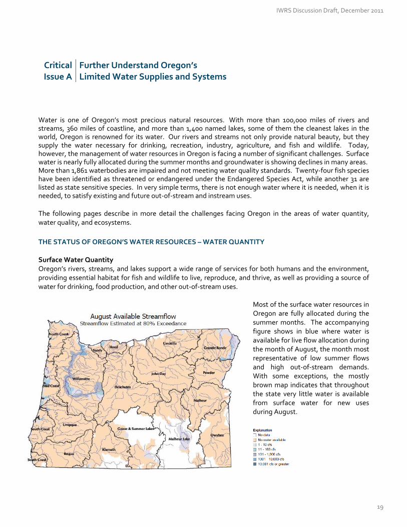
THE STATUS OF OREGON’S WATER RESOURCES – WATER QUANTITY Surface Water Quantity Oregon’s rivers, streams, and lakes support a wide range of services for both humans and the environment, providing essential habitat for fish and wildlife to live, reproduce, and thrive, as well as providing a source of water for drinking, food production, and other out‐of‐stream uses.
Most of the surface water resources in Oregon are fully allocated during the summer months. The accompanying figure shows in blue where water is available for live flow allocation during the month of August, the month most representative of low summer flows and high out‐of‐stream demands. With some exceptions, the mostly brown map indicates that throughout the state very little water is available from surface water for new uses during August.
IWRS Discussion Draft, December 2011
19

However, some water, indicated in blue, is available during the winter months for new uses, either instream or out‐of‐stream. For example, water users could store available surface water to supply late season or year‐round uses. This map illustrates water availability during the month of January, when flows are typically higher.
Groundwater Quantity Groundwater, one of the Nation’s most valuable resources, occurs almost everywhere beneath the land surface. Groundwater comprises approximately 5 percent of available freshwater resources. It is a major source of water for springs, lakes, and wetlands, feeding streams and rivers throughout the year and augmenting stream flow in late summer months.
As surface water becomes fully allocated in most places throughout the state, water users have also become heavily reliant upon groundwater resources to meet their needs. Approximately 70 percent of all Oregon residents rely solely or in part on groundwater for drinking water purposes, and more than 90 percent of rural Oregonians rely on groundwater for drinking water. This increased pressure, along with other factors, has resulted in the depletion of groundwater levels in several areas of the state. This has resulted in a number of challenges, including declining aquifers, administratively restricted areas and difficulty with “conjunctive management.” Significantly decreasing groundwater levels have led to administratively designating groundwater management areas as either “classified,” “critical,” or “withdrawn.” Although groundwater development is an option for new uses in some parts of Oregon, the opportunities are shrinking. The Water Resources Department has designated 14 “groundwater limited areas” in Oregon, 12 of which are located within the Willamette Valley. These designations limit future use of certain aquifers to exempt uses of groundwater only. A few limited areas allow minimal irrigation use or withdrawal of groundwater for rural residential fire protection systems. Many of these areas have limited future groundwater uses since the early 1990’s. There are seven existing “critical groundwater areas,” in Umatilla, Morrow, Wasco, Washington, and Malheur County. In several of these areas, the Water Resources Department has set specific requirements on the total amount of water that may be appropriated. In some of these critical areas, the Department has the authority to reduce groundwater use annually, even for existing water right holders. There are two “areas of withdrawal” in Oregon, the Pomona and Priest Rapids aquifers in the Mosier area of Wasco County and the Columbia River Basalt aquifer in the Victor Point area of Marion County. These withdrawn areas do not allow any future development of the groundwater resource.
IWRS Discussion Draft, December 2011
20

All aquifers are susceptible to over development. The Columbia River Basalt formations, in particular, are of concern, because their hydrologic and geologic structure makes it easy to pull water out faster than the aquifer can naturally recharge itself. The Columbia River Basalts are deep aquifers, with ancient water that has seeped in over hundreds, if not thousands, of years. Five of the state’s seven critical groundwater areas are in Columbia River Basalt formations. The Interaction between Surface Water and Groundwater In many instances, applicants for new groundwater appropriations are proposing use from groundwater aquifers that are hydraulically connected to surface water. Frequently, groundwater applications are being denied or limited because they are proposing use from aquifers that can substantially interfere with surface waters that are fully appropriated.
Courtesy of USGS, 1998 publication
Surface water interacts with groundwater in three basic ways: (1) streams gain water from inflow of groundwater, via springs or seepage, through the streambed (gaining streams), (2) streams lose water to groundwater by outflow through the streambed (losing streams), or (3) they do both, gaining in some reaches and losing in others. Gaining streams represent locations where cooler groundwater emerges and contributes to a stable base flow, helping to sustain flows during the summer months, and providing prime spawning conditions. Losing streams can act as a potential route of groundwater contamination, as polluted runoff enters streams that eventually percolate back into the ground.
IWRS Discussion Draft, December 2011
21
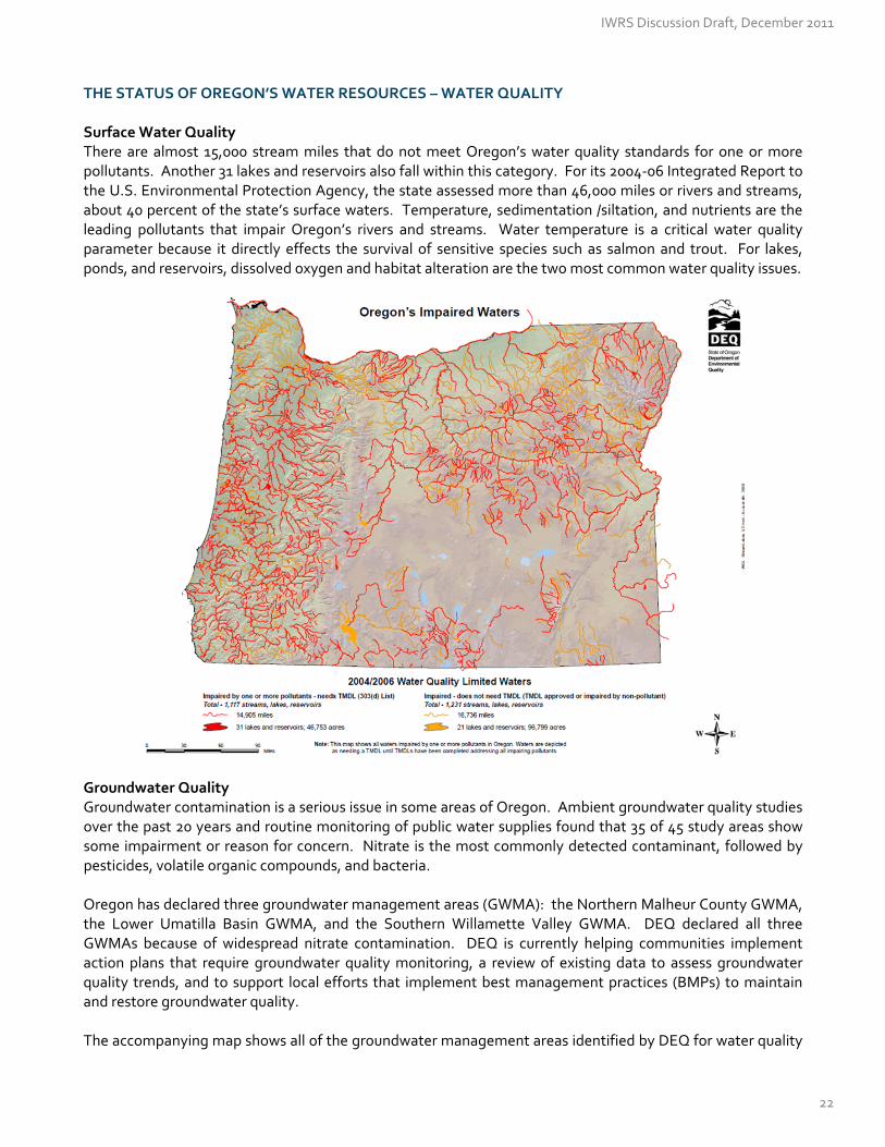
THE STATUS OF OREGON’S WATER RESOURCES – WATER QUALITY Surface Water Quality There are almost 15,000 stream miles that do not meet Oregon’s water quality standards for one or more pollutants. Another 31 lakes and reservoirs also fall within this category. For its 2004‐06 Integrated Report to the U.S. Environmental Protection Agency, the state assessed more than 46,000 miles or rivers and streams, about 40 percent of the state’s surface waters. Temperature, sedimentation /siltation, and nutrients are the leading pollutants that impair Oregon’s rivers and streams. Water temperature is a critical water quality parameter because it directly effects the survival of sensitive species such as salmon and trout. For lakes, ponds, and reservoirs, dissolved oxygen and habitat alteration are the two most common water quality issues.
Groundwater Quality Groundwater contamination is a serious issue in some areas of Oregon. Ambient groundwater quality studies over the past 20 years and routine monitoring of public water supplies found that 35 of 45 study areas show some impairment or reason for concern. Nitrate is the most commonly detected contaminant, followed by pesticides, volatile organic compounds, and bacteria. Oregon has declared three groundwater management areas (GWMA): the Northern Malheur County GWMA, the Lower Umatilla Basin GWMA, and the Southern Willamette Valley GWMA. DEQ declared all three GWMAs because of widespread nitrate contamination. DEQ is currently helping communities implement action plans that require groundwater quality monitoring, a review of existing data to assess groundwater quality trends, and to support local efforts that implement best management practices (BMPs) to maintain and restore groundwater quality. The accompanying map shows all of the groundwater management areas identified by DEQ for water quality
IWRS Discussion Draft, December 2011
22

reasons, as well as the areas administratively restricted by the Water Resources Department for groundwater quantity reasons.
Groundwater Management Areas and Restrictions
THE STATUS OF OREGON’S WATER RESOURCES – ECOSYSTEMS Fish Species The health of an “indicator species,” like the proverbial “canary in the coal mine” can be an indicator of overall ecosystem health, and can offer early signs of stress, such as disease or pollution. Out of numerous species that depend on Oregon’s water resources, the most visible indicator species are native salmonids (salmon, steelhead, and trout) that depend on cold clean water. Using these species as indicators of overall aquatic ecosystem health paints a dire picture. Since 1991, NOAA Fisheries’ Office of Protected Resources has listed 27 Pacific salmonid species under the Endangered Species Act (ESA), and has delisted zero species. Many populations of Chinook salmon, Coho, Chum, and Steelhead are at a fraction of their historic levels and are listed as threatened or endangered. In 2005, the Oregon Department of Fish and Wildlife published a Native Fish Status Report, noting that of 69 “Species Management Units,” a population count of Oregon native fish species, 35 units were “at risk” and 9 were already extinct.
IWRS Discussion Draft, December 2011
23

Species Management Units for Oregon Native Fish Species
Species Species
Management Units
Not at Risk
Potentially at Risk
At Risk
Extinct Not
Assessed
Salmon
Coho 5 2 0 1 2 0
Fall Chinook 5 2 2 1 0 0
Spring Chinook 8 0 2 4 2 0
Chum 2 0 0 1 1 0
Sockeye 2 0 0 0 2 0
Steelhead
Winter Steelhead 4 1 2 1 0 0
Summer Steelhead 7 2 1 3 1 0
Trout
Redband 7 0 2 5 0 0
Cutthroat 8 3 1 3 1 0
Bull 12 1 1 10 0 0
Other
Borax Lake Chub 1 0 0 1 0 0
Hutton Springs Tui Chub 1 0 0 1 0 0
Oregon Chub 1 0 0 1 0 0
Foskett Springs Speckled Dace 1 0 0 1 0 0
Pacific Lamprey 1 0 0 1 0 0
Western Brook Lamprey 1 0 0 1 0 0
Green Sturgeon 1 0 0 0 0 2
Oregon White Sturgeon 1 0 0 0 0 1
TOTALS 69 11 11 35 9 3
There are physical barriers, both natural and built, in the environment that affect the health of Oregon’s ecosystems and the species within those systems. Instream flows, land‐use practices, water withdrawals and discharges, lack of fish passage at diversions or in‐channel obstructions (dams), stream conditions (channel complexity, low flows, etc), invasive species, poor water quality, and climate change are some examples. Instream Flows In Oregon today, there are more than 1,400 instream flows legally protected by an instream water right. The purposes of many of these rights are to provide the streamflows necessary for migration, spawning, egg incubation, fry emergence, and juvenile rearing of various fish species, including sea‐run and resident cutthroat trout, Coho salmon, spring and fall Chinook salmon, summer and winter steelhead, and brown and rainbow trout. Other instream rights were established for water quality purposes. Since 1993, the Department has been keeping track of whether instream flows are met, measuring streamflows with continuous gages for more than 175 instream water rights. Of these rights, 113 have met the flow level requirements more than 80 percent of the time. It remains a challenge to protect streamflows with limited personnel in the field. Further, many of Oregon’s streams are not legally protected by instream water rights . Changes in Land Use All across Oregon, urbanization, agriculture, and certain forest practices have placed pressures on the overall health of aquatic ecosystems. The Willamette ecoregion, for example, has lost important river features, such
IWRS Discussion Draft, December 2011
24
as off‐channel aquatic habitat, gravel bars, and deep channel pools from changes to land use. Runoff of sediment from poorly designed logging, grazing, roads, urban and agricultural activities can enter waterways, which can have detrimental impacts on species reproduction and survival. Low Streamflows Out‐of‐stream diversions have resulted in lower flows in many rivers and streams, and in some cases, flows may not even exist in late summer months. Low streamflows conditions also occur during period of drought, or changes in precipitation patterns. Low flows often mean higher water temperatures and increased nutrient concentrations, contributing to poorer water quality. Historically accessible habitat for many aquatic species has been greatly reduced by changes in the hydrologic regime and improperly sized or misaligned culverts or even eliminated by dams. Poor Water Quality Poor water quality can put significant pressures on fish, wildlife and ecological systems. A 2007 DEQ study on wadeable, perennial streams throughout Oregon found the chemical and physical habitat parameters that most commonly fail to meet water quality standards or reference benchmarks are from human disturbances in riparian zones, alteration of slow water and fast water habitats, and increased fine sediments. This same study found that total suspended solids, loss of pool habitat, relative bed stability, and increased phosphorus levels pose the greatest risk to ecological conditions. Low streamflow can contribute to poor water quality, along with habitat loss, various pollutants, and the introduction of invasive species. Some toxics can be lethal to species, whereas others can result in reduced fish egg production, nest and brood abandonment, lower disease resistance, weight loss and other problems that can reduce adult survival and lower population abundance. Elevated stream temperature, a common water quality issue, increases the risk of disease‐related mortality and also results in increased competition for food. Passage Barriers Diversions that lack proper fish screening or by‐pass devices can increase fish mortality and injury as fish enter diversion ditches, machinery, or irrigated fields. In Oregon, the first fish screening laws showed up over 100 years ago in 1898. Providing fish passage over man‐made dams and diversions has been required since before statehood in 1859. Today, fish screens, passage or bypass devices are often required as condition of a water right permit or transfer. The Oregon Department of Fish and Wildlife operates the state’s fish screening program and has helped install more than 1,400 fish screens through its cost‐share program. Maintaining and inspecting fish screens to ensure they are properly working is challenging, considering their high exposure to debris, sediment, and changes in temperature that can cause screen damage and potentially lead to fish loss at the diversion. Invasive Species According to the Oregon Invasive Species Council, an invasive species in a non‐native species that can cause economic or environmental harm to human health. It can be a plant, animal or any other biological viable species that enters an ecosystem beyond its native range. Invasive species disrupt the natural function of an ecosystem by competing and replacing native species and disrupting the natural habitat. Oregon’s rivers, lakes, and streams are greatly affected by their presence. Invasive species can interfere with water use by reducing flow in irrigation canals and drainage ditches, which can result in flooding and damage to canal banks, structures and pumps. Municipal use and power development are also affected by invasive species, which can cause problems in water intake pipes, filtration equipment, and generation plants. Certain species of cyanobacteria, commonly referred to as blue‐green algae, can be both invasive and toxic. It can form thick foam or scum on the water’s surface and produces
IWRS Discussion Draft, December 2011
25
toxins or poisons that can cause serious illness or death in pets, livestock, wildlife and humans. Some of Oregon’s lakes and reservoirs are experiencing annual blue‐green algae outbreaks. Not only are invasive species harmful to ecosystem function, they are already very costly to Oregon’s agricultural economy. Cusack, Harte, and Chan (2009) estimate the impacts from 21 noxious weed species in Oregon at $125 million per year, and the control costs of the current sudden oak death outbreak to be $7 million annually. The authors note that the economic impacts to ecosystem function and human health have been less well studied at both state and national levels. The presence of invasive species is wide ranging, affecting our forests, farms, and our waters, which in turn impacts our economy, ecosystem and human health, and overall quality of life. Conclusion In all of these areas—water quantity, water quality, and ecosystem health—Oregon is falling short of the vision, goals, and objectives articulated at the beginning of this document. However, Oregon enters this next phase with a plethora of forward‐looking policies, program and tools at its disposal. The following pages will describe the positive steps already made and will recommend actions to strengthen them further.
IWRS Discussion Draft, December 2011
26

CRITICAL ISSUE B: IMPROVING WATER ‐RELATED INFORMATION
Critical Issue B
Improving Water‐Related Information
Oregon’s surface water and groundwater resources, by their very nature, are ever‐changing. By day, month and year, water resources managers need up‐to‐date information in order to form a more accurate picture of water quantity and quality statewide. This includes a measurement of baseline conditions, trends over time, and the effectiveness of our water management programs. Today, there are gaps in data sets that must be addressed, monitoring devices that need to be installed or replaced, and surface water assessments and groundwater investigations that must be completed or enhanced.
TOOLS WE USE TO MANAGE WATER QUANTITY Under Oregon law, all water is publicly owned. With some exceptions, cities, farmers, factory owners and other users must obtain a permit from the Water Resources Department to use water from any source. Landowners with water flowing past, through, or under their property do not automatically have the right to use that water without authorization from the Department. See Appendix B for more details about Oregon’s Water Code. In 1989, the Water Resources Commission directed the Water Resources Department to develop an allocation policy and establish a water availability program. The resulting tool, based on the state’s historic hydrologic record, helps to ensure that new water users will be able to use surface water at least 80 percent of the time, or eight out of every ten years. The amount of water available for use is affected by natural conditions, such as hydrology and climate, and existing uses of water, including groundwater withdrawals that might affect surface water. Oregon evaluates new requests for out‐of‐stream uses, while taking into account the needs of existing users, including instream water rights. Monitoring Streamflows – The Stream Gage Network The Water Resources Department operates more than 213 stream and reservoir gages throughout the state, maintaining a 100‐year record for many of them. About 150 of these gages are operated as near real‐time, and transmit data once every hour. Operating a stream gage network requires trained hydrographic technicians to keep the equipment operating properly, conduct regular measurements at various water elevations, and input the collected information into a central database. Staff review the data, make corrections based on field conditions, such as debris or ice, and finalize the records to meet computation standards established by the USGS. Currently, the state lacks sufficient financial resources to install, maintain, and process data from stream gages. The Department also hosts information from another 225 gages operated by the U.S. Geological Survey on its website. This network of stream gages is important in the management of Oregon’s surface water and is used by a variety of entities for multiple reasons. These data are used for making daily decisions, protecting instream and out‐of stream water rights, forecasting floods, planning for recreational activities, better understanding how much water is available for new uses, and tracking trends such as climate change.
IWRS Discussion Draft, December 2011
27
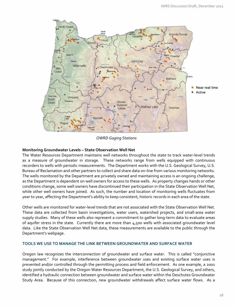
OWRD Gaging Stations
Monitoring Groundwater Levels – State Observation Well Net The Water Resources Department maintains well networks throughout the state to track water‐level trends as a measure of groundwater in storage. These networks range from wells equipped with continuous recorders to wells with periodic measurements. The Department works with the U.S. Geological Survey, U.S. Bureau of Reclamation and other partners to collect and share data on‐line from various monitoring networks. The wells monitored by the Department are privately owned and maintaining access is an ongoing challenge, as the Department is dependent on well owners for access to these wells. As property changes hands or other conditions change, some well owners have discontinued their participation in the State Observation Well Net, while other well owners have joined. As such, the number and location of monitoring wells fluctuates from year to year, affecting the Department’s ability to keep consistent, historic records in each area of the state. Other wells are monitored for water‐level trends that are not associated with the State Observation Well Net. These data are collected from basin investigations, water users, watershed projects, and small‐area water supply studies. Many of these wells also represent a commitment to gather long‐term data to evaluate areas of aquifer stress in the state. Currently there are more than 4,500 wells with associated groundwater level data. Like the State Observation Well Net data, these measurements are available to the public through the Department’s webpage. TOOLS WE USE TO MANAGE THE LINK BETWEEN GROUNDWATER AND SURFACE WATER Oregon law recognizes the interconnection of groundwater and surface water. This is called “conjunctive management.” For example, interference between groundwater uses and existing surface water uses is prevented and/or controlled through the permitting process and field enforcement. As one example, a 2001 study jointly conducted by the Oregon Water Resources Department, the U.S. Geological Survey, and others, identified a hydraulic connection between groundwater and surface water within the Deschutes Groundwater Study Area. Because of this connection, new groundwater withdrawals affect surface water flows. As a
IWRS Discussion Draft, December 2011
28
result, new groundwater withdrawals must now be “mitigated” with a similar amount of water placed instream, to offset the impact to surface water flows. Other examples of conjunctive management include aquifer storage & recovery and artificial groundwater recharge projects, where surface water is captured during high flows and stored underground for later use. Groundwater Investigations Managing surface water and groundwater in a coordinated way, or conjunctively, remains a challenge. A better understanding of the groundwater system helps quantify important relationships, such as the groundwater contribution to surface water and vice versa. A lack of data that describes the connection between groundwater and surface water results in an incomplete understanding of available water, groundwater recharge, gaining versus losing reaches, and sources of contamination. The Oregon Water Resources Department evaluates groundwater resources at the basin scale through a cooperative science program with the U.S. Geological Survey (USGS), a money‐match program. This allows OWRD to develop a broad understanding of the groundwater system. Groundwater investigations begin with a “first pass” that develops a water budget for each basin, showing overall volumes of groundwater recharge, discharge, and available water. The Department has completed a “first pass” in three basins in Oregon: the Deschutes Basin, the sedimentary aquifers of the Willamette Basin, and the Upper Klamath Basin. Future basin work is scheduled to focus on: the Umatilla Basin, together with its Walla Walla Sub‐Basin, Hood Basin, Eastern Deschutes, Harney Basin, the Columbia River Basalt Group aquifers of the Willamette Basin, Sandy Basin, Grande Ronde Basin, Powder Basin, and the Goose and Summer Lakes Basin. As more questions arise or trends emerge (e.g., a focus on “climate change”), the Department updates studies and conducts a “second pass,” asking and answering new sets of questions about each basin.
TOOLS WE USE TO MANAGE WATER QUALITY Oregon has a variety of federal, state, and local tools available to help with the monitoring and management of water quality. Surface Water Quality Several regulatory tools are used to reduce or prevent pollutants from entering Oregon’s waterways. The Clean Water Act requires states to establish clean water standards to protect all beneficial uses (e.g., fishing, swimming, aquatic life, and municipal and industrial water supplies) and to develop and implement a plan for restoring water quality in waterbodies that do not meet clean water standards. This plan is called a Total Maximum Daily Load (TMDL), which describes the maximum amount of pollutants allowed from municipal, industrial, commercial, and surface runoff sources, including natural background that can enter waterways without violating clean water standards. DEQ also issues National Pollutant Discharge Elimination System (NPDES) permits to regulate discharges of treated wastewater from industrial processes and sewage treatment plants. These permits limit the amount of pollution that can be discharged and require that specific practices be followed to protect the environment. Permittees are required to monitor discharges and report monitoring results to DEQ. DEQ reviews these monitoring reports and also conducts site inspections to ensure that permittees comply with permit requirements. Both the Oregon Forest Practices Act and Oregon’s Agricultural Water Quality Management Act support the states’ water quality protection efforts. See Appendix B for more details. Monitoring Streams & Rivers. DEQ monitors Oregon’s waterways to determine the quality, presence and levels of pollution. DEQ uses regular conventional pollutant sampling for more than 50 rivers and streams in
IWRS Discussion Draft, December 2011
29

Oregon. DEQ then uses the data to set program priorities, develop TMDLs, process permits, and report on and improve the conditions of Oregon’s waters. Monitoring Oregon’s Beaches. DEQ staff samples water quality at beaches along the entire Oregon Coast. During 2006, staff collected more than 1,300 bacteria samples from 26 beaches. The Oregon Health Authority uses the data to advise beach visitors when bacteria counts exceed safe levels for swimming or surfing at a particular location. Monitoring Pesticides. Since 1999, the Pesticide Stewardship Partnership program has used data collected by local stakeholders and DEQ water monitoring staff in five watersheds during pesticide application periods. DEQ chemists analyze the samples and the information guides local development of pesticide best management practices. Long‐Term Toxics Monitoring. DEQ has started a long‐term toxics monitoring program to assess toxic pollutants in water and fish. In 2008, DEQ began monitoring toxic pollutants in the Willamette River basin. DEQ will rotate this work to other basins around the state once work in completed in the Willamette.
DEQ staff members also support volunteer watershed council monitoring efforts, ensuring the data collected by watershed councils and others meet DEQ data quality requirements. Staff members educate and train watershed councils, soil and water conservation districts, schools, and other volunteer groups in monitoring protocols; they also provide monitoring equipment and assist with writing monitoring plans. The physical, chemical, and biological data collected by volunteers help guide local restoration efforts, helps DEQ establish TMDLs, and develop Oregon’s biennial integrated report to U.S. EPA on water quality. Since 1997, volunteers have collected basic water quality data at thousands of locations around the state.
Although the state is able to identify water quality trends at a high level, there are still many data needs. For instance, the levels of some nonconventional pollutants that may be causing water quality problems, such as nutrients and sediment, have not been adequately defined. Groundwater Quality The Oregon Groundwater Quality Protection Act of 1989 sets a broad goal for the State of Oregon – to prevent contamination of the groundwater resource, to conserve and restore this resource, and to maintain the high quality of Oregon’s groundwater resource for present and future uses. The Act established a policy that all state agencies’ rules and programs are to be consistent with this goal of protecting drinking water resources and public health. DEQ has primary responsibility for implementing groundwater protection in Oregon. Specific monitoring and assessment requirements of the Act are to identify:
Areas of the state that are especially vulnerable to contamination;
Long‐term trends in groundwater quality;
Ambient quality of groundwater resources; and
Emerging groundwater quality problems. DEQ uses a combination of water quality and land use programs to help prevent groundwater contamination from point and non‐point sources of pollution, to clean up pollution sources, and to monitor and assess groundwater and drinking water quality. For instance, DEQ regulates wastewater discharges that could affect land quality and/or groundwater. DEQ also has regulatory authority over on‐site sewage treatment and disposal. However, because of dwindling budget resources and other water quality priorities, DEQ’s groundwater quality protection efforts have decreased significantly in the last decade and have become increasingly fragmented among multiple programs administered out of multiple offices. In the early 1990s, DEQ had 12 staff dedicated to the groundwater program, and by the early 2000s, the program staff had decreased to five.
IWRS Discussion Draft, December 2011
30
With this level of staffing, DEQ’s groundwater program consists of technical assistance, minimal statewide coordination, and implementation of groundwater monitoring and restoration activities in the three GWMAs – the Northern Malheur County, the Lower Umatilla Basin, and the Southern Willamette Valley. DEQ has been able to identify that the nitrate levels in groundwater exceed drinking water criteria in several areas of the state. Nitrate conditions in agricultural landscapes are significantly more impaired than forestlands. However, DEQ does not have adequate resources to conduct a statewide groundwater quality assessment and monitoring program for nitrates or other contaminants. Monitoring Water Quality within Groundwater Management Areas. DEQ’s Laboratory and Environmental Assessment Division (LEAD) continues to collect samples and perform the analysis for the state’s three groundwater management areas. Each year, staff members collect more than 500 domestic well samples from these groundwater management areas. More than 90 wells, including many rural drinking water wells, are sampled on a routine basis. Area‐wide contamination in these areas is associated with nonpoint sources, such as agricultural practices and rural residential septic systems. Once each summer, DEQ laboratory staff collects an additional suite of analytes from the Lower Umatilla Basin and Northern Malheur County Groundwater Management Areas for pesticide analysis by the ODA laboratory. DEQ staff members also monitor landfills throughout Oregon to ensure that pollution control measures are sufficient to protect valuable groundwater resources. Monitoring Private Drinking Water Wells. Private drinking water supply wells are not routinely tested for water quality, although state law requires testing at the time of a real estate transaction. A homeowner selling a property with a drinking water well must test the water for nitrate and total coliform bacteria. The 2009 Oregon legislature amended ORS 448.271(1) to require property owners to also test the well water for arsenic. The seller must submit the test results within 90 days to the real estate buyer and the DHS Drinking Water Program after the seller receives the test results. Between 1989 and 2003, about 24,633 nitrate tests were performed by homeowners. In 2004, DEQ obtained a grant from the EPA to create a database and summarize the real estate transaction data received through December 2003. These data provided a broad overview of groundwater quality in the state. Most of the domestic well tests (82 percent) show nitrate levels below 2 mg/L and reflect background groundwater quality. Approximately 14 percent of the tests showed nitrate levels above background groundwater quality and about 1.7 percent of the wells tested exceeded the federal drinking water standard of 10 mg/L. REGULATORY TOOLS WE USE TO PROTECT PUBLIC HEALTH Federal Safe Drinking Water Act The Federal Safe Drinking Water Act, combined with the Clean Water Act, provides a powerful set of tools for states to protect public health related to water. The 1996 Safe Drinking Water Act (SDWA) Amendments created a coordinated set of programs and requirements to help water systems make sure they have a safe supply of drinking water. These programs and requirements help prevent contamination at the water source, through treatment processes, and at the tap to provide a safe supply of drinking water for consumers. Water system operators focus on barriers related to risk prevention, risk management, monitoring and compliance, and consumer awareness and participation. EPA’s National Drinking Water Regulations are legally enforceable, meaning that both EPA and the Oregon Health Authority can take enforcement actions against water systems that are not meeting safety standards. Community Water Systems Public water systems, with state oversight, are a key protector of public health. Approximately 88 percent of Oregonians rely on community water systems as a primary drinking water source. These systems treat water to control pathogenic organisms, harmful contaminants, and constituents that affect the quality of the water.
IWRS Discussion Draft, December 2011
31

Traditionally, water treatment methods focus on particulate removal through flocculation, sedimentation, and filtration and include disinfection by using chlorine and ultraviolet technology. Often times, fluoride is added or harmful chemicals, such as arsenic, are removed, to protect public health. In Oregon, public water systems with greater than three hookups or serving more than 10 people year‐round are regulated by the state. There are more than 3,500 public water systems in Oregon. Fifty‐five of these public water systems serve 67 percent of the population. Oregon’s public water systems are fed by more than 200 surface water diversions and almost 3,000 groundwater wells. Protecting the sources of water from contamination, combined with treatment, monitoring and compliance, having informed and involved customers are important components in providing safe drinking water. Each year, drinking water providers must report to their customers the results of the mandatory water quality testing they perform on their potable water supplies. Since the 1970s, waterborne disease outbreaks in Oregon have fallen dramatically, from 15 in the 1970s to two outbreaks during the 2000s, because of the oversight and protection standards public water systems must meet. Source Water Assessments The Oregon Health Authority and Oregon Department of Environmental Quality help to prevent groundwater and surface water contamination by providing Source Water Assessments to public water suppliers. Source Water Assessments identify the critical area around public water supplies: wells, springs and streams (i.e., drinking water source areas) where contaminated groundwater and surface water could have a negative impact on drinking water quality. Source Water Assessments also inventory potential human and natural contaminant sources within the drinking water source area and assess the water system’s susceptibility to each contaminant source. Based on assessment results, DHS, DEQ, and the Department of Land Conservation and Development work with communities to employ land‐use practices and best management practices to reduce risks associated with potential contaminant sources. Well Construction Standards Well construction standards are a fundamental tool for managing and protecting groundwater resources. The Water Resources Department licenses well constructors and develops and enforces rules for well construction. The construction, alteration, maintenance and abandonment of wells are regulated to protect groundwater resources and public health. Water supply wells cannot be used to dispose of sewage, industrial waste, or other materials that could contaminate the groundwater supply. A properly constructed well prevents: contamination from entering the well and the vertical movement of water within the well. Surface runoff and shallow groundwater are highly susceptible to contamination from septic effluent, agricultural chemicals, lawn and garden chemicals, gasoline, oil, solvents, and other pollutants. The well casing and seal prevent surface water or shallow ground water from entering a ground water resource through the well. The appropriate amount of surface casing and seal is dependent upon the geology at a site. REGULATORY TOOLS WE USE TO PROTECT ECOLOGICAL HEALTH Endangered Species Act The purpose of the Endangered Species Act is to protect and recover imperiled species and the ecosystems upon which they depend. It is administered by the U.S. Fish and Wildlife Service (USFWS) and the Commerce Department’s National Marine Fisheries Service (NMFS). The FWS has primary responsibility for terrestrial and freshwater organisms, while the responsibilities of NMFS are mainly marine wildlife such as whales and anadromous fish such as salmon. Under the ESA, species may be listed as either endangered or threatened. “Endangered” means a species is in danger of extinction throughout all or a significant portion of its range. “Threatened” means a species is likely to become endangered within the foreseeable future.
IWRS Discussion Draft, December 2011
32
Conservation and Recovery Plans and Biological Opinions The state has or is developing plans for 26 listed fish species in Oregon. These plans are designed to address legal requirements for recovery planning under the U.S. Endangered Species Act and under Oregon’s Native Fish Conservation Policy. The plans developed under this policy provide an informed, strategic approach to recovery that is based on science, is supported by stakeholders, and is built on existing efforts and new proposed recovery actions. The plans allow for adaptive management over time with the acquisition of new information. Coordination of actions with other state and federal agencies, local governments and citizens is essential to successful implementation. Oregon’s No Net Loss Wetlands Policy Although Oregon’s wetland management and protection programs date back to the early 1970s, legislation passed in 1989 adopted clear policies directed at maintaining the acreage, functions and values of the state’s wetlands. Oregon has also adopted no‐net‐loss of freshwater wetlands and net gain of estuarine wetlands goals as part of its Benchmark Program that sets public policy goals and measures the effectiveness of state programs (Oregon Progress Board, 1994). Protecting Instream Flows Protecting streamflow and lake levels, which are needed to support public uses, is a high priority for the state. There are many rivers, lakes and streams that can provide significant public benefits and protecting these waterways is a long‐term goal. The Scenic Waterway Act was passed in 1970 to maintain the free‐flowing character of designated rivers and lakes in quantities necessary to support recreation, fish and wildlife uses. It specifically prohibits the construction of dams or other impoundments within a Scenic Waterway. Land use activities that can impact a scenic waterway or adjacent land, such as constructing roads or buildings, mining, and forest harvesting, are limited or regulated by several state agencies. Oregon’s Scenic Waterway Act has led to one of the most extensive scenic waterway systems in the country, with more than 1,100 river miles protected for the beneficial uses of recreation, fish and wildlife. Since the adoption of Oregon’s 1987 Instream Water Rights Act, the Water Resources Department has issued more than 900 state agency‐applied rights to protect water instream for fish use, pollution abatement and recreational purposes. Applications to protect water instream are filed on behalf of the Department of Environmental Quality, Department of Fish and Wildlife, and Parks and Recreation Department and held in trust for public benefit by the Water Resources Department. Instream water rights establish flow levels to remain in the stream on a month‐by‐month basis and are usually set for a certain stream reach or at a specific point on the stream. Instream water rights have an established priority date, which means they can be regulated in the same way as other out‐of‐stream water rights. The Oregon Department of Fish and Wildlife has plans to apply for new instream water rights where data shows additional need and to generate data on streams where information or data is missing. However, ongoing resource constraints have prevented these plans from moving forward. See Appendix B for additional details about regulatory tools and Chapter N, “Healthy Ecosystems and Public Health,” for a discussion of voluntary and informational tools, such as the Oregon Plan for Salmon and Watersheds.
IWRS Discussion Draft, December 2011
33

Use of Airborne Remote Sensing (LiDAR) to Understand Oregon’s Water Resources
– Russell Faux, Watershed Sciences, Inc.
Airborne Light Detection and Ranging, or ‘LiDAR’, is a remote sensing technology and geospatial mapping tool that captures detailed and highly accurate surface terrain data, providing valuable information about the 3‐dimensional structure of watershed features and allowing for innovative analyses of water resources. LiDAR methodology uses light pulses emitted from a laser which reflects from terrestrial surfaces, and elevations are then computed based on the return time of each pulse back to the laser sensor. LiDAR data has provided water resource managers with extremely detailed and accurate topographic information that has been otherwise unavailable – details on characteristics of the ground and vegetation that allow for high‐resolution measurements of both channel morphology and riparian plant structure. These data have been used to evaluate basin topography, study surface hydrology, and model hydrologic flow within watersheds with challenging considerations for resource management, engineering, and restoration design. Specific water resource applications include improvement of flood hazard maps, evaluation of tidal channel topography, infrastructure inspections (dams, levees, irrigation canals), water quality modeling, geomorphic change analysis (post dam removal), wetland delineations, assessment of faults and other hazards, evaluations for aquatic and terrestrial habitat restoration, and forest inventories. LiDAR has made water resource assessments possible in remote, rugged and otherwise inaccessible terrain. With offices in Corvallis and Portland, Watershed Sciences provides LIDAR data on a contract basis to the public and private sector throughout Oregon and the Pacific Northwest.
High‐resolution LiDAR‐derived imagery from the Grande Ronde Basin, Oregon. Data collected for the Bureau of Reclamation.
LiDAR‐derived terrain model showing topographic details, Grande Ronde River.
LiDAR‐derived terrain model John Day, Oregon. Data collected for the Oregon Parks and
Recreation Department
IWRS Discussion Draft, December 2011
34
Incomplete datasets and the inability to fully process and communicate data hinder our ability to make informed resource management decisions. The lack of stable resources to maintain the state’s observation networks, collect and share data, conduct studies, and develop modeling tools remains a major challenge in water resource management.
RECOMMENDED ACTION #1.A
Action 1.A Fill in Knowledge Gaps — Physical Water Resources Maintain and add to observation networks to assist with core water data and management
responsibilities and identify changing trends. Planning efforts at the regional (sub‐basin) level could help prioritize the collection of such data {See Action #10.A}. [State – Local —Federal – Tribes — Universities]
~ Monitor and Evaluate Surface Water Flows. Maintain and install additional streamflow gages, rain gages, and
soil moisture monitoring networks as necessary. This monitoring helps the state maintain flows for beneficial uses. Monitoring data also enable the distribution of water, continuous refinement of the state’s water availability database, and identification of trends (drought, climate change, and interference). Gaging priorities come from the recent stream gage needs assessment at the Water Resources Department, as well as needs identified through Climate Change partners. {See Climate Change Action #5.A} [WRD – federal and local partners]
~ Conduct Groundwater Studies. Maintain and install additional groundwater monitoring wells as necessary.
This monitoring helps further the state’s understanding of the relationship between groundwater and surface water, and availability of both. Groundwater studies include quantification of groundwater contribution to surface water, characterization of water budgets, and geologic surveys. This is a priority for the state, which has undertaken three basin‐wide groundwater investigations with federal partners in Oregon (the Deschutes, Willamette, and Upper Klamath Basins), and has prioritized additional basins for subsequent study. These include the Umatilla, Walla Walla, Hood, Harney, Sandy, Grande Ronde and Powder Basins. {See Action #3.B.} [WRD – USGS]
~ Monitor and Evaluate Surface Water Quality. Expand the scope and pace of the state‐wide water quality
monitoring and assessment program, providing information on the status and trends of water quality, causes of impairment, and effectiveness of pollution abatement actions. Update water quality standards as necessary to ensure they are sufficient to support beneficial uses, including protection of public health, recreational activity, aquatic life, and water supply; develop Total Maximum Daily Loads for waterbodies that do not meet water quality standards (TMDLs specify the pollution reductions necessary to achieve standards and allocate the reduction to responsible parties). {See Actions #12.B and #12.C.} [DEQ, with data and studies from multiple sources]
~ Monitor and Evaluate Groundwater Quality. Implement an ongoing state‐wide groundwater quality monitoring
program. The program shall be designed to identify: a) areas of the state that are especially vulnerable to groundwater contamination; b) long‐term trends in groundwater quality; c) populations at risk from groundwater contamination; d) ambient quality of the groundwater resources of Oregon; and e) emerging groundwater quality problems. [DEQ, with data and studies from multiple sources]
~ Monitor and Evaluate habitat conditions and watershed functions at the basin scale: This includes channel
morphology, substrate, and fish passage issues, as well as wetland and floodplain conditions. Create guidance for prioritizing watersheds / basins for data collection and monitoring, given limited funding and staffing resources. {See Actions #12.D and #12.E} [ODFW – DSL – Federal and local partners]
~ Expand the scope of the LiDAR program, which currently covers about one‐quarter of the state – the coast,
Willamette Valley, most of the Klamath, Deschutes, and Rogue Basins. This technology captures topographic
IWRS Discussion Draft, December 2011
35

data, providing baseline data for infrastructure inspections, restoration projects, forest inventories, wetland and floodplain delineations, fault lines, and determination of stream channels. [DOGAMI and DEQ]
~ The following data gaps are described in more detail later in this document:
o Conduct studies of exempt use wells to determine their number,
location, and average water use. {See Action #6.A.} o Increase domestic well testing {See Action #12.A.} o Establish a system to track the location, size, and status of
infestations of priority invasives. {See Action #12F.} [ODA ‐ ODFW]
Enhance data collection coordination and interoperability. [State – Local —Federal – Tribes — Universities]
~ Collection. Better integrate federal, state, and local data collection efforts, while adhering to quality control
standards. Improve data collection standards manuals, training and technical support, and on‐line platforms for data submittal and quality control.
~ Processing Backlogs. Process the backlog of water quantity and water quality data gathered from Oregon
lakes, streams, and aquifers. Several years worth of data collected by hand and electronically still need to be processed, analyzed, and shared with the public and other partners. [WRD – DEQ – ODF – ODA – federal and local partners]
~ Add remote and real‐time monitoring to existing stations. Make better use of telemetry systems that allow
remote measurement and conveyance of information. [ WRD – DEQ – ODF – ODA – federal and local partners] ~ The following data collection coordination needs are described in more detail later in the document:
o Ensure that energy efficiency programs capture and publicly report both water and energy savings data. {See Action #4.C}
o Compile information on water‐related low impact development policies in cities and counties across the state. {See Action #6.B.}
Improve the sharing of water data. [State – Local —Federal – Tribes — Universities]
~ Improve on‐line databases, libraries, and fact‐sheets, making water‐related information accessible to the public and other partners. Make better use of websites, FTP sites, and other electronic models to make water‐related information available to the public, and local government partners, in particular. Water‐related program information, contact information, and data are often not available from agencies, or are difficult to find and work with. Coordinate with major stakeholder groups to determine their informational and formatting needs. Ensure that major program areas and initiatives have updated fact sheets. Include a data dictionary with databases / data sets available on‐line. Provide links to local and federal programs. {See Actions #6.A, #8.C, #8.E, and #10.A.}
~ The following data sharing needs are described in more detail later in the document:
o Share information regarding the location, quantity, and quality of
groundwater with land‐use decision‐makers. {See Action #6.A.} o Improve location information of Underground Injection Control Systems
to prevent conflicts with future well development. {See Action #6.A.} o Establish a clearinghouse of information related to available funding /
incentive programs. {See Action #9.D.} o Compile relevant and readily‐available water‐related information to support
regional (sub‐basin) integrated water resources planning. {See Action #10.A.}
IWRS Discussion Draft, December 2011
36

o Establish and maintain an on‐line water‐use efficiency and conservation clearinghouse. {See Action #11.A.}
Develop better tools for modeling / scenarios. [State – Local —Federal – Tribes — Universities]
~ Update the state’s water right and water availability databases. Today, there are no statutory provisions that allow the name on a water right certificate to be changed, even if the holder of the certificate has passed away or sold off interests. The state needs the ability to modify the names on these certificates and update the related database. Further investment in staff would also enable the Water Resources Department to update records related to water right forfeiture and to make other changes, such as mapping water rights and improving compliance with measurement and reporting conditions. Such changes also affect water availability; invest in updates in the water availability model as well. [WRD – public and private partners]
~ Use watershed‐based tools to prioritize sensitive water bodies and habitat for restoration efforts. These tools
include the ODFW Conservation Strategy, watershed plans, Oregon rapid wetland assessment protocol, and rapid stream assessment protocol. {See Action #12.D} [DSL – OWEB – Tribes – local and federal partners]
~ Evaluate the efficacy of floodplain, wetland, riparian, and other restoration programs. Identify future
restoration projects with the greatest potential to improve water quality and quantity. Assess and document best management practices from previous restoration efforts. {See Action #12.G} [DSL – OWEB – Tribes – local and federal partners]
~ The following modeling tools are described in more detail later in the document:
o Analyze the water demands of currently proposed water‐intensive
energy development projects. {See Action #4.A} o Compare how currently held water rights will compare to changes
brought about by climate. {See Climate Change Action #5.B.} o Conduct a statewide water conservation potential assessment.
{See Action #11.A.] o Conduct a statewide assessment of the potential for water re‐use .
{See Action #11.C.} o Develop protocols/tools for translating water quality projects and
flow restoration actions into ecosystem credits. {See Action #12.H.}
IWRS Discussion Draft, December 2011
37

CRITICAL ISSUE C: FURTHER UNDERSTAND OUR WATER MANAGEMENT INSTITUTIONS
Critical Issue C
Further Understanding Our Water Management Institutions
It is the responsibility of local, state, and federal agencies in Oregon to manage water for the protection of existing water users, the environment, and future needs. The following pages outline some of the agencies with major water management responsibilities, as well as some of the challenges they face, conducting permitting, fieldwork, enforcement, and data collection. Further understanding these institutions, their roles and responsibilities, can help the State improve collaboration and decision‐making in the future. WATER QUANTITY INSTITUTIONS Formed in 1905, the Water Resources Department (WRD) is one of Oregon’s longest‐existing agencies. It is charged with ensuring that Oregon has the water it needs to thrive both economically and environmentally. It enforces Oregon’s Water Code, which was enacted in 1909 to create a rational system of water allocation and distribution throughout the state. The Department administers more than 80,000 water rights for both economic and instream uses, and on a daily basis it evaluates applications for new rights and changes to existing ones. There is no federal counterpart or backup for the functions WRD performs. There are, however, a number of federal agencies whose data collection and analysis are critical to our understanding of Oregon’s water quantity. The Natural Resources Conservation Service (NRCS) of the U.S. Department of Agriculture and the U.S. Geological Survey are two such agencies. Two additional federal partners, the U.S. Army Corps of Engineers and U.S. Bureau of Reclamation, are key partners in the operation and contract management of key pieces of water infrastructure, among them, federal reservoirs and some irrigation districts. WATER QUALITY INSTITUTIONS Responsibility for protecting water quality resides at the federal level with the U.S. Environmental Protection Agency (EPA). The EPA approves water quality standards for each state. While each state has the ability to establish water quality standards, the states must be as strict, or more so, than the federal standards. There are two major federal laws governing water quality—the Clean Water Act and the Safe Drinking Water Act. The authority to implement and enforce these laws is delegated to the states. In Oregon, the Oregon Health Authority is responsible for implementing the Safe Drinking Water Act, which regulates the quality of drinking water delivered through community water systems. The Department of Environmental Quality (DEQ) has authority to implement the Clean Water Act, which regulates the water quality of streams, lakes, rivers, and estuaries. The Oregon Legislature has delegated responsibility for water quality protection on agricultural lands to the Oregon Department of Agriculture. The Oregon Department of Forestry regulates non‐federal forests to protect water quality. In addition, local jurisdictions (counties and cities) are responsible for protecting water quality through comprehensive planning, stormwater management, and other regulatory programs. Federal land management agencies, such as the U.S. Forest Service, Bureau of Land Management, and U.S. Park Service also help to implement the Clean Water Act.
IWRS Discussion Draft, December 2011
38

ECOSYSTEM PROTECTION AND RESTORATION INSTITUTIONS Responsibility for managing, protecting, and restoring Oregon’s ecosystems falls across a broad range of local, state, tribal and federal agencies, as well as on private landowners, watershed councils, and other local organizations. At the state level, these entities are led by the Department of Fish and Wildlife, Department of Land Conservation and Development, Department of State Lands, Department of Transportation and the Oregon Watershed Enhancement Board. At the federal level, these entities are led by the U.S. Forest Service, U.S. Fish and Wildlife Service, National Marine Fisheries Service, Bonneville Power Administration, and the Bureau of Land Management. Oregon, perhaps just as much or more than any other state, has a rich history of work in this area, using tools and institutions to help address and improve ecological conditions. Fully accounting for and building upon the myriad programs that already exist remains a challenge. AGENCY ROLES AND RESPONSIBILITIES The core responsibilities of Oregon’s natural resource agencies, many of which are described throughout this document, include oversight, data collection and processing, permitting, enforcement, and technical assistance for Oregon communities. Today, much of the coordination and communication among agencies occurs during a permit review process or through field‐related work. Both of these agency functions present opportunities to further integrate information sharing and decision‐making among agencies. Further improvements will require a thorough understanding of water‐related institutions, programs, and responsibilities at all levels of government. Water Related Permits In Oregon, protecting our natural resources and the benefits they provide us means a variety of permits and reviews from several state agencies may be required for residential, commercial, industrial, or public works projects that involve water resources. The primary goal of these requirements is to avoid and minimize impact to Oregon’s waters where possible and compensate (or mitigate) where impacts cannot be avoided. Examples of types of permits or requirements include local land‐use permits, state and federal removal/fill permits, stormwater and wastewater discharge permits, water‐use authorizations, scenic waterway construction activities, fish passage requirements, archeological reviews, and more. See Appendix C for more details on these programs. Water Right Transfers There is growing interest in the use of the water right transfer process as a tool to move or use water to support new out‐of‐stream uses, streamflow restoration, and economic growth. This interest is driven by the fact that most of surface water in the state has already been allocated, which means the chances of securing additional water through a new water use permit are slim. This is especially true for obtaining water during the summer, when demands are high and supplies are scarce. The Water Resources Department receives about 250 applications for water right transfers for out‐of‐stream uses and about half a dozen applications for transfers to instream uses annually. The number of applications has steadily increased over the last twenty years. Field Presence A number of natural resource agencies have personnel in the field. The ability to partner with the community and work under field conditions is what sets Oregon apart from other states who have policies on paper, but limited to no capacity to implement or enforce them on the ground. Field personnel collect data and protect public and environmental health through inspections and enforcement actions. They are well positioned to work with federal and local water managers, watershed
IWRS Discussion Draft, December 2011
39
councils, local planners, county commissions, and other entities in the community with responsibility for water. These individuals are also on the front lines of public education and they have a breadth and depth of policy, technical, and legal knowledge in their disciplines. In recent years, however, the number of personnel in the field has dwindled. For example, the Water Resources staff peaked in the 1990s when the agency had more than 160 staff members. This was supplemented by 37 locally (county) funding assistant watermasters. In recent years, state‐funded staff has decline to 144 and counties now support only 15 positions.
RECOMMENDED ACTION #1.B
Action 1.B Further Integrate Water Resource Management in Oregon “Map” Oregon’s major water‐related institutions, documenting their involvement in water resource
management at the local, state, federal and tribal levels. Describe their areas of responsibility, relevant programs, and available data. The goal of this action is to strengthen the public’s understanding of these linkages and to improve collaboration and decision‐making among agencies — by sharing data and information, eliminating duplicative efforts, and making the best use of resources. [Local – State – Federal ‐ Tribes ‐ Universities]
Update Oregon’s permitting guide. In Oregon, protecting natural resources means a variety of permits
are required for residential, industrial, commercial, and public works projects in or near water and wetlands. Natural resource regulations include federal, state, and local requirements. The primary goals of these requirements are to avoid, reduce, or compensate for impacts to the state’s natural resources. The state has developed an on‐line permitting resource for developers and communities called, “An Introduction to Water‐Related Permits and Reviews by Oregon State Agencies.” Update this guide with new contact information, links, and by including federal agencies: http://www.oregonstatelands.us/DSL/PERMITS/docs/WRPPIT_guide_2008_lms.doc. Advertise this guide to developers, planners, and economic development officers. Develop an on‐line resource that helps project developers determine which permits might be needed, and from which agencies. [DSL – DEQ – DLCD – WRD – Federal and Local government ‐ public and private partners]
Increase and maintain field presence among the state’s water‐related agencies. These staff members
include watermasters, inspectors, scientists and technicians. Field personnel protect water rights; ensure compliance with permit conditions; guard against waste, contamination, and loss of pressure; inspect for hazards; and collect critical data. Because of resource constraints, field presence and the ability to cross‐train has been greatly reduced compared to 20 years ago. The state’s ability to identify and correct problems in local water resource management is dependent on the number of personnel in the field, the technical training they receive, the equipment (measurement, communications, transportation) available to them, and their ability to educate and inform customers. [WRD – DEQ – ODA – DOGAMI – ODF – DSL ‐ ODFW]
IWRS Discussion Draft, December 2011
40
PART II — OBJECTIVE: Understand Out‐of‐Stream and Instream Needs
IWRS Discussion Draft, December 2011
41

CRITICAL ISSUE D: FURTHER DEFINE OUT‐OF‐STREAM DEMANDS
Critical Issue D
Further Define Out‐of‐Stream Demands
Out‐of‐stream uses are those that divert water from a stream, reservoir, or from below ground to serve a beneficial purpose. In Oregon, approximately eighty‐percent of water rights authorize the use of surface water from rivers, streams, and reservoirs, with the majority of the water being used for agricultural irrigation. The remaining 20 percent of water rights authorize groundwater use. Uses that divert water are often considered a consumptive use. The major uses of diverted water in Oregon are to supply water for agricultural irrigation, municipal use, and industrial use. A recent assessment calculated Oregon’s 2008 total statewide water demand as approximately 9.1 million acre feet, and estimated that by 2050, the total water demand would increase to about 10.3 million acre‐feet, based on projected growth in the agricultural, industrial, domestic, and municipal sectors. HOW WATER IS USED IN OREGON In Oregon, a water user has the flexibility to use water for any activity allowed under a water right. During the past century, the state has issued water rights for many beneficial uses, some of which include general agricultural use, irrigation for crops, domestic and livestock use, power development, commercial use, municipal, and instream uses for fish, wildlife, recreation, and pollution control. Examples of Beneficial Uses of Water under Oregon Water Law Agriculture Use Irrigation Municipal or Quasi‐municipal Cranberry Use Nursery Operations Aquatic Life Stock water Temperature Control Recreation Forest & Range Management Industrial Stormwater Management Commercial Fire Protection/Suppression Pollution Abatement Mining Power Development Wetland Enhancement Aesthetics Domestic use Agricultural Water Use The 2008 water demand forecast commissioned by the Water Resources Department noted that irrigated agriculture uses more than 85 percent of the water that is diverted in Oregon. Of that, the largest demand (66 percent) is in the eastern and southeastern counties of the state where large irrigated areas exist. These include Malheur, Lake, Baker, Klamath, Harney, Umatilla, and Morrow counties. According to the Oregon Department of Agriculture, irrigated farms produce more than 80 percent of the total value of Oregon’s harvested crops. Fifteen percent of all economic activity in Oregon is tied to agriculture, accounting for more than $22 billion in Oregon's net state product. Agriculture in Oregon depends greatly on water delivery for crop use and farm production activities. Specifically,
About 78 percent of Oregon’s agricultural irrigation water comes from rivers and streams, fed by snow pack runoff.
Irrigation is used on about half of the state's total crop land (1.7 million acres) by nearly 45 percent of Oregon growers.
IWRS Discussion Draft, December 2011
42

Oregon ranks third of all states in the number of farms that use irrigation, and ninth of all states in the number of acres irrigated.
Irrigated farms produce 77 percent of the total value of harvested Oregon crops.
Virtually all fruits and vegetables grown in Oregon are produced through irrigation.
Yields of other crops, including grains, can increase up to 500 percent, if irrigated. Although much of the water is used to irrigate crops, there are many other uses for water within agriculture. Non‐irrigation of agriculture use of water can include temperature control, mineral leaching, dairy barn washing, greenhouse use, harvest use, and other related uses. Water for livestock operations is another important use within agriculture. Oregon's 2011 report from the State Board of Agriculture describes Oregon’s irrigation systems as some of the most sophisticated in the world, using state‐of‐ the art technology to capture, move, distribute, and place water for use with crops. Advancements over the past 25 years include low‐pressure systems and sprinklers, variable speed pumps that adjust to water usage needs, soil moisture testing linked to weather data and computer controlled irrigation, and central pivot systems that are efficient and economical. Other agriculture technologies that "extend" water include better seed and crop varieties, improved use of soil amendments and management activities, and innovative mechanization. These practices, coupled with irrigation on crops, have increased yields more than 500 percent since the 1930s. Technological innovation helps put every drop of water to optimal use. Food Processing According to the Northwest Food Processors Association, Oregon’s 200 food processors directly employ more than 23,000, and play an essential part in food production by cooking, freezing, and packaging products for consumers. In the Pacific Northwest, food processing is the third largest manufacturing sector, with annual revenue of $21 billion and more than 100,000 employees. The food processing industry handles crops from cherries to onions and includes bakery and dairy products, fruits and vegetables, meat, poultry, and seafood. This is a water‐intensive industry in which water is needed for washing, processing, and packaging food. Finding a high quality water supply to meet the needs of this industry is sometimes a challenge. Industrial and Commercial Use Self‐supplied industrial water use in Oregon represents approximately 6 percent of the water diverted in Oregon. This percentage represents industrial and commercial facilities that have their own water supplies and water rights separate from municipal systems. It is important to recognize that much of the State’s industry is not “self‐supplied.” Most commercial and industrial facilities receive water from municipal systems. For self‐supplied industrial demand, Multnomah, Lane, Columbia, Clatsop, Clackamas, Marion, and Linn counties comprise 62 percent of the total for this category. Other counties with relatively large self‐supplied industrial demands include Coos, Umatilla, Deschutes, and Douglas counties, which comprise 15 percent of the total demand. Industrial use involves using water within the processing or manufacturing of a product. Examples include the construction, operation, and maintenance of an industrial site, facilities, or buildings. Commercial use is very similar. It includes the use of water for the production, sale or delivery of goods, services or commodities, along with the use of water to construct, operate or maintain a facility. Domestic Use Domestic wells, serving populations outside of public water systems, account for about one percent of water demands in Oregon. The largest domestic well demands are in Deschutes, Clackamas, Klamath, and Lane
IWRS Discussion Draft, December 2011
43

Counties, followed by Jackson, Washington, and Josephine Counties. These counties comprise more than half of domestic well demands in the state. Municipal Use Municipal systems may be private water systems operated by a homeowners association, larger systems managed by private water companies, or public systems operated by a city, town, or water district. Although municipal water use only represents approximately 6 percent of out‐of‐stream demands, municipal water systems in Oregon deliver drinking water to about 88 percent of the state’s population. Municipal water systems are crucial to the state’s economy, and serve as a backbone of economic development in many cities throughout Oregon. These water providers supply clean and reliable water supplies to businesses, residences, schools, parks, hospitals, and other public and private facilities. In the past decade, employment in manufacturing, like all employment in Oregon, has largely been located in urban areas (Eagan, 2011). In June 2011, the six metro areas in Oregon (Portland, Eugene, Salem, Medford, Bend, and Corvallis), had 1.4 million jobs, which accounts for the largest portion of Oregon’s total non‐farm employment. Continued economic growth in Oregon’s urban areas depends, in part, on the availability of water and the ability of municipalities to serve a growing need. Municipalities are responsible for forecasting water demands and providing service to all who locate within their service territory. They estimate the growth that might occur five, ten, even 50 years into the future and they must be ready to serve that need. According to the Office of Economic Analysis, since 1950, Oregon’s population has increased by 150 percent and has done so at a faster pace than the U.S. population as a whole. Today, more than 3.8 million people call Oregon home and by the year 2040, it is anticipated that this number will reach 5.4 million. Source: Office of Economic Analysis, Oregon Dept. of Administrative Services
The 2010 Census shows Oregon’s urban areas are continuing to grow. The population in the largest cities ‐ Portland, Eugene and Salem – each increased by more than 10 percent in the last ten years. Other cities, such as Bend and Grants Pass, grew at an even faster pace, with both cities seeing a population increase of nearly 50 percent. The city of Redmond’s population has almost doubled since 2000. The growth in both Bend and Redmond has placed Deschutes County as the fastest growing county in the state, increasing by more than 36 percent in the last ten years. Other counties growing faster than the state average of 12.0 percent include Polk, Washington, Yamhill, Jefferson, Columbia, Linn, and Jackson County.
IWRS Discussion Draft, December 2011
44

Long‐Term Water Demand Forecasting: Accounting for New Factors
– Ronan Igloria, PE, CWRE, HDR Engineering, Inc.
In 2008, HDR Engineering developed a tool to help the state forecast its long‐term water demand. Using information available at the time, the tool estimated an increase in Oregon’s water demands from 9.1 million acre feet in 2008, to about 10.3 million acre‐feet in 2050. The state’s demand forecasting tool was designed to be transparent and flexible, allowing forecasting data to be updated or refined to assist with water resources planning activities. The demand‐forecasting tool was structured to accommodate extensive data on water use and to assess future water demands in a variety of planning scenarios at the state, county, and water basin level. The forecasting tool can be accessed and downloaded online through the Oregon Water Resources Department’s conservation and supply resources page. This essay looks at some of the variables that have changed during the past four years that may have an effect on long‐term water demands. These variables include:
increased water conservation;
urban and rural development patterns;
rising energy costs; and
economic recession. Increased Water Conservation Demand forecasting for domestic water use relies primarily on per capita water use and population projections, with additional variables added as information becomes available. One trend that has emerged in recent years has been decreased water demands across several Oregon communities. As an example, data from water providers in the Portland metro area indicates that water demands from some utilities have decreased by approximately 20 percent since 2008. It is difficult for the water providers to determine the exact cause of the demand decreases, but it is likely a combination of multiple factors, among them, recent wetter/shorter summers, and water conservation programs taking effect. Furthermore, with rules from the Water Resources Department requiring water utilities to look at conservation‐based rate structures, some utilities have modified their water rates to make water use beyond certain thresholds more expensive to purchase, further driving down demands for water. In a 2009 survey conducted by the League of Oregon Cities, member cities reported on the types of water rates they used. Of 122 cities responding, 45 reported the use of inclining block rates, the rate structure typically used to effect water conservation behavior. Thirty‐five cities reported the use of flat rates; four reporting declining block rates, and 38 reported “other,” because they use a mix of rates, depending on customer type. These conservation trends have implications on the long‐term per capita water‐use assumptions used to predict long‐term water demand, and some municipal water providers are re‐evaluating the methodologies used in their own local water supply planning because of it. These methodologies use not only population‐based forecasting, but they also analyze trends in water use relative to conservation policies and land use (i.e. gallons per acre per day of various land uses). This latter approach looks at how demands have changed by land‐use type and then applies those current trends into the future, consistent with local comprehensive plans. This technique is particularly important as residential areas continue to be brought into urban growth boundaries, which may result in more dwellings per acre due to land‐use planning requirements. The water usage per individual or per acre is decreased in dense development patterns of this kind.
IWRS Discussion Draft, December 2011
45

Urban and Rural Development Patterns The accompanying table lists the population of selected counties in Oregon from 2000 and 2010, as well as the population estimates used in the 2008 baseline data for the demand forecasting tool. As the data show, the population estimates compare reasonably well with the final 2010 census data, although the state as a whole grew faster than previously predicted.
Population Comparison by County for Year 2000 and 2010
County Census 2000
Forecasting Tool Population
Assumption for 2010
Actual
Census 2010
Actual Percent
Change (2000‐2010)
Statewide Total
3,421,437 3,788,372 3,831,074 12.0%
Clackamas 338,387 402,133 375,992 11.1%
Deschutes 115,367 171,328 157,733 36.7%
Jackson 181,275 231,373 203,206 12.1%
Lane 322,979 361,138 351,715 8.9%
Multnomah 660,486 725,867 735,334 11.3%
Polk 62,380 74,482 75,403 20.9%
Washington 445,348 543,471 529,710 18.9%
Yamhill 84,992 97,142 99,193 16.7%
Each Oregon city or metropolitan area has an urban growth boundary that separates urban land from rural land. The boundary controls urban expansion onto farm and forestlands. By law, every city has to maintain a long‐term supply of buildable land in its UGB to accommodate growth. For example in the Portland metro area, Metro is the responsible governing body. Metro’s 2040 Growth Concept is the region's growth management policy and defines development in the metropolitan region through the year 2040. It has added thousands of acres to the UGB since the 1970s – typically in small increments – with the largest being nearly 19,000 acres in 2002. Most recently, Metro added 1,985 acres to the UGB in 2011 to help address the anticipated 20‐year need for new housing and jobs. Furthermore, Metro’s Reserves Process designates areas of land for Urban Reserve, Rural Reserve, and Undesignated Reserve, within the three‐county Portland Metro area. These designations form the basis for where the future UGB will be allowed to expand over time to accommodate the growth for the next 40 to 50 year term. Other cities such as Medford and Bend are also in the process of updating their urban growth boundaries. After conducting an analysis of demand for commercial/industrial and for residential land, and completing a Buildable Lands Inventory (BLI), the studies indicate that the cities do need to expand their UGBs. Other cities in Oregon are in the same situation, and over the next 50 years urban and rural transition areas will become important water resources issues. In Oregon, the overall effects on the volume of water demand from urban growth are likely to be small, given that residential parcels of land tend to use less water than the same size parcels of land in irrigated agriculture. Rising Energy Costs Rising energy costs have had significant and complex consequences for the water sector. For example, high energy prices have spurred investment in the land‐ and water‐intensive biofuels sector. Commercial technologies are facilitating conversion of cellulose to fuel, which will increase productivity of food crops into biofuels. Although recent government subsidies have leveled off for some of these biofuel crops (e.g. corn‐ethanol), biofuels in general continue to be in demand. Zilberman et al. (2008) point out that diverting lands and water supplies to energy production will increase the price of food and alter water‐use patterns into the
IWRS Discussion Draft, December 2011
46

future. The state’s on‐line water demand forecasting tool can be used to predict changing water demands, based on state and national energy policies and related crop choices. Rising energy prices also make the extraction and conveyance of water more costly, particularly when aging and inefficient conveyance systems, irrigation systems, and crop water‐use factors are in place. However, these impacts can be partly offset by development and implementation of new technologies that improve agricultural productivity. The demand forecasting model has parameters that can account for technological changes, including improved conveyance efficiencies, irrigation efficiencies, and crop water‐use factors. Economic Recession Portland State University’s Population Research Center has conducted research on population migration throughout Oregon. One of the findings is that the economic recession that began in late 2007 has slowed migration‐related population growth, i.e. a greater share of Oregon’s growth came from natural increase. Prior to the economic recession, net migration in Oregon averaged 28,000 people per year. From 2008 through the end of the decade, however, net migration averaged slightly more than 16,000 people annually—half of what it was during the beginning‐to‐middle part of the decade. The migration patterns vary across the state, and both employment and migration patterns will have impact on changing water use in the future. Decreased water use within municipalities, noted earlier, may also stem from a loss or slow‐down of industries during economic recession. According to data from Oregon Office of Economic Analysis, since the recession began, the goods producing industries have declined the most, followed by services. With a decrease in manufacturing / industrial activities, we see a corresponding reduction in industrial water use. Current forecasts indicate slow growth into the future. Through the recession, agriculture suffered as well, with sales dropping 15 percent in 2009. Nursery and ornamental plants fared particularly poorly. However, the direct relationship of sales and income to water use is very complex because of crop type, commodity pricing, subsidies, and conservation programs. In terms of water use, the key factor is type of crop. For example, Oregon's commercial wine industry has adapted well to the recessionary economy, having nearly doubled its contribution to the state's economy over the past five years. The accompanying table lists agricultural acreage for selected counties for 2005 and 2010. The data was compiled from the Oregon Agricultural Information Network (OAIN) housed by the Agricultural and Resource Economics Department at Oregon State University. These data, compared to the acreages used in the estimated baseline data, show some significant differences, with predicted demands for acreage much higher than the actual 2010 crop acreage.
Crop Acreage Comparison for Select Counties for Year 2005 and 2010
County Total Acreage/ Primary Crop Acreage
2005
Crop Acreage
Forecasting Tool Acreage Assumption
for 2010
Actual 2010
Crop
Acreage
Total 75,200 151,591 88,700 Baker
Hay and Forage 85,400 135,745 76,450
Total 44,462 58,085 44,699 Grant
Hay and Forage 44,200 57,334 44,600
Total 130,240 175,480 134,600 Harney
Hay and Forage 127,000 171,441 133,500
Total 31,277 50,127 29,084 Jackson
Hay and Forage 21,250 40,860 18,700
IWRS Discussion Draft, December 2011
47

Again, the demand‐forecasting tool is flexible enough to reflect this slow‐down in economic growth. Since 2008, Oregon has experienced a number of policy, economic, and demographics changes that may affect the state’s long‐term water demand. These changes include increased water conservation per capita, higher energy prices, support for biofuels, a slower expansion of acreage in irrigated agriculture than assumed, and faster population growth than expected. While assumptions used in the 2008 forecast may have changed, the demand forecasting tool is flexible enough to account for these shifting trends (e.g. impacts from the recent recession). As the economy recovers, these variables will change once again. Re‐visiting these and other variables on a frequent basis will equip Oregon and its communities to meet water demands into the future. MEASURING WATER USE Good water management decisions are made possible when they are based on reliable information about water resources. Water use data is a fundamental tool to ensure efficient water management. Water use measurement devices provide valuable information necessary for effective water distribution and to help plan for future water needs. Strategic Measurement In 2000, the Water Resources Commission developed a strategy for improving water measurement statewide. It focuses on diversions with the greatest impact on streamflows in areas with the greatest needs for fish. The Water Resources Department has developed a statewide inventory of “significant diversions” within high priority watersheds across the state and has already begun working to increase measurement at these diversions. Significant diversions are those that have a permit condition that require a measuring device; or divert more than five cubic feet per second; or divert a high percentage of streamflow. The Department identified high priority watersheds with the help of the Oregon Department of Fish and Wildlife, as those with the greatest biological need and the greatest restoration opportunities. There are nearly 300 high priority watersheds. As a result, the state has identified more than 2,300 significant diversions that represent about 10 percent of the overall number of diversions in high priority watersheds, and accounts for about 50 percent of the volume of water diverted in Oregon. About 250 significant diversions in high priority watersheds have permits requiring them to have a measuring device installed. The remaining significant diversions in high priority watersheds do not have permit conditions that require measuring devices. The Water Resources Department is working with landowners to install water measuring devices (e.g., weirs, flumes, and meters) on significant points of diversion in high priority watersheds around Oregon. Significant staff and management time was spent establishing protocols for field staff, database development, and new landowner outreach tools. The Department also works with local watershed councils, soil and water conservations districts, and tribal and federal partners to help find cost‐share funds to install measuring devices. The Departments goal is to increase the number of significant diversions with measurement devices by 175 each year. Water Use Reporting Since the early 1990s, the Water Resources Department has placed conditions on certain permits requiring the installation of a measurement device before using water. Measurement devices are often required on water use permits that divert a large volume of water, are within a water‐limited area, or authorize a water‐intensive use. Many of these same permits also require the water users to keep track of their monthly water use and submit the data annually to the Department.
IWRS Discussion Draft, December 2011
48

Since 1987, Oregon law has required all governmental entities (federal and state agencies, cities, counties, schools, irrigation districts and other special districts) to measure and record their monthly water use and report it to the Department on an annual basis. Today, more than 750 governmental entities fall under this requirement. Budget reductions have dramatically hampered the Department’s ability to review and process data, ensure compliance, and offer technical assistance to those who are required to measure and report their water use, both public and private users. Recent reports show compliance levels dropping to as low as twenty‐percent during periods without staff oversight and follow‐up reminders. Water use information supports water management in a variety of ways. The data is used to support demand projections or modeling efforts by the state and local entities, such as a water provider. Water users who keep track of their use are better able to demonstrate the validity of their water rights to potential buyers. These data is also helpful for ensuring compliance with water rights.
Mapping Evapotranspiration from Satellite
‐ Hal Anderson, Idaho Water Engineering
Evapotranspiration is water that is transpired from the leaves of plants and evaporated from the soil. Evapotranspiration data is helpful for accurate water management, planning, and conservation efforts, because it can quantify the amount of water consumed by irrigated agriculture and on other lands. Idaho Water Engineering is helping state and local governments in the Pacific Northwest locate, track, and quantify evapotranspiration through a satellite‐based model called METRIC (Mapping EvapoTranspiration using high Resolution and Internalized Calibration). This information is useful to ensure accurate water distribution, to identify trends in agricultural water use, to confirm compliance with water right permit conditions, and to ensure accuracy and validity of water right transfer proposals. The METRIC model is based on digital images from the Landsat satellite to compute and map evapotranspiration. Landsat is the only operational satellite with a high enough spatial resolution to map evapotranspiration within individual fields. It has it also has a thermal sensor. Because of this, the METRIC model is up to 96 percent accurate over a full growing season, and can replace more expensive methods of monitoring water use on a monthly and annual basis. Atmospheric stability, weather, and terrain conditions can affect the accuracy of the results. Proper use of the technology requires an initial investment in software, technically trained staff, and complete and up‐to‐date and geographically accurate water right records. Landsats 5 and 7, the current sources of information for METRIC, were launched in 1984 and are due to be replaced by Landsat 8 in 2012. Data and imagery from Landsat is currently free from the U.S. Geological Survey. In Oregon, the U.S. Bureau of Reclamation and local partners are using METRIC to better understand the location and quantity of water used in Klamath Basin.
IWRS Discussion Draft, December 2011
49
Critical Issue D: Further Define Out-of-Stream Demands
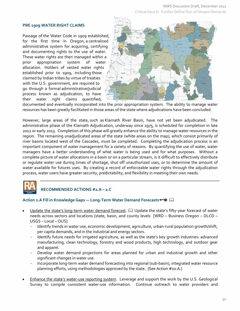
PRE 1909 WATER RIGHT CLAIMS Passage of the Water Code in 1909 established, for the first time in Oregon, a centralized administrative system for acquiring, certifying and documenting rights to the use of water. These water rights are then managed within a prior appropriation system of water allocation. Holders of vested water rights established prior to 1909, including those claimed by Indian tribes by virtue of treaties with the U.S. government, are required to go through a formal administrative/judicial process known as adjudication, to have their water right claims quantified, documented and eventually incorporated into the prior appropriation system. The ability to manage water resources has been greatly facilitated in those areas of the state where adjudications have been concluded. However, large areas of the state, such as Klamath River Basin, have not yet been adjudicated. The administrative phase of the Klamath Adjudication, underway since 1975, is scheduled for completion in late 2012 or early 2013. Completion of this phase will greatly enhance the ability to manage water resources in the region. The remaining unadjudicated areas of the state (white areas on the map), which consist primarily of river basins located west of the Cascades, must be completed. Completing the adjudication process is an important component of water management for a variety of reasons. By quantifying the use of water, water managers have a better understanding of what water is being used and for what purposes. Without a complete picture of water allocations in a basin or on a particular stream, is it difficult to effectively distribute or regulate water use during times of shortage, shut off unauthorized uses, or to determine the amount of water available for futures uses. By creating a record of enforceable water rights through the adjudication process, water users have greater security, predictability, and flexibility in meeting their own needs.
RECOMMENDED ACTIONS #2.A – 2.C
Action 2.A Fill in Knowledge Gaps — Long‐Term Water Demand Forecasts Update the state’s long‐term water demand forecast. Update the state’s fifty‐year forecast of water
needs across sectors and locations (state, basin, and county levels [WRD – Business Oregon – DLCD – USGS – Local – OUS] ~ Identify trends in water use, economic development, agriculture, urban‐rural population growth/shift,
per capita demands, and in the industrial and energy sectors. ~ Identify future needs for irrigated agriculture, as well as the state’s key growth industries: advanced
manufacturing, clean technology, forestry and wood products, high technology, and outdoor gear and apparel.
~ Develop water demand projections for areas planned for urban and industrial growth and other significant changes in water use.
~ Incorporate long‐term water demand forecasting into regional (sub‐basin), integrated water resource planning efforts, using methodologies approved by the state. {See Action #10.A.}
Enhance the state’s water‐use reporting system. Leverage and support the work by the U.S. Geological
Survey to compile consistent water‐use information. Continue outreach to water providers and
IWRS Discussion Draft, December 2011
50
Critical Issue D: Further Define Out-of-Stream Demands

stakeholders, increasing participation in the water‐use reporting process to support forecasting updates. Improve the data uploading system to make data collection more efficient for both WRD and water users. [WRD – public and private partners]
Update Oregon’s crop water use tables, using newer estimating methods. Extension agents in
Washington state are updating their crop water use tables with new models and find in most cases that less water is needed than older tables called for. [OSU Extension]
Quantify and model the economic value of water, both instream and out‐of‐stream, in Oregon. For
example, the productivity of land and crop production are increased several fold with the application of water. This expands the options of crops that can be grown, lowers the risk of impacts from weather and disease, and enables economic growth beyond the farm. This type of information is of critical importance to the U.S. Bureau of Reclamation and other major funding agencies, where economic information is needed to asses the cost‐benefit of potential water resource projects or proposals. {See Action #3.A for similar language.} [public and private partners]
Action 2.B Improve Water‐Use Measurement Strategically measure water‐use. Fully implement the Water Resource Commission’s Strategic
Measurement Strategy (2000) by “majoring on the majors.” Increase investments and partnerships in qualified staff, measuring equipment, and real‐time access to data in order to measure significant diversions in high priority watersheds. These diversions represent about 50 percent of the volume of water diverted in Oregon. Partner with the Bureau of Reclamation, Bonneville Power Administration, USDA‐Natural Resources Conservation Service, tribes and private partners. Conduct follow‐up inspections to ensure that measurement devices are properly installed and maintained. [State – Federal – Local – Tribes – private partners]
Conduct studies to determine the location and average demands of exempt well use. {See Action
#6.A.} [Universities – WRD – local agencies] Employ remote sensing technologies to better define water use in data‐limited areas. [WRD – Federal
– Local] Encourage businesses to conduct self‐evaluations of water use. The physical and legally availability of
water, world‐wide, is a continuing challenge to businesses of all kinds. Several organizations have made tools available on‐line to businesses who want to benchmark their own water use and asses the risks associated with reliance on water. The Aqua Gauge, released in October 2011, contains background information, definitions, and links to a wealth of resources for corporate use. (http://www.ceres.org/resources/reports/aqua‐gauge/view).
Action 2.C Determine Pre‐1909 Water Right Claims Complete areas of the state that have not undergone the adjudication process (see map), including
reserved water right claims that still exist for tribal or federal lands. Establish priorities for conducting surface water adjudications. [WRD – Federal – Tribes – local partners]
Settle federal reserved claims, including tribal claims, in basins that were previously adjudicated.
Establish priorities for this work. [WRD – Federal – Tribes – local partners] Settle groundwater claims. Establish priorities for this work. [WRD – Federal – Tribes – local partners]
IWRS Discussion Draft, December 2011
51
Critical Issue D: Further Define Out-of-Stream Demands

CRITICAL ISSUE E: FURTHER DEFINE INSTREAM NEEDS
Critical Issue E
Further Define Instream Needs
With more than 100,000 miles of river and streams, more than 1,400 named lakes, and approximately 1.2 million acres of wetlands, water resources contribute greatly to Oregon’s instream economy by providing recreational opportunities, serving as scenic attractions, and by supporting aquatic habitat, in which species live and thrive. Ensuring sustainable water resources is important as it provides both economic and social benefits to Oregonians. WATER INSTREAM SUPPORTS OREGON’S ECONOMY The economic contribution of fish and wildlife recreation speaks to the importance of protecting water instream. Without adequate water within the system, these uses and benefits are threatened. There are other uses too that benefit from adequate flows, such as navigation and transportation. The Columbia River, for example, is the largest wheat exporting transportation system in the nation. Water‐Related Recreation and Tourism There are many recreational activities and tourist attractions in Oregon where the focal point is a lake, river, stream, a snow‐covered mountain, or the ocean. Water resources in Oregon offer many recreational opportunities, such as boating, kayaking, rafting, canoeing, camping, hiking, fishing, and observing wildlife, which greatly contribute to Oregon’s economy. According to a national survey by the U.S. Fish and Wildlife Service, 87.5 million U.S. residents fished, hunted, or watched wildlife in 2006, spending over $122 billion and contributing to millions of jobs in industries and businesses that support fish and wildlife‐related recreation. In Oregon, a study completed by Dean Runyan and Associate looked specifically at county and state expenditures and found that, in 2008, nearly 2.8 million Oregon residents and nonresidents fished, hunted, shellfished, or watched wildlife, resulting in expenditures of $2.5 billion. These expenditures include transportation expenses, accommodations, recreational fees, food and beverage services, and equipment purchases. Many Oregon counties, such as Harney, Lake, Morrow, and Wheeler County, receive a significant boost to their local economy from those willing to travel to participate in fish and wildlife recreation activities. The economic value of fish and wildlife recreation is one of the many reasons for protecting Oregon’s water instream for continued enjoyment. Camping. There are hundreds of day‐use parks and overnight camping facilities in Oregon, many of which reside along scenic rivers and lakes. The Oregon Department of Parks and Recreation manages more than 360 properties that include day‐use areas and overnight camping facilities available for public use. In 2009, more than 2.5 million people stayed overnight and 41 million people visited day‐use areas. Oregon ranks among the nation’s top ten in state park overnight and day‐use attendance. Not only are people willing to pay to visit and stay in these parks, many Oregonians volunteer thousands of hours a year to help maintain park lands and facilities (In 2009, there were 497,537 volunteer hours). Combining visitor expenses for both state and federally managed parks, visitors spent $222 million on travel‐related expenses to use public campground facilities in 2009.
IWRS Discussion Draft, December 2011
52
Boating and Paddling. There were nearly 3 million boat‐use days during the 2007 boating season, according the Oregon State Marine Board. A “boat use day” is any portion of a 24‐hour period in which a participant is engaged in boating activities. Boaters spent 50 percent of their time on Oregon’s rivers. The Columbia, Willamette, Tillamook, Rogue and Deschutes Rivers rank in among the most used waterbodies by boaters. Although water‐related activities such as sailing, waterskiing, and wakeboarding have declined about 20 percent since 2004, non‐motorized boating (kayaking, rafting and canoeing) have continued to increase. Thirteen percent of Oregonians participated in paddling activities in Oregon in 2005, according to an Outdoor Industry Foundation report. Nationally, more Americans paddle than play soccer. Recreational Fishing. The importance of fish to Oregon’s ecology and economy cannot be overstated. Native fish such as salmon are an Oregon icon and support a vigorous recreational and industrial economy. Fishing remains the highest use activity for boaters at 63 percent of all activity days. According to the American Sportfishing Association, in 2006, there were 7 million fishing days spent by resident and non‐resident freshwater anglers and 846,000 fishing days spent by resident and non‐resident saltwater anglers. In 2006, the economic impact of sport fishing in Oregon, in both freshwater and saltwater environments, totaled more than $623 million in retail sales, supporting more than 11,000 related jobs in Oregon, and generating an economic output of more than 1 billion dollars. More Americans spend time fishing, nearly 40 million of them, than playing golf and tennis combined. Commercial Fisheries According to an ODFW briefing report on Oregon’s commercial fishing industry, more than 211 million pounds of fish were delivered to Oregon ports in 2009. The harvest value of Oregon onshore landings was $104.4 million. The estimated total personal income generated by the Oregon commercial fishing industry (onshore and distant water fisheries) in 2009 was $398 million, which supports thousands of jobs each year. The Dungeness crab fishery dominates the commercial fishing industry, accounting for more than 40 percent on the onshore landing harvest value. The commercial fishing industry supports a number of communities along the Oregon Coast (Astoria/Warrenton, Garibaldi, Depoe Bay, Newport, Winchester Bay, Coos Bay/Charleston, Port Orford, Gold Beach and Brookings). In some towns, commercial fisheries provides a quarter or third of all the annual earned income. The industry supports a cluster of fish processing plants, mechanics, machine shops and welders, refrigeration specialists, marine electronics sales and service firms, and marine suppliers. WATER INSTREAM IS NEEDED FOR ECOSYSTEM HEALTH Along with supporting the economy, water is needed within the environment to ensure overall ecosystem health. Some ecosystems, such as springs, and some rivers, lakes, and wetlands depend on the discharge of groundwater to the surface. By comparison, other ecosystems such as forests, riparian areas, and some types of wetlands are dependent upon water tables that lie close to the surface. Aquifer and subterranean ecosystems are reliant on groundwater further below the surface. Stream Conditions There are certain stream conditions that are necessary to support the life cycle of fish species. The need for certain stream conditions varies by species. Coho, for example, need gravels that are clean with various sizes to create nests and deposit their eggs. Coho prefer to spawn and rear in small, relatively flat streams. Cool water is a requirement for rearing, as well. Wetlands, off‐channel ponds, and other slackwater areas provide small fish (fry) with safe areas to reside in during the winter season when the current is swift. The complexity of the habitat, which includes both large and small woody debris, directly contributes to the health and function of salmon bearing streams.
IWRS Discussion Draft, December 2011
53
Assessment of Groundwater‐Dependent Ecosystems
‐ Allison Aldous and Leslie Bach, The Nature Conservancy
Groundwater is a vital source of water that sustains both ecosystems and human communities worldwide. Wetlands, rivers, and lakes often receive discharge from groundwater; it provides late‐summer flow for many rivers, and creates cool‐water upwellings critical for aquatic species during the summer heat. The species and habitats that rely on this source of water for some or all of their life cycle are known as groundwater‐dependent ecosystems, or GDEs. These ecosystems form the interface between groundwater and surface water, and due to their unique hydrology, they often harbor many rare and endemic species (Stevens & Meretsky 2008). A recent study found that 17 percent of species listed under the U.S. Endangered Species Act were groundwater‐dependent (291 species); that percent rises to 27 percent when considering invertebrates alone (Blevins & Aldous 2011). Thirty‐four of the 291 listed species (12 percent) are found in Oregon. However, these numbers probably are low because inventory of GDEs in Oregon and elsewhere is limited. Groundwater‐dependent ecosystems contribute to human well‐being through ecosystem services, such as water storage and purification. However, groundwater use is increasing, particularly where surface water supplies are depleted and contaminated, and surface flows are becoming less predictable as the climate becomes more variable. More water pumped from the ground to meet human needs means less water to support GDEs and their benefits to human communities. Furthermore, groundwater contamination by nutrients and chemicals poses risks to both drinking water supplies and groundwater‐dependent biodiversity. Oregon GDE Assessment Despite a general understanding of these issues, there are limited data describing the distribution and extent of GDEs in Oregon and the problems they face. Data layers for aquatic ecosystems do not directly describe the link to groundwater, and basin groundwater studies are not conducted at a scale to specifically address GDEs. To address this gap, The Nature Conservancy published a statewide assessment of GDEs in Oregon (Brown et al. 2009; 2010). The assessment includes numerous maps of the distribution of groundwater‐dependent ecosystems such as wetlands, springs, and lakes, as well as potential threats to their groundwater quality and quantity. Not surprisingly, the highest densities of GDEs in the state are found in basins such as the Deschutes, Klamath, John Day, and Willamette, as well as along the High Cascades both east and west of the crest. Flow in perennial streams is significantly supported by groundwater in 40 percent of 6th field Hydrologic Unit Code watersheds (HUC6s) across the state. With nearly 32,000 mapped springs, the literature shows Oregon as the state with the highest density of springs in the western U.S. (Stevens & Meretsky 2008). The coarse scale statewide assessment is just a first step in identifying GDEs. Specific data are needed at the basin scale to identify more precisely the location and extent of GDEs. The Nature Conservancy has been assisting the U.S. Forest Service with a series of protocols for inventorying and monitoring GDEs on National Forests and Grasslands. These protocols were tested in the Blue Mountains as part of a nationwide pilot project, and several forests in Oregon plan to inventory GDEs in the coming years. Along with the protocols, the Nature Conservancy and the Forest Service are working on updating technical guidance for addressing activities that affect GDEs in the National Forests, including the Forest Service’s Technical Guide to Managing Groundwater Resources (2007). The Conservancy is also working to improve the resolution of GDE mapping at a finer scale. In the Deschutes Basin, we are testing out methods for identifying GDEs remotely using imagery such as from the National Agriculture Imagery Program (NAIP) and Light Detection and Ranging (LiDAR). As the state identifies resources to fill data gaps in our understanding of the relationship between groundwater and surface water, GDE
IWRS Discussion Draft, December 2011
54
mapping and characterization need to be included. Determining Groundwater Requirements for Ecosystems Incorporating ecosystem requirements into decision‐making is an important component of conjunctive groundwater/surface water management. To achieve this, tools and methods are needed for determining the amount and timing of groundwater flow required to support GDEs and how those needs interact with groundwater extraction for human uses. The Nature Conservancy has been working with the US Forest Service to develop methods for quantifying groundwater requirements for ecosystems in Oregon, which may ultimately be applied across the National Forest System. This process has been termed “Environmental Water Requirements.” Our first project is in the Fremont‐Winema National Forest, where water is extracted from groundwater‐dependent wetlands to provide water for cattle on a grazing allotment, potentially drawing down the water table beyond the tolerance threshold of plants and animals. Once the methods are complete, we will work with the Forest Service and other water managers on a voluntary basis to balance water allocations among other users. This type of approach will be important as additional groundwater needs arise across the state. Water Policies There are some significant gaps in state and federal groundwater policies across the country (described in more detail in Aldous & Bach 2011). From a water quality perspective, policies are effective in protecting groundwater that is part of a drinking water system. However, these policies often ignore smaller, shallower aquifers that are important for ecosystem functions but do not contribute to drinking water supply. These GDEs can be stressed by many different types of contaminants; however, limitations to the state’s monitoring budget mean that these aquifers are not monitored for water quality. From a water quantity perspective, recent developments in groundwater policies protect flows to lotic (running) waters more than lentic (still) waters. For example, in the Deschutes Basin, new groundwater withdrawals require mitigation of surface water flows. This program protects instream flows and associated biota better than springs and non‐river‐associated wetlands. Like Oregon, Michigan also evaluates groundwater permits based on potential impacts to streamflow. By contrast, the states of Florida and Rhode Island have set minimum water levels for wetlands, not just minimum flow targets for running water. In contrast to the piecemeal approach found in the US, a trend is emerging overseas in the water policy arena, whereby freshwater ecosystems—including GDEs—are recognized as requiring certain allocations of groundwater. Adequate provisioning of water—including groundwater—is stipulated to guarantee ecosystem functioning to all aquatic ecosystems. Water policies enacted in the last decade in the European Union, South Africa, and Australia include such provisions. Next Steps GDEs and the multiple ecosystem services they provide need to be recognized and accounted for in water and land management policies. To do this, we need to fill critical data gaps in identifying GDEs and improve our understanding of the relationship between groundwater and ecosystem needs. As local governments and water managers develop water management plans, we need to identify opportunities for integrating the water needs of GDEs into the decision‐making process. Finally, protection and restoration of groundwater for GDEs must go beyond its connection to instream flows and should include protection of water flows and levels in springs, lakes, and wetlands.
IWRS Discussion Draft, December 2011
55
Base Flows and Elevated Flows Peak and ecological flows are a subset of stream flows that are directly tied to the ecology of the stream system. These flows serve several functions, such as to help maintain the physical attributes of a stream, act as behavioral triggers for aquatic species, and to overcome threats to aquatic life. Ecological flow functions in scientific literature are often grouped into the following categories:
Baseflow, such as subsistence and minimum or optimum habitat flows. These represent the low flow functions of a stream that provide minimal direct habitat for fish and other aquatic organisms. They can also represent minimal flows that are sufficient in quantity to overcome the potential for threats to aquatic life from harmful pollutants or stream heating. Biological triggering flows represent elevated streamflows that may trigger a behavior in an aquatic organism that is essential for its survival such as migration or spawning. Channel habitat maintenance flows are elevated streamflows (often flood or peak flows) that rework the channel or its streambed, rejuvenating or cleaning gravel, reforming habitat features, replenishing/rejuvenating riparian vegetation, and/or re‐establishing connectivity with off channel habitats.
An adequately protected ecological flow regime includes baseflows as well as a variety of elevated flows that provide habitat maintenance and other ecosystem functions. CONCLUSION Oregon’s ability to meet instream needs is limited by our own understanding of these needs. While we know that ecosystems and species depend upon both surface water and groundwater, we do not fully know all of the ecological functions that rely on groundwater and surface water. Nor have we fully quantified the ecological degradation that occurs with differing qualities and quantities of water. We currently lack a comprehensive understanding of the base flows needed to support fish habitat. Today, there is not much information about base flow needs for species other than the high profile salmonid species (other species being lamprey, chub, white fish, other native fish species, amphibians, macro‐invertebrates, etc.).
More information is also needed, regarding the elevated flows are necessary to maintain the physical characteristics of a stream or to trigger biological processes. Instream water rights in Oregon today have been designed to address situations of low flow and they focus almost exclusively on depth, velocity, and substrate criteria; generally, instream water rights have not focused on protecting elevated streamflows.
IWRS Discussion Draft, December 2011
56

RECOMMENDED ACTIONS #3.A – 3.B
Action 3.A Fill in Knowledge Gaps – Flows Needed (Quantity & Quality) to Support Instream Needs
Conduct Base Flow Needs Studies. Identify which streams already have base flow needs studies, then prioritize and complete those that are still needed and those that need updates. Established methods already exist for these studies. Base flows are the instream flows needed to sustain basic life stage functions and are important for maintaining habitat conditions, scenic and aesthetic values, and protecting water quality. [ODFW – WRD – DEQ – OPRD]
Develop Elevated Flow Needs Requirements. Develop criteria to determine what elevated flows are
needed in each water basin / watershed. Develop recommended flows for each water basin / watershed based on the developed criteria. The state has begun to develop methodologies in this area; information collection is still in the beginning stages. [ODFW – WRD – DEQ – OPRD]
Develop models/studies on the economic value of water, both instream and out‐of‐stream, in Oregon. This information is of critical importance to agencies like the U.S. Bureau of Reclamation, Oregon Watershed Enhancement Board, and other major funding agencies, where economic information is needed to asses the cost‐benefit of potential water resource projects or proposals. {See Action #2.A for similar language.} [public and private partners]
Action 3.B Fill in Knowledge Gaps – Needs of Groundwater Dependent Ecosystems Identify and characterize groundwater‐dependent ecosystems statewide, using the U.S. Forest
Service and The Nature Conservancy’s 2011 inventory as a basis. Determine where and how much inflow comes from natural springs, compared to artificial contribution (i.e., leaky pipes, artificial recharge, etc.). Evaluate the water quality effects, including cooling, this inflow has on spawning activity, surrounding ecosystems, and downstream areas. [public and private sector]
Complete Groundwater Studies. {See Action #1.A.} [ WRD – USGS]
IWRS Discussion Draft, December 2011
57
PART III — OBJECTIVE: Understand Coming Pressures
IWRS Discussion Draft, December 2011
58

CRITICAL ISSUE F: THE WATER & ENERGY NEXUS
Critical Issue F
The Water and Energy Nexus
The water‐energy nexus refers to the close relationship between water and energy, in terms of producing and using each resource. To date, the connection between the use of water and its relationship to energy has largely been unaddressed in water policy, studies, or planning exercises in Oregon. With the Integrated Water Resources Strategy and new efforts to develop a 10‐year Energy Plan, Oregon policy‐makers have a good opportunity to better connect these two resources, designing a system where both resources are managed in a sustainable way. ENERGY NEEDS IN THE WATER INDUSTRY The United States uses a tremendous amount of energy to deliver water to where it is used. The amount of energy used to pump, treat, and heat water accounts for at least 13 percent of the nation’s total electricity use, according to The River Network, a Portland‐based organization focused on watershed protection. The amount of money Oregonians pay for energy can be partly attributed to water use. According to the Oregon Department of Energy, heating water accounts for 15 to 25 percent of a typical home’s energy bill. For a municipality, the energy costs for managing water and wastewater can represent one‐third of the total energy bill. The U.S. Environmental Protection Agency estimates that U.S. drinking water and wastewater facilities annually spend about $4 billion on energy costs alone.
Achieving Energy Independence at Wastewater Treatment Plants
Excerpts from the Energy Trust of Oregon, “Achieve Energy Independence,” July 2010
Providing wastewater services requires energy, and a lot of it. Oregon wastewater utilities use approximately five percent of the state’s electricity, and energy accounts for about 15 percent of a typical domestic wastewater treatment plant’s operating budget. It’s not uncommon for wastewater treatment to be one of the largest municipal energy loads in a community. The good news is that energy represents the largest controllable cost of providing wastewater services to the public. With today’s technologies, it is feasible for a wastewater treatment plant’s annual energy budget to approach zero, by optimizing energy efficiency and taking advantage of renewable resource opportunities. The Energy Trust of Oregon is partnering with wastewater treatment facilities here in Oregon to trim energy use with new pumps, drives, motors, and other energy efficient equipment. From there, plants can produce renewable energy of their own by taking advantage of digester gas or other renewable resources. Wastewater treatment plants that use anaerobic digestion produce methane—a source of renewable energy. Methane can be used to directly offset the plant’s use of natural gas or through cogeneration—the production of both electricity and heat to meet facility energy needs. The Energy Trust offers help with feasibility studies, technical assistance and cash incentives, to help plant operators get started. Already, treatment plants in the Cities of Pendleton, Mosier, Cottage Grove, Portland, and Clean Water Services in Washington County have made money‐saving energy gains through this program.
IWRS Discussion Draft, December 2011
59

WATER NEEDS IN THE ENERGY INDUSTRY Just as we need energy in order to use water, we also use water to produce energy. Natural gas and coal facilities require water for cooling towers; bioenergy systems rely on water to grow fuel crops; geothermal systems use groundwater as a medium for heat; and of course hydroelectric and wave energy facilities are powered by the movement of water. While some of these uses are not consumptive, water is essential to their success. Developing renewable power systems in order to achieve a cleaner energy mix and new economic opportunities brings with it as‐yet‐unquantified demands for water. An analysis of water demands in each energy sector would provide a better scientific understanding of the state’s future water commitments. In 2011, the Oregon Legislature modified the state’s hydroelectric statutes, allowing wave energy pilot projects to connect to the power grid and recoup their investments. These projects must be less than five megawatts in size and meet other requirements spelled out in statute. This provision will sunset in 2022. In the Pacific Northwest, hydropower is especially important for meeting energy needs. According to the Northwest Power and Conservation Council, forty percent of the electricity used in the Northwest is generated at federal dams in the Columbia River Basin. In an average year, these dams generate 8,664 megawatts of electricity, or enough power for approximately 4.9 million homes (at 570 homes per megawatt). Expanding Oregon’s Hydroelectric Portfolio According to the State of Oregon Energy Plan, new growth in the hydropower sector is most likely to occur in three areas: pumped storage, the addition of power facilities onto existing dams, and the addition of power into existing irrigation systems. Pumped Storage Systems. A pumped storage system consists of two reservoirs, one at a higher elevation than the other, in which water moves down to the lower reservoir to generate power when demands are high; and then water is pumped back up to the higher reservoir when prices and demands are low, usually at night. Pumped storage systems are not considered to be a renewable power source. They operate at a net power loss. But, because of the balancing services they provide to the grid, they can be considered a power management tool or an energy storage device. These plants can operate at any size, but most proposals are very large – around 1,000 megawatts (MW). (By comparison, Bonneville Dam has a capacity of 1,189 MW.) There are several pumped storage proposals, but no developed projects yet in Oregon. The proposals are located near high‐voltage transmission or already‐existing water infrastructure. Adding Hydroelectric Capability to Existing Infrastructure. The face of hydropower is changing as smaller projects become a part of the renewable energy mix. New technology provides the opportunity to install small hydroelectric systems within existing infrastructure. Incentive programs and policy initiatives have enhanced the ability for small projects to be developed more quickly than larger hydropower facilities of the past. The Northwest Power and Conservation Council’s Fish and Wildlife Plan precludes new hydropower development on many streams in the Northwest, unless the project can be developed at an existing diversion or within the infrastructure beyond the diversion. The Federal Energy Regulatory Commission (FERC) authorizes two types of exemptions that can be approved in a much shorter time frame than a standard license: 1) “exemption” projects added to existing dam structures with a capacity of five megawatts or less; and 2) “conduit exemptions.” Conduit exemptions are power generation projects that occur within or at the end of a pipeline or conduit beyond the original diversion. A conduit may be an open canal or a pipeline in an irrigation district, a pipeline in a municipal water or wastewater system, or a pipeline within an industrial operation.
IWRS Discussion Draft, December 2011
60

One of the policy changes that enabled a more expedited process for these smaller exempt projects resulted from the Oregon legislature’s enactment of HB 2785 in 2007 (currently ORS 543.765). Holders of water right certificates under those provisions can secure approval to install hydroelectric generation inside or at the end of already‐existing transmission pipelines or conduits. This process mirrors the simplified Federal Energy Regulatory Commission (FERC) applications for exemptions from the licensing process. This expedited state approval process leverages the ability to use existing water rights and infrastructure to provide an added renewable energy benefit as well as efficiencies and a return on investment for the applicant. The statute requires that the schedule of water use, amount and conditions applicable to the original beneficial purpose must remain the same as identified in the original right. The resulting hydroelectric water right certificate will include the Oregon Department of Fish and Wildlife’s requirements for fish screens, by‐pass devices, and fish passage. Other policies initiated in Oregon support hydropower renewable development, including the Renewable Portfolio Standard that requires the largest utilities to purchase a specific amount of energy from newer, clean, renewable sources of energy. The marketplace for Renewable and Tradeable Energy Certificates (RECs and TRECs) also drives the development of these small projects.
Conduit Hydroelectric Projects: A View from Irrigated Agriculture in Central Oregon
‐ Kevin Crew, Black Rock Consulting
Over the last eight years, there has been a resurgence of hydroelectric power generation interest in the irrigation and agriculture communities in the Central Oregon region, reflecting a region‐wide trend. Hydroelectric power production, a renewable energy resource has provided electrical generation for more than 150 years. Most of these projects have a life of 50‐100 years and do not require a fuel source. Some hydroelectric power projects exist at dam facilities across the state and others can be added to existing non‐powered dams, both at federal facilities and upon district‐ owned facilities. Because these projects are “existing diversions,” they can be developed as expedited “exemptions” from licensing under the Federal Energy Regulatory Commission process. Current technology provides the opportunity to go beyond the existing diversions to establish other small hydroelectric facilities within the irrigation system itself. These smaller projects, located within existing irrigation district systems and canals, are approved under a simplified, short‐term process (duration of six months’ time on average) with a “conduit exemption” from FERC licensing. There has been a renewed interest in renewable energy development, resulting in federal, state and private incentive programs over the past decade. Oregon programs include the Business Energy Tax Credit (BETC), the Small Scale Energy Loan Program (SELP), the Community Renewable Energy Feasibility Fund (CREFF), and funding from the Energy Trust of Oregon from investor‐owned utility support funds. Federal programs include the renewable electricity “production tax credit” (PTC), the business energy investment tax credit (ITC) , innovative grants from the U.S. Department of Energy, and the Department of Energy Loan Guarantee Program, as well as the USDA Rural Energy Loan Program (REAP) and Clean Renewable Energy Bonds (CREBs) for government entities. Some of these incentives have encouraged and enabled irrigation districts to install conduit hydroelectric projects within their existing infrastructure. Black Rock Consulting, based in Bend, Oregon, has been involved in evaluating more than 50 potential irrigation district‐related hydroelectric power generation sites under a study grant from the Energy Trust of Oregon. The study analyzed 30 of these sites in depth, noting elevation differentials, flow rate data, conceptual hydropower systems size, and potential costs, and revenue estimates. The study identified sites
IWRS Discussion Draft, December 2011
61

with power potential generally in excess of 0.5 Megawatts (MW) and also identified a total potential of approximately 22 MW from both projects at existing dams (exemptions) and projects within the infrastructure (conduit exemptions). Some of the conduit projects identified are now being reviewed under feasibility analyses, and some, like the three highlighted below, have already been completed.
with power potential generally in excess of 0.5 Megawatts (MW) and also identified a total potential of approximately 22 MW from both projects at existing dams (exemptions) and projects within the infrastructure (conduit exemptions). Some of the conduit projects identified are now being reviewed under feasibility analyses, and some, like the three highlighted below, have already been completed. Central Oregon Irrigation District. Black Rock Consulting recently completed professional services for the ($26 million) 3.8 MW Central Oregon Irrigation District Juniper Ridge Hydroelectric Power Generation Facility, which began full power production in 2011.
Central Oregon Irrigation District. Black Rock Consulting recently completed professional services for the ($26 million) 3.8 MW Central Oregon Irrigation District Juniper Ridge Hydroelectric Power Generation Facility, which began full power production in 2011. Central Oregon Irrigation District Juniper Ridge Project
Black Rock Consulting was also involved in the Black Rock Consulting was also involved in the implementation of the new Swalley Irrigation District 0.75 Megawatt hydroelectric power plant located in Central Oregon near Bend. The Blue Lake (Camp Caldera) Hydropower Site features a 20 horsepower project with Fish Screening and Passage Design. This unique project involves a fish screen that meets the Department of Fish and Wildlife’s passive cleaning criteria. The fish passage at the project is a unique stainless steel design developed using the insight of renowned sculptor, Lee Kelly. The project has won several engineering excellence awards both in Oregon and nationally and has presented a viable alternative to traditional concrete ladders.
Blue Lake Hydropower Site with Fish Passage and Screeningand ScreeningMost of the hydro projects in the irrigation districts of Central Oregon placed conserved water instream as the result of piping open canals. The districts have permanently placed 40 cfs of senior water instream, through the State’s Allocation of Conserved Water Program, in exchange for public funding to help purchase pipe. Challenges There are four significant challenges to in‐conduit hydroelectric power generation projects in Oregon. The first challenge is economic. The power rates paid to energy producers in Oregon are substantially lower than in most states, and payments are projected to continue to decline on a per kWh basis. Additionally incentive programs such as the Oregon Business Energy Tax Credit (BETC) are instrumental to project funding, and have historically provided about 33 percent of project capital costs. However, funding for these programs continues to decrease, commensurate with reductions in the state budget. The second challenge is local zoning. Since hydroelectric power generation is seeing a resurgence in Oregon, local agencies have found themselves trying to address this in their procedures, policies and codes. Proposed
IWRS Discussion Draft, December 2011
62

projects must navigate through existing systems, relying on interpretations of already existing local codes. Few projects are deemed an “outright use” in zones within which they are located. Some zones preclude the installation of hydroelectric power all together, depending upon the jurisdiction. This challenge could be met in the future by adjusting statewide goals for renewable energy development and associated zoning code updates in the various local jurisdictions. The third challenge is the cost associated with required fish protections. This process involves the modification of an already‐existing water rights certificate, allowing the State Department of Fish and Wildlife to condition the right with fish screens, by‐pass devices, and fish passage. These fish protection measures may even be required for river or creek intakes that are far removed from the in‐conduit hydroelectric power project. The requirement of such costly improvements has prevented some hydroelectric power projects from further consideration. The fourth challenge to in‐conduit hydroelectric power projects is the electric utility interconnect process. Each interconnect is unique and each utility addresses the interconnection process differently. This can cause uncertainty in project schedules, greatly increasing project costs. Additionally, when projects are in co‐operative areas, specific wheeling charges or unique interconnection requirements may also be applied. In the case of one cooperative, the wheeling charge established was applied year round even though the power generation was scheduled within a six‐month timeframe. This has stopped several projects from further consideration until financial conditions change. GAINING WATER & ENERGY EFFICIENCIES The Alliance for Water Efficiency (AWE) and the American Council for an Energy Efficient Economy (ACEEE) recently published a “blueprint for action” that identifies ways to gain efficiencies in both water use and energy use. They found that, for the past 30 years, strategies to conserve energy and increase the efficiency of energy use have been widely pursued. Similar efforts in the conservation and efficient use of water have occurred over the past twenty‐plus years. However, the two communities have historically not worked together in a coherent, collaborative manner, and instead, have created separate but parallel efforts. ACE and ACEEE developed the blueprint hoping that significant benefits could be realized from coordinating efforts. Saving Water & Energy through Building Codes Recognizing the connection between water and energy can lead to savings in both sectors, especially during new building construction or remodeling. Oregon has statewide mandatory building codes in 11 different specialty areas, including plumbing and energy. The state’s codes are based on national model codes and are updated on three‐year cycles. They establish minimum requirements for all commercial and residential construction in the state. To provide guidance to local jurisdictions on water conservation, the State of Oregon Building Codes Division (BCD) approved Statewide Alternative Methods (SAMs) on rainwater harvesting (applies to both commercial and residential construction as well as potable and non‐potable uses) and using graywater for flushing toilets. BCD also published a series of ‘Oregon Smart Guides’ for consumers, two of which focus on rainwater harvesting and water conservation systems. In 2009, Senate Bill 79 directed BCD to develop a “reach code,” an optional set of construction standards for achieving greater energy efficiency than if a building were constructed under the statewide mandatory codes. Because pumping and treating water and wastewater uses energy, BCD opted to include water conservation measures in the Reach Code. The Oregon Commercial Reach Code (OCRC), which became effective July 1,
IWRS Discussion Draft, December 2011
63
2011, contains provisions from the IAPMO (International Association of Plumbing and Mechanical Officials) Green Plumbing Code that are more stringent than the 2011 Oregon Plumbing Specialty Code. The Oregon Residential Reach Code, which became effective October 1, 2011, allows site‐built composting toilets. Saving Water & Energy within Agriculture Agriculture in Oregon is also looking for ways to save energy and water. The 2011 Industry Report from the Oregon Board of Agricultures describes an upward trend in the number of Oregon producers adopting changes resulting in energy and cost savings; 4,982 Oregon farms reported making changes in the past five years to their equipment or management practices that reduced energy use or conserved water. Although there is no published state‐level inventory of agricultural electrical consumption by kilowatt‐hour, Oregon growers reported about $49 million for electricity costs in 2008 related to pumping irrigation water. The water came from about 21,000 pumps serving approximately 1.8 million acres. Oftentimes, the ability to reduce the demand for energy will also result in significant savings in the water sector, and vice versa. This is particularly true when systems are pressurized, either because the irrigation district has already piped its canals, or because the irrigator has to pump water from its source. In fact, many water efficiency programs are driven primarily by energy efficiency goals, such as the Energy Trust’s irrigation efficiency incentives and the “Save Water, Save Energy” program offered by some BPA‐affiliated energy providers. On the other hand, when water systems are not already pressurized, achieving greater efficiencies in water application—for example moving from flood irrigation to drip irrigation—may simultaneously increase the demand for energy and may drive up energy costs substantially. In this example, more efficient water techniques drive up energy use because of the need to pressurize water delivery systems. Similarly, while re‐using water may decrease the volume of water diverted, it may then drive up energy costs related to water quality treatment. Saving Water & Energy within the Home Many of the appliances featured in energy efficiency rebate programs often have water saving benefits as well. These include Energy Star‐rated clothes washers and dishwashers. The Energy Trust of Oregon offers a number of energy saving incentive programs for homes and businesses. Several of Oregon’s water providers offer water saving incentive programs to their customers. Co‐marketing these programs, and capturing both the energy and water‐savings data is important information for the design of energy and water efficiency programs in the future. In recent years, water providers in the Portland metropolitan area have partnered with the Energy Trust of Oregon and Portland Gas and Electric to offer co‐audits that identify both water and energy savings.
RECOMMENDED ACTIONS #4.A – 4.C
Action 4.A Analyze the Effects on Water from Energy Development Projects & Policies
Analyze the water demands of current and proposed water‐intensive energy development projects.
Some potential energy resources could result in significantly increased water demands. Water‐intensive energy sources can include bio‐energy, geothermal, solar thermal, natural gas, and hydroelectric projects. [Universities – DOE – WRD ‐ OBDD]
Action 4.B Take Advantage of Existing Infrastructure to Develop Hydroelectric Power
IWRS Discussion Draft, December 2011
64

Add power generation facilities to already‐existing infrastructure (e.g., pipes, canals, wells), through the use of the state’s expedited permitting process. This allows water right holders with certificated water rights to add hydroelectric capacity onto existing, durable, infrastructure, as long as water right holders meet certain conditions for fish protection, as required by the State Department of Fish and Wildlife. [Private partners – Local communities – WRD – DOE ‐ ODFW – Federal ]
Action 4.C Promote Strategies that Increase/Integrate Energy & Water Savings
Encourage communities to look for and integrate ways to conserve both energy and water {See Action #10.A}.
~ Continue to implement and evaluate building codes that improve water and energy efficiency. In
Oregon, these are the Statewide Mandatory Building Codes, the 2011 REACH Code, and the Statewide Alternate Method to Oregon building codes.* [DCBS – Local]
~ Strengthen the coordination / promotion of existing water and energy conservation programs {See
Action #11.A}. ~ Partner with water users to find and promote optimal combinations of on‐site water and energy
efficiencies. [State – Federal – Universities – private sector] Partner with Oregon’s 10‐Year Energy Plan to promote conservation strategies for water and energy.
[DOE – WRD – private sector] Ensure that energy efficiency programs capture and publicly report both water and energy savings data.
[ODOE — Energy Trust of Oregon — Bonneville Power Administration — ODA — IFA] Move toward energy independence for publicly operated treatment works (wastewater treatment
plants). Encourage greater energy efficiencies and renewable power production at wastewater treatment facilities, whose operations are energy intensive, representing significant costs in purchased electricity. Partner with energy companies to encourage the re‐use of biogas, install solar panels, and improve energy efficiencies. [Energy Trust of Oregon – Association of Clean Water Agencies – ODOE – federal and local partners]
IWRS Discussion Draft, December 2011
65
Critical Issue F: The Water & Energy Nexus
CRITICAL ISSUE G: CLIMATE CHANGE
Critical Issue G
Climate Change
The consensus among climate scientists is that climate shift is occurring and that significant impact to the environment will be felt in this century. An analysis of the global climate models used in the 2007 Intergovernmental Panel on Climate Change (IPCC) assessment show an increase in annual average air temperatures in the Pacific Northwest through the end of the 21st century. An increase in average air temperatures has potential consequences for Oregon’s water resources. Oregon’s wetlands, estuaries, rivers, and streams – even groundwater – are all affected by changes in climate. Oregon’s forest ecosystems, essential for storing and filtering water, will also be affected by climate change. These changes will have implications for both instream and out‐of‐stream water needs. Oregon will need to continuously monitor climate change effects on Oregon’s water resources and help water users adapt to climate change.
STUDIES AND PARTNERSHIPS Many institutions at the local, state, and federal level are conducting climate change research, identifying and assessing risks and actions specific to the Pacific Northwest. Many of Oregon’s drainage basins have been the focus of latest research efforts. In 2010, for example, teams of researchers from Oregon State University, University of Oregon and Portland State University began evaluating how climate change, population growth, and economic growth will alter the availability and the use of water in the Willamette River Basin on a decadal to centennial timescale. Below are some examples of institutions within Oregon working on climate change research and adaptation strategies. Oregon Climate Change Research Institute (OCCRI) The Oregon Climate Change Research Institute (OCCRI) has been tasked by the Oregon Legislature to foster climate change research among faculty of the Oregon University System. OCCRI/Oregon State University was recently awarded a grant, which could surpass $3.5 million, from the National Oceanic and Atmospheric Association to address climate assessment needs for businesses, state and federal agencies, municipalities, tribal leaders and non‐governmental organizations in the Pacific Northwest. In 2010, OCCRI released the Oregon Climate Assessment Report, which is a compendium of the relevant research on climate change and its impacts on the state of Oregon. The report draws on a large body of work on climate change impacts in the western U.S. from the Climate Impacts Group at the University of Washington and the California Climate Action Team. The report identifies knowledge gaps and the need for more research in certain areas. The Climate Leadership Initiative (CLI) For the past four years, the Climate Leadership Initiative has been implementing a series of Climate Future Forums and Watershed Resiliency Trainings across Oregon’s river basins. The goal of these programs is to develop models for building climate resiliency and adaptation literacy, while also delivering the tools and resources needed to assist all levels of governments, the private sector, and non‐profits to proactively prepare for climate change. The Climate Leadership Initiative is a social science‐based research and technical assistance collaborative between The Resource Innovation Group and the Institute for a Sustainable Environment at the University of Oregon.
IWRS Discussion Draft, December 2011
66
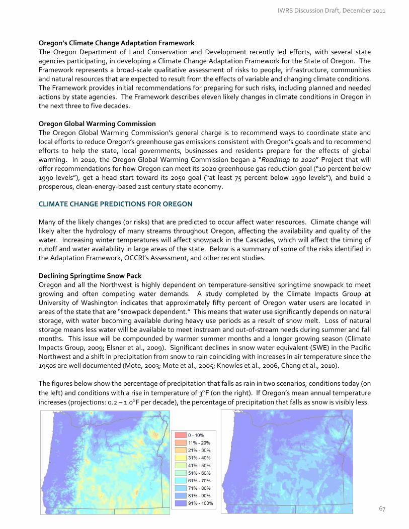
Oregon’s Climate Change Adaptation Framework The Oregon Department of Land Conservation and Development recently led efforts, with several state agencies participating, in developing a Climate Change Adaptation Framework for the State of Oregon. The Framework represents a broad‐scale qualitative assessment of risks to people, infrastructure, communities and natural resources that are expected to result from the effects of variable and changing climate conditions. The Framework provides initial recommendations for preparing for such risks, including planned and needed actions by state agencies. The Framework describes eleven likely changes in climate conditions in Oregon in the next three to five decades. Oregon Global Warming Commission The Oregon Global Warming Commission’s general charge is to recommend ways to coordinate state and local efforts to reduce Oregon’s greenhouse gas emissions consistent with Oregon’s goals and to recommend efforts to help the state, local governments, businesses and residents prepare for the effects of global warming. In 2010, the Oregon Global Warming Commission began a “Roadmap to 2020” Project that will offer recommendations for how Oregon can meet its 2020 greenhouse gas reduction goal (“10 percent below 1990 levels”), get a head start toward its 2050 goal (“at least 75 percent below 1990 levels”), and build a prosperous, clean‐energy‐based 21st century state economy. CLIMATE CHANGE PREDICTIONS FOR OREGON Many of the likely changes (or risks) that are predicted to occur affect water resources. Climate change will likely alter the hydrology of many streams throughout Oregon, affecting the availability and quality of the water. Increasing winter temperatures will affect snowpack in the Cascades, which will affect the timing of runoff and water availability in large areas of the state. Below is a summary of some of the risks identified in the Adaptation Framework, OCCRI’s Assessment, and other recent studies. Declining Springtime Snow Pack Oregon and all the Northwest is highly dependent on temperature‐sensitive springtime snowpack to meet growing and often competing water demands. A study completed by the Climate Impacts Group at University of Washington indicates that approximately fifty percent of Oregon water users are located in areas of the state that are “snowpack dependent.” This means that water use significantly depends on natural storage, with water becoming available during heavy use periods as a result of snow melt. Loss of natural storage means less water will be available to meet instream and out‐of‐stream needs during summer and fall months. This issue will be compounded by warmer summer months and a longer growing season (Climate Impacts Group, 2009; Elsner et al., 2009). Significant declines in snow water equivalent (SWE) in the Pacific Northwest and a shift in precipitation from snow to rain coinciding with increases in air temperature since the 1950s are well documented (Mote, 2003; Mote et al., 2005; Knowles et al., 2006, Chang et al., 2010). The figures below show the percentage of precipitation that falls as rain in two scenarios, conditions today (on
the left) and conditions with a rise in temperature of 3F (on the right). If Oregon’s mean annual temperature
increases (projections: 0.2 – 1.0F per decade), the percentage of precipitation that falls as snow is visibly less.
IWRS Discussion Draft, December 2011
67

Increased Incidence of Drought Drought has historically been an issue in Oregon, largely because, precipitation in the Pacific Northwest is highly seasonal. Most of the precipitation for the year falls in the period from October to March. The Pacific Northwest is prone to three types of drought: low winter precipitation, low summer precipitation and lack of snowpack due to warm winter temperatures (Bumbaco and Mote, 2010). Due to the annual variability of precipitation in the Northwest, not all drought can be attributed to climate change. However, with more winter rainfall, declining snowpack and earlier spring snowmelt as a result of increasing air temperatures, drought is likely to increase through the next century. A 2002 statewide hazard analysis found six counties ‐ Harney, Jefferson, Klamath, Sherman, Wallowa, and Wheeler ‐ ranking drought as their "number one" natural hazard concern. Gilliam County also ranked it highly. The possibility of longer and drier growing seasons and drought could result in an increased demand on groundwater resources and increased consumption of water for irrigation, which will have potential consequences for natural systems. Droughts also have negative effects on wetlands, stream systems, and aquatic habitats. Droughts can cause significant economic damage, for example, the agriculture industry may see reduced yields and quality in some crops. Droughts can increase irrigation‐related water consumption, and thus increase irrigation costs. Drought conditions can also have a significant effect on the supply of drinking water. Increasing Sea Levels, Wave Heights, and Storm Surges The coast is vulnerable to a number of climate‐related impacts. Oregon’s winter storms have been the primary factor for coastal erosion and flooding (Ruggiero, 2008). Maximum wave heights have increased significantly from the period of the late 1970s to 2005, from 9 meters to about 12 meters. Winter is the dominant season for storms that produce significant waves on the Oregon coast. There is some evidence that these storms will increase in frequency, but not intensity in the future. It is unclear if the increasing wave heights trend observed in the late 20th century will continue into the future, though the combination of the possibility of increasing storm‐generated wave heights and the likely trend of rising sea levels may present a substantial threat to the Oregon Coast (Ruggiero et al., 2010). Sea‐level rise along vulnerable coastlines will likely result in increased erosion and the loss of land. Climate change is expected to exacerbate many of the stresses and hazards facing the Oregon coastal zone. Rising sea‐levels will increase the erosion of the coast and cause loss of beaches and significant coastal land areas. A number of populated areas and towns along the Oregon coast are also at potential risk. Sea level rise also will increase the impacts of severe storm events through both wind erosion and flooding. Rising sea level and increasing storm intensity will increasingly stress infrastructure facilities built under different engineering standards. For water resources, these include water treatment plants, diversion facilities, and wastewater plants. The intrusion of salt water to those facilities built close to the coast will be a factor as well as potentially to groundwater wells that are close to the coast. Climate change impacts along the coast will not be limited to sea‐level rise. Increased wave heights during storm surges and increased frequency of intense storms are already occurring and are affecting Oregon’s coastlines, developed areas, and estuaries. Sea level rise will serve to exacerbate those impacts. More Frequent Precipitation Events & Flooding There is confidence that flooding will increase in the 21st century, particularly in areas that have a history of chronic flooding, namely, urban areas (Chang and Jones, 2010). Flooding in Oregon generally occurs due to extreme precipitation events, rapid snowmelt or rain‐on‐snow precipitation events. Extreme daily precipitation events may increase in the next few decades, but the basins where such events will occur cannot be predicted with any certainty. Damaging floods west of the Cascades tend to be associated with larger scale, more widespread events, while eastern Oregon will experience more localized, intensive events.
IWRS Discussion Draft, December 2011
68

Floods are a common and widespread natural hazard in Oregon. The National Flood Insurance Program reports that 256 communities in Oregon are prone to flooding, including all 36 counties. Oregon has seen the damaging effects of floods in recent years. The 2007 flood event had devastating effects on the community of Vernonia, damaging three of Vernonia's school buildings, destroying the wastewater treatment ponds and ruining more than 220 homes inside the city and an equal number outside the city limits. The 1996 floods resulted in a federal disaster declaration for 27 of Oregon’s 36 counties. Loss of Wetland Ecosystems and Services Sufficient scientific evidence suggests that climate change is now having and will have significant impacts on millions of coastal, estuarine, and freshwater wetlands throughout the country due to increased temperatures, changes in precipitation, and sea level rise. Available sea level rise (SLR) model predictions for Oregon wetland refuges indicate different types of impacts across different estuaries or estuarine segments. Recent analyses indicate that Bandon Marsh National Wildlife Refuge (NWR) is predicted to lose between 19 and 92 percent of its swamp by 2100, depending on the SLR scenario utilized (Clough and Larson, 2010). Wetlands are more sensitive to small changes in precipitation and temperature than other ecosystems (Erwin, 2009) and thus may be degraded or lost as a result of future climate conditions. Oregon‐specific projections of where losses will occur are not available for most wetland types. Impacts to Forest Ecosystems The U.S. Forest Service recently completed a report on the relationship between water, forests and ac climate change. The report highlights that warmer temperatures, less water, or more water can cause changes in forest vegetation and increase forest mortality (Allen et al. 2010, van Mantgem et al. 2009). For example, temperature increases have contributed to widespread outbreaks of mountain pine beetles across vast areas of the Rocky Mountains (Logan and Powell 2001). Higher summer temperatures and earlier spring snowmelt are expected to increase the risk of forest fires. An increase of insect outbreaks, wildfires, and changing species composition in forests will pose challenges for ecosystems and significant challenges for water management. Impacts to Aquatic Species The Oregon Climate Assessment Report examined, among other things, the effects of climate change on Oregon’s fish and wildlife species. The Report states that the distribution of cold‐water species will potentially shrink and become disconnected as thermal regimes in river networks warm more rapidly due to human influences and climate warming. More specifically, the projection of the effects of climate change on 57 species of North American freshwater fish indicated that 37 percent of the current locations inhabited by cold‐water fishes would not support these species over the next century (Mohseni et al., 2003). Other studies project that trout habitat in the Pacific Northwest would decline between 8‐33 percent by 2090. Salmon habitat is even more vulnerable to the effects of climate change because more of the habitat of salmon is at lower, warmer elevations. O’Neal et al. (2002) projected that suitable salmon habitat in Oregon and Idaho would shrink by 40 percent by 2090. Impacts to Water Quality Climate change effects on functioning ecosystems – our forests, wetlands, estuaries, and snow‐dominated systems – will exacerbate the water quality issues we are already facing in Oregon. For example, in estuaries with snowmelt‐dominated watersheds, increased runoff will result in warmer summer water temperatures, increased pollution, and sedimentation, all of which have negative consequences for water quality, salmonids and other estuarine and marine populations. A 2006 assessment shows high water temperature as a major water quality concern in more than 17,000 miles of Oregon’s streams and rivers today. An increase in sediment loads to a river system can affect municipal water supplies as well.
IWRS Discussion Draft, December 2011
69

Impacts to Water Quantity The change in timing and availability of water as a result of climate change may affect whether or not water users are able to utilize their water rights for the amount allowed. Less water available during the summer months may mean that junior users are more frequently regulated to meet the water needs of senior water right holders.
13333000 Grande Ronde R at Troy, OHybrid Delta A1B Scenario
R
0
1000
2000
3000
4000
5000
6000
7000
8000
Jan Feb Mar Apr May Jun Jul Aug Sep Oct Nov Dec
Str
eam
flo
w (
CF
S)
VIC Historical Streamflow
Predicted Streamflow (2080)
Sample Hydrograph
Current Current Predicted
One hypothetical example, depicted below, demonstrates how dramatically the hydrograph (measurement of streamflow) could change in one stream, due to a loss in snowpack. Where snowmelt historically resulted in high flows from April to June (red line), precipitation in the form of rain may, in the future, result in high flows from March through May (blue line). The implications of this shift could be significant for all water right holders, particularly for those who have historically relied on streamflows during June, July, August, or September. Water rights that protect water instream for a certain amount, time of year, and location may no longer be adequate due to precipitation changes, decreased snowpack, and changes in species distribution. An increase in regulation to meet senior rights, protect instream needs, and water quality could result. Water managers and users will need to look for ways to conserve, store, and re‐use water, while considering alternatives or new ways to meet needs in a changing climate.
The Willamette Valley Resiliency Compact
‐ Stacy Vynne and Roger Hamilton, The Resource Innovation Group
Local jurisdictions across the Willamette Valley are coming together to develop a Willamette Valley Resilience Compact (WVRC) among city and county governments. The purpose of the Compact is to coordinate and enhance efforts to build the resilience of the Valley’s economy, public health, and food, water, and energy supplies, in the face of natural hazards and anticipated impacts from a changing climate. The Compact is a cooperative approach led by local governments, but which engages state and federal agencies, stakeholders from the private sector, and non‐governmental organizations in order to strengthen community and regional resilience to build a sustainable future for the entire Willamette Valley. The Resource Innovation Group, a nonprofit organization based in Eugene, is facilitating this process. Recent participants in Willamette Valley surveys and workshops, which were used to develop the Compact, described some of the Valley’s emerging needs related to water and climate change. These needs included: 1) Identifying research on water storage opportunities due to projections for a significantly reduced
snowpack;
IWRS Discussion Draft, December 2011
70

2) Collaborating at a regional scale to deal with issues of flooding, such as floodplain restoration efforts, as a means of reducing economic and infrastructure impacts;
3) Developing strategies to enhance water conservation efforts among irrigators and support research on crops that survive well on minimal water;
4) Prioritizing and informing local and state water and climate research projects, such as the Willamette 2100 project, Benton‐Lane‐Linn Water Resources Study Group, the work of the Oregon Climate Change Research Institute, and Oregon’s Integrated Water Resources Strategy; and
5) Developing regional renewable energy strategies to reduce dependence on hydropower that may become less reliable in summer months.
Participants identified “constraints on water supply” and “increased likelihood of extreme flooding events” as the most major emerging issues in the Willamette Valley related to water and noted that water resources are not only essential to the Valley’s economic prosperity, but they also determine the quality of the region’s public health and enhance the viability of its food and energy supply. Respondents noted that adapting to climate‐related hazards, whether floods or drought, can only be effective on a Willamette River watershed scale. The compact emphasizes legislative solutions, funding needs, and the creation of a Willamette Valley Resilience Strategy to anticipate and help respond to public health stressors, disasters, to alleviate supply challenges in water, food, and energy, and to protect ecosystem services through state and federal partnerships. The first Summit to build support for the Willamette Valley Resilience Compact took place in Salem on December 12, 2011. City and county governments will be moving the Compact forward for adoption in 2012.
RECOMMENDED ACTIONS #5.A – 5.B
Action 5.A Support Continued Basin‐Scale Climate Change Research Efforts
Improve climate change projections at a basin scale , by continuing to collaborate with existing
organizations, institutions, and researchers. Basin‐scale data will enable Oregonians to prepare to respond to climate change. [Federal – State — Local—Universities—Tribes]
~ Collaborate with the Oregon Climate Change Research Institute and Pacific Northwest Climate Decision Support
Consortium on basin‐specific studies. ~ Continue and improve long‐term monitoring of surface water and groundwater resources, rain gages, and soil
moisture monitoring networks. Support NRCS’ expansion of the SNOTEL network. {See Action #1.A}. ~ Improve real‐time forecasting of water delivery, basin yields, monthly streamflow, flood frequency projections,
and drought frequency projections.
Develop reliable projections of basin‐scale hydrology, and apply these projections to :
~ Characterize flooding potential with precipitation arriving as rain instead of snow ~ Determine potential effects on groundwater recharge with loss of snowpack ~ Determine potential changes in timing and stream flow ~ Determine potential impacts to water quality ~ Determine potential migration of species ~ Determine potential changes in municipal and agricultural demand ~ Determine potential shifts in water‐related infrastructure needs (e.g., treatment, storage, transmission)
IWRS Discussion Draft, December 2011
71
~ Determine impacts on wetland and floodplain restoration efforts
Action 5.B Assist with Climate Change Adaptation and Resiliency Strategies Provide support to communities to incorporate climate change into their planning decisions. Help Oregon
communities prepare for the effects of variable and changing climate conditions, particularly sea‐level rise, storm surges, flooding, landslides, wildland fires, and drought. Partner with emergency preparedness community and potential funders, including public health and safety interests. {See Action #10.A} [Federal – State — Local—Tribes]
Analyze how instream and out‐of‐stream water rights will fare with hydrologic changes . Climate
change will likely have an impact on streamflows in many basins, which will in turn affect holders of both instream and out‐of‐stream water rights. Analyze these potential effects at the local level, and build alternatives into regional water plans {See Action #10.A and #11}. [OUS – WRD – ODFW – local government – private business]
Analyze how water rights will fare with changing crop needs . Determine the likely evolution of crops
under various climate change scenarios in Oregon. Determine changes in growing seasons and agricultural water needs, by updating Oregon’s 1999 Crop Water‐Use and Irrigation Requirements report (See http://extension.oregonstate.edu/catalog/pdf/em/em8530.pdf). [OUS – OSU Extension – private business]
Use the U.S. Environmental Protection Agency’s Climate Ready Water Utilities (CRWU) Program as a
resource for water providers to develop and implement long‐range plans that account for climate change impacts. (See http://water.epa.gov/infrastructure/watersecurity/climate/index.cfm). [Federal – State — Local—Tribes]
Increase ecosystem resiliency to climate change by protecting and restoring wetlands, alluvial floodplains,
riparian zones, uplands, and forests. Increased resiliency improves (1) the capacity for natural storage of water and carbon, (2) survival rates of aquatic species, (3) protection of cold water resources, and (4) late‐season streamflows. {See Action #12.D} [Federal – State — Local—Tribes]
Ensure continued water and wastewater services in a changing climate, by improving storage and
transmission capacity, building in system redundancy (back‐up supplies, intergovernmental agreements), and pursuing water conservation, re‐use, and efficiency projects {See Actions #7 and #11}. [Federal – State — Local—Tribes]
IWRS Discussion Draft, December 2011
72
CRITICAL ISSUE H: THE WATER AND LAND ‐USE NEXUS
Critical Issue H
The Water and Land‐Use Nexus
Oregon’s statewide land‐use planning program was designed to foster livable and sustainable development; to protect farms, forestlands and other natural resources; to conserve coastal and ocean resources; and to improve the well‐being and prosperity of Oregon’s citizens, businesses, and communities. Originating in 1973 under Senate Bill 100, the program has positioned Oregon as a nationally recognized leader in the arena of land conservation and development.
LAND‐USE PLANNING GOALS With all of its implications for water resources, land‐use management is a function that resides with local planners, local planning commissions, boards, and councils, all of which include a public process and oversight from the Department of Land Conservation and Development. These local governments are responsible for implementing their own Comprehensive Land Use Plan that complies with the 19 statewide planning goals. The Land Conservation and Development Commission will “acknowledge” a local government’s comprehensive plan when it complies with the 19 statewide planning goals. Goal 5. Many of these planning goals relate to protecting and maintaining water resources, both quantity and quality. For example, Goal 5 requires protecting state‐designated areas with known water supply or water quality issues, along with protecting wetlands and significant riparian corridors. Specifically, Goal 5 and its administrative rules require local governments to protect, among other things, “significant natural resources.” These include (1) critical groundwater areas and restrictively classified areas designated by the Oregon Water Resources Commission and (2) certain wellhead protection areas. Few local governments have completed this planning, particularly since completing the process for wellhead protection areas is not mandatory. Continuing to protect natural resources will become more important and challenging with expected population growth in Oregon. Some areas in the state that are seeing a growth in population are also areas with known water resources issues. Many of the state’s groundwater restricted areas fall within portions of Marion, Polk, Yamhill, Washington, and Clackamas counties, all of which saw a population increase of at least 10 percent since 2000. With a population of about 62,000 in 1980, Deschutes County is now home to nearly 158,000 people, many of whom reside within the upper Deschutes Basin where future groundwater use has been limited to protect existing water users, including scenic waterway flows and
19. Ocean Resources 18. Beaches and Dunes 17. Coastal Shorelands 16. Estuarine Resources 15. Willamette River Greenway 14. Urbanization 13. Energy Conservation 12. Transportation 11. Public Facilities and Services 10. Housing
8. Recreational Needs 9. Economic Development
6. Air, Water and Land Resources Quality
7. Areas Subject to Natural Hazards
5. Natural Resources, Scenic and Historic Areas, and Open Spaces
4. Forest Lands 3. Agricultural Lands
1. Citizen Involvement 2. Land Use Planning
The 19 Statewide Planning Goals
IWRS Discussion Draft, December 2011
73

instream water rights. Planning for future development must take into account current pressures on Oregon’s water resources, in terms of both water quantity and water quality. Goal 6. Goal 6 is aimed at maintaining and improving the quality of the air, water, and land resources of the state. This goal has no implementing rules. Although the goal directs local governments to consider the effects of land use on water quality, it does not contain specific requirements on how to achieve this aim. Goal 11. Goal 11 and its administrative rules require cities with a population greater than 2,500 to prepare public facilities plans addressing drinking water, wastewater disposal and treatment, and stormwater management needs. These plans focus on the costs and timing of infrastructure needs and coordination among providers within the jurisdiction. There are also goals that can indirectly affect water resources, such as development restrictions on forests lands and agricultural lands. Development on forestlands is limited by Goal 4 and county regulations. Forests encompass a large part of many of Oregon’s watersheds, particularly in the upper reaches. Limiting land uses that could have a detrimental effect on water quality is one of the purposes of restrictive forest zoning.
CHANGING LAND USES
According to the Oregon Department of Agriculture, roughly 17.1 million acres, or 28
percent of Oregon's land mass, are in agricultural production. The most highly
productive farmland in Oregon is also where most Oregonians live —the Willamette Valley.
Almost half of Oregon is classified as forestland. Sixty percent of Oregon’s forestland is managed by the federal government—approximately one quarter of Oregon’s total land base. Forests in Oregon today, however, are at risk of being fragmented, converted to other land uses, and encroached upon by development. According to the 2000 State of the Environment Report, approximately 80 percent of the once abundant riparian, bottomland forest in the Willamette Valley has been converted to agricultural and urban land uses. Oregon is seeing a significant shift in land uses on private forest land toward more developed uses. The U.S. Forest Service and the Oregon Department of Forestry recently released a study that found 586,000 acres in
Oregon changed from forest, agricultural and range uses to low‐density residential or urban uses between 1974‐2009. Statewide, the largest periodic change in area of land in a forest, range, or farm use on private land was the loss of 141,000 acres from intensive agriculture use between 1974 and 1984. Of this loss, 100,000 acres shifted to low‐density residential use.
The Oregon Department of State Lands recently completed a study with the U.S. Fish & Wildlife Service on wetland and land use change in the Willamette Valley. From 1994 to 2005, the Willamette Valley continued to experience wetland losses. In 2005, the Willamette Valley contained an estimated 311,473 acres of wetlands, which represented 9.7 percent of the total land area. Between 1994 and 2005, the Valley experienced an estimated net loss of 3,960 acres of wetlands, an average loss of another 357 acres per year. Changes in land‐use, whether it affects forests, wetlands, or other landscapes, impacts water resources in many ways. For example, Oregon’s forests are a source of high quality drinking water and directly support ecosystem health. Changes within the forested landscape may impact the quality of this water, which is among the best source water in the nation. INFORMATION NEEDS OF DECISION‐MAKERS In land‐use planning, the emphasis is on land management. Considering the need to comply with 19 land use goals, the information needed and used to develop land use plans covers a wide spectrum. For example, ODF stream classification maps, ODFW fish presence surveys, Local Wetland Inventories, the National Wetland
IWRS Discussion Draft, December 2011
74
Inventory, and FEMA floodplain maps are used to develop local riparian corridor and wetland protections. Some local governments use Drinking Water Source Area maps and Source Water Assessment Reports (when available) to voluntarily initiate a process to protect drinking water sources. Population and employment forecasts are of interest to municipalities when estimating demand for residential, industrial and other sectors. There are areas, however, where information is lacking and potential improvements could be made to connect land use planning and water resources planning. Of chief concern, local land‐use decision makers need:
More information about groundwater availability at specific locations, as well as the long‐term ability of
local aquifers to yield water, to inform decisions regarding appropriate locations for development, particularly in rural areas. Available groundwater information tends to be either too broad (based on regional studies) or too narrow (based on specific project sites).
Better information about the cumulative impacts of development on water quantity and quality. Better information about the carrying capacity of land to absorb sewage through on‐site disposal
systems over the long term.
Adequate documentation related to the number and location of historic exempt use wells (those wells that are exempt from applying for a water right permit, as defined in Oregon Revised Statutes 537.545), and average water use by exempt use wells.
Adequate documentation related to Underground Injection Control Systems (UICs). Injection Systems
are any manufactured design, structure, or activity that injects flow below the subsurface of the ground. Common uses include stormwater discharge (from roads, roofs, and parking lots), remediation (cleanup sites), geothermal projects (open or closed loop), industrial process waste, and domestic waste (large onsite). The UIC program is a federal program, managed in Oregon by DEQ, and the intent is to manage stormwater and other wastewater to comply with water quality laws. However, there are strict requirements for the protection of underground aquifers, which are categorized in Oregon as drinking water sources. A requirement for a 500 foot setback (separation) from any drinking water well poses problems, because information about already‐existing UICs is difficult to find. As a result, new owners of drinking water wells unknowingly find themselves placing wells in conflict with Injection Systems, sometimes placing UIC owners out of compliance with state and federal regulations.
Oregon’s cities and counties employ a variety of techniques to meet statewide planning goals, including data collection and monitoring, to protect and to better understand natural resources (including water) within their boundaries. Below is a sample of efforts within Benton and Marion County to protect water resources.
Using County Ordinances & Codes to Collect Data and Make Permitting Decisions
‐ Greg Verret, Benton County and Lisa Milliman, Marion County
The Statewide Planning Program provides only general guidance to local jurisdictions with regard to water quality and quantity planning, unless the locality contains officially designated groundwater limited areas or critical groundwater areas. The result is widely varying approaches to water issues across the landscape – even within the same watershed. Benton County Benton County’s Comprehensive Plan and Development Code were updated in 2007 and address water as it relates to land uses. The Development Code requires demonstration of an adequate water supply (both
IWRS Discussion Draft, December 2011
75

quantity and quality) to serve any proposed development. The quantity requirements are scaled to the development:
A building permit for a house requires a well pump test to meet flow standards (availability); A small‐scale land division requires a well pump test with monitoring of off‐site wells to address
availability and interference; A large‐scale land division requires a full hydrogeologic study to address availability, interference, and
long‐term aquifer capacity. If the water supply testing for a proposed development does not meet Benton County standards or criteria, then the County may require mitigation (such as storage or treatment), restrict the land use (e.g., through conditions of approval), or deny the land use. Benton County has also engaged in or completed several planning efforts addressing water quality. The County completed a water analysis and demand forecast in 2008, and convened a tri‐county study group to identify issues and develop strategies for water resources. The County is also implementing a multi‐faceted plan to reduce bacteria, temperature, and mercury in the Willamette Basin, as required by the Oregon Department of Environmental Quality’s TMDL. Examples of actions called for in the plan include reducing instances of failing septic systems, providing informational resources to property owners and the public, and reducing soil erosion. In 2011, the County adopted erosion control and long‐term stormwater management requirements for new development, as well as an ordinance prohibiting discharge of pollutants to streams and stormwater conveyances. The County is also developing a stream, wetland, and riparian protection program for rural portions of the county. In 2005, Benton County and the City of Corvallis adopted riparian and wetland protection for the sizable Corvallis Urban Growth Boundary. Benton County is partnering with Oregon State University on the ‘Willamette Water 2100’ project (http://water.oregonstate.edu/ww2100/), which is evaluating how climate change, population growth, and economic growth will alter the availability and the use of water in the Willamette River Basin on a decadal to centennial timescale. Marion County Marion County’s Comprehensive Plan was updated in 1997 to address significant water resources under State Planning Goal 5. This update included a groundwater study of parts of the county designated as a groundwater limited area by the State of Oregon. Marion County’s Rural Zone Code was amended to include a new chapter entitled “Sensitive Groundwater Overlay Zone” that specified steps to be taken before a new lot could be created within the areas of the county where available data indicated limited groundwater resources. Although part of the intent was to collect additional groundwater data, the ordinance has resulted in few new data due to lack of funding for a county well monitoring program and little data collection by consultants during the preparation of hydrogeological reports. The Rural Zone Code was recently updated to require water level measurements for wells on newly approved land divisions or lots, along with a requirement to implement a well monitoring program for new subdivisions. Marion County is also involved in the protection of water quality, through permitting of onsite sewage treatment systems (septic systems) and development of an erosion and sediment control ordinance. The County has initiated an ongoing public outreach effort to educate landowners about proper use and maintenance of onsite sewage treatment systems and identifying old, poorly designed systems that should be upgraded, especially in areas where water quality problems have been identified, clusters of small properties along salmon bearing streams and rivers, and areas with shallow wells and small lots.
IWRS Discussion Draft, December 2011
76

STATE AND LOCAL COORDINATION Creating and implementing comprehensive plans that reflect and balance the statewide planning goals, the vision of citizens, and the interests of local, state, federal and tribal governments involves considerable coordination. Each local government in Oregon with responsibility for land use management coordinates with various state agencies to ensure that state agency permitting actions are consistent with local comprehensive plans, including formal action on pending applications for water use and on‐site sewage disposal systems. In cities, development is generally subject to design review that includes consideration of water quality through stormwater management. Drinking water quality and wastewater treatment are managed by public entities (the city or a district) in all but the smallest jurisdictions. In rural areas and cities that do not provide water and sewer service, the responsibility for addressing wastewater disposal belongs to the property owner, who is required to secure a permit from the Department of Environmental Quality or its agent to ensure wastewater is properly disposed. Oregon’s land‐use planning statutes require state agencies to comply with statewide planning goals and to be compatible with local comprehensive land‐use plans when taking actions affecting land‐use. More than twenty years ago, several state agencies developed State Agency Coordination (SAC) Programs to ensure compliance and compatibility with local plans. The Water Resources Department, for example, coordinates with local agencies on actions involving applications for water use permits, transfers, water exchanges, instream water rights, and reservations for economic development. LOW IMPACT DEVELOPMENT & GREEN INFRASTRUCTURE As mentioned earlier, Goal 6 is aimed at maintaining the quality of the air, water, and land resources of the State. The use of low impact development and green infrastructure may help cities and counties meet statewide goals for water quality, particular in management of stormwater and urban runoff. Urban runoff from land and impervious areas such as paved streets, parking lots, and building rooftops during rainfall and snow events often contain pollutants that adversely affect water quality. This polluted runoff commonly includes heavy metals, pesticides and fertilizers, oil and grease, bacteria and sediment. The U.S. EPA describes urban runoff as one of the leading sources of water quality impairment in surface waters. Urban sources can also contaminate groundwater. Humans and their actions are the most significant sources and causes of polluted runoff. The negative effects to human health and watershed health of polluted runoff can be minimized through effective stormwater management. In 2007, the Oregon Environmental Council convened a stormwater solutions team to look for ways to reduce stormwater impacts in Oregon’s urban areas. The team identified two major approaches to accomplish this: (1) improve the way stormwater is managed by promoting green infrastructure and other best management practices; and (2) reduce the source of pollutants commonly found in stormwater. The Oregon Environmental Council also hosts a wealth of information online, including facts sheets, low impact development (LID) case studies/projects in Oregon, best practices, along with several reports, stormwater manuals, and handbooks. A 2008 report by Oregon Sea Grant and the Oregon Department of Land Conservation and Development highlights a definition of LID as a “stormwater management strategy that emphasizes conservation and use of existing natural site features integrated with distributed, small‐scale stormwater controls to more closely mimic natural hydrologic patterns in residential, commercial, and industrial settings.” The U.S. EPA describes green infrastructure as management approaches and technologies that infiltrate, evapotranspire, capture, and re‐use stormwater to maintain and restore natural hydrologies. LID and green infrastructure are very similar approaches to managing water resources. The goal of these approaches is to treat stormwater runoff
IWRS Discussion Draft, December 2011
77

at its source before it reaches the sewer system. This can be done through the use of bioswales, rain gardens, vegetated roofs, for example. Rainwater harvesting is another useful approach, one that utilizes water as on‐site resource for activities like lawn watering or gardening. The purpose of the 2008 report was to look at the barriers and opportunities for employing low impact development designs by examining three Oregon communities. One significant theme that emerged was a lack of basic understanding between today’s land use and development decisions and tomorrow’s consequences, in terms of both costs and resource quality. The report also found a need for strong administrative support and direction to incorporate LID practices into codes or to encourage developers to try LID projects. Also, local planning departments need technical resources and assistance to help familiarize themselves with low impact techniques, and to allow such projects to move through the local government approval process.
RECOMMENDED ACTIONS #6.A – 6.B
Action 6.A Improve Integration of Water Information into Land‐Use Planning (and Vice Versa) Develop and share information regarding the location, quantity, and quality of water resources, especially
groundwater. Provide this information to land‐use planners. {See Action #1.A.} [State – Federal – Local—Tribes]
~ Explore ways to build water quality information into land‐use decisions. Although Goal 6 directs local
governments to consider the effects of land‐use on water quality, it does not contain details about how to address water quality concerns when making land‐use decisions. Provide technical assistance to local communities interested in further developing this policy direction. [Local communities ‐ DLCD ‐ DEQ]
~ Help local governments integrate information about water availability into land‐use decisions and
comprehensive plans, shovel‐ready certified sites, Capital Improvement Plans, Water Management and Conservation Plans, and other plans that may help inform land‐use decisions. {See Action #1.A.} [WRD – DLCD – Local]
~ Conduct studies of exempt use wells to determine their number, location, and average water use. Oregon
has about 230,000 exempt‐use wells, with several hundred more drilled each year. Until 1955, wells were not required to be registered with the state. Until 2009, locations were reported at a very course scale, within a 40 acre quarter‐quarter. Use this information from these studies to help inform local land‐use decisions. {See Action #2.B.} [Universities – local communities – WRD]
Protect Water Sources in the Course of Land‐Use Decisions
~ Protect key water supplies and associated infrastructure for irrigation in areas planned for agriculture. ~ Recognize the role of forest land in protecting watersheds and drinking water supplies; strengthen the limits on
forest land conversion in Statewide Planning Goal 4. [DLCD] ~ Protect against potential contamination of drinking water sources, by developing community based protection
and management strategies. More specifically, make use of Oregon’s Statewide Planning Goal 5 to protect public drinking water sources, wetland, and riparian corridors, by completing land‐use planning at the local level. [DLCD‐OHA‐DEQ‐DSL]
IWRS Discussion Draft, December 2011
78

~ Improve location information of Underground Injection Control Systems (UICs) to prevent conflicts with future well development. Evaluate and rehabilitate existing UICs, where needed, to protect groundwater quality. [DEQ‐WRD]
Ensure that State Agency Coordination programs are up‐to‐date. State Agency Coordination programs
ensure that state rules and programs affecting land use are compatible with acknowledged city and county comprehensive plans. Changes to state rules and programs, and to comprehensive plans, may lead to incompatibilities that are detrimental to state, local, and private interests. Keeping coordination programs up‐to‐date will help ensure state and local permit actions can be completed efficiently. [State agencies]
Action 6.B Encourage Low‐Impact Development [LID] Practices Compile and provide on‐line information on low impact development policies in cities and counties across
the state. {See Action #1.A} [DCBS/BCD – public and private partners] Update local development codes; improve local capacity, both technically and legally, to review and
permit green infrastructure designs. [Public and private partners]
IWRS Discussion Draft, December 2011
79

CRITICAL ISSUE I : WATER ‐RELATED INFRASTRUCTURE
Critical Issue I
Water‐Related Infrastructure
Communities are facing increasing challenges when it comes to maintaining water and wastewater infrastructure. Capital costs are soaring related to construction, operations, and maintenance. Treatment technologies that are in place today may not meet future compliance requirements related to emerging contaminants. Hiring and retaining full‐time personnel who are well trained in these issues is an expensive proposition as well.
REGIONAL INFRASTRUCTURE NEEDS There are more than 3,500 public drinking water systems in Oregon. Oregon communities, particularly smaller ones, are struggling to adequately fund water and wastewater‐related infrastructure. The high capital costs related to infrastructure, the construction, operation, and maintenance cost of facilities, and the salary and training costs of qualified personnel all seem prohibitively expensive to communities with a small ratepayer base. In Oregon, these tend to be rural, coastal, and/or small urban communities. Providing incentives, like funding, to consolidate and regionalize some of these smaller communtiy water systems could provide significant benefit. Rural Communities A 2008 report by the Governor’s Office of Rural Policy describes “urban‐rural” communities as those who are slowly losing their agricultural base to increased development, which means additional municipal infrastructure demands. There is a struggle by these communities to finance water and wastewater infrastructure and system upgrades. The report describes “frontier rural” communities as dependent on agricultural and other natural resources activities to sustain their local economies. Finally, “isolated rural communities” are extremely self‐reliant and dependent on volunteer services to protect public health and safety. Typically, rural communities rely on groundwater, either through a small community water system or through individual wells that supply water to a single household. Isolated or individual use of groundwater makes it difficult for homeowners, business, and small water providers to address both water quantity or water quality issues. When well output drops, a back‐up source of water to supply household needs is often not available. Drilling a new well or repairing an existing one to increase supply can be extremely expensive to an individual user. Coastal Communities Oregon’s coastal communities comprise 186 miles of Pacific Ocean coastline and encompass nearly 60 public beaches. Many coastal communities are located in rural or sparsely populated areas. Approximately 210,000 people call the coast “home” full time. Coastal counties include Clatsop, Coos, Curry, Lincoln, Tillamook County, and portions of Douglas and Lane County. The five largest coastal communities are Astoria, Lincoln City, Newport, Coos Bay, and North Bend. Many coastal communities are prime tourist destinations, making their water use highly seasonal, with a sharp spike in use during summertime weekends. Coastal water systems rely heavily on surface water, rather than groundwater, due to a lack of groundwater resources and groundwater storage. These surface water supplies come from relatively small watersheds, where the streams are small, high gradient, and very seasonal, with low overall yields. To meet drinking water quality standards, communities often rely on treatment plants. Financing upgrades or expansions to water
IWRS Discussion Draft, December 2011
80

systems is a challenge in many communities. Outdated or undersized treatment facilities, combined with sewer outflows, are considered to be the greatest threat to coastal water quality. In recent decades, increases in population, development, and storm damage have placed a considerable amount of pressure on the ability of Oregon’s coastal communities to provide reliable and safe drinking water. Small Urban Communities There are 69 cities in Oregon with a population over 2,500 that are not part of a metropolitan area, according to 2009 data. These cities constitute about 30 percent of all cities and 17 percent of the state’s population. Small urban communities vary across that state, differing in geographic and social characteristics. Most residents and businesses in these communities have the benefit of water and wastewater disposal service, either from the city or a district. There is a wide range of circumstances, however, related to growth and the jurisdiction’s capacity to deal with development from a public facilities standpoint. In 2009‐10, the Federal American Recovery and Reinvestment Act (ARRA) offered funds to Oregon communities, specifically for the purpose of consolidating water and wastewater delivery systems. One community responded, consolidating three manufactured dwelling parks into a nearby city system. Other communities remain in non‐compliance with drinking water standards and will face extraordinary costs to come into compliance. The benefits that economies of scale can bring—qualified experts, purchasing power, etc.—are often stymied by high up‐front costs, and long‐running disputes. Developing and Upgrading Infrastructure Asset Management The approach in the utility industry is to encourage an “asset management” approach, upgrading and replacing water and wastewater infrastructure when it no longer serves its purpose. According to the U.S. Government Accountability Office (GAO) 2004 report to the U.S. Senate on water infrastructure, asset management means taking “a systematic approach to managing capital assets in order to minimize costs over the useful life of the assets, while maintaining adequate service to customers.” The GAO report further notes that “collecting, sharing, and analyzing data on capital assets has allowed utilities to make more informed decisions about how best to manage [them].” In 2002, the GAO surveyed several thousand drinking water and wastewater utilities and found that a significant percentage of the utilities—29 percent of the drinking water utilities and 41 percent of the wastewater utilities—were not generating enough revenue from user rates and other local sources to cover their full cost of service. Furthermore, roughly one‐third of the utilities (1) deferred maintenance because of insufficient funding, (2) had 20 percent or more of their pipelines nearing the end of their useful life, and (3) lacked basic plans for managing their capital assets. In 2009, the League of Oregon Cities surveyed its members to obtain information about utility rates and other system characteristics. The survey asked, among other things, whether communities have asset management plans and whether those plans are sufficiently funded. Based on the responses, for communities with less than 10,000 in population a significant percentage of systems do not have asset management plans in place for water and wastewater systems. Communities between 10,000 and 25,000 in population have the highest percentage of systems with asset management plans, yet the majority of those systems are deemed inadequately funded. Of the largest systems (greater than 25,000), more than 40 percent do not have a water utility asset management plan. For stormwater utilities, asset management planning is lacking, compared to water and wastewater planning. The survey found that sixty percent of the largest systems who responded reported not having a stormwater asset management plan, and for those that do, only 20 percent are adequately funded.
IWRS Discussion Draft, December 2011
81

The U.S. Environmental Protection Agency’s (EPA) Sustainable Infrastructure Initiative includes asset management among its examples of best management practices. In EPA’s 2009 Drinking Water Infrastructure Needs Report (based on 2007 data), the state of Oregon reported a total need related to water infrastructure financing of $3 billion. This compares to an overall national need of $325 billion, for water transmission, sourcewater protection, treatment, and storage needs. This dollar figure places Oregon at the lower end of the “need” scale, particularly compared to East Coast States. This may be in part because Oregon’s infrastructure is newer by comparison, and because Oregon has fewer, less dense population centers. The U.S. EPA encourages asset management because it can help utilities reduce overall costs for both operations and capital expenditures, improve responses to emergencies, and improve the security and safety of assets. Infrastructure Funding Oregon’s Infrastructure Finance Authority (IFA), created in 2009, has as one of its goals to “assist communities to build infrastructure capacity to address public health safety and compliance issues as well as support their ability to attract, retain and expand businesses.” The IFA has resources available to help communities finance their water and wastewater systems, through: community development block grants, the Special Public Works Fund, Water/Wastewater Financing, and the Safe Drinking Water Revolving Loan Fund. The table below shows the funding awarded through these programs over the last ten years. See Appendix D for details on each program.
Oregon’s Infrastructure Financing Authority
Water and Wastewater Project Awards by Financing Program (2001‐2010)
Community Development Block Grant
Water Infrastructure Wastewater Infrastructure
Water Technical Assistance±
Wastewater Technical Assistance
2001 $1,342,256 $1,913,950 $0 $0
2002 $750,000 $5,667,351 $0 $600,000
2003 $1,369,000 $2,500,000 $0 $0
2004 $1,468,000 $2,713,380 $0 $640,000
2005 $2,356,600 $6,730,000 $104,000 $1,232,500
2006 $0 $6,050,113 $0 $189,500
2007 $1,500,000 $1,000,000 $85,000 $337,500
2008 $2,044,500 $775,513 $126,500 $769,500
* 2009 $2,065,182 $4,273,650 $134,309 $101,200
2010 $0 $2,430,000 $925,000 $1,723,500
Water Fund (Includes Special Public Works Fund and Water/Wastewater Financing Program)
Water Infrastructure Wastewater Infrastructure
Water Technical Assistance ±
Wastewater Technical Assistance
2001 $1,582,350 $1,915,191 $30,000 $60,000
2002 $16,384,060 $5,644,060 $50,000 $139,982
2003 $3,420,098 $5,631,720 $70,000 $355,848
2004 $8,030,000 $7,338,210 $30,000 $649,000
2005 $2,780,000 $5,176,000 $35,000 $42,550
2006 $6,575,000 $13,624,400 $51,600 $60,000
2007 $3,610,000 $3,100,000 $36,000 $80,000
2008 $0 $4,660,500 $0 $0
2009 $378,049 $1,960,758 $62,000 $60,000
2010 $1,580,675 $9,206,160 $94,000 $92,000
IWRS Discussion Draft, December 2011
82

Safe Drinking Water Revolving Loan Fund
Water Infrastructure Wastewater Infrastructure
Water Technical Assistance ±
Wastewater Technical Assistance
2001 $4,361,388 $0 $0 $0
2002 $24,455,066 $0 $0 $0
2003 $32,618,299 $0 $0 $0
2004 $15,992,670 $0 $0 $0
2005 $9,676,383 $0 $0 $0
2006 $13,722,718 $0 $0 $0
2007 $11,850,700 $0 $0 $0
2008 $17,749,689 $0 $0 $0
* 2009 $66,010,153 $0 $0 $0
2010 $30,776,662 $0 $0 $0
* 2009 includes ARRA Funded Projects
± Technical Assistance Projects include development and/or updating of Facility Plans,
System Master Plans, Engineering Studies, and Preliminary/Final Design for Project.
Some communities choose to finance part of their water and wastewater infrastructure portfolio through the bond market, as described below.
Financing Water Projects with Bonds
‐ Katie Schwab, Dr. Ronald Lehr, Michael Patrick George, WedBush Securities Inc.
To the financial world, the age old adage is, “a credit is a credit, is a credit.” For water managers to be successful they must recognize that mantra as an absolute truth. To implement a water project, regardless of its need or nature, i.e. purchase of water supplies, improvements to reliability, distribution, collection and treatment facilities etc, the single most important task is to prove that borrowed funds are secure, and not only can, but will be repaid. No matter the form of water institution (i.e. public, private, quasi public, highly organized government or loosely affiliated user association), the fundamental truth is that reliable service at affordable cost is a direct function of responsible debt planning, consistent debt policy, and sound debt management. Water projects are usually financed with bonds. A bond is a written promise to pay a specified sum on a specified date at a specified interest rate. The difference between a note and a bond is that a bond runs for a longer time period and requires greater legal detail. Bonds can be secured by the full faith and credit of the issuer (taxes), by the revenues generated by the water system, or by assessment to properties benefiting from use of the water. Bond interest can be exempt from federal, state and local taxation or it can be taxable. Tax‐exempt interest rates are lower. Taxability is determined by the public or private use of the water. The Local Oregon Capital Assets Program (LOCAP) is a pooled financing program co‐sponsored by the League of Oregon Cities and the Association of Oregon Counties and underwritten by WedBush Securities. LOCAP provides financing for water, wastewater and stormwater projects up to the useful life of the assets. The benefits are that documents are standardized, which saves staff time. In addition, the costs of issuance are prorated amongst participants. There is no cross‐collateralization so participants are only responsible for their own obligations.
IWRS Discussion Draft, December 2011
83

The first step in bond issuance is to plan your credit quality and then protect it. The plan should include a review of debt policy, options for debt retirement and purposes of the debt. The plan should provide that debt is to be used for capital projects, not for operational expenses. It should identify community resources, future needs, and existing and potential debt burdens, make comparisons to neighboring communities, identify overlapping and pyramiding debt, provide a debt history and analyze trends. The plan should examine the condition of the current account with its revenues, expenses and fund balances, as well as adequacy of the tax base and revenue system. It should analyze the adequacy of financial administration and the economic structure of employment, industry, employers, occupations and demographic shifts. It should identify rate design and impacts to debt capacity. Good initial preparation improves a community’s attractiveness to the bond market. The second step is to design the project and its implementation procedures. Projects and assets that are financeable include municipal buildings and facilities, equipment for data processing, telecommunications and other public works needs for potable water, sanitation, drainage, irrigation, water storage and water rights, repair and replacements to spillways and other dam safety improvements, pipelines, canals and distribution facilities, and water flow and usage measurement devices. Most any essential‐use project can be financed for the short, medium or long term if it is capital spending. Capital spending consists of business outlays on long‐lived productive facilities (plant and equipment) including construction and equipment. Essential use projects are those required to carry out the purpose of a governmental authority for the benefit of the general public. Usually, such governmental authorities are financed from services charges, fees and tolls, but in some instances, they also may have taxing powers. An authority may be completely independent of other governmental units or may be partially dependent upon other governments for its creation, its financing, or the exercise of certain powers. INFRASTRUCTURE – END OF LIFE Well Abandonment Unused wells that are not properly abandoned provide avenues for movement of contamination, waste, or loss of artesian pressure. Ultimately, landowners can be held responsible for harm to the groundwater resource resulting from old or unused wells. Oregon’s well abandonment standards are designed to prevent contamination of the well or aquifer by surface and subsurface leakage, which may carry harmful chemicals or bacteria. The state has minimum standards that describe the acceptable methods for temporary and permanent well abandonment. On average, nearly 1,200 wells are abandoned each year. Decommissioning Dams The U.S. Bureau of Reclamations reports that there are more than 76,000 dams (that are at least six feet in height) in the United States today. Some of these dams no longer serve the purpose for which they were constructed. When a dam has significantly deteriorated, the costs of repair may exceed the expected benefits, and dam removal may be a less expensive alternative. If fish cannot adequately pass upstream of the dam and reservoir, the cost of adequate fish passage facilities might exceed the project benefits and, again, dam removal may be a less expensive
A well is considered temporarily abandoned when it is taken out of service. Owners of temporarily abandoned wells intend to bring the well back into service at a future date. Temporarily abandoned wells must be covered by a watertight cap or seal, which prevents any materials from entering the well and maintain an access port. Permanent Abandonment — A well is considered permanently abandoned when it is completely filled so that movement of water within the well is permanently stopped. With the exception of dug wells, a permanent abandonment must be performed by a licensed Water Well Constructor, or the landowner under a Landowner’s Water Well Permit. Dug well abandonments require approval by OWRD before the abandonment is started.
Temporary Abandonment —
IWRS Discussion Draft, December 2011
84

alternative. Other reasons for dam removal include renewed access to submerged cultural or historic resources or improved access to white‐water recreation. In 2010, Jackson County decided to remove Gold Ray dam, a defunct hydroelectricity facility on the Rogue River. Constructed in 1904, the powerhouse closed permanently in 1972. Jackson County took ownership of the dam and surrounding lands for the development of a recreational park. The dam was a major liability concern for Jackson County and a maintenance burden for Jackson County taxpayers. Without removal, the county would have faced major costs in repairing and reinforcing the aging structure and improving its fish passage facilities. DAM SAFETY In recent years, other states have suffered significant property and environmental damage and loss of life from dam failures. As structures age and additional seismic information becomes available, proper construction and maintenance becomes even more critical. The Oregon Water Resources Department’s Dam Safety program has the responsibility to review and approve the design/specifications of new water storage structures and existing structures undergoing major repair. The program includes inspections on existing hydraulic structures that could pose a threat to life and property. The program coordinator provides engineering expertise, conducts training for dam owners, and makes regular dam inspections. In cooperation with the National Performance of Dams Program (NPDP), Oregon’s Dam Safety Program keeps a current inventory of dams that meet both NPDP and Oregon criteria. Dams that are ten feet or greater in height and impound 9.2 acre‐feet (3,000,000 gallons) or more are subject to the requirements of the Dam Safety Program. Approximately 1,300 dams are within Oregon’s dam safety jurisdiction. Of these, the program goal is to visit 300 dam sites annually, including approximately 115 dams where consequences of failure could result in loss of life and severe property damage.
RECOMMENDED ACTIONS #7.A – 7.B
Action 7.A Encourage Regional (Sub‐Basin) Approaches to Water and Wastewater Systems
Promote the development of cost‐effective, regional water and wastewater systems. Regional systems could include physical consolidation, system redundancy, or shared contracts, services, and purchases. Provide incentives such as funding opportunities and technical assistance. {See Funding Recommendations #9.C and #9.D, and Technical assistance Recommendations in Action #10.A.} [State – Federal]
Action 7.B Develop and Upgrade Water and Wastewater Infrastructure
Use an “asset management” approach to identify and plan for rehabilitation, upgrade or replacement of infrastructure. This approach catalogues all assets (even those put in place long ago), their status, and their replacement / upgrade needs. In addition, determine whether infrastructure can handle predicted changes in climate, or whether it requires upgrades. [Local communities]
Ensure that basic maintenance needs continue to be eligible for grant and loan funding. These include fixing leaks, replacing wooden pipes, installing measurement devices and automation. Grant and loan
IWRS Discussion Draft, December 2011
85
programs should continue to make funding available for the maintenance of existing systems, when that is more cost‐effective than building new ones. [OHA – DEQ – OBDD]
Advocate for continued infrastructure funding.
~ Advocate for continued funding of revolving loan funds from the federal Clean Water Act and Safe Drinking Water Act. [OBDD – DEQ – OHA]
~ Recapitalize the state’s Special Public Works Fund, to continue providing low interest loans and grants to
partially offset capital costs of new and updated infrastructure. [OBDD]
Improve dam safety.
~ Evaluate the impact of potential dam failure on water supply systems. [local governments – private partners]
~ Encourage efforts to evaluate and retrofit Oregon’s dams in anticipation of seismic events, aging, and other
conditions. Resources are needed to conduct seismic evaluations that will identify deficient structures. [WRD – DOGAMI – local governments – private partners]
~ In the design of spillways for existing dams, anticipate increased frequency and intensity of flood events,
predicted by climate change researchers. Resources are needed to conduct a statewide evaluation of problematic structures. [WRD – local and federal partners]
~ Encourage the development of emergency action plans (EAP) for all high hazard dams in Oregon. Thirty‐two
percent of high hazard dams in Oregon have no emergency action plan, which is a predetermined plan of action to be taken, including roles, responsibilities and procedures for surveillance, notification and evacuation, to reduce the potential for loss of life /property damage in an area affected by a failure or mis‐operation of a dam. Partner with the emergency preparedness community. [WRD – OMC/OEM – local and federal partners]
Properly abandon infrastructure at the end of its useful life. Remove infrastructure where feasible, restoring surrounding sites. This pertains to dams, wells, culverts, and other infrastructure. [public and private partners]
Encourage communities to consider natural infrastructure in lieu of built infrastructure to meet their water quality and water quantity challenges. {See Action #12.D.}
IWRS Discussion Draft, December 2011
86

PART IV — OBJECTIVE: Meet Out‐of‐Stream and Instream Needs
IWRS Discussion Draft, December 2011
87
CRITICAL ISSUE J: EDUCATION AND OUTREACH CRITICAL ISSUE J: EDUCATION AND OUTREACH
CriticalCritical Issue J
Education and Outreach
Although Oregon is generally regarded as a “wet” state, many watersheds and their surrounding communities do face water challenges today. Looming pressures on our water resources, including population growth and climate change, are not yet “real” in the personal lives of many Oregonians, making it difficult to convey the seriousness of the issues we face today and may face in the future. Education and outreach efforts by the State and its partners will need to be targeted to all age levels and should address water quality, water quantity, and ecological needs and issues. OUTREACH THROUGH K THROUGH 12 EDUCATION During a series of community meetings and stakeholder workshops during 2010, Oregonians noted that Oregon and its water resources could benefit from a variety of education and outreach efforts. Some stated that the “value of water” and the role that it plays in Oregon’s economy, environment, and public health and safety is not well known or appreciated by the general public. Everyone, both young and old, can benefit from a reminder that our human activities and decisions can have a significant impact on both the quantity and quality of our water, as well as the many ecosystems it supports. Fortunately, much work already exists related to K‐12 “environmental literacy,” particularly when it comes to water. In 2009, the Governor and the Oregon Legislature launched an Environmental Literacy Plan, designed to position Oregon for future federal funding and resources in K‐12 environmental education. Released in 2010, the Plan provides a foundation for aligning environmental education with state standards and to involve a network of professional educators. One of the goals of the plan is to prepare students for understanding and addressing the major environmental challenges facing Oregon and the rest of the country, including the relationship of the environment to national security, energy sources, climate change, health risks and natural disasters.
The Clean Water Festival is a community‐supported event, organized by public, private, and non‐profit organizations committed to water and environment education in Oregon. The festival’s goal is to teach children that they are capable of having real, long‐lasting, positive impacts on water resources, and to equip them with the information they need to do that in a fun and engaging way.
High quality, water‐related curricula already exists for all ages. Project WET, established in 1984, has a coordinating center at Western Oregon University, and other coordinating centers located nationally and internationally. Project WET’s materials provide a good overview of water quality and quantity issues, focusing on topics such as watersheds, wetlands, oceans, sanitation & hygiene, water history, and more. They are used in K‐12 programs, and by corporations, governments, and non‐governmental organizations all over the world. Materials, available for a fee, have been translated into multiple languages, and come in a variety of formats—activity books, hands‐on activities, experiments, etc. The U.S. Environmental Protection Agency also has water quality resources available for educators involved in K‐12 classrooms, and many local water utilities, watershed councils, and school districts in Oregon have also developed their own materials.
IWRS Discussion Draft, December 2011
88
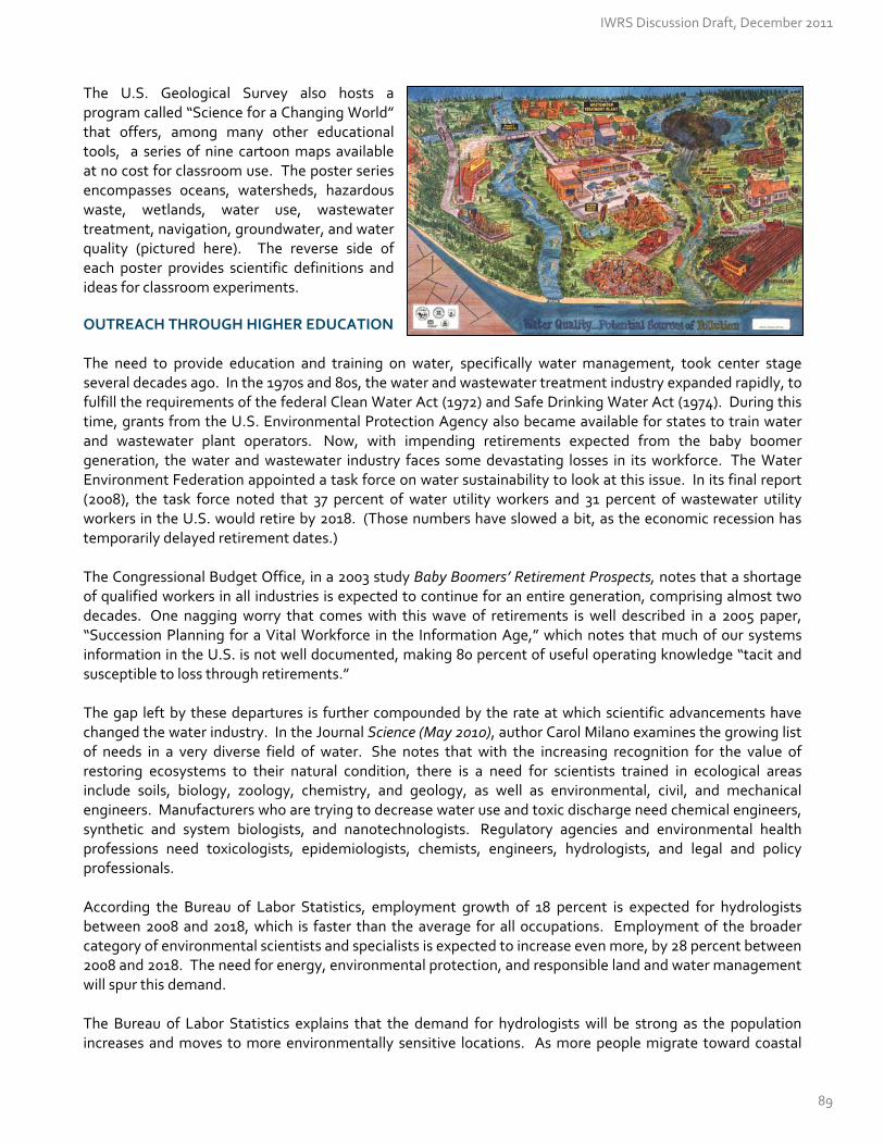
The U.S. Geological Survey also hosts a program called “Science for a Changing World” that offers, among many other educational tools, a series of nine cartoon maps available at no cost for classroom use. The poster series encompasses oceans, watersheds, hazardous waste, wetlands, water use, wastewater treatment, navigation, groundwater, and water quality (pictured here). The reverse side of each poster provides scientific definitions and ideas for classroom experiments.
OUTREACH THROUGH HIGHER EDUCATION The need to provide education and training on water, specifically water management, took center stage several decades ago. In the 1970s and 80s, the water and wastewater treatment industry expanded rapidly, to fulfill the requirements of the federal Clean Water Act (1972) and Safe Drinking Water Act (1974). During this time, grants from the U.S. Environmental Protection Agency also became available for states to train water and wastewater plant operators. Now, with impending retirements expected from the baby boomer generation, the water and wastewater industry faces some devastating losses in its workforce. The Water Environment Federation appointed a task force on water sustainability to look at this issue. In its final report (2008), the task force noted that 37 percent of water utility workers and 31 percent of wastewater utility workers in the U.S. would retire by 2018. (Those numbers have slowed a bit, as the economic recession has temporarily delayed retirement dates.) The Congressional Budget Office, in a 2003 study Baby Boomers’ Retirement Prospects, notes that a shortage of qualified workers in all industries is expected to continue for an entire generation, comprising almost two decades. One nagging worry that comes with this wave of retirements is well described in a 2005 paper, “Succession Planning for a Vital Workforce in the Information Age,” which notes that much of our systems information in the U.S. is not well documented, making 80 percent of useful operating knowledge “tacit and susceptible to loss through retirements.” The gap left by these departures is further compounded by the rate at which scientific advancements have changed the water industry. In the Journal Science (May 2010), author Carol Milano examines the growing list of needs in a very diverse field of water. She notes that with the increasing recognition for the value of restoring ecosystems to their natural condition, there is a need for scientists trained in ecological areas include soils, biology, zoology, chemistry, and geology, as well as environmental, civil, and mechanical engineers. Manufacturers who are trying to decrease water use and toxic discharge need chemical engineers, synthetic and system biologists, and nanotechnologists. Regulatory agencies and environmental health professions need toxicologists, epidemiologists, chemists, engineers, hydrologists, and legal and policy professionals. According the Bureau of Labor Statistics, employment growth of 18 percent is expected for hydrologists between 2008 and 2018, which is faster than the average for all occupations. Employment of the broader category of environmental scientists and specialists is expected to increase even more, by 28 percent between 2008 and 2018. The need for energy, environmental protection, and responsible land and water management will spur this demand. The Bureau of Labor Statistics explains that the demand for hydrologists will be strong as the population increases and moves to more environmentally sensitive locations. As more people migrate toward coastal
IWRS Discussion Draft, December 2011
89

regions, for example, hydrologists will be needed to assess building sites for potential geologic hazards and to mitigate the effects of natural hazards such as floods, landslides, and hurricanes. Hydrologists also will be needed to study hazardous‐waste sites and determine the effect of pollutants on soil and groundwater so that engineers can design remediation systems. Increased government regulations, such as those regarding the management of stormwater, and issues related to deteriorating coastal environments, and rising sea levels will stimulate employment growth for these workers. The Oregon Community College Association reports that out of the seventeen publicly chartered community colleges in Oregon, only two community colleges offer water / wastewater operator training programs: Linn‐Benton Community College (Albany) and Clackamas Community College (Oregon City). These programs are critical resources for plant operators, as they prepare for the certification and licensing exams underpinning the water and wastewater utility industry. These courses are designed to give water technicians and operators the tools to protect public health and environmental health. There is only one community college, Lane Community College in Eugene, with a water conservation technician program —specializing in the nexus between energy and water efficiency. There are no community college programs in Oregon with a robust curriculum in hydrographics—measuring water level and streamflows, and then processing the records for use after data collection. The American Water Works Association, the Water Environment Federation, and the U.S. Environmental Protection Agency have partnered to create a website to promote career choices in the water sector. Geared toward jobseekers at all levels—high school, vo‐tech, college, military second career, and advanced science—the www.workforwater.org website hosts a clearinghouse of jobs in the field of water. It also contains recruiting resources for businesses and agencies to use. The Oregon Department of Community Colleges and Workforce Development also provides a listing of colleges, water‐related courses, and degrees offered throughout Oregon. OUTREACH THROUGH THE COMMUNITY Recently, two surveys out of Oregon State University were developed to assess citizen attitudes and opinions toward water issues in Oregon. About 800 Oregonians responded to the surveys, answering questions about their level of knowledge, resources they use for information, and series of water‐related risks. According to the surveys, most Oregonians would prefer to, and are using, television news programs or specials to learn about the state’s water situation. Oregonians use local newspapers, radio programs, and online resources to gather information as well. However, only five percent of Oregonians consider themselves “very well informed” about water issues in Oregon. When it comes to using water, Oregonians believe that municipal use (drinking water, residential use, lawn irrigation, etc.) comprises 37 percent of the state’s water, when in fact, municipal water use only accounts for about 6 percent of diverted water in the state. While agricultural water use accounts for more than 80 percent of diverted water, survey respondents estimated it closer to 30 percent. When asked to rate the seriousness of water‐related risks in Oregon, agricultural practices and forestry practices affecting water quality, and drought conditions affecting water quantity ranked the highest, with nearly half of survey respondents placing these in the “serious risk” category. More than seventy percent felt that the risks from forestry and agricultural practices could be well managed, however. Through the OSU surveys, Oregonians also ranked drinking water as the most important use of water in Oregon. With drinking water ranked as the highest priority, it is not surprising that a separate survey by DHM Research in November 2011 found that water quality protection to be the number one environmental concern
IWRS Discussion Draft, December 2011
90

of residents in the Pacific Northwest. Interestingly, the OSU survey found that only 1 in 5 Oregonians were familiar with the term “non‐point source pollution,” which U.S. states report as the leading remaining cause of water quality problems, according the U.S. Environmental Protection Agency.
RECOMMENDED ACTIONS #8.A – 8.D
Action 8.A Support Oregon’s K‐12 Environmental Literacy Program
Support funding for the Oregon Environmental Literacy Plan, adopted in 2010. Under this plan, students graduating from high school should be environmentally literate. [Oregon Department of Education – public and private partners]
Action 8.B Provide Education and Training for Oregon’s Next Generation of Water Experts
Conduct a survey of water organizations in Oregon , to determine what skill sets and educational requirements are currently in use in the workplace, and which will be in demand in the future. Survey public agencies, utilities, private companies, and non‐governmental organizations to gauge the number and type of water‐related jobs in these organizations. Document the types of skill sets and education these jobs require. Note demographics of jobs currently filled (i.e., percent of incumbents currently eligible or within five years of eligibility for retirement). Describe future workforce needs in scientific, technical, policy, finance, and information technology. [Oregon University System – public and private partners].
Determine whether educational programs in Oregon are equipped to meet the coming demand for water professionals . Conduct a survey of vocational, scientific, engineering, legal, and public policy programs in Oregon colleges and universities, gauging their capacity to prepare Oregon’s next generation of water experts. Evaluate the accessibility and effectiveness of certification and licensing programs, for treatment plant operators, water conservation and efficiency experts, landscape designers, etc. [Oregon University System – Oregon Community College Association – public and private partners].
Offer internships, fellowships, and job shadow programs to expose students to careers in water. [Public and private partners]
Continue funding support for water‐related trade programs at Oregon community colleges. These programs provide the core training needed for water and wastewater plant operators before getting certified by the Oregon Health Authority. These community college programs also impart surveying skills, electronics, hydraulics, water quality testing, data acquisition, and other fundamental skills that utility plant operators need to know in today’s environment. These programs often include closely related courses such as irrigation installation techniques, industrial pre‐treatment, and stormwater management. [Oregon Department of Education – Oregon Health Authority – Oregon Community College Association]
Action 8.C Promote Community Education and Training Opportunities
Continue to promote local education and outreach through the required actions described in local Water Management and Conservation Plans.
IWRS Discussion Draft, December 2011
91

Provide technical training to soil and water conservation district staff, watershed councils, public agency employees, irrigation district manager, businesses and the public. Examples could include:
~ Farmer‐to‐Farmer Tours to demonstrate water conservation and efficiency techniques ~ “How to Use the State’s Allocation of Conserved Water Program” for water right holders. ~ “How to Test Water Quality” demonstrations for owners of domestic wells and septic systems. ~ “How to Construct Rainwater Catchment” tutorials for homeowners and businesses. ~ “How to Manage Graywater” tutorials for homeowners and businesses. ~ “How to Manage a Pharmaceutical Take‐Back Program”, and other hazardous waste collection events. ~ “How to Advance Water Conservation and Protect Water Instream,” for local nonprofit organizations,
watershed councils, and soil & water conservation districts.
[State & Federal agencies, watershed councils, soil & water conservation districts, public & private partners]
Promote access to water‐related recreational opportunities and promote responsible use and protection of water resources, through the use of the Water Trails Program at Oregon Parks and Recreation Department. [OPRD]
Action 8.D Identify On‐going Water‐Related Research Needs
Continue to identify on‐going research needs at the local and state level that could use assistance from undergraduate and graduate students, as well as public and private research partners. Organize research ideas and requests into a clearinghouse. Throughout this document, research needs have been marked with the “book” symbol (). [Oregon University System – Oregon Community College Association].
IWRS Discussion Draft, December 2011
92

CRITICAL ISSUE K: FUNDING FOR OREGON’S WATER
Critical Issue K
Funding for Oregon’s Water
This chapter lays out funding needs in three primary categories: long‐term planning, operations, and community projects. It is instructive to learn about how other states have approached these categories in recent years. Many other western states have invested heavily in water‐related planning, operations and projects, even in dire economic times. FUNDING AN INTEGRATED WATER RESOURCES STRATEGY The Oregon Legislature providing funding for two staff to develop the state’s Integrated Water Resources Strategy in 2009‐11 and again in 2011‐13. These staff members were responsible for convening and managing the public process, overseeing the scientific and technical work products, and developing and producing the content of the strategy. The state is required to update the Strategy every five years and to implement the Strategy in order to achieve our goals: to improve our understanding of Oregon water resources, and to meet our needs. This effort represents a need to invest in ongoing implementation and future updates of the Strategy at the state level. In the coming years, an effective state‐wide Strategy will require efforts at the local level as well, to develop sub‐basin (regional) plans that meet the stated goals. Investment in Planning Efforts: What Other States are Doing Other states with long‐term water planning have invested considerably in staff and consultants to conduct this work. For example, Georgia had a one‐time budget in 2009‐11 of $36 million to conduct planning across 10 regions. Texas had a $3 million budget in 2009‐11 for planning across 16 regions, and Wyoming has about $500,000 per year to conduct planning across seven basins. Oregon’s neighbors to the north and south have also made significant investments. The State of California began developing long‐term water plans 50 years ago, and is statutorily mandated to update them every five years. Although the state has set aside a budget for these purposes, it has dwindled over time from $4.5 million in 2000 to $2.5 million in 2008, and even less today. About 40 part‐time staff members work throughout the state on data collection and water budgets, 15 more are located in district offices conducting data processing, and an additional 30 to 40 experts provide in‐kind technical work. The State of Washington has 17 staff in the Department of Ecology, dedicated to long‐term planning for the Columbia River. Two staff members, paid out of project funds, manage the stakeholder and advisory process, and the 15 remaining staff write permits and administer grants for local community water development projects. OPERATIONAL FUNDS Natural resources are critical to Oregon’s economy. Natural resource activities such as agriculture, forestry, fisheries and mining, as well as recreational activities and tourism including fishing, hunting, wildlife viewing, camping and hiking are major economic drivers in Oregon’s economy.
IWRS Discussion Draft, December 2011
93
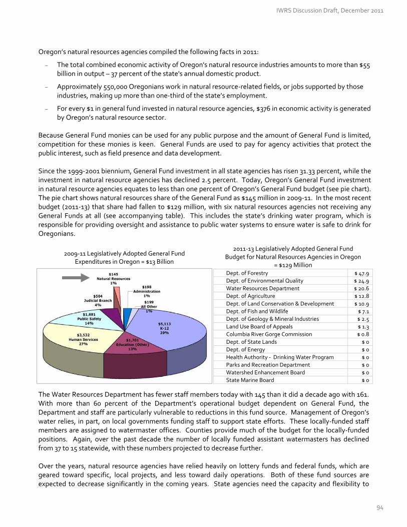
Oregon’s natural resources agencies compiled the following facts in 2011:
The total combined economic activity of Oregon's natural resource industries amounts to more than $55 billion in output – 37 percent of the state's annual domestic product.
Approximately 550,000 Oregonians work in natural resource‐related fields, or jobs supported by those industries, making up more than one‐third of the state’s employment.
For every $1 in general fund invested in natural resource agencies, $376 in economic activity is generated by Oregon’s natural resource sector.
Because General Fund monies can be used for any public purpose and the amount of General Fund is limited, competition for these monies is keen. General Funds are used to pay for agency activities that protect the public interest, such as field presence and data development. Since the 1999‐2001 biennium, General Fund investment in all state agencies has risen 31.33 percent, while the investment in natural resource agencies has declined 2.5 percent. Today, Oregon’s General Fund investment in natural resource agencies equates to less than one percent of Oregon’s General Fund budget (see pie chart). The pie chart shows natural resources share of the General Fund as $145 million in 2009‐11. In the most recent budget (2011‐13) that share had fallen to $129 million, with six natural resources agencies not receiving any General Funds at all (see accompanying table). This includes the state’s drinking water program, which is responsible for providing oversight and assistance to public water systems to ensure water is safe to drink for Oregonians.
2011‐13 Legislatively Adopted General Fund Budget for Natural Resources Agencies in Oregon
= $129 Million Dept. of Forestry $ 47.9
Dept. of Environmental Quality $ 24.9
Water Resources Department $ 20.6
Dept. of Agriculture $ 12.8
Dept. of Land Conservation & Development $ 10.9
Dept. of Fish and Wildlife $ 7.1
Dept. of Geology & Mineral Industries $ 2.5
Land Use Board of Appeals $ 1.3
Columbia River Gorge Commission $ 0.8
Dept. of State Lands $ 0
Dept. of Energy $ 0
Health Authority ‐ Drinking Water Program $ 0
Parks and Recreation Department $ 0
Watershed Enhancement Board $ 0
State Marine Board $ 0
2009‐11 Legislatively Adopted General Fund Expenditures in Oregon = $13 Billion The Water Resources Department has fewer staff members today with 145 than it did a decade ago with 161. With more than 60 percent of the Department’s operational budget dependent on General Fund, the Department and staff are particularly vulnerable to reductions in this fund source. Management of Oregon’s water relies, in part, on local governments funding staff to support state efforts. These locally‐funded staff members are assigned to watermaster offices. Counties provide much of the budget for the locally‐funded positions. Again, over the past decade the number of locally funded assistant watermasters has declined from 37 to 15 statewide, with these numbers projected to decrease further. Over the years, natural resource agencies have relied heavily on lottery funds and federal funds, which are geared toward specific, local projects, and less toward daily operations. Both of these fund sources are expected to decrease significantly in the coming years. State agencies need the capacity and flexibility to
IWRS Discussion Draft, December 2011
94
take advantage of cost‐share opportunities with the federal government. Oftentimes, dollars removed from state budgets result in dollars lost at the federal level. Agencies have also relied on “fees for service;” however, these funds do not completely cover the real cost of conducting transactions and have suffered with the recent economic recession as well. The declining trend of disinvestment of General Fund must be reversed, in order to ensure Oregon’s natural resource legacy for future generations and to implement our shared vision into the future. Natural Resource agencies in Oregon are developing a number of ideas to stabilize their budgets from the free‐fall in General Fund, and are watching other western states with interest, as they do the same. One important concern with any new funding source will be to ensure equitability among all types of water users. Alternatives to the General Fund: What Other States Are Doing The State of California has been working for several years to establish a funding mechanism that relies less on the General Fund in order to pay for its day‐to‐day operations. In 2003, the California Legislature passed Senate Bill No. 1049, directing the California Water Resources Control Board’s Water Rights Division to charge annual user fees to fund its operations. The Water Rights Division regulates water rights through a permit and licensing program. As a result, water permit and license holders were charged a fee of $100 or $0.03 per acre‐foot of water, whichever was higher. This fee was designed to cover a budget of approximately $7 million. Although challenged in the courts by water users, the water right fee program was found to be “facially constitutional” by unanimous decision of the California Supreme Court in 2011 and is operating today. In Minnesota, there are approximately $75 million of dedicated water funds available each year under Minnesota's 2008 Land, Water and Legacy constitutional amendment. The amendment increased the general sales and use tax rate by three‐eighths of one percentage point (0.375 percent) to 6.875 percent and dedicated one‐third of the resulting additional proceeds to water quality protection, one‐third to the restoration of wetlands and other wildlife habitat, and the remaining third to support parks, arts, and cultural heritage efforts. FUNDING LOCAL WATER RESOURCE PROJECTS Oregon’s state agencies and several of its federal counterparts have a variety of funding mechanisms available to pay for water resource projects, ranging from infrastructure development and maintenance, to water supply, conservation, and re‐use projects, and watershed protection and restoration activities.
Infrastructure Finance As previously mentioned under Critical Issue I (Water‐Related Infrastructure), Oregon communities have a number of opportunities to access infrastructure finance, from revolving loan funds, to state and federal grants, and the bond market as well. See the Rural Community and Assistance Corporation’s Oregon webpage for the “Oregon Water and Wastewater Funding and Resource Guide” containing additional state and federal funding sources (Visit www.rcac.org, and click on Oregon in the drop‐down box). Water Supply, Conservation, and Re‐Use Funds Local communities often find it difficult to secure feasibility study funding as part of their project development. Such a study helps determine the environmental, engineering, economic, and social feasibility of proposed water resource projects. In 2008, the Water Resources Department awarded approximately $1.3 million in feasibility study grants to 21 Oregon communities, plus funds for the Umatilla Basin Aquifer Recovery Project. In 2011, the Oregon Legislature provided another $2.1 million for this grant program. In 2009 the Oregon Legislature, through House Bill 3369, established grants and loans for the “implementation phase” of water development projects. The Legislature directed the initial appropriation to the Umatilla Basin Aquifer Recovery Project.
IWRS Discussion Draft, December 2011
95

Watershed Restoration Funding Since 1999, the Oregon Watershed Enhancement Board has awarded 5,500 grants totaling $434 million to partners in Oregon. OWEB grants are funded from the Oregon Lottery, federal dollars, and salmon license plate revenue. This has resulting in more than 5,100 miles of stream restoration, including improved stream habitat and removal of fish passage barriers. In addition, more than 5,400 miles of stream banks have received riparian forest restoration, benefiting salmon and steelhead. Oregon consistently reports about the same length of stream mile restoration as Alaska, California, Idaho, Washington, and Pacific Northwest Tribes, combined. As an added benefit, the Ecosystem Workforce Program out of the University of Oregon recently completed a research project and found that every $1 million of public investment in clean water and habitat restoration creates about 15‐24 total jobs. Organizations that receive OWEB grants typically hire local businesses. Most of these businesses are small, with less than $1 million in revenue. The research shows that 90 percent of OWEB investments stay within Oregon, as restoration project managers hire consultants, contractors, and employees to design, implement and maintain projects. Consultants and contractors in turn hire field crews, rent or purchase equipment, and buy goods and services. Employees spend wages on goods and services to support their livelihoods in their local communities. The payoffs of habitat restoration projects yield immediate jobs at a level very similar to traditional infrastructure investments. Funding Local Water Projects: What Other States Are Doing The State of Washington secured $200 million in general obligation bonds to fund water supply projects in 2006. The Washington Legislature directed the Washington Department of Ecology to allocate two‐thirds of the money to out‐of‐stream uses and one‐third to augment instream flows. The 2006 Act (Chap. 90‐90 RCW) also directs the Washington Department of Ecology to publish a water supply inventory annually and long‐term water supply and demand forecast every five years. Each year, the Washington has used these monies to fund projects consistent with its legislative mandate to "aggressively pursue development of water supplies to benefit both instream and out‐of‐stream water uses." The accompanying map shows the projects under active development in the Columbia River Basin, using these monies.
IWRS Discussion Draft, December 2011
96

By the end of 2011, the Washington Department of Ecology had half of these funds committed (about $100 million) to pursue feasibility studies for the almost 40 programs shown here. Storage projects shown here are multi‐purpose and for the most part focus on expansion/modification of existing storage sites. The exception is in the Yakima Basin, where the focus is on developing new storage facilities with the Yakima Tribe. The Yakima Project alone will likely cost $3 million over the next 25 years. One significant challenge that local communities face when funding water‐related projects is how to navigate a confusing maze of state, federal, and private funds for all phases of the project, while continuing to meet the goals of the local community. The Whole Watershed Restoration Initiative, described below, was created to help project proponents make sense of the funding maze.
Integrated Funding: The Whole Watershed Restoration Initiative
‐ Cathy P. Kellon, Ecotrust
The Whole Watershed Restoration Initiative (WWRI) is a competitive salmon habitat restoration grant program in Oregon, Washington and Idaho. The WWRI is a public‐private partnership whereby state and federal agencies contribute restoration dollars to the Initiative and Ecotrust, a nonprofit, then makes these pooled funds available as grants to local groups for on‐the‐ground restoration work. Our goal is to restore natural ecosystem processes for the benefit of salmon and communities. Our approach is to fund work where there is strong community support, effective collaboration, and high ecological value to salmon. Highlights Each year the WWRI awards between $1 and $2 million in grant funds for restoration activities. 95 projects have been funded under the WWRI since 2008. These projects are anticipated to result in 206
miles of decommissioned roads, 492 stream miles opened to anadromous fish, 307 miles of stream habitat improved for anadromous fish, and 4,745 acres of improved habitat.
Projects funded in 2011 alone will engage 300 volunteers and generate at least 20,000 hours of paid work. Public and Private Organizations Working Together Started in 2007, the WWRI is a partnership comprised of Ecotrust, the Oregon Watershed Enhancement Board (OWEB), Pacific Northwest Region 6 of the USDA Forest Service (USFS), the National Oceanic Atmospheric Administration’s Restoration Center (NOAA), the Bureau of Land Management (BLM), and the Natural Resource Conservation Service (NRCS/USDA). As the coordinator and hub of the Partnership, Ecotrust signs bilateral agreements with each of the Partners and then, in turn, provides oversight and administration of all sub‐grantee contracts, including fiscal management, compliance with federal and state guidelines and reporting requirements, and coordination of WWRI program activities. We work closely with all Partners to ensure the sub‐grantee contracts meet the relevant funding agency’s criteria while minimizing the administrative burden on sub‐awardees. Focus Watersheds The WWRI makes strategic investments by taking a Protect the Best approach: investing in river basins with the highest conservation values for salmon, in projects most essential to the recovery of natural watershed processes, and where there is demonstrated local support. 1. Restore high priority watersheds first ‐‐ Instead of spreading limited funds thinly across the landscape, we
invest in selected areas only. Currently, we work in nine priority basins and 28 focus watersheds therein. These areas were identified using our conservation planning tools and have been updated over the years to align with the priorities of new Partners.
IWRS Discussion Draft, December 2011
97
2. Measure success at the watershed scale, not the stream reach ‐‐ We invest in projects that will eliminate chronic risk factors, not band‐aid solutions, so as to recover major ecological functions throughout a watershed, across all ownerships. Examples of funded work include fish barrier removals, stream channel restoration, and road decommissioning.
3. Rely upon local expertise and priorities ‐‐ We look for projects that have been identified as top priorities in
existing plans such as watershed action plans, limiting factors analyses, or salmon recovery plans and we grant project funds to community‐based groups with proven experience in restoration work.
Benefits of Partnering The WWRI brings together “money of different colors” from its federal and state agency partners. This makes our dollars go further; helping grantors and grantees in a number of ways:
WWRI grantees work with a single entity and a single set of forms yet have access to multiple funding sources.
Even though each Partner’s funding has particular restrictions on use, a WWRI grant can typically cover most project activities by mixing and matching source funding.
WWRI grantees don’t have to meet standard match requirements. The WWRI provides some ‘built‐in’ non‐federal match from our partner, OWEB, resulting in only 50 percent non‐federal match requirements, rather than the customary one‐to‐one match. In turn, the WWRI can fund high quality projects where non‐federal match monies are scarce.
Partners each contribute technical expertise. For example, NOAA completes all NEPA compliance documentation for projects it helps to fund and Ecotrust is able to undertake socio‐economic assessments as well as communications and media outreach.
The WWRI process creates a forum for grantors to share ideas and learn more about each other; contributing to additional agencies adopting more strategic approaches to the ways they fund salmon habitat restoration.
Challenges in Partnering (Note: this section reflects the opinion of the author and not necessarily the WWRI) The primary challenge we face is not unique, nor is it probably surprising to most people: government agencies are typically not set up to partner with outside organizations, even if their mandates or objectives align with one another. While the inspiration for the WWRI was rooted in shared interests and goals, it was made possible by the effort of individuals. To make the partnership a reality, individuals figured out how to work with their organization’s rules and norms to create terms of reference and trial different ways of working as partners. While the WWRI is comprised of innovative and collaborative people, it is, in many ways, still reliant upon the attentiveness of, and trust among, individuals rather than upon institutional change or design. Of course, running a funding program with outside entities, particularly as partners (as opposed to a client‐vendor relationship), requires staff time and dedication. In the case of the WWRI, Ecotrust takes on much of that leadership and coordination work for the partnership. However, relying upon a nonprofit partner may not always be the right choice, in which case, agencies will also need to develop internal capacity to launch and maintain coordinated funding programs. While there may be challenges to partnering, the risks of failing to address today’s environmental challenges are arguably more daunting than any institutional rules or norms. Given the complexity of modern problems, it is hard to imagine resolving them from under one roof. If institutions can reward integrity, creativity, efficacy, and adaptation in the pursuit of meaningful goals, then methods like collaboration can become more than just commonplace; they can become easier and more efficient too.
IWRS Discussion Draft, December 2011
98

RECOMMENDED ACTIONS #9.A – 9.D
Action 9.A Fund Development and Implementation of Oregon’s IWRS
Fund development and implementation of the state IWRS. The goals, objectives, and recommended actions spelled out in the Integrated Water Resources Strategy will be meaningless without adequate funding. Fund the implementation of the 2012‐17 IWRS, including coordination among state, local, federal, and private partners to address IWRS Recommended Actions #1 through 12. Implementation also includes development of further project detail for legislative action; fulfillment of scientific, outreach, and policy obligations; documentation of lessons learned; and development of subsequent (required) iterations of Oregon’s Integrated Water Resources Strategy.
Fund development of regional (sub‐basin) IWRS [See Action #10A]. Re‐structure an existing grant fund to help communities conduct water resource planning described under Action #10A. A previous funding program, called the Oregon Water Supply and Conservation Initiative (OWSCI), was last capitalized in 2007. [OWRD – DEQ – state agencies]
Action 9.B Fund Water Resource Management Activities at the State Level The state’s core responsibilities related to water, described in detail throughout this document, are underfunded and have been for years. Core activities include oversight (water allocation, distribution, and protection), data collection and processing, permitting and enforcement, and technical assistance for Oregon communities.
Fund those water resource management activities for which the state has responsibility. Oregon’s natural resources agencies need an increased and adequate commitment of funding from the state’s General Fund, as well as other funding sources. Without adequate funding, the state is poorly positioned to manage its water resources in pursuit of economic development and environmental protections.
Action 9.C Fund Communities Needing Feasibility Studies for Water Conservation, Storage, and Re‐Use Projects
Provide grants that help communities evaluate the feasibility of specific water conservation, storage, and re‐use projects. A funding program, called the SB 1069 Grant Program for Water Conservation, Storage, and Re‐Use was last capitalized for the 2011‐13 biennium for $1.2 million. [OWRD – DEQ – state agencies]
Action 9.D Fund Communities Implementing Water Conservation, Storage, and Re‐Use Projects
Provide grants and loans to assist with the implementation of water conservation, storage, and re‐use projects. Previous grant and loan programs, established under HB 3369 (2009), could be re‐capitalized for this purpose. [OWRD – DEQ – state agencies]
Establish an on‐line clearinghouse of information related to available funding / incentive programs. {See Action #1.A and #7.B.} [OWRD – DEQ – OBDD – OHA – Federal Partners]
IWRS Discussion Draft, December 2011
99

CRITICAL ISSUE L: PLACE‐BASED EFFORTS
Critical Issue L
Place‐Based Efforts
Although everything we do in the natural resources community has a sense of “place,” the concepts in this bulletin focus on two specific topics: regional (sub‐basin) water resource planning, and partnership with tribes and neighboring states. REGIONAL (SUB‐BASIN) WATER RESOURCES PLANNING In November 2011, 23 of Oregon’s 36 counties participated in a water resources planning survey administered by the Oregon Water Resources Department. County commissioners filled out these surveys, providing their personal perspectives during the Association of Oregon Counties’ Annual Meeting. Commissioners noted which water issues had come before their county commissions during the past 12 months. Counties have had very different exposure to water‐related issues, with more than half of the respondents (12 counties) discussing at least seven water‐related issues during the past year. One county commission reported having discussed all 16 of the listed issues, compared with two commissions that had dealt with one only one issue each, as noted on the graph below.
Number of Water Issues before Each Commission
IWRS Discussion Draft, December 2011
100

“My County is Well Underway with County‐Wide, Integrated Water Resource Planning”
1 = Strongly Agree
1 = Strongly Agree
“My County Commission is Well Versed in Water Resources Issues”
The issues themselves were wide‐ranging, with the most frequent discussions focusing on the need for better: water data (indicated by 15 counties), water resource planning (14), water‐related funding (14), water quality (13), and wastewater infrastructure (12). The table displays the issues that have arisen before county commissions in 2010‐11.
Water Issues Discussed by County Commissions
# of County Commissions
Water data 15
Water resource planning 14
Funding 14
Water quality 13
Wastewater related infrastructure 12
Water conservation 11
Water related to energy & electric power 11
Water storage 11
Water re‐use 10
Additional Streamflow for instream needs 10
Public health related to water 9
Water‐related education and training 9
Water supplies 9
Ecosystem health related to water 8
Climate change adaptation 6
This feedback confirms the results of a 2007 water supply planning survey of county planners. In that survey, counties also ranked water data as their number one need. The majority of counties surveyed in 2007 (85 percent), requested more information about the availability of water supplies in their communities, particularly in the area of groundwater. In the 2011 survey, commissioners then indicated whether they felt that “my county commission is well versed in water resource issues,” providing a rating on a scale from 1 to 5, with 1 representing “strong agreement” with the statement. Responses diverged widely, but tended toward the negative, with nine respondents “disagreeing” or “strongly disagreeing” with the statement. Results tended even more toward the negative when asked to comment on whether “my county is well underway with county‐wide, integrated water resource planning (meeting water quantity, water quality, and ecosystem needs). Twelve counties, more than 50 percent, disagreed or strongly disagreed with the statement. In an effort to discern how well county commissions are positioned to undertake or participate in regional water resource planning, the survey asked about the nature of their relationships with local stakeholders and partners. Commissioners were asked to comment on the statement, “my county commission has regular contact with the following stakeholders, which may position us well to conduct regional water resource planning.”
IWRS Discussion Draft, December 2011
101

Stakeholder groups were then listed, again accompanied by a scale of 1 to 5, with 1 meaning “strongly agree with the statement.” In general, commissions indicated regular contact with soil and water conservation districts, watershed councils, and irrigation districts. They indicated less regular contact with wastewater and stormwater managers, businesses, and municipal water providers. They indicated having the least contact with environmental groups and tribes. In a separate question, they were asked to comment on their working relationship with neighboring county commissions, which received the most positive response of all (an average of 2.3), see below. “My Commission has strong working
relationships with…” Average Rating 1= Strongly Agree
Neighboring County Commissions 2.3
Soil & Water Conservation Districts 2.3
Watershed Councils 2.4
Irrigation Districts 2.6
Wastewater and Stormwater Managers 3.0
Businesses 3.0
Municipal water providers 3.1
Environmental Groups 3.2
Tribes 3.3
Finally, the survey asked commissioners how they believe the state can best help with local water resource planning. “Funding with grants” was the most frequent response (indicated by 16 counties), followed by providing water quality data (12), providing water availability data (11), assistance identifying other funding sources (9), and identifying best practices in water management (8).
Rank How can the State help with county‐wide
water resources planning?
1 Funding with grants 16 counties
2 Providing water quality data 12 counties
3 Providing water availability data 11 counties
4 Identifying other funding 9 counties
5 Identifying best management practices 8 counties
6 Information briefings of county commission 7 counties
7 Technical assistance 7 counties
8 Funding with loans 6 counties
9 Training of county staff 1 county
Oregon’s Basin Programs State agencies have long taken a basin approach to watershed planning, although they have often stopped short of convening local partners to plan next steps that address water quantity, water quality, and ecosystem needs. In Oregon, water supply planning has been implemented on a river basin‐by‐river basin basis. In the late 1950’s, the state began developing river basin water plans, collectively referred to in statute and rule as “basin programs.” These plans have a narrow focus that apportions or designates each basin’s water for certain “classified uses” based upon present water supply uses, constraints, and needs. Examples of classified uses include domestic, livestock, municipal, irrigation, power development, industrial, mining, recreation, wildlife,
IWRS Discussion Draft, December 2011
102

pollution abatement and fish life uses. These basin programs do not take a proactive approach to understanding and mapping out a strategy to meet long‐term water needs. The Water Resources Department, responsible for developing these basin programs, organizes its work around 18 administrative basins.
The Department of Environmental Quality also uses basins for planning purposes, albeit with different boundaries. DEQ has recently developed water quality status and action plans for the North Coast, Rogue, and Deschutes basins, and will be developing plans for the Tualatin, Mid‐Coast and Burnt‐Powder basins in 2012. Implementing these plans integrates actions across agricultural, forest, urban, and rural residential land uses. DEQ designates a broad spectrum of entities that are responsible for managing and regulating pollution across these land uses. These entities are federal, state, and local governments and agencies, including cities, counties and special districts within the basin.
The Oregon Watershed Enhancement Board works with watershed councils in the state, and organizes along six regions in order to award grants for restoration projects. The Department of Forestry has three Forest Practice Regions. The Drinking Water Program at Oregon Health Authority has two regions, and the Oregon Business Development Department works along county lines. The Oregon Department of Fish and Wildlife uses a common geographic area with similar genetic and life history characteristics, called Species Management Units, for conservation and recovery planning of native fish populations. All of these boundaries have evolved historically, based on differing mandates, funding sources, federal partners, and local resources and needs. Although these agencies write distinct and separate workplans, they do comment on each other’s workproducts, providing recommendations based on their own missions, mandates, and understanding of the resource. There may be even more opportunity in the future to integrate these workplans, through shared data, staff, or other resources. Local Communities’ Experience with Regional Planning Some communities in Oregon are moving in the direction of integrated, regional planning, bringing more diverse stakeholders to the table to address water quantity, water quality, and ecosystem issues. The Deschutes Water Alliance was formed in 2004 to find ways to balance the water needs of agriculture, cities, and rivers in the Deschutes Basin. The Deschutes Water Alliance consists of voting and non‐voting representatives from several irrigation districts and cities, the Confederated Tribes of Warm Springs, and the Deschutes River Conservancy, an organization focused on restoring streamflows and water quality in the basin. One of the major challenges of taking on a regional, more integrated approach to water planning is that in any given basin, there are many interested parties to convene. There could be irrigation districts, municipal water providers, conservation districts, watershed councils, drainage districts, wastewater and stormwater utilities, local governments (counties/cities), and environmental groups. Add to this list the state, federal, and tribal natural resource agencies with water, land, or fish management responsibilities, and other public, private, and non‐profit organizations with an interest in water resource issues. Within a basin (or sub‐basin), there will likely be multiple plans that involve water resources in some way – for example, one might find:
Water management and conservation plans (by an municipal water provider, or irrigation district) Fish recovery plans (ODFW) A basin plan for water allocation (OWRD) A TMDL for improving water quality (DEQ), along with local implementation plans (counties, cities)
IWRS Discussion Draft, December 2011
103

Local land‐use plans by cities or counties Restoration action plans by watershed councils within the basin Locally developed agricultural water quality management plans
Each plan will likely have its own goals and objectives, with varying expectations and outcomes, making it difficult for a group of basin stakeholders to conduct their own planning and implement projects strategically to meet water quantity, water quality, and ecosystem needs. Further complicating the matter, a wide variety of methodologies, formats, and geographic coverage makes it difficult to compile data on such a wide array of issue areas and with diverse organizations.
Regional Water Planning Benefits by Household (annual)
$0
$10
$20
$30
$40
Atlanta Boston Seattle Phoenix Houston
Does Regional Water Planning Really Work?
‐ Mark Anderson and Michelle Girts, CH2M Hill
Does Regional Water Planning Really Work? Yes. Experience has shown that, indeed, regional water planning can produce measurable, positive results that improve supply, better manage natural resources, and increase cooperation that benefits communities. In Oregon, the Talking Water Gardens project, for example, is a unique public‐private partnership that enabled two cities and a high‐tech company to address their water needs as a cooperative. The cities of Albany and Millersburg and ATI Wah‐Chang pooled financial resources to plan and build a new kind of water reclamation system: an engineered wetland that mimics the cleansing and cooling characteristics that occur in nature. This project, designed by CH2M HILL, garnered federal financial support and was constructed for a fraction of the cost of conventional facilities, while improving Willamette River water quality for fish habitat and downstream uses, and providing recreational space to the community. The effort has been recognized with awards from the Oregon Department of Environmental Quality, U.S. Environmental Protection Agency, and other organizations. The Talking Water project is not unique in creating measurable benefits. Nationally, research has shown that—in five U.S. metro areas—the median net benefit of a regional water planning effort is about $10 per household each year. Success is measured differently from one community to another and often includes some (or all) of these attributes:
A balanced water supply that meets current and future demands
Water quantity and quality that supports a healthy watershed
Economic use of resources
Source: Schneemann, M. (November 25, 2008) Economic Value of Regional Water Supply Planning. Research presented to the Northeastern Illinois Regional Water
Supply Planning Group, Chicago, Illinois.
Financial strength to build, manage, and maintain the systems needed to make it all work
Regional Water Planning Produces Benefits Sometimes success is simply getting everyone around the table to agree on the next step. Just as it has taken many decades to build our communities, farms, and industries, it will take years—if not generations—to reap the full benefits of regional planning. A good plan must be flexible to adapt to a changing world, keeping options open for pathways and partners to address tomorrow’s uncertainties.
IWRS Discussion Draft, December 2011
104
In our experience, here are three keys to success: 1. Water is one piece of a larger puzzle. First, start with an understanding that all water is part of a system
that includes land, energy and other resources. Talking Water Gardens is an example of this. It treats all water resources as part of human and natural systems. Cities and industries partner to solve shared problems. Wetlands simultaneously treat the water, serve as habitat for birds and animals, and create a public amenity.
2. Plan to be flexible. Secondly, acknowledge that the future is uncertain and carries risks that must be
managed. By using a “scenario planning” approach, we can consider how changes in population, employment, crop demands, climate, and natural resources might affect the plan. Rather than planning for one future scenario, we investigate many possibilities and decide, together, how to prepare for the biggest risks.
3. Apply state‐of‐the‐art technology. Finally, embrace scientific advances in water management that improve
results and reduce costs. This may include water treatment methods—like the wetlands used in Talking Water Gardens ―and management techniques such as aquifer storage and recovery (ASR). Make full use of growing expertise in disciplines such as conflict resolution, shared vision planning, and decision science.
The computer age makes it possible to quickly evaluate complex systems to identify the best outcomes. Communities are now able to apply innovative tools to look at many possible solutions and future scenarios in an organized way—with decision makers in the room—to test and plan for the best and worst cases. These Oregon projects show three examples of communities that are making ground‐breaking regional planning efforts work. City of Damascus The City of Damascus, a 12,000‐acre area in the Clackamas and Willamette Basins, is expected to grow to 50,000 residents by 2060. This semi‐rural community at the eastern edge of the Portland metropolitan area was recently incorporated. To serve expected growth, the City developed an integrated water resource management (IWRM) plan for water, wastewater, and stormwater infrastructure. In cooperation with several regional service providers, the plan—the first of its kind in Oregon—capitalizes on a unique opportunity to consider urban water management from a local watershed perspective, while taking into account water supply, environmental health and ecosystem services, drainage and flood control, and water re‐use, treatment, and disposal as part of a single system. Joint Water Commission, Washington County The primary drinking water supplier in Washington County, the Joint Water Commission (JWC), comprises five member agencies: the cities of Hillsboro, Forest Grove, Beaverton, and Tigard, and the Tualatin Valley Water District (TVWD). Each member agency has individually owned water‐related facilities and varying levels of ownership in the JWC and the JWC’s water treatment, storage, and transmission facilities. The JWC prepared what may be the state’s most comprehensive water management and conservation plan (WMCP) because it addresses the unique supply and conservation collective needs of all the associated water utilities. Through collaboration and an intergovernmental agreement, JWC members agreed to share resources to meet future needs, and established consensus on water demand projections, conservation targets, and long‐range water supply plans. Klamath Water and Power Agency The Klamath Water and Power Agency (KWAPA) is a recently formed interstate joint powers/inter‐governmental agency made up of irrigation and improvement districts many of which are signatories to the Klamath Basin Restoration Agreement (KBRA). The purpose of KWAPA includes assisting irrigators with the
IWRS Discussion Draft, December 2011
105
Critical Issue L: Place-Based Efforts

development and implementation of a water management plan covering a significant area and numerous districts within the Klamath Project. The plan provides an opportunity for irrigators and the broader community to work together to identify locally‐based solutions to energy, water, and other management issues to the benefit of all within the basin. KWAPA is currently developing an “On Project Plan” (OPP) in coordination with numerous stakeholders. This plan will align water supply and demand within the Klamath project and may include conservation, additional storage, use of ground water for supplemental irrigation, or other options/agreements. Several western states, including California, Colorado, New Mexico, Oklahoma, and Texas, have taken a more formal approach to regional planning, with direction and funding coming from the state. In each of these cases, regional or basin councils are formally delineated, with staff and budget assigned, stakeholders seated at the table and, workplan and reporting requirements in place. Results of these regional plans then roll up into state‐level plans. These plans traditionally have focused on water quantity and water supply issues, but increasingly they are broadening efforts to encompass water quality, ecosystem needs, and climate change challenges as well. PARTNERSHIP WITH TRIBES AND NEIGHBORING STATES Partnership with tribes and neighboring states has played an important role in Oregon history. Today, we have an opportunity to strengthen these partnerships through the Columbia River Treaty, Klamath Basin Restoration Agreement, technical coordination, and local projects. Partnership with Federally Recognized Tribes All of Oregon’s natural resource agencies and economic development agencies have built relationships with the state’s federally recognized tribes on a government‐to‐government basis. With regard to water, these relationships often revolve around environmental justice issues, water needs and water rights, water quality monitoring, or watershed management and restoration. Tribal members sit on state boards, policy advisory groups, and technical advisory groups in order to provide perspective and guidance. These discussions range from awarding project grants, to facility siting, to long‐term water policy. The Oregon Department of Fish and Wildlife works with the Columbia River Treaty Tribes (Nez Perce, Umatilla, Warm Springs and Yakama), the Shoshone‐Bannock Tribe, state fish and wildlife agencies in Washington and Idaho, the U.S. Fish and Wildlife Service (USFWS) and National Oceanic and Atmospheric Administration (NOAA) Fisheries on a variety of fisheries management and fish production issues in the Columbia River basin under the “2008 ‐ 2017 U.S. v. Oregon Management Agreement.” This plan was developed and implemented under the ongoing supervision of the U.S. District Court in Portland, Oregon. Species managed under the Agreement include white sturgeon, Chinook, coho and sockeye salmon, walleye, lamprey, shad and steelhead. The Confederated Tribes of the Umatilla Indian Reservation (CTUIR) offer an essay below that describes how the CTUIR Department of Natural Resources has recently organized its institutional structure and day‐to‐day operations in order to better reflect not only the Tribe’s culture and history but also the physical realities of the ecosystem that provides the Tribe’s food.
IWRS Discussion Draft, December 2011
106
Critical Issue L: Place-Based Efforts
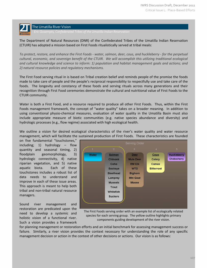
The First Foods serving order with an example list of ecologically related species for each serving group. The yellow outline highlights primary
components guiding development of the river vision.
The Umatilla River Vision
‐ Eric Quaempts, Confederated Tribes of the Umatilla Indian Reservation
The Department of Natural Resources (DNR) of the Confederated Tribes of the Umatilla Indian Reservation (CTUIR) has adopted a mission based on First Foods ritualistically served at tribal meals: To protect, restore, and enhance the First Foods ‐ water, salmon, deer, cous, and huckleberry ‐ for the perpetual cultural, economic, and sovereign benefit of the CTUIR. We will accomplish this utilizing traditional ecological and cultural knowledge and science to inform: 1) population and habitat management goals and actions; and 2) natural resource policies and regulatory mechanisms. The First Food serving ritual in is based on Tribal creation belief and reminds people of the promise the foods made to take care of people and the people’s reciprocal responsibility to respectfully use and take care of the foods. The longevity and constancy of these foods and serving rituals across many generations and their recognition through First Food ceremonies demonstrate the cultural and nutritional value of First Foods to the CTUIR community. Water is both a First Food, and a resource required to produce all other First Foods. Thus, within the First Foods management framework, the concept of “water quality” takes on a broader meaning. In addition to using conventional physio‐chemical measures, evaluation of water quality in the Umatilla Basin must also include appropriate measure of biotic communities (e.g. native species abundance and diversity) and hydrologic processes (e.g., flow regime) associated with high ecological health. We outline a vision for desired ecological characteristics of the river’s water quality and water resource management, which will facilitate the sustained production of First Foods. These characteristics are founded on five fundamental “touchstones,” including; 1) hydrology – flow quantity and seasonal timing, 2) floodplain geomorphology, 3) hydrologic connectivity, 4) native riparian vegetation, and 5) native aquatic biota. Each of these touchstones includes a robust list of data needs to understand and improve in each of these issue areas. This approach is meant to help both tribal and non‐tribal natural resource managers. Sound river management and restoration are predicated upon the need to develop a systemic and holistic vision of a functional river. Such a vision provides a framework for planning management or restoration efforts and an initial benchmark for assessing management success or failure. Similarly, a river vision provides the context necessary for understanding the role of any specific management decision or action in the context of other decisions or actions. Our vision is as follows:
IWRS Discussion Draft, December 2011
107
Critical Issue L: Place-Based Efforts

“A healthy river is capable of providing First Foods that sustain the continuity of the Tribe’s culture. This vision requires a river that is dynamic, and shaped not only by physical and biological processes, but the interactions and interconnections between those processes.” A functional river requires preserving or restoring the seasonal timing and volumes of river flows necessary to support the production and harvest of First Foods. Baseflow conditions (low flows during the late summer and early autumn) in the Umatilla River determine the availability of aquatic habitats within the river as well as summertime hydrologic connectivity within the river network. Thus, summertime migrations of salmon, lamprey, and other species are influenced by the magnitude of baseflow. Baseflow in any given year also influences water quality (since concentrations or pollutants are influenced by flow volume) and even the temperature regime of the river. In addition to baseflows, management planning for desired flow regimes requires consideration of the magnitude and frequency of peak flow events. Peak flow events maintain the dynamic nature of the floodplain morphology and channel pattern, which facilitates the flux of river water through floodplain gravels and maintains a variety of aquatic habitats in the channel and across the floodplain. For examples, floods that are sufficient to mobilize the streambed are critical to the ecological function of the rivers. Such high‐flow events provide temporary surface water connections between main channel and off‐channel aquatic habitats, build and rearrange important channel and gravel‐bar features across the floodplain thereby maintaining habitat diversity, enhance water movement through the floodplain aquifer by cleaning and sorting river sediments thereby facilitating hyporheic water flux, and recharge the alluvial aquifer with water. A functional river, then, is dependent on the sufficient magnitude and frequency of flood events to maintain dynamic channel patterns and adequate water exchange rates between the channel and floodplain sediments. Finally, the transitional periods between peak and baseflows are also ecologically important. The “falling lim” (reduction in river flow after a period of high water) of the annual hydrograph during the early summer can be ecologically important for spawning of fishes, establishment of cottonwoods, and maintenance of vernal pools on the floodplain for floodplain amphibians. Additionally, when rivers drop too rapidly from a peak flow to base flows, fish can be trapped in transient off‐channel habitats on the floodplain that may dry up as the flood recedes. The hydrograph of a functional river, then, would include transitions between high flow events and low flow events that are compatible with maintenance of the native aquatic community of the river. In addition to the volume of water in the channel, a functional river is defined by the physical, chemical, and biological aspects of water quality. The river should be free from pollutants (e.g., toxicants or excess nutrients) that impair drinking water supplies, alter stream water pH, and stress or kill native aquatic fauna. Maintenance of appropriate water temperature regimes, including cool temperatures during the summer, is especially important because water temperature influences dissolved oxygen concentrations, stress levels of aquatic organisms, growth of pathogens, and the competitive abilities of non‐native fishes versus native fishes. In short, a functional river would have nutrient and contaminants levels that do not impede First Foods production and the utilization and safe consumption of First Foods by the tribal community. The First Foods‐focused mission highlights direct linkages between the ecological health of the rivers and the health and well‐being of Umatilla tribal members. Degradation of the river, water quality, and associated ecological processes results in the loss of traditional tribal foods. This loss of food resources is linked to increasing occurrences of health issues (e.g., poor fitness, diabetes). In additional to providing a clean and healthy natural environment for tribal members and other residents of the Umatilla Basin, improving the availability of First Foods can contribute to sustaining tribal ceremonies, knowledge, and traditions that promote the physical health of tribal members. Finally, the First‐focused mission provides resource managers in the basin with a framework for involving tribal members in management dialogues. Within such a
IWRS Discussion Draft, December 2011
108
Critical Issue L: Place-Based Efforts
framework, monitoring and restoration efforts can concentrate on improving the ecological functionality of the river, which ultimately sustains First Foods. This text is an excerpt from Krista L. Jones, Geoffrey C. Poole, Eric J. Quaempts, Scott O’Daniel, and Tim Beechie, “The Umatilla River Vision,” May 2011. Partnership with Neighboring States Oregon shares surface water resources—the Snake River, the Columbia River, and the Klamath River—with its neighboring states. It also shares significant groundwater aquifers with its neighbors, and coordinates data collection and sharing so that water managers on both sides of our borders can manage the resource effectively. Economic Needs in the Columbia River Basin: There are water supply issues throughout areas of Oregon, none more severe than in parts of Umatilla and Morrow Counties. The Water Resources Department (WRD) has documented significant groundwater declines throughout these counties (up to 500 feet in some wells), and has established four critical ground water areas in this region. Within these critical ground water areas, two‐thirds of permitted ground water use has been curtailed. These restrictions have limited economic growth, and for years Umatilla and Morrow Counties have expressed interest in developing Columbia River water as an offset. Fish Needs in the Columbia River Basin: There are 13 federally‐listed species of salmon and steelhead that migrate through the Columbia River, and they migrate downstream to the Pacific Ocean at the same time that irrigation demand is greatest (summer months). Historically, salmon and steelhead evolved to migrate downstream primarily on spring runoff, taking advantage of flow conditions and a river that had slope. As the Columbia was dammed and converted to a series of reservoirs, the river’s natural flows were slowed, delaying and altering the timing of migrating fish. Travel time for smolts is estimated to have doubled or tripled over travel time before the dams were built. This delay makes migrating fish more vulnerable to predation and the affects of temperature and disease as they spend more time in the slow moving water behind reservoirs. To compensate for reduced spring run‐off and a river that is much flatter, target flows for the Columbia River are designed to move out migrating salmon and steelhead smolts from their original streams, through Columbia River reservoirs, into the estuary and out to the ocean with timing that is more similar to historic conditions. To overcome the reduced spring run‐off and flatter slope of the river, it takes a lot more flow to move fish downstream than it did historically. Current Law. For a number of years, neither Oregon nor the state of Washington has issued new water rights without mitigation from the mainstem Columbia during the growing season (i.e., “live flow appropriations”), primarily to meet target flows that have been established to protect threatened and endangered fish. In Oregon, applications that propose to divert water from the Columbia River are processed under Oregon Revised Statute 537.150 through 537.175. In 1992, the Water Resources Commission adopted additional public interest standards for reviewing new water right applications in the upper Columbia Basin. These rules, known as the “Division 33 rules,” were developed to protect federally‐listed salmon and steelhead in the mainstem Columbia and Snake Rivers, as well as tributaries of the Columbia above Bonneville dam. With only a few exceptions, the rules preclude new uses of water from the upper Columbia River from April 15 to September 30 each year because of flow targets in effect for listed fish. The Division 33 rules provide applicants the opportunity to propose mitigation, in order to secure new water rights during the April 15 to September 30 time frame. However, the Department must determine if the
IWRS Discussion Draft, December 2011
109
Critical Issue L: Place-Based Efforts
proposed mitigation is consistent with the Oregon Department of Fish and Wildlife (ODFW) Mitigation Goals and Standards. For new water withdrawals from the mainstem Columbia River, ODFW recommends replacement of the instream water flow of equal quantity and quality. Opportunities. Although fish still need flows in the fall and winter months there is significantly more water available for allocation during this time. Current rules and statutes allow for new diversions from the Columbia River during the period October 1 through April 14. The WRD and ODFW completed an analysis as to whether water is available to divert from the Columbia River during winter without negatively impacting fish. Both agencies have agreed there is winter water available to divert and store. The major constraint in the winter is target flows for chum salmon below Bonneville dam from November through April. These flows are needed to maintain water over established chum salmon redds until fry emergence. Target flows are met more than half the time except in November and December when the Columbia is at its low flow point. The State’s strategy for meeting Columbia Basin water needs is to find ways to store high flow winter water from the Columbia so that it is available when it is needed. In 2007, 2008, 2009 and 2011, the Oregon Legislature invested monies into efforts in the Umatilla Basin to capture and store winter water from the Columbia River. There are a number of other efforts underway to develop or update long‐term programs related to transboundary waters. United States, Canada, and Tribes. The Columbia River Treaty between the United States and Canada was established in 1964, bringing significant flood control and power generation benefits to both countries. The year 2024 marks the end of 60 years of pre‐paid flood control space from Canada. In addition, either Canada or the United States can terminate most of the provisions of the Treaty any time on or after Sep. 16, 2024, with a minimum 10 years’ written advance notice, making 2014 another important benchmark year for this Treaty. The U.S. Army Corps of Engineers and the Bonneville Power Administration, the agencies responsible for implementing the Treaty on behalf of the United States, are conducting a multi‐year effort to study these post‐2024 Treaty issues. This effort is called the 2014/2024 Columbia River Treaty Review. Stakeholders have embarked on a rather vocal campaign to elevate the subjects of water supply and ecosystem services into the top tier of discussion items. California, Oregon, and Tribes. Representatives of more than 50 organizations, including Federal agencies, Oregon and California, Indian tribes, counties, irrigators and conservation and fishing groups signed the Klamath Basin Restoration Agreement and Klamath Hydroelectric Settlement Agreeement on February 18, 2010. These agreements set signatories on a path to comprehensive solutions for the Klamath Basin. The Restoration Agreement is intended to: 1) restore and sustain natural fish production and provide for full participation in ocean and river harvest opportunities of fish species throughout the Klamath Basin; 2) establish reliable water and power supplies which sustain agricultural uses, communities, and National Wildlife Refuges; and 3) contribute to the public welfare and the sustainability of all Klamath Basin communities. The Hydroelectric Settlement lays out the process for additional studies, environmental review, and a set of decisions by the Secretary of the Interior regarding the removal of four PacifiCorp dams.
IWRS Discussion Draft, December 2011
110
Critical Issue L: Place-Based Efforts

RECOMMENDED ACTIONS #10.A – 10.B
Action 10.A Undertake Regional (Sub‐Basin) Integrated, Water Resource Planning
Develop regional (sub‐basin) integrated, water resource plans, describing how local communities would propose to quantify and meet their water needs, using a template provided by the state. Water needs include water quantity, water quality, and ecosystem challenges, both instream and out‐of‐stream. These plans should evaluate potential groundwater and surface water resources, and should include an evaluation of the tools and technologies featured in Recommended Action #11 and #12, such as water conservation and water‐re‐use, built and natural storage, public health and ecosystem health protections, and water sharing arrangements. These efforts should involve all interested stakeholders and the public. {Local communities – State – Federal – Tribal partners}
Provide technical assistance to communities undertaking regional (sub‐basin) integrated, water resource planning. Technical assistance may include collecting and providing data, providing engineering or other guidance during alternatives analysis, and developing a template for regional plans. The state has an important role in providing information to local decision‐makers, and helping to identify and evaluate water resource management options, without abrogating any of its regulatory or decision‐making authorities.
Next steps include defining geographic scale, participation, administration, and funding for regional plans. {See Actions #1.A and #1.B for data and technical assistance and Actions #9.A., #9.C, and #9.D for funding assistance.} {Local communities – State – Federal – Tribal partners}
Compile relevant and readily‐available water‐related information to support regional (sub‐basin) integrated water resources planning. Agencies should work together to compile information related to water quantity, water quality, and ecosystem challenges and opportunities. Stakeholders can use these reports to identify opportunities for collaboration, set priorities, and develop action plans. These efforts could build upon DEQ’s water quality focused, basin‐based “Status and Action Plans” to generate a more comprehensive inventory of information in each basin. {See Action #1.A.}
Action 10.B Partner with Tribes and Neighboring States in Long‐Term Water Resource Management
Protect Oregon’s interests in the Columbia, Snake, and Klamath Basins, ensuring the state’s ability to meet instream and out‐of‐stream needs into the future. Issues to be addressed include, but are not limited to, potential participation in projects of (Washington’s) Columbia River Basin Water Management Program; allocation of winter water as appropriate from the Columbia River for irrigated agriculture and economic development; fishery health, and continued participation in the Columbia River Treaty and Klamath Basin Restoration Agreement. [State — Northwest Power Planning Council — Tribes — Federal — Local partners]
IWRS Discussion Draft, December 2011
111
Critical Issue L: Place-Based Efforts

CRITICAL ISSUE M: WATER RESOURCE DEVELOPMENT
Critical Issue M
Water Resource Development
As we plan for Oregon’s water future, we will need to develop new and innovative management tools for meeting the many needs of Oregonians and the natural environment. Three such tools are called out here for further development: water‐use efficiency and conservation, built storage, and water re‐use. (The following chapter features additional tools focused on public health and environmental health.) WATER‐USE EFFICIENCY AND WATER CONSERVATION One of the more recognized water management techniques is water conservation. Water conservation is defined in state law as a means of eliminating waste or otherwise improving the efficiency of water use by modifying the technology or method of diverting, transporting, applying or recovering water. Water conservation is a tool that can be implemented in any water use sector. For example, Oregon residents and businesses alike can conserve water by replacing certain appliances, such as toilets, dishwashers, and washing machines with more water efficient models. Or, add faucet aerators to bathroom and kitchen sinks, and install low flow showerheads to use less water without reducing water pressure. Landscaping techniques, such as maintaining healthy soils, planting drought tolerant or native plants, and watering when temperatures are cooler, are all actions that contribute to water conservation. As another example, agricultural operations can convert to a more efficient irrigation system, including weather‐based irrigation systems, moisture sensor controls, drip irrigation, lining canals or piping, or variable speed pumping. Several irrigation districts in central Oregon are improving their water delivery systems through lining and piping projects to better manage water supplies. Allocation of Conserved Water The state’s Allocation of Conserved Water Program allows a water right holder who conserves water to use a portion of the conserved water on additional lands, while a portion of the conserved water is permanently protected instream. Examples of eligible conservation practices include lining canals, and changing the water distribution system from flood irrigation to sprinkler or drip irrigation. To date, more than 44 applications have been approved, resulting in almost 95 cfs of water permanently protected instream. Challenges. Public outreach efforts as part of this program have revealed several barriers to conservation.
Energy Costs. Sometimes, water efficiency‐improvement projects can result in an increase in energy consumption and burdensome costs to the user.
Forfeiture. A (mis)perception that conserving water will result in forfeiture of water rights.
Funding. A central place to find all funding opportunities by various entities does not exist, making it difficult to coordinate grant awards for projects and meet certain application and reporting deadlines.
IWRS Discussion Draft, December 2011
112

Information Gaps. Many water right holders are unaware of the existence of the Allocation of Conserved Water program and how it can help them meet their needs.
Protecting Water Instream. Protecting the water that has been conserved through efficiency improvement projects is a challenge because of a lack of measurement, monitoring, and field staff to enforce its protection instream.
Reduced Return Flow. Water conservation may result in reduced return flows to the stream and reduced recharge to groundwater, creating unintended consequences to other water users downstream.
Despite these challenges, Oregon has a number of tools to offer and success stories to share. Funding and Technical Assistance To encourage efficient water use, many federal, state and local entities offer technical and financial assistance, incentives, and informational resources. Many water providers offer rebates for the purchase and installation of water efficient appliances; some also provide shower timers, leak detection kits, and water conservation consultations free of charge to their customers. State agencies with water‐related conservation programs include the Water Resources Department, Oregon Department of Agriculture, DCBS / Building Codes’ Reach Program, Oregon State University Extension Service, and Oregon Department of Energy. Federal agencies with water‐related conservation programs include Natural Resources Conservation Service (USDA), Bureau of Reclamation, Bonneville Power Administration, and the Environmental Protection Agency. Soil and water conservation districts, and watershed councils also promote a variety of water conservation programs. The Oregon Department of Energy, Energy Trust of Oregon, and the Oregon Watershed Enhancement Board are a few of the entities that provide funding through tax credits, cash incentives, and grant programs. Water Management and Conservation Plans The water management and conservation planning process provides water users an opportunity to estimate long‐range water supply needs, and identify potential sources of supply, including water conservation programs, to meet those needs. The Water Resources Department provides a template for municipalities to follow as they develop these plans, and requires municipal water suppliers to prepare plans as conditions of their water use permits or permit extensions. A municipal Water Management and Conservation Plan, or “WMCP,” provides a description of the water system, identifies the sources of water used by the community, and explains how the water supplier will manage and conserve supplies to meet future needs. The Department coordinates a similar, voluntary program for agricultural water management and conservation planning, and provides a template for these plans as well. Under the conservation planning program, agricultural water suppliers examine their supply, demand, future needs, and water conservation tools. By using this process, irrigation districts and other suppliers can create a “water budget” for their current and future needs. Application of appropriate conservation tools may also lead to an increase in available water supplies to better meet their patrons’ crop demands. Irrigation districts with plans approved by the Water Resources Department are able to take advantage of statutory provisions that allow the transfer of water rights from one district user to another to prevent forfeiture of the rights due to non‐use. Piping and Lining as a Water Conservation Technique Open canals, traditionally used to convey water throughout much of much of the state, face a distinct disadvantage in Central Oregon, where porous volcanic rock has caused significant leakage and loss from open and unlined irrigation canals. Between 1992 and 2002, the U.S. Bureau of Reclamation engaged in a
IWRS Discussion Draft, December 2011
113

formal study to evaluate which piping and lining techniques and technologies fared the best in Central Oregon’s harsh weather conditions and rocky terrain. An analysis of several options concluded that a “geomembrane with concrete cover” offered the best long‐term performance. In truth, all of the techniques and technologies field tested among Central Oregon’s irrigation districts have yielded positive results. Bureau of Reclamation researchers concluded that “for all lining alternatives, benefit/cost analysis shows that every $1 spent on maintenance returns $10 in conserved water by increasing effectiveness and design life.” The Bureau calculated these savings by assuming $50 per acre‐foot for the value of the conserved water. They arrived at this figure by observing that:
“…farmers typically pay an assessment of $8 to $20 per acre‐foot for the water delivered by their irrigation district. Additional water (when available) can usually be purchased for about twice this cost ($15 to $40 per acre‐foot). These costs only reflect the costs for building and maintaining the infrastructure and for delivering the water…When cities and developers need to purchase water on the open market, they typically pay $100 to $300 per acre foot, with higher prices paid in drought years and in areas where water is especially scarce. Based on this range of prices, a value of $50 per acre‐foot seemed quite reasonable.”
The Bureau cautioned that water that leaks from unlined canals may be providing value for environmental, domestic, and irrigation uses, requiring thorough assessments before undertaking any changes. For example, “Seepage from canals may contribute to groundwater and wetlands. [These impacts] should be assessed prior to canal lining. This assessment may be mandated for projects using federal funding…More often, canal seepage returns to the river or contributes to local groundwater.”
Piping and Lining Projects in Central Oregon
‐ Kevin Crew, Black Rock Consulting
Over the past 15 years, there has been a great emphasis on water conservation and river flow enhancement projects, especially in the arid Central Oregon region. To meet these goals, irrigation districts have been actively developing piping and lining projects, which transmit water from the source to the customer, without losses into the porous rock that lines much of Central Oregon’s open canals. Irrigation Districts have identified these projects as part of their Water Management and Conservation Plans, required of most irrigation districts by the Oregon Water Resources Department. Black Rock Consulting has been directly involved in the planning, design and construction of more than 60 miles of piping and lining projects in the Central Oregon region. Below are six examples. Tumalo Irrigation District. In the 1990s and 2000s, Tumalo Irrigation District near Bend, Oregon, implemented a conservation project to completely pipe the open reaches of its Bend Feed Canal with 84 inch diameter high density polyethylene pipe. This four‐mile long project conserved approximately 20 cfs of water, with more than 17 cfs of the conserved water protected instream in Tumalo Creek. This additional water served to re‐wet the seasonally dry reach of Tumalo Creek, restoring connectivity with the Deschutes River and delivering much needed flows and cool water to that river. The use of Oregon’s “Allocation of Conserved Water Program,” the solution of complicated hydraulic modeling issues, and the use of 84‐inch diameter pipe material, as well as increasing public safety and trail systems, earned this project a Consulting Engineers Association of Oregon Honor Award and ACEC National Recognition Award. The District has built upon these successes by launching a similar project on the Tumalo Feed Canal.
IWRS Discussion Draft, December 2011
114

Central Oregon Irrigation District. Central Oregon Irrigation District has implemented a variety of water conservation and piping projects, including the 2.5 mile, 9 foot‐diameter Juniper Ridge Hydroelectric Power Project penstock pipeline. This pipeline project serves multiple benefits, including the conservation of 20 cfs, the placement of water back into the Deschutes River during irrigation season, and pressurization necessary to operate the 3.8 MW hydroelectric power plant. Central Oregon Irrigation District has more than 400 miles of canal systems, so the benefits of future piping in that District could be substantial. Neighboring North Unit Irrigation District has piped and lined more than 22 miles of canals and has another five miles of pipeline planned for the future. These projects return conserved water to the Crooked River and help prevent fine sediments from discharging to sensitive habitats. In 2009, the Swalley Irrigation District completed more than five miles of pipeline that conserved more than 30 cfs, returning flows to the Deschutes River and creating pressurization necessary its hydro‐electric power generation plant. Laying pipe for COID’s Juniper Ridge Project Rock Creek Irrigation District in Wasco County commissioned the design of more than 14 miles of irrigation system piping, and is now seeking funding in conjunction with the Wasco Soil and Water Conservation District for the project. Finally, Three Sisters Irrigation District has worked with the Natural Resources Conservation Service to pipe a large portion of its district, conserving water and enhancing anadromous fish flows in Wychus Creek, a tributary of the Deschutes River and part of the Pelton Round Butte reintroduction project. The District has also received substantial financial assistance from the Bureau of Reclamation, providing cost match with District time and equipment. Challenges
Lining pipe for COID’s Juniper Ridge ProjectPiping and lining projects are successful as water conservation tools when funding is available to mitigate the construction costs. Such projects produce multiple public benefits including returning flows to rivers and streams, reducing maintenance costs, and developing pressurization that can support the
IWRS Discussion Draft, December 2011
115
development of hydroelectric power. They also prevent the migration of soils to downstream reaches that may contain critical habitat or host sensitive species. However, in urbanizing environments, pressures have been placed on Districts by adjacent property owners to maintain open canals for visual aesthetics. One potential solution is to line canals to prevent seepage, while keeping them open to provide continued aesthetics; however, lining generally increases water conveyance velocity and the associated risks to the public. Districts have generally chosen to enclose canals, providing a benefit to the general public through water conservation. The largest ongoing obstacle is the lack of funding due to current economic conditions. Although Districts and other interests are actively pursuing existing funding opportunities, these have become increasingly competitive and funding sources have dramatically decreased in quantity and funding capacity. At the same time, Districts have faced increasing regulation costs that have increased assessments to patrons, while the capacity of patrons to pay has also declined. This has resulted in a diminished capacity for Districts and other entities to self fund or participate in projects to the same degree that they have in the past.
BUILT STORAGE The history of storing water in Oregon dates back to the 1800s when projects consisted mostly of ponds or small dams across streambeds. As the state’s population grew, so did the scale and purpose of these projects. Before long, developers and governments were building major dams and reservoirs to meet the increasing water demands for power production, flood protection, and out‐of‐stream needs during the dry summer months. In Oregon today, there are more than 15,000 water rights authorizing the storage of surface water. Most water rights are for small ponds or reservoirs storing less than 9.2 acre‐feet, although, Oregon does have more than 60 reservoirs with capacities of over 5,000 acre‐feet each. The largest reservoir in the state is the U.S. Bureau of Reclamation's Owyhee Lake in southeastern Oregon with over 1 million acre‐feet (0.3 cubic miles) of storage. Most of the reservoirs in Oregon were built, at least partially, to store irrigation water. The value of “multipurpose” storage projects is codified in the state’s water storage policy, adopted in 1992 by the Water Resources Commission. This policy identifies storage as an integral part of Oregon’s strategy to enhance public and private benefits from use of the state’s water resources. The policy also acknowledges that both structural and non‐structural methods should be used in Oregon to store water. In 1993, the Oregon Legislature adopted a policy on storage facilities, declaring it a high priority to develop environmentally acceptable and financially feasible multipurpose storage projects and to enhance watershed storage capacity through natural processes using nonstructural means. Below Ground Storage ‐ Aquifer Storage and Recovery (ASR) and Artificial Recharge (AR) The use of Aquifer Storage and Recovery and Artificial Recharge is gaining interest in Oregon because of its smaller environmental footprint and potential benefits to water quality. In 2008, the Water Resources Department evaluated 54 groundwater aquifers within Oregon, creating a rating system of “geologic suitability for underground storage.” This used an original methodology that helps assess the suitability of potential sites for underground storage. The Department evaluated aquifers in terms of their physical ability to store water. The analysis did not include an economic or environmental feasibility analysis, only a hydrogeologic evaluation of how these areas accept and retain water. The most suitable locations are located in the northern portion of Oregon, where geology, water availability, and cost‐benefit circumstances create a favorable environment for this water management tool.
IWRS Discussion Draft, December 2011
116

Methods of underground storage include infiltration into shallow aquifers and injection into deep aquifers, as shown in the figure. Two administrative processes are available to develop these projects: Aquifer Storage and Recovery (ASR) and Artificial Recharge (AR). Aquifer Storage and Recovery is defined as “the storage of water from a separate source that meets drinking water standards in a suitable aquifer for later recovery and not having as one of its primary purposes the restoration of the aquifer.” Artificial Recharge is defined as “the intentional addition of water diverted from another source to a groundwater reservoir.” The table below points out some of the primary differences between the two processes.
Category Artificial Recharge Aquifer Storage & Recovery
Water Use Primarily irrigation, industrial Primarily drinking water
Recharge Method Seepage systems, Injection wells Injection wells only
Water Quality Requirements Recharge water cannot impair or degrade groundwater quality
Recharge water must meet drinking‐water standards
Water‐Rights Permits required to appropriate source water and to pump recharged groundwater
Can use existing rights to store and recover the water
Governing Statutes /Rules ORS 537.135 OAR 690‐350‐0120
ORS 537.531 to 537.534 OAR 690‐350‐0010 to 690‐350‐0030
Authorizations for both of these processes are issued by the Oregon Water Resources Department in collaboration with the Department of Environmental Quality, which ensures that projects meet Underground Injection Control Standards (UIC), as well as underground water quality protection requirements. Another important partner is the Oregon Health Authority, which oversees compliance with drinking water quality requirements, since: 1) groundwater must be protected to the highest beneficial use, 2) treated drinking water is the only source water allowed for direct injection, and 3) injected water must be compatible with the natural groundwater. Finally, the Oregon Department of Fish and Wildlife (ODFW) is a partner, wherever surface water is used as sourcewater; ODFW consults with the Water Resources Department on permit conditions.
Groundwater Storage Techniques in Oregon: Aquifer Storage & Recovery/Artificial Recharge
‐ Jeff Barry, GSI Water Solutions
Both ASR and AR facilitate the use of available water in a sustainable manner to replenish a natural resource and use for water supply. Both tools are referred to as “aquifer storage” in this essay. Oregon is an ideal location to use aquifer storage because of the state’s unique geologic and hydrogeologic environment. Underlying much of the land surface in northern Oregon is a series of very thick, ancient lava flows, called the Columbia River Basalt Group. These layers of lava flow contain an extensive system of aquifers that can be used to store and retrieve water for use when needed. In addition, parts of Oregon are underlain by other types of volcanic rocks, and gravel and sand that also may be suitable for aquifer storage applications.
IWRS Discussion Draft, December 2011
117

Benefits of Aquifer Storage Water can be stored underground when available (such as during the winter) and extracted for use during peak season demands (such as late summer) or to meet demands for drinking water and irrigation water. This type of scenario is depicted below.
In addition to the ability to store water when it is available for use when it is needed, aquifer storage has other benefits, especially when compared to the way we have traditionally stored water using storage tanks and reservoirs. These benefits include:
Water storage cost and smaller environmental footprint. A much larger volume of water can be stored underground at a substantially lower cost compared to using tanks or reservoirs. In addition, aquifer storage eliminates or significantly reduces potential environmental and other impacts associated with the development of large above‐ground storage facilities.
Less water loss. A significant amount of water is lost through evaporation when stored in above‐ground facilities such as reservoirs. This type of water loss is eliminated with aquifer storage.
Cooler water. Aquifer storage yields cooler water than above‐ground reservoirs and storage tanks. Cooler water is advantageous for summer use by consumers, and it is a benefit when stored water is used to supplement low flows in a stream because fish and other aquatic life typically need cooler water temperatures.
More secure water supply. Aquifer storage presents fewer opportunities for tampering with a water supply, or for accidental contamination of the water supply compared to water storage in above‐ground reservoirs or tanks. Underground storage can serve as a supplemental, or back‐up, water source.
More benefits to the environment. Aquifer storage can reduce the need for using surface water sources during the summer, when irrigation, municipal, and domestic demands are higher. Summer streamflow is critical to preserving fish habitat and supporting the aquatic environment.
Maintains groundwater resources. Aquifer storage does not deplete native aquifers. Aquifer storage often is used to restore aquifers that have been depleted by over‐use. Aquifer storage is an excellent water management tool used to manage the sustainable use of our natural aquifers.
Improved groundwater quality. Aquifer storage can benefit groundwater quality by displacing poor quality groundwater that currently resides in the aquifer with higher quality (cleaner) water. It also can be used to prevent the influx of seawater into aquifers in coastal areas and it has been used to impede the flow of contaminated water.
IWRS Discussion Draft, December 2011
118

Challenges to Aquifer Storage Development Aquifer storage can help Oregon protect, maintain, and potentially improve its water resources. Rules designed to permit ASR and AR in Oregon have been very helpful; however, based on experience gained from developing multiple projects in Oregon during the past 15 years, challenges remain in implementing their use in Oregon. Some of these challenges are:
Water quality standards. Oregon’s water regulations govern how aquifer storage can be implemented. These regulations have been designed to be flexible in allowing water that already has been treated for use as drinking water to be injected into the subsurface for storage. Although injecting water into aquifer storage for later use as a drinking water hardly seems controversial to most of us, treated water may contain some chemicals used to disinfect the water to ensure its safety. In some states, the presence of those low quantities of disinfectants, such as chlorine, could prevent its use in a similar manner (it could violate the “anti‐degradation” requirement prescribed for waters of the state), even though the chemicals don’t represent a health risk and in most cases quickly dissipate. Oregon’s water regulations, while protective, recognize that the overall benefits of aquifer storage far outweigh these concerns.
Water quality testing cost. ASR and AR rules require a significant amount of testing and reporting to regulatory agencies throughout the project, which increases operation and maintenance costs. Consideration should be given to requiring significantly less water quality testing after it has been shown that the source water quality is acceptable.
Potential water loss during storage. The amount of stored water that is lost and the amount that can be recovered is often difficult to determine without long‐term (multiple years) monitoring results. It is important that project owners be able to access as much of the stored water as possible to keep these projects affordable.
Basalt aquifers. ASR in basalt aquifers in Oregon has been highly successful. This success depends on the ASR wells being able to tap multiple water‐bearing zones. Because of the layered nature of these geologic formations, it is important to guard against commingling of water from different aquifers in the basalt. Well construction rules regarding commingling apply to all wells, including ASR wells. Data collected during development of ASR Projects could help determine whether such conditions are occurring.
Potential impact on other water users. Recovery of water stored in an aquifer potentially could reduce or affect the availability of water to other nearby users. The potential impact to other users is evaluated during the feasibility and pilot phases of a project.
Protection of stored water. After water is stored in the aquifer, there is no regulatory mechanism, other than the regulation of water rights```11``, for preventing other users from recovering stored water. Consideration should be given to establishing a special groundwater storage management zone to make sure stored water is protected for project developers.
.
Peak and ecological flow protection. Diversion of water for aquifer storage during the winter months raises concerns about whether peak and ecological flow functions in the stream or river are adequately protected. To date, the Water Resources Department and Department of Fish and Wildlife have evaluated the effects of storage projects on peak and ecological flows on a case‐by‐case basis. In order to provide grants and loans for above‐ and below‐ground storage projects, the state is required to protect peak and ecological flows.
We believe that these challenges can be worked out collaboratively with the regulatory agencies, thus maintaining Oregon’s leadership position in the use of underground water storage techniques.
IWRS Discussion Draft, December 2011
119
Aquifer Storage Projects in Oregon The state has issued “limited licenses” to 18 entities for testing the use of ASR. In addition, the state has issued one ASR permit and five AR permits. The potential for aquifer storage ranges from municipalities that need to supplement their water supplies for their communities, to farmers and ranchers, who can use the tool to supplement irrigation water. GSI Solutions has worked with several Oregon communities to develop groundwater storage systems. Below are four examples. ASR Program, City of Baker City. Baker City relies primarily on surface water from high mountain spring
sources. During the spring, the surface water source periodically contains turbidity and so the City must rely on a backup water supply well. The basalt aquifer tapped by this well cannot support long‐term pumping and pumping rates drop off significantly in the late summer. ASR has been implemented by the City as a means of augmenting natural recharge to the aquifer so the well can sustain pumping through the peak summer months or in case it is needed in an emergency. The City completed a feasibility study that showed ASR could meet the City’s objectives. The City moved forward with the permitting, design, and testing of an ASR system using the City’s well. Pilot testing has shown that ASR significantly improves the production and quality from the City’s well with no adverse impacts. Baker City received the first permanent ASR permit issued in Oregon.
Umatilla Basin Critical Groundwater Area Recharge Project, Oregon. This project, funded in part by the
Water Resources Department, focused on determining whether aquifer recharge and ASR can promote sustainable agricultural pumping in the region and provide benefits to fish in the Umatilla River. A feasibility study funded by SB1069 (2008) grant funds indicated that the project was feasible. The first stage of implementing the project has been undertaken using HB3369 (2009) grant funds administered by OWRD. The first phase consists of permitting, design, and construction of a new pipeline and infiltration basin and it includes utilizing an existing pump station on the Columbia River that will deliver up to 10,000 acre‐feet of water to the recharge area.
Agricultural ASR, Madison Farms and McCarty Ranches, Echo. The basalt aquifer in the Butter Creek
Critical Groundwater Area (BCCGA) located near Hermiston has experienced more than 500 feet of water level decline due to over‐pumping. As a result, many deep wells have been shut off. Without artificial recharge, these farmers will not be able to irrigate their land using these wells. ASR has been implemented at Madison Farms and McCarty Ranches so that these deep wells can again be used to irrigate land that has been fallowed. The source of the recharge water is shallow alluvial groundwater that is available only in the wintertime. A permit to conduct ASR testing was obtained and a pilot project was started in 2006. Up to 900 acre‐feet of water annually has been stored and recovered from these two wells. Results indicate that ASR is feasible in the basalt aquifer and that recovered water has become an important part of the overall supply of water to the farms. These were the first agricultural ASR projects in the country.
ASR Program, City of Beaverton. Since 1997, Beaverton has been implementing ASR to meet peak seasonal
demands. The City has 6.0 million gallons per day of ASR capacity and has now drilled its fourth ASR well. During the past 14 years of operation, the ASR system has become an important element of the City’s overall supply (up to 25 percent of the peak supply) and has saved the City significant money by deferring a new water transmission line and eliminating the need to purchase water from the City of Portland to meet peak demands.
Aquifer storage has also been used successfully on an individual project basis to provide a reliable, cost‐effective, and sustainable source of high quality water to entities across the state. Based on creative work elsewhere in the United States and abroad, in the future, aquifer storage could be far more widely used to manage aquifers in an integrated manner. Examples include:
IWRS Discussion Draft, December 2011
120

Small‐scale ASR projects. Hillsboro School District needed to find an alternative water supply when faced with significant system development charges to connect to a local water district. In this case, the District is implementing small‐scale ASR to provide 10 million gallons of stored water for irrigation during the summer. ASR also could be integrated with above‐ground storage tanks to provide additional cost‐effective storage.
ASR for heat exchange. The Boise White Paper plant in Wallula, Washington is developing an ASR system to store cold Columbia River water diverted during winter months for use during the summer to reduce cooling costs for plant operations and provide an environmental benefit by leaving water in the river during the dry season.
ASR for power generation. As a result of an often large drop in static water level of injection wells, co‐generation of power is achievable at ASR projects; however, a more streamlined permitting process is needed because power projects are regulated by the Federal Energy Regulatory Commission.
Use of Class A re‐use water for ASR/AR. In arid parts of the world, ASR/AR projects often use Class A re‐use water to recharge the aquifer and the recovered water is used for irrigation, including irrigation of food crops. In addition, the point of compliance for meeting water quality standards for these projects is where the water is recovered versus the point of entry, which allows the natural ability of the aquifer to scrub and clean the re‐use water.
AR for streamflow enhancement. The Walla Walla Basin Watershed Council has been operating under a limited license for aquifer recharge since 2004. The purpose of the license is to test streamflow enhancement.
Oregon’s annual water cycle and unique underlying geology, its regulations that are protective but flexible, and its collective desire to support environmentally sustainable solutions to our water resource challenges have supported a robust development of aquifer storage in the state. Future development of aquifer storage projects is constantly being evaluated and, because of a cooperative regulatory environment, Oregon is rapidly becoming a leader in aquifer storage. For us to continue the development of affordable aquifer storage projects in the face of technical uncertainties, communities and state agencies will need to continue to partner on data collection, new techniques, and adaptive management approaches to underground storage. Above‐Ground Storage (Reservoirs) Today, there is a mix of both publicly and privately owned above‐ground storage reservoirs throughout Oregon. The largest of these are federal storage projects. There are four federal reservoir systems that are not fully allocated, representing key points of discussion between the state and two federal agencies, the U.S. Army Corps of Engineers and the U.S. Bureau of Reclamation. However, in the Crooked River Basin and the Willamette Basin, it is difficult to secure long‐term contracts for unallocated water. Inventory of Potential Storage Sites. The Water Resources Department maintains an inventory of potential water storage sites in Oregon. The purpose of developing the inventory was to create a clearinghouse for storage information. No attempt was made to assess the ecological or economic feasibility of these sites. The Department has provided this information so that communities can avoid “reinventing the wheel,” in terms of site investigation. To date, the Department has mapped the location of more than 1,200 potential above‐ground storage sites. This information came from staff, other state, local, and federal agencies, and the general public. The Department has marked each site and linked all available information to the project, including capacity curves, reservoir inundation areas, and site maps.
IWRS Discussion Draft, December 2011
121

Inventory of Large Reservoirs in Oregon. Approximately 1,300 dams are within Oregon’s dam safety jurisdiction. Of those, more than 100 structures are owned, operated, or supervised by federal organizations. Some examples of these federal organizations are the Corps of Engineers, Bureau of Reclamation, and certain hydroelectric power generating facilities licensed by the Federal Energy Regulatory Commission (FERC). The Oregon Water Resources Department inventory of large Oregon dams is used to conduct regular inspections. Information available includes dam height, storage, dam name, location, permit number, and hazard classification. This information is publicly available through an online search tool. The map below shows locations of large dams that fall within the State’s program (greater than or equal to 10 feet in height and impound 9.2 acre feet or more in storage).
The Willamette Basin Reservoir System. The Willamette Basin Reservoir System. The U.S. Corps of Engineers operates 13 dams and stores 1.6 million acre‐feet of water in the reservoirs located on the Willamette River and its tributaries. Congress authorized the construction of these reservoirs for a variety of purposes, including flood control, navigation, generation of hydroelectric power, irrigation, potable water supply, and pollution reduction. The U.S. Bureau of Reclamation currently holds water right certificates for 1.6 million acre‐feet of storage for irrigation use, and is authorized to negotiate contracts with irrigators for that water. Other water interests in the basin, including municipal water providers and instream interests, would also like to have access to this stored water. An effort between the State, Corps, the Bureau and basin stakeholders began in the early 90’s to allocate the water to multiple uses, however, it was put on hold in 2000 until issuance of the Biological Opinion (BiOp). In 2008, the National Oceanic and Atmospheric Administration issued the BiOp. It identifies quantities of water needed instream to support listed species. Scientific and
IWRS Discussion Draft, December 2011
122
technical studies are being conducted on the Willamette River tributaries, helping to pin down the actual amount needed for instream flow. State, local, and federal efforts are currently underway to re‐allocate the 1.6 million acre feet of storage among more types of beneficial uses, and to put a contract program place to give these other uses access as well. Prineville Reservoir, Crooked River Basin. Similar conversations are occurring in the Crooked River Basin to allocate 82,518 acre‐feet of uncontracted water in Prineville Reservoir to meet increasing demands for fish and wildlife, municipal use, agriculture and recreation. Prineville Reservoir, southeast of Prineville on the Crooked River, was built by the Bureau of Reclamation in 1960, and is currently authorized for irrigation and flood control only. WATER RE‐USE The State of Oregon encourages the re‐use of water, so long as the use protects public health and the environment. Interest in water re‐use projects continues to grow in Oregon. Several agencies, including the Oregon Health Authority, Department of Environmental Quality, Oregon Water Resources Department, and the Oregon Department of Consumer and Business Services (Building Codes Division), are very involved in water re‐use programs. The Oregon Association of Clean Water Agencies has identified recycled water use as a top priority for its members. The State of Oregon already encourages water re‐use of three general categories of water: Graywater refers to water from showers, baths, bathroom sinks, kitchen sinks and laundries. Graywater
can be re‐used for limited activities, such as subsurface irrigation, with minimal treatment. Homeowners and small businesses can re‐use graywater for toilet and urinal flushing with the appropriate plumbing permit from a local building department. Outdoor re‐use of up to 1,200 gallons per day of graywater can occur by carefully planning re‐use activities and obtaining a general Water Pollution Control Facility graywater re‐use and disposal system permit from DEQ.
Recycled water refers to treated effluent from a municipal wastewater treatment facility. Oregon
recognizes four classes of recycled water, based on various levels of treatment that can be re‐used for specific beneficial purposes.
Industrial wastewater refers to treated effluent from an industrial process, manufacturing or business, or
from the development or recovery of any natural resource. An example of industrial wastewater is water derived from the processing of fruit, vegetables, or other food products.
Although water re‐use activities are limited to non‐drinking water purposes, a wide‐range of activities can occur, including irrigation of crops and pastureland, irrigation of urban landscapes (e.g., golf courses, playing fields, and business parks), industrial cooling, dust control, street sweeping, and artificial groundwater recharge. Specific water re‐use activities depend on the water treatment and resulting quality. More re‐use activities can occur with higher‐quality water. As treatment technologies improve and public awareness of water re‐use benefits increase, more innovative and urban uses of water will become more common. As of 2009, Oregon has permitted more than 120 water re‐use projects. Reusing water can provide many benefits to both water quantity and quality. Water quality can be improved by the reduction of discharged treated effluent (e.g., a municipality “recycles” treated wastewater by using it to irrigate a park). It can also provide a benefit to water quantity by reducing the demand on drinking water sources (e.g., using non‐potable water – instead of drinking water – for toilet flushing). In general, recycled water places fewer demands on freshwater, leaving more water instream or for other uses.
IWRS Discussion Draft, December 2011
123
Critical Issue M: Water Resource Development

Use of Class A Water for Irrigation
‐ Bev Bridgewater, West Extension Irrigation District and Brad Bogus, Tetra Tech Inc.
The City of Hermiston and West Extension Irrigation District, which is located outside of Irrigon, have partnered with state and federal agencies to reclaim highly treated municipal wastewater, mix it with river water, and deliver it to agricultural customers. West Extension Irrigation District (WEID) expects to receive about 3 cubic feet per second (CFS) of water from the City of Hermiston, from late spring until the end of the irrigation season each year. At full project capacity, this amount could increase to more than 7 cfs. The reclaimed water will be mixed with water from the Umatilla River at a minimum ratio of 1:10, before it is delivered to District patrons. More likely, dilution rates will be closer to 1:20 or 1:30. Receiving this amount of water from the city will save the District about $12,000 annually in pumping costs associated with diverting water from the Umatilla River. In turn, the City saves money by not having to chlorinate and by not having to chill its discharge. The City must still meet stringent water quality criteria, but not for temperature. Launched in 2007, this project is the first of its kind in irrigation canals owned by the U.S. Bureau of Reclamation. For this ground‐breaking project, the Bureau and the District carefully established a set of criteria for the project to meet: 1) Wastewater discharge from the city has to meet food quality standards (Class A water). It will do so
through the use of a $25 million membrane bioreactor facility, which will discharge directly to the District's canal beginning in 2013. Bureau of Reclamation staff have worked closely with the City on the necessary permits and contracts for the new pipeline and discharge into the canal.
2) The District enjoys an agricultural exemption for its own discharge, under the federal Clean Water Act, and
the reclaimed water project cannot affect that exemption. The Oregon Department of Environmental Quality has undertaken a rule‐making to reclassify the waters in the District's canal, removing reference to uses that do not take place there, such as drinking water, fishing, and boating. This reclassification allows DEQ to adjust the water quality standards that water in the canal must meet.
3) The city must have a fail‐safe process in place so that no untreated water will go into the canal. For this
reason, the City of Hermiston is building a new recycled water plant to meet reliability criteria mandated by the U.S. Environmental Protection Agency and Oregon Department of Environmental Quality. It will include standby equipment, including back‐up power generation equipment to help ensure continuous operation of the plant. The plant will use continuous, automatic monitoring with early notification, to detect and report changes in water quality. In addition, the plant features dual barriers to prevent bacterial contamination. On‐site ponds will enable plant operators to re‐route water, if needed. Tetra Tech Inc. and Kennedy Jenks are designing the new recycled water plant, while JUB Engineers is working on behalf of the Irrigation District.
West Extension Irrigation District is one of four irrigation districts that comprise the federal Umatilla Basin Project (Project). Known as the West End of the Project, WEID has two major facilities for its Umatilla River diversion: Three Mile Falls diversion dam and the 27‐mile long West Extension main canal. The District owns two pumping stations on the Columbia River. WEID serves 10,400 acres in Umatilla and Morrow Counties and has 950 water users. West Extension Irrigation District is heavily urbanized and serves many small users. The size of fields served range from large commercial farms down to individual houses in Irrigon that have water rights for less than one acre. About half of WEID’s customers irrigate five acres or less. District lands include small city lots with lawns and flowers; ranchettes with pastures, gardens, fruit tree orchards, and fields of potatoes, corn, and alfalfa.
IWRS Discussion Draft, December 2011
124
Critical Issue M: Water Resource Development

There are many examples of water‐use efficiency and conservation, built storage, and water re‐use than those shared here. Oregon has already made a good start in developing these tools, and has identified a number of Recommended Actions that will strengthen these tools even further.
RECOMMENDED ACTIONS #11.A – 11.C
Each of the techniques and tools numbered below should be considered and evaluated as part of any regional (sub‐basin) planning effort (described in Action #10.A) in order to address community water needs with the most effective tools available. Action 11.A Increase Water‐Use Efficiency and Water Conservation Establish and maintain an on‐line water‐use efficiency and conservation clearinghouse. Highlight and
describe “Best Management Practices,” as well as state and federal funding opportunities, technical resources, and conservation programs. Provide documentation that builds the business case for water‐use efficiency and conservation, through the use of techniques such as basic maintenance, piping and lining, soil moisture sensors, modified irrigation schedules / practices, etc. Coordinate these efforts with energy conservation programs and grants, described in Action #4.C. {See also Actions #1.A} [OWRD – OWEB – ODOE – ODA]
Prioritize agricultural water efficiency. Using more than 80 percent of Oregon’s diverted water,
agriculture is the largest user of water in Oregon; increasing efforts in this sector could result in significant water savings statewide. Encourage more irrigators and irrigation districts to develop Agricultural Water Management and Conservation Plans, using guidelines from the Water Resources Department. The Bureau of Reclamation offers competitive grants to facilitate this type of work; other grant sources could include the U.S. Department of Agriculture’s Natural Resources Conservation Service, Oregon Water Resources Department grants, or Oregon Department of Energy tax credits. [OWRD – OWEB – ODOE – ODA]
Expand outreach and participation in water conservation and efficiency programs. Improve awareness of
and participation in the state’s water conservation programs, particularly the Allocation of Conserved Water Program. Recent surveys show that irrigators and technical assistance are not yet aware of this program nor the benefit of applying a portion of the conserved water to previously dry lands, if some of the conserved water is also placed instream. [OWRD – OWEB – ODOE – ODA]
Conduct a statewide water conservation potential assessment . The Water Resources Department and
Department of Fish and Wildlife already have identified stream reaches that are most in need of improved stream flows. The next step is to identify which of those are places where conservation practices are likely to directly benefit stream flows and where irrigators can successfully use the Allocation of Conserved Water Program to apply their water savings to new lands. [OWRD – OWEB – ODOE – ODA]
Action 11.B Improve Access to Built Storage Develop additional below‐ground storage sites. Encourage increased use of Aquifer Storage and
Recovery (ASR) for water storage, where appropriate. Support the storage of available winter (surface) water in groundwater aquifers; areas of the state designated as “groundwater limited” or “critical groundwater areas” may be especially good candidates for underground storage. Encourage regional partnerships that can help meet water quality standards for ASR injection; water treatment techniques
IWRS Discussion Draft, December 2011
125
Critical Issue M: Water Resource Development
can include municipal treatment facilities and Artificial Recharge (AR). Help local communities identify potential below ground storage sites. [WRD – DEQ – OHA – local communities]
Develop additional above‐ground, off‐channel storage sites where needed. Support multi‐purpose
storage of winter water behind dams constructed on side channels, where no known listed fish species exist. Help local communities identify potential above ground storage sites. [DLCD – WRD – ODFW – ODA – federal partners ‐ local communities]
Evaluate the status of storage infrastructure [local communities, federal agencies, OWRD] ~ Continue the state’s dam safety inspection program, determining the maintenance and rehabilitation
needs of dams. {See Action #7.B.} ~ Identify dams no longer serving their intended purpose. {See Action #7.B.} ~ Expand the capacity of already existing above‐ground storage projects, using methods such as raising
dam height. Re‐allocate water in the two federal reservoir systems that have not undertaken a formal allocation
process in Oregon. Re‐allocate water stored behind federal dams in the Willamette and Crooked River Basins to include a full range of beneficial uses to meet agricultural, municipal, industrial, environmental, and recreational needs. Develop contracting mechanisms that allow water users access to such water. [OWRD – USACE – BOR – local communities]
Action 11.C Encourage Additional Water Re‐Use Conduct a statewide assessment of the potential for additional water re‐use. Determine the potential
for water re‐use to fulfill current and future water resource needs, while taking into consideration potential impacts on streamflow and water quality. Match the water quality of reclaimed water to appropriate end uses.
Ensure that Oregon has the right policies and regulations in place to facilitate water re‐use, while giving
due consideration to the protection of instream flow, water quality, public health, and drinking water sources. [OWRD – DEQ – OHA – ODFW – local communities]
Provide incentives for increased water re‐use for municipal, industrial, and agricultural uses.
IWRS Discussion Draft, December 2011
126
Critical Issue M: Water Resource Development

CRITICAL ISSUE N: HEALTHY ECOSYSTEMS & PUBLIC HEALTH
Critical Issue N
Healthy Ecosystems and Public Health
Healthy ecosystems provide a wide variety of benefits and services to our communities. Generally, the term “ecosystem” refers to a system of interdependent relationships between organisms and their surrounding environments. Ecosystem services are benefits humans enjoy as a result of natural processes and biodiversity. Oregon’s ecosystems sustain economically viable activities such as farming, ranching, fisheries, timber harvesting, electrical generation, and outdoor recreation, while providing water quality control, carbon sequestration, flood control, fish and wildlife habitat, and productive soils. By degrading or neglecting functioning ecosystems, we risk jeopardizing our own quality of life as well as the fish and wildlife that depend on these systems. This degradation subsequently results in a need to “engineer” solutions and to mimic ecological functions, often at a great expense. For instance, it costs far more to obtain drinking water when provided by a multi‐million dollar treatment facility than a relatively healthy natural source; flooding is far more frequent and costly when waters cannot be well absorbed by the physical environment; crop production costs are higher when soil productivity is compromised; and fish populations are more expensive to maintain through restoration actions and hatchery operations than through the maintenance of natural habitat. Responsibility for managing, protecting, and restoring Oregon’s ecosystems falls across a broad range of local, state, tribal, and federal agencies, as well as on private landowners and local organizations. Oregon has a rich history of work in this area, using a myriad of tools and institutions to help address and improve ecological conditions. THE ROLE OF WATER IN PUBLIC HEALTH Every community in Oregon has a responsibility to protect natural resources in such a way that ensures the health of its citizens. One of our most precious natural resources is water and keeping it safe and available is key to protecting public health. Various state and local agencies help Oregonians determine when it is not safe to eat fish and shellfish from Oregon’s rivers, lakes and oceans, or to participate in water recreational activities. Water system operators and the Oregon Health Authority are instrumental in making sure the water that enters our homes is safe for consumption and use. On average, a person will consume more than a quart of water each day. Some drinking water contaminants, such as bacteria, can cause acute health effects that generally occur within a few hours or days. Prolonged exposure of chemical contaminants, such as lead or arsenic, can cause cancer or organ damage. Drinking water is vulnerable to contamination from many potential threats. The Safe Drinking Water Act and its provisions, mentioned previously, are key to the protection of public health in public drinking water systems. However, the Safe Drinking Water Act does not regulate private wells providing water for fewer than 25 individuals. Although many Oregonians rely on community water systems for drinking water, in rural areas, private wells are often used as a source for water. In fact, more than 90 percent of people living in rural areas rely on groundwater from private wells to meet their drinking water needs.
IWRS Discussion Draft, December 2011
127

THE ROLE OF WATER IN ECOSYSTEM HEALTH AND RESILIENCY Resilience is a key concept in landscape ecology and socio‐economics. Resilience is the capacity to absorb and adapt to disturbance and change – while maintaining essential functions. Rivers, Streams and Lakes
Watersheds
A watershed is the entire land area drained by a stream or system of connected streams where all of the originating streamflow drains through a single outlet. Sample functions and characteristics of a healthy watershed include streamflow regulation, groundwater recharge, rainfall capture and storage, and minimal erosion. A healthy watershed is able to resist or quickly recover from disturbance events, such as floods, fires, and insect outbreaks. The health of our watersheds contributes to quality soil, water, and an environment that is able to support both native aquatic and riparian species.
Freshwater ecosystems are essential for providing habitat to many at‐risk species, including important spawning and rearing habitat for salmonids, breeding habitat for amphibians, and habitat for freshwater mussels and other invertebrates. Oregon’s rivers, streams, and lakes support a variety of recreational activities, such as boating, rafting, kayaking, fishing, and wind surfing. The Rogue River offers one of the most popular whitewater rafting runs in the world, and the Deschutes River is world renowned for its fly‐fishing opportunities. Rivers, along with thousands of waterfalls scattered throughout Oregon, are often the main attraction or destination of many walking, running, biking or hiking trails. A trail along the McKenzie River was recently voted as one of the best biking trails in America. However, most river systems in Oregon have been heavily modified in order to achieve various flood control, irrigation, navigation, hydropower, recreation, and other water supply benefits (Boggess & Woods, 2000).
Enhancing Oregon’s waters through the management of riparian and upland areas is a goal identified by the Oregon Legislature. Numerous Watershed Councils throughout Oregon are working to achieve this goal by improving watershed health through protection, restoration, and enhancement.
Riparian Areas A riparian area is the zone of transition from an aquatic ecosystem to a terrestrial ecosystem. These areas are located adjacent to lakes, reservoirs, estuaries, wet meadows, and streams. Riparian areas represent about 15 percent of the total area in the state (Gregory, 2000). Riparian areas help to improve water quality, reduce flooding impacts, augment late season streamflow, and provide habitat for fish and wildlife. The plants that grow in riparian areas are essential for preventing erosion, filtering pollutants and sediment, and providing shade to keep streams cool. Many human activities take place in riparian areas, in both rural and urban landscapes, such as timber harvesting, reforestation, road construction, herbicide and pesticide use, grazing, mining, agriculture, and residential development. If poorly planned or implemented, these activities can have detrimental effects on the function of these areas. Wetland & Floodplain Habitats Wetlands are covered with water during all or part of the year. Permanently wet habitats include backwater sloughs, oxbow lakes, and marshes, while seasonally wet habitats include seasonal ponds, vernal pools, and wet prairies. Wetland habitats are highly diverse and include the following different types: alkaline wetlands, deciduous swamps and shrublands, marshes (including emergent marshes), playas, seasonal ponds and vernal pools, wet meadows, and wet prairies. Floodplains, also diverse habitats, are the land areas adjacent to a river, stream, lake, estuary, or other waterbody that is subject to flooding. These areas, if left undisturbed, act to store excess floodwater.
IWRS Discussion Draft, December 2011
128

Through their ability to hold and slowly release water, filter and biologically process nutrients, and to provide shade and habitat, upland wet meadows, riparian wetlands, and floodplain habitats directly impact water storage, hydrology, water quality, habitat quality, and water temperature. Oregon has lost an estimated 38 percent of its original wetlands. In the Willamette Valley, a recent study shows an average loss of wetlands at the rate of 357 acres per year, between 1994 and 2005. Floodplains and riparian forests are some of the most dynamic zones of any landscape, and they contain some of the highest levels of biological diversity and habitat complexity (Gregory et al., 1991). However, past practices have resulted in rivers being disconnected from their floodplains. The loss of floodplain connectivity and channel complexity has been identified as a limiting factor for achieving salmon recovery. In the Willamette River Basin, flood control modifications have largely disconnected the Willamette River from its braided channels, oxbows and sloughs—wetland types that characterized much of its historical floodplain. This fundamental change of the valley’s hydrologic regime has changed the character of the valley’s wetlands and greatly altered their functions. Forests Oregon is comprised of 61 million acres of land. Nearly 50 percent of the state, or 30 million acres, is classified as forestland. Oregon’s forests help filter drinking water, keep water cool, provide habitat for diverse animal and plant species, supply oxygen, moderate temperatures and rainfall, and store atmospheric carbon. Healthy forests promote soils that provide natural filtration to keep streams clean and water quality high. Most of Oregon’s municipal water systems use water that originates from forestlands, including those managed for wood production. The quality of this source water is among the best in the nation. At the state scale, data collected by DEQ between 1998 and 2007 indicates that more than 90 percent of the sampled sites on forestlands showed an Oregon Water Quality Index in good or excellent condition, and the remaining sites in fair or lower condition. A 2009 report prepared by the Department of Environmental Quality shows water quality highest for generally higher elevation, higher stream gradient federal sites, with 97 percent in good or better conditions. State forestlands showed 89 percent in good or better conditions. Private industrial forestlands had 87 percent in good or better conditions. Private non‐industrial forestlands, which are more likely to be intermixed with other land uses, had 77 percent in good or better conditions, and should perhaps be the highest priority for closer future study. Promoting the maintenance of forestland in forest uses and the establishment of new forests are needed as key elements to ensure high quality water and protection of soil productivity. Forests are part of the essence of Oregon, and our waters benefit from their sound management. However, Oregon’s forest values are also at risk:
The density of homes in private forests has doubled in the last decade. Forests are being fragmented, converted to other uses, and encroached upon by development. Rising expenses of owning forestland, and the land’s growing value as real estate, create
increasing pressure to sell private forestland for development. Invasive species, climate change, more damaging fires, and the neglected condition of some
federal lands threaten public and private forests. Federal forestlands, particularly in drier regions, have massive ecological restoration needs. Oregon’s growing, urbanizing population has diverse and changing forest values.
There are solutions. The many environmental, economic, and social values of forests are interdependent and provide a basis for consensus. Diverse forests and a range of benefits result when landowners are able to
IWRS Discussion Draft, December 2011
129
emphasize multiple values – wood production, nature emphasis, or mixed uses. Awareness is growing that keeping forests in productive forest use should be a primary goal. Keeping forests as forests requires:
Public support and investment in forestry and resource protection;
Policies that make continued forest ownership an economically viable alternative to conversion;
A statewide vision for sound, sustainable forest management, as provided in the Board of Forestry’s Forestry Program for Oregon.
Estuaries An estuary is defined as a semi‐enclosed body of water, connected to the ocean, where salt water is measurably diluted with fresh water from the land. In reality, an estuary ‐ or bay ‐ is a whole lot more. It is a zone of transition between the marine‐dominated systems of the ocean and the upland river systems, a zone which yields one of the most biologically productive areas on Earth. Estuaries provide important habitat for many fish and wildlife species for rearing, nesting, foraging, and as a migration route. Numerous species can be found in Oregon’s estuaries, such as salmon, herring, flounder, crabs, oysters, clams, birds, ducks, geese, shorebirds, and harbor seals. There are 22 major estuaries in Oregon; the Columbia River estuary at Astoria is the largest in area at approximately 80,811 acres, although most estuaries along the coast are relatively small. Most estuaries typically experience high winter floods that deposit large volumes of sediment, coupled with low summer streamflow and high seawater content. Others, such Sand Lake and Netarts Bay estuaries receive very little freshwater. Low summer flows from rivers can cause the mouth of an estuary to be completely closed off. The different estuary types mean that habitats vary and include marshes, eelgrass beds, mudflats and tidal channels. Some of the issues affecting the health of Oregon’s estuaries include increased sedimentation and nutrient load, introduced nuisance species, development, recreational pressures, and low freshwater inflows. Groundwater Aquifers Ecosystems that are dependent on groundwater are areas that require access to groundwater to maintain their ecological structure and function. Groundwater dependent ecosystems comprise a diverse, complex and subset of the world’s ecosystems and can be located in marine, coastal, riparian, in‐stream, terrestrial and in cave and aquifer environments. Groundwater ecosystems support a disproportionately large number of plants and animals relative to the area they occupy and offer multiple ecosystem services, or benefits, to humans, such as clean water and recreational opportunities including river rafting and wildlife and bird watching. Many of the cold‐water salmonids thrive in Oregon because of the high quality and quantity of water supplied by springs and groundwater, due to a large extent to the unique geology of Oregon. Groundwater is susceptible to contamination from many different chemicals, including nitrate fertilizers, especially where the water table is shallow and there are no confining units to reduce migration downward. If the contaminated groundwater flows into streams and rivers, it can cause elevated nitrate levels in downstream water bodies. VOLUNTARY TOOLS TO PROTECT AND RESTORE OREGON’S ECOSYSTEMS To combat the threats facing our ecosystems, Oregon has heavily invested in ecological protection and restoration, using both regulatory tools and voluntary approaches. Chapter B, “Improving Water‐Related Information,” discusses the regulatory tools the State uses, as well as the data needed to support such efforts. Here are some examples of voluntary programs with the same objectives and goals. Toxics Reduction Strategy Many toxics are ubiquitous and diffuse in the environment and are not released as “point” source pollutants, which poses a significant challenge for managing their presence in Oregon’s environment. To address this,
IWRS Discussion Draft, December 2011
130
DEQ is developing a toxics reduction strategy, with the goal of using a comprehensive approach to reduce toxic pollutants in Oregon’s environment. Where possible, the strategy will identify reduction options that address a range of toxic pollutants that move among air, land and water, thereby increasing the efficiency of reduction efforts while ensuring Oregon addresses the problem comprehensively. DEQ will also place a major emphasis on reducing toxic pollutants at the source, rather than managing them after they are released. Hazardous Waste Collection Keeping pollutants out of the water to begin with is certainly the easiest way to protect water quality. Legacy pesticide collection events around Oregon provide an opportunity to bring pesticides that are no longer used to a central location to properly dispose of them free or at a reduced charge. These collection events help to remove old unused or unusable pesticides that pose a direct threat to Oregon’s water quality. Many of these pesticides are stored in deteriorating containers, and if spills, leaks, or other releases of these pesticide wastes occur, there could be significant impacts to surface water and groundwater. Often times, unused or expired medications are disposed of by flushing down drains in homes, care facilities, medical clinics, doctors’ offices, and hospitals. Wastewater treatment plants and septic systems usually do not treat pharmaceuticals, which mean these pollutants are present to some degree in our surface water and groundwater supplies. Yet, the proper collection and disposal of pharmaceuticals can be costly and time consuming and poses funding and logistical hurdles that have stymied most communities. Although, many communities have offered a number of pharmaceutical take‐back events around the state. Instream Transfers Not only can state agencies apply for water rights to protect water instream, water users with existing water rights can transfer water instream using several tools and programs administered by the Oregon Water Resources Department. Water users can transfer their out‐of‐stream use, such as irrigation for agricultural crops, to instream use, on a temporary or permanent basis. The water user can transfer an entire water right instream, or a portion thereof. Oregon has become a national leader in flow restoration, with more than 300 current instream leases, instream transfers, and allocations of conserved water that restore about 1,700 cfs of streamflow for fish, wildlife, recreation, and pollution abatement. More than 70 percent of the water that is transferred instream on a permanent basis is senior to other rights, with some certificates pre‐dating Oregon’s 1909 water code. The instream program benefits greatly from active partnerships with Oregon’s non‐profit organizations, including The Freshwater Trust, the Deschutes River Conservancy, and the Klamath Basin Rangeland Trust. The Oregon Plan for Salmon and Watersheds The Oregon Plan for Salmon and Watersheds (Oregon Plan) is a statewide initiative launched in 1997 to help restore healthy watersheds that support the economy and quality of life of Oregon. The Plan has a strong focus on salmon, largely because of the significant cultural, economic, and recreational importance to Oregonians ‐ and because they are important indicators of watershed health. The Plan organizes specific actions ‐ called "measures" ‐ around the factors that contribute to the decline in fish populations and watershed health. Most of these measures focus on voluntary actions to improve water quality and quantity and restore habitat. Coordinated Efforts. Landowners and other private citizens, community organizations, interest groups, and all levels of government come together to organize, fund, and implement these measures. Oregon’s watershed councils and soil and water conservation districts (SWCD’s) assist landowners with projects and lead restoration efforts in many watersheds throughout the state. The Oregon Plan has also bolstered inter‐agency and state‐federal coordination and collaboration. In 2002, for example, the Oregon Water Resources Department and the Oregon Department of Fish and Wildlife completed a joint project that identifies priority areas for streamflow restoration in basins throughout the state. These priority areas represent watersheds in
IWRS Discussion Draft, December 2011
131

which there is a combination of need and opportunity for flow restoration to support fish recovery efforts under the Oregon Plan for Salmon and Watersheds. Project Funding. Along with Oregon Watershed Enhancement Board, several state agencies, federal agencies and non‐profit organizations provide financial assistance for these restoration projects. The USDA Natural Resources Conservation Service, National Fish and Wildlife Foundation, the Oregon Departments of Fish and Wildlife and Environmental Quality, the U.S. Environmental Protection Agency, the U.S. Forest Service, and the U.S. Fish and Wildlife Service are actively funding watershed restoration projects throughout the state. Results. The voluntary actions and willingness of private citizens to implement restoration projects has been and will continue to be fundamental to the success of the Oregon Plan for Salmon and Watersheds. For 2006 and 2007, nearly 1,300 restoration projects were completed on private land. During that same period, landowners enrolled over 11,000 acres in state and federal partnership programs to improve riparian conditions for fish habitat and water quality. Oregon Conservation Strategy The Oregon Conservation Strategy, developed in 2006, is broader in scope than the Oregon Plan and provides a blueprint and action plan for the long‐term conservation of Oregon’s native fish and wildlife and their habitats. It takes a non‐regulatory, statewide approach to conservation; it recognizes that conservation issues vary by region and requires conservation actions to be tailored to the unique needs of the fish, wildlife and human communities that coexist throughout Oregon. The Conservation Strategy hopes to engage citizens in monitoring key species and attributes of ecosystems, and by measuring the effectiveness of conservation actions. A collaborative, multi‐agency Fish and Wildlife Monitoring Team was formed to help agencies and conservation partners leverage resources and work toward common goals.
Restoration after Placer Mining
‐ Trish Carroll, U.S. Forest Service
The U.S. Forest Service and its partners completed Phase II of the Sucker Creek Channel and Floodplain Restoration project in 2011 in the Wild Rivers Ranger District. This area is located in the southwest corner of Oregon (see map), in Josephine County in the Siskiyou National Forest.
IWRS Discussion Draft, December 2011
132
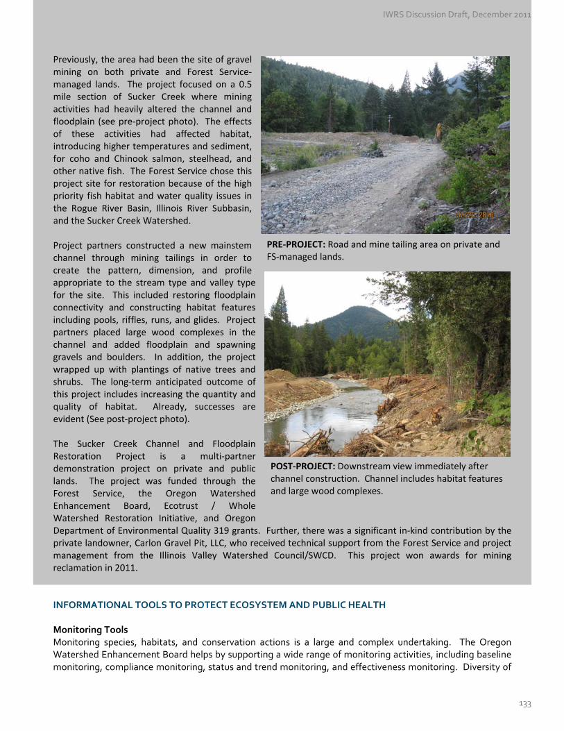
Previously, the area had been the site of gravel mining on both private and Forest Service‐managed lands. The project focused on a 0.5 mile section of Sucker Creek where mining activities had heavily altered the channel and floodplain (see pre‐project photo). The effects of these activities had affected habitat, introducing higher temperatures and sediment, for coho and Chinook salmon, steelhead, and other native fish. The Forest Service chose this project site for restoration because of the high priority fish habitat and water quality issues in the Rogue River Basin, Illinois River Subbasin, and the Sucker Creek Watershed.
PRE‐PROJECT: Road and mine tailing area on private and FS‐managed lands.
Project partners constructed a new mainstem channel through mining tailings in order to create the pattern, dimension, and profile appropriate to the stream type and valley type for the site. This included restoring floodplain connectivity and constructing habitat features including pools, riffles, runs, and glides. Project partners placed large wood complexes in the channel and added floodplain and spawning gravels and boulders. In addition, the project wrapped up with plantings of native trees and shrubs. The long‐term anticipated outcome of this project includes increasing the quantity and quality of habitat. Already, successes are evident (See post‐project photo). The Sucker Creek Channel and Floodplain Restoration Project is a multi‐partner demonstration project on private and public lands. The project was funded through the Forest Service, the Oregon Watershed Enhancement Board, Ecotrust / Whole Watershed Restoration Initiative, and Oregon Department of Environmental Quality 319 grants. Further, there was a significant in‐kind contribution by the private landowner, Carlon Gravel Pit, LLC, who received technical support from the Forest Service and project management from the Illinois Valley Watershed Council/SWCD. This project won awards for mining reclamation in 2011.
POST‐PROJECT: Downstream view immediately after channel construction. Channel includes habitat featuresand large wood complexes.
INFORMATIONAL TOOLS TO PROTECT ECOSYSTEM AND PUBLIC HEALTH Monitoring Tools Monitoring species, habitats, and conservation actions is a large and complex undertaking. The Oregon Watershed Enhancement Board helps by supporting a wide range of monitoring activities, including baseline monitoring, compliance monitoring, status and trend monitoring, and effectiveness monitoring. Diversity of
IWRS Discussion Draft, December 2011
133

monitoring approaches is essential to building an understanding of watershed health, tracking the success of watershed improvement projects, and setting restoration priorities. Below are just a few examples of the tools and activities for monitoring ecological health in Oregon. Oregon Watershed Restoration Inventory. The Oregon Watershed Restoration Inventory (OWRI) originated at the onset of the Oregon Plan for Salmon and Watersheds to track Oregonians' voluntary efforts to restore habitats for salmon and wildlife. The majority of OWRI entries represent voluntary actions of private citizens and landowners who have worked in partnership with federal, state, and local groups to improve aquatic habitat and water quality conditions. With more than 13,000 records of projects completed since 1995, OWRI is the single largest restoration information database in the Western United States. The data is used to report progress under the Oregon Plan for Salmon and Watersheds, to support effectiveness monitoring of restoration activities, and to inform watershed assessments and future restoration project planning and implementation. ODFW Oregon Plan Monitoring Programs. The Oregon Department of Fish and Wildlife’s Oregon Plan Monitoring for Coastal Basins Program comprises a number of efforts to generate basic information on salmon populations and conditions across large geographic areas of the coast. Activities include juvenile salmon population census, stream habitat assessment, salmonid life cycle monitoring via smolt trapping, and stream health monitoring via biotic index measurement. Other programs, such as adult salmon spawning surveys also contribute to monitoring efforts under the Oregon Plan.
ODF Forest Practices Monitoring Program. The Oregon Department of Forestry’s Forest Practices Act Monitoring Program provides scientific information for adapting regulatory policies, management practices, and volunteer efforts on non‐federal forestland. ODF’s resource monitoring plays a critical role in ensuring that forest operations are meeting water quality standards under the Clean Water Act. The Oregon Department of Forestry designed a Riparian Function and Stream Temperature (RipStream) Project as a joint effort between the Private and State Forests programs to determine the degree to which State and private forestry in Oregon's Coastal Range compiles with DEQ water quality standards. In particular, the project evaluates changes in stream temperature and riparian structure that provides necessary functions for the protection of fish and wildlife habitat in small and medium fish‐bearing streams. Results produced in 2011 indicate that riparian protection measures in these locations do not maintain stream temperatures similar to control conditions, and that they are inadequate to ensure that forest operations meet the state water quality standard for protecting cold water. The Department and Board of Forestry are considering revisions to the state's riparian protection standards as a result. The RipStream project will continue to provide data that informs future policy development and implementation.
Other Monitoring Programs. There are several other monitoring programs at the federal level and local level, along with programs conducted through partnerships between various stakeholders. The Pacific Northwest Aquatic Monitoring Partnership consists of federal, tribal, state partners and other parties that conduct aquatic monitoring within the watersheds, estuaries, and coastal zones of the Pacific Northwest. The Partnership’s objectives are to promote best practices for monitoring, and encourage coordination and integration of monitoring activities. Also, several federal agencies are involved in monitoring activities to meet objectives of existing plans, such as the Aquatic Conservation Strategy of the Northwest Forest Plan. Public Advisories When locally caught fish and shellfish accumulate toxic chemicals because of spills or toxic algae blooms they pose health risks to those who consume them. The Oregon Department of Environmental Quality (DEQ) establishes the level of protection needed to ensure public health, by setting water quality standards and establishing fish consumption rates that are safe for humans. DEQ recently worked with tribes, agency partners, and other stakeholders to revise the fish consumption rate and Oregon’s water quality standards.
IWRS Discussion Draft, December 2011
134

With millions of people participating in recreational activities each year, whether to harvest shellfish, catch local fish, swim or boat at a favorite lake or play along Oregon’s coastline, it is important to notify the public with any health or safety concerns. The Oregon Health Authority uses a variety of advisories to protect people living, working and playing near Oregon's beaches, rivers, lakes and other waterbodies. The state’s Public Health Division has issued several fish consumption advisories, due primarily to moderate‐to‐high mercury levels or PCB’s (polychlorinated biphenyls) found in locally caught fish. Today, there are 18 different waterbodies where fish consumption advisories exist. The Oregon Department of Agriculture and Oregon Department of Fish and Wildlife jointly issue shellfish safety closures to protect recreational shellfish harvesters from consuming clams or mussels contaminated with harmful biotoxins. Shellfish can be contaminated by natural events such as harmful algae blooms (HABs) or man‐made events such as sewage spills. Marine biotoxins ‐‐ paralytic shellfish toxins (PST) and domoic acid, are the most common reasons for shellfish closures in Oregon’s coastal waters. Biotoxins can cause mild to severe health problems for consumers. The Oregon Department of Agriculture maintains an online site with PST and domoic acid results, recent news releases, and encourages the public to call the shellfish safety hotline before harvesting. Public health and safety concerns associated with recreational use of lakes and other waters have been growing over the past several years. When toxic algae blooms are detected in the water, the Oregon Harmful Algae Bloom Surveillance (HABS) program advises the public to avoid recreational water‐contact, such as swimming, wading, or water‐skiing. Advisories are only issued for lakes, reservoirs, and rivers where a lab has verified the presence of a harmful algae bloom and only a fraction of Oregon’s many waterbodies are monitored. In 2010, twenty‐two algae‐related health advisories were issued throughout Oregon, as compared to 6 in 2005. Advisories were in effect for 272 days vs. 193 days in 2009. The increase could indicate that cyanobacteria blooms are increasing in severity but may also reflect enhanced surveillance efforts among local, state, and federal partners. The Oregon Beach Monitoring Program (OBMP) monitors recreational water quality at ocean beaches. Marine waters are tested for the bacterium enterococcus, which is an indicator of the presence of other illness‐causing organisms. Enterococcus has been shown to have a greater correlation in marine waters with swimming‐associated illnesses than other bacterial organisms. Enterococcus is present in human and animal waste and can enter marine waters from a variety of sources such as streams and creeks, stormwater runoff, animal and seabird waste, failing septic systems, sewage treatment plant spills, or boating waste. When bacteria levels are above normal, a water contact advisory is issued. The goal of the OBMP is to protect the public health by providing information about water quality, strengthening water quality standards at beaches, and promoting scientific research. The public can sign up for email alerts to receive notices when advisories have been issued at certain beaches or for presence of harmful algae blooms. The public can also find the latest water quality test results for their favorite beach online via the Oregon Coastal Atlas. DEVELOPING A MARKET FOR ECOSYSTEM SERVICES The concept of ecosystem services and markets has been recognized in Oregon law since the 2007 Oregon Legislature approved House Bill 2293. The bill states that these benefits come from the conservation, management and restoration of ecosystems generally, and that the protection of these environmental benefits in Oregon is intended to result in improvements to the region’s economy, the rural resource base, and our quality of life.
IWRS Discussion Draft, December 2011
135
Critical Issue N: Healthy Ecosystems & Public Health
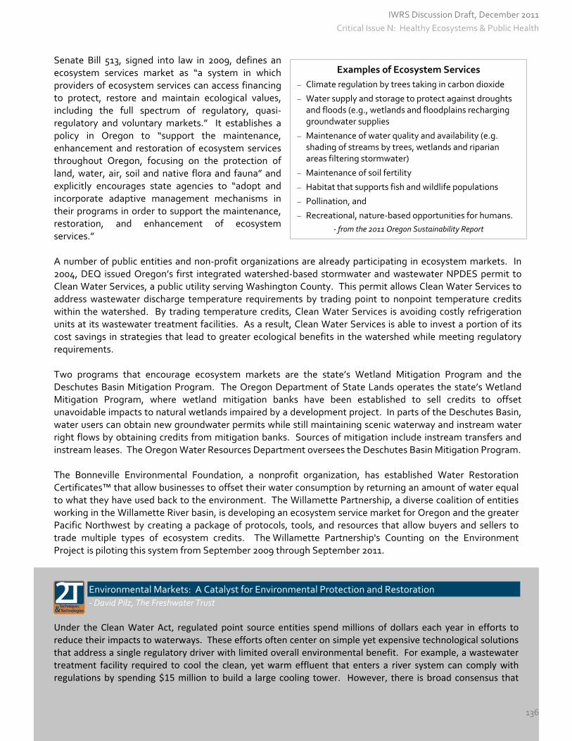
Senate Bill 513, signed into law in 2009, defines an ecosystem services market as “a system in which providers of ecosystem services can access financing to protect, restore and maintain ecological values, including the full spectrum of regulatory, quasi‐regulatory and voluntary markets.” It establishes a policy in Oregon to “support the maintenance, enhancement and restoration of ecosystem services throughout Oregon, focusing on the protection of land, water, air, soil and native flora and fauna” and explicitly encourages state agencies to “adopt and incorporate adaptive management mechanisms in their programs in order to support the maintenance, restoration, and enhancement of ecosystem services.”
Examples of Ecosystem Services
Climate regulation by trees taking in carbon dioxide
Water supply and storage to protect against droughts and floods (e.g., wetlands and floodplains recharging groundwater supplies
Maintenance of water quality and availability (e.g. shading of streams by trees, wetlands and riparian areas filtering stormwater)
Maintenance of soil fertility
Habitat that supports fish and wildlife populations
Pollination, and
Recreational, nature‐based opportunities for humans.
‐ from the 2011 Oregon Sustainability Report
A number of public entities and non‐profit organizations are already participating in ecosystem markets. In 2004, DEQ issued Oregon’s first integrated watershed‐based stormwater and wastewater NPDES permit to Clean Water Services, a public utility serving Washington County. This permit allows Clean Water Services to address wastewater discharge temperature requirements by trading point to nonpoint temperature credits within the watershed. By trading temperature credits, Clean Water Services is avoiding costly refrigeration units at its wastewater treatment facilities. As a result, Clean Water Services is able to invest a portion of its cost savings in strategies that lead to greater ecological benefits in the watershed while meeting regulatory requirements. Two programs that encourage ecosystem markets are the state’s Wetland Mitigation Program and the Deschutes Basin Mitigation Program. The Oregon Department of State Lands operates the state’s Wetland Mitigation Program, where wetland mitigation banks have been established to sell credits to offset unavoidable impacts to natural wetlands impaired by a development project. In parts of the Deschutes Basin, water users can obtain new groundwater permits while still maintaining scenic waterway and instream water right flows by obtaining credits from mitigation banks. Sources of mitigation include instream transfers and instream leases. The Oregon Water Resources Department oversees the Deschutes Basin Mitigation Program. The Bonneville Environmental Foundation, a nonprofit organization, has established Water Restoration Certificates™ that allow businesses to offset their water consumption by returning an amount of water equal to what they have used back to the environment. The Willamette Partnership, a diverse coalition of entities working in the Willamette River basin, is developing an ecosystem service market for Oregon and the greater Pacific Northwest by creating a package of protocols, tools, and resources that allow buyers and sellers to trade multiple types of ecosystem credits. The Willamette Partnership's Counting on the Environment Project is piloting this system from September 2009 through September 2011.
Environmental Markets: A Catalyst for Environmental Protection and Restoration
‐ David Pilz, The Freshwater Trust
Under the Clean Water Act, regulated point source entities spend millions of dollars each year in efforts to reduce their impacts to waterways. These efforts often center on simple yet expensive technological solutions that address a single regulatory driver with limited overall environmental benefit. For example, a wastewater treatment facility required to cool the clean, yet warm effluent that enters a river system can comply with regulations by spending $15 million to build a large cooling tower. However, there is broad consensus that
IWRS Discussion Draft, December 2011
136
Critical Issue N: Healthy Ecosystems & Public Health

river restoration efforts such as planting streamside vegetation, modifying cattle management, and leaving more water in‐stream can achieve the same or better cooling effects. Not only are these restoration projects superior ecologically, but they are also superior to engineered compliance solutions in terms of cost. Since 2006, 82 new “Total Maximum Daily Load” (TMDL) analyses have been completed for watersheds in the Pacific Northwest, with more on the way. These efforts have set new limits for temperature, nutrients, and other factors, and have created an unprecedented need for point source entities to find better compliance solutions. These new TMDLs could drive municipal and industrial wastewater facilities in the Pacific Northwest alone to spend millions of dollars over the next 10 years in treatment plant upgrades to comply with new limits on temperature and nutrients. Addressing Temperature Needs through Streamside Vegetation A system recently approved by the Oregon Department of Environmental Quality allows entities to comply with TMDL temperature allowances by purchasing restoration offsets, in this case “temperature reduction credits.” Temperature reduction credits are generated by projects that restore streamside vegetation in areas degraded by human uses, thereby shading and cooling the river naturally. The Freshwater Trust and the Willamette Partnership have developed a unique model for efficiently generating temperature reduction credits, providing a compliance solution for regulated entities while ensuring that projects are of the highest restoration quality and are monitored and maintained for 20 years or more. The Freshwater Trust is making significant strides to advance a working ecosystem services market in Oregon, with an initial focus on market trades related to stream temperature. The Freshwater Trust worked with the Port of St. Helens, Metropolitan Wastewater Management Commission (Eugene/Springfield), and the City of Medford to gain approval from Oregon DEQ to meet new temperature limits in their National Pollution Discharge Elimination System permits. This was accomplished by agreements to purchase restoration offsets from The Freshwater Trust ‐ in this case, the “temperature reduction credits” described above, generated by projects that restore streamside vegetation in degraded areas. Further, all three entities above have selected The Freshwater Trust, either through competitive bidding processes or contracting, to provide the offset credits on a long‐term basis. Other entities are under negotiation for similar outcomes. Addressing Temperature Needs through Restored Flow The Freshwater Trust is working with the National Fish and Wildlife Foundation and others to develop a protocol for relating increments of restored instream flow to decreases in water temperature. Specifically, translating cubic feet per second of restored flow to specific decreases in water temperature. Once such a protocol is established, instream flow restoration can then work in tandem with streamside revegetation to create temperature reduction credits and help regulated entities meet their TMDL temperature compliance obligations. Next Steps Environmental markets have emerged in recent years as a promising innovation for effectively increasing the pace and scale of environmental protection and restoration in the United States. Environmental markets are rooted in the measurement of “ecosystem services,” which are the crucial services provided by healthy and intact natural systems – such as purifying or cooling water or storing carbon dioxide. Determining a value for these services enables us to measure the benefits of restoration actions that restore functional health to natural systems (i.e., ecological uplift) in the same terms that we measure environmental impacts. Once we can accurately quantify and compare the ecological uplift derived from certain restoration actions, markets provide the platform for trading these units as “credits.” This creates a framework within which credits representing environmental impacts such as the release of warm but clean effluent from a wastewater treatment facility into a nearby stream, can be traded for credits representing ecological uplift such as planting trees or restoring instream flows to cool a stream.
IWRS Discussion Draft, December 2011
137
Critical Issue N: Healthy Ecosystems & Public Health

In Oregon, there are a number of regulatory and voluntary tools available for the protections of ecosystem and public health. While previous Recommended Actions focused on understanding Oregon’s water needs, the following Recommended Actions focus on meeting our water needs through technical assistance, partnership, enforcement, improved policies and programs, and markets.
RECOMMENDED ACTIONS #12.A – 12.H
Action 12.A Improve the Safety of Oregon’s Drinking Water Assist public water suppliers. Increase consultation with and education of public water suppliers on safe
drinking water regulations, contaminant standards, source water treatment options and best practices to prevent drinking water contamination. [OHA – DEQ – EPA ‐ local governments]
Focus on small public water systems. Support small public water systems (4 to 14 connections or 10 to 24
people served) by ensuring compliance with safe drinking water standards. [OHA – EPA – local governments]
Protect drinking water sources. Oregon Health Authority has mapped all public drinking water sources
(for systems with 25 connections or above). Land‐Use Planning Goal 5 requires communities to protect these drinking water sources, once they have been identified as resources. Increase collaboration among agencies regarding drinking water source pollution prevention efforts. Provide Federal Safe Drinking Water Act revolving loan funds for source water protection projects. [OHA – DEQ – EPA – DLCD – local governments]
Develop a statewide emergency response system that can quickly respond to drinking water emergencies.
[OHA – OMD/OEM – local governments] Increase Domestic Well Testing. Provide information to parties who are conducting domestic well testing,
including information about how to test wells, how to interpret the results, and what course of action to take to address contaminants. Encourage increased testing, and reporting / disclosure of results by well owners, as well as during real estate transactions. While the Domestic Well Testing Act requires collection of nitrate, coliform, and arsenic data during the sale of a property, there is no enforcement of the Act and public health officials estimate a 10 to 20 percent compliance rate. {See Action #1.A.} [OHA – OSU Extension – local governments]
Action 12.B Reduce the Use of and Exposure to Toxics and other Pollutants Finalize and implement DEQ’s Toxics Reduction Strategy. The Toxics Reduction Strategy takes a cross
media approach, focusing on air, land, and water. It includes a list of toxic chemicals as well as specific tasks to reduce the use of and exposure to such toxics through day‐to‐day agency operations in the next five years. Expand that work to other state agencies. [state agencies]
Implement the Water Quality Pesticide Management Team (WQPMT) Plan led by ODA and composed of
representatives from ODF, DEQ, and OHA, to act as a coordinating advisory team during: 1) selection and prioritization of pesticides; 2) establishment of water quality guidelines and reference points; 3) watershed vulnerability assessments; 4) design and implementation of monitoring efforts; 5) recommendation of management options; and 6) development of communication strategies. [ODA – DEQ – ODF – OHA]
IWRS Discussion Draft, December 2011
138
Critical Issue N: Healthy Ecosystems & Public Health
Support the Pesticide Stewardship Program, which sets forth a collaborative approach for monitoring current use pesticides in Oregon watersheds, as well as using the monitoring data to inform voluntary actions and technical assistance to reduce pesticide levels in water. The effectiveness of these actions is then determined by assessing trends in monitoring results over time. This program has demonstrated success in improving water quality in the limited number of watersheds where it is currently operating: the Clackamas, Pudding, Yamhill, Amazon Creek, Hood, Wasco area (Mill Creek and Fifteenmile Creek), and Walla Walla. [DEQ – ODA – local partners]
Establish and fund “take back programs” for unused and outdated chemicals. Establish and continue
pharmaceutical take‐back programs for communities, pesticide collection programs for farmers and ranchers, and hazardous waste collection events. [DEQ – EPA – public and private sector partners]
Revise purchasing practices related to toxic chemicals. Public and private entities should consider revising
their purchasing practices for soaps, cleaners, electronic devices, and other products that may include toxics to provide preference for manufacturers that commit to reducing toxic chemicals. [public and private organizations]
Continue to identify and address hazardous or contaminated sites. Sites, facilities, or structures
originating with industrial, military, transportation, energy or other uses may be in such condition that they pose a serious or imminent hazard of emitting or discharging substantial amounts of toxics or other pollutants. These should be identified and all immediate legal means and enforcement mechanisms should be employed to prevent such emissions or discharges before they occur. Provide technical and financial assistance to clean‐up already contaminated aquifers. [DEQ – EPA – public and private sector partners]
Prevent blue‐green algae from forming in lakes, streams and ponds beyond background levels. Blue‐green algae, or cyanobacteria, can irritate skin, cause liver malfunction, or affect the nervous system. They thrive in warm, stagnant waters that have significant concentrations of nutrients, particularly phosphorus. Steps should be taken to control phosphorous from entering the water body through fertilizer runoff, septic systems, and other sources. Additional prevention techniques include increasing water flow through the lake or reservoir, artificial circulation of water within the reservoir, and improved watershed management. [DEQ – OHA – EPA – local governments – public and private sector partners]
Monitor recreational waters and inform the public when contaminants are present, such as fecal bacteria and cyanobacteria (blue‐green algae). While the Beach Act provides funding from the U.S. Environmental Protection Agency to monitor ocean beaches for fecal contamination and the National Oceanic and Atmospheric Administration provides funding to monitor the coast and recreational shellfish for cyanobacteria, there is no on‐going funding commitment to monitor freshwater recreational areas and inform the public regarding exposures. [OHA – DEQ]
Action 12.C Implement Water Quality Pollution Control Plans
Continue to develop and implement Total Maximum Daily Load plans for waterbodies that do not meet water quality standards. Build upon DEQ’s recent completion of 1153 TMDLs in Oregon. Develop TMDLs for remaining waterbodies and pollutants on Oregon’s 303(d) list and those added in the future, in accordance with the federal Clean Water Act. Review and update already existing TMDLs. Revise wastewater permits to meet wasteload allocations and provide oversight to ensure that TMDL implementation measures are effective. [DEQ and Designated Management Agencies]
Address Nonpoint Sources of Pollution. Continue to assist landowners with the management of pollution
IWRS Discussion Draft, December 2011
139
Critical Issue N: Healthy Ecosystems & Public Health

across all land uses (e.g., urban, agriculture, forestry) to ensure the protection of surface water and groundwater quality. Build upon the existing work done through the Forest Practices Act and Agricultural Water Quality Management Plans, particularly related to temperature, sedimentation, and contamination of surface water. Typical agricultural water quality management approaches can include riparian buffer zones, capturing animal manure during wet seasons and spreading it as fertilizer during cropping season, irrigation scheduling, and soil moisture monitoring. Increase monitoring to determine the efficacy of these approaches. [DEQ‐ ODA – ODF – local governments]
Ensure effective management and oversight of stormwater in urbanized‐areas through the implementation of MS4 permits, TMDL Implementation Plans for Urban Designated Management Agencies, or a comparable voluntary plan. [DEQ – local governments]
Assist Communities with Septic System Challenges. Failing septic systems increase the risk of
contamination of both surface water and groundwater and can be a public health hazard. Provide technical and funding assistance to landowners who need to replace or repair failing septic systems. Provide technical and funding assistance to communities wishing to address public health or water quality problems associated with individual subsurface sewage disposal systems. {See Action #10.A}. [DEQ – OHA – IFA – federal and local partners]
Action 12.D Improve Watershed Health, Resiliency, and Capacity for Natural Storage Improve Riparian Conditions. Riparian areas provide habitat, maintain stream flows, provide natural
flood control, improve water quality, control erosion, and maintain the integrity of the stream channel. Encourage voluntary participation in restoration projects and secure funding to provide incentives for restoration. [ODFW – OWEB – DEQ – WRD]
Maintain Forested Areas. Healthy, functional, and resilient forests are critical to protecting the integrity
of Oregon’s water resources. Promote the maintenance of forestland, both public and private, in forest uses and promote the establishment of new forests as key elements in promoting high quality water and protection of soil productivity. (See Oregon Department of Forestry’s 2011 “Forestry Program for Oregon” for more details.) [ODF – USFS]
Preserve Wetlands. Protect and restore surface water and groundwater functions that contribute to
wetlands. Develop a rapid assessment methodology, to determine storage capacity and system health of wetlands and streams. Encourage regulators, planners, and communities to use these tools to make permitting decisions, evaluate the effectiveness of mitigation and restoration practices, and bolster their efforts under Statewide Planning Goal 5. [DSL – USACE – US EPA – local government]
Restore Floodplain Functions. Develop a statewide floodplain policy to set the framework for regulation
and permitting work. Encourage voluntary participation in restoration projects and secure funding to provide incentives. Implement Action 3.8 in ODFW’s Conservation Strategy to reconnect rivers and streams to their floodplains; restore stream channel location and complexity; remove dikes and revetments; allow seasonal flooding; restore wetland and riparian habitats; and/or remove priority high‐risk structures within floodplains, where possible. [DSL – DLCD – ODFW – OWEB – FEMA – local government].
Action 12.E Develop Additional Instream Protections Designate Scenic Waterways. Recommend the designation of additional rivers or segments of rivers as
scenic waterways, where appropriate to protect recreation, fish, and wildlife uses. [OPRD ‐ WRD]
IWRS Discussion Draft, December 2011
140
Critical Issue N: Healthy Ecosystems & Public Health

Establish additional instream water rights, where appropriate, to protect flows. For example, at the
completion of a TMDL, the Department of Environmental Quality may prepare and submit to WRD an instream water right application for the flow amount used to calculate the TMDL. Coordinate new instream water right applications to meet multiple water quality and flow needs. Work to resolve the Water Resources Department’s protested instream water right applications. [DEQ ‐ ODFW – OPRD – WRD]
Expand the use of voluntary programs to restore streamflows, such as instream leases, instream transfers,
and allocation of conserved water program. [WRD – local partners] Expand the geographic range of flow restoration efforts. Today, instream flow restoration activities
predominantly occur in a handful of basins, however, streamflow restoration needs have been identified in all 18 basins throughout the state. Develop and implement strategies that target watersheds with the highest instream flow needs, extending streamflow restoration beyond current efforts, on both public and private lands. [Oregon Plan Core Team, Watershed Councils, Soil & Water Conservation Districts, public and private partners]
Action 12.F Prevent and Eradicate Invasive Species Prevent the spread of invasive species; support efforts by local, state and federal agencies, including the
use of boat inspections stations. Support the Oregon Conservation Strategy’s six statewide actions aimed at preventing new introductions,
and the scale and spread of infestations. They are:
~ Focus on prevention through collaborative efforts and increased public awareness and reporting (OCS Action 2.1).
~ Develop early response mechanisms to facilitate swift containment of new introductions, using site appropriate tools (OCS Action 2.2).
~ Establish a system to track location, size, status of infestations of priority invasives (OCS Action 2.3). ~ Focus on eradication of invasive species in Strategy Habitats and other high priority areas where there
is a clear threat to ecosystems and a high probability of success (OCS Action 2.4). ~ Develop an invasive species implementation tool that evaluates the ecological impact and
management approaches for invasive species identified as priorities in the Conservation Strategy (OCS Action 2.5). [ODA – Ore Invasive Species Council]
~ Develop and test additional techniques to deal with invasives and share information with landowners and managers (OCS Action 2.6).
Implement and enforce ballast water management regulations to reduce the risk of introducing new
aquatic invasive species. The discharge of ballast water, used to provide vessel stability, may introduce aquatic non‐indigenous species into Oregon waterways, potentially resulting in ecological damage. [DEQ]
Action 12.G Protect and Restore Instream Habitat and Habitat Access for Fish and Wildlife Build upon existing ecological planning and restoration efforts. Continue to implement and build upon the
successful collaborative efforts of the Oregon Plan for Salmon and Watersheds, Northwest Power and Conservation Council’s Strategy for Salmon, Conservation and Recovery Plans and Biological Opinions, and the Oregon Conservation Strategy. Strengthen and forge new partnerships through the Integrated
IWRS Discussion Draft, December 2011
141
Critical Issue N: Healthy Ecosystems & Public Health
Water Resources Strategy. [Oregon Plan Core Team – local communities – federal partners – citizens]
Remove fish passage barriers and prevent fish from entering diversions. Continue to focus efforts on removing fish passage barriers (e.g., replacing culverts with bridges, installing larger culverts, construction of fish ways, and stabilization of road fill material, installing fish screens, and retiring obsolete and push‐up dams). [ODOT, Oregon Plan Core Team, Watershed Councils, Soil & Water Conservation Districts, public and private partners]
Action 12.H Assist in the Development of Ecosystem Services Markets Assist in the research and development of ecosystem services markets in Oregon. Build upon the
state’s policy of ecosystem services markets, by continuing to develop, define, and explore how these markets could be used to meet both regulatory and voluntary needs in Oregon. [OWRD – DEQ – DOFW – DSL – Federal – Tribes – local and private partners]
~ Assess potential for water quality projects to meet various regulatory requirements, including temperature and
nutrients. Develop protocols for translating water quality projects into ecosystem credits. These protocols will help DEQ and point and non‐point source dischargers make more informed choices about how to meet water quality requirements in more cost‐effective ways (e.g., using riparian shade restoration to help achieve heat
reduction requirements). [DEQ – DSL– local communities – private partners] ~ Develop tools and protocols for translating flow restoration actions into ecosystem credits. Build upon the
“stream functional assessment” under development by DSL, the U.S. Army Corps of Engineers, U.S. Environmental Protection Agency and other partners to include stream flow in function‐based accounting strategies. [State and Federal agencies – private sector]
IWRS Discussion Draft, December 2011
142
Critical Issue N: Healthy Ecosystems & Public Health

Appendices
IWRS Discussion Draft, December 2011
143
APPENDIX A: THE PROCESS OF DEVELOPING THE IWRS
Appendix A
The Process of Developing the IWRS
Project Timeline Development of Oregon’s Integrated Water Resources Strategy occurred over a three‐year period, broken into five phases. From the beginning, public outreach and involvement and a scientific foundation remained at the core.
Phase I: Setting
the Stage (2009)
Phase II: Identifying Water Resource Needs
(Spring & Summer 2010)
Phase III: Developing
Recommended Actions
(2010‐2011)
Phase IV: Producing Oregon’s 1st
Integrated Water Resources Strategy
(2012)
Phase V: Implementation and
Evaluation (2012‐17)
Phase I: Setting the Stage This Phase, which extended through December 2009, included fundamental activities that continued to be built upon throughout the entire process. Activities that occurred during Phase I are described below. 1.1 Develop the Problem Statement. During Phase I, the Departments, with help from Water Resources Commissioners, partners, and stakeholders, developed a set of issue papers to convey the urgency of planning for water. They are, in essence, the “problem statement,” and describe the status of Oregon’s water quantity, water quality, and ecosystems today. More than 300 stakeholders and the public reviewed and commented on these draft papers throughout the project, either electronically, by mail, or verbally during Water Resources Commission meetings. The topics of these papers grew out of the themes identified during the 2008 Water Roundtables hosted by Oregon State University and Oregon Sea Grant and include: water quantity, water quality, ecology and ecosystems, economic development, culture and community, and the implications of climate change. Revised issue papers were made publicly available in November 2010. The public was given an opportunity to comment on the papers through March 2011. 1.2 Design Overall Process. A preliminary workplan for 2009 – 2012 was developed and included a description of the statutory foundation, definitions, roles and responsibilities, project timeline, public involvement strategies, process overview, meeting calendar, and a sample table of contents for Oregon’s Integrated Water Resources Strategy. The Water Resources Commission first reviewed and commented on the workplan during its September 2009 meeting, while at the same time it was made available to partners, key stakeholders, and the public for review and comment. Like the issue papers, the workplan was available for public comment throughout the duration of the project. 1.3 Engage the Public. During 2009, the Departments worked with partners and stakeholders to design a public involvement plan to identify multiple opportunities to disseminate information widely and gather input. The public involvement plan described the key messages to share with the public and the communication challenges to be expected when developing the Strategy:
IWRS Discussion Draft, December 2011
144
Key Messages
The purpose of Oregon’s Integrated Water Resources Strategy is to develop an action agenda for how Oregon’s water resource needs will be met now and in the future.
An integrated strategy will address water quantity, water quality, and ecological needs.
The Water Resources Commission has ultimate responsibility for adopting the Strategy.
The Strategy may contain policy, legislative, and budget recommendations to the Oregon Legislature.
Partnerships with and among Oregon communities will be critical to meet Oregon’s future water needs.
Communication Challenges
Water is of universal concern; outreach to all interested parties in Oregon will be a challenge.
Water users and advocates worry that recommendations might benefit one group at the expense of another.
Oregon is generally regarded as a “wet” state. However, communities face water scarcity today, depending on location, time of year, water source, and beneficial uses. Conveying the seriousness of water conditions today and into the future will be a challenge.
Looming pressures on our water resources, including population growth and climate change, are not yet “real” in the personal lives of many Oregonians. Planning for these abstract concepts presents a challenge.
The state of Oregon historically has not invested much funding in water resource management, programs, or infrastructure. A successful strategy, involving scientific work, public outreach, and implementation, may necessitate greater financial investment.
The public involvement plan outlined specific activities and communication methods using (1) face‐to‐face interaction, (2) traditional media, (3) and electronic outreach. As part of the plan, the Project Team committed to host community meetings, stakeholder workshops, and to designate time for public comment during Commission meetings and Policy Advisory Group meetings. The public involvement plan directed staff to utilize agency field offices, as well as local and state media outlets, to advertise events, post project updates, and distribute information to the public. The public involvement plan also involved creation of a project website, meeting calendar, an electronic listserve, and a direct email address to the Project Team. 1.3 Develop Institutional Capacity and Organizational Structure. As part of House Bill 3369, the Oregon Legislature authorized funding for the Water Resources Department to fill two positions to help develop the strategy, a science coordinator and a policy coordinator. Agency directors also appointed senior staff to a “Project Team” and an “Agency Advisory Group,” and appointed 18 citizen‐members to a “Policy Advisory Group.” A “Federal Liaison Group,” consisting of federal water and land‐use agencies was also created. Information about each groups’ role is described in the following section titled “Institutional Structure.” This project has relied heavily on the volunteer and in‐kind services of partners and stakeholders for facilitation, process consulting, materials, refreshments, and facilities. Phase II: Identifying Water Resource Needs This phase ran from January through August 2010 and focused heavily on public input, using a series of community and stakeholder meetings, to identify and describe critical issues and potential solutions. Meeting details, results, and photos are available on‐line. 2.1 Identify Critical Issues. During 2010, project participants identified numerous issues that if addressed, could help Oregon better understand and meet its water needs. This work took place through facilitated
IWRS Discussion Draft, December 2011
145
discussions during open houses, advisory group meetings, stakeholder workshops, and surveys. The four key agency directors, Project Team, and the Policy Advisory Group pared down the list of critical issues. 2.2 Address Public Comment (Issue Papers and Workplan). The Project Team reviewed public comments received on the draft issue papers and preliminary workplan and addressed comments through revisions to these documents. The Project Team brought areas of contention to the Water Resources Commission and the Policy Advisory Group for further discussion and direction. Phase III: Developing Recommended Actions 3.1 Submit Progress Report to the Legislature. During Phase III, the Oregon Water Resources Department, Oregon Department of Environmental Quality, Oregon Department of Fish and Wildlife, and the Oregon Department of Agriculture provided a progress report to the 76th Legislative Assembly in February 2011. 3.2 Develop Draft Recommended Actions for Public Review & Comment. In June 2011 the Project Team released a document describing an initial set of draft recommended actions designed to address to the most critical issues facing Oregon’s water resources. The document consisted of a series of 12 bulletins that included brief background information and a list of online resources. The bulletins covered several issues: instream and out‐of‐stream water needs, water resources/supplies, water and energy, climate change, water and land‐use, infrastructure, education and outreach, funding, place‐based approaches, water management, ecosystem health and public health. The purpose of the bulletins was to continue communicating and engaging with Oregonians during development of the Strategy. The public and various stakeholder groups were encouraged to offer comments on the initial list of actions. The Project Team accepted comments through August 31, 2011. In addition to the discussion held by the Policy Advisory Group on July 19, the Project Team received a significant amount of input from individuals, as well as public and private sector organizations. In all, the Project Team received comments from nearly 50 individuals and organizations, including some who had not previously participated in the project. The Project Team engaged in an active outreach effort to elicit these comments. This included workshops with stakeholders throughout the summer. Workshops conducted after the June 2011 release of the draft recommended actions included the Board of the Oregon Water Resources Congress, the quarterly Natural Resources Cluster meeting of the Legislative Commission on Indian Affairs (Oregon’s nine federally recognized tribes comprise this group), the annual meeting of the Oregon Planning Institute, and more. The Project Team invited participation through its electronic mailing list and contacted the same local papers who advertised the IWRS Open House events in 2010. The Project Team also placed notices in membership newsletters (e.g., the League of Oregon Cities’ summer newsletter) inviting participation. 3.3 Revamping Recommended Actions. During Fall 2011, the advisory groups continued to work on identifying and scoping potential recommended actions to address the critical issues, and producing a December 2011 Discussion Draft for public review. Phase IV: Producing Oregon’s First Integrated Water Resources Strategy Work under Phase IV is aimed at preparing, adopting, and submitting Oregon's first Integrated Water Resources Strategy during 2012. The Project Team plans to review the document with the public, stakeholders, advisory groups, and boards and commissions through a number of electronic and face‐to‐face means, including public hearings.
IWRS Discussion Draft, December 2011
146

In 2012, the Project Team will present the strategy to the Water Resources Commission for notification of other Boards and Commissions. Boards and Commissions will be asked for a formal endorsement of the Strategy. Following review and adoption by the Water Resources Commission, the Strategy will be delivered to the Oregon Legislature in time for the 2013 Legislative Session.
Phase V: Implementation and Evaluation This is an iterative process and successfully meeting Oregon’s water needs will mean constantly asking “what if” questions and preparing to adapt to changing circumstances and environments. Upon adoption of Oregon’s first Integrated Water Resources Strategy, the Project Team will embark on a process to implement the recommended actions, and to evaluate the process, identifying both the lessons learned and improvements needed for the next iteration. The Strategy is due to the Oregon Legislature by December 31, 2012, with five‐year updates occurring thereafter. Legislators, agencies, and partners will also have opportunities during this phase to evaluate the implementation and effectiveness of the Recommended Actions included in the Strategy. Institutional Structure The following chart demonstrates the flow of information and how decisions were made during the development of the Strategy. The Oregon Water Resources Department was ultimately responsible for developing the Strategy. Information passed through the Project Team as part of the IWRS record and for further distribution. Public comments were regularly posted to the project website and, at any time, interested parties could comment either verbally or in writing to Project Team members. Information Flow Chart
Policy
Advisory
Group
Federal
Liasion
Group
Environmental Quality Comm.
Fish & Wildlife CommissionBoard of Agriculture:
Notification & Consultation
Oregon
Legislature
Governor's
Office
Agency Advisory
Group
Senate and House
Policy
Committees
Water Resources
Commission (WRC):
Adoption of Strategy
Public‐Private Partnerships
Interested Public
ProjectTeam
Four Agency Directors:Water Resources Dept.
Dept. of Environmental Quality
Dept. of Fish and Wildlife
Dept. of Agriculture
Government‐to‐Government(9 Federally Recognized Tribes)
Key Stakeholders
Project Team The Project Team, led by the Water Resources Department, managed the development of the Integrated Water Resources Strategy. The team was comprised of senior staff from four natural resources agencies at state level.
IWRS Discussion Draft, December 2011
147
The Project Team met regularly to evaluate progress and assign tasks. These include preparing materials and agendas for advisory group meetings and public meetings. The Project Team partnered with stakeholders to host meetings and workshops, and with academic institutions to conduct related research on a variety of fronts. In addition to developing the website, mailing list, briefing materials, and meetings, the Project Team collected and documented recommendations from advisory groups, partners, stakeholders, and other interested parties. Throughout the process, the Project Team provided project updates to the Governor’s office, Oregon Legislature, advisory groups, stakeholders, partners, and the public, as well as to the four primary Commissions: the Water Resources Commission, Environmental Quality Commission, Fish and Wildlife Commission, and Board of Agriculture.
Governor's Office and Oregon Legislature Regular reports to these entities provided formal opportunities to update policymakers and receive policy guidance on the Strategy.
Boards and Commissions The authorizing statutes require the Water Resources Commission to notify the Environmental Quality Commission, Fish and Wildlife Commission, and Board of Agriculture prior to adoption of the Integrated Water Resources Strategy. These and other Boards and Commissions have been engaged since the early stages of the process, hosting discussions during regularly scheduled public meetings.
Policy Advisory Group (PAG) The Policy Advisory Group was comprised of 18 citizen members, appointed for their experience in the water arena and their commitment to leadership in the IWRS process. Their role was to provide feedback and to make recommendations to the agency Directors. In particular, they helped to identify and prioritize the “critical issues” and “recommended actions” featured in the IWRS.
Agency Advisory Group (AAG) The Agency Advisory Group was comprised of senior staff from 18 natural resource and economic development state agencies, and the Governor’s office. This group develops much of the technical materials, maps, statistics, and analysis used by the Policy Advisory Group and agency directors in the development of the IWRS.
Federal Liaison Group (FLG) The Federal Liaison Group included nine federal agencies with diverse responsibilities in the area of water supply, water quality, land management, and fish and wildlife in Oregon. These agencies named liaisons that provided policy and technical input, and peer review, to the Strategy.
Government‐to‐Government Relations The nine federally recognized Tribes of Oregon receive assistance from the Legislative Commission on Indian Services in their partnerships with the State of Oregon. On November 19, 2009, the Legislative Commission hosted a Government‐to‐Government State‐Tribal Water Forum in which eight of the Tribes described their history, perspective, cultural values, and use of water resources. These perspectives were recorded and are included as part of the project archives. The Legislative Commission has hosted the Project Team on subsequent occasions in order to stay engaged in the development of the Strategy. One member of the Confederated Tribes of the Umatilla Indian Reservation served on the Policy Advisory Group. In addition, the Tribes actively participated in the open house events.
Key Stakeholders Key stakeholders included institutions and associations that helped immensely with outreach efforts. Key stakeholders represented a wide variety of geographies, interests, and number of members. They included
IWRS Discussion Draft, December 2011
148

agricultural, municipal, environmental, business, local government, and other interests, and typically have members or donors who are interested in water‐related issues. The Project Team appreciated the assistance stakeholders provided, such as serving as a communication link to their members and colleagues. The Project Team met with many of these stakeholder groups to provide briefings and conduct workshops related to the Strategy.
Interested Public Early on, the Project Team developed a public involvement plan that describes the opportunities for the interested public to gather and receive information. These opportunities ranged from face‐to‐face interactions (public meetings) to print media (newspapers, newsletters, and fliers) and electronic communications (the project website, mailing list, and email). The best opportunities for public interaction occurred during the 2010 open house events, surveys, and formal public comment periods. Open Houses and Public Input Open houses, held during the spring of 2010, included one virtual and eleven face‐to‐face events. The events were held at the following locations:
Gresham, March 31
Ontario, April 7
Umatilla, April 8
Bandon, April 22 Tillamook, April 28
Medford, May 11
Klamath Falls, May 12
Redmond, May 13
Burns, May 25
Salem, June 8
Eugene, June 10
The open house events averaged about 75 participants each, and included members of the public (including families), elected and appointed officials, public and private organizations, and water professionals. Commission / Board members and Department staff from the four key agencies presented materials and hosted a “project showcase” that demonstrated local, state, tribal, and federal water management practices already underway in Oregon. A “Kids Activity Center” included water‐related word finds and coloring activities for younger participants. A display gallery of 18 mounted maps served as a visual representation of challenges and opportunities for water resources in Oregon today.
Facilitators from all eleven communities volunteered their time and led the open house brainstorming sessions. Dozens of public and private organizations donated materials, displays, facilities, refreshments, and time to ensure the success of these outreach events. During these events, participants were asked to identify the key water issues facing their communities and the solutions they would like to see pursued. The Project Team posed these same questions in more than 30 stakeholder workshops around the state to solicit input. An on‐line survey yielded another 80 responses. Through these outreach efforts, the Project Team reached more than 1,000 Oregonians, inviting their input into this process. Briefings and workshops included:
Various State & Federal Agencies, Boards, Commissions
Alliance for Democracy
American Public Works Association – Oregon Chapter
American Water Resources Association – Oregon Chapter
American Water Works Assoc. – Water Resources Comm.
Association of Oregon County (AOC) Planning Directors
Association of Oregon Counties (AOC) Annual Summit
Council of State Governments
Deschutes Water Alliance
Environmental / Conservation Groups
League of Oregon Cities Water Policy Committee
Legislative Commission on Indian Services
Lions Convention Network of Watershed Councils Annual Gathering
Oregon Association of Cattlemen Annual Meeting
Oregon Association of Clean Water Agencies
Oregon Association of Conservation Districts Board
Oregon Association of Nurseries
Oregon Business Council Water Committee
Oregon Interim Legislative Committees
Oregon Farm Bureau Water Committee
Oregon Girls’ State
Oregon Groundwater Association – Annual Meeting
IWRS Discussion Draft, December 2011
149
Oregon League of Women Voters Annual Meeting
Oregon Planning Institute
Oregon State Association of RC&D Councils
Oregon Sustainability Board
Oregon Water Law Annual Conference
Oregon Water Resources Congress
Oregon Water Utilities Council
Portland BaseCamp 2010: Socially Responsible Investment
Tillamook Soil & Water Conservation 2009 Annual Meeting
State‐Tribal Water Forum
Tualatin Riverkeepers and Tualatin R. Watershed Council
Water for Life Annual Meeting
Western States Engineers
Yamhill Soil & Water Conservation District
Additional input opportunities included public comments collected through traditional means and through the email address, [email protected]. All of these venues provided an opportunity to understand and address concerns and questions from the public. At the conclusion of these open houses and workshops, the Project Team received very positive feedback from participants who appreciated the time and energy invested in gathering public input. This input is summarized in a 40‐page Results document, available on the project website.
IWRS Discussion Draft, December 2011
150

APPENDIX B: STATE AND FEDERAL POLICIES UNDERPINNING WATER MANAGEMENT IN OREGON
Appendix B
State and Federal Policies Underpinning Water Management in Oregon
These state and federal policies are mentioned earlier in the document. Appendix B provides more detail. Policies and Laws – Water Quantity Oregon’s Water Code Under Oregon law, all water is publicly owned. With some exceptions, irrigators, cities, businesses, and other water users must obtain a permit or water right from the Water Resources Department to use water from any source‐whether it is underground, or from lakes or stream. Generally speaking, landowners with water flowing past, through, or under their property do not automatically have the rights to use that water without a permit from the Department. The Doctrine of Prior Appropriation Oregon’s water laws are basin on the principle of prior appropriation. This means the first person to obtain a water right on a stream is the last to be shut off in times of low streamflows. In water‐short times, the water right holder with the oldest date of priority can demand the water specified in their water right regardless of the needs of junior users. In Oregon, the prior appropriation doctrine has been law since February 24, 1909, when passage of the first unified water code introduced state control over the right to use water. Oregon’s Water Code contains four fundamental provisions:
Beneficial Purpose without Waste. Surface or groundwater may be legally diverted for use only if it is used for a beneficial purpose without waste.
Priority. The water right priority determines who receives water in a time of shortage. The more senior the water right, the longer water is available in a time of shortage.
Appurtenancy. Generally, a water right is attached to the land described in the right, as long as the water is used. If the land is sold, the water right goes with the land to the new landowner.
Must be used. Once established, a water right must be used as provided in the right at least once every five years. After five consecutive years of non‐use, the right is considered forfeited and is subject to cancellation. There are some exceptions to this law.
Exempt Uses Some uses of water are exempt from the requirement to obtain a permit. These are called “exempt uses” and are defined in ORS 537.141 for surface water and ORS 537.545 for groundwater. These uses are exempt from applying for a water right permit, but must use water beneficially and without waste. Withdrawing water under the exemption carries the same weight as a water right and does have a priority date. An exempt use is subject to the same privileges and restrictions as any water right permit or certificate. Exempt uses are subject to state water law. In fact, the Department has the authority to regulate, reduce, or stop water withdrawals when they interfere with prior or “senior” water rights.
IWRS Discussion Draft, December 2011
151

Oregon has about 300,000 exempt‐use wells, with several hundred more drilled each year. Wells supplying water for exempt groundwater uses must comply with minimum well construction standards for the construction, maintenance, and abandonment of any well. The ever‐increasing number of exempt use wells has resulted in calls for a closer policy look, including a better understanding of their demands on the resource, their potential for interference with senior water rights, and their overall effect on the health of Oregon’s groundwater system. Currently, sufficient data to understand how these wells are affecting groundwater availability and surface water sources is lacking. The most common exempt uses of groundwater include: (1) Group or single domestic use, up to 15,000 gallons per day; (2) Irrigation of lawn and/or non‐commercial garden up to ½ acre; (3) Single industrial or commercial purpose not to exceed 5,000 gallons per day; and (4) Stock watering. The most common exempt uses of surface water include: (1) natural springs that do not flow off the property where it originates; (2) stock watering; (3) salmon egg incubation; (4) fire control; (5) forest management; (6) certain land management practices; and (7) rainwater collection from an artificial impervious surface. The Evolution of Water Law Oregon’s water code has continued to evolve over the years. In 1955, the Legislative Assembly adopted the state Ground Water Act, authorizing the state’s management of ground water resources. Also in 1955, the authorization of Basin Planning shifted Oregon's focus to planning and management of water resources at the Administrative Basin level. The 1987 Instream Water Right Act has allowed Oregon to protect more water instream than any other western state. The Allocation of Conserved Water Program—revamped in 1993—allows water users to apply conserved water to new lands, new uses, and instream uses, based on statutory parameters. Federal partners have a variety of policies also designed to address water quantity issues. Some include: BOR: Ensure Continued Delivery of Water and Power Benefits Reclamation is ensuring continued delivery of water and power benefits to the Bureau’s Projects in Oregon, in conformity with contracts, statutes, and agreements. Programs which support this effort include AgriMet and Hydromet. Reclamation operates and maintains AgriMet http://www.usbr.gov/pn/agrimet/, a satellite‐based network of automated agricultural weather stations which are dedicated to regional crop water use modeling, agricultural research, frost monitoring, and integrated pest and fertility management. Reclamation also operates Hydromet http://www.usbr.gov/pn/hydromet/, a network of automated hydrologic and meteorological monitoring stations located throughout the Pacific Northwest, to provide timely water supply status for river and reservoir operations. Many Hydromet stations in Oregon also have temperature data collection capabilities. BOR: Support the New Energy Frontier Recognizing the current national emphasis on renewable energy and its extensive existing water infrastructure systems, Reclamation has produced the Hydropower Resource Assessment at Existing Reclamation Facilities Report (2011) to assess hydropower development at existing facilities to contribute to nationwide renewable energy strategies. http://www.usbr.gov/power/ Using updated energy technology, the Green Springs Transformer Replacement and Switchyard project will replace two antiquated transformers with one efficient transformer to save energy and increase reliability. Many existing Reclamation and partners’ facilities in Oregon have been filed on for proposed hydropower generation facilities. Close coordination with these third‐party entities will be required. Additionally, Reclamation’s PN Region is home to a unique program, the Federal Columbia River Power System (FCRPS). The FCRPS is a series of hydropower projects on the Columbia and lower Snake rivers that
IWRS Discussion Draft, December 2011
152
collectively provide about 30 percent of the electricity used in the Pacific Northwest. The Bureau of Reclamation and US Army Corps of Engineers own and operate the dams in the FCRPS. BOR: Operate and Maintain Projects Safely and Reliably Reclamation protects the public and the environment through the adequate maintenance and appropriate operation of its facilities. Programs include: BOR: Operations and Maintenance (O&M) Program To preserve aging infrastructure, Reclamation conducts regularly‐scheduled inspections, ongoing dam safety evaluations, and dam instrumentation data collection and review. Periodic and comprehensive facility reviews and dam safety documentation contain recommendations for maintenance, dam safety investigations, and improvements. The current efforts only preserve the infrastructure in its current condition; they do not provide repair, replacement, or upgrades. Project beneficiaries often do not have the amount of readily available funds required to pay for their portion of major modifications. BOR: Safety of Dams Program The primary emphasis of the Safety Evaluation of Existing Dams program is to perform site evaluations and to identify potential safety deficiencies on Reclamation and other Interior bureaus' dams. The basic objective is to quickly identify dams which pose an increased threat to the public, and to quickly complete the related analyses in order to expedite corrective action decisions and safeguard the public and associated resources. BOR: Canals in Urbanized Areas Program Reclamation uses a triage method for inspecting canals in (1) water condition; (2) dewatered condition; and (3) by aerial flight. These inspections provide important data to help ensure that canal reaches are properly operated and maintained and continue to provide authorized project benefits. BOR: FCRPS Asset Management Plan This plan provides means to identify, prioritize, and remedy aging hydropower infrastructure within the FCRPS. BOR: Umatilla Basin Water Supply Study This study identifies and evaluates measures to supply water to help resolve CTUIR surface water rights claims, including water to enhance instream flows. The Interior Water Rights Assessment Team is completing its report, which will display the alternatives developed by the study team and stakeholders. BOR: Water Conservation Field Services Program The Water Conservation Field Services Program (WCFSP) provides incentives for improved water conservation in the form of technical and financial assistance (http://www.usbr.gov/waterconservation/index.html). The WCFSP also assists non‐traditional partners in pursuing conservation activities when the benefits from these activities can be shared by Reclamation water systems or Reclamation’s water users. Water conservation activities enable Reclamation water contractors to reduce water use, helping to increase the reliability of water supplies in subsequent years. Decreasing water usage may be even more important in changing climate scenarios that indicate increasing weather variability. This program, which requires non‐Federal cost share, continues to seek means to improve the efficiency of water delivery by conservation projects and water storage that will in turn increase delivery reliability. Examples include providing financial incentives for developing and updating water conservation plans, piping and lining canals, and automating headgates, among others.
IWRS Discussion Draft, December 2011
153
Technical assistance can include water measurement, seepage studies, design of conservation measures such as automated headgate structures, SCADA systems, piping, diversions, and water conservation education workshops. In fall 2011, WCFSP program assistance enabled construction of restoration and reinforcement features along a stretch of eroding banks of the Powder River within Baker City. Other recent projects in eastern and central Oregon include lateral piping, canal lining, water measurement improvements, computerized water accounting, and automation of canal structures. BOR: WaterSMART WaterSMART (http://www.usbr.gov/WaterSMART/) is a key component of Reclamation’s plan to implement the SECURE Water Act, Subtitle F of Public Law 111‐11. Reclamation encourages and supports local entities to develop competitive proposals for WaterSMART grants, which require a 50 percent non‐Federal cost share. Additional programs and associated funding support are available through Reclamation, such as the Rural Water Supply Program http://www.usbr.gov/ruralwater/index.html, authorized through Public Law 109‐451, the Rural Water Supply Act of 2006. This program has not yet been utilized in Oregon. BOR: WaterSMART System Optimization Review Grants A System Optimization Review is a look at system‐wide efficiency focused on improving operations and efficiency of a water delivery system, water district, or water basin. It results in a plan of action. Ochoco Irrigation District was a successful recipient in 2010 of a two‐year System Optimization Review agreement. The Powder Valley Water Conservation District was selected for receipt in 2011 but withdrew prior to initiation due to cost‐share issues. BOR: WaterSMART Water and Energy Efficiency Grants This program encourages local entities with water delivery authority to develop and implement projects that save water, improve energy efficiency, address endangered species and other environmental issues, and facilitate transfer to new uses (http://www.usbr.gov/WaterSMART/). Some examples of activities include installation of SCADA equipment to better monitor and control distribution, piping or lining of canals to reduce seepage, installation of in‐canal hydropower facilities, and piping open canals to provide gravity flow pressure for sprinkler irrigation. Ongoing and new recipients of six separate agreements are the Three Sisters, Tumalo, Owyhee, and Umatilla Irrigation Districts. BOR: WaterSMART Basin Studies This program provides funding for comprehensive water studies that define options for meeting future water demands in river basins in the western United States where imbalances in water supply and demand exist or are projected. The Hood River Basin Study was funded as a two‐year study in 2011 and will proactively resolve potential conflict by bringing together stakeholders to conduct a study to best use the available water in the basin. BOR: Title XVI Title XVI of Public Law 102‐575 is a water reclamation and re‐use program included under WaterSMART. It provides funding for planning studies and the construction of water recycling projects, on a project specific basis, in partnership with local governmental entities. The City of Hermiston has successfully planned a study under the program, but has not yet obtained construction authorization and funding from Congress. An additional WaterSMART program which has yet not been utilized in Oregon is the Advanced Water Treatment and Pilot and Demonstration Project. This grant program is for pilot and demonstration projects that address the technical, economic, and environmental viability of treating and using brackish groundwater, seawater, impaired waters, or otherwise creating new water supplies within a specific locale.
IWRS Discussion Draft, December 2011
154

USFS: Water Rights and Uses The Forest Service has national direction and policy specific to water rights, uses, and development. The current directive, dated 2002, is in the process of revision and expected to be in the Federal Register this calendar year. A companion handbook directive for ensuring consistent implementation of the policy is under development and expected to be completed during 2012. Surface water and groundwater on National Forest System (NFS) lands are administered as part of the federal estate. As such, administration and management of the water resource is governed by many of the federal laws which govern use of federal lands, including protection of water resources consistent with the mandate for long‐term sustained yield for multiple use, as well as certain state laws. The primary objective of management of water rights and uses on NFS lands is to obtain water needed for the NFS, in accord with legal authority and with due consideration for the needs of other water users. An important component of water rights and uses management is information and data management. The Forest Service has been developing corporate data systems for several years. The newly revised and updated Natural Resources Manager (NRM) Water Rights and Uses Database (WRU) is near completion. The Oregon specific WRU database is founded on the Oregon WRD database. It uses ArcGIS 10 to provide spatial displays of water locations including use of USGS‐National Hydrography Dataset stream routes. Two forests in Oregon have been pilot‐testing the database, which is expected to be migrated to all national forests in Oregon this fall. The new comprehensive tools will greatly assist in understanding and assessing water resources on NFS lands. USFS: Groundwater Management Program In the face of climate change and higher demands on water supplies, attention to groundwater resources is essential to fully manage NFS lands. The Forest Service has been developing and implementing a comprehensive groundwater management program across the nation for several years. Much of NFS lands are located in the headwaters and recharge areas of streams and aquifers, and play a critical role in protecting and maintaining the integrity of the water resources associated with these lands. The current groundwater program has several components for addressing groundwater resources that affect NFS lands including: 1) a technical guide for managing groundwater resources; 2) inventory and monitoring protocols for Groundwater Dependent Ecosystems (GDEs); and 3) training courses. The Forest Service is also developing a comprehensive national policy for the management of ground water resources on NFS lands. The Forest Service recognizes the key role that states have in the management of the water resources, and acknowledges that management of groundwater resources on NFS lands needs to be carried out in cooperation with the state. The Forest Service groundwater program in Oregon is being actively developed and implemented parallel to the national program. Half a dozen forests in Oregon have been characterizing groundwater resources with attention to GDEs, using the National inventory protocols, and will be utilizing this information to address management needs. The Forest Service has a partnership with the Oregon Chapter of the Nature Conservancy, and with Portland State University, and is pursuing additional partnerships with other entities involved in groundwater work. USFS: Hydropower Licensing In the Forest Service, Pacific Northwest Region (i.e., Oregon and Washington), there are currently over thirty hydropower projects located on NFS lands and fifteen proposed hydropower project license applications being reviewed. Authorization of hydropower projects on NFS lands is twofold. A project proponent must obtain a license or exemption from the Federal Energy Regulatory Commission (FERC) to construct and operate his or her project on NFS lands. The Forest Service participates in FERC’s licensing process and has authority under this process to submit conditions to FERC for inclusion in the license that ensure the protection and utilization
IWRS Discussion Draft, December 2011
155

of NFS lands. Mitigation for project impacts is typically required in a license. To fulfill mitigation requirements, the project proponent is often required to either undertake projects that protect and restore aquatic and riparian habitat or provide funding to the Forest Service to do the work. In addition to receiving a license from FERC, the project proponent must also receive a special use authorization (see summary above) from the Forest Service to occupy NFS lands. The objectives of the Forest Service in licensing and relicensing proceedings are to:
1) ensure that continued or proposed operation of a hydropower project under a new license is consistent with management direction, including standard and guidelines, contained in approved Forest Plans;
2) ensure that sufficient information is assembled to determine the effects to NFS resources and programs caused by the project in the new term under operational or structural alternatives proposed by the license;
3) ensure that Forest Service terms and conditions or recommendations regarding protection and mitigation measures are commensurate with project caused effects; and
4) recommend appropriate enhancement measures to the Federal Energy Regulatory Commission. NRCS: Snow Telemetry (SNOTEL) Sites NRCS is the lead agency for completing assessments to determine snowpack levels throughout the West. In Oregon, NRCS operates 79 sites. At a minimum, the hourly data consists of snow water on the ground, snow depth, total annual precipitation, minimum, maximum and average air temperature. The midnight reading is Quality Controlled and archived in long term serially complete data sets. In addition, many sites have soil moisture, soil temperature, solar radiation, and other climatologic data. The agency also operates approximately 100 cooperatively measured snow courses, which are typically manually measured once a month, usually near February 1, March 1, April 1 and sometimes May 1.
Each year, NRCS issues approximately 1600 coordinated volumetric water supply forecasts for the coming spring and summer months, January through June. These forecasts are made for nearly 100 stream‐flow measurement points throughout Oregon. Additional mid‐month water supply forecasts are made at the request of water users. NRCS also provides the Surface Water Supply Index (SWSI) for 14 major watersheds in Oregon, which summarizes surface water supplies (snow, precipitation, reservoir storage, and streamflow) into an indexed value between ‐4.1 (very dry conditions) to +4.1 (very wet conditions). Its use is similar to the Palmer Drought Index. This tool was first developed by an OWRD request in the early 1990's.
NRCS: National Resources Inventory The NRI is a statistically based survey assessing the conditions and trends of soil, water and related resources on nonfederal lands. NRCS conducts scheduled National Resource Inventory (NRI) assessments at approximately 17,000 data points in Oregon. Most sites are inventoried every 3‐5 years.
NRCS: Soil Survey NRCS provides soils information and interpretation to agricultural producers, individuals or groups of decision makers, communities, States, and others to aid sound decision making in the wise use and management of soil resources.
IWRS Discussion Draft, December 2011
156

Policies and Laws – Water Quality Clean Water Act In 1972, Congress enacted the first comprehensive national clean water legislation in response to growing public concern for serious and widespread water pollution. The Clean Water Act is the primary federal law that protects our nation's waters. It focuses on improving the quality of the nation's waters and provides a comprehensive framework of standards, technical tools and financial assistance to address the many causes of pollution and poor water quality, including municipal and industrial wastewater discharges, polluted runoff from urban and rural areas, and habitat destruction. The Clean Water Act requires municipalities and major industries to meet performance standards to ensure pollution control. It also charges states and tribes with setting specific water quality criteria appropriate for their waters and developing pollution control programs to meet them. The Clean Water Act provides funding to states and communities to help them meet their clean water infrastructure needs. And, it protects valuable wetlands and other aquatic habitats through a permitting process that ensures development and other activities are conducted in an environmentally sound manner. Regulating Wastewater. DEQ regulates wastewater discharges that could affect land quality and/or groundwater. Under state law, DEQ issues Water Pollution Control Facilities (WPCF) permits for application of wastewater to land (e.g., wastewater discharges to drain fields or spray irrigation systems) to protect public health and prevent groundwater contamination. DEQ is also authorized to implement the underground injection control (UIC) regulations contained within the federal Safe Drinking Water Act. An underground injection system places fluids (mainly stormwater, but also septic effluent, treated drinking water and other fluids) below the ground. Under this program, DEQ issues permits to UIC system operators and handles enforcement of systems to make sure they are working properly. Septic Systems. State law provides DEQ with regulatory authority over on‐site sewage treatment and disposal. More than one million Oregonians, or about 35 percent of the state's population, use on‐site sewage systems, also known as septic systems. Most of these are single‐family homes in rural areas without access to community sewer systems. Septic systems are required to be inspected at the time of construction to ensure they are correctly installed and functioning properly. Businesses that install septic systems or provide pumping services are regulated through a statewide licensing program. DEQ provides direct service for on‐site system permitting and installation in 14 counties around the state. These include Clatsop, Coos, Douglas, Josephine, Baker, Grant, Gilliam, Harney, Lake, Morrow, Umatilla, Union, Wallowa, and Wheeler counties. The 22 remaining Oregon counties manage the program through local governments under contract with the state. TMDL Implementation. Every two years, DEQ assesses water quality and reports to EPA on the condition of Oregon's waters. DEQ prepares an integrated report that meets the requirements of the federal Clean Water Act (CWA). CWA Section 305(b) requires a report assessing the overall condition of Oregon's waters. CWA Section 303(d) requires identification of waters that do not meet water quality standards where a clean water plan, or Total Maximum Daily Load (TMDL), needs to be developed. Implementing a TMDL often includes revising industrial and municipal wastewater permits to incorporate revised permit limits. TMDL implementation plans describe actions that will be taken to reduce pollution. On agricultural and rural residential lands, the Oregon Department of Agriculture (ODA) develops plans through the Agriculture Water Quality Management Act. On state and private forestlands, the Department of Forestry has the lead in providing water quality protection through the Forest Practices Act and long‐range management plans. In urban areas, local governments take the lead in developing TMDL implementation
IWRS Discussion Draft, December 2011
157

plans. On federal lands, the U.S. Forest Service and the Bureau of Land Management are responsible for developing water quality restoration plans for lands under their jurisdiction. Under most circumstances, TMDL implementation plans for improved water quality rely on cooperation among landowners and land managers within a river basin. Local watershed councils, Soil and Water Conservation Districts, or other organizations serve as community‐based coordination points for these united efforts. Oregon’s Agriculture Water Quality Management Act Passed in 1993 as Senate Bill 1010, this Act provides a mechanism for agricultural operations to address water quality problems in watersheds. Plans are developed by watershed stakeholders and address such issues as soil erosion, nutrient losses, and degraded streamside habitat. The Oregon Department of Agriculture, the lead agency overseeing water quality on agricultural lands, has completed 39 water quality area plans and associated rules. The Department also regulates animal operations that confine animals for extended periods to ensure they have an adequate facility and operational plan to appropriately manage animal wastes so they do not negatively impact water resources.
What’s the 303(d) List? Under section 303(d) of the 1972 Clean Water Act, states, territories, and authorized tribes are required to develop lists of impaired waters. These impaired waters do not meet water quality standards that states, territories, and authorized tribes have set for them, even after point sources of pollution have installed the minimum required levels of pollution control technology. The law requires that these jurisdictions establish priority rankings for waters on the lists and develop TMDLs for these waters.
The Safe Drinking Water Act The Safe Drinking Water Act is Title XIV of the Public Health Services Act, one of the early statutes for protecting public health and the environment. The SDWA was enacted by Congress in 1974 and amended in 1986 (Reauthorized), 1988, and again in 1996. The SDWA required EPA to promulgate National Primary Drinking Water Regulations for contaminants that may have an adverse impact on public health. The 1986 Amendments required EPA to set maximum contaminant levels (MCLs) for 83 contaminants deemed harmful to humans. The 1996 Amendments require actions to protect drinking water sources‐‐rivers, lakes, reservoirs, springs, ground water, etc. Other federal policies designed to address water quality issues are noted below. US EPA: Water Program Priorities The Office of Water recognizes that EPA regional offices, states, and tribes need flexibility in determining the best allocation of resources for achieving clean water goals and safe drinking water at the regional, state, and tribal level. From a national perspective, however, EPA, states, and community areas need to give special attention in FY 2012 to the priority areas identified below to ensure safe and clean water for all Americans. These priorities of the National Water Program are organized into two themes, Sustainable Communities and Healthy Watersheds: 1. Sustainable Communities – Making Communities More Sustainable
• Making America’s Water Systems Sustainable and Secure • Safeguarding Public Health • Restoring and Protecting Urban Waters
2. Healthy Watersheds – Restoring and Protecting America’s Watersheds
• Focusing Efforts in Key Geographic Areas • Strengthening Protections for Our Waters • Improving Watershed‐Based Approaches
IWRS Discussion Draft, December 2011
158

USFS: Best Management Practices For many years, the Forest Service has been working with the Oregon Department of Environmental Quality (OR‐DEQ) to develop and implement Best Management Practices (BMPs) on NFS lands to reduce or eliminate non‐point source pollution and achieve the Clean Water Act’s goals of maintaining and restoring the chemical, physical, and biological integrity of the nation’s waters. The Forest Service is currently updating these practices and plans to begin implementing a consistent, state‐wide monitoring program to evaluate their implementation and effectiveness. USFS: Total Maximum Daily Loads/Water Quality Restoration Plans The Forest Service works cooperatively with OR‐DEQ to develop Total Maximum Daily Loads (TMDLs) for waters listed as impaired under Section 303d of the Clean Water Act. Upon completion, the Forest Service develops and then implements Water Quality Restoration Plans (WQRPs), which are the equivalent to TMDL implementation plans for NFS lands, to achieve the goals and objectives of the TMDLs. Oregon DEQ has developed over 30 TMDLs since 2000, about two‐thirds of which involved NFS lands. The Forest Service has developed over a dozen WQRPs in association with TMDLs and several other WQRPs not associated with a TMDL. USFS: Stream Temperature Monitoring Program The Forest Service has an extensive stream temperature monitoring program, which currently comprises >11,000 temperature surveys at >2500 sites throughout Oregon. These data are used to track the status and trend of stream temperature and its sensitivity to climatic variability, determine compliance with regulatory standards, and assess the effects of management activities. Some, but not all, of these data have been shared with OR‐DEQ. In FY11, the Forest Service began migrating this data into one, centralized database. Once complete, this will database will facilitate more efficient and effective data sharing in the future. BOR: Water Quality Investigations Reclamation’s PN Region office has had a regional reservoir monitoring and river operations monitoring program in place for over 30 years. Nutrients, sediment, bacteria, temperature, and trace elements are monitored annually. Data are used to assess reservoir water quality to support the varied uses of that water, such as irrigation, recreation, fisheries, and operations that affect ESA listed species. Data are also used extensively by Oregon’s Department of Environmental Quality in the development of nutrient management plans and Total Maximum Daily Loads (TMDLs) for reservoirs that include Beulah Reservoir in the Vale Project, Scoggins Reservoir in the Tualatin Project, McKay Reservoir in the Umatilla Project, and Wickiup Reservoir in the Deschutes Project. Data have also been used in the study of proposed hydropower facilities at Wickiup and Prineville Reservoirs. For irrigation districts and watershed councils, Reclamation also supports investigations of impacts of project operations through our Water Quality Laboratory facilities located in Boise, Idaho. These data help local entities develop implementation plans for TMDLs as well as inform Reclamation’s operations with respect to many variables, including operations for ESA‐listed species. Temperature, total dissolved gas, sediment, and other parameters can impact sensitive species. Data will be used to develop Biological Assessment documentation for bull trout critical habitat in the Malheur and Powder Rivers, as has been done for anadromous fish species in the FCRPS. As an example of related activities in Oregon, The Deschutes Ecosystem Restoration Project is being managed by the Deschutes River Conservancy to improve water quality, fish passage and create habitat enhancements in the Deschutes River system. The projects, which are nearing completion, will refine irrigation water usage through conservation technology and renovations to existing canal systems.
IWRS Discussion Draft, December 2011
159
Reclamation also has performed investigatory work and modeling of Arthur R. Bowman Dam to determine impacts from operations and spill that may cause elevated total dissolved gas, resulting in gas bubble trauma on redband trout, a State Species of Special Concern. Policies and Laws – Ecosystem Protections The Endangered Species Act When Congress passed the Endangered Species Act (ESA) in 1973, it recognized that our rich natural heritage is of “esthetic, ecological, educational, recreational, and scientific value to our Nation and its people.” It further expressed concern that many of our nation’s native plants and animals were in danger of becoming extinct. All species of plants and animals, except pest insects, are eligible for listing as endangered or threatened. For the purposes of the ESA, Congress defined species to include subspecies, varieties, and, for vertebrates, distinct population segments. As of March 2011, the U.S. Fish and Wildlife Service had listed 1,967 species worldwide as endangered or threatened, of which 1,372 occur in the United States.
No Net Loss Wetlands Policy The concept of “no net loss” of wetland area as a public policy was first articulated by the National Wetlands Policy Forum (The Conservation Foundation, 1988) and was later adopted as federal policy. This policy has since been incorporated into many federal regulations, with the objective of increasing the overall quality and quantity of wetlands. Oregon has also adopted policies aimed at maintaining or increasing the state’s wetland resource base, similar to the federal government’s “no net loss” of wetlands policies. Oregon Forest Practices Act The Oregon Forest Practices Act became law in 1971 and was the first state forest practices act in the nation to regulate commercial forest operations on non‐federal forestlands. Both the statutes and the administrative rules for the Act have evolved over time and today provide a comprehensive set of regulations designed to encourage the sound management of soil, air, water, fish, and wildlife resources. Some of the topics addressed by the Oregon forest practice rules include reforestation, forest chemicals, road construction and maintenance, harvesting, sensitive resource site protection, and water quality protection. The purpose of the water protection rules is to protect, maintain and, where appropriate, improve the functions and values of streams, lakes, wetlands, and riparian management areas. These functions and values include water quality, hydrologic functions, the growing and harvesting of trees, and fish and wildlife resources. Voluntary compliance by private forest landowners with the Forest Practices Act remains very high and water quality on forestlands is the highest of all Oregon land uses. Oregon’s Scenic Waterways Act Oregon’s Scenic Waterways Act, established in 1970, recognized that many or Oregon’s waters possess outstanding scenic, fish, wildlife, recreation, historic and outdoor recreation values. The Act was passed to maintain the free‐flowing character of designated rivers and lakes in quantities necessary to support recreation, fish and wildlife uses. It specifically prohibits the construction of dams or other impoundments. Land use activities that can impact a scenic waterway or adjacent land, such as constructing roads or buildings, mining, and forest harvesting, are limited or regulated by several state agencies. Oregon Parks and Recreation Department plays an important role in the management of the Scenic Waterway Program. The Oregon Department of State Lands, Department of Environmental Quality, Department of Fish and Wildlife, and the Water Resources Department also share responsibilities for protecting scenic waterways through various permitting and regulatory programs, as do local governments through their comprehensive planning and land use permitting responsibilities.
IWRS Discussion Draft, December 2011
160
Oregon’s Scenic Waterway Act has led to one of the most extensive scenic waterway systems in the country, with more than 1,100 river miles protected for the beneficial uses of recreation, fish and wildlife. The designation of scenic waterways is a well‐established tool that brings benefits to a local economy through tourism and recreation while at the same time protecting water quality and quantity and other ecological values. Additional federal policies designed to protect ecosystem and public health are described below. USFS: Forest Plan Aquatic Conservation Strategies
The Forest Service has adopted comprehensive aquatic strategies into its Forest Plans on all National Forests in Oregon. For example, Forest Plans in western Oregon include a landscape‐scale Aquatic Conservation Strategy (ACS) adopted as part of the Northwest Forest Plan (NWFP). The ACS includes the following components, which work together to achieve the strategy’s goals of maintaining and restoring the health of watersheds and aquatic and riparian ecosystems:
ACS Objectives: nine specific objectives that articulate desired ecological conditions for aquatic and riparian ecosystems and which guide management activities at multiple scales.
Key Watersheds: a network of large refugia comprising watersheds that are critical to at‐risk fish species and stocks and provide high‐quality water. These watersheds receive greater protection and are the highest priority for watershed restoration.
Riparian Reserves: lands along streams and unstable and potentially‐unstable areas wherein management actions focus on protection and restoration of aquatic and riparian ecosystems and water quality and where special standard and guidelines apply.
Watershed Analysis: integrated analysis of ecological conditions at the watershed scale. These analyses define key management issues, describe current watershed conditions and processes affecting those conditions, and provide recommendations to guide future management actions.
Watershed Restoration: a comprehensive, long‐term program to restore important watershed processes, functions and conditions by reducing or eliminating impacts from past and ongoing management activities.
Watershed/Aquatic Standards and Guidelines: management direction that specifies the types of actions that can be taken in different areas and when and how those actions are to be implemented in order to protect and restore aquatic and riparian resources.
Effectiveness monitoring has shown that watershed conditions have improved slightly in the first 10‐15 years of the NWFP (Gallo, K. et. al 2005; Lanigan et. al, In Press). Similar aquatic strategies, known as Pacfish and Infish, have been adopted into plans in eastern Oregon. These strategies are currently being refined on Forests in the Blue Mountains.
USFS: National Wild and Scenic Rivers System The Wild and Scenic Rivers Act was signed in 1968, establishing a process for building a legacy of protected rivers. The Act balances demands for hydropower, flood control, and irrigation with the desire to protect some of our most outstanding rivers in a natural and free‐flowing state. The Act’s underlying principles are:
Keep designated rivers free‐flowing;
Protect outstanding natural and cultural values;
Allow existing uses of rivers to continue where they do not conflict with river protection;
Build partnerships among landowners, river users, tribal nations, and all levels of government.
IWRS Discussion Draft, December 2011
161
In Oregon over 50 rivers are federally designated Wild and Scenic Rivers. Many of these rivers are also designated as State Scenic Waterways. Joint plans were developed for many of these rivers with dual designation (e.g., the Upper McKenzie River). USFS: Municipal Water Supplies National forests are the source of water for many important municipal water supplies in Oregon. The Forest Service uses Forest Plans and other tools (e.g., interagency agreements) to develop management practices needed to protect and restore these water supplies. The Forest Service also works with the State of Oregon to conduct source water assessments to identify and manage threats to these important resources. USFS: Harmful Algae Blooms Management Over 20 water‐bodies on NFS lands in Oregon have experienced potentially toxic cyanobacteria blooms in recent years. Forest Service policy has been to assist the state agency responsible for public health (i.e., Oregon Health Authority) by implementing state guidance on NFS lands. The Forest Service has participated in coordination meetings and training hosted by state agencies to advance sampling and analysis procedures related to Harmful Algae Bloom (HAB) occurrence and management. The Forest Service is also working with Oregon DEQ to develop and pilot test the Statewide HAB TMDL strategy. USFS: Aquatic Invasive Species Strategy The Forest Service recently adopted an Aquatic Invasives Species (AIS) Strategy to prevent new introductions of AIS into waters of the Region, limit the spread of established populations of AIS into uninfested waters, and provide a cooperative environment that encourages coordinated activities among all affected parties throughout the Region. USFS: Aquatic Restoration Strategy & Watershed Condition Framework The Forest Service has been implementing a comprehensive watershed program since the early 1990s. Over time, this program has become more formalized, systematic, and strategic. For example, in 2005, the Region began implementing an Aquatic Restoration Strategy (ARS), which: 1) highlights the importance of passive restoration, which is achieved by conducting land management activities in a manner that allows for natural watershed recovery ; 2) established specific goals and objectives for active restoration; 3) identified and focused resources for active restoration in specific priority areas, at river basin (6‐digit hydrologic unit) and watershed (10‐digit hydrologic unit) scales; 4) emphasizes whole watershed restoration through implementation of integrated restoration activities at watershed scales; and 5) stresses the importance of partnerships in accelerating implementation of restoration actions and accomplishing critical work across ownerships. Consistent with this focus, the Forest Service has been a part of the Whole Watershed Restoration Initiative (http://www.ecotrust.org/wwri/) since 2007. This unique partnership between Ecotrust, the Oregon Watershed Enhancement Board, the Forest Service, National Oceanic and Atmospheric Administration, the Bureau of Land Management, and the Natural Resources Conservation Service focuses on integrated, whole watershed restoration in priority areas across all lands. This partnership is a key means by which the Forest Service is implementing its ARS. Beginning in 2011, the Region has further refined this approach by beginning implementation of the Forest Service National Watershed Condition Framework (WCF). The WCF is a strategic restoration framework comprised of the following 6‐steps:
1. classification of watershed condition at the subwatershed (12‐digit hydrologic unit) scale across all NFS lands in the Nation using a consistent assessment model;
2. prioritization of watersheds for restoration at the subwatershed scale;
IWRS Discussion Draft, December 2011
162

3. development of Watershed Restoration Action Plans (WRAPs) that identify the full suite of integrated projects needed to restore key ecological processes and conditions at the subwatershed‐scale;
4. implementation of WRAPs; 5. tracking and reporting of restoration accomplishments; and 6. monitoring of watershed and stream conditions.
USFS: Stream Inventory Program The Forest Service has a substantial stream inventory program that characterizes aquatic habitat conditions on NFS lands in the Region. These data are used for planning and analysis at the Forest, watershed, and projects scales. Since the 1980s, the Region has characterized 1000s of miles of stream habitats in the Region. These data have been used extensively in Endangered Species Act Recovery Planning. It is available in a centralized database and is available to the State. USFS: Terrestrial Ecological Unit Inventory (TEUI) The Forest Service has collected information at various scales (1:100,000 to 1:24000) to characterize landscapes. These data include dominant geomorphic processes, surface and near surface geological factors and local climatic factors as they affect soil, vegetation and ecological processes. These data can be used to understand erosive properties (surface and mass wasting) including sediment supply, and storage as well as water transport and availability, including groundwater. USFS: Aquatic Education and Outreach The Forest Service has developed education and outreach programs that articulate the value of water and aquatic resources, how ecological processes influence those resources, the role that NFS lands play in sustaining them, and how humans can affect them, both positively and negatively. Key examples include Cascade Streamwatch, Salmon Watch, and Tsalia. These and other programs in Oregon reach thousands of people every year. USFS: Climate Change The PNW Region of the Forest Service is following national Forest Service direction in addressing climate change. Ensuring National Forests address climate change in indicated in Strategic Goal 2 of the USDA’s Strategic Plan for 2010‐2015. This primary direction is developed further in two documents: “National Roadmap for Responding to Climate Change (July 2010)” and “Navigating the Climate Change Performance Scorecard (Version 2.0, August 2011).” The “Scorecard” is the agency’s implementation instrument for this direction. Ten elements have been developed for specific implementation and measuring progress. The ten elements are (1) Employee Education; (2) Designated Climate Change Coordinators; (3) Program Guidance; (4) Science and Management Partnerships; (5) Other Partnerships; (6) Assessing Vulnerability; (7) Adaptation Actions; (8); Monitoring; (9) Carbon Assessment and Stewardship; and (10) Sustainable Operations. These elements are arranged into four themes: Organization Capacity (Elements 1‐3), Engagement (Elements 4 and 5), Adaptation (Elements 6 to 8), and Mitigation and Sustainable Consumption (Elements 9 and 10). Each Forest must meet standards for at least 7 of these 10 elements (with all themes represented) by 2015. An initial assessment to identify status of this effort on each Forest was completed in March 2011. A second assessment, due in the fall of 2011, will generate details on how each Forest intends to meet the scorecard requirements by 2015. Every Forest has a Climate Change Coordinator, and there is also a Regional Climate Change Coordinator, to facilitate the implementation of the score card program.
IWRS Discussion Draft, December 2011
163
Scorecard work has a number of implications for water management and collaboration with other agencies. The agency is in the process of identifying how it will adapt to hydrologic changes induced by a warming climate, as well as how it will enhance and develop partnerships in furthering this work. USFS: Authorization of water and water‐related proposals on NFS Lands Every individual or entity proposing to occupy and use National Forest System (NFS) lands is required to contact the Forest Service office(s) responsible for the management of the affected land as early as possible in advance of the proposed use. Proposals for special uses must be filed in writing with or presented orally to the appropriate responsible official, usually the District Ranger or Forest Supervisor. Although there are exceptions, most proposals for occupancy or use require filing a proposal. A proposal to obtain a special use authorization does not grant any right or privilege to use NFS lands. Rights or privileges to occupy and use NFS lands are conveyed mostly through issuance of a special use authorization. The proposed use is subject to an initial screening process. Screening criteria include determination of whether the proposed use is consistent with the laws, regulations, and policies governing NFS lands, and whether the proposed use is consistent or can be made consistent, with standards and guidelines in the applicable Forest Plan prepared under the National Forest Management Act. A proposal which passes the initial screening proceeds to second‐level screening and consideration. Findings of another agency such as a Public Utility Commission, the Federal Regulatory Energy Commission, or the Interstate Commerce Commission shall be given due diligence in lieu of another detailed finding. Applications for noncommercial group uses follow a different process. All proposals that pass the screening criteria and are given consideration must follow requirements of the National Environmental Policy Act (NEPA). NRCS: Conservation Technical Assistance Technical assistance is the backbone of NRCS. Since the Dust Bowl of the 1930s, NRCS has focused on providing the highest quality assistance to farmers, ranchers and forest land owners to help them conserve and improve natural resources on their land. With an office in nearly every county of the state, NRCS and its partners (Soil and Water Conservation Districts, Watershed Councils and other local conservation organizations) can work directly with landowners and managers on their land, designing a ‘conservation plan’ that is tailored to meet each landowner’s individual goals for their property. Technical assistance is voluntary for landowners and managers, and is provided to anyone who requests assistance. Assistance is provided to address numerous resource concerns, including those related to water quality and quantity. In Oregon, assistance provided to address other resource concerns often benefits water as well. The primary purposes of Conservation Technical Assistance are to:
‐ Reduce soil loss from erosion ‐ Solve soil, water quality, water conservation, air quality, and agricultural waste management problems ‐ Reduce potential damage caused by excess water and sedimentation or drought ‐ Enhance the quality of fish and wildlife habitat ‐ Improve the long term sustainability of all lands, including cropland, forestland, grazing lands, coastal lands, and developed and/or developing lands ‐ Assist others in facilitating changes in land use as needed for natural resource protection and sustainability
In addition to working individually with landowners, conservation technical assistance can provide community, watershed, and area‐wide technical assistance in collaboration with local units of government, to develop and implement resource management plans that conserve, maintain and improve natural resources. NRCS: Conservation Implementation Strategies and Long Range Plans
IWRS Discussion Draft, December 2011
164

Each NRCS field office in Oregon has worked with partners over the last two years to develop a long‐range plan that identifies conservation needs and opportunities in their service area (generally a county). This strategy is built on the work of multiple agencies and identifies the top resource concerns in the county, as well as those that can best be addressed with NRCS investments. The plan also builds on the agency’s inventory and assessment data and the local conservation technical assistance expertise of staff and partners to ensure that the plans developed are realistic and represent the top natural resource priorities in the community. Working with local partners, the county‐level staff have then developed what NRCS Oregon terms as Conservation Implementation Strategies. These 3‐5 year strategies identify specifically where NRCS investment can best be used, how partner investments are successfully leveraged and how much time and money will be invested each year from NRCS and partners. The approved Conservation Implementation Strategies are used to develop NRCS Oregon’s budget for the year, identifying where the agency will invest its staff and financial resources in a strategic fashion. NRCS: Financial Assistance All NRCS financial assistance is provided through the Farm Bill, and is subject to change with each new Bill. A general summary of program types is provided below. Financial Assistance for working lands. NRCS currently operates programs across the state that provide financial assistance (in many forms) for private landowners to help plan and implement conservation practices that address natural resource concerns on their land. Most often, cost‐share is provided for opportunities to improve soil, water, plant, animal, air and related resources on agricultural land and non‐industrial private forestland. Cost‐share is provided to agricultural producers through contracts up to a maximum term of ten years in length. In addition, a purpose of EQIP is to help producers meet Federal, State, Tribal and local environmental regulations. In all cases, producers must also come up with a portion of the funding for a project. In addition, NRCS programs also recognize the environmental benefits that are produced at the farm or ranch level. Some programs provide an annual land use payment for operation‐level environmental benefits they produce. Participants can be paid for conservation performance: the higher the operational performance, the higher their payment. Financial Assistance for easements. NRCS offers various easement programs to landowners who want to maintain or enhance their land in a way beneficial to agriculture and/or the environment. All NRCS easement programs are voluntary. We provide technical help and financial assistance, but local landowners and organizations are needed to make NRCS easement programs successful. Easement programs can be either tied to lands that will be set aside solely for conservation values, or for lands that will be maintained in farm or forestland production. In both cases, a conservation plan is required to ensure that lands with a taxpayer investment are achieving conservation benefits on the ground. Easements in Oregon have been focused on wetland enhancement and restoration, forestland improvements for Northern Spotted Owl, floodplain easements and easements to protect farm and ranchland from development. NRCS: Monitoring Once assistance has been provided along with NRCS’ conservation partners to farmers, ranchers and forestland owners, the agency is embarking on a number of initiatives to evaluate the success of those projects. The agency isn’t able to monitor every project. However, working with partners like the Oregon Watershed Enhancement Board, Department of Environmental Quality, Oregon Department of Agriculture, universities and others, we are able to identify specific successes on the ground, as well as identifying ways to adaptively manage to improve conservation outcomes.
IWRS Discussion Draft, December 2011
165
In addition, by monitoring the cumulative effects in a given area (i.e. water quality on the Wilson River or water availability on Wychus Creek), the agency can better identify those practices that directly improve conditions on the ground to apply them elsewhere. BOR: FCRPS and the Tributary Habitat Program The operation of the FCRPS affects 13 species of Columbia River Basin salmon and steelhead listed for protection under the Endangered Species Act (ESA). In addition, two native stocks (bull trout and sturgeon) are affected by operation of the federal dams. The ESA requires the agencies that operate the FCRPS, called Action Agencies, to ensure that their actions are not likely to jeopardize the continued existence of a listed species, nor result in the destruction or adverse modification of habitat designated as critical to its conservation. The three FCRPS Action Agencies are the Army Corps of Engineers, Bonneville Power Administration, and the Bureau of Reclamation. The FCRPS Action Agencies consult with the National Marine Fisheries Service (NOAA Fisheries) on the management of the FCRPS as required by the ESA. NOAA Fisheries has issued several Biological Opinions on the operation of the FCRPS. The Action Agencies also consult with the U.S. Fish and Wildlife Service on the impact of the FCRPS on sturgeon and bull trout. Visit www.salmonrecovery.gov to learn more about these Biological Opinions. Reclamation's Tributary Habitat Program in the Pacific Northwest Region (http://www.usbr.gov/pn/programs/fcrps/thp/index.html) was initiated in 2000 as part of the NOAA Fisheries Biological Opinions on Operation and Maintenance of the FCRPS. Reclamation is currently operating under the 2010 FCRPS Biological Opinion. This program coordinates with multiple partners outside of government. Areas of improvement in Oregon are the Upper, Middle, and North Fork John Day and Grande Ronde subbasins. BOR: Columbia River Fish Accords In 2008, the FCRPS Action Agencies entered into the Columbia Basin Fish Accords with the Confederated Tribes of the Warm Springs Reservation of Oregon, the Confederated Tribes of the Umatilla Indian Reservation (CTUIR), the Confederated Tribes and Bands of the Yakama Nation, the Columbia River Inter Tribal Fish Commission, the Confederated Tribes of the Colville Indian Reservation, the Shoshone‐Bannock Tribes of Fort Hall, and the states of Idaho and Montana. These partnerships help accomplish “on‐the‐ground” implementation of actions that are beneficial to listed fish. BOR: Agency Valley Appraisal Study To minimize impacts to bull trout resulting from reservoir drawdown, Reclamation is conducting studies to determine a biologically‐based minimum pool for Beulah Reservoir. The goal is to restore local fisheries for the Burns Paiute Tribe. The U.S. Fish and Wildlife Service believes it is necessary to reserve at least 2,000 acre‐feet in Beulah Reservoir as a minimum conservation pool for the duration of the studies. Reclamation has entered into a contract with the Vale, Oregon Irrigation District to rent 2,000 acre‐feet of storage annually for the purpose of maintaining the minimum conservation pool. BOR: Plan for the Future Using programs that focus Reclamation’s resources on areas where conflict over water either currently exists or is likely to occur in coming years, Reclamation is working in partnership to seek creative and collaborative solutions to Western water issues. Program examples include: BOR: Climate change modeling for the Columbia River Basin A multi‐agency team is working with the Climate Impacts Group (http://www.usbr.gov/pn/programs/climatechange/index.html) to develop climate change scenarios to use in planning models in the Columbia River Basin. Given projected future climate variability, the Action Agencies
IWRS Discussion Draft, December 2011
166

need to understand potential impacts to reservoir operations, the ability to meet water delivery demands, and changes in stream flows. Reclamation will complete climate change modeling for the Columbia River Basin in 2011.
IWRS Discussion Draft, December 2011
167
APPENDIX C: A SAMPLING OF WATER ‐RELATED PERMITTING PROGRAMS
Appendix C
A Sampling of State and Federal Water‐Related Permitting Programs
Chapter c, “Further Understanding Our Water Management Institutions,” mentions the plethora of water‐related permits encountered at the local, state, and federal levels. This Appendix provides more detail about some of those permitting programs. Water Use Permit. A permit is the authorization from the Water Resources Department necessary to begin constructing a water system and begin using water. For those uses that are not exempt, an authorization to use water must go through a three‐step process. The first step is to submit an application to the Water Resources Department. Each application receives a careful analysis to determine whether water is available, whether the use would injure other water rights, and whether the use complies with rules of the Water Resources Commission. This analysis includes a review of any water use restrictions contained within the basin program. The Water Resources Commission has adopted basin programs for all but two of the state’s major river basins. Second, the Department reviews any comments received, including comments from other state agencies related to the protection of sensitive, threatened or endangered fish species. The land associated with the proposed water use must also comply with statewide planning goals and comprehensive land‐use plans of the local city or county. Once a permit is issued, the applicant must construct a water system and begin using water. When water is applied, the permit holder must hire a certified water rights examiner to complete a survey of water use and submit to the Department a map and report detailing how and where water is being applied. If water has been used according to the terms and conditions of the permit, a water right certificate is issued. Removal Fill Permit. A removal‐fill permit from the Oregon Department of State Lands is typically required for projects altering streambeds, streambanks, or wetlands. For projects located in essential salmon habitat waterways or state scenic waterways, any quantity of alteration requires a removal‐fill permit. There are three forms of removal‐fill authorizations: individual permit, general authorization, emergency authorization. Section 404 Permit. In many cases, proposed activities in wetlands or waterways in Oregon will additionally require a permit from the federal government under the Clean Water Act (called the “Section 404 permit”) or the Rivers and Harbors Act (called the “Section 10 Permit”). The federal permitting program is administered by the U.S. Army Corps of Engineers. Currently, the Oregon Department of State Lands (for the state removal‐fill permit) and the U.S. Army Corps of Engineers (for the “Section 404” or “Section 10” permit) use a joint permit application form so that applicants need to fill out just one application to obtain both permits. However, projects require separate authorizations from both agencies before proceeding, and each agency may require additional information through their respective application processing periods. 401 Water Quality Certification. A 401 Water Quality Certification (WQC) is required as a component of any federal action that has the potential to result in a discharge to waters of the state. In Oregon, these federal actions are typically Federal Energy Regulatory Commission (FERC) hydropower projects, U.S. Coast Guard (USCG) projects, or U.S. Army Corps of Engineers (Corps) Section 404 permits which authorize activities altering waters of the U.S., and which may also require state removal‐fill permits issued by the Department of State Lands (DSL). The Oregon Department of Environmental Quality is the agency responsible for reviewing proposed projects under this requirement. The intent of the 401 WQC is to provide reasonable assurance that permitted activities will not violate state water quality standards, as approved by U.S. Environmental
IWRS Discussion Draft, December 2011
168

Protection Agency (EPA), and therefore will not impair water quality or beneficial uses of waters of the state (including wetlands). 1200‐Construction Stormwater Permit. A 1200‐C Construction Stormwater National Pollutant Discharge Elimination System (NPDES) Permit regulates stormwater runoff from construction activities that disturb one or more acres of land in Oregon. The Federal Clean Water Act requires regulation of stormwater runoff from construction activities. Studies have shown that construction sites can contribute more sediment to streams than was previously deposited over several decades at the same locale. When excessive amounts of sediment enter waters, a variety of water quality uses can suffer, particularly fish and wildlife habitat. The 1200‐C permit requires that ermit holders prepare an Erosion and Sediment Control Plan and incorporate Best Management Practices into their construction work. Best management practices are used to prevent erosion and control sediment runoff from the site. The permit focuses on preventing pollution from erosion and runoff. In addition, the permit requires permit holders to inspect and maintain their controls to ensure they are working to prevent erosion and sediment runoff from the site. Prior to terminating a 1200‐C permit, the permit holder must show, through actions described in the permit, that the site has been cleaned up, stabilized with ground cover where necessary, and will not result in the discharge of significant construction related sediment into wetlands or waterways.
Ocean Shore Permit. Under the 1967 Beach Bill, the public has the free and uninterrupted use of the beaches along the Oregon coast. The Oregon Parks and Recreation Department is charged with the protection and preservation of the recreational, scenic, and natural resource values found on Oregon’s ocean shore. Proposed alterations on the ocean shore require an Ocean Shore Permit issued by OPRD. Activities that typically require a permit include shoreline protective structures, beach access ways, dune grading, and other sand alterations, pipelines and cable beneath the shore, marine algae collection, and natural products removal. Some other specific examples include: streambank stabilization, bridges and culverts, piling projects, wetland restoration, stream restoration, navigational maintenance dredging, water diversions, dams and impoundments.
Activities within Scenic Waterways. The Oregon Parks and Recreation Department must be notified of certain activities (new roads, new or replacement buildings, land clearing or logging, or other alterations) proposed within ¼ mile of the bank of Oregon’s designated scenic waterways. Proposed uses or activities within this zone may not be started until either the written notification is approved by OPRD, or until one year after OPRD receives the notice. For activities in scenic waterways that involve removal or fill below ordinary high water, a removal‐fill permit from the Department of State Lands may also be required. DSL solicits input from OPRD as part of the permit process so that the requirements of the Scenic Waterway Act are met. As such, a special dual “Scenic Waterway Removal‐Fill Permit” is issued by DSL as part of the permit process and a separate notification to OPRD is not necessary. The Scenic Waterways Act outright prohibits dams, reservoirs, or impoundments.
In‐Water Blasting Permit. An in‐water blasting permit is required whenever explosives are used in the course of removing obstructions in any waters of the state, in constructing foundations for dams, bridges, or other structures, or in carrying on trade or business. A blasting permit is required to use explosives on, under, in, or adjacent to any “waters of the state.” “Waters of the state” include the Pacific Ocean to the limits of the territorial sea and all bays, inlets, lakes, rivers, and streams within or forming the boundaries of this state. The Oregon Department of Fish and Wildlife, (ODFW), under its authority to manage Oregon’s fish and wildlife resources has developed guidelines for timing of in‐water work. The guidelines are to assist the public in minimizing potential impacts to important fish, wildlife and habitat resources.
IWRS Discussion Draft, December 2011
169

Fish Passage Requirements. The owner or operator of an artificial obstruction located in waters in which native migratory fish are currently or were historically present must address fish passage requirements prior to certain trigger events. Trigger events include installation, major replacement, a fundamental change in permit status (e.g., a new water use permit or a renewed hydroelectric license), or abandonment of an artificial obstruction. Artificial obstructions include dams, diversions, roads, culverts, tide gates, dikes, levees, berms, or any other human‐made device placed in the waters of this state that precludes or prevents the migration of native migratory fish. Native migratory fish include native salmon, trout, lamprey, sturgeon, and suckers, as well as a few other species. It is the Oregon Department of Fish and Wildlife’s responsibility to determine the current or historical presence of native migratory fish at the site, although if an owner or operator assumes their presence then they may proceed with the fish passage process without obtaining this specific documentation, which may take some time, from ODFW. Habitat Mitigation Recommendations. ODFW recommends mitigation for projects where loss of fish and/or wildlife habitat is expected. The purpose of the Fish and Wildlife Habitat Mitigation Policy is to create consistent goals and standards to offset the impact to fish and wildlife habitat caused by land and water development projects. The policy provides goals and standards for general application to individual development projects. ODFW typically makes mitigation recommendations on land and water development projects that may affect fish and wildlife and their habitat. ODFW makes these recommendations as part of its review of other agencies’ permit application processes such as removal‐fill permit and water‐use permit applications. The fish and wildlife habitat mitigation policy provides the basis for ODFW’s mitigation‐related comments on these permits applications. ODFW also applies the mitigation policy to its own permits such as in‐water blasting permits. For these approvals, the mitigation policy is mandatory. State Historic Preservation Office Review. A number of federal and state laws protect Oregon’s historic properties, such as archaeological sites, historic structures, and other cultural resources. Any state water‐related permit must take into account the effects of the applicant’s activities on historic properties. When a state agency permits an activity that may affect cultural resources, the agency must consult with the State Historic Preservation Office (SHPO). SHPO Archaeological Services´ staff assists state agencies and their applicants in protecting historic properties in Oregon. This consideration process involves a series of steps that include: first, to identify if any historic properties exist within the project area; if so, then second, to evaluate the eligibility of the historic properties and determine the effects the proposed project will have on those properties; and third, if the project will have a negative impact on a significant historic property, the applicant and SHPO will explore alternatives to avoid, minimize, or mitigate the effects. Compatibility with Local Regulations. When planning a project in wetlands, waterways, or other water resources, you should check first with the applicable local planning department to determine what, if any, city or county regulations apply. Some cities have developed maps that show many of the wetlands and waterways within their community and have developed local ordinances regulating activities in or near those features. State agencies, such as the Oregon Water Resources Department and the Oregon Department of Environmental Quality, require a statement from the local planning department that a proposed project is compatible with the local comprehensive land‐use plan.
IWRS Discussion Draft, December 2011
170
APPENDIX D: INFRASTRUCTURE FUNDING SOURCES
Appendix D
A Sampling of Infrastructure Funding Sources
Oregon’s Infrastructure Financing Authority has resources available to help communities finance their water and wastewater systems. Below are more detailed descriptions of the four primary funding sources. Community Development Block Grant Program. The primary objective of the program is the development of viable (livable) urban communities by expanding economic opportunities and providing decent housing and a suitable living environment principally for persons of low and moderate income. This is a grant program that only non‐metropolitan (non‐entitlement) cities and counties in rural Oregon can apply for. The state receives an annual allocation from HUD for the CDBG program. Grant funding is subject to the applicant need, availability of funds and any other restrictions in the state’s Method of Distribution (i.e. program guidelines). It is not possible to determine how much, if any, grant funds may be awarded prior to an analysis of the application and financial information. Special Public Works Fund. The Special Public Works Fund program was established by the Legislature in 1985 to provide primarily loan funding for municipally‐owned infrastructure and other facilities that support economic and community development in Oregon. Loans and grants are available to municipalities for planning, designing, purchasing, improving and constructing municipally‐owned facilities. For design and construction projects loans are primarily available, however, grants are available for projects that will create and/or retain traded‐sector jobs. A traded‐sector industry sells its goods or services into nationally or internationally competitive markets. Loans range in size from less than $100,000 to $10 million. The department is able to offer very attractive interest rates that reflect tax‐exempt, market rates for very good quality creditors. Loan terms can be up to 25 years or the useful life of the project whichever is less. Grants are limited to projects associated with job creation/retention. The maximum grant award is $500,000 or 85 percent of the project cost, whichever is less. The grant amount per project is based on up to $5,000 per eligible job created or retained. Water/Wastewater Financing Program. This is a loan and grant program that provides for the design and construction of public infrastructure when needed to ensure compliance with the Safe Drinking Water Act or the Clean Water Act. To be eligible a system must have received, or is likely to soon receive, a Notice of Non‐Compliance by the appropriate regulatory agency, associated with the Safe Drinking Water Act or the Clean Water Act. While primarily a loan program, grants are available for municipalities who meet the eligibility criteria. The loan/grant amounts are determined by a financial analysis of the applicant’s ability to afford a loan (debt capacity, repayment sources, current and projected utility rates, and other factors). The maximum loan term is 25 years or the useful life of the infrastructure financed, whichever is less. Loan amounts are determined by financial review and may be offered through a combination of direct and/or bond funded loans. Loans are generally repaid with utility revenues or voter approved bond issues. A limited tax general obligation pledge also may be required. “Credit worthy” borrowers may be funded through sale of state revenue bonds. The maximum grant is $750,000 per project based on a financial analysis. An applicant is not eligible for grant
IWRS Discussion Draft, December 2011
171

funds if the applicant’s annual median household income is equal to or greater than 100 percent of the state average median household income for the same year. Safe Drinking Water Revolving Loan Fund. This is primarily a loan program for the construction and/or improvement of public and private water systems to address regulatory compliance issues. This is accomplished through two separate programs: Safe Drinking Water Revolving Loan Fund (SDWRLF) for collection, treatment, distribution and related infrastructure; and Drinking Water Protection Fund (DWPLF) for protection of sources of drinking water prior to system intake. The SDWRLF program normally lends up to $6 million per project. Loan amounts greater than $6 million may be available. The standard SDWRLF loan term is 20 years or the useful life of project assets, whichever is less. Loan terms up to 30 years may be available for “Disadvantaged Communities.” This program offers subsidized interest rates for all successful projects. Interest rates for a standard loan start at only 80 percent of state/local bond rate. Interest rates for loans to disadvantaged communities will be based on a sliding scale between the interest rate for a standard loan and one percent. Communities may be eligible for some of the principal on their SDWRLF loan to be “forgiven.” This Forgivable Loan feature is similar to a grant and is offered to disadvantaged communities. Special consideration including partial principal forgiveness is provided to projects qualifying or having Green Project Reserve (GPR) components. The DWPLF program normally lends up to $100,000 per project. Loan amounts greater than $100,000 may be available. A grant may be available from the DWPF depending on funds available.
IWRS Discussion Draft, December 2011
172
APPENDIX E: ACRONYMS
Appendix E
Acronyms
AR Artificial Recharge ASR Aquifer Storage and Recovery BiOp Biological Opinion BMP Best Management Practice BOR Bureau of Reclamation, U.S. Department of Interior BPA Bonneville Power Administration CTUIR Confederated Tribes of the Umatilla Indian Reservation DCBS Oregon Department of Consumer and Business Services, Building Codes DEQ, ODEQ Oregon Department of Environmental Quality DLCD Oregon Department of Land Conservation and Development DOGAMI Oregon Department of Geology and Mineral Industries DRC Deschutes River Conservancy DSL Oregon Department of State Lands DWA Deschutes Water Alliance EPA U.S. Environmental Protection Agency ESA Endangered Species Act FEMA Federal Emergency Management Agency GDE Groundwater Dependent Ecosystem GWMA Groundwater Management Area (DEQ designation) HAB Harmful Algae Bloom IFA Infrastructure Finance Authority JWC Joint Water Commission MGD million gallons per day NPDES National Pollutant Discharge Elimination System NRCS Natural Resources Conservation Service, U.S. Department of Agriculture OAR Oregon Administrative Rule OBDD Oregon Business Development Department OCCRI Oregon Climate Change Research Institute OCS Oregon Conservation Strategy ODA Oregon Department of Agriculture ODE Oregon Department of Energy ODF Oregon Department of Forestry ODFW Oregon Department of Fish and Wildlife ODOE Oregon Department of Energy ODOT Oregon Department of Transportation OHA – DWP Oregon Health Authority (formerly DHS) – Drinking Water Program OMD ‐ OEM Oregon Military Department – Office of Emergency Management OPRD Oregon Parks and Recreation Department ORS Oregon Revised Statutes OWEB Oregon Watershed Enhancement Board OWSCI Oregon Water Supply and Conservation Initiative SIGPOD Significant Point of Diversion SWCD Soil and Water Conservation District TMDL Total Maximum Daily Load
IWRS Discussion Draft, December 2011
173

UGB Urban Growth Boundary USACE U.S. Army Corps of Engineers USDA U.S. Department of Agriculture USEPA U.S. Environmental Protection Agency USFS U.S. Forest Service USFW U.S. Fish and Wildlife Service USGS U.S. Geological Survey WQRP Water Quality Restoration Plan WRC Oregon Water Resources Commission WRD, OWRD Oregon Water Resources Department WRIA Water Resource Inventory Areas (State of Washington)
IWRS Discussion Draft, December 2011
174
APPENDIX F: REFERENCES
Appendix F
References
Objective: Understanding Oregon’s Water Resources Critical Issue A: Further Understanding Oregon’s Limited Water Supplies and Systems Oregon Department of Environmental Quality. 2004. Oregon’s 2004 Water Quality Assessment Section 305(b) Report. 55p. http://www.deq.state.or.us/wq/pubs/reports/wqa305brpt2004.pdf Oregon Department of Environmental Quality. Monitoring Groundwater Quality at Oregon DEQ. Website. http://www.deq.state.or.us/lab/wqm/groundwater.htm Oregon Department of Environmental Quality. 2011. Groundwater Quality Protection in Oregon. 24p. http://www.deq.state.or.us/wq/pubs/reports/2011GWReport.pdf Oregon Department of Fish and Wildlife. 2005 Oregon Native Fish Status Report. http://www.dfw.state.or.us/fish/ONFSR/report.asp#documents U.S. Geological Survey. 1998. Groundwater and Surface Water: A Single Resource. USGS Circular 1139. 87p. http://pubs.usgs.gov/circ/circ1139/pdf/circ1139.pdf Critical Issue B: Improving Water Related Information Northwest Power and Conservation Council (formally Northwest Power Planning Council). 1992. Columbia River Basin Fish and Wildlife Program. Strategy for Salmon. http://www.nwcouncil.org/library/1992/Default.htm Oregon Department of Environmental Quality. July 2009. Fact Sheet: DEQ’s Water Quality Program. July 2009. http://www.deq.state.or.us/wq/pubs/factsheets/programinfo/09WQ022WQProgram.pdf Oregon Department of Environmental Quality. August 2008. Fact Sheet: Water Quality Monitoring Programs at Oregon DEQ. http://www.deq.state.or.us/lab/wqm/docs/08‐LAB‐007.pdf Oregon Department of Environmental Quality. February 2007. Fact Sheet: Pesticide Stewardship Partnerships. http://www.deq.state.or.us/wq/pubs/factsheets/community/pesticide.pdf Oregon Department of Fish and Wildlife. Conservation and Recovery Plans. Website. http://www.dfw.state.or.us/fish/CRP/conservation_recovery_plans.asp Oregon Department of Fish and Wildlife. 2006. Oregon Conservation Strategy. http://www.dfw.state.or.us/conservationstrategy/read_the_strategy.asp Oregon Department of State Lands. 1995. Oregon’s Wetland Conservation Strategy: Issue Analysis, Public Discussions & Recommendations. http://www.oregonstatelands.us/DSL/WETLAND/docs/wet_cons_strat.pdf Oregon Department of State Lands and U.S. Fish and Wildlife Service. 2010. Wetland and Land‐Use Change in the Willamette Valley, Oregon: 1994 – 2005. http://www.oregonstatelands.us/DSL/PERMITS/docs/land_use_chamge_1994‐2005.pdf
IWRS Discussion Draft, December 2011
175
Oregon Water Resources Department. 2009. Fact Sheet: Stream Gaging in Oregon, Surface Water Data Collection. http://www.wrd.state.or.us/OWRD/SW/docs/streamgage_info.pdf Oregon Water Resources Department. September 2009. Water Rights in Oregon. http://www.oregon.gov/OWRD/PUBS/aquabook.shtml State of Oregon. The Oregon Plan for Salmon and Watersheds, History and Archives. Website. http://www.oregon‐plan.org/OPSW/archives/archived.shtml#Anchor‐Plan U.S. Environmental Protection Agency. Safe Drinking Water Act Statute, Regulations, and Enforcement. Website. http://www.epa.gov/compliance/civil/sdwa/sdwaenfstatreq.html U.S. Environmental Protection Agency. Clean Water Act Enforcement. Website. http://www.epa.gov/compliance/civil/cwa/index.html U.S. Fish and Wildlife Service. 2011. Fact Sheet: Endangered Species Act. More than 30 Years of Conserving Endangered Species. http://www.fws.gov/endangered/esa‐library/pdf/ESA_basics.pdf Critical Issue C: Further Understanding Our Water Management Institutions Oregon Department of Fish and Wildlife. 2008. Oregon Guidelines for Timing of In‐Water Work to Protect Fish and Wildlife Resources. 12p. http://www.dfw.state.or.us/lands/inwater/Oregon_Guidelines_for_Timing_of_%20InWater_Work2008.pdf Oregon Department of State Lands. 2008. An Introduction to Water‐Related Permits and Reviews Issued by Oregon State Agencies. 102p. http://www.oregon.gov/DSL/PERMITS/swrp_userguide12_06.shtml Oregon Water Resources Department. Water Right Transfer Program. Website. http://www.wrd.state.or.us/OWRD/mgmt_transfers.shtml Oregon Water Resources Department. August 2010. Informational Report on 2009 Field Regulation and Enforcement Activities to the Water Resources Commission. Oregon Water Resources Department. March 2010. Surface Water Right Application Guidebook. http://www.wrd.state.or.us/OWRD/PUBS/docs/forms/SW_Guide_3_2010.pdf
Objective: Understand Out‐of‐Stream and Instream Needs Critical Issue D: Further Define Our Out of Stream Needs/Demands Business Oregon (formally OECDD). March 2009. Manufacturing Employment in Oregon. http://www.oregon4biz.com/assets/docs/mfg.pdf Eagan, Carolyn B. August 2011. Urban Oregon Dominates the State’s Manufacturing Employment. Oregon Employment Department. HDR Engineering, Inc. September 2008. Statewide Water Needs Assessment, Oregon Water Supply and Conservation Initiative. Prepared for the Oregon Water Resources Department. 202p. www.wrd.state.or.us/OWRD/LAW/docs/owsci/OWRD_Demand_Assessment_Report_Final_September_2008.pdf Oregon Board of Agriculture. 2011. State of Oregon Agriculture Industry Report. http://www.oregon.gov/ODA/docs/pdf/bd_rpt.pdf
IWRS Discussion Draft, December 2011
176

Oregon Business Plan. Industry Clusters: Food Processing. Website. www.oregonbusinessplan.org Oregon Economic and Community Development Department Cogan Owens Cogan Report June 30, 2005 Oregon Water Resources Department. March 2007. Strategic Measurement Plan. 126p. http://www1.wrd.state.or.us/pdfs/reports/Priority_WAB_Report03‐2007.pdf
Essay: Long Term Water Demand Forecasting Hanemann, W. M. 2005. The Economic Conception of Water. Working Paper No. 1005. Department of Agricultural and Resource Economics and Policy. University of California at Berkeley. Jurjevich, Jason. 2011. A Pivot Point? Economic Slow‐down affects Oregon’s Migration Flows. Portland State University, Population Research Center. http://mkn.research.pdx.edu/2011/05/%20slow‐economy‐tempered‐oregon‐population‐growth‐over‐decade/ Zilberman, D., T.Sproul, D. Rajagopal, S. Sexton, and P. Hellegers. 2008. Rising Energy Prices and the Economics of Water in Agriculture. Water Policy 10 Supplement 1. 11‐21.
Critical Issue E: Further Define Instream Needs/Demands American Sportfishing Association. 2008. Sportfishing in America. An Economic Engine and Conservation Powerhouse. http://www.asafishing.org/images/statistics/resources/Sportfishing%20in%20America%20Rev.%207%2008.pdf American Sportfishing Association. 2006. Economic Impact of Sportfishing by State, All Types of Fishing. http://www.asafishing.org/statistics/saleco_trends/2006ei_all_state.html Oregon Department of Fish and Wildlife. 2010. Briefing Report: Oregon Commercial Fishing Industry Preliminary Economic Contributions in 2009. http://www.dfw.state.or.us/fish/commercial/docs/OR_Comm_Fish_Ec_Impacts_Prelim_2009.pdf Oregon State Marine Board. 2008. Boating in Oregon. Triennial Survey Results. http://www.boatoregon.com/OSMB/library/docs/TriSuv2008.pdf Outdoor Industry Foundation. Fall 2006. The Active Outdoor Recreation Economy. A $730 Billion Annual Contribution to the U.S. Economy. http://www.outdoorindustry.org/images/researchfiles/RecEconomypublic.pdf?26 U.S. Department of the Interior, Fish and Wildlife Service, and U.S. Department of Commerce, U.S. Census Bureau. 2006. National Survey of Fishing, Hunting, and Wildlife‐Associated Recreation. http://library.fws.gov/pubs/nat_survey2006_final.pdf
Essay: Groundwater Dependent Ecosystems Aldous, A.R. and L. Bach. 2011. Protecting Groundwater‐Dependent Ecosystems: Gaps and Opportunities. National Wetlands Newsletter (May‐June 2011): 19‐22. Blevins, E. and A.R. Aldous. 2011. The biodiversity value of groundwater‐dependent ecosystems: A cataloguing of United States federally listed species that depend on groundwater. Wetland Science and Practice 28: 18‐24. Brown, J., A. Wyers, L. Bach, and A.R. Aldous. 2009. Groundwater‐Dependent Biodiversity and Associated Threats: A statewide screening methodology and spatial assessment of Oregon. Portland, OR, The Nature Conservancy. Brown, J. B., L. B. Bach, A.R. Aldous, A. Wyers, and J. DeGagné. 2010. Groundwater‐dependent ecosystems in Oregon: an assessment of their distribution and associated threats. Frontiers in Ecology and the Environment 9: 97‐102.
IWRS Discussion Draft, December 2011
177

Herbert, J. and P. Seelbach. Considering Aquatic Ecosystems: The Basis for Michigan’s New Water Withdrawal Assessment Process. 2009. Michigan State University Extension Bulletin WQ‐60, 4 pp. http://www.michigan.gov/documents/dnr/WQ60_269923_7.pdf
Michigan Water Withdrawal Assessment Tool (MIWWAT). 2009. Michigan Water Withdrawal Assessment Tool Update. http://www.miwwat.org/Intro1.pdf Murray‐Darling Basin Authority. 2011. Draft Basin Plan. http://www.mdba.gov.au/draft‐basin‐plan Stevens, L.E. and V.J. Meretsky. 2008. Aridland Springs in North America: Ecology and Conservation. University of Arizona Press, Tucson, AZ. U.S. Forest Service. 2007. Technical Guide to Managing Ground Water Resources. FS‐881, USDA Minerals and Geology Management; Watershed, Fish, Air, and Rare Plants.
Objective: Understand Coming Pressures Critical Issue F: Water and Energy Alliance for Water Efficiency and American Council for an Energy‐Efficient Economy. 2011. Addressing the Energy‐Water Nexus: A Blueprint for Action. 16p. http://www.allianceforwaterefficiency.org/blueprint.aspx Northwest Power and Conservation Council. Columbia River History Project. Hydropower. Website. http://www.nwcouncil.org/history/Hydropower.asp Northwest Power and Conservation Council. 2009. Columbia River Basin Fish and Wildlife Program, Appendix B: Hydroelectric Development Conditions. 2009 Amendments. 108p. http://www.nwcouncil.org/library/2009/2009‐09.pdf Oregon Board of Agriculture. 2011. State of Oregon Agriculture Industry Report. http://www.oregon.gov/ODA/docs/pdf/bd_rpt.pdf Oregon Department of Agriculture. 2011. Agriculture and Energy in Oregon. 88p. http://www.oregon.gov/ODA/docs/pdf/ag_energy_report.pdf Oregon Department of Consumer and Business Services, Building Codes Division. 2010. Oregon Smart Guide: Rainwater Harvesting. 20p. http://www.bcd.oregon.gov/pdf/3660.pdf Oregon Department of Consumer and Business Services, Building Codes Division. 2010. Oregon Smart Guide: Water Conservation Systems. 12p. Oregon Department of Consumer and Business Services, Building Codes Division. Oregon Reach Code. Website. http://www.bcd.oregon.gov/programs/reach.html#facts Oregon Department of Energy. 2011 – 2013 State of Oregon Energy Plan. 97p. http://www.oregon.gov/ENERGY/docs/reports/legislature/2011/energy_plan_2011‐13.pdf Oregon Department of Energy. Energy Conservation – Buying a New Water Heater. Website. http://www.oregon.gov/ENERGY/CONS/RES/buywaterhtr.shtml The River Network. The Water and Energy Nexus. Website. http://www.rivernetwork.org/water‐energy‐nexus
IWRS Discussion Draft, December 2011
178

U.S. Department of Energy. 2006. Energy Demands on Water Resources. Report to Congress on the Interdependency of Energy and Water. 80p. http://www.sandia.gov/energy‐water/docs/121‐RptToCongress‐EWwEIAcomments‐FINAL.pdf http://www.bcd.oregon.gov/pdf/0990.pdf U.S. Environmental Protection Agency. Sustainable Water Infrastructure. Water and Energy Efficiency in Water and Wastewater Facilities. Website. http://www.epa.gov/region9/waterinfrastructure/howto.html U.S. Environmental Protection Agency. 2008. Ensuring a Sustainable Future: An Energy Management Guidebook for Wastewater and Water Utilities. January 2008. 113p. http://www.epa.gov/owm/waterinfrastructure/pdfs/guidebook_si_energymanagement.pdf
Essay: Conduit Hydroelectric Projects, A View for Agriculture in Central Oregon Black Rock Consulting, Inc. 2010. Hydropower Potential and Energy Savings Evaluation. Irrigation Water Providers of Oregon. 172p. http://energytrust.org/library/reports/100916_HydropowerPotential.pdf
Critical Issue G: Climate Change Allen, C.D.; Macalady, A.K.; Chenchouni, H.; Bachelet, D.; McDowell, N.; Vennetier, M.; Kizberger, T.; Rigling, A.; Breshears, D.D.; Hogg, E.H.; Gonzalez, P.; Fensham, R.; Zhang, Z.; Castro, J.; Demidova, N.; Lim, J.H.; Allard, G.; Running, S.W.; Semerci, A.; Cobb, N. A Global Overview of Drought and Heat‐Induced Tree Mortality Reveals Emerging Climate Change Risks for Forests. 2010. Forest Ecology and Management. 259(4): 660–684. Bumbaco, K.A. and P.W. Mote. Three Recent Flavors of Drought in the Pacific Northwest. 2010. Journal of Applied Meteorology and Climatology. 49, 2058–2068. doi: 10.1175/2010JAMC2423.1 Chang, H. and J. Jones. Climate Change and Oregon’s Freshwater Resources. The Oregon Climate Assessment Report. Oregon Climate Change Research Institute, College of Oceanic and Atmospheric Sciences, Oregon State University, Corvallis, Oregon. 2010. Climate Impacts Group. 2010. The Washington Climate Change Impacts Assessment. M. Mcguire Elsner, J. Littell and L. Whitely Binder (eds). Center for Science in the Earth System, Joint Institute for the Study of the Atmosphere and Oceans, University of Washington, Seattle, Washington. Climate Leadership Initiative. 2010. Preparing Oregon’s Watersheds for Climate Change. Eugene, Ore., Clough, J. S., and E. C. Larson. 2010. Application of the Sea‐Level Affecting Marshes Model (SLAMM 6) to Bandon Marsh NWR. Warren Pinnacle Consulting, Inc. Report to U.S. Fish and Wildlife Service, National Wildlife Refuge System, Division of Natural Resources and Conservation Planning Conservation Biology Program. Elsner, M.M., L. Cuo, N.Voisin, J.S. Deems, A.F. Hamlet, J.A. Vano, K.E.B Mickelson, S.Y. Lee and D.P. Lettenmaier. 2009. Implications of 21st century climate change for the hydrology of Washington State. Erwin, K.L. 2009. Wetlands and Global Climate Change: the Role of Wetland Restoration in a Changing World. Wetlands Ecological Management. 17: 71‐84. Knowles, N.M., D. Dettinger, and D.R. Cayan. 2006. Trends in Snowfall versus Rainfall for the Western United States. Journal Climate 19(18), 4545‐4559. Mohseni, O., H.G. Stefan, and J.G. Eaton. 2003. Global Warming and Potential Changes in Fish Habitat. Climate Change, 59, 389‐409. Mote P.W. 2003. Trends in Snow Water Equivalent in the Pacific Northwest and their Climatic Causes. Geophysical Research Letters 30 (1601), DOI:1610D1029/2003GL017258.
IWRS Discussion Draft, December 2011
179

Mote P.W., A.F. Hamlet, M. Clark, and D.P. Lettenmaier. 2005. Declining mountain snowpack in western North America. Bulletin of the American Meteorological Society 86: 39–49. O’Neal, K. 2002. Effects of Global Warming on Trout and Salmon in U.S. Streams. Defenders of Wildlife, Washington, D.C. 46p. Oregon Climate Change Research Institute. K.D. Dello and P.W. Mote (eds). 2010. Oregon Climate Assessment Report. http://library.state.or.us/repository/2010/201012011104133/summaries.pdf Oregon Global Warming Commission. 2011. Report to the Oregon Legislature. http://www.keeporegoncool.org/sites/default/files/ogwc‐standard‐documents/2011Report.pdf Oregon State University, University of Oregon, and Portland State University. 2011. Fact Sheet: Willamette Water 2100, Anticipating Water Scarcity and Informing Integrative Water System Response. http://water.oregonstate.edu/ww2100/sites/default/files/downloads/FactSheet_June2011b.pdf Ruggiero, P., P. D. Komar, and J. C. Allan. 2010. Increasing Wave Heights and Extreme Value Projections: the Wave Climate of the U.S. Pacific Northwest. Coast. Engineer., in press. Ruggiero, P.2008. Impacts of Climate Change on Coastal Erosion and Flood Probability in the US Pacific Northwest. Proceedings of Solutions to Coastal Disasters, Oahu, HI State of Oregon. 2009. Emergency Management Plan: Natural Hazards Mitigation Plan. http://csc.uoregon.edu/opdr/sites/csc.uoregon.edu.opdr/files/OR‐SNHMP_drought_chapter_2009.pdf State of Oregon. 2010. The Oregon Climate Change Adaptation Framework. 151p. http://www.lcd.state.or.us/LCD/docs/ClimateChange/Framework_Final.pdf U.S. Environmental Protection Agency. 2006. Oregon Water Quality Assessment Report. http://iaspub.epa.gov/waters10/attains_state.control?p_state=OR#total_assessed_waters Van Mantgem, P.J.; Stephenson, N.L.; Byrne, J.C.; Daniels, L.D.; Franklin, J.F.; Fule, P.Z.; Harmon, M.E.; Larson, A.J.; Smith, J.M.; Taylor, A.H.; Veblen, T.T. 2009. Widespread Increase of Tree Mortality Rates in the Western United States. Science. 523: 521–524. Critical Issue H: Water and Land‐Use Oregon Board of Agriculture. 2011. State of Oregon Agriculture. http://www.oregon.gov/ODA/docs/pdf/bd_rpt.pdf Oregon Department of Administrative Services, Office of Economic Analysis. 2010. Oregon’s Demographic Trends. http://www.oregon.gov/DAS/OEA/docs/demographic/OR_pop_trend2010.pdf?ga=t Oregon Department of Administrative Services, Office of Economic Analysis. 2004. Forecasts of Oregon’s County Populations and Components of Change, 2000 – 2040. http://www.oregon.gov/DAS/OEA/docs/demographic/pop_components.xls Oregon Department of Forestry and U.S. Forest Service. 2011. Forests, Farms & People. Land Use Change on Non‐Federal land in Oregon, 1974‐2009. 74p. http://www.oregon.gov/ODF/STATE_FORESTS/FRP/docs/ForestFarmsPeople2009.pdf Oregon Department of Land Conservation and Development. DLCD’s State Agency Coordination Agreements. Website. http://www.oregon.gov/LCD/about_us.shtml
IWRS Discussion Draft, December 2011
180

Oregon Department of State Lands and U.S. Fish and Wildlife Service. 2010. Wetland and Land‐Use Change in the Willamette Valley, Oregon: 1994 – 2005. http://www.oregonstatelands.us/DSL/PERMITS/docs/land_use_chamge_1994‐2005.pdf Oregon Environmental Council. 2007. Stormwater Solutions: Turning Oregon’s Rain Back into a Resource. http://www.oeconline.org/our‐work/rivers/stormwater/stormwater%20report Oregon Sea Grant Extension and Oregon Department of Land Conservation and Development. 2008. Barriers and Opportunities for Low Impact Development from Three Oregon Communities. 24p. http://seagrant.oregonstate.edu/sgpubs/onlinepubs/w06002.pdf Portland State University, Population Research Center. 2010. Census Profiles, Oregon and its Metropolitan Areas. http://www.pdx.edu/sites/www.pdx.edu.prc/files/2010_PL94_MSA.pdf U.S. Bureau of Census. Population of Oregon’s Counties. 1980 – 2010. Compiled by the Oregon Office of Economic Analysis. U.S. Environmental Protection Agency. Protecting Water Quality from Urban Runoff. Website. http://www.epa.gov/owow_keep/NPS/urban_facts.html Critical Issue I: Water Related Infrastructure League of Oregon Cities & Environmental Finance Center. 2009. Water, Wastewater, and Stormwater Utility Rates and Surcharges Survey. 59p. Oregon Water Resources Department. 2011. Dam Safety in Oregon. 24p. http://www.wrd.state.or.us/OWRD/SW/docs/dam_safety/September_2011_dam_Safety_Book.pdf Oregon Water Resources Department. 2010. Water Well Owner’s Guidebook: A Guide to Water Wells in Oregon. 32p. http://www1.wrd.state.or.us/pdfs/Water_Well_Booklet_2010.pdf Rogue Valley Council of Governments. Gold Ray Dam Project: Removal, Restoration, and Monitoring. Website. http://www.rvcog.org/mn.asp?pg=NR_Gold_Ray_Dam Rural Community Assistance Corporation. 2011. Oregon Water and Wastewater Funding and Resource Guide. 8p. http://www.rcac.org/assets/Oregon/ORresourceGd‐4‐11.pdf U.S. Department of the Interior, Bureau of Reclamation. Erosion and Sedimentation Manual. Ch. 8, Dam Decommissioning and Sediment Management. http://www.usbr.gov/pmts/sediment/kb/ErosionAndSedimentation/Contents.pdf U.S. Environmental Protection Agency. 2009. Drinking Water Infrastructure Needs Survey and Assessment. Fourth Report to Congress. EPA 816‐R‐09‐001. 80p. http://water.epa.gov/infrastructure/drinkingwater/dwns/upload/2009_03_26_needssurvey_2007_report_needssurvey_2007.pdf U.S. General Accounting Office. 2004. Water Infrastructure: Comprehensive Asset Management Has Potential to Help Utilities Better Identify Needs and Plan Future Investments. Report to Committee on Environment and Public Works, U.S. Senate. http://www.gao.gov/new.items/d04461.pdf U.S. General Accounting Office. 2002. Water Infrastructure: Information on Financing, Capital Planning, and Privatization. Report to Congressional Requesters. 83 pages. http://www.gao.gov/new.items/d02764.pdf
IWRS Discussion Draft, December 2011
181

Objective: Meet Out‐of‐Stream and Instream Needs Critical Issue J: Education and Outreach Brueck, Terry; Isbell, Marcia; O’Berry, Denise and Penny Brink. 2010. Water Sector Workforce Sustainability Initiative. Sponsored by Water Research Foundation and the American Water Works Association. 114p. Bureau of Labor Statistics, U.S. Department of Labor, Occupational Outlook Handbook, 2010‐11 Edition. Clackamas Community College. 2011 – 2012 Catalog: Degrees, Certificates, and Approved Courses (pg. 14 – 23). 252p. http://www.clackamas.edu/documents/catalog.pdf Lane Community College. 2011‐2012 Online College Catalog, Career and Technical Programs. Website. http://www.lanecc.edu/collegecatalog/careertech.html Linn‐Benton Community College. Degrees & Certificates offered. Website. http://www.linnbenton.edu/go/majors Milano, Carol. 2010. Go with the Flow: a Wave of Water‐Related Opportunities. Science. Olstein, M.A.; Voeller, J.; Marden, DL; Jennings, JD; Hannan, PM & Brinkman, D. 2005. Succession Planning for a Vital Workforce in the Information Age. Oregon Department of Community Colleges and Workforce Development. 2009‐2010 Oregon Community College Viewbook. http://www.occa17.com/assets/documents/FactsFigures/CommunityCollegeViewbook2009‐10.pdf Oregon Department of Community Colleges and Workforce Development. Oregon Green Career Pathways, Water & Wastewater – Entrance Considerations. Website. http://oregongreenpathways.org/1527/water‐community‐college Oregon Environmental Literacy Task Force. 2010. Oregon Environmental Literacy Plan: Toward a Sustainable Future. 48p. http://www.ode.state.or.us/gradelevel/hs/oregon‐environmental‐literacy‐plan.pdf Oregon State University, Steel, Brent S., Hubbard, Monica; and Erika Allen Wolters. 2010. Oregon Water Policy Survey & Public Attitudes Toward Water Use in Oregon Survey. Master of Public Policy Program. Project WET. World Wide Water Education. Website. http://www.projectwet.org/ U.S. Congressional Budget Office. 2003. Baby Boomers’ Retirement Prospects: An Overview. 46p. http://www.cbo.gov/ftpdocs/48xx/doc4863/11‐26‐BabyBoomers.pdf U.S. Environmental Protection Agency. What is Nonpoint Source Pollution? Website. http://water.epa.gov/polwaste/nps/whatis.cfm U.S. Environmental Protection Agency. Teacher Resources and Lesson Plans. Website. http://www.epa.gov/students/teachers.html#exwater Water Environment Federation. 2008. Task Force on Workforce Sustainability. Final Report. http://www.wef.org/AWK/pages_cs.aspx?id=589 Critical Issue K: Funding Minnesota Department of Natural Resources. Clean Water, Land, and Legacy Amendment. Legacy Fund Project Highlights. Website. http://www.dnr.state.mn.us/legacy/index.html Oregon’s Natural Resource State Agencies. 2010. Fact Sheet: Sustainable Natural Resources =A Sustainable Oregon Economy. http://www.oregon.gov/LCD/docs/budget/sustainable_nr_20101029.pdf?ga=t
IWRS Discussion Draft, December 2011
182

Oregon Water Resources Department. Water Conservation, Re‐use, and Storage Grant Program (SB 1069). 2008‐2009 Grant Awards. Website. http://www.wrd.state.or.us/OWRD/LAW/conservation_re‐use_storage_grant.shtml#2008_2009_Grant_Awards_Map Oregon Watershed Enhancement Board. 2009‐2011 Biennial Report: Oregon Plan for Salmon and Watersheds. http://www.oregon.gov/OWEBSITE/biennialreport2011.shtml Rural Community Assistance Corporation. 2011. Oregon Water and Wastewater Funding and Resource Guide. 8p. http://www.rcac.org/assets/Oregon/ORresourceGd‐4‐11.pdf Washington Department of Ecology, Office of Columbia River. OCR Project & Funding. Website. http://www.ecy.wa.gov/programs/wr/cwp/cr_grants.html Critical Issue L: Place‐Based Efforts Klamath Basin Restoration Agreement for the Sustainability of Public and Trust Resources and Affected Communities. 2010. 378p. http://www.doi.gov/news/pressreleases/upload/Klamath‐Basin‐Restoration‐Agreement‐2‐18‐10.pdf Siemann, Dan and Steve Martin. Managing Many Waters: As assessment of Capacities for Implementing Water and Fish Improvements in the Walla Walla Basin. The William D. Ruckelshaus Center. Washington State University and University of Washington. July 2008. 53p. Snell, April. 2007. Water Supply Planning Perspectives from Oregon Counties: An Overview of the Water Resources Department’s County Outreach Project. Oregon Water Resources Department & Oregon Sea Grant. 22p. U.S. Army Corps of Engineers & Bonneville Power Administration. Columbia River Treaty – 2014/2024 Review. Website. http://www.crt2014‐2024review.gov/
Essay: Does Regional Water Planning Really Work? Albany‐Millersburg: Talking Water Gardens. Website. http://www.cityofalbany.net/publicworks/twg/ Chicago Metropolitan Agency for Planning. Regional Planning Research. Website. http://www.cmap.illinois.gov/regional‐water‐supply‐planning/minutes
Critical Issue M: Water Resource Development 4 C’s Associates. 2008. Prineville Reservoir Uncontracted Water Situation Assessment. Prepared for Crook County Natural Resources Planning Subcommittee. 55p. http://www1.wrd.state.or.us/pdfs/OWSCI/Crook_Final_Report.pdf Economic and Engineering Services, Inc. 2003. Water Management and Conservation Plans: A Guidebook for Oregon Municipal Water Suppliers. Prepared for League of Oregon Cities, Oregon Water Utilities Council, Special Districts Association of Oregon, in association with the Oregon Water Resources Department. 168p. http://www.orcities.org/Portals/17/Premium/wmcpguidebook.pdf Oregon Department of Environmental Quality. 2011. Fact Sheet: Using our Water Wisely. Oregon Water Resources Department. 2009. Oregon Water Supply and Conservation Initiative: Inventory of Potential Below Ground Storage Sites. 37p. http://www.wrd.state.or.us/OWRD/LAW/docs/owsci/OWSCI_GW_study_text.pdf Oregon Water Resources Department & Oregon Water Resources Congress. 2007. Agricultural Water Management and Conservation Planning: A Guidebook for Oregon Irrigation Districts and Other Agricultural Water Suppliers. 152p. http://www.wrd.state.or.us/OWRD/docs/Ag_WMCP_Guide.pdf
IWRS Discussion Draft, December 2011
183

Oregon Water Resources Department. Allocation of Conserved Water Program: Purpose, Implementation, Links & Resources. Website. http://www.wrd.state.or.us/OWRD/mgmt_conserved_water.shtml U.S. Army Corps of Engineers. 2011. Willamette Valley Project Overview, Willamette 2100 Presentation. http://water.oregonstate.edu/ww2100/sites/default/files/stakeholders/20110421/USACE_Presentation.pdf U.S. Department of the Interior, Bureau of Reclamation. 2002. Canal‐Lining Demonstration Project: Year 10 Final Report. http://www.usbr.gov/pn/programs/wat/pdf/finalcanal/front.pdf Critical Issue N: Healthy Ecosystems & Public Health Alley, W.M, T.E. Reilly, and O.L. Franke. 1999. Sustainability of Ground‐Water resources. U.S. Geological Survey Circular 1186. Boggess, Bill, and Sandra Woods. Oregon State University. 2002. State of the Environment Report. Chapter 3.1: Summary of Current Status and Health of Oregon’s Waters. http://oregon.gov/DAS/OPB/docs/SOER2000/Ch3_1a.pdf Cusack, C., M. Harte, and S. Chan. 2009. The Economics of Invasive Species, Oregon State University, Corvallis, Publication number ORESU‐G‐09‐001. Daughter, Peter. 2011. Update on Private Forests Riparian Function and Stream Temperature (RipStream) Project. Oregon Department of Forestry. Good, James W., Oregon Sea Grant, Oregon State University. State of the Environment Report. 2000. Chapter 3.3: Summary and Current Status of Oregon’s Estuarine Ecosystems. http://www.oregon.gov/DSL/WETLAND/docs/soer_ch33.pdf?ga=t Gregory, Stan. 2000. State of the Environment Report. Chapter 3.5: Summary and Current Status of Oregon’s Riparian Areas. http://oregon.gov/DAS/OPB/docs/SOER2000/Ch3_5.pdf Gregory, S.V., Swanson, F.J., McKee, W.A. and Cummins, K.W. 1991. An Ecosystem Perspective of Riparian Zones. Bioscience 41, 540–551. Hubler, S., S. Miller, L. Merrick, R. Leferink, A. Borisenko. 2009. High Level Indicators of Oregon's Forested Streams. Oregon Department of Environmental Quality, Laboratory and Environmental Assessment Division. Hillsboro, Oregon. 77p. http://www.oregon.gov/ODF/indicators/docs/High_Level_Indicators_DEQ09_LAB_0041_TR.pdf Hubler, Shannon. 2007. Wadeable Stream Conditions in Oregon. 36p. Oregon Department of Environmental Quality. http://www.deq.state.or.us/lab/techrpts/docs/DEQ07‐LAB‐0081‐TR.pdf Morlan, Janet C. State of the Environment Report. 2000. Chapter 3.4: Summary of Current Status and Health of Oregon’s Freshwater Wetlands. http://www.oregon.gov/DSL/WETLAND/docs/soer_ch34.pdf Northwest Power Planning Council. 2011. Using a Comprehensive Landscape Approach for More Effective Conservation and Restoration. Oregon Department of Agriculture. Shellfish Safety Closures. Website. http://www.oregon.gov/ODA/FSD/shellfish_status.shtml Oregon Department of Environmental Quality. Introduction to Drinking Water Protection in Oregon. Website. http://www.deq.state.or.us/wq/dwp/intro.htm Oregon Department of Fish and Wildlife. Fish Screening Program. Website. http://www.dfw.state.or.us/fish/screening/index.asp
IWRS Discussion Draft, December 2011
184

Oregon Department of Fish and Wildlife. 1990. An Inventory of Water Diversions in Oregon Needing Fish Screens. Vol. 1, Summary Results. 60p. http://ir.library.oregonstate.edu/xmlui/handle/1957/6781?show=full Oregon Department of Land Conservation and Development. The Oregon Estuary Plan Book. Oregon Coastal Management Program. http://www.inforain.org/oregonestuary/ Oregon Department of Land Conservation and Development. 2000. Planning for Natural Hazards: Flood Technical Resource Guide. 58p. http://www.oregon.gov/LCD/HAZ/docs/floods/04_flood.pdf Oregon Department of State Lands and U.S. Fish and Wildlife Service. 2010. Wetland and Land‐Use Change in the Willamette Valley, Oregon: 1994 – 2005. http://www.oregonstatelands.us/DSL/PERMITS/docs/land_use_chamge_1994‐2005.pdf
Oregon Forest Resources Institute. Forest Overview. Website. http://oregonforests.org/FactsAndResources/ForestFacts.htm Oregon Forest Resources Institute. How Do Forests Affect Our Drinking Water? http://oregonforests.org/assets/pdfs/Fact_Drinkingwater_Website.pdf Oregon Health Authority. Recreational Advisories. Website. http://public.health.oregon.gov/newsadvisories/Pages/RecreationalAdvisories.aspx Oregon Health Authority. 2011 Algae Bloom Advisories. Website. http://public.health.oregon.gov/HealthyEnvironments/Recreation/HarmfulAlgaeBlooms/Pages/Blue‐GreenAlgaeAdvisories.aspx Oregon Health Authority. Oregon Beach Monitoring Program. A Guide to Water Quality for Oregon Beach Visitors. http://public.health.oregon.gov/HealthyEnvironments/Recreation/BeachWaterQuality/Pages/faqs.aspx Oregon Sustainability Board. 2010. Senate Bill 513 Ecosystem Services and Markets. Report to the Oregon Legislative Assembly. http://www.oregon.gov/OWEBSITE/docs/SB513_final_report.pdf U.S. Geological Survey; DeSimone, L.A., Hamilton, P.A., Gilliom, R.J. Quality of Water from Domestic Wells in Principal Aquifers of the United States, 1991–2004—Overview of major findings. 2009. USGS Circular 1332, 48 p. http://pubs.usgs.gov/circ/circ1332/
IWRS Discussion Draft, December 2011
185