integrated land development (ild) program to improve land use and water ... · integrated land...
TRANSCRIPT

1
in the frame of the UNDP/GEF project Integrating multiple benefits of wetlands and floodplains into
improved trans-boundary management for the Tisza River Basin
I N T E G R A T E D L A N D D E V E L O P M E N T ( I LD) P R O G R A M T O I M P R O V E L A N D U S E A N D
W A T E R M A N A G E M E N T E F F I C I E N C Y I N T H E T I S Z A B A S I N
Project proposal submitted by SZÖVET – The Alliance for the Living Tisza Association
Nagykörű, January 2009
Project document

2
CONTENTS
Acronyms...............................................................................................................................................................................3
Executive summary...........................................................................................................................................................4
Applicant and project partners information......................................................................................................4
Supporters........................................................................................................................................................................5
2 Problem definition and strategy ..................................................................................................................6
3 Project objectives and outputs .....................................................................................................................7
4 Logical framework matrix ..............................................................................................................................8
5 Simplified workplan and budget..................................................................................................................9
6 Simplified co-financing plan .......................................................................................................................10
7 Sustainability & replication startegy.......................................................................................................10
I. JUSTIFICATION.......................................................................................................................................................11
I.1 Problem definition.....................................................................................................................................11
I.2 Baseline situation............................................................................................................................................12
I.3 Strategy................................................................................................................................................................16
I.4 Project area........................................................................................................................................................18
I.5 Stakeholder Analysis......................................................................................................................................20
II. PROJECT DESIGN...................................................................................................................................................22
II.1 Project objective.........................................................................................................................................22
II.2 Project outputs and activities ...............................................................................................................24
II.3 Implementation arrangements ............................................................................................................26
II.3.a Project team............................................................................................................................................27
II.3.b Project supervisory bodies ...............................................................................................................27
II.3.c Roles and responsibilities of partners and stakeholders.....................................................28
II.4 Workplan.......................................................................................................................................................28
II.5 Budget and co-finacing plan ..................................................................................................................31
II.6 Reporting, monitoring and indicators...............................................................................................33
II.7 Risk and management response..........................................................................................................33
II.8 Coordination with related initiatives.................................................................................................35
III. SUSTAINABILITY and replication strategy...........................................................................................36
Project logical framework matrix........................................................................................................................39

3
ACRONYMS
ILD: Integrated land development GIS: geographical information system LU: land use LUC: land use change NGO: Non-governmental organization SH: stakeholder EU CAP: European Union Common Agricultural Policy HU: Hungary Ro: Romania RS: Serbia VTT – New Vásárhelyi Plan for integrated flood, rural development and nature development in Hungary
SZÖVET: The Alliance for the Living Tisza Association (ALT)
MTA TAKI: Research Institute for Soil Science and Agricultural Chemistry
AGORA: AGORA – Working Group for Sustainable Development, Romania
Zenta: Zenta- Senta Municipality, Serbia
4
EXECUTIVE SUMMARY
APPLICANT AND PROJECT PARTNERS INFORMATION APPLICANT / LEAD PARTNER
Organization name SZÖVET- The Alliance for the Living Tisza Association Type of organization
NGO
Organization mission and activities
The Alliance for the Living Tisza Association (ALT) aims to improve the living conditions of those living on the watershed of the Tisza, to increase their flood security and environmental safety, to preserve and enrich the ecological values of the river and to provide an adequate quality of life for the people of this region. Key activities: coordination, local management, implementation
Contact person Name: Address: Phone: Fax: e-mail: web-site:
Kajner, Péter 5065 Nagykörő, Május 1. út 1. 36-304913-9292 36-56-494351 [email protected] www.elotisza.hu
PARTNER 1
Organization name MTA TAKI – RISSAC – Research Institute for Soil and Agrochemistry
Type of organization
Research
Organization mission and activities
Support and lead at national level the soil related researches and take part in international projects to support the sustainable management of soil as a resource. Besides interdisciplinary projects provide the framework to incoporate the soil information into river basin management planning and implementation. Key activities: GIS development, scintific support, training, soil mapping
Contact person Name: Address: Phone: Fax: e-mail: web-site:
Flachner, Zsuzsanna 1022 Budapest, Herman O. 15. 36-1-225-3201 369-1-356-4682 [email protected] www.taki.iif.hu/GIS

5
PARTNER 2 Organization name AGORA – Working Group for Sustainable Development Type of organization
NGO
Organization mission and activities
The mission of the organization is to improve the quality of the environment through the formation of on ecologically conscious society in the Odorhei region Our goal is to support environmental protection and the maintenance of natural values through promotion of sustainable development principles, ecological education and concrete action. Key activities: training, consultation, data collection
Contact person Name: Address: Phone: Fax: e-mail: web-site:
Péter, Pál president 535600 Székelyudvarhely, Függetlenség u. 28/8 + 0040745281404 + 0040745281404 [email protected] www.green-agora.ro
PARTNER 3
Organization name Zenta Municipality, Szerbia Type of organization
Municipality
Organization mission and activities
This settlement by the river Tisza is very proud of its past and assured of the future. The culture- and sportlife, the institutions, the schools, the companies and entrepeneurs of this city can serve as an example in this region. Key activities: training, consultation, data collection
Contact person Name: Address: Phone: Fax: e-mail: web-site:
Pék, Zoltán mayor, Andras Kosicki 24400 Zenta, Fı tér 1., Vajdaság Szerbia +381(0)24/813-574 +381(0)24/812-034 [email protected]; [email protected] www.zenta-senta.co.yu
SUPPORTERS Nagykörű Municipality, Hungary Veres Nándor farmer, Nagykörű with 800 ha (out of 300 owned) First Floodplain TÉSZ (production, trading organization), Nagykörű Jászkisér Waterboard (responsible for the Nagykörű flood basin) Közép Tiszavidéki Környezetvédelmi és Vízügyi Igazgatóság (KÖTI-KÖVIZIG) Károlyi Gáspár Reformatic University, Faculty of Law, Doctoral School

6
2 PROBLEM DEFINITION AND STRATEGY Since the privatization in the beginning of the 1990s the Tisza river region suffers from over-fragmentation of parcels and unclear ownership (see Farland report, 2007; ICDR Tisza Analysis, 2007). The problem occurs mostly at rural areas suffering from high flood risk at former floodplains. The new flood risk reduction, regional revitalization projects in the frame of the New Vásárhelyi Plan (VTT) had large delays due to unsolved ownership problems, lack of capacities at implementation organizations on land management procedures. Land related issues are highly influenced by politics at all levels, so management related action programs have to struggle with these problem at each location, with cause huge delays, even financial losses
(eg. Bodrogköz polder development, land expropriation) (TALK, 2005). That’s why external assistance to help actors needed, which need to be independent, efficient and oriented on sustainable use of local resources. In the followings our key assumptions are summarized in Table 1 in the appendix.
Besides in the frame of a previous projects (e.g. TALK 2003-2004; Farland, 2005-2007) the most important problems are collected on land development in Hungary. Many of these issues are only possible to address at national level, while others are specifically linked to local awareness raising and capacity building (see Table 1 ). Table 1. Key issues in integrated land development (Biro- Flachner, 2006) Property issues: .- undivided joint properties - small parcels jointly utilized by lease - large parcels owned by external owner groups - unfinished land privatization
Degradation of natural resources (soil, biodiversity, water, forests): - role of shallow flooding in former floodplains - water retention areas for improved ‘small scale water cycles’ (Kravčhik, 2007)
High flood and water stagnation risk: - large parcels with high area under spring stagnating water - parcel-lineation do not match the natural elevations and soil properties
Participatory planning : - benefit assessment – Total economic values - development of solutions - visualization - joined management with key organizations
To support the communication on these complex issues in the last 3-4 years local experts with support of IIASA and other researchers developed system diagrams of floodplain systems in the frame of the NEWATER project. Parts of these diagrams are very useful in harmonization of different SHs objectives and terminologies.
Figure 1. Middle Tisza region water flows before the regulations

7
Figure 3. Jászkisér flood – basin (source: KÖTE-KÖVIZIG)
The picture highlights the need to follow an imbedded approach, the scales of actions are:
- flood basin - sub-flood basin in the
surrounding of Nagykörő- Ároktı municipalities
- parcels, where potential actions could take place
- parcels and water infrastructures for measures
Nagykörő municipality
3 PROJECT OBJECTIVES AND OUTPUTS The lessons learned from UNDP GEF Tisza Biodiversity (2005-2008) project highlighted the need for integrated land management – landscape planning, utilization programming, land consolidation, property exchange. To support high level policy objectives (flood reduction, carbon sequestration, river basins management) and harmonize it with local stockholder’s goals requires new approaches at different scales (EU, national, regional, village, farm and parcel level), taking into account the transboundary effects as well (nation to nation, region to region).
In our project the objectives and outputs are three folded: 1. to elaborate the legal situation related to ILD and provide useful recommendation on base of 5 Tisza country survey (based on the knowledge gained in Hungary involving legal experts a detailed, structured questionnaire/survey is going to be implemented at all demo partners);
2. to implement the ILD at one pilot, to develop further pilots at our partners
(EU)
(Hungary)
Tisza
plot
Farm
Village / sub-region
Region
Nation

8
3. to disseminate the experience and the lessons of the implementation at our partners in Serbia and in Romania to establish better cooperation, understandings of different circumstances and prepare further projects. Training materials will be available for all countries in the Tisza basin; local ‘ILD mediators’ to support bottom up land development processes are going to be trained (training of trainers), based on the applications at the pilot sites in the Tisza region. The ILD has the following steps (with italic the HU sites implementations are indicated):
1. To summarise foundational works on LUC in pilot sites (digesting and complementing data, introducing results)
a. evaluating recent land use b. demonstrating alternative land use (ILD – necessities and potentialities) c. participatory planning with land users to involve them d. scheduling works for LUC (for implementation of ILD) e. managing the implementation (setting lessons, arranging dissemination)
2. To complete LUC in selected pilot sites (arranging administration, setting parcells, improving conditions for pasturage – eg. removing unproper vegetation, confining adventive species, fencing)
a. arable land ∞ grazing forest b. arable land ∞ floodplain lake
3. To adapt selected canals to serve ILD at sites a. „soft” improvement: adapting working method of canals for water allocation b. „hard” improvement:
i. adapting morfological characteristics of canals to natural channels (slope and course correction - as far as possible)
ii. building lateral outlets to let out the water and collect the surplus volume (steering by sluices)
4. To change the land use on selected sites, adapting vegetation to elevation (arable land ∞wetland in former riverbeds)
a. „soft” improvement: administration of LUC, fitting parcels to elevation b. „hard” improvement: morphological and biological implementation
i. some physical works to accentuate and actuate different elevations (improving inland-water steering)
ii. improving flora fit to elevations to promote evolution of the natural pattern (implementing green corridors)
5. To put improved ILD protocol into practice at other pilots (further project development) a. evaluating the local land and circumstances (identifying possible sites for case
studies) b. defining the locally adaptive ILD for establishing LUC c. informing the stakeholders about lessons learned, getting a local initiative under
way 4 LOGICAL FRAMEWORK MATRIX
See table - end of the document

9
5 SIMPLIFIED WORKPLAN AND BUDGET 1-3 4-6 7-9 10-12 13-15 16-18
Output 1 0
Activity 1.1 legal overview in Tisza basin countries
service contractpersonnal costoffice supplies
6000 650012 500
Activity 1.2 Assessment
travel&workshoppostal and communication cost
4000
4 000
Activity 1.3 governance protocol development
personnal costservice contractworkshop&travel
1200 1450 20004650
Subtotal 1 6000 6500 4000 1200 1450 2000 21 150Output 2 0Activity 2.1 data and information collection, socio-economic assessment
personnal costservice contractworkshop&travel
3200 2400 3500 100010100
Activity 2.2 participatory evaluation of alternatives
worskhop&travelcommunicationprinting cost
2500 25005000
Activity 2.3 ILD implementation
service contractpersonnal costoffice supplies
6600 3500 16400 14500 600047 000
Subtotal 2 3200 11500 9500 16400 14500 7000 62 100Output 3 0
Activity 3.1. trainings of trainers
travel &workshopsservice contract
4800 41008900
Activity 3.2. ILD toolkit +CD development
service cotractprinting costoffice supplies
4200 21006 300
Activity 3.3 Final workshop
service cotracttravel, DSAcommunicationhospitality
4500
6 000Subtotal 3 0 0 4800 0 4200 10700 19 700Project management, monitoring and reporting
10001000
Project management and coordinationProject staff and experts
1200 1200 1200 1200 1200 12007200
participation at ICPDR meetings (3) travel &workshops 200 200 200 600WS /5-6 persons at 2 days workshops at different locations on behalf of the
project/travel &workshops 1000 1000 1000
3000Subtotal PM 1200 2400 1200 2400 1200 3400 11 800TOTAL 10400 20400 19500 20000 21350 23100 114750
Expenditure accounts Amount (USD)
Project Staff 32000
Travel & workshops 14350
Service contracts 31000
Materials / equipment 5650
TOTAL (USD)
Purchase of equipment required to undertake demonstration project
Project staff and experts (external or those of partners) contracted on project substanceLocal, international travel tickets, fuel, DSA, meeting rooms etc.Contracts with companies on different types of services
Outputs and activities Amount / quarter (USD)Expenditure account
Comments for the financial table:
3.3.: Final workshop: includes 5-6 representatives from each partners, last training of trainers session is incorporated WSs are organized at different partners – the travel distance to Ro site is 850 km from Nagykörű and ~1000 from Serbia.
10
Printing cost will include the dissemination materials including maps for each locations, while office suppliers covers the print of the training materials.
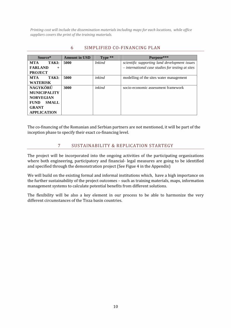
6 SIMPLIFIED CO-FINANCING PLAN Source* Amount in USD Type ** Purpose***
MTA TAKI: FARLAND + PROJECT
5000 Inkind scientific supporting land development issues – international case studies for testing at sites
MTA TAKI: WATERISK
5000 inkind modelling of the sites water management
NAGYKÖR Ő MUNICIPALITY NORVEGIAN FUND SMALL GRANT APPLICATION
3000 inkind socio-economic assessment framework
The co-financing of the Romanian and Serbian partners are not mentioned, it will be part of the inception phase to specify their exact co-financing level.
7 SUSTAINABILITY & REPLICATION STARTEGY The project will be incorporated into the ongoing activities of the participating organizations where both engineering, participatory and financial- legal measures are going to be identified and specified through the demonstration project (See Figue 4 in the Appendix) We will build on the existing formal and informal institutions which, have a high importance on the further sustainability of the project outcomes – such as training materials, maps, information management systems to calculate potential benefits from different solutions. The flexibility will be also a key element in our process to be able to harmonize the very different circumstances of the Tisza basin countries.

11
I. JUSTIFICATION
I.1 PROBLEM DEFINITION You cannot solve a problem from the same consciousness that created it.
You must learn to see the world anew. /A. Einstein/ The current water management and land use concept is raised in the modern river regulations from the 19th century. It had been developed in order to the modernization of the country, setting out from that modern approach that there are too much water on the Great Plain of Hungary and the area covered by water are unusable and worthless. In addition to Human was to bridle the Nature in the birth of modernisation. Human started to fight against nature; everything became industrialized, built on and for industry, driven by aspects of engineers’ and economists’ in a technical and financial approach only. Nowadays the city is the key economic driving factor and countryside only provide fiber and food for the society with more and more limited amount of water available. Meanwhile the highest flood risk occurs in the cities along the Tisza river (Koncsos, 2007). During the demonstration project we need to find out how water extremities could be handled in the Tisza catchments by proper local land development measures to increase water savings at local flood-basins to lower the risk of both rural and urbanized zones. Since the privatization in the beginning of the 1990s the Tisza river region suffers from over-fragmentation of parcels and unclear ownership (see Farland report, 2007; ICDR Tisza Analysis, 2007). The problem occurs mostly at rural areas suffering from high flood risk at former floodplains. The new flood risk reduction, regional revitalization projects in the frame of the New Vásárhelyi Plan (VTT) had large delays due to unsolved ownership problems, lack of capacities at implementation organizations on land management procedures. Land related issues are highly influenced by politics at all levels, so management related action programs have to struggle with these problem at each location, with cause huge delays, even financial losses (eg. Bodrogköz polder development, land expropriation)(TALK, 2005, Nováky, 2007). In the frame of a previous project (Farland, 2005-2007) the most important problems and case study specific solutions are collected on land development in different European countries. Many of these issues are only possible to address at national level, while others are specifically linked to local awareness raising and capacity building (see Table 1). Analysing problems in a proper manner - is one of the most important condition of finding good and effective solutions. Nowadays the biggest challenges for the society alongside the Tisza catchments are: � To ensure sustainable development and pressures on natural resources are decreased.
The protection of our environment is our primary and direct economic interest as well. � The natural and economic circumstances have changed and the concept on land use and
water management has not been changed along with it. � The weather conditions become unforeseeable and extreme (due to climate change). � After the river regulation the volume of water has either been to much or too small in the
catchments. Flood, inland waters, drought can emerge and just in one year. The current management system is expensive and does not provide solutions for the problems neither on short, nor on longer terms.
� We have to count with the high probability of drastic pollution running down in the river bed.
� The deep elevation areas drawn into cultivation after the river regulations cannot be efficiently cultivated on an intensive way utilizing the current cropping cultures. These areas are affected by secondary salinization, nature degradation, oxbows, former wetlands disappears rapidly.
12
� There is overproduction in developed countries – especially in the EU – of recent agricultural produces of the Tisza region and/but global food shortage overhangs as well at the same time. Demand for main crops are growing for industrial utilization, while in the life cycle analysis of these productions doesn’t take into account of the depletion of resources – such as water, soil, biodiversity.
� In the course of the Hungarian agricultural restructuring long term, modest profitability and increased employment rate in the regions/countryside should be increased, and the environmentally sensitive areas should be returned to semi natural, mosaic-like condition. In the EU the new trend is the recognition of the natural values. The natural bio-farming gained ground and wins expanding shares in the market. The new indicators of modernity are the decreased energy consumption is coupled with low environmental damage resulting in a product of the highest possible value.
� Ownership of the production assets (land, machinery) is crucial for local livelihood improvement and stopping present degradation of communities. Minorities should find their own occupations and community based; landscape production development oriented actions are needed in many Tisza –side municipalities.
� The political environment has changed, the open economies turned to be very fragile, profit gained in the region is pumped away.
� Proper developments harmonized with the Tisza basin circumstances (eg. In the field of alternative sewage treatment, rural development, SME support, navigation) do not take place.
� Welfare functions and recreation opportunities came to the front. The demand on tourism is inclining, where agro-tourism, eco-tourism are important factors. However key element is a well maintained, mosaic like, nature rich landscape with vital communities and local food, products along the Tisza river.
� One of the major priority of the European Union is the regional development, which covers the integrated expansion of the regions, including not only the agricultural operation in its specific meaning, but also the implementation of multi-sectoral projects supported by the entire community of the regions. The sustainable regional development should build on the multifunctional agriculture and landscapes with low threat of production (water; pollution, diseases, collapse of ecological supply processes).
If we accept the problems, we have to see that we have to change the structures that produces the problems (Gyulai, 2007). In this case the method of land and water management need to be changed. The change should take place at two levels:
– partly radically, inasmuch as the paradigm shift is required, – partly gradually, with no confrontation, by using our up-to-date knowledge and
technical abilities. The change can be supported by professional engineering skills, ecological based approaches and participative, awareness based processes.
I.2 BASELINE SITUATION Land development The earliest civilian land consolidation campaign in Hungary was finished by the time of the Second World War (in 1943). Reorganization of the parcels took place in 268 communities. After transition in 1990, following foreign examples with German and Dutch assistance, pilot projects (TAMA, PRIDE) were executed. In the Munich declaration (2002) it was stated that Central- and East-European countries should have taken land consolidation as an important tool of the rural development. FAO has also been supportive to land consolidation in the region with policy guidelines and help to

13
implement pilot projects. The experience showed the absence of legal background, insufficient financial resources, and lack of technical and organizational conditions for land consolidation, land development. The outcomes of the pilot programs however proved that procedure can be performed, and linked to rural development. Although it would have been possible to implement land consolidation within rural development programs (SAPARD, ARDOP) measure of land consolidation (e.g. re-parcelling) was not involved due to long process periods (5 to 10 years), and the insufficient legal, institutional, financial conditions, and lack of interest of political decision-makers and also land users. In the framework of land consolidation initiative Technical Assistance on Land Consolidation in Hungary (TALC, 2005) proposal for the Hungarian Land Consolidation Strategy was elaborated with the aim to establish land use and property structure which assists competitive agricultural production and rational, sustainable landscape management. It prioritized further tasks as the preparation and approval of legal background (law on land consolidation), necessary amendments (regulations for heritage, land lease, pre-emption), instructions of access to information, elaboration method of property exchange proportional to value. Considering organizational conditions creation of coordinating institution and improvement of the technical-technological, information technology, the establishment of adequate financial resources and other conditions (data bases, training) are missing. Recognizing the lack of sufficient resources available, the proposal suggests focus on implementation of projects in the field of VTT and environment protection, strengthening awareness for social acceptance and intensification land market in the frame of the NLFMO1 (Bíro, 2007). The course of implementation is preservation biodiversity and landscape protection with the development of land use. Protection and rehabilitation of natural ecosystems is supplemented by environment quality development in rural areas. The legal instrument for environmental land development is the 2nd National Environmental Program for 2003-2008, which forms attachment of Parliament Decision No. [132/2003. (XII.11.)]. The Tisza basin land ownership and utilization characteristics can be best illustrated by the satellite image of the area in the Upper Tisza region (see Figure 1. ). The figure illustrates drastic over-fragmentation of parcels, especially in case of lower quality (low golden crown value – old soil qualification system). The land registry data in the Bereg pilot lists 86 owners for an area of 17 ha suitable for forestation, designated as Natura 2000 site, where presently proper management and legal enforcement is almost impossible to maintain (see Figure 4 in Appendix). The pilot area in Nagykörű has similar ownership problems, while the ILD measures planned will take place at larger parcels (size of 300-500 ha) with limited No. of owners. The Hungarian floodplain management of riverside areas was introduced by the ethnography since the end of 60’s then used by the environmental sciences and recently was received by water sciences as well in the last few years. This process has been attached to the disappearance of original floodplains and the authentic land use by the 1 National Land Fund Management Organization

14
spreading of modern industrialised age then in ‘postmodern’ era to the revaluation of importance of ecological principals and rediscovery justified traditional methods. Hungarian floodplain management is been referred to as an integrated, nature-like, preindustrial land and water use system in the regions that belong to a river. So the attribute “ floodplain’ mainly shows the manner of approaching resources, not just its localisation. (In this sense one can make ‘non-floodplain’ management in a floodplain, as it is typical in the recent industrialised economy.) Since the most important feature of this traditional land use is that it is nature-like, in other words it do not want to change the natural regime of watercourse but it is adapting. Human do not create a new environment to serve his economy, as we did it in the modern-age regulation, but adjust his economy to the original/ natural environment, conditions (water movements, morphology, climate etc.). Hereby human can meet demands and sustain and even “develop” the nature in one system and activity. The expression “the region that belong to a river” means the flat, alluvial lands determined by the rivers with semi-continental climate and watercourse (irrespective of their actual distance from the river: in the Middle Tisza region we have Tisza floodplains in 50-60 kilometres from the Tisza bed eg. Hortobágy). “Integrated” meaning a multi-fold, multi-stage system: ensured the possible fruition of multiple link (also ensuring a frame to the whole farming and economy). Main utilisations are: � Fishing - blocking, sweeping, marsh-dwellering � Woods - hardwood, softwood, masting, grazing, other plants (like herbs). � Fruit - mainly pear, apple, plum, nut. Dried fruits, jams. � Gardening - i.e. water melon, tobacco (like in Nagykörü) � Animal husbandry - horses, cows, etc. � Field growing - at best subsistence farming � Reed, rush, hemp, etc. - household utensils. � Hunting, bird-catching, bee-keeping. � Transport - floatage (twin use), adaptation of “continental” methods. � Power generation - water-mills. � Household utilization
Water management in the Hungarian Tisza basin Besides the assumptions listed in the ICPDR Tisza River Basin Analysis 2007 we would like to highlight some local characteristics. The present water management practice is in general rather reactive than pro-active. While the VTT law emphasises the need of integrated approach, polders – such as Tiszaroff – are developed with mono-functional manner. The WFD implementation could lead to more adaptive river basin management with specific conditions, such as better institutional environment for data collection, processing and enforcing measures selected to save water in the Tisza basin. Especially in the Central part of the Great plain water saving related measures have high preference (aridity is very high, water deficiency is appr. 200 mm/year). Meanwhile large amount of excess water is drained (in the area of Nagykörű 61-90mm/year) (Jolánkai, 2005).

15
Low elevation areas suitable for permanent or episodic water storage are usually ‘water driven’, high clay content soils non suitable for main crop productions (so called ‘minute soil’ with very bad water management). The utilization of these areas (by land use change) for potential water storage could serve the landscape with extra water supply as well as lowering the risk in municipalities in case of flash flood. The present institutional setting and governance cannot ensure the stakeholder involvement at right levels in ILD related issues, especially the overlap between different organizations/agents responsibilities and the lack in specific capacities are important to note. The overall incorporation of ‘space for river concept’ in the daily management routines is highly recognized demand by the demonstration team. The landscape buffering capacity, including the role of ecosystems (especially forests and meadows) is an important element of landscape water cycles and important ecosystem services. In the Bereg landscape these services are listed, which create base for further assessment in the Demonstration project to support total economic valuation of ILD outputs. Table 5. Key services in ILD
Selected parameters – Ecosystem services assessment
A. Safety B Socio - economic aspects C. Environment and nature conservation (resource management)
1. Village safety 1. Landscape management and income potential Conditions for (extensive) farming
1. Soil management (structure, productivity)
2. Other infrastructures (roads, trains, channels)
2. Transparency (decisions, data, resources)
2. Water management (balance, quality)
3. Human life protection 3. Networks (socio-economic) 3. Protection of landscape heritage 4. Safety of production (arable land, orchards) 4. Tourist potential (including
secondary potentials) 4. Biodiversity, genetic diversity
5. Risk reduction effects on downstream and upstream 5. Game management 5. Water demand for ecology
/habitats
6. Water storage capacity 6. Biomass production 6. Climate change effects – carbon sequestration, adaptation and mitigation
Community involvement and participatory planning In the filed of community involvement several initiatives provide good basis to understand the needs for effective participative planning and implementations. Meanwhile in the Tisza basin the socio-economic problems lead to very high degradation of community life, which provided an important base for flood defence mobilization and joined actions (such as floodplain forest management, fishing, maintenance of channels, fok’s). (Vári et al, 2006)

16
Local municipalities suffer from depth and over centralization of resources and highly rely on external project sources with high risk. Development ideas (to increase employment level) arrive from external investors who do not harmonize their goals with the local circumstances and abilities and sometimes risk the long term use of resources. Key concepts such as participation, stakeholder involvement, subsidiaritiy are very important but many times empty phrases and taking the WFD preparation as an example do not reach real stakeholders – neither the weak ones who will never visit a public hearing nor the real ‘big guys’ – the large land owners and investors (in case of the Tisza basin many of these actors are only land speculators). That’s why new approaches are needed to involve all partners at local level, build consensus on long term goals and harmonize it with the short term demands. ILD can be one way of utilizing these capacities and provide examples to disseminate. There are objective barriers as well, since these actors, important stakeholder groups do not speak the same language and have very different understanding about the problems. Without harmonization of the thesaurus between city and rural thinkers, water, nature, infrastructure and land developers the communication and action is difficult at local /landscape level. The problem is even larger if we try to build cross border consensus or vertical effective communication. Conceptual models developed in the last years for the Tisza river could play an important role to explain key drivers, processes for these actors and to perform more successful implementation of the ILD, (see Figure 2)
I.3 STRATEGY The project follows the methodology described in the Millennium Assessment (UN, 2005) as an overall concept. Besides key policies such as WFD, Natura 2000, CAP (and in it the Leader Program) and Climate Change Policy provide important frameworks as well. The principles of the SZÖVET (ALT) are followed of which the 3 most important ones are: The Principle of Relying on Local, Internal Resources Less dependence on external resources makes livelihoods in a region safer. When developing the strategy, we considered the region as if it might lose its access to external resources (e.g. subsidies, applications, capital investments) at any time. Of course, all local developments should use external resources if these resources are available. Nevertheless, we should be aware that all resources derived from outside the region are uncertain; they exist today but may disappear tomorrow. For this reason, local people should create social, economic and land-use systems which are co-operative in nature and dependable in the long run. The Principle of Adaptation to the River Adaptation to the risk of natural disasters is especially relevant in the Bereg. In planning a long term strategy, we admit that heightening the dams and continuing using traditional flood protection methods is not a safe option over the longer term. Most of the Bereg area is under the flood level of the river Tisza. Land use and the related economic structure are viable if they are adapted to natural circumstances.

17
Controlled water supply from the river and related flood plain management therefore serve such an adaptation. Such a land management system remains viable and provides a livelihood and safety for the local population - even if the dam system can not be sustained for lack of financial resources or as a result of a natural disaster. The Principle of Passing over the Burden According to research observations, when intervention in a system occurs and some tasks of the system are assisted or taken over by external actors, the system passes these tasks fully over to these external actors. For example, we consider the nursing of elderly people and of small children a state or community task, although in previous times it was the task of the family. The most severe consequence of this passing over of responsibility is the weakening of ‘social fabric’; weakening of social co-operation. In such a transformation process important elements of a healthy society disappear (such as the system of mutual favours, care, the feeling of self-worth and importance or security). We would like to educate participants about the advantages of local society taking back several tasks, beyond the lower level involvement of external resources. Specified criteria for the ILD can be clustered into 3 cathegories – environemtnal, social and economic. The list will be further specified and elaborated during the project, it is an example of the ideas developed during project formulation phase (see Table 6).
Table 6. Main clusters of criteria and methods used in ILD Cluster Criteria Method of assessment
Environmental Water retention capacity of landscape (in flood risk, in normal operation)
Landscape-river connectivity, water steering structures
Soil conditions and agricultural productivity
Ecological value of habitats (Natura 2000) revitalisation capacity and water dependence (water stress-index) S-M
Duration and depth of water cover
Field work, monitoring
GIS assessments, DTM
Landscape development history assessment (from 18th century)
Small scale ecological surveys
Social Reduce risk and system vulnerability (maximise regional, community, individual/private protection)
Empowered land utilisation , knowledge on floodplain management, ILD
Inhibit not sustainable development strategies
Joined responsibility and ownership, improved regional network and lobby power
Equity, transparency of system benefits
Social discussion, forums
Trainings
Survey on values, expectations, knowledge
Elaboration of alternatives of models, data and information gained from assessments
Networking with other pilots
Economic Lower implementation cost of constructions M
Lower long term maintenance cost L
Lower stock at risk (e.g. changing locations of buildings, farms, infrastructures ) M
Maximised landscape production (re-parcelling, land use change, new products, services) S – M- L
Realised environmental service cost (subsidies, payments, support) S-M
CBA of technical measures
Land use structure assessment, Land Consolidation and Land Development planning
Product cycle assessment of present and alternative LU
CBA for services of LU

18
I.4 PROJECT AREA “An important European resources” is the head message of the chapter introduces Tisza River basin in ICPDR’s analysis 2007. These works demonstrate well the most important characteristics of the land belongs to the Tisza. Here we just stress few point as key factors to understand basics and importancy of this project, that proposes developing a sustainable, effective cooperation between human and nature through land use and water management. Half of the territory of Hungary belongs to the Tisza catchments. Even that, quarter of the country which has chronic rain deficit (aridity index: 1,5), is the heart of he Tisza basin nevertheless surplus water of floods is wasted when it simply drains away instead of supplying this deficit. At the same time (and process) we have high risks (and costs) of different damages of flood, inland water and drought. The landscape is not simply a flat plain. Different elevations have different functions: beds and floodplains are for transportation and storage; non-flooded levels are for the settlements. This pattern (would) offers a natural infrastructure for water steering. Besides Tisza catchments has very different sub-basins from which we have selected 3 as pilot sites from the source branches to the Duna bed. ILD project wants to connect these pilots - as the Tisza river (and affinity of problems) connects them. The project is implemented at 3 locations (see Figure 6):
• in Nagykörű and its sub - basin • in Zenta and its sub-basin • and in Székelyudvarhely and its upper catchments.
The Tisza basin and the 3 pilot sites in ILD demonstration project

19
Nagykörű area, as the central area of project had more complete review above parts where phenomena and processes were introduced, other important characteristics of selected pilot areas are listed here from upstream to downstream: Area centred round Székelyudvarhely-Odorhei
- mountainous area, with the highest point of 1800 metres above sea level, with the centre of Udvarhely-basin
- west slopes faces the west winds, with massive annual, in case rapid, rainfall (conf. huge flood damages along Nyikó river in the summer of 2006)
- with lots of forest, meadow, and some arable land around villages on the alluvium, mosaic pattern
- more traditional land use and social forms staying alive recently alterred by modernization
- typical high section of the catchment Area centred round Nagykörű
- perfectly flat plain with the typical elevations of the Great Plain: former river beds, tills, high banks, difference less then 10 metres
- closed floodplain sub-basins and sub-catchments water could arrive from the Tisza and would retained to the Tisza – in the help of detected fok/’notch’-system
- 90 % arable land, fully drained potential floodplains with potential wetlands, forested active floodplain full of invasive species
- canalized but not dammed riverbed with natural(-like) processes (either hydrological or morphological)
- industrialized agriculture and society, opened economy - typical middle section of the catchments
Area centred round Zenta-Senta - more dynamic landscape: loess-plateau, terraces, floodplain – difference up to 30
metres - same agriculture, different country (circumstances) - degradated natural conditions, biodiversity, resources - reach /headwater section of the river (Óbecse-Becej dam from 1977) - overused groundwater, sinking ground-water table on plateau and increasing
water table on floodplain and under the city - effective industrial usage, oil tank-farm, massive pollutions from time to time - great channel from Duna (DTCh), wide-spread irrigation - typical low section of the catchments.
The location of Nagykörű is taken as an example to illustrate the imbedded approach highlighted in the summary as well. The work and conceptualization is done at the flood basin and its Nagykörű sub-basin (see Figure 3). The measures for improved land and water management will concentrate on parcels in the areas, while conclusions and further affect will be defined at the Jászkisér Flood basin and for Central Tisza level.

20
I.5 STAKEHOLDER ANALYSIS The project main action filed is the local level (municipality and its surrounding sub-basin) where concrete implementation will support the identification of good measures and tools (Nagykörű). That’s why the most important SH assessment is done at HU local level. Besides the other local sites supports the process – and implementation will depend on the extra support gained through the processes. The most important SHs are listed at these locations and additional ones will be elaborated in the inception phase with special focus on further funding opportunities. The national and international level SHs are also taken into account (but not detailed in the table) since in the risk assumptions (see II.7) the role of the political/strategic and organizational support has been identified as a key factor. (e.g. potential support of ICPDR and Tisza Group to involve other Tisza basin countries in the legal and governance assessment; political will to deal with land issues to lower the risk; attitude of water management actors to have long term solutions with low maintenance cost vs. keep the role in defence development and operation.) STAKEHOLDER IDENTIFICATION AND ASSESSMENT
Stakeholder and basic characteristics
Interests and how affected by the
problem(s)
Capacity and motivation to bring
about change
Possible actions to address stakeholder
interests
Nagykörő municipality High interest
Long history to support alternative solutions
High flood risk in the neighborhood
Administration support
Leadership and consensus building capacity
Good connection with state authorities
Utilization of local networks
Administrative support with documentation for land registry
Participative data collection – involvement of school
Awareness raising actions – community planning
Large Farmers and farmer associations (such as First Floodplain TÉSZ) in Nagykörő (above 50 ha)
High interest (see support letters)
At same location in the same year stagnating water, drought could appear. During flooding the upwelling damage is high (eg. in 2006)
The farmers take place in the process, ready to change the parcels.
The motivation is to lower the risk (see I.3)
Risk calculation on longer term with present landscape structures.
Taking good examples from international cases (study tour).
Small farmers in Nagykörő (under 50 ha)
Medium interest, but important from system solution point of view.
Effected by environmental threats, too.
These farmers are more difficult to change since potentially their total area could be affected and suggested for change – this creates more complex decision field for them.
Local land bank could assist the involvement of small farmers to support voluntary land exchange or land utilization change. payment of administrative cost and solve ownership problems are also an effective tool to

21
Stakeholder and basic characteristics
Interests and how affected by the
problem(s)
Capacity and motivation to bring
about change
Possible actions to address stakeholder
interests convince these actors.
Minorities (Gypsy population)
low interest
unemployed, low educated people with very bad circumstances
to take part in small water infrastructure development
support the landscape reconstruction work
Involvement in field work
build coalition with local communities
Water Board - Jászkisér High interest
Key players in territorial water management.
Roles are not clear in future water management.
Data and planning capacity as well as expertise on water infrastructures design and management.
High involvement from the beginning in the project.
Further project desing with all SHs involved (including national and regional level water administration)
Civic society, Nagykörő Low interest
Degradation of income opportunities and ecosystem services has high impact on life quality.
Important in social mobilization (festivals, community actions)
Mobilization of small farmers, semi- substitutive farmers
Central Tisza Water and Environmental Directorate
Middle interest
Key players in the Tisza river section water management including flood and irrigation.
Partners in several large KEOP programs. Responsible for further project development.
Data management and planning capacity.
Link to the VTT and its implementation seeks good practices in integrated solutions.
Involvement in the process from the project preparation.
Utilize the knowledge and opinion on water management and build consensus on tools.
Central Tisza Water, Environmental and Nature Authority
Middle interest.
Key players in authorization of VTT actions (polders, floodplain measures).
By understanding the need of integrated measures can be an important supporter of ILD in concrete projects.
Conceptualization involvement.
Economic assessment (TEV) to proof the efficiency of the measures.
Pilot results incorporated into institutional system.
Bereg Farmers with unclear ownerships (undivided joined property)
High interest
LU at area affected by flood risk cannot be changed to forest due to present ownership
Local farmers are willing to take part in ILD – local forestry integrator will support farmers participation
Financial support of the process
Elaboration of benefits after ILD
Székelyudvarhely Municipality
Low interest
LU is an important factor to tackle flash flood risk, degradation
Administrative support.
New types of cooperation and actions.
Participatory planning coordination
Pilot results dissemination

22
Stakeholder and basic characteristics
Interests and how affected by the
problem(s)
Capacity and motivation to bring
about change
Possible actions to address stakeholder
interests of natural resources.
Zenta civic organizations Low interest
Degradation of income opportunities and ecosystem services has high impact on life quality.
Important in social mobilization (festivals, community actions)
Mobilization of small farmers, semi- substitutive farmers
II. PROJECT DESIGN The project has been co-desinged by SZÖVET and MTA TAKI experts, involving the partners and building on the experiences of the previous UNDP-GEF project key lessons.
II.1 PROJECT OBJECTIVE The project main objective is to develop integrated land and water management protocol through case studies to support efficient water and land management at areas with high risk (drought, stagnating water, flood, biodiversity loss) along the Tisza river and its specific locations; based on the floodplain socio-economic concept (Kajner - Molnár – Flachner, 2003). The main building blocks of the concept are:
Controlled water outflow & backflow to main river channel in line with criteria for: • Flood risk management • Floodplain retention • Ecological thresholds
�
Water steering in floodplain & rehabilitation • Secondary notch-system for irrigation • Revitalisation of old creeks, wetlands • Economic utilisation (e.g. fishponds) • Harmonized water distribution among actors
� � Rural development, land use management • Diverse land use, fit to the micro-elevations and
natural conditions • Agrotechnology (small/medium size, permaculture) • Payment of ecosystem services (e.g. flood
protection, agri-environmental payments, implementation Natura2000, Water Framework Directive)
• Diversification of economy, additional income sources (e.g. rural tourism, biomass production)
�
Governance and Institutional support • Education, training, information dissemination • Increased public participation, lobby,
representation of local and regional interests • Monitoring expert system, GIS-based monitoring
and operational water steering support • Maintenance of water steering infrastructure,
coordination of water related activities (flood protection, irrigation, drainage, ecological water supply, water storage)
Floodplain management concept (Kajner – Molnár - Flachner, 2003)
In the demonstration project these key building blocks will be applied as a framework to elaborate, define and implement concrete action at parcel and community level to increase the water retention capacity and lower risk for production, ecosystems and water system. The objective can be formulated based on the most important present processes (Sendzimir et al, 2005). Its key elements are:
a.) sufficient amount of water in the landscape; b.) proper landscape management ensuring the key natural processes – soil formation, biodiversity maintenance; pollution elimination and high productivity;

23
c.) community well-being which depends on many factors, eg. Culture, supporting policy, ownership, technologies and land use (see Figure 2 in appendix).
The project key objectives and planned outputs are: 1. To elaborate the legal situation related to ILD and provide useful recommendation on base
of five Tisza country survey. � Define the assessment framework � Test the framework on the HU situation and provide a sample document for the other partners � Develop detailed questionnaire for the assessment of the partner countries and do pre-testing � Implement the first round of the survey, discuss the difficulties, identify further needs for involvement � At a workshop compare the countries legal framework to apply ILD and define recommendations � Circulate draft report among the partners and supervision bodies. � Finalize recommendations.
2. To implement the ILD at one pilot, to develop further pilots at our partners � To summarise foundational works on LUC in pilot sites (data collection and
assessment, complementing data, maps and charts on the key indicators) � To complete land use change in selected pilot sites (arranging administration,
setting parcells, improving conditions for pasturage – eg. removing un-proper vegetation)
� To adapt selected water infrastructures (sluice operation, canals) to serve improved water management at sites
� To change the land use on selected sites, adapting vegetation to elevation (arable land to wetland at locations of former riverbeds)
� To enter ILD protocol into practice at other pilots (further project development) 3. To disseminate the experience and the lessons of the implementation: � to establish better cooperation with our partners in Serbia and in Romania,
understandings of different circumstances and prepare further projects; � develop training materials based on the implementation of the demonstration
project, which will be available for all countries in the Tisza basin;

24
� to support bottom up land development processes train local ‘ILD mediators’ (training of trainers), based on the applications at the pilot sites in the Tisza region.
II.2 PROJECT OUTPUTS AND ACTIVITIES The project outputs follow the key objectives set in section II.1. In the followings we are detailing these outputs and the activites planned. Time schedule of the activities are indicated in II.4. Outcome 1: ILD Protocol based on Tisza catchments countries legislation and governance, decision making framework The objective is reached by implementing the following actions: Activity 1.1 Legal overview of the 3 participating countries, general comparison for all Tisza countries by questionnaire. The next steps are planned: � Define the assessment framework - with the support of the Károly Róbert Univiersity Faculty of Law and the involvement of high level LD and LC experts from the Ministry of Agriculture and Regional Development and the National Collective Property Agency � Test the assessment framework on the HU situation and provide a sample document for the other partners – based on the results of the TALK and the FARLAND project a harmonized and suitable framework for assessment is going to be developed which helps to implement the survey by non-legal experts. � Develop detailed questionnaire for the assessment of the partner countries and do pre-testing – in Hungary and at partner countries
Activity 1.2 Analysis of legal constrains through the implementation of the pilot sites � Implement the first round of the survey, discuss the difficulties, identify further needs for involvement – utilization of demonstration project network and the ICDPR expert network is suggested. � At a workshop the countries legal framework to apply ILD will be compared and participants will define general and country specific recommendations – with involvement of land development expert (idea of involving FAO LD consultant)
Activity 1.3 Recommendation on good governance for sub-catchments, small landscapes in light of the proposed changes for water retention areas in the Tisza basin � Based on the result of the legal assessment as well as the results of the pilot implementation and the series of workshops recommendations on good governance are formulated. � Draft report is going to be circulated, commented among the partners and supervision bodies. � By finalizing recommendations a short policy paper and a longer report will be prepared.

25
Most important tools applied: legal review and assessment, interviews, reporting, workshops Output 2: ILD at selected sites implemented Activity 2.1 Development of data and information system locally to support the ILD process, including economic data on local business and ecological services � Geographical data collection and integrate into a GIS system, with special
attention on LU, elevation and ecosystems (level of protection). Data on CC affects in the region.
� Socio-economic data collection on land utilization trends and related incomes, expectations of farmers (short survey) and risks of production.
� GIS system for the sites at all pilots are going to be established with teh support of Partner 1.
Activity 2.2 Elaboration of different LUC alternatives � Apply participative planning as a key processes on discussing Land development
alternatives for the selected sites – based on the prepared GIS system, calculated water balance and water system management options.
� Economic assessment and comparison of the alternatives based on the TEV and ecosystem service approach
� Summarizing the results in a table along the selected indicators and build consensus on the alternatives and the LD measures required.
Activity 2.3 Water management measures planned and verified by water-board (WB) and water directorate (WD) at selected sub-basins/sites Implemented ILD at selected � Selection of the site for implementation involving affected farmers, water board
and water directorate as well as relevant municipality � At Nagykörű start implementation - application of LD measures selected. � At other partners start detailed feasibility planning of future implementation (or
start small scale implementations) � Each step evaluation of measures effectiveness and procedures � Summarizing the results – evaluation of the process and the progress
Most important tools applied: field work, GIS development, land measurements, engineering plans, participatory planning and landscape visioning, workshops, reporting, Output 3: Dissemination of ILD concept and the results in the Tisza basin and at UNDP- ICPDR level Activity 3.1. Trainings at location of implementation and at the partners locations � Each partner will host 1 workshop, SZÖVET will host 2 workshops and site 2
trainings to share the knowledge gained and harmonize the conceptual framework
� Training of trainers in the 3rd part of the demonstration project will take place to ensure the proper dissemination of methods applied and developed for ILD

26
Activity 3.2. ILD toolkit and CD development � Based on the performed activites, study tours and international literature review
the key modules of effective and efficient ILD is summarized � The sub-team of partners set up the frame of the toolkit and do editing of the
collected results and documents � Draft version of toolkit is discussed at all-partner workshops and at the training
of trainers � Finalization of toolkit and CD with effective serach fundtion prepared.
Activity 3.3 Final Stakeholder Workshop to evaluate the process and to approve the recommendations Most important type of activities: workshops, assessment of results, reporting and editing of reports, publishing works
II.3 IMPLEMENTATION ARRANGEMENTS The project implementation has few pre-defined principles:
• efficient communication – with the project partners and the regional national international interest groups
• flexibility – in procedures and project implementation. Each project meeting the implementation risks will be discussed and if necessary modification decided.
• Multifunctional approach – in integrated project the key element is the capacity to bring very different objectives, tools together at one location (eg. Combination of CAP, Natura 2000, WFD, Kyoto).
• knowledge transfer – the trainings and the process of implementation are excellent opportunities to bridge science and practice as well providing evidences for the local level SHs on CC and risk related issues. Besides new technologies, advisory services could be linked as well for the benefit of the partners.
The implementation is coordinated by the SZÖVET and all partners are delegating one responsible person. E-mail mail-list going to provide access to all relevant information, besides at the Élőtisza website (www.elotisza.hu) a project subfolder for materials to comment and results to disseminate is going to support the process. The filed works and training material development arre supported by the SZÖVET expert team, in case of legal issues support from the Nagykörű Municipality and the Károly Róbert University Law Faculty Doctoral School is going to be provided. Each week an internal meeting will take place in the SZÖVET team. Every 3 month all-partner workshops are going to be organized where trainings, practical filed works and study tours are combined to save time, travel cost and organizational efforts. Based on the preliminary negotiations the suggestion from our team is the direct payment of ICDPR to the partners based on the pre-defined share in the project to avoid the extra taxation and VAT cost which would occur in case of HU partner payment.

27
II.3.A PROJECT TEAM The lead organization of the demonstration project: SZÖVET - The Alliance for the Living Tisza Association (ALT).
Project coordinator: Kajner, Péter, economist Project expert, local coordinator: Balogh, Péter, geographer, Zoltán Füzessy, marketing and HR manager, Fehér Lóránt, legal expert Project expert in Bereg: Asztalos, István forester Project assistant: Matúz, Krisztina
Partner 1: MTA TAKI- RISSAC – Hungarian Academy of Sciences, Research Institute for Soil Science and Agro-chemistry
Project expert: Flachner, Zsuzsanna, environmental manager GIS expert: Bakacsi, Zsófia, geologist and Pásztor, László GIS specialist Land consolidation expert involved to support the process: Biro Szabolcs, AKII; Sebestyén Róbert, National Property Agency
Partner 2: AGORA – Project expert (focal countact point): Péter Pál Project expert: Ambrus László
Partner 3: Zenta Municipality Project expert: Kosicki András, international relations MR Hovány Lajos Phd. civil engineer, University of Novi Sad http://www.gf.su.ac.yu/index_e.html He is mentioned as the most informed author in water management in Vajdaság /Vojvodina especial in historical aspects. He have 123 publications, including 5 books, mainly in the topic of the past of water management in NE-Bácska (Zenta region). He will be involved in the project as a local expert in water issues.
II.3.B PROJECT SUPERVISORY BODIES The project supervision is done at two levels:
• The SZÖVET has its own advisory council (AC), which consist of 30 internationally well-known experts and key stakeholders (pl. Andrásfalvy Bertalan). The AC have meetings each half a year, where the ongoing activities and results are elaborated and commented.
28
The Council acts as a dissemination forum as well, several national organizations (eg. WWF Hungary) is involved and takes the key messages further.
• The Tisza expert group will provide supervision of the activities as well, the planned meetings and the option to take part at our workshops (invitation will be sent) will provide opportunity to comment the process, provide advices and critical remarks as well. The early warning on potential risks and barriers are very important since the duration of the demonstration project is very short.
II.3.C ROLES AND RESPONSIBILITIES OF PARTNERS AND STAKEHOLDERS
The project has a very important horizontal cooperation, partners at pilot sites and pilots are strongly depend on each other. The SZÖVET is responsible for overall coordination and reporting. Beside the involvement of local and regional SHs and link the project to national and Tisza level is a key element of the activity and is in line of the expected lobby activities of the organization. MTA TAKI is supporting the process with scientific help (data, agricultural suitability maps, GIS expertise). Besides substantial help on reporting and administration are going to be provided too. (bridging science and practice). AGORA is responsible to hold one workshop at their location. Besides supporting data collection, perform data assessment and following the methodology in ILD will be their task as well. Based on the preliminary discussions there is a high chance to be able to implement a small project from the resources planned. Zenta Municipality will be a very important comparison base on the roles and opportunities for implementation of ILD by a governing agency. Since the Municipality is a conglomerate of several sub-administration units, one will be selected in an inception phase for project development and detailed field work. The roles and responsibilities will be further elaborated in the inception phase.
II.4 WORKPLAN As activities and tools applied are detailed in II.2, the work plan is not explained in details. The key milestones are the followings:
- - Inception Workshop and Report 1 - - Project team established 2 - - Coordination meetings of partners 3 - - Establishment and meetings of the Project Supervisory Body (Steering
Committee) 4 - - Quarterly Progress Reports and Final Report 5 - - Mid-term and Final Review 6 - - Financial Audit 7 - - Legal review 8 - - Report on participatory evaluation of ILD options 9 - - Training of trainers -1. module: data collection assessment framework, legal
frames 10

29
- - Training of trainers – 2. module: ILD in practice – from planning to implementation and assessment 11
- - Data and information system description 12 - - ILD implementation report at selected sites 13 - - Tool-kit and reccomendations 14
Table 7. Workplan
Month Outputs and Activities 1 2 3 4 5 6 7 8 9 10 11 12 13 14 15 16 17 18 Output 1 Activity 1.1 legal overview in Tisza basin countries ► ► ► ► ►
Activity 1.2 Assessment ► ► ► 8 Activity 1.3 governance protocol development ► ► ► ► ► 14 Output 2 Activity 2.1 data and information collection, socio-economic assessment
► ► ► ► ► ► ► ► ► 12
Activity 2.2 participatory evaluation of alternatives
► ► ► ► 9
Activity 2.3 ILD implementation
► ► ► ► ► ► ► ► ► ► ► ► 13
Output 3 Activity 3.1. trainings of trainers 10 11
Activity 3.2. ILD toolkit +CD development ► ► ► ► 14
Activity 3.3 Final workshop 14 Project management, monitoring and reporting * Inception Period ► ► 1 Establishment of project team ► 2 Project management and coordination ► ► ► ► ► 3 ► ► 3 ► ► 3 ► ► 3 ► ► 3 Project supervision ► ► 4 ► ► ► ► ► 4 ► ► ► ► ► ► ► ► 4 Reporting 5 5 5 5 5 5 External implementation review ** 6 6 Financial Audit 7
Key Ongoing activity ► * Minimum requirements indicated Milestones x ** Costs to be covered from UNDP support
Inception Workshop and Report 1 ►
Project team established 2

30
Coordination meetings of partners 3
Establishment and meetings of the Project Supervisory Body (Steering Committee)
4
Quarterly Progress Reports and Final Report 5
Mid-term and Final Review 6 Financial Audit 7 Legal review 8 report on participatory
evaluation 9 training of trainers -1. 10 training of trainers - 2 11 Data and information
system description 12
ILD implementation report 13
Tool kit and reccomendations 14

31
II.5 BUDGET AND CO-FINACING PLAN
Budget – see budget in the summary The budget reflects the discussion with the project partners and the ICPDR representative, UNDP advisor. 10.000 USD (netto) was taken into account per Romanian and Serbian partner organization, which cover the cost of their activities performed and participation costs (travel, accommodation food) at workshops. The Hungarian public accountancy law requires extra taxation after each person payment on food, accommodation, that’s why the DSA system need to be applied to avoid these extra cost. In the inception phase the internal regulation on the DSA have to be specified and approved by the donor agency. The implementation of the ILD at parcel level requires several LD costs elaborated by the Ministry for Agriculture and Rural Development TALK project (2004-2005), which has been taken into account in the budget (30.000 Ft /ha). The project will further elaborate the general number and provide more specific cost calculation. The project coordinator at SZÖVET is employed for the project duration (6 our employment) – further personal employees at the different partner organizations accounted by the organizations payment sheets cover costs. Activity 3.3.: Final workshop: includes 5-6 representatives from each partners and supporters and the last session of training of trainers is incorporated. WSs are organized at different partners – the travel distance to Ro site is 850 km from Nagykörű and ~1000 km from Serbia. Printing cost will include the dissemination materials including series of maps for each locations, while office suppliers covers the print of the training materials. The project will built on the experience gained in other river basins land development activities to increase floodplain areas and lower the risk. The 5 selected local partners trip to Germany and Poland will be a least cost alternative to visit the sites, collect good governance alternatives and discuss them with the local activist performing those measures in the Rhine and Elbe river. The trip will be part of the project management cost and co-financed by the participants. SZÖVET (Lead partner) co-financing is covered by the activities performed in the WATERISK national project, where the organisation is responsible for dissemination activities and local data collection. Besides the other parallel projects – such as the market development for floodplain products – are creating more positive decision-making environment for land use changes (see details at II.8). The MTA TAKI (Partner 1) co-financing is generated from 2 sources – the FARALND project pilot region descriptions and survey samples which can be utilized in the project. Besides the WATERISK project starting in 2009 January will provide data, personal resources of GIS activities and participating at meetings. The Romanian and the Serbian partners are supporting the data collection and legal review as inkind contribution.

32
The Nagykörű municipality, who is not a partner but supports the process, have a project under approval for local economic development. The project can assist the integration of ILD into local economic development, livelihood improvement. CO-FINANCING PLAN
lead partner
1 2 3
Output 1 0
Activity 1.1 legal overview in Tisza basin countries
personnal (PhD studnet extra work)legal experts at organizations
1000 2000
3000Activity 1.2 Assessment 1000 1000
Activity 1.3 governance protocol development
personnal (PhD studnet extra work)legal experts at organizations
1000 2000
3000Subtotal 1 2000 5000 0 0 7000Output 2 0
Activity 2.1 data and information collection, socio-economic assessment
data collection/primer datamodelling
1000 5000 1000 1000
8000Activity 2.2 participatory evaluation of alternatives 0Activity 2.3 ILD implementation 0Subtotal 2 1000 5000 1000 1000 8000Output 3 0Activity 3.1. trainings of trainers 0Activity 3.2. ILD toolkit +CD development 0Activity 3.3 Final workshop 0Subtotal 3 0 0 0 0 0Project management, monitoring and reporting 0Project management, monitoring and reporting 0inception period 0WS /5-6 persons at 2 days/ 0Subtotal PM 0 0 0 0 0TOTAL 3000 10000 1000 1000 15000
Outputs and activities Type of costs * Partner / Stakeholder
TOTAL

33
II.6 REPORTING, MONITORING AND INDICATORS Reporting activity is based on the ICDPR and UNDP advices. Two types of document is going to be prepared:
- progress report every 3 months summarizing the main activities and expenditures - project reports as listed in the Work plan (II.4).
After the inception phase an inception report is prepared based on the project document. The monitoring and indicators are elaborated on output base (following the information summarised in the logical framework matrix).
Indicators Monitoring ILD Protocol based on Tisza catchments countries legislation and governance
Overview of legal documents in the beginning of the project based on a common design – topics such as land registry, land development, integrated land development, landscape development and river basin management, water and land governance at local, regional and catchments levels will be covered. The process will be repeated in the end of the project. Report is produced where the modifications, recommendations are listed. (qualitative)
At selected pilots sites ILD implemented
The detailed step by step process designed for ILD in the early phase of the project will give the frame of the process and progress monitoring if the implementation, following the set milestones (feasibility study; detailed participatory plan for several sites; implementation). Report on the qualitative information is going to be prepared. Besides quantitative data is collected on: - implementation of ILD (ha) - No. of SHs involved - risk reduction (Ft) - further plots ready to implement ILD (ha) - change in land registry (No) – land use category, ownership, parcel splits
Water management measures to support water retention capacity development and lowering risk at low and medium elevations – plan and implementation for Nagykörű flood - basin
Maps and GIS Geodetical measurement Feasibility studies for several sites Plan for implementation and execution: - modified water infrastructure (channels, sluices, micro channels at parcels, etc.) (km, site No.) - amount of potential retained water (m3)
II.7 RISK AND MANAGEMENT RESPONSE
The logical framework matrix (see end of the document) lists several risks and assumptions, from which we have clustered the most important ones – the evident ones, such as data harmonization problem are not listed here.
# Description Category Impact & Probability
Countermeasures / Mngt. response
1 Not enough support Organizational If the support from all Tisza Strong support from

34
# Description Category Impact & Probability
Countermeasures / Mngt. response
from non- participating countries, regions, authorities.
(Political) countries will be not sufficient the outreach of the ILD will be not having strong impact on risk reduction, biodiversity protection and livelihood of local people. P=1
ICDPR and its counterparts. Intensive communication of ideas and results. Total economic assessment of the pilot measures.
2 Protocol developed will be not officially approved by the end of the project due to long term bureaucracy. This can be due to low political awareness, interest conflict, low cross-sectoral cooperation.
Organizational/ Regulatory (Political)
Based on the local consensus implementation could have delays or despite of the successful local implementation the spread of the ILD method could be delayed or even blocked, or partially implemented (not following integrated approach – such as VTT. P = 3
Very strong communication on cause-effect relations, expected benefits and develop success stories with economic evidences. From the beginning active involvement of water management experts at different levels, organization types.
3 Insufficient cooperation among farmers for redefining the water management at the basin.
Organizational
Since the pilot selection is based on voluntaries, this risk can have only impact on the amount of territories involved in the ILD. P =1
Flexible approach will be followed – starting with several options in the preparatory process not pushing the partners and provide enough time to learn and experience from each other. Participatory and voluntary approach is a key for the success.
4 High cost of measures – need to search for additional funding.
financial Implementation could be slower, the amount of territory or water infrastructure measure must be reduced. P = 2
Strong cooperation with Water directorate and Water board needed as well as collaboration with business partners. Additional project proposals could be developed during the demonstration period for further funding.
5 Harmonization of text – to fit for all Tisza basin countries
Legal (political)
Country specific regulation could be developed only – no sufficient overall strategy for the Tisza basin land development. P = 3
Strong support from ICPDR from the beginning of the demonstration project to understand the need for integrated land development in the whole catchments. Only transboundary approach could lead to successful WFD implementation.

35
II.8 COORDINATION WITH RELATED INITIATIVES The project is strongly linked to WFD implementation and VTT further planning. The links are evident and not detailed here. The related initiatives have been collected during the project preparation, by visiting the partners regions, discussing it and overview of the documents provided by partners. The flowing list concentrates only on the key programmes. SZÖVET: The project on market and local product development along the Tisza has started in 2008 and will provide great help to evaluate the business opportunities. It is linked to a EU project with deals with eco-marketing and eco product development (lead: ELTE, Védegylet and Gödöllő is taking part). The WATERISK project starts in 2009, where the objective to have risk assessment for the full Tisza basin in the light of different future scenarios. The SZÖVET has a dissemination role, which can be combined with the objectives of the demonstration project. Nagykörű Municipality: The municipality has applied for a Norwegian Fund Large Scale project to improve the local food processing capacity in the micro region. The application has been supported and it is foreseen to get support. The project could provide very useful business evaluation information and knowledge to our project. First Floodplain TÉSZ: The organization has been established by the LIFE project co-implemented by WWF Hungary. It has a key role in meadow management and can support the LU change at the selected areas. MTA TAKI: The WATERISK project starts in 2009, where the objective to have risk assessment for the full Tisza basin in the light of different future scenarios. The MTA TAKI has substantial role in the data management at Tisza basin level, which could provide useful insights for the generalization of the pilot results. AGORA:
- summer voluntary revitalization campaigns - landscape revitalization works - spring catalogue and mapping, implementing revitalization
Zenta – Senta Municipality: - Tisza floodplain revitalization - Ecological farming promotion - Landscape development - Local heritage management

36
III. SUSTAINABILITY AND REPLICATION STRATEGY
Key buidling blocks in intergtaed resource management
The project will be incorporated into the ongoing activities of the participating organizations where both engineering, participatory and financial- legal measures are going to be identified and specified through the demonstration project. We will build on the existing formal and informal institutions which, have a high importance on the further sustainability of the project outcomes – such as training materials, maps, information management systems to calculate potential benefits from different solutions. The flexibility will be also a key element in our process to be able to harmonize the very different circumstances of the Tisza basin countries.
REPLICATION STRATGY The project main aim to incorporate the results into several processes, such as:
• Local planning and management process • WFD imprlemtantion in the sub basins • VTT implementation in Hungary • Other water saving measures and irrigation improvements • Communication the results at international conferences and projects to be able to
compare the results and bring new insights.
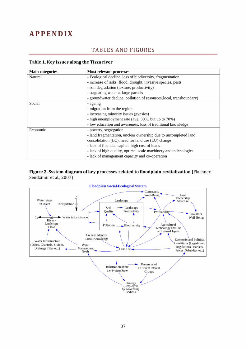
37
A P P E N D I X
TABLES AND FIGURES
Table 1. Key issues along the Tisza river Main categories Most relevant processes Natural - Ecological decline, loss of biodiversity, fragmentation
- increase of risks: flood, drought, invasive species, pests - soil degradation (texture, productivity) - stagnating water at large parcels - groundwater decline, pollution of resources(local, transboundary)
Social - ageing - migration from the region - increasing minority issues (gypsies) - high unemployment rate (avg. 30%. but up to 70%) - low education and awareness, loss of traditional knowledge
Economic - poverty, segregation - land fragmentation, unclear ownership due to uncompleted land consolidation (LC), need for land use (LU) change - lack of financial capital, high cost of loans - lack of high quality, optimal scale machinery and technologies - lack of management capacity and co-operation
Figure 2. System diagram of key processes related to floodplain revitalization (Flachner – Sendzimir et al., 2007)
Floodplain Social-Ecological System
Landscape
Land Use
Water in Landscape
Precipitation
Water Infrastructure(Dikes, Channels, Sluices,
Drainage Tiles etc.)
Water Stagein River
River -Landscape
Flow
SoilQuality
LandscapeProductivity
AgriculturalTechnology and Useof External Inputs
Profitability
CommunityWell-Being Land
OwnershipStructure
Biodiversity
InvestorsWell-Being
Pollution
Economic and PoliticalConditions (Legislation,Regulations, Markets,Prices, Subsidies etc.)
Information aboutthe System State
Strategy(Employed
by GoverningBodies)
Pressures ofDifferent Interest
Groups
WaterManagement
Goals
Cultural Identity,Local Knowledge
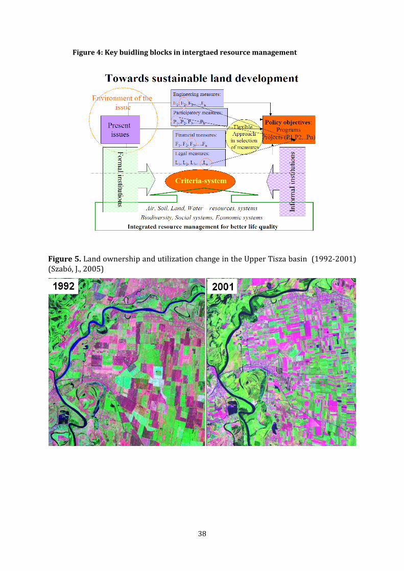
38
Figure 4: Key buidling blocks in intergtaed resource management
Figure 5. Land ownership and utilization change in the Upper Tisza basin (1992-2001) (Szabó, J., 2005)

39
PROJECT LOGICAL FRAMEWORK MATRIX Goal: Integrated land development (ILD) program to improve land use and water management efficiency in the Tisza basin
Objectively verifiable indicators Project Strategy
Indicator Baseline value Target (EOP) Value Sources of
Verification Risks and Assumptions
Project Objective: To develop integrated land and water management protocol through case studies to support efficient water and land management at areas with high risk (drought, stagnating water, flood, biodiversity loss)
a) ILD Protocol based on Tisza catchments countries legislation and governance
b) At selected pilots sites ILD implemented
c) Water management measures to support water retention capacity development and lowering risk at low and medium elevations – plan and implementation for Nagykörő basin
a) Zero b) Some initiative can be used as input for development (eg. Jánd), but comprehensive approach did not take place so fare. c) Zero. Water infrastructure (drainage, pumping stations, irrigation) are for drainage and not supporting multifunctional purposes
a) one protocol specified for min. 2 other countries
b) HU – 1 pilot implementation, 1 massive training, Ro- RS pilots are developed – feasibility, project proposal prepared
c) Affected parcels channels will be modified to support multipurpose goals
Project documentation and approval of the Advisory Board Pilot maps and reports Plan and report of implementation
Protocol developed will be not officially approved by the end of the project due to long term bureaucracy. During implementation global trade will collapse, big crises occur. EU CAP subsidy structure un-flexibility can block parcel formulation. Insufficient cooperation among farmers for redefining the water management at the basin .
Outcome 1: ILD Protocol based on Tisza catchments countries legislation and governance, decision making framework
zero 1 Report of the project Rapid response from each country teams – support is needed from the coordination agencies
Output 1.1 Legal overview of the 3 participating countries, general comparison for all Tisza countries by questionnaire
zero 1 Assessment report based on all Tisza countries contributions
Not enough support from non participating countries (Sk, UA)
Output 1.2 Analysis of legal constrains through the implementation of the pilot sites
Undivided joined property and LU change are identified problems – proper efficient tools are not available in HU
New legislation draft harmonized with existing ones
Approval of the Land Use Change at pilot site Lessons for national level
Low political awareness, interest conflict, low cross sectoral cooperation
Output 1.3 Recommendation on good governance for sub-catchments, small landscapes in light of the proposed changes for water retention areas in the Tisza basin
Not existing Proposal for governance Common report for all participating countries ILD documentation toolkit
Acceptance of outcomes not guaranteed/insecure

40
Objectively verifiable indicators Project Strategy
Indicator Baseline value Target (EOP) Value Sources of
Verification Risks and Assumptions
Outcome 2: ILD at selected sites implemented zero 2 minimum Local maps, land registry
Change of national or EU legislation, unpredicted problem with ownerships/owners
Output 2.1. Data and information system locally to support the ILD process, including economic data on local business and ecological services
Based on existing data – land categories, agriculture figures- need for integration and further data collection on ecosystem services and benefits from LUC
1 system prototype Project reporting Integration of data due to diverse methods of data collection (especially soft and hard)
Output 2.2. Elaboration of different LUC alternatives by participative processes on LD alternatives for the selected sites – based on DTM, water balance
zero Selection of potential sites, parcels for implementation
Agreement at pilot sites for combination of solutions
Missing flexibility of sites,
Output 2.3. Water management measures planned and verified by water-board (WB) and water directorate (WD) at selected sub-basins/sites Implemented ILD at selected sites, including measures for water steering improvement where it is appropriate
Base: present management and plans
Approved version of management plans for 4 sites 1 site implementation in HU
Water board management plan ILD documentation (agreements, land registry changes, etc.)
Time for authorization of plans, changes Cost of measures – need to search for additional funding in that case, strong cooperation with WD and WB is needed
Outcome 3. Dissemination of ILD concept and the results in the Tisza basin and at UNDP- ICPDR level
Zero (basic ideas from FARLAND and FAO projects are available)
Outreach in the participating communities and in the Tisza basin
ICPDR reports High costs – need collaboration with partners
Output 3.1 Trainings at location of implementation and at the partners locations (SR, Ro)
zero At 2 HU pilots and in the participating countries (Ro, SRG)
Training material and WS reports
Limited outreach of the project
Output 3.2 ILD toolkit book + CD zero 1 Publication Harmonization of text – to fit for all Tisza basin countries
Output 3.3. Final Stakeholder Workshop to evaluate the process and to approve the recommendations
zero 1 final SH workshop WS report Low political support

41