insert client name
TRANSCRIPT

541h
The Amulsar Gold Project
Environmental & Social Impact Assessment Non-Technical Summary
May 2016

This document is a Non-Technical Summary (NTS) of the Environmental and Social Impact Assessment (ESIA) for the Amulsar Gold Project. It provides a summary of the Project and its related ESIA process and provides information on the systems developed to manage the predicted environmental and social impacts of the Project’s activities during all phases from
construction to closure. This document and the complete ESIA report are publicly available on the Amulsar Gold Project websites at:
• Lydian International – in English: http://www.lydianinternational.co.uk/
• Geoteam – available in Armenian and English: http://www.geoteam.am/en/ http://www.geoteam.am/
Local stakeholders can access more detailed information in a variety of different ways, including through locally based
Community Liaison Officers (CLOs), members of Community Liaison Committees (CLC) and at the Amulsar Information Centre (AIC) located in Gndevaz, where posters, brochures and videos provide information on the ESIA process and findings. A
printed copy of the ESIA in Armenian is available for reference in the AIC in Gndevaz and at the Lydian-Geoteam office in Yerevan. Digital copies are also available at these locations. Lydian's Stakeholder Engagement Plan (SEP), which outlines the
company's approach to involving interested parties as the Project proceeds, is also available.
This ESIA will be available at the headquarters and Yerevan offices of the International Finance Corporation (IFC) and the European Bank for Reconstruction and Development (EBRD).
For more information on the issues outlined in this report, to ask questions or provide feedback, please contact
[email protected] in English or [email protected] in Armenian.
This international ESIA report is made available to key Armenian Government departments, such as the Ministry of International Economic Integration and Reforms (MIEIR), the Ministry of Economy (ME), the Ministry of Nature Protection
(MNP), the Ministry of Energy and Natural Resources (MENR), the Ministry of Territorial Administration and Emergency Situations (MTAES) and the Ministry of Urban Development (MUD), as well as other relevant Government agencies, academic,
civil society, local government and community groups. It will also be circulated to relevant financial institutions.

The Amulsar Gold Project Environmental & Social Impact Assessment Non-Technical Summary
May 2016 i
CONTENTS EXECUTIVE SUMMARY .............................................................................................................................................................. III
1 INTRODUCTION ............................................................................................................................................................... 1 1.1 Overview of the Amulsar Gold Project ...........................................................................................................................1
1.2 The ESIA ...........................................................................................................................................................................3 1.3 How the ESIA has been summarised in this NTS ............................................................................................................4
2 PROJECT DESCRIPTION .................................................................................................................................................... 5 2.1 Phases of the Project .......................................................................................................................................................5
2.2 Permitting status .............................................................................................................................................................5 2.3 Land acquisition ...............................................................................................................................................................6
2.4 Employment and working hours .....................................................................................................................................7 2.5 The layout of the mine ....................................................................................................................................................7 2.6 Mining operations ........................................................................................................................................................ 11
2.7 Closure and post-closure monitoring........................................................................................................................... 15 3 PROJECT IMPACTS AND ENVIRONMENTAL AND SOCIAL MANAGEMENT ..................................................................... 15
3.1 Introduction .................................................................................................................................................................. 15 3.2 Landscape and visual amenity ...................................................................................................................................... 16
3.3 Water resources ........................................................................................................................................................... 20 3.4 Biodiversity and ecosystems ........................................................................................................................................ 26
3.5 Society: demographics, economics, livelihoods, and land use ................................................................................... 31 3.6 Community health, safety and security ....................................................................................................................... 38
3.7 Air quality ...................................................................................................................................................................... 40 3.8 Greenhouse gas emissions and climate change .......................................................................................................... 43
3.9 Noise and vibration....................................................................................................................................................... 44 3.10 Transport services and Infrastructure.......................................................................................................................... 46
3.11 Archaeology and cultural heritage ............................................................................................................................... 48 3.12 Ecosystem services ....................................................................................................................................................... 51
4 CUMULATIVE IMPACTS ................................................................................................................................................. 52
4.1 What are the potential cumulative impacts associated with the Project? ................................................................ 53 4.2 What will be done to manage or control the cumulative impacts? ........................................................................... 53
5 PROJECT ALTERNATIVES ................................................................................................................................................ 54 5.1 Project technology alternatives ................................................................................................................................... 54
5.2 Alternatives for location of Project infrastructure ...................................................................................................... 55 6 ENVIRONMENTAL AND SOCIAL MANAGEMENT PLAN .................................................................................................. 56
7 STAKEHOLDER ENGAGEMENT ....................................................................................................................................... 56 8 PUBLIC PARTICIPATION ................................................................................................................................................. 59

The Amulsar Gold Project Environmental & Social Impact Assessment Non-Technical Summary
May 2016 ii
TABLES Table 1: Summary of the duration of each phase of the Project .......................................................................................................5
Table 2: Main components of the mine ..............................................................................................................................................9 Table 3: Project-affected land .......................................................................................................................................................... 36
Table 4: Public meetings and consultations held with Amulsar Gold Project stakeholders .......................................................... 58
FIGURES Figure 1: Location of Amulsar Gold Project in Armenia ........................................................................................... 1 Figure 2: Planned layout of Amulsar Gold Mine .................................................................................................... 3
Figure 3: View of Amulsar looking towards the planned location of the open pits ......................................................... 8 Figure 4: Lake Sevan Impact Zones after Government resolution 749-N.................................................................... 10
Figure 5: Example of a drill rig in an open pit ..................................................................................................... 11 Figure 6: Schematic section through an open pit showing bench construction (not to scale) .......................................... 12
Figure 7: Example of excavator loading a haul truck in an open pit .......................................................................... 12 Figure 8: Schematic of how gold is leached from the heap and how cyanide is contained by a composite lining system ....... 14
Figure 9: Environmental and social study boundaries ........................................................................................... 16 Figure 10: View from Hotel Olympia, Jermuk ..................................................................................................... 18
Figure 11: View from H-42 Road south of Gndevaz .............................................................................................. 19 Figure 12: View from minor road through Vorotan Valley ..................................................................................... 20
Figure 13: Surface water and main water catchment boundaries ............................................................................ 21 Figure 14: Example of a Potentilla porphyrantha plant ......................................................................................... 27 Figure 15: Brown bear on Amulsar Mountain ..................................................................................................... 27
Figure 16 Egyptian vulture............................................................................................................................. 28 Figure 17: Community land boundaries and seasonal herder camps, with project infrastructure .................................... 31
Figure 18: Herder with flock of sheep in the area around Amulsar .......................................................................... 32 Figure 19: Apricots ...................................................................................................................................... 33
Figure 20: Social land use .............................................................................................................................. 35 Figure 21: Estimated total dust deposition from the mining activities ...................................................................... 42
Figure 22: Predicted daytime operational noise .................................................................................................. 45 Figure 23: Access junctions to the Project ......................................................................................................... 48
Figure 24: Possible bronze age tomb found in the Vorotan River valley, outside the Project-affected area ........................ 50 Figure 25: Main project technology alternatives ................................................................................................. 55
Figure 26: Information centre in Gndevaz during the opening ceremony .................................................................. 58

The Amulsar Gold Project Environmental & Social Impact Assessment Non-Technical Summary
May 2016 iii
EXECUTIVE SUMMARY Lydian’s proposed Amulsar Gold Project comprises the extraction, via blasting and excavation, of ore from three open pits on Amulsar Mountain; crushing of the ore and transportation via conveyor to a heap leach facility (HLF) where gold and silver are leached into solution using sodium cyanide; and extraction of the precious metals from the solution at an adsorption-desorption recovery (ADR) plant. Barren rock from the pits will be stored in an engineered barren rock storage facility (BRSF). The Project will have a life of approximately 12 years, including two years of construction. The Project environmental and social impact assessment (ESIA) has been undertaken in compliance with the standards of the International Finance Corporation and the European Bank for Reconstruction and Development as current shareholders of Lydian. It is designed to meet best international practice as exemplified by the standards of these development banks. The mine site is in a rural, upland area, with much of the footprint located on meadowland used for animal grazing, except for the HLF and part of the conveyor which are located at lower elevation on private- and community-owned land near to the villages of Gndevaz and Saravan. Some 274 plots of private land totalling 152 ha, mostly belonging to Gndevaz residents, are to be acquired by the Project. Assistance will be provided to one local resident, currently living near the HLF site, to relocate to develop this as a Primary Monitoring Station for measurement of noise, air quality and blasting vibration. There is no requirement for wider physical resettlement, but some cultivated land will be lost resulting in economic displacement. The land will be acquired through a negotiated settlement with each land user and/or owner. Landowners will be offered either land-for-land replacement or cash compensation; land users will be compensated for lost crops. Care will be taken to identify and provide additional assistance to particularly vulnerable households. Agriculture is the primary source of livelihood in the communities surrounding the Project. The upland areas are used in summer by seasonal animal herders and for foraging. While most agricultural produce is for home consumption, the village of Gndevaz is renowned for its commercial production of apricots. The nearby town of Jermuk is designated as an Armenian “Tourism Centre”, has a water bottling facility and is known for its mineral water and spas. As with many rural areas in Armenia, the local communities are experiencing low-level out-migration at present, as residents seek employment opportunities elsewhere. Approximately 1,300 people will be employed during mine construction, and 657 during operation. The Project will prioritise local recruitment. A comprehensive training programme is being established to support local residents in becoming “employment ready” for the operations phase. While Project employment is expected to benefit the communities, it will also represent a transition away from traditional lifestyles. Access to areas which are used to graze animals and collect plants and herbs will be partly restricted by the presence of Project infrastructure. The direct and indirect employment opportunities presented by the Project may serve as an attraction to in-migrants, potentially raising the local population and increasing the demand for goods and services. Increased demand, coupled with increased disposable income from mining wages, could in turn generate localised inflation. Lydian will work with local communities and government to minimise and manage the potential negative social impacts of the Project, through regular monitoring, information dissemination and awareness training, stakeholder engagement, and the administration of a community grievance mechanism. The distances between Project infrastructure and the local communities are such that air pollution, noise, vibration and dust generated by the Project will not significantly affect local people. Nevertheless, these effects can disturb and have impacts on other receptors, such as wildlife. Traffic impacts will be controlled by appropriate management. Groundwater within the Project area feeds springs and recharges the main rivers, which include the Vorotan, Arpa

The Amulsar Gold Project Environmental & Social Impact Assessment Non-Technical Summary
May 2016 iv
and Darb. Spring and river water is used variously for drinking and irrigation supply, in fish farming and for hydroelectric power generation. A fundamental principal of Project design is that discharge of process water – which includes water used in the mining process, contact water and seepage from the barren rock facility – will be minimised and will only take place after passive treatment to comply with Armenian ambient water quality standards. Run-off and non-contact water discharge will also be compliant with all the appropriate standards. A comprehensive monitoring programme will be in place to ensure the efficacy of the treatment system. Modelling shows that the Project’s use of Arpa river water will not affect the availability of water for other users. Aquifers will not be significantly impacted by mining operations. Furthermore, a detailed study has shown that there is no physical connection between groundwater beneath the Project site and the source of the mineral water used and bottled at Jermuk. The majority of the Project will be located on areas of natural vegetation and habitat, the exception being parts of the HLF which are currently cultivated. The natural habitats are host to several rare or threatened animal and plant species. Of particular note are the alpine plant, Potentilla porphyrantha, which is listed as “critically endangered” in the Armenian Red Book and is present on the rocky mountain tops of Amulsar; and Ursus arctos (Brown Bear), which feeds and hibernates on or around the mountain. The alpine grassland on the lower mountain slopes hosts several migratory bird species, some of which, including Egyptian Vulture and Lesser Kestrel, are key features of the nearby and internationally designated Jermuk and Gorayk Important Bird Areas. The Project will result in the loss of natural vegetation, including habitat for both Potentilla porphyrantha and Ursus arctos that, according to international standards, is designated as “critical habitat”. Mining will also reduce the quality of habitats as a result of noise and dust deposition, and by blocking animal movement. Potential impacts on biodiversity will be reduced to the extent possible by the implementation of management measures and by post-mining restoration. To compensate for the loss of natural habitat, Lydian will establish a “biodiversity offset” which will aim to ensure that there is no net loss of such habitat as a result of the Project. For Potentilla porphyrantha and Ursus arctos, Lydian is undertaking research programmes to determine whether additional mitigation measures may be necessary to ensure no net loss in relation to these species. The Project will result in changes to the landscape that will not be fully restored to its pre-existing condition when mining is finished. All infrastructure and facilities will be removed, and sites will be rehabilitated and returned for community use when possible. However, restrictions on future use of the partially-backfilled mine pits and heap leach site will remain for long term monitoring. These elements will change the local landscape permanently, though not to an extent that is significant within the wider region. Surveys have identified 81 potential archaeological sites that are likely to be impacted by Project development, although none of these is considered by Armenian and international cultural heritage experts to be of high importance. A “chance finds procedure” will be in place at all times to ensure that any significant new site or artefact discovered during Project implementation can be recorded, investigated and removed or excavated as appropriate. Stakeholder engagement is a core value of Lydian. During the exploration, pre-feasibility and feasibility phases, the main aim of stakeholder engagement has been to establish two-way communication between Geoteam and stakeholders at national, regional and local levels to ensure stakeholder views are incorporated into the ESIA and Project design. Good relationships with local communities have supported the development of exploration activities. The Project will implement a comprehensive Environmental and Social Management Plan (ESMP) to govern the implementation, management and monitoring of the mitigation measures that the ESIA has identified as being necessary to control the environmental and social impacts of the Project. A total of 19 discipline-specific management plans have been developed as part of the ESMP. A comprehensive Environmental and Social

The Amulsar Gold Project Environmental & Social Impact Assessment Non-Technical Summary
May 2016 v
Management System (ESMS) is currently under development to implement the commitments made in the ESIA, during construction as well as during operations.

The Amulsar Gold Project Environmental & Social Impact Assessment Non-Technical Summary
May 2016 1
1 INTRODUCTION Lydian International Ltd (Lydian) discovered a gold deposit on the Amulsar mountain ridge in central Armenia in 2006 (see Figure 1). Lydian has now carried out both a Feasibility Study and an Environmental and Social Impact Assessment (ESIA) for mining and processing of the discovered gold. This document is the Non-Technical Summary (NTS) of the ESIA. The proposed development has been named the Amulsar Gold Project, but is also referred to as ‘the Project’ within this document.
Figure 1: Location of Amulsar Gold Project in Armenia
1.1 Overview of the Amulsar Gold Project The Project is located in a mountainous area with undulating hills, river valleys and more gently sloping farmland at lower elevations. Access to the Project is off the M-2 Magisterial road, via the H-42 Republic road which is the main road to Jermuk. The communities closest to the Project are (see Figure 2): • Jermuk, located 5km to the north of the Project; • Kechut, located 4km to the north of the Project;

The Amulsar Gold Project Environmental & Social Impact Assessment Non-Technical Summary
May 2016 2
• Gndevaz, located 1km from the western edge of the Project; • Saravan, including the settlements of Saralanj and Ughedzor, 2km to the south of the Project; and • Gorayk, located 4km to the south-east of the Project. Once operational, the Project will comprise: • The extraction of gold (and silver) ore from three open pits, Artavazdes, Tigranes and Erato, using
standard open-pit mining techniques including drilling and blasting followed by loading of the ore and barren rock into haul trucks via large excavators;
• Transport of the ore to a crusher facility for size reduction; • Transport of the crushed ore via a covered conveyor to the processing area known as the heap leach
facility (HLF); • Transport of barren rock material by haul trucks to the barren rock storage facility (BRSF); • Placement of layers of crushed ore on the heap leach pad followed by the dripping of a cyanide solution
through the heap to dissolve the gold and silver, to be collected via a drainage system; and • Extraction of the metals from the cyanide solution at the Adsorption-Desorption Recovery (ADR) plant and
processing to an alloy of semi-pure gold and silver (doré). The planned layout of the mine is shown in Figure 2. The Project life will extend over 12 years, including two years of construction and 10 years of active mining and processing, followed by closure. Once mining ends the site will be closed and the affected land reclaimed and rehabilitated. After a period of post-closure monitoring, most of the restored land will be returned to the local communities or government. There will, however, be areas that, although posing no risk of harm to the local communities, will not be suitable for use due to topographical considerations (steep slopes). These include the HLF and the former open pits. The final plans for the closure phase will be updated as the Project develops, with a final closure plan being available at least two years before mine closure. Approximately 1,300 people will be employed during the two-year construction phase. The non-local workforce will be accommodated in hotels and apartments in Jermuk and potentially in the surrounding communities; in addition on-site provision will accommodate between 500 and 920 workers to address peak workforce requirements and/or at other times when local hotels are occupied by tourists. During the operational phase, approximately 657 people will be employed, all of whom will live either in their own homes, apartments and hotels in Jermuk, or in the worker accommodation camp.

The Amulsar Gold Project Environmental & Social Impact Assessment Non-Technical Summary
May 2016 3
Figure 2: Planned layout of Amulsar Gold Mine
1.2 The ESIA The ESIA, which was written by Wardell Armstrong International (WAI) and other expert consultants, was published in May 2016 and contains the following: • A review of the policies, laws and regulations that the Project must comply with as it is developed and
operated. These include both Armenian legal requirements and international standards which Lydian has committed to apply, such as the International Cyanide Management Code (ICMC), the International Finance Corporation Performance Standards (IFC PS), and the European Bank for Reconstruction and Development Performance Requirements (EBRD PR);
• A detailed description of the mining and industrial processes that will be employed; • An assessment of alternative mining and processing methods that were considered, and an account of
how the proposed locations of major items of Project infrastructure were selected, including illustrations of how environmental sensitivities and stakeholder considerations informed these choices;
• A description of the environmental and social 'baseline' conditions in the Project area, including physical,

The Amulsar Gold Project Environmental & Social Impact Assessment Non-Technical Summary
May 2016 4
biological, social and cultural elements; • The impact assessment, which predicts the potential impacts the Project will have on baseline conditions,
taking account of feedback from stakeholders including those residing in affected communities, local government, businesses, and other interested organisations;
• Identification of mitigation measures required to avoid, minimise and manage negative impacts (or enhance positive impacts), and which may apply to the engineering design, construction, operation or closure phases of the Project;
• An assessment of cumulative impacts associated with the Project; and • The ESMP for the Project, which provides for implementing and monitoring the effectiveness of the
identified mitigation measures during the life of the Project. The Project has previously gone through the Environmental Impact Assessment (EIA) approval process set forth under Armenian legislation. The regulatory EIA is an integral part of the permitting process required to obtain the Mining Right. The EIA process involved a number of public hearings, and it was reviewed and approved by the Ministry of Nature Protection (MNP), related organizations outside the MNP, and individual independent experts. The approval of the EIA was originally granted by the MNP on the 17th of October, 2014. In 2015, a Value Engineering and Optimization (VE) exercise was undertaken by Lydian. This resulted in the publication, in November 2015, of a new Feasibility Study for the Project. As a result of design changes arising from the VE exercise, a revised EIA will be submitted to the MNP in 2016. The international ESIA which this NTS summarises is consistent with both the new Armenian EIA requirements and includes the 2015 Feasibility Study. 1.3 How the ESIA has been summarised in this NTS The main focus of this document is to clearly communicate to all stakeholders the planned Project activities and how potential environmental and social risks and impacts will be managed. Chapter 2 provides a brief Project description. Chapter 3 summarises the results of the baseline studies and impact assessment process for each environmental and social component, using questions as sub-headings: • What is the present state of the environmental or social baseline component? • What are the potential impacts from the Project activities? • What will be done to manage or control the impacts? • What risks and impacts will remain? Chapter 4 summarises the cumulative impacts of the Project, taking account of other potential developments or background trends in the locality. The potential alternatives considered in the Project design process are summarised in Chapter 5. The approach to implementing the ESMP is described in Chapter 6. Chapters 7 and 8 address, respectively, the stakeholder engagement and public participation that have informed the ESIA and will be a continuing aspect of Lydian's management of the Amulsar Gold Project.

The Amulsar Gold Project Environmental & Social Impact Assessment Non-Technical Summary
May 2016 5
2 PROJECT DESCRIPTION 2.1 Phases of the Project The Project will include the following phases: • Design: Continuation of the design process, with further detail and refinement; • Construction: Stripping of vegetation, soil and overburden (with stockpiling of soil for use during
restoration) and construction of all facilities and infrastructure required for mine operations; • Operations: Mining of ore from three open pits, phased over the life of the Project; placement of barren
rock in the BRSF (with some used to partially backfill the Tigranes-Artavazdes pits); and heap-leaching and processing of the ore to produce doré for export;
• Closure: Removal of all mining and processing infrastructure and reclamation of affected land, aiming to restore existing vegetation types and habitats; and
• Post-closure Monitoring: To continue for a minimum of five years. Table 1 gives a summary of the timing of each phase of the Project.
Table 1: Summary of the duration of each phase of the Project Project Phase Year and Time Period Key Project Activities
Design Year 0 Final design, detail engineering and refinement
Construction Years 1-2 (2 years) Construction of Project infrastructure
Operations
Year
s 3-1
2 (1
0 yea
rs) Years 3-5 (3 years)
Extraction of barren rock and ore from Tigranes/ Artavazdes open pit; crushing and leaching of ore; recovery of gold
Years 6-12 (7 years) As for years 3-5, and includes the Erato open pit
Closure Years 13-14 (2 years) Rinsing of heap leach pad, dismantling of infrastructure, reclamation and revegetation of land
Post-Closure Monitoring Years 15-19 (5 years) Monitoring particularly of the HLF and BRSF after
rehabilitation 2.2 Permitting status The mining sector in Armenia is regulated by the Mining Code, which was adopted in January 2012. The key permit is the Mining Right, which triggers the process for obtaining other permits required for the operations phase. Under the Mining Code, the applicant should submit to the Ministry of Energy and Natural Resources (MENR) a Mining Permit application consisting of four main separate documents: (1) Mining Plan; (2) EIA; (3) Technical Safety Programme (TSP); and (4) Mine Closure Plan.

The Amulsar Gold Project Environmental & Social Impact Assessment Non-Technical Summary
May 2016 6
Once positive resolution from the ministries reviewing the application documents is issued, the applicant prepares a Mining Agreement and an application for the Rock Allocation Area (RAA). When the Mining Agreement is signed with MENR, then with an approved RAA the applicant receives the formal Mining Right. A comprehensive Mining Permit application was submitted in July 2014, with the documentation consistent with the 2014 Feasibility Study and the ESIA. Positive opinion of the TSP and the EIA were granted respectively by the Ministry of Emergency Situations in August 2014 and the MNP in October 2014. The Mining Agreement discussion took place in November 2014, as an amendment to the existing September 2012 agreement. The Mining Right for the project was granted on 26 November 2014. As a result of the VE exercise (see Section 1.2 above), a revised Mining Permit application has been granted on 28 April 2016. 2.3 Land acquisition The land required for construction and operation of the Project is primarily located within areas owned by residents of Gndevaz and Saravan. Some land required for infrastructure, including the crushers, conveyor, ADR plant, BRSF and haul roads, will only be required for the 12 year construction and operational period and will then be restored and transferred to community ownership. However, the HLF, located in the territory of Gndevaz, will not be usable post-mining because the slopes are too steep for safe agricultural operations and ongoing post mining monitoring, and the land will therefore be acquired permanently. The direct physical footprint of the Project is 597ha. In addition to this, approximately 1168ha of land around the main infrastructure will be subject to access restrictions for safety purposes, or will otherwise be affected by operations, during the Project life. Of this overall total of approximately 1,765ha, about 152ha comprise privately-owned plots: • HLF area: 252 private land plots consisting of approximately 139ha of arable land, orchards and
pasture/hay land, to be acquired permanently for the Project; and • Conveyor: 22 private land plots to be acquired for the construction and operation phases covering a total
area of 13 ha. The numbers above reflect the situation at the time of the planning for the land acquisition. They may be subject to revision. The land acquisition process will comply with both Armenian law and the requirements of IFC PS 5 and EBRD PR 5, which represent international good practice in the process of land acquisition. The process is based on negotiated settlements, with expropriation used only as a last resort if all avenues for amicable settlement have been exhausted. The identification of affected plots and owners/users is based on official cadastral information, complemented by field surveys. The Project has been designed to avoid physical displacement, and resettlement of only one local resident is has been agreed by negotiated settlement; the property will be used as the Primary Monitoring Station for noise, air quality and ground vibration for the duration of the Project. However, there will be economic displacement, with resulting impacts on people's livelihoods. The Project will compensate for all such impacts on livelihoods. Affected owners of arable, orchard and pasture land have been offered land-for-land compensation. Those who prefer cash compensation have been offered sums (for both land and crops) calculated at full replacement value and paid before the land is acquired. As of mid-February 2016, approximately 85% of the required land has been obtained based upon negotiated settlements.

The Amulsar Gold Project Environmental & Social Impact Assessment Non-Technical Summary
May 2016 7
An information booklet for villagers, the Guide to Land Acquisition and Compensation (GLAC), was published in June 2014 in English and Armenian, and disclosed via community newsletter, community meetings, at the Amulsar Information Centre located in Gndevaz, and placed on the Geoteam website. A Land Acquisition and Livelihood Restoration Plan (LALRP), which is fully compliant with the IFC and EBRD international good practice, was prepared in January 2015 and publicly disclosed in March 2015. An addendum to the LALRP was published in February 2016. These documents are consistent with and incorporate the provisions of the GLAC.
2.4 Employment and working hours The mine will generally operate for 24 hours a day, seven days per week. Allowing for shut-down periods for planned maintenance and other aspects of mine development, the mine is expected to operate for 350 days per year. This takes account of severe weather conditions, mostly experienced during the winter months. The projected number of employees during each phase of the Project will be approximately: • 1,300 during the peak of the construction phase; • 657 during the operational phase; and • 20 for post-closure monitoring and maintenance with the workforce gradually reducing after mine
closure. The Project will source workers from the neighbouring towns and villages. Local recruitment will be prioritised. Positions that cannot be filled by Armenians will be staffed with suitably qualified expatriates on fixed-term contracts. 2.5 The layout of the mine Figure 3 is a photograph showing the peaks of Amulsar Mountain, overlooking the location of the proposed open pits in the direction of North Erato. The temporary access tracks in the foreground, which were used for exploration, are in the process of being restored.

The Amulsar Gold Project Environmental & Social Impact Assessment Non-Technical Summary
May 2016 8
Figure 3: View of Amulsar looking towards the planned location of the open pits
Table 2 identifies the main components of the mine together with a brief description (as labelled on Figure 2).

The Amulsar Gold Project Environmental & Social Impact Assessment Non-Technical Summary
May 2016 9
Table 2: Main components of the mine
Component Description
Open pits
Three open pits will be excavated to access the separate ore bodies known as Tigranes, Artavazdes and Erato. Tigranes and Artavazdes will merge into a single open pit during the life of the mine. Ore and the surrounding barren rock will be excavated from the open pits using face shovels and haul trucks.
Haul roads Haul roads will be constructed for trucks to transport ore and barren rock from the open pit to other areas of the mine site.
Barren Rock Storage Facility (BRSF) Located in a valley on the mountain side, this will be designed to store barren rock from the open pit. This will be a permanent storage facility.
Crushing area
The crushing plant will reduce the size of the ore in a series of crushers and screens. The crushed ore will be screened so that rocks that remain too large after the first pass can be crushed again. The crushing plant design is to reduce all rock fragments to a size less than 19 millimetres.
Conveyor The overland conveyor will run down the mountainside, transporting crushed ore from the crushing area to the Heap Leach Facility (HLF).
Heap Leach Facility (HLF)
Crushed ore will be placed in stacks and a dilute solution of sodium cyanide will be dripped onto the pile to leach out gold and silver as it trickles through the heap and drains to solution ponds. There will be no release of cyanide solution to the external environment.
Solution Ponds The solution ponds collect the gold-rich solution (also known as pregnant solution) after it drains from the base of the heap leach stockpiles.
Adsorption-Desorption Recovery (ADR) Plant
This plant recovers gold and silver from the pregnant solution and produces semi-pure gold/silver doré bars which will be exported for further refinement.
Workshops Workshops will contain equipment and space for the maintenance of plant and equipment used at the mine.
Access roads Used for light vehicle traffic to access the mine site from the main roads and to travel throughout the mine.
Power supply A new substation will be constructed to take power from the existing 110kV line which traverses the site.
Water supply Water will be obtained from the Arpa River to supplement water collected from site run-off.
Worker Accommodation Camp During the construction phase on-site worker accommodation will be established for between 500 and 920 persons with the remaining workforce living in their own homes or in hotels and apartments in Jermuk and the surrounding communities.
The location of Project infrastructure takes account of Government Resolution 749-N that defines the Lake Sevan Immediate Impact Zone to include a zone on either side of the underground tunnel connecting Spandaryan Reservoir to Kechut Reservoir (see Figure 4). Mineral processing is not permitted in the Immediate Impact Zone; the HLF is therefore located outside this zone. The proposed HLF site was selected by a Joint Working Group that consisted of senior representatives from Lydian and from the Armenian Government. The Ministry of Economy, the MENR, the MNP, the Ministry of Urban Development and the State Committee of the Real Estate Cadastre were all included in the decision-making process. The Sevan Committee also endorsed the current design during the permitting of the Project.

The Amulsar Gold Project Environmental & Social Impact Assessment Non-Technical Summary
May 2016 10
Figure 4: Lake Sevan Impact Zones after Government resolution 749-N

The Amulsar Gold Project Environmental & Social Impact Assessment Non-Technical Summary
May 2016 11
2.6 Mining operations 2.6.1 Open pit mining Open pits are used when ore bodies are located close to, and can be mined from, the ground surface. Mining operations at the Project will excavate rock from the pit, separating: • Ore, which is rock that contains concentrations of gold (and silver) that can be processed economically;
and • Barren rock, which is the rock surrounding the ore body that has to be removed to access the ore. This
rock will be transported to the BRSF. During mining operations, approximately 97 million tonnes (30%) of the rock excavated from the open pits will be classified as ore, and 229 million tonnes (70%) as barren rock. Blasting is a standard technique used in mining to loosen and break up the rock mass. This will be achieved by drilling a series of regularly spaced holes into the rock, packing explosives into the holes and then detonating a series of controlled explosions (see Figure 5 for an example of a drill rig). The explosions break up the rock and allow the rocks to be removed by excavators. The arrangement of drill holes and quantity of explosives will be designed so that the explosion is only as large as needed to sufficiently break up the rock in a controlled manner.
Figure 5: Example of a drill rig in an open pit
Drilling and blasting will be conducted to form a series of benches (Figure 6). The benches will be wide enough to accommodate haul roads to enable haul trucks to reach the bottom of the pit.

The Amulsar Gold Project Environmental & Social Impact Assessment Non-Technical Summary
May 2016 12
Figure 6: Schematic section through an open pit showing bench construction (not to scale)
Excavators will be used to load the ore or barren rock from the blast pile into haul trucks (Figure 7). Haul trucks will transport the ore to the crushing plant and barren rock to the BRSF.
Figure 7: Example of excavator loading a haul truck in an open pit
The Amulsar Gold Project Environmental & Social Impact Assessment Non-Technical Summary
May 2016 13
2.6.2 Barren Rock Storage Facility (BRSF) This large mound will be constructed in layers from placed barren rock. The BRSF will increase in height as the mine develops, and its outer facing slopes will be overlain with soil and revegetated progressively during the life of the mine. Because of the potential for some of the barren rock excavated from the mine to be acid-generating when coming into contact with water, the BRSF has been designed to prevent the natural flow of surface water and groundwater from coming into contact with the stored rock. Rain water and snow-melt runoff will be prevented from flowing into the BRSF by a network of diversion channels and gulleys. These channels will direct surface water around the BRSF and drain to the Arpa River. Surface water from natural springs that flow within the footprint of the BRSF will be collected through a specialised drainage system in the base of the BRSF. This drainage system will prevent the water from coming into contact with the barren rock. The BRSF will not be enclosed, so rain and snow will land directly on the barren rock and seep into the facility. The seepage will drain through the BRSF and be contained by a compacted soil liner laid at the base of the facility. This water will then be piped to the HLF for use in the leaching process. 2.6.3 Processing ore to extract gold Crushing the ore to the required size Haul trucks will transport the ore to the crushing plant and tip the ore into a hopper that feeds the primary crusher. If for any reason the hopper is full, the ore will be tipped to a Run of Mine (ROM) stockpile. At a later time ore from this stockpile will be loaded to the feed hopper. The purpose of the crushing plant is to reduce the size of rocks containing ore to a uniform small sized aggregate that can be further processed to extract gold and silver in the HLF. The crushing plant will contain a series of crushers and screens to make the fragments of ore smaller. The ore will be crushed and screened until all fragments are smaller than 19mm. Conveying crushed ore to the HLF The next stage of the process is to take the crushed ore to the HLF using a covered conveyor system, which will transfer up to 28,000 tonnes of crushed ore per day to the truck loadout facility. The truck loadout facility removes ore from the conveyor and transfers it to haul trucks, which take the ore to the heap leach pad at the HLF, where it is spread in layers using bulldozers. Leaching gold from the ore At the HLF, a weak sodium cyanide solution is drip-fed over the surface of the placed ore from a piped network designed to produce an even coverage of solution within the ore pile. As the solution slowly percolates through the heap, the cyanide in the solution reacts with the gold (and silver) in the ore, which is dissolved and carried in the pregnant solution to the collection drains at the base of the heap. The drainage system directs the solution to the pregnant solution pond (Figure 8).

The Amulsar Gold Project Environmental & Social Impact Assessment Non-Technical Summary
May 2016 14
Figure 8: Schematic of how gold is leached from the heap and how cyanide is contained by a composite lining
system The drainage system beneath the heap is designed to contain the cyanide solution and any rain water and snowmelt that might land on the footprint of the heap leach pad. The system will use a low-permeability, double-lined composite lining system comprising clay and high-density plastic layers. Such composite liners are widely used throughout the world to control or prevent liquids percolating into groundwater. The composite lining system to be used in the HLF will prevent any solution containing cyanide from discharging into the environment. The pregnant solution will be pumped to the Adsorption-Desorption Recovery (ADR) plant. At the ADR plant, the solution will flow through a series of tanks containing activated carbon (comprising broken and charred coconut husks). The gold dissolved in the solution adheres (sticks) to the surface of the activated carbon particles through a process known as adsorption. In this way the gold (and silver) is selectively removed from the pregnant solution. The solution leaving the series of carbon columns is now known as the barren solution because the precious metal concentration in it is very low. The barren solution is mixed with fresh sodium cyanide and pumped back to the heap leach, where the solution is dripped back onto the heap, in a totally closed circuit. Producing semi-pure gold bars Carbon particles with gold stuck to the surface are removed from the columns and placed into a carbon-strip tank. The carbon particles are “washed” at relatively high temperature (around 130°C) and at pressure to remove the gold from the carbon. The concentrated solution, known as eluate, is processed to a gold/silver-rich sludge. This sludge is melted to produce the doré bars. Residual waste from the process will be stored temporarily on site until it can be disposed of in a licensed hazardous waste facility (to be identified).

The Amulsar Gold Project Environmental & Social Impact Assessment Non-Technical Summary
May 2016 15
2.7 Closure and post-closure monitoring Closure of the mine will be followed by a period during which equipment will be removed, and buildings and infrastructure will be dismantled. Parts and scrap will be removed from the site for reuse elsewhere, or for recycling or disposal. The closed drainage circuit of the HLF will be maintained and water will continue to be circulated through the heap for a period of at least two years after closure, until the cyanide concentration in the water draining from the heap has been reduced to safe level. This process is known as rinsing. Water discharging from both the HLF (after rinsing and detoxification) and BRSF is to be treated to reduce sulphate and chloride levels using a modular temporary treatment system initially and then a passive system as flows diminish, and monitored to confirm it meets water quality discharge standards. All land used by the Project is to be restored to the extent possible. Restoration will actually be a process that takes place progressively through the Project life, beginning immediately after the construction phase, when any temporary lay-down areas will be rehabilitated. Restoration of the Tigranes and Artavazdes open pits will commence during the mine's operational life, using barren rock from the Erato pit as backfill. However, the main restoration work will take place after closure. A research programme has been initiated, and will continue during Project implementation, to identify the best methods for revegetating the disturbed land with native species. Monitoring will determine whether the restoration measures taken are effective, whether further management is needed, and what the future, long-term needs for managing the land might be. The Erato pit will be partially backfilled with barren rock, to a level above the water table. The pit rim will be shaped to restrict access. It will not be possible to return all land used by the Project to the same condition or usage that it had before mining took place. Man-made landforms, including the HLF, BRSF, and partially-backfilled open pits, will be a permanent change to the landscape. The HLF and BRSF will have their outer slopes re-shaped to form a smooth profile, and will be covered with a clay cap to limit water seepage. Once the slopes have been sealed they will be covered with soil, and vegetation will be planted. The vegetation will be monitored and managed during the aftercare period. The HLF and open pit areas are unlikely to be capable of supporting the same grazing or agricultural land uses as they do now because of safety aspects related to slopes. Post-closure monitoring will continue for approximately five years. 3 PROJECT IMPACTS AND ENVIRONMENTAL AND SOCIAL MANAGEMENT 3.1 Introduction This chapter provides a brief summary of the baseline conditions and impact assessment presented in the ESIA for various environmental and social elements. Each subsection includes the following: • The state of the environmental or social element prior to Project implementation; • The impacts that may result from Project activities;

The Amulsar Gold Project Environmental & Social Impact Assessment Non-Technical Summary
May 2016 16
• Measures to be implemented to avoid, reduce or manage the impacts; and • Predicted impacts that may remain after the management measures are applied (known as residual
impacts). The studied geographical area varies slightly for each environmental or social element, but the general areas affected by the Project are shown in Figure 9.
Figure 9: Environmental and social study boundaries
3.2 Landscape and visual amenity Landscape character is considered to be important in its own right; is has intrinsic value regardless of whether it is seen by people. Impacts on visual amenity as perceived by people are a related potential impact. 3.2.1 Present landscape and visual conditions The Project area lies within a 'natural' landscape characterised by jagged rock exposures rising above smoother, grassed or forested mountains separated by deep, steep-sided gorges or river valleys. Amulsar is a peak of the north-south trending Zanghezur range, whose highest peak, Mount Kapoutjough, rises to 3,906 metres above sea level. The mountain peaks affected by the Project are North Erato, Erato, Tigranes, Artavazdes and Arshak. The craggy mountain tops drop down to more gently sloping, rounded hills and undulating grassy plateaus, extending between a network of river valleys which bounds the Project area: the Vorotan to the east, Darb to the south, and Arpa to the west.

The Amulsar Gold Project Environmental & Social Impact Assessment Non-Technical Summary
May 2016 17
3.2.2 What are the potential impacts on landscape and visual amenity? Construction and operation of the Project will result in changes to the landscape and changes in views from the surrounding area. During construction, infrastructure including access and haul roads, the conveyor, the crushing plant, and the ADR plant will be introduced to the landscape. During operation, the landform itself will be changed by the excavation of the open pits and the construction of the BRSF and HLF. These will result in permanent changes to the landscape. Other impacts will remain only until the end of the mine life, when the infrastructure will be dismantled and the land restored, with vegetation reintroduced to disturbed areas. Existing views towards Amulsar Mountain will change during construction and operation, with some changes caused by the open pits, HLF and BRSF being permanent. Views of the Project from the tourist resort of Jermuk will be possible from the construction phase of the Project, when the crushing and screening plant and the haul roads are constructed, and during the later stages of the operational phase when the Artavazdes-Tigranes pit is in operation and the BRSF has reached its maximum extent. The settlement of Kechut will also have visibility of the crushing and screening plant and haul roads, and more limited visibility of the BRSF from the later stages of the operational phase. The crushing and screening plant, parts of the conveyor, and access roads will be visible from parts of Gndevaz. The residents of Gorayk and the majority of those within the settlements of Saravan and Saralanj will not be able to see either the mine or its infrastructure. 3.2.3 What will be done to manage or control impacts? Various measures will be implemented to reduce impacts during construction and operation. Buildings and structures will be located to be screened by existing topography or vegetated earth berms where possible; external lighting will be kept to the minimum required for safety purposes; and buildings will be painted to blend in and reduce their perceptibility within the landscape. Throughout construction and operations, areas that have been disturbed by previous exploration or construction activities, and which no longer form part of Project operations, will be restored and revegetated. Facilities and infrastructure that will remain after mine closure, which include the partially backfilled pits, the BRSF and the HLF, have been designed so that the final shape of these structures will blend with the surrounding landscape as far as possible. In particular, the HLF has been designed to reduce the extent of visibility from key sensitive viewpoints and settlements. 3.2.4 What effects will remain? Although many of the landscape and visual effects will only persist until mining ends and rehabilitation works have taken effect, some will be permanent, due to the removal of the ore body from the mountain peaks, and the construction of the BRSF and HLF. Significant effects will be most evident within approximately 5km of the Project. As time passes and rocks weather and vegetation takes hold, the changes will become progressively less apparent. Figures 13, 14 and 15 illustrate the nature of changes from representative viewpoints, with each figure comprising a pair of photographs showing, respectively, the current view and a visualisation of how the view will appear at the end of the Project, after mine closure and rehabilitation has been completed.

The Amulsar Gold Project Environmental & Social Impact Assessment Non-Technical Summary
May 2016 18
(a) Current
(b) Post-restoration
Figure 10: View from Hotel Olympia, Jermuk

The Amulsar Gold Project Environmental & Social Impact Assessment Non-Technical Summary
May 2016 19
(a) Current
(b) Post-restoration
Figure 11: View from H-42 Road south of Gndevaz

The Amulsar Gold Project Environmental & Social Impact Assessment Non-Technical Summary
May 2016 20
(a) Current
(b) Post-restoration Figure 12: View from minor road through Vorotan Valley
3.3 Water resources Water resources include surface water in rivers, streams, wetlands, lakes and reservoirs; and groundwater, which exists beneath the land surface. 3.3.1 Present state of water resources Surface water A river catchment is the area within which surface water and snowmelt drain to the main river valley. The main river catchments in the Project area are those of the Arpa, Vorotan, and Darb. Amulsar Mountain forms the
The Amulsar Gold Project Environmental & Social Impact Assessment Non-Technical Summary
May 2016 21
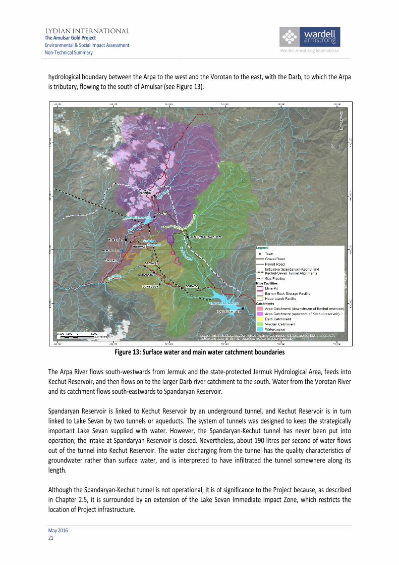
hydrological boundary between the Arpa to the west and the Vorotan to the east, with the Darb, to which the Arpa is tributary, flowing to the south of Amulsar (see Figure 13).
Figure 13: Surface water and main water catchment boundaries
The Arpa River flows south-westwards from Jermuk and the state-protected Jermuk Hydrological Area, feeds into Kechut Reservoir, and then flows on to the larger Darb river catchment to the south. Water from the Vorotan River and its catchment flows south-eastwards to Spandaryan Reservoir. Spandaryan Reservoir is linked to Kechut Reservoir by an underground tunnel, and Kechut Reservoir is in turn linked to Lake Sevan by two tunnels or aqueducts. The system of tunnels was designed to keep the strategically important Lake Sevan supplied with water. However, the Spandaryan-Kechut tunnel has never been put into operation; the intake at Spandaryan Reservoir is closed. Nevertheless, about 190 litres per second of water flows out of the tunnel into Kechut Reservoir. The water discharging from the tunnel has the quality characteristics of groundwater rather than surface water, and is interpreted to have infiltrated the tunnel somewhere along its length. Although the Spandaryan-Kechut tunnel is not operational, it is of significance to the Project because, as described in Chapter 2.5, it is surrounded by an extension of the Lake Sevan Immediate Impact Zone, which restricts the location of Project infrastructure.

The Amulsar Gold Project Environmental & Social Impact Assessment Non-Technical Summary
May 2016 22
In terms of water quality, the Arpa River exceeds legislated Armenian maximum allowable concentrations (MAC) of several metals, including cobalt, iron, lithium, manganese, molybdenum and sodium. Water in the Vorotan River exceeds the Armenian MAC for cobalt, iron, lithium and manganese. Some surface water flowing in streams from Amulsar Mountain to the Vorotan and Darb Rivers exhibits naturally acidic conditions (low pH) and elevated metal concentrations, with parameters above MAC including the aforementioned metals plus aluminium, beryllium and copper. This chemistry results from the water coming into contact with the metal-rich ore body beneath Amulsar Mountain. The Darb River tends to be slightly acidic, with some tributaries failing to meet the Armenian MAC for some parameters. During the summer months, when water flow reduces, the water becomes slightly more acidic due to a higher amount of groundwater contributing to the stream flow. Chemical analysis shows low or undetectable levels of organic chemicals that are usually associated with agricultural or other human-generated sources of pollution Within the Project area, the Arpa and Vorotan rivers are used for hydroelectric energy production, irrigation, and for supporting fisheries. Community domestic and municipal water supply is predominantly sourced from springs originating from shallow perched water or from groundwater. Jermuk's water is sourced from four groups of springs, one of which, the Madikenc group, is within the Project area. Kechut is also supplied by the Madikenc springs, which are located approximately 2 km east of the town. Gndevaz, Saravan, Saralanj, Ughedzor and Gorayk are supplied by springs located outside the Project's area of hydraulic influence. Groundwater Groundwater exists beneath the surface in the spaces between soil particles, in sand and gravel deposits, and within small pores or fractures in underlying rock formations. A formation that is capable of producing significant quantities of groundwater is known as an aquifer. Water flow through an aquifer is slower than surface water drainage. Water from an aquifer can reach the surface through springs, rivers, and wetlands, or where the water table rises to the ground surface during heavy precipitation. In the Project area, groundwater is present in several separate groundwater catchments defined by the rivers surrounding Amulsar Mountain. Groundwater feeds the rivers, particularly during the summer, autumn and winter when little rain falls. Surveys of springs throughout the Project area and in Jermuk, and water chemistry analysis (including major and minor ions and isotope testing) show that groundwater found beneath the footprint of the Project does not supply Jermuk's renowned mineral spring waters. Surveys have identified that groundwater is not directly used for drinking water supply (from drilled wells) within the Project area or in nearby towns and villages. During groundwater baseline studies at Amulsar, data were collected with respect to groundwater elevation, spring flows and groundwater and spring quality. This included sampling outflow from the Spandaryan-Kechut tunnel and the Jermuk springs. This information, together with details of climate and the hydraulic properties of the geological units, was used to develop a conceptual hydrogeological model of the Project area. This was in turn used to build a computational groundwater flow model to better understand the groundwater flow system and its interaction with surface water, and to allow the effects of the Project to be investigated.

The Amulsar Gold Project Environmental & Social Impact Assessment Non-Technical Summary
May 2016 23
3.3.2 What are the potential impacts on water resources and water users? Surface water Water will be taken from the Arpa River for use during Project construction and operation. Computer models predict that the flow in the Arpa will be reduced by less than 0.5% during construction and by less than 4% during operation as a result. The water will be taken from a point below (downstream of) the existing fish farm, which therefore will not be affected. Farmers downstream are predicted to be similarly unaffected. Surface water quality is potentially at risk from leaks or spills of oils and chemicals used during construction and Project operations, and from sediment run-off. However, the Project will employ best international industry practice in water management methods, in terms of design, construction and operation. Most importantly, no water used during ore processing operations ('contact water') will be discharged to the environment until it has been treated and confirmed to comply with Armenian MACs. All water pumped from the open pits, seepage and run-off from the BRSF, and drainage from the truck maintenance facility will be captured and used in operations, until year 5 of operations. Thereafter, a proportion of the drainage from the BRSF will be flow into a passive treatment (or wetland) system. The discharge from the treatment system will conform to Armenian Mac’s and discharge to ground and drain towards the Arpa River. The cyanide solution used to leach the ore at the HLF runs in a closed circuit from the heap leach pad to a pregnant solution pond and then to the ADR plant, where the precious metals are removed and the solution is cycled through a conditioning plant and back to the leach pad. Storm water ponds will be available to collect excess run-off in the event of extreme precipitation or snow-melt events. Any run-off water that needs to be discharged will be tested to ensure it complies with Armenian discharge standards prior to release to the environment. As noted in Chapter 2.6.2, some of the barren rock associated with the Amulsar ore body has the potential to be acid-generating when coming into contact with water. The risk of generating acid rock drainage increases wherever fresh bedrock is exposed, and this will apply during construction and operational activities. The chemical reaction between water, sulphide in the exposed rock, and oxygen in the air creates acidity. This acidity lowers the pH of the water and changes the mobility of metals. Many toxic metals, such as arsenic, lead, and zinc, are more soluble at a lower pH. This process occurs naturally on the sides of Amulsar Mountain, especially in the areas where exposed red-coloured bedrock is visible, and it is the reason many streams in the area are slightly acidic. The generation of acid rock drainage will be accelerated by mining activities because sulphide will be exposed in the pit wall and in the barren rock excavated from the pit. Testing of Amulsar barren rock has shown that dissolved metals are not of significant concern, but elevated sulphate and decreased pH are common in Amulsar acid rock drainage. During the post-closure phase of the Project, there is a risk of the generation of acid rock drainage from the BRSF, which could impact surface water if not properly managed, therefore the drainage from the BRSF will continue to flow to the passive treatment system, following closure. Groundwater During mining, groundwater will seep into and collect in the open pits. This will need to be removed to enable mining to continue, and thus there will be changes in the movement of groundwater in the Amulsar Mountain area. Computer modelling shows that these changes in groundwater flows may cause some springs high on Amulsar to dry up during the late summer or winter months. Modelling suggests that no springs will be lost entirely, and the areas where groundwater feeds springs surrounding the mountain will not be affected.

The Amulsar Gold Project Environmental & Social Impact Assessment Non-Technical Summary
May 2016 24
The nitrogen compounds used in blasting activities have the potential to contaminate water in the open pits. It is likely that these compounds will infiltrate into the groundwater, but it is predicted through modelling that the compounds will attenuate in their passage through the subsurface and will not create a significant impact to water users. An increase in nitrate concentrations is likely to occur for a period following mine operation in high-elevation, perennial, groundwater-fed springs in close proximity to the mine pits. Nitrate in groundwater and surface water is common in agricultural areas where nitrate fertilizer is applied. Acid rock drainage seeping into the ground from the pit could also impact groundwater quality. This could affect springs near to the pits, and groundwater which supports annual flow in rivers. It is important to note that acid rock drainage is naturally occurring in many springs and seeps on Amulsar Mountain. The possible changes in the quality of groundwater discharging as springs have been assessed through technical studies using computer models, which have found that small changes in groundwater quality will probably occur during low-flow conditions in late summer, autumn, and winter close to the mine pits, but the associated changes to surface water quality will be too small to measure. During the operational phase, water infiltrating into the BRSF will have poor quality because of contact with acid-generating waste materials, and nitrogen from blasting residue. This water may change groundwater quality to the north-west of the facility as it flows towards the Arpa River. Approximately 160 million tonnes of barren rock will be placed in the facility over six years, and because of this rapid placement rate the natural water absorption of the rock will limit infiltration through the facility. In addition, during operations perimeter diversion ditches will be in place to direct run-off water around the BRSF and reduce the potential for water to come into contact with the barren rock in the facility. For the seepage that does occur, assessment shows that flow of groundwater from the BRSF to the Arpa River would take more than 100 years. Many constituents present in water in the BRSF would travel much more slowly than this due to physical and chemical processes within the subsurface, taking thousands of years to travel from the BRSF to the Arpa. Small changes in groundwater quality may ultimately occur, but these changes will not result in any change in surface water quality. The direction of flow of groundwater from the BRSF is such that it will not affect water quality in the Madikenc springs which are used for domestic water supply to Kechut and Jermuk. The quantity of water predicted to seep into the BRSF following closure is small because specially designed cover materials will be placed to limit water infiltration Pregnant solution could potentially leak from the base of the HLF if the liner is damaged. The possible impact on groundwater and surface water has been assessed using computer models. Calculations show that small changes to groundwater quality could occur, but these would not result in any measurable change in surface water quality. 3.3.3 What will be done to manage or control impacts? As outlined in Chapter 2 and above, a priority of Project design has been to ensure that the Project does not significantly impact water resources. An extensive programme of water monitoring will be continued throughout all phases of the mine life. This will include monitoring at groundwater observation wells installed specifically to detect water quality impacts down-gradient of the open pits, BRSF and HLF. The monitoring programme will be designed to verify the mitigation measures outlined below, and will also identify any unforeseen impacts, allowing additional actions to be taken, if required. Mine infrastructure will be designed to direct run-off water around the facilities. Water that falls directly onto the facilities will be contained and used as process water:
The Amulsar Gold Project Environmental & Social Impact Assessment Non-Technical Summary
May 2016 25
• The HLF will be lined (a leak detection survey will be completed before the facility starts to operate) and will be operated on a no-discharge basis;
• A basal drain overlying compacted soils in the BRSF will collect water percolating through the facility and convey it for use at the HLF; and
• Pit dewatering will also be undertaken on a no-discharge basis, if water quality does not meet discharge limits.
All process water will be treated and recirculated through the HLF. Sufficient storage capability will be available in the event of extreme rain or snow-melt events. Storage ponds will be double-geo-synthetic lined with leak collection and recovery systems installed between the layers. Any water collected on site will only be discharged to the local environment after being treated in sediment ponds and tested to ensure it conforms to discharge standards. Chemicals and fuels will be handled according to best international mining industry practice. Fuels and liquid chemicals will be stored in areas with secondary containment equal to at least 110% of the storage tank capacity. Vehicles transporting chemicals and fuels will be well maintained and checked for leaks. Spillage kits will be available in all appropriate areas. Detailed procedures to handle chemicals and fuels will be incorporated into all relevant management plans. Lydian will adhere to the International Cyanide Management Code, which will ensure the safe transport, handling and use of cyanide at Amulsar. During closure, specially designed soil cover systems will be placed over the BRSF, HLF and Tigranes-Artavadzes pit to minimise infiltration. Any acid rock drainage seeping from the BRSF post-closure will be routed to the water treatment system which will be maintained at the HLF. At the HLF, rinsing will continue until residual cyanide is destroyed. The spent ore heap will potentially continue to produce poor quality seepage post-closure, but this impact will be limited to elevated sulphate (a natural salt) or nitrate (the HLF will not produce acid rock drainage). Due to these residual water quality issues during the rinsing period of the HLF, water will be treated through the ADR facility water processing plant. After the pad has drained down to approximately 2 litres per second of discharge, water leaving the HLF will be switched to a second passive treatment (wetland) system, which will remain in place until discharge water quality meets Armenian surface water discharge standards. 3.3.4 What risks and impacts will remain? On mine closure, pumping of water from the pits will stop. Modelling shows that water will accumulate within backfill in the Erato pit base after closure, and cause a localised increase in groundwater levels surrounding this pit. Part of the Tigranes-Artavazdes pit will remain open after closure, but no permanent water body is expected to form in this pit. Monitoring will be used to update the hydrogeological model and validate the results of modelling throughout operations, and predictions will be updated based on results. The updated predictions will be used to improve mitigation measures for any post-closure residual impacts, if necessary. The flow paths of some mountain streams in the vicinity of the HLF and the BRSF will be permanently altered, but the impact is not predicted to be significant. Major water courses will not be altered. Barren rock placed in the BRSF and the Tigranes-Artavazdes pit will continue to influence water infiltrating in these areas after closure, although infiltration will be minimised by the presence of covers and there are not expected to

The Amulsar Gold Project Environmental & Social Impact Assessment Non-Technical Summary
May 2016 26
be significant residual impacts on water resources. Surface water run-off quality from both the BRSF and HLF will be comparable to the current baseline after closure. 3.4 Biodiversity and ecosystems The baseline studies undertaken for the ESIA included species and habitats that are important for national or international conservation efforts, and those that are valued locally. 3.4.1 Important wildlife and habitats in the Project area The Project area is characterised by large areas of relatively intact natural habitat, occasionally modified by grazing, and with only relatively small areas of agriculture and urbanisation. There are extensive areas of meadow vegetation within the Project area that are rich examples of 'natural habitat' as defined by international standards including those of the IFC and EBRD, and which warrant special attention. A rare alpine plant, Potentilla porphyrantha, is found on Amulsar Mountain (Figure 14). It is listed in the Armenian Red Book (which aims to identify threatened plant and animal species) with a designation of 'Critically Endangered'. It is found at only five other locations in the world, with two of these being in Armenia. It grows on Amulsar Mountain in rocky areas within the footprint of the open pits and the connecting haul roads. Its international status has yet to be assessed by the International Union for the Conservation of Nature (IUCN), but evaluation by expert botanists has suggested that the species is likely to be classified as 'Endangered' at the global level. Amulsar Mountain is considered to contain 'critical habitat' for this species; this is an internationally recognised designation reserved for habitats which are of the highest priority for conservation. Brown Bears (Figure 15) feed and roam in areas that could be affected by the Project. Brown Bear is listed as 'Vulnerable' in the Armenian Red Book, and it is a protected species under the European Union (EU) Habitats Directive. According to EBRD requirements the Project area is considered to contain 'critical habitat' for Brown Bear. Several of the bird species that are listed in the Armenian Red Book breed in the Project area, and it is also important for resident and migrating raptors, or birds of prey. In spring and autumn, large numbers of birds stop on Amulsar Mountain and in the Vorotan Valley to rest and feed. The Red Book species present include the Egyptian Vulture (Figure 16), listed as 'Endangered' by the IUCN. One pair breeds in the Arpa Gorge, near to the proposed location of some of the Project infrastructure including the HLF.

The Amulsar Gold Project Environmental & Social Impact Assessment Non-Technical Summary
May 2016 27
Figure 14: Example of a Potentilla porphyrantha plant
The internationally recognised Gorayk and Jermuk Important Bird Areas (IBA) border the Project area to the south-east and north-west, respectively. IBAs are regions designated by Birdlife International as being important habitat for the conservation of birds. The main designated species for Gorayk IBA is Lesser Kestrel, which has its only breeding colony in Armenia near Gorayk Village. Both IBAs are also designated for Egyptian Vulture. Several other species that are listed in the Armenian Red Book have been found in the Project area, including two species of viper, two species of beetle, a butterfly species, at least 14 species of bird and one mammal species. There are no rare fish species within the Project area. However, the importance of maintaining fish stocks is recognised. These have been declining due to hydropower plant construction and over-fishing.
Figure 15: Brown bear on Amulsar Mountain

The Amulsar Gold Project Environmental & Social Impact Assessment Non-Technical Summary
May 2016 28
Figure 16 Egyptian vulture
3.4.2 What are the potential impacts on wildlife and habitats? Construction, operation and closure activities will affect wildlife and habitats in the Project area as a result of land use change, disturbance, social changes, and other environmental changes that affect a wider area. Species will lose some habitat completely, and some remaining habitat will be reduced in quality as a result of the Project. Constructing Project infrastructure will require removal and loss of natural vegetation, and will generate dust and noise which can disturb species. Large machinery used for operational activities will generate noise and potentially cause disturbance to wildlife 24 hours a day. Some animals may migrate away from the area as a result. Lighting will be required during the night, and this will potentially disturb animal behaviour, especially of those species active at night, early dawn or dusk. The presence of an increased number of workers, and changes in how local people and herders use the land, is also likely to scare animals away. Placement of fences, conveyor lines and roads creates barriers in the landscape. Barriers like these could block the natural movements of land animals through their habitats. Accidental pollution of air, water, and soil, through unintended leaks or uncontrolled emissions, could degrade the environment and make it unsuitable for animals and plants. 3.4.3 What will be done to manage or control impacts? Measures to manage impacts on biodiversity and ecosystems have been designed according to the principles of first trying to avoid impacts altogether, then trying to reduce their size or severity, and then making best efforts to restore any damage. If there would still be loss or damage of biodiversity despite these measures, then efforts need to be made to compensate for the loss. Recognising the importance of the 'critical habitat' for Potentilla porphyrantha that is present on Amulsar, Lydian has committed to the establishment of a 'set-aside' to preserve a proportion of the species' population in situ. The set-aside, which may include a portion of the Arshak peak, will not be mined. A set-aside will not only help to preserve a viable population of Potentilla porphyrantha, but will also safeguard other natural vegetation, including

The Amulsar Gold Project Environmental & Social Impact Assessment Non-Technical Summary
May 2016 29
potential breeding and hibernating habitat for Brown Bear, and habitat for alpine birds. The final size of the Arshak set-aside is not yet determined. A number of general good-practice measures have been incorporated into the Project design with the aim of minimising impacts on habitats and species. These include minimisation of the Project footprint; use of downward-directed lighting; controlling speeds on roads to minimise dust and prevent injury to animals; and covering waste storage facilities and ponds containing potentially harmful solutions to prevent animal exposure. Some design changes that are advantageous to biodiversity have been implemented: for example, the original location of the HLF was moved to a position outside Gorayk IBA; and the line of the conveyor was adjusted to avoid breeding bird habitat. A wide range of specific actions have been designed to address potential impacts on particular habitats and species as outlined below. Plants As a result of the Project's commitment to international good practice, Lydian aims to deliver an enhancement in the status of Potentilla porphyrantha. This 'net gain' is required to reflect the plant's status as a 'critical habitat' trigger species. Despite the commitment to the set-aside, the Project, and particularly the open pits, will result in the loss of Potentilla porphyrantha plants. Therefore, post-mining restoration efforts will be required to replace - and increase - the plant population. Under permit from the Government of Armenia, plants from within the proposed open-pits footprint have already been collected and transported to a purpose-constructed research facility at Sevan Botanic Garden, where experiments will be undertaken to investigate the best methods for restoring the population of the plant post-mining. The research programme is being undertaken by experts from the Armenian Institute of Botany (part of the National Academy of Sciences), in conjunction with the Cambridge Botanic Garden at the University of Cambridge in the UK. Mammals Brown Bear is a 'critical habitat' trigger species and also requires a 'net gain' approach. A set-aside will preserve bear potential breeding and hibernating habitat, but the area protected may not be large enough to support the existing population. An extensive fieldwork programme was undertaken in 2015 to determine the number of bears at Amulsar and in the wider region, and their movement characteristics. Genetic testing of hair samples is being undertaken, the results, coupled with observations from the 2015 fieldwork, will determine what measures the Project needs to implement to ensure a 'net gain' for the species and report of these finding will be presented during 2016 and incorporated into the species action plan. To manage the barrier effects formed by linear structures, such as the conveyor and access roads, crossing points are to be included. These crossing points will allow animals that use the Project area as part of their hunting and feeding activities to move freely. The effects of the Project will be monitored, including the ability or willingness of animals to use these crossing points. Birds The set-aside will preserve some alpine bird habitat, and care will be taken to ensure that known breeding sites (e.g. the Egyptian Vulture nest in Apra Gorge) will not be affected by Project infrastructure. Birds may be disturbed and lose some feeding area as a result of the Project. However, most species range over wide areas to feed, and are

The Amulsar Gold Project Environmental & Social Impact Assessment Non-Technical Summary
May 2016 30
considered unlikely to be affected significantly. Nevertheless, given the threatened status of some species (like Saker Falcon and Lesser Kestrel), monitoring will continue throughout the Project to indicate any signs of significant impact. The Project is working with the Armenian Society for the Protection of Birds (ASPB) to track movements of Lesser Kestrel in particular. Reptiles and invertebrates Pre-construction checks for reptiles and invertebrates will be carried out, particularly those listed in the Armenian Red Book. Any individuals found will be rescued from working areas as far as possible, and moved to other suitable sites by an appropriately qualified specialist. 3.4.4 What risks and impacts will remain? It is recognised that, despite best efforts to restore the Project site post-mining, it will not be possible to fully restore the natural habitats that currently exist on Amulsar. In addition to the commitment to deliver 'net gains' for the critical-habitat trigger species, Lydian has a general commitment to ensure that the Project results in 'no net loss' of biodiversity. Therefore, as a precautionary measure, Lydian has elected to commit to the establishment of a biodiversity 'offset' to compensate for its entire impact on natural habitat. A biodiversity offset is a conservation action undertaken at an off-site location to compensate for the loss of habitat or species due to a development project. Lydian plans for the natural habitat offset to be implemented in conjunction with the already planned establishment of Jermuk National Park. The aim will be to restore an area of habitat within the park boundary (once established) so that its gain in value equals that potentially lost as a result of the Project. Based on the results of preliminary surveys undertaken in 2015, potential exists to improve management of existing sub-alpine meadow, montane meadow and montane meadow steppe vegetation types in the proposed National Park area. These vegetation types are currently unprotected in Armenia’s protected area system, and there are large areas available which could be restored to a better conservation status. Plans are being developed in partnership with the Government of Armenia and conservation organisations, including consultation with Non-Governmental Organisations (NGOs) to make a new National Park a reality. The methods for calculating 'loss' and 'gain' will adhere to internationally recognised standards. In the short term, the Project will result in the loss of Potentilla porphyrantha plants. In the long term, the maintenance of the population in a set-aside, together with the research programme implemented to plan the reintroduction and restoration programme, is designed to ensure that population numbers are higher post-mining. If this should prove not to be achievable, Lydian will investigate options for offsetting any loss. A similar approach will be taken for Brown Bear if it is determined that the Project will result in residual impacts on the species. Given the sensitive nature of biodiversity at Amulsar, extensive discussions have taken place between Lydian, IFC and EBRD, leading to the establishment of a biodiversity action plan towards implementing the company's commitments to 'no net loss' (and, where necessary, 'net gain') of biodiversity. These activities are continuing in 2016, prior to commencement of construction.

The Amulsar Gold Project Environmental & Social Impact Assessment Non-Technical Summary
May 2016 31
3.5 Society: demographics, economics, livelihoods, and land use 3.5.1 Present state of communities Based on 2011 census data, the population in the Project area includes 4,346 in Jermuk, 791 in Gndevaz, 256 in Saravan (including 21 people living in Ughedzor in summer time), 401 in Gorayk, and other regional residents for a total permanent population of around 6,678 people. An additional 58 seasonal herders use the area around Amulsar Mountain during summer time (see Figure 17 for locations of herder camps).
Figure 17: Community land boundaries and seasonal herder camps, with project infrastructure
The Armenian population is ageing, with less than 20% of people under 15 years old (similar to the United Kingdom at 18%, and in contrast to many African countries which average 40%, according to World Bank data). Women constitute a relatively high proportion of the working-age population, with a proportion of men leaving the area in search of work, usually seasonally. The local communities are largely homogenous, with 99% of residents reported as being ethnic Armenians.

The Amulsar Gold Project Environmental & Social Impact Assessment Non-Technical Summary
May 2016 32
Average households have between five and seven members in Gorayk, Gndevaz, and Saravan. Most Jermuk households have three or more members. Often families consist of different generations, and mother and daughter-in-law relationships are extremely important, with the mother-in-law managing the household, assisted by daughters and daughters-in-law. Despite women’s important role in the home, men are considered the head of the household. However, the trend of men leaving the area looking for work elsewhere has increased the number of female-headed households. The economy of Armenia is dominated by agricultural businesses, but mining is becoming increasingly important. Syunik is the richest Marz in Armenia due to mineral production carried out in the Kapan and Meghri Districts. Private sector employers in rural areas are limited, with the main formal employers in the Project area being the water bottling factories of Jermuk, a milk company in Gorayk, Government positions, Lydian’s activities, and seasonal tourism opportunities.
Figure 18: Herder with flock of sheep in the area around Amulsar
Agriculture and herding activities are the mainstay of most livelihoods in the Project area. Two forms of herding are practised: seasonal herding by people from other parts of Armenia who come to the Amulsar area for summer pasture; and daily herding carried out by the rural villages (Figure 18). Both activities are part of a nomadic tradition within Armenia. Agriculture is important in each of the rural villages, with crops varying in each location. Common staple crops include wheat, spelt, barley and potatoes, and rural residents also keep vegetable gardens near their properties. Gndevaz is famous for the production of export-quality apricots grown in community lands (Figure 19), as well as other fruits.

The Amulsar Gold Project Environmental & Social Impact Assessment Non-Technical Summary
May 2016 33
Figure 19: Apricots
Jermuk was designated an Armenian “Tourism Centre” in 2008 and the Government is working towards making Jermuk a year-round spa resort that meets international standards and can attract up to 100,000 annual visitors. However, since 2008 progress has been limited and tourism activity is largely limited to the summer months. 3.5.2 What are the potential impacts on community demographics, economics, and livelihoods? Employment The Project will employ approximately 1300 people during the peak of construction and 657 during the operations phase. A commitment has been made by Lydian to prioritise local employment; however, due to skills requirements, it is anticipated that the majority of construction jobs will go to people from outside the local area. Tt is estimated that about 30 percent of the operational roles will be filled by residents of the local and nearby settlements. The company is committed to operating as an Armenian operation, with no more than five percent of the operational workforce being expatriates. The income earned by mine workers will be considerably higher than current average salaries in the local communities. Increased employment at the mine, and accommodation of workers in Jermuk hotels and apartments, will cause the expansion of restaurant and entertainment facilities in Jermuk, and increased sales of consumer goods and services. People producing agricultural products may find it easier to market their goods, and will be able to use more regular links to Yerevan to reach larger markets. Tourism facilities will probably be used more because of the increased number of wage earners. Economic modelling suggests that up to eleven jobs will be created during operation within the Armenian economy for every operational role on the Amulsar Gold Project. The corresponding multiplier for the construction stage of the project will be around four. Accommodation of workers during the low tourism season is likely to be welcomed by Jermuk's service industry. However, during the high season, there is a risk that Project accommodation could 'crowd out' tourism activities - and this could have a long-term negative effect (i.e. after the mine has closed). Other potential drawbacks associated with the Project's presence and increased employment in the area include a potential shift from traditional ways of earning a living toward mining and industrial work, including a loss of social traditions, wage inflation and increases in some living costs. Additionally, the transition from construction to operations will see a

The Amulsar Gold Project Environmental & Social Impact Assessment Non-Technical Summary
May 2016 34
major retrenchment of workers, and this will occur again upon mine closure. People migrating into the area The development of a project of this scale will be seen as an economic opportunity by many people, potentially attracting people from outside the immediate area in search of work. Given the tradition of young people (males in particular) leaving for work, the development of the Project may encourage these family members to stay in the area, or to return. If new migrants come into the area they will increase the resident population in the towns, and could change the nature of the communities and existing social structures. In-migrants might include families moving into the area if the breadwinner has gained a job with the Project. Traders and small- to medium-sized enterprise owners are likely to arrive, hoping to capture the increased disposable income that people in the area will have as a result of mining-related employment. It is most likely that inward migrants would settle in Jermuk, because of its extra housing capacity, or in Gndevaz because of its proximity to the Project. The capacity of existing services within the affected communities has been assessed to ensure that an increase in population would not put undue pressure on service delivery for the host population. At present, most services are under-used and would benefit from additional demand. The recent upgrading of the Jermuk wastewater treatment plant has addressed what was previously an expansion constraint for the town. The introduction of new people, both workers and in-migrants, to an area can bring with it social challenges. The sudden increase in salaried employment available locally, combined with potential differences between local customs and the customs of people moving into the area, can also cause social impacts. Social issues that have been experienced by similar projects in Armenia and elsewhere in the world include an increase in alcohol consumption, prostitution and related sexually transmitted diseases, and increased crime and violent behaviour. Economics Based upon an expected gold price of $1,250 per troy ounce and an estimate of 2.2 million ounces of gold produced, the Project is anticipated to contribute USD 485 million in revenues to the state budget through taxes (including income tax on salaries and tax on dividends paid, as well as taxes paid during the construction stage) and royalties. Lydian plans to invest USD 426 million in capital and estimates that salaries paid will be more than USD 230 million over the operational life of the Project. This revenue generation is generally considered positive. As there are concerns in many countries about the importance of tracking revenues paid by mining and oil & gas projects to government, and given the public desire for transparency around how non-renewable resource revenues are made, Lydian intends to publish details of its payments to government entities at least annually and will support any government decision to participate in the Extractive Industries Transparency Initiative (EITI). The development of the Project is likely to have an impact on local inflation. This is driven through increased spending power within the local economy, driving up demand and prices over time. Inflationary pressures may influence purchased items within the communities as well as the local housing market. Inflationary effects are likely to particularly impact households who are reliant upon a cash-based economy either through renting or purchasing property or purchasing food items. Lydian will pay local land rent to the communities for the land that the Project occupies. The land rental payments will be made to Gorayk, Gndevaz and Saravan, each receiving between USD 150,000 and 500,000 per annum. The amount of land rental payable to each village will vary, potentially leading to conflict between communities that
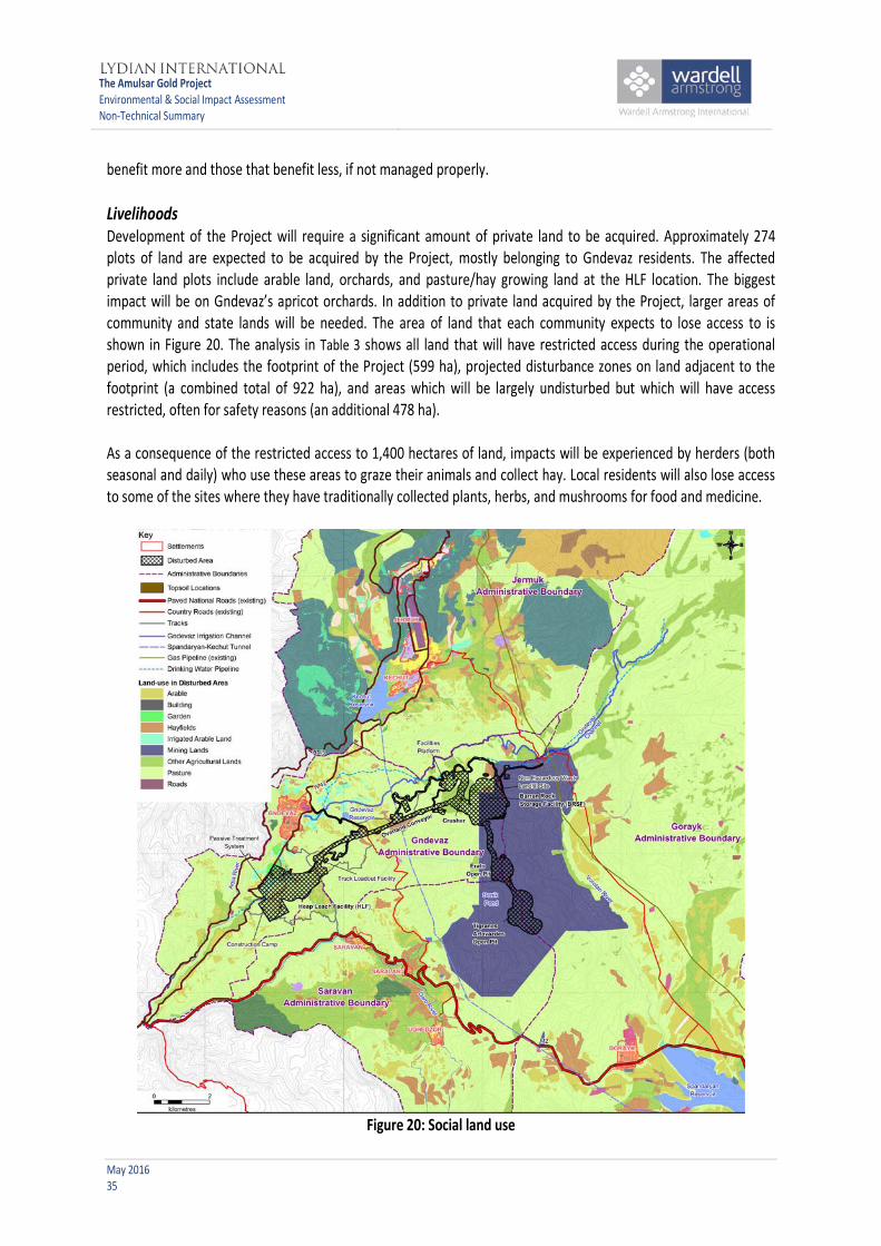
The Amulsar Gold Project Environmental & Social Impact Assessment Non-Technical Summary
May 2016 35
benefit more and those that benefit less, if not managed properly. Livelihoods Development of the Project will require a significant amount of private land to be acquired. Approximately 274 plots of land are expected to be acquired by the Project, mostly belonging to Gndevaz residents. The affected private land plots include arable land, orchards, and pasture/hay growing land at the HLF location. The biggest impact will be on Gndevaz’s apricot orchards. In addition to private land acquired by the Project, larger areas of community and state lands will be needed. The area of land that each community expects to lose access to is shown in Figure 20. The analysis in Table 3 shows all land that will have restricted access during the operational period, which includes the footprint of the Project (599 ha), projected disturbance zones on land adjacent to the footprint (a combined total of 922 ha), and areas which will be largely undisturbed but which will have access restricted, often for safety reasons (an additional 478 ha). As a consequence of the restricted access to 1,400 hectares of land, impacts will be experienced by herders (both seasonal and daily) who use these areas to graze their animals and collect hay. Local residents will also lose access to some of the sites where they have traditionally collected plants, herbs, and mushrooms for food and medicine.
Figure 20: Social land use

The Amulsar Gold Project Environmental & Social Impact Assessment Non-Technical Summary
May 2016 36
Table 3: Project-affected land
Community Total Land Owned
by Community (ha)
Lost or limited Access (ha) Percentage land lost
Gndevaz 6,160 928 15% Saravan 7,788 199 3% Gorayk 21,979 274 1% Total 35,927 1400 3.9%
3.5.3 What will be done to manage or control impacts? The Project has a dedicated social management team which is responsible for managing and mitigating potential social impacts and which engages regularly with affected stakeholders. Affected community members can raise any concerns they may have with the Project and its potential impacts through the community grievance mechanism, as well as during Community Liaison Committee (CLC) meetings, as described in detail in the Stakeholder Engagement Plan (SEP). Lydian is committed to prioritising local employment, other factors being equal. In order to boost local skills levels and better prepare local communities to be eligible for employment opportunities, a training programme will be rolled out in early 2016, offering access to technical training over a fixed period of time. This training programme is being designed to respond to known skills or training gaps of relevance to the Project within the local communities. The goal of the training programme will be to improve the employability of the local community residents, targeting operational roles on the Project. In order to ensure that Project workers' accommodation does not 'crowd out' tourism, the Project has consulted with tourism operators, hotel owners and operators and town administrators to plan for the introduction of construction workers. As part of this engagement process, the Project will continue to communicate the requirements for the ongoing accommodation of project workers. A worker accommodation management plan has considered the alternative options for construction workforce accommodation, which will be based on a combination of workers who live locally, the use of hotel and apartment accommodation in Jermuk and an on-camp to accommodate between 500 and 920 workers. All employees and contractors will be required to agree to the Lydian Code of Conduct which stipulates expectations for behaviour. Failure to comply with the Code would lead to disciplinary measures for employees and contractors. Given the under-use of most services within the local communities at present, it is anticipated that additional population growth will not overwhelm service delivery. This will be closely monitored by the company in co-operation with local government authorities. Other steps that Lydian will take include linking into the local hiring and purchasing policies of the Local Business Initiative. This initiative requires contractors to identify skills held within the local communities before employing workers. Good communication will be maintained with the already established CLCs so that any problems resulting from potential in-migration can be addressed quickly, and with the support of the community. Lydian will continue to publish the amount of royalties and taxes it pays, in addition to reporting on the amount of land tax paid to communities each year. Inflationary pressures will be monitored by the Project and are being managed through efforts to keep salaries in

The Amulsar Gold Project Environmental & Social Impact Assessment Non-Technical Summary
May 2016 37
line with industry norms in Armenia. To help manage the changes in the ways businesses and communities make a living in the area, the Project will continue to support small and medium enterprise programmes to help communities overcome difficulties through training. These programmes will focus on agricultural activities in particular. Land needed for the Project is being managed as a negotiated purchase. Consultation is ongoing with communities to determine the package of compensation land owners and users will receive. Land-for-land compensation will be offered. Monetary compensation for those who prefer it will cover the value of the land and an allowance for any loss of harvest due to the time required to re-establish equivalent crops on a different area of land. These provisions are described in detail in the LALRP addendum published in February 2016 and appended to the ESIA. The Project has been designed to minimise impacts to herders through location of Project facilities in areas outside of those known to be important to herders, where possible. Regardless, herders will lose access to some pasture land, and access to other areas will be restricted. The impacts of these changes are difficult to predict and they will be monitored during Project implementation to determine whether additional mitigation is necessary. While areas currently used for foraging will be lost or subject to restricted access during the mine life, this is not expected to be a significant impact due to the widespread availability of the same items outside the Project area and close to affected communities. When mining concludes, closure and rehabilitation activities will restore access to most of the land previously lost, allowing it to return to previous grazing use. Some land, however, will not be able to be returned to its previous use, due to the restored topography, with slopes that are too steep for agricultural uses. The social effect of the retrenchment associated with the transitions from construction to operations and from operations to mine closure will be managed through effective, early consultation and planning. Retrenchment planning will also be required from Lydian's contractors. 3.5.4 What risks and impacts will remain? Even with mitigation measures in place as described above, significant in-migration could still occur. Lydian will work with local administrators to assist in planning for community expansion. The introduction of non-residential workers and the potential for job-related in-migration to Jermuk could affect the level and type of social problems experienced within the community. This will be monitored and additional mitigations put in place as necessary. The income from land rent should provide positive contribution to local development. The contribution from the Project to the Armenian budget through taxes and royalties is likely to have a positive impact, as will the induced employment impacts across the economy. The effects of directly employing people at the Project are expected to last longer than the life of the Project, as during the Project individuals will develop new skills and the economy will grow larger. These positive effects will be moderated, however, by the negative effects of major retrenchments at transition points in the Project. Efforts to track and monitor purchasing by the mine, and training initiatives, will help with the overall improvement of the economy. Not all sectors of the economy will benefit from the development of the mine. It is likely that the agricultural sector

The Amulsar Gold Project Environmental & Social Impact Assessment Non-Technical Summary
May 2016 38
will be significantly impacted, through a combination of reduced land availability, agricultural workers seeking employment in the mining project, and changes within society which move away from the traditions of agricultural practices. Some access restrictions to Project land will remain after closure. The former open pits and HLF are not likely to be suitable for grazing use due to topography and safety considerations. 3.6 Community health, safety and security 3.6.1 Present health conditions and facilities The communities in the Project area currently have sufficient medical services and hospitals for the number of people resident in the area. There is also a functioning ambulance system in place. Medication availability is limited in public health facilities, and the supply problem is made more challenging because there are few local private pharmacies. All communities studied have access to piped drinking water, but the quality of piped water in Gorayk and Saravan does not meet international drinking water standards. Sewerage systems in rural communities are usually not present. Domestic waste collection is limited and has been supported by the Project since early exploration activities began. In Jermuk, access to drinking water and domestic waste removal is better than in the more rural areas, but there are community concerns in Jermuk and Kechut about the quality of drinking water. The waste water treatment plant in Jermuk has recently been upgraded with a design capacity for 22,000 people, far exceeding its current demand. The major health concerns in Armenia are associated with diseases that are not infectious and are not spread between people. In general, the burden of disease in the study area follows a similar pattern, with cardiovascular disease, cancers and diabetes reported as the most common health concerns. Levels of sexually transmitted infections are low in the area, with the few people known to have contracted such infections having done so while working as migrant labour outside of the Project area. Similarly, while tuberculosis is present in Armenia, the study area has had only a few reported cases. Elevated radon levels exist in the rural areas around the Project, especially in Gorayk. The radon is unrelated to Project activity and is a consequence of the underlying geology. 3.6.2 What are the potential impacts on health, safety, and security? The Project is expected to bring about a number of community health improvements. These include reductions in the incidence of water, sanitation and waste-related diseases through structural improvements made to waste management and improved wellness education related to non-communicable diseases. It is also expected that the Project could result in some community health, safety and security drawbacks. The most significant of these are an increased risk of sexually transmitted diseases, increased number of road traffic accidents, and a new risk of security conflict between the mining company and communities affected by the Project. Accommodation of workers in a closed camp, which is under consideration if deemed necessary, can also present risks associated with communicable diseases, including tuberculosis. The wages and salaries the mine pays will increase the wealth of mine workers. Some of these workers may engage in risky sexual behaviour. The Project’s proposed accommodation of rotational workers in Jermuk could increase

The Amulsar Gold Project Environmental & Social Impact Assessment Non-Technical Summary
May 2016 39
the town’s exposure to this risk. The amount of road traffic travelling to and from the mine site will significantly increase, leading to an increased risk of road traffic accidents and noise. The road infrastructure has sufficient spare capacity to accommodate the increased traffic flow. The Project will be producing doré product, which is a mixture of gold and silver. The value of this product will necessitate an enhanced security presence at the site to prevent losses. A security presence, either using private or public security guards, could create conflict were security services to use force inappropriately. This could occur if tensions between the neighbouring communities and the Project arise, and guards are not properly trained to deal with such a situation. 3.6.3 What will be done to manage or control impacts? Health system impacts The Project will monitor demographic changes in the communities studied and work with local health authorities to determine if available health facilities remain adequate for the needs of the community. The Project will ensure that its health services can adequately cater for the needs of the workforce in terms of occupational health and emergency care. The Project will also look for opportunities to partner with the government, donor agencies or NGOs to improve health care services in the broader area. Sexual health and communicable diseases The Project will manage sexual health issues in a number of ways. There will be direct engagement with the workforce, through policies, codes of conduct, and education programmes that encourage responsible and respectful behaviour in the host communities, and prohibit sexual harassment. An HIV policy has also been developed for the Project. The sexual health and sexually transmitted infection programmes will extend to long-haul truck drivers, with the support of the contractor responsible for goods delivery. All accommodation used or constructed for workers will meet international standards to minimise the risk of communicable disease transmission. Accidents and injuries To deal with the risk of an increased rate of accidents because of mining and associated activities, the Project will develop a community health and safety management plan based on a risk assessment of planned activities. This will include emergency preparedness and response plans for both community related accidents and also for the workplace. Lydian has published the Occupational Health and Safety Policy for the Project and an associated management plan covers all aspects of the health and safety requirements that will be maintained during the construction, operational and closure phases. Measures such as setting and policing speed limits for heavy goods vehicles making deliveries to the site, enforcing roadworthiness standards, and enforcing a drug and alcohol policy, are some of the things the Project will do to help prevent accidents.

The Amulsar Gold Project Environmental & Social Impact Assessment Non-Technical Summary
May 2016 40
Security conflict To deal with the potential for conflict between the communities and the company (including its security officers), Lydian intends to implement the Voluntary Principles on Security and Human Rights (VPSHR), and will report upon this. Additionally, Lydian will provide adequate training of security personnel on core human-rights issues. As part of this commitment, a risk assessment is being undertaken to minimise the security and human rights effects that are created by the Project. Security contracts will be awarded to local companies, where possible, to minimise the risk of creating tension between host communities and security guards. Security guards will all be given effective training and their performance will be carefully monitored. Water/sewerage The company will construct septic toilet facilities across its workplaces and will manage its own domestic waste. 3.6.4 What risks and impacts will remain? Health care benefits achieved during the life of the Project are likely to continue after the Project ends. It is likely that the moderately negative effects of sexual health issues will persist after the Project ends. Despite management measures, traffic accidents remain a possibility as the behaviour of third parties on public roads is beyond Lydian's control. Lydian's adherence to the VPSHR should minimise risks related to security conflicts. It is acknowledged that this is an issue that will need careful monitoring. 3.7 Air quality 3.7.1 Present air quality conditions The activities of major urban and industrial centres typically cause the air quality to become poorer with time, due to emissions from road vehicles and industrial processes. In the rural environment human activities such as intensive agriculture and mining can also cause an effect on air quality, but to a very small degree compared to industrial emissions. There are no major urban or industrial centres near the Project that give rise to significant gaseous and particulate emissions. Some gaseous emissions enter the atmosphere from the settlements surrounding the Project because of vehicle exhausts, domestic heating and fires, and in the local vicinity of the Kechut landfill. Visually, the air quality in the Project area and surroundings is clear and unpolluted, with no visible smog or haze caused by airborne pollution. Occasionally plumes of smoke from domestic fires can be seen; domestic fires are common in all settlements during the cold winter months. The most common emission in the local area is dust or particulate matter. This is released when vehicles travel over paved and unpaved roads, or when wind erodes particles from open storage of loose solid materials, exposed soil surfaces and unpaved roads.

The Amulsar Gold Project Environmental & Social Impact Assessment Non-Technical Summary
May 2016 41
Monitoring has shown that baseline concentrations of two gaseous pollutants SOx and NOx (oxides of sulphur and nitrogen) in the air around the Project site are well below World Health Organisation (WHO) guideline levels. These pollutants are common in urban areas because of high volumes of road traffic, so the low concentrations in the Project area are as expected. 3.7.2 What are the potential impacts on air quality? During construction, dust will be generated from earthworks (including clearing of vegetation and topsoil) and constructing roads, buildings and other infrastructure. During operations, dust emissions will occur when drilling, blasting, loading, hauling, unloading, crushing, transporting and placing ore and barren rock. The main source of dust emitted to the environment will be from the wheels of haul vehicles raising dust from the surfaces of the haul roads. The next most significant source of dust will be the ore crushing plant, where mechanically breaking rocks into smaller particles produces dust that can be subsequently released into the air in the absence of mitigation. Emissions to air from combustion processes, such as mobile equipment diesel engines, blasting, boilers, and the gold recovery plant are likely to include respirable small particulates (PM10, which are less than 10 millionths of a metre in size) which can be a cause of human health issues, and gases such as carbon dioxide (CO2) and NOx. Unpleasant odours could be generated from decomposing domestic waste and from domestic wastewater treatment and disposal. However, these are sufficiently distant from the local communities for this potential Project impact to be non-significant. A dust screening assessment (Figure 21) shows two areas predicted to be affected by nuisance dust, demarcated by a 350 milligrammes per square metre per day (mg/m2/day) and a 133 mg/m2/day contour. These reflect the levels at which different human receptors are expected to perceive dust as being a nuisance, with more sensitive people experiencing an effect at a dust deposition rate of 133 mg/m2/day, and less sensitive receptors only experiencing nuisance at 350 mg/m2/day or greater. The distance from dust emission sources where nuisance effects may be felt varies with wind direction, but the maximum distance from source at which nuisance dust could affect human receptors is estimated to be 850m. The livestock farm south-east of Gndevaz lies beyond the zone of potential nuisance (133 mg/m2/day), but it does lie within 850m of the dust sources at the overland conveyor discharge and truck load-out facility. All other residential and community receptors are beyond this distance from the Project, and the potential for impacts of dust deposition on these receptors is therefore considered to be low for both the construction and operational phases. Soils, vegetation and grazing land adjacent to the mine could be influenced by deposition of dust particles from surface operations. Most (82%) of the dust deposition that could alter the character of the grazing land will be deposited within 100m of the dust sources. With respect to respirable PM10 dust, the modelling suggests that in worst-case conditions, over 95% of the dust emitted from the Project will be deposited within 1km of the source, with over 90% deposited within 500m of the source. The nearest residential communities are located approximately 1km from the nearest source and therefore the fine particulate levels will have reduced to a very low proportion (less than 1% of emitted levels). The concentrations will not exceed the Project compliance criteria, which are based on WHO standards. Gaseous emissions from vehicle movements will mostly take place along the open pit haul roads and for a short section to the HLF. The open pit haul roads are about 4.5 km from the nearest settlement (Ughedzor, not

The Amulsar Gold Project Environmental & Social Impact Assessment Non-Technical Summary
May 2016 42
permanently occupied) and the haul road to the HLF is at a distance greater than 1km from the edge of Gndevaz. Gaseous emissions disperse within approximately 200 m of the source and will have no measurable effect on air quality within the surrounding communities.
Figure 21: Estimated total dust deposition from the mining activities
3.7.3 What will be done to manage or control impacts? The Project has been designed to incorporate several techniques to manage fugitive dust emissions from the site. The crushing plant will be enclosed in buildings, thus containing the dust generated by the crushers. Crushed rock will be conveyed in a covered conveyor, and water sprays will be used at the points where material is transferred from one conveyor belt to another. Fine sprays of water will trap fugitive dust and prevent it from dispersing. Haul roads and other access roads that have the potential to generate dust emissions will be sprayed with water or

The Amulsar Gold Project Environmental & Social Impact Assessment Non-Technical Summary
May 2016 43
treated with non-hazardous chemicals to limit dust generation. Other dust suppression measures include controlling vehicle speeds on mine roads, keeping the heap leach and BRSF moist, and the construction of vegetative barriers. To control gas emissions from vehicles and other combustion sources, equipment will be regularly maintained, and built-in emission control equipment will be kept in good working order. A primary monitoring station will be located between Gndevaz and the HLF area, using the apartment that has been acquired by the Project in order to establish this monitoring point. The monitoring station will provide for the continuous measurement of particulate concentration and monthly data for dust and vehicle exhaust gases. 3.7.4 What risks and impacts will remain? After applying all management and control measures, no negative impacts on air quality are expected to remain in both the short and long term. 3.8 Greenhouse gas emissions and climate change There is scientific consensus that climate change is partially caused by Greenhouse Gas (GHG) emissions from human activities. New industrial activities that release GHGs, including this Project, add to the emissions and so contribute towards global climate change. There are a number of gases that are known to influence climate change. The most well-known is CO2, but other gases include methane, nitrous oxide, and hydro fluorocarbons (used as a refrigerant). Some of these other gases are stronger GHGs than others and this is accounted for by expressing all GHG emissions as though they were CO2. This is known as calculating their CO2 equivalents (CO2e). Climatic conditions within the area of the Project site are described as Warm Summer Continental. Such a climate has significant precipitation (rain and snow) throughout the year and temperatures averaging over 10°C for four months of the year (June to September). The climate has a large difference between winter and summer temperatures because of the continental location. Variation of altitude plays a significant role within the Project area. 3.8.1 What are the potential impacts of the Project on the climate? The main source of GHG emissions from the Project includes burning fossil fuels in construction and mining equipment and transportation vehicles for employees; land use during construction (removing vegetation that would have otherwise captured carbon emissions); explosives; natural gas for heating administrative buildings; and use of non-renewable electricity generated off site. The Project could generate a maximum annual output during the operational phase of approximately 92,200 tonnes of CO2e. The cumulative total GHG emissions for the Project have been estimated at 965,900 metric tonnes.. These GHGs will contribute to global climate change. Expressing the significance of the impact that will result directly from Project GHG emissions is difficult, because on its own the Project's effect will be negligible; it becomes significant when combined with all other human activities across the world.

The Amulsar Gold Project Environmental & Social Impact Assessment Non-Technical Summary
May 2016 44
3.8.2 What will be done to manage or control impacts? Anticipated GHG emissions have been reduced through engineering design measures. Some of the design measures to reduce emissions include keeping land clearance areas for construction to a minimum; using a conveyor generating electricity instead of haul trucks to transport crushed ore; shortening haul roads; insulating buildings for energy conservation; using modern energy-efficient mining equipment; and using electricity for heating instead of natural gas. It is also notable that compared with other processing technologies, heap leach techniques use less energy and have a smaller potential climate change impact. The potential for use of renewable energy options, such as wind, solar power, or use of biodiesel in non-road equipment, has been considered but is not considered to be suitable currently. However, Lydian will continue to monitor any viable options throughout the lifecycle of the Project. Mine design will aim to minimise handling the same material (such as ore or barren rock) more than once, because this would use more fuel and thus release more GHGs per tonne of ore mined. Smart scheduling will be focused on excavation and haulage activities as these, together with crushing, are the main sources of GHG emissions. 3.8.3 What risks and impacts will remain? Project efforts to reduce GHG emissions will not make a significant difference to global climate change that is already progressing. The changing climate has the potential to affect the Project. Air temperatures in Armenia have increased by 0.85°C since 1935, and rainfall and snowfall has reduced by 6% over the same time period. Climate change predictions show that by 2030 the Project area can expect up to a 1°C increase in annual temperature. Summers are expected to have higher temperatures and up to 7% less annual precipitation, which would also reduce water flow to rivers by 7%. 3.9 Noise and vibration Noise and vibration are measures of what can be heard and felt from industrial processes. The assessment considers how local communities will experience these impacts. 3.9.1 Present sources of noise and vibration Existing sources of noise in the communities surrounding the Project area are few. Industrial sources of noise are two water bottling factories, a milk factory and a petrol station. All of these sources are in Jermuk. Other noise sources in the area are from traffic along the M-2 and H-42, and agricultural activity. 3.9.2 What are the potential noise impacts? Construction activities that will generate noise include clearing soil and rock (including by blasting), preparing foundations, operation of concrete and aggregate batching plants, and heavy vehicle operation. During operation of the mine, noise will result from drilling and blasting, movement of haul trucks transporting ore and barren rock along the haul roads, the action of the crushers, and operation of the conveyor. Noise from vehicle movements and processing plant equipment is expected 24 hours per day during the construction and operational phase, except during planned shutdowns for maintenance or as a result of bad weather conditions. Noise and vibrations as a result of blasting will occur daily (Monday – Saturday). There will be instantaneous noise
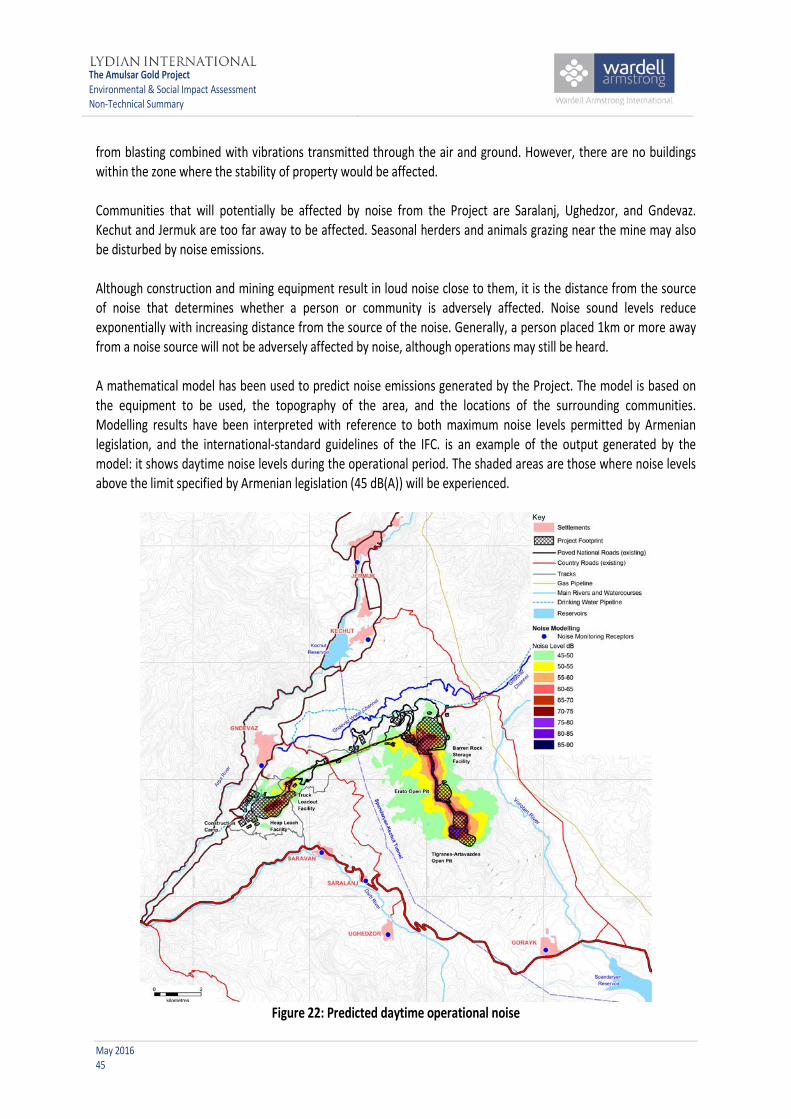
The Amulsar Gold Project Environmental & Social Impact Assessment Non-Technical Summary
May 2016 45
from blasting combined with vibrations transmitted through the air and ground. However, there are no buildings within the zone where the stability of property would be affected. Communities that will potentially be affected by noise from the Project are Saralanj, Ughedzor, and Gndevaz. Kechut and Jermuk are too far away to be affected. Seasonal herders and animals grazing near the mine may also be disturbed by noise emissions. Although construction and mining equipment result in loud noise close to them, it is the distance from the source of noise that determines whether a person or community is adversely affected. Noise sound levels reduce exponentially with increasing distance from the source of the noise. Generally, a person placed 1km or more away from a noise source will not be adversely affected by noise, although operations may still be heard. A mathematical model has been used to predict noise emissions generated by the Project. The model is based on the equipment to be used, the topography of the area, and the locations of the surrounding communities. Modelling results have been interpreted with reference to both maximum noise levels permitted by Armenian legislation, and the international-standard guidelines of the IFC. is an example of the output generated by the model: it shows daytime noise levels during the operational period. The shaded areas are those where noise levels above the limit specified by Armenian legislation (45 dB(A)) will be experienced.
Figure 22: Predicted daytime operational noise

The Amulsar Gold Project Environmental & Social Impact Assessment Non-Technical Summary
May 2016 46
Modelling for conditions during construction, demonstrates that noise from the Project will not result in any increase over existing background levels during daytime at any of the local communities surrounding the Project. At night time noise levels at Gndevaz will increase by up to 1 dB(A) above background levels and, although this may be noticeable, it will not cause a nuisance. Modelling for conditions during the operational phase in daytime hours suggests that although the maximum noise levels permitted by Armenian legislation will not be exceeded, noise levels in Gndevaz will increase by up to 2 dB(A). This increase will be noticeable but, as interpreted by reference to the IFC guidelines, will not be sufficient to cause nuisance. At night-time (during operations only), noise levels are predicted to increase by up to 2 dB(A) in Gndevaz and by 1dB in Saralanj, Saravan and Kechut. Again, these increases will be noticeable but are not expected to cause nuisance. No increase in noise levels is predicted in the other communities. Herders working closer to the mining operations may experience higher levels of noise. Modelling suggests that noise from blasting will be audible from all of the local communities. The blasting will only take place during the day, and will be an instantaneous (less than one second) noise. Vibration effects will not be perceptible in the communities.
3.9.3 What will be done to manage or control impacts? The crusher building will be enclosed and the conveyor will be covered to reduce noise. Noise barriers and baffles or enclosures will be used around noisy fixed equipment where required. Haul vehicles and other mobile equipment will be modern and well maintained. Particularly noisy activities will be scheduled during the daytime whenever possible. The blasting schedule will be communicated to neighbouring communities and stakeholders, so that affected people will know when to expect instantaneous air blast. Blasts will be designed to minimise vibrations transmitted through the air and ground. Noise and vibration monitoring will continue on a regular basis to ensure that noise and vibration levels remain within international and Armenian standards. In addition, a primary monitoring station will be located between Gndevaz and the HLF area, using the apartment that has been acquired by the Project in order to establish this monitoring point (see Section 3.7.3). The monitoring station will provide for the ongoing monitoring of noise, air overpressure and ground vibration from blasting. A baseline survey of building cracks is to be undertaken in 2016 to assess the situation pre-mining. 3.9.4 What risks and impacts will remain? No noise-related impacts on communities are likely to persist after management measures have been applied. Noise could disturb herders, wildlife and grazing livestock, which may tend to move away from the noise source, although they may return post-mining when noise levels return to those identified in the baseline. 3.10 Transport services and Infrastructure As there are no rail or canal links that can be used for the Project, this assessment considers road usage. It deals with the amount of traffic that travels on the roads, the type of traffic (whether heavy or light vehicles), the

The Amulsar Gold Project Environmental & Social Impact Assessment Non-Technical Summary
May 2016 47
condition of the roads, and how well maintained they are. 3.10.1 Present traffic network and infrastructure Armenia has a north-south road, the M-2, that runs from Georgia, through Armenia via Yerevan, passing close to the Project and linking to Iran, and which is the main road route to the Project from Yerevan. The road has a hard surface, and the condition is considered to be generally fair. This road will be the main access route for transporting equipment and supplies from outside Armenia to the Project. On the main road junctions in the Project area where traffic was monitored, the number of road vehicles was estimated to be less than 15% of the total amount of traffic that the roads could handle. 3.10.2 What are the potential impacts on transport? The construction period of the Project will generate traffic through bringing construction materials and equipment to the Project area, and transporting the construction workforce to and from the Project. The main access points to the mine are labelled Access A on Figure 23; which has a junction on the H-42, to the south of Gndevaz. A second, minor access point will be developed as a junction off the H-42 north of Junction A and labelled Access C on Figure 23). Access B, also off the H-42 (shown on Figure 23), provides access to the truck load out and conveyor. The existing access at Kechut will be used during the construction phase only. These junctions on the H-42 will result in an increase in the traffic flows during construction, operation and closure phases of the Project. Modelling of the increase in traffic flows showed that some of the roads will experience a significant increase in traffic flow, but that even in worst-case scenarios the roads will still have plenty of capacity for additional vehicles during the construction phase. Heavy vehicle deliveries are expected during the operational phase of the Project. Deliveries will be required for equipment spare parts, miscellaneous materials, building supplies and fuel. The Project will also need process materials, chemicals and reagents for processing operations. Maintenance and service vehicles can also be expected to access the Amulsar site at regular intervals during the operational phase. Modelling indicates that the volume of traffic flowing through each traffic junction will not require any modification to the road alignment, other than the junction layouts. More traffic is expected during the construction phase than during the operational phase, with the least amount of traffic during the closure phase. 3.10.3 What will be done to manage or control impacts? Management of Project-related traffic will be implemented from the start of the construction phase. The traffic management plan will provide health and safety measures needed to ensure that heavy goods vehicles transporting hazardous chemicals are appropriately managed. Lydian will have specific requirements for employees and contractors driving within the area in relation to speed, courtesy to other road users and behaviour with residents. 3.10.4 What risks and impacts will remain? During the construction phase some large loads will be transported to the Project, and these could interrupt normal

The Amulsar Gold Project Environmental & Social Impact Assessment Non-Technical Summary
May 2016 48
traffic flow. However, these disruptions will only last for a relatively short period of time (a number of hours along any particular stretch of road). Transport requirements for staff during the operational phase are reduced by using shuttle buses to and from the mine. Impacts that will remain during the operational phase will be the regular transportation of hazardous chemicals, including deliveries of cyanide by convoy. The delivery of hazardous chemicals will require careful monitoring and will conform to international health and safety standards, including the International Cyanide Management Code.
Figure 23: Access junctions to the Project
3.11 Archaeology and cultural heritage Armenia’s archaeological and historical wealth can be seen in the region where the Project is found. It has traces of local prehistoric cultures and later foreign influences. Armenia’s long history includes periods of independence and periods when the country was controlled by other powers. Its strategic location between two continents has resulted in Armenia being invaded many times, including occupations by the Assyrians, Greeks, Romans,

The Amulsar Gold Project Environmental & Social Impact Assessment Non-Technical Summary
May 2016 49
Byzantines, Arabs, Mongols, Persians, Ottoman Turks and Russians. 3.11.1 Presence of archaeological artefacts and cultural heritage Fieldwork in the Amulsar Project area has identified a total of 487 potential cultural heritage sites, which have been classified as possible archaeological sites, confirmed archaeological sites, or living heritage sites. Some of the confirmed archaeological sites include ruined structures visible and partially preserved on the surface. The sites include: • Earth and stone mounds of various sizes that may have been tombs from various periods, some
potentially dating to the Bronze Age (3,400-1,500 BC) (see Figure 24); • Cemeteries identified by stone markers, some of them worked and/or inscribed, and mounded earth
dated to the Middle Ages; • Potential settlement sites dated to the Late Middle Ages indicated by ruined architecture on the surface; • Prehistoric campsites and activity areas of pre-Bronze Age peoples, indicated by chipped and ground
stone tools; and • Living heritage sites including 20th century seasonal shepherd’s camps with possible burials/cemeteries. To date, 138 of the 479 potential cultural heritage sites have been assessed for their sensitivity, resulting in the identification of: • Four very high-sensitivity sites; • 27 high-sensitivity sites; • 32 medium- sensitivity sites; • 22 low- sensitivity sites; and • 53 negligible-sensitivity sites. Most of the identified sites are located in the Vorotan River valley, and most are outside the Project-affected area. The site assessments have not identified any critical cultural heritage sites within the current Project-affected area.

The Amulsar Gold Project Environmental & Social Impact Assessment Non-Technical Summary
May 2016 50
Figure 24: Possible bronze age tomb found in the Vorotan River valley, outside the Project-affected area
3.11.2 What are the potential impacts on artefacts and heritage? Any construction, operational, or mine closure activities that involve digging up land, disturbing land, or dumping stockpiles of material onto land have the potential to damage or destroy previously unidentified archaeological artefacts. Activities will include grading, excavation and other ground-disturbing site preparation activities. Based on current knowledge, the Project activities will substantially impact 81 archaeological sites, although none of the known artefacts are considered by either national or international cultural heritage experts to be of high importance to archaeology. It is possible that important artefacts could be discovered during construction and operational activities at the Project, and this would have the potential of causing significant losses to the scientific and cultural value of the sites. 3.11.3 What will be done to manage or control impacts? The cultural heritage resource impacts will be mitigated through avoidance and management of known resources, including: • Avoiding and marking known cultural heritage sites; • Additional surface reconnaissance of un-surveyed Project footprint and sites of un-assessed cultural
heritage sensitivity; • Archaeological evaluation through surface reconnaissance and archaeological excavations of sites inside
the proposed Project footprint and sites within 50 m of the proposed footprint;

The Amulsar Gold Project Environmental & Social Impact Assessment Non-Technical Summary
May 2016 51
• Based on the results of the archaeological evaluations, excavating sites of medium to very high importance that cannot be avoided through Project redesign;
• Implementing a Chance Finds Procedure; • Providing training for Project staff on the importance of cultural heritage, details of the Chance Finds
Procedure, and identifying cultural heritage sites; and • Consulting with stakeholders, including the Ministry of Culture of the Republic of Armenia. During construction and operations new artefacts may also be discovered. Lydian will train all employees to follow the Chance Finds Procedure that will prepare employees to be aware of potential cultural artefacts, how to temporarily stop work when items are found, and the ways to work with government and experts if finds are scientifically important. 3.11.4 What risks and impacts will remain? Constructing the Amulsar mine will result in impacts to known and potential cultural heritage sites. However, by implementing the mitigation measures described above, impacts to cultural heritage resources will be significantly reduced. Implementing these mitigation measures, which follow applicable national standards and international best practice, should also result in positive impacts to Armenian cultural heritage. Project-related archaeological discoveries and investigations in the Amulsar area would contribute to scientific and cultural understanding of Armenia’s past. 3.12 Ecosystem services Ecosystem services are the benefits that people get from the natural environment, often without having to pay for them. They include timber, herbs, fish and fresh water, but also natural processes such as pollination of fruit trees or natural vegetation that prevents soil erosion. Ecosystem services also include enjoyment of the natural environment for walking, relaxing or the view. The Project will affect the supply of some services or the ability of people to continue using them as they do now. 3.12.1 Present condition of ecosystem services The Project area provides many services, including meat and milk from grazing livestock. The pasture land in the area is considered to be highly productive because of its good soil quality and plentiful water supply. Many people value their traditional ways of life, including seasonal and daily herding of animals. People, particularly seasonal herders, make use of dried dung as a fuel. The Project area also provides hay, freshwater, and herbs for natural medicine and remedies. Honey from wild flowers, wild and farmed fish, wild fruit, nuts, and mushrooms are all collected by people in the area. The river catchments around the Project play a part in controlling water run-off and groundwater levels. Vegetation already growing within the Project area prevents soil erosion from taking place, while existing wetlands help to purify water running through the Vorotan catchment area. Local communities have strong traditional links with the land, and want to maintain the full range of ecosystem services that they use. They appreciate the landscape and biodiversity in the area and are aware of its value, for example the role of wolves and foxes in controlling numbers of rodents. The Project area supports a large number of species, including some that are nationally and globally threatened.

The Amulsar Gold Project Environmental & Social Impact Assessment Non-Technical Summary
May 2016 52
3.12.2 What are the potential impacts on ecosystem services? The Project will occupy land which will no longer be available for producing milk, milk products and meat from livestock. The quality of land that will not be occupied may deteriorate (or be perceived to deteriorate) because of pollution from dust falling on the land, from chemicals getting into soil or water, from soil erosion or from changes in the flow of water over the land surface. As well as affecting grazing land, this may affect the supply and quality of wild herbs and mushrooms, fruit and nuts. Extensive clearing of vegetation for construction and stockpiling soil could lead to soil erosion and sediment loading in streams. The Project will also restrict access to land; for example, the presence of roads and fences may make it difficult to follow traditional grazing patterns. Traditional ways of life linked with daily herding from villages or seasonal herding in the Vorotan Valley could change because of the influence of the Project. The landscape will change and this may affect people’s sense of belonging and their relationship with their environment. 3.12.3 What will be done to manage or control impacts? Impacts on grazing undertaken by seasonal herders will largely be avoided, but there could be some effects from construction traffic and these will be monitored. To maintain access for daily grazing from Gndevaz, crossing points will be provided for the conveyor and associated roads. The effectiveness of these crossings and the ability of people to follow their traditional grazing rotation from the village will be monitored. Environmental management measures should minimise impacts of dust and pollution on herbs, mushrooms and other foods harvested from the wild. Selected sampling will be undertaken for monitoring purposes, and follow-up meetings held in Gndevaz to review the quality and supplies of wild foods and the ability of people to continue collecting them. Changes in traditional ways of life and people’s sense of place and enjoyment of the landscape are difficult to manage. The Project is making efforts to minimise visual impacts through screening and is working with local communities to ensure that their livelihoods will be maintained. 3.12.4 What risks and impacts will remain? Some grazing and cropland will be permanently lost. It is likely that some cultural aspects of the traditional herding life will be altered. Any impacts on livelihoods will, however, be addressed via the Project's Land Acquisition and Livelihood Restoration (LALRP) process. 4 CUMULATIVE IMPACTS Cumulative impacts are defined as impacts that result from the effects of the Project in combination with effects from other sources, which can be natural processes, projects, or other activities, and may be existing, planned, or reasonably foreseeable. International good practice requires that ESIAs should include an evaluation of cumulative impacts.

The Amulsar Gold Project Environmental & Social Impact Assessment Non-Technical Summary
May 2016 53
4.1 What are the potential cumulative impacts associated with the Project? The other activities and stressors that could, in combination with the Project, result in cumulative impacts include: • Global climate change: the regional effects of climate change are predicted to be an increase in
temperature and decrease in precipitation. Such changes can cause changes in the ranges of habitats and species. In the Project area, climate change may threaten the viability of the sub-alpine meadow vegetation type, which is also impacted by the Project.
• Urbanisation and the abandonment of agriculture in rural Armenia: consultation in local communities suggests that the shortage of formal employment opportunities and a general trend towards internal migration to Yerevan and other population centres is causing a noticeable abandonment of rural lifestyles within the Project area, including seasonal herding. This movement away from traditional lifestyles may be exacerbated by the Project.
• Tourism expansion: there is an ambitious tourism expansion plan for Jermuk. Realisation of the proposals may lead to additional pressure on the natural resources and social services impacted by the Project. The establishment of Jermuk National Park may have similar effects.
• North-south road development: details of this project are unknown, but it could bring increased levels of traffic through the Project area, with potential additional effects on natural habitats and communities.
• Changed releases from Kechut Reservoir to the Arpa River: there are no known plans to change the flow patterns in the Arpa, but the system does allow the flow to be modified and any reduced flow could change the impact of the Project's abstraction from the River.
• Hydroelectric schemes: no plans for additional hydroelectric schemes are known, but experience suggests that these facilities can develop with little fore-warning.
• Gndevaz livestock and dairy farm: the activities of the farm may increase modification of natural habitat. • Future mining: the Amulsar deposit has not yet been fully defined at depth, leaving the potential for
future continuation of mining to be proposed if the economics are favourable. 4.2 What will be done to manage or control the cumulative impacts? Although the potential for cumulative impacts has been identified, the extent to which these will occur is difficult to predict, due to the uncertainties involved. In most cases it is likely that the Project will in fact be the primary driver of change in the area, and therefore the Project-specific mitigation measures as identified by the ESIA are also key to controlling cumulative impacts. The Project will attempt to minimise its contribution to climate change. The establishment of a biodiversity set-aside and the detailed research programme associated with post-mining restoration aim to protect sub-alpine meadow vegetation to the extent possible. Lydian is committed to supporting traditional lifestyles where possible. The Project's effects on both seasonal and daily herders are to be monitored throughout Project implementation, with a commitment to implement any additional mitigation necessary to ensure there is no reduction in the quality of livelihoods. Lydian will continue to support small and medium enterprise programmes, with a focus on agricultural activities in particular. Although the development of tourism facilities in the area may have negative impacts on natural resources, the establishment of Jermuk National Park should ensure a net positive benefit. The Project's commitment to establish a natural habitat offset is believed to represent a positive driver for achieving the Park's establishment.

The Amulsar Gold Project Environmental & Social Impact Assessment Non-Technical Summary
May 2016 54
The flow in the Arpa River will be monitored for the first two years of the operational phase, which will identify the need for additional mitigation measures. 5 PROJECT ALTERNATIVES Potential alternatives for the Amulsar Gold Project have been considered in detail in terms of their predicted environmental and social impacts. The options considered included different types of mining and processing technologies, and alternative locations for elements of mine infrastructure. 5.1 Project technology alternatives The alternative mining and minerals processing methods considered by the design team for the Project are summarised in Figure 25, which also indicates the reasons for rejecting the alternatives considered. Open-pit mining was selected because the alternatives are not suitable for the Amulsar deposit. In particular, underground mining is not a commercially viable approach, given the widely disseminated, low grade nature of the ore. In some deposits it is possible to recover the gold directly from the rocks excavated from the open pit. At Amulsar, the excavated rock fragments will be too large to allow effective recovery of the gold particles and the size of the rock fragments must be reduced by crushing. An overland conveyor combined with haul trucks was identified as the most efficient option available to transport ore from the crushing plant to the HLF. Use of a conveyor rather than employing only trucks is significant in terms of the Project's environmental performance in relation to GHG, dust and noise emissions.
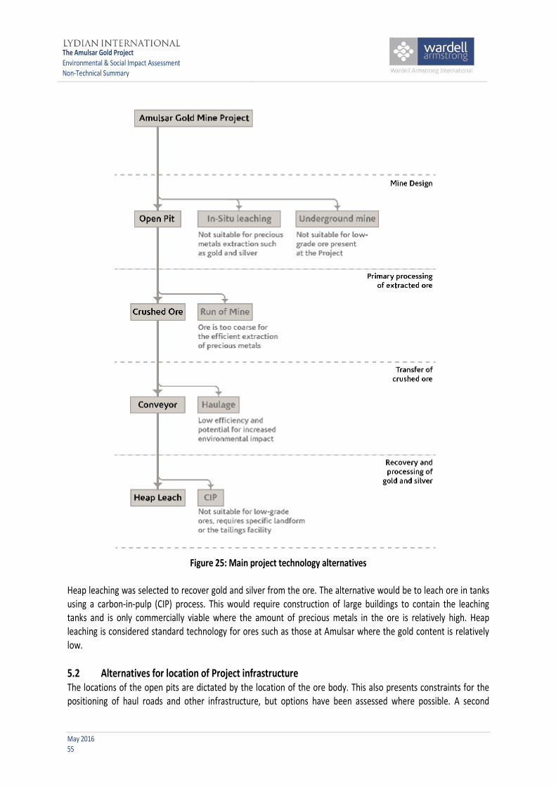
The Amulsar Gold Project Environmental & Social Impact Assessment Non-Technical Summary
May 2016 55
Figure 25: Main project technology alternatives
Heap leaching was selected to recover gold and silver from the ore. The alternative would be to leach ore in tanks using a carbon-in-pulp (CIP) process. This would require construction of large buildings to contain the leaching tanks and is only commercially viable where the amount of precious metals in the ore is relatively high. Heap leaching is considered standard technology for ores such as those at Amulsar where the gold content is relatively low. 5.2 Alternatives for location of Project infrastructure The locations of the open pits are dictated by the location of the ore body. This also presents constraints for the positioning of haul roads and other infrastructure, but options have been assessed where possible. A second
The Amulsar Gold Project Environmental & Social Impact Assessment Non-Technical Summary
May 2016 56
significant constraint is the presence of an extension of the Lake Sevan Immediate Impact Zone traversing the Project area, and within which the ore processing facilities were not allowed to be sited (see Chapter 2.5). This significantly restricted the options for the location of the HLF. Nevertheless, a comprehensive site alternatives assessment process was undertaken for both the HLF and BRSF, accounting for such considerations as ore / barren rock haulage distances; presence of communities; and presence of sensitive hydrological or biodiversity receptors. The sites that best balanced the different considerations were chosen as the preferred locations, as indicated in Figure 2. 6 ENVIRONMENTAL AND SOCIAL MANAGEMENT PLAN The Project is implementing an Environmental and Social Management Plan (ESMP) covering all design requirements, mitigation and management measures, and monitoring activities defined in the ESIA. The ESMP comprises a set of detailed discipline-specific management plans The ESMP is implemented via Lydian's Environmental and Social Management System (ESMS), which specifies the management organisation, resources and procedures necessary to ensure effective implementation The ESIA mitigation measures are also summarised in a Commitments Register that will be used to track compliance as the Project moves forward through the construction, operational and closure phases. Although the Project will be implemented by specialist contractors, Lydian has overall responsibility for the ESMP for all project phases, which commenced during Project design and will continue through the construction, operation, and closure of the mine. An overall schedule for work, the Project Execution Plan (PEP), which is consistent with the ESMP, will be developed to inform the contractor selection process. In the bidding process, prospective contractors will need to demonstrate explicitly how they would meet the needs of the Project in terms of managing environmental and social issues. All contractors will be monitored by Lydian’s environmental and social specialists to ensure that compliance with the ESMP is maintained at all times. For the duration of the Project, Lydian will publish an annual monitoring report that will assess the effectiveness of the management plans and their implementation and, where necessary, advise on changes to the ESMP. These annual reports will be made available to affected communities (through the Community Liaison Committees), other relevant authorities, and the financial lenders, with a summary report released for public disclosure. The ESMP requires Lydian to continuously develop the mine closure plan and progressively restore areas of the mine that are no longer in use. During the operational phase, further research, including the revegetation programme, will inform closure and rehabilitation planning, so that the detailed plan will be agreed and published at least two years before mine closure. 7 STAKEHOLDER ENGAGEMENT Differentiation from other mining operations and from poor legacies is core to Lydian’s narrative. Amulsar is about a new generation of mining, involving the introduction of heap leaching technology, which is conducted in accordance with Armenian laws and key international best practice standards (such as those of IFC, EBRD and the International Cyanide Management Code). To deliver on this, Lydian will work with the local community and interested stakeholders to ensure that environmental and social risks are professionally managed and that the developmental opportunities of mining are optimised. Lydian recognises that mining should be conducted transparently and accountably, to deliver the positive outcomes from mining that can be realised when government, business and civil society work together.

The Amulsar Gold Project Environmental & Social Impact Assessment Non-Technical Summary
May 2016 57
When initial exploration and prospecting for gold began in 2006, Lydian commenced informal engagement with interested stakeholders (people interested in or potentially affected by the Project). As the Project developed, Lydian formalised the approach to engagement. In 2010 Community Liaison Committees (CLCs) were created in the villages of Gndevaz, Gorayk and Saravan. In 2011 a CLC was also established in the town of Jermuk. The CLCs are structured to include representatives from different sectors of the community such as education, health and local government, and each includes both women and men and aims to ensure equal representation of interests through gender equality. The CLCs are intended to reflect the views and interests of the wider community and provide on-going communication between each community and Lydian. In 2011 a formal Stakeholder Engagement Plan (SEP) for the Project was completed. The SEP is a document that is used to guide how Lydian communicates with stakeholders during the Project’s development, operation and closure, and after the Project has ended. The SEP is designed to be a “living” document. It is updated as the Project develops and the needs of the Project managers and stakeholders evolve. The latest version of the plan was updated in May 2016. The details of stakeholder engagement during the upcoming construction phase, including anticipation of when concerns and grievances are likely to peak, are included in this latest revision. This is a publicly available document that can be downloaded from the Geoteam or Lydian websites. Each month a Community Newsletter is distributed to Gndevaz, Gorayk, Saravan and Jermuk, providing updated information on the work being carried out at the Project. A Media Newsletter is also made available regularly to a broad range of stakeholders outside the Project area. In April 2013, Lydian opened the Amulsar Information Centre in Gndevaz (see Figure 26). At the centre, people from the local communities can access information and ask questions about the Project. Information is available as videos, posters, booklets, and electronically. The centre is staffed during normal working hours by people familiar with the Project. An Amulsar Grievance Mechanism, which includes a record of questions asked by the public, is maintained, and the staff based at the information centre provide feedback to those who have asked questions, disclose further technical information and liaise with the head office in Yerevan when necessary. Free Internet access is available at the Centre for those residents who wish to learn more about the Project.

The Amulsar Gold Project Environmental & Social Impact Assessment Non-Technical Summary
May 2016 58
Figure 26: Information centre in Gndevaz during the opening ceremony
Throughout the life of the Project Lydian has held a number of formal public meetings with stakeholders. The record of engagement to the end of January 2016 is summarised in Table 4.
Table 4: Public meetings and consultations held with Amulsar Gold Project stakeholders Consultation Number Locations Comments
Official Public Hearings per the EIA Law
15 in total between November 2009 and May 2016.
Yeghegnadzor, Saravan, Gndevaz - Vayots Dzor, Gorayk – Syunik and at MNP in Yerevan
Present EIAs for various components of the mine for exploration, development and exploitation stages
Government Consultation
12 meetings on presentation, discussion and introduction to the Project, mine design and concept for operations
Yerevan Presentations on EIA progress and the ore extraction and processing methods
Community Consultation and Disclosure
Over 180 meetings since 2009 with Geoteam Community Liaison Officer (CLO) and social development team
Gndevaz, Gorayk, Ughedzor, Saravan, Jermuk
Monthly meetings with CLCs (121 to date) in four communities and regular engagement with host communities
Initial Informal Scoping
5 in total between June and July 2010
Gndevaz, Gorayk, Ughedzor, Saravan, Jermuk
FS/ESIA process and progress together with the initial findings
Formal Consultation
14 in total between May 2011 and May 2016, more to come at the time of the ESIA public disclosure later in 2016
Gorayk, Gndevaz, Saravan, Jermuk, Syunik, Vayots Dzor, Yerevan
Project and ESIA progress updates and spreading information on the Project; ESIA pre-disclosure roundtable with CSOs

The Amulsar Gold Project Environmental & Social Impact Assessment Non-Technical Summary
May 2016 59
Table 4: Public meetings and consultations held with Amulsar Gold Project stakeholders Consultation Number Locations Comments
Land acquisition meetings
At least 25 formal meetings from March 2013 to May 2016. In addition, meetings have been held with Village Mayor & land owners.
Gndevaz
Meetings were held with village Mayor, landowners to provide updates; share project maps; present compensation rates & collect feedback.
Note: “EIA” means consultations required by the Armenian legislation of the environmental impact assessment and permitting process. “ESIA” means consultations to meet the requirements of international funders.
Based on the SEP, Lydian continues to have a programme of active engagement with Civil Society Organizations (CSOs), and proactively communicates the results. Some CSOs are opposed to mining in general, but Lydian remains committed to continued engagement with all CSOs. Regular stakeholder engagement with the public in Armenia and productive cooperation with constructive CSOs is a primary objective of the SEP, with a clear commitment to transparency, accountability and open communication. Through this engagement, stakeholders have an ongoing opportunity to engage and consider the potential environmental and social impacts resulting from the Project. Lydian also accepts correspondence and feedback from stakeholders outside of the formal setting of stakeholder meetings and the grievance mechanism. 8 PUBLIC PARTICIPATION Hardcopies of the ESIA documentation are available for review for the public at the Gndevaz Amulsar Information Centre (AIC), in Yerevan and in the municipalities of the villages located around the Project. The ESIA documentation is also published online to be freely downloaded. Comments and suggestions from all interested parties will be considered during the disclosure period of the ESIA (minimum 60 days from publication as required by Equator Principles). Early in the process, Lydian will organise public consultations to provide a review of the studies that have been completed in the ESIA; these will be advertised in advance of the meetings. At these meetings members of the public and other interested stakeholders will be invited to focus group meetings to discuss concerns or suggestions with Lydian staff and their advisors, who will be available to answer specific questions relating to the Project. The recommendations in the ESIA and the approach to management of environmental, health, safety and social aspects of the Project can also be discussed. All of these activities will take place during May to July 2016.
Lydian will maintain a programme of communication with communities, the Government of Armenia, local CSOs and international NGOs and other stakeholders (including the Armenia Diaspora), guided by the SEP. Accountability and reporting on our commitment to comply with international standards throughout construction, operation and closure is a key value of Lydian. Further information on the Project can be obtained from: Lydian International Ltd: e-mail: [email protected]

The Amulsar Gold Project
Environmental & Social Impact Assessment Non-Technical Summary
February 2015
Further Information - Lydian International Ltd:
e-mail: [email protected]