information for file #200304068 - united states army · 2015-01369-tjh, 11 of 19. 180+00 185+00...
TRANSCRIPT

1
Information for File # 2015-01369-TJH
Applicant: Isanti County Highway Department
Corps Contact: Tom Hingsberger
Address: 180 E. 5th Street, Suite 700, St. Paul, Minnesota 55101-1638
E-Mail: [email protected]
Phone: (651) 290-5367
Primary County: Isanti County, MN
Sections: 2, 3, 4, 5, 9
Township: 34N
Range: 23W
Information Complete On: June 11, 2015
Posting Expires On: June 29, 2015
Authorization Type: LOP-05-MN
This application is being reviewed in accordance with the practices for documentingCorps jurisdiction under Sections 9 & 10 of the Rivers and Harbor Act of 1899 andSection 404 of the Clean Water Act identified in Regulatory Guidance Letter 07-01. Wehave made a preliminary determination that the aquatic resources that would be impactedby the proposed project are regulated by the Corps of Engineers under Section 404 of theClean Water Act. Our jurisdictional review could result in modifications to the scope ofthe project’s regulated waterbody/wetland impacts and compensatory mitigationrequirements identified above.
Project Includes: Road reconstruction to include widening, base reconstruction, culvert installations, a bridge replacement, and bituminous resurfacing.
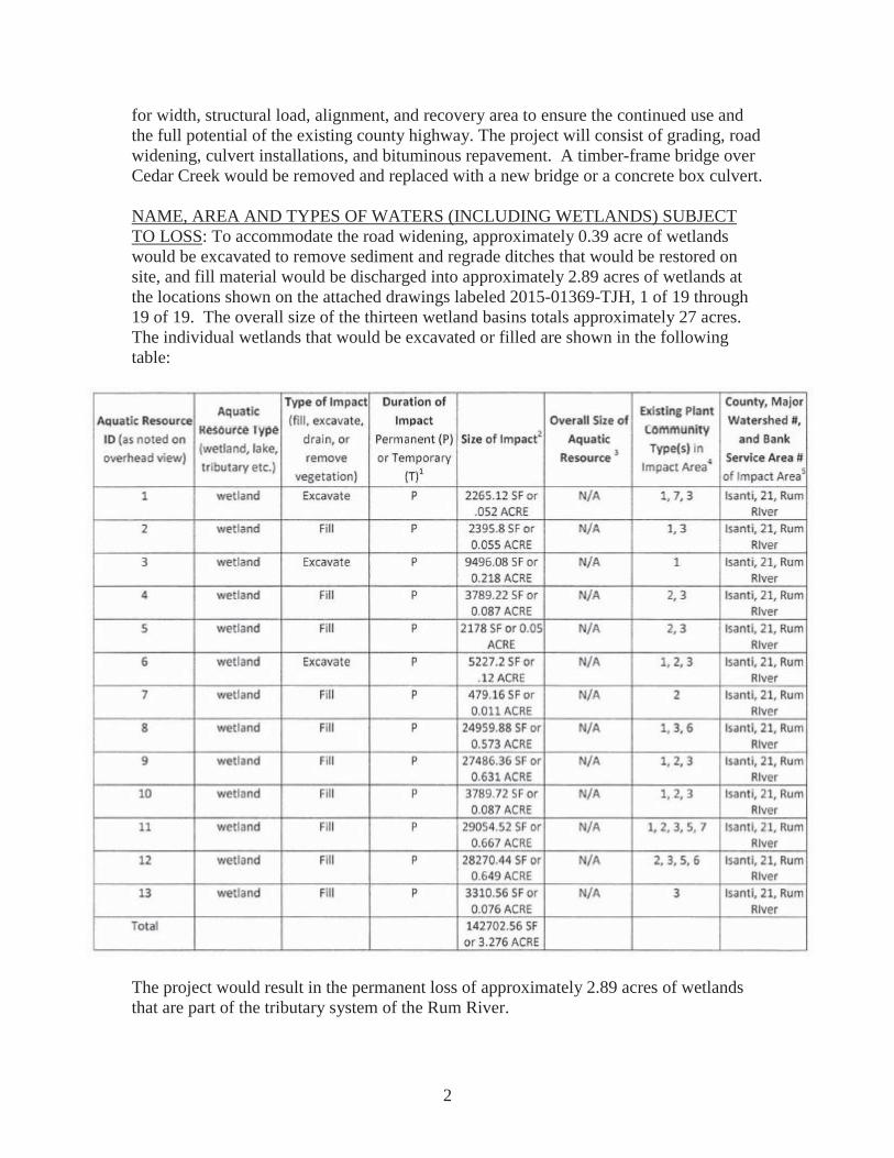
PROJECT DESCRIPTION AND PURPOSE: The applicant proposes to discharge fillmaterial into portions of thirteen wetland basins in conjunction the reconstruction of approximately 3.4 miles of C.S.A.H. 9 in Isanti County from T.H. 65 to 609' east of C.R. 45. The applicant has stated that this portion of C.S.A.H. 9 is deficient in lane width, shoulder width and structural strength, and that maintenance costs have becomeprohibitive. In 2006 access ramps were constructed on Interstate Highway 35, whichgreatly increased the average daily traffic on C.S.A.H. 9. The purpose of the project is to improve public safety by providing a highway that conforms to the minimum standards
2
for width, structural load, alignment, and recovery area to ensure the continued use and the full potential of the existing county highway. The project will consist of grading, road widening, culvert installations, and bituminous repavement. A timber-frame bridge over Cedar Creek would be removed and replaced with a new bridge or a concrete box culvert.
NAME, AREA AND TYPES OF WATERS (INCLUDING WETLANDS) SUBJECTTO LOSS: To accommodate the road widening, approximately 0.39 acre of wetlands would be excavated to remove sediment and regrade ditches that would be restored on site, and fill material would be discharged into approximately 2.89 acres of wetlands at the locations shown on the attached drawings labeled 2015-01369-TJH, 1 of 19 through 19 of 19. The overall size of the thirteen wetland basins totals approximately 27 acres. The individual wetlands that would be excavated or filled are shown in the following table:
The project would result in the permanent loss of approximately 2.89 acres of wetlands that are part of the tributary system of the Rum River.

3
ALTERNATIVES CONSIDERED: The applicant considered a no build alternative, a design alternative, and an alternate location alternative.
The no build alternative would fail to correct existing deficiencies and would cause continued road deterioration, substandard roadway geometries and increased maintenance costs. Since this alternative did not address any of the deficiencies, it was rejected.
A design alternative limited to an overlay was rejected because an overlay would not address major deficiencies that include a deteriorated subgrade, inadequate lane and shoulder width, or load capacity.
An alignment change would adversely effect existing residential access and disturb the area more than maintaining the existing alignment.
The proposed design maintains the existing horizontal alignment with slight roadway adjustments, meets or exceeds minimum safety requirements, and is minimally disruptive to the surrounding area. The existing alignment was first reconstructed in 1953. The alignment would follow the established roadway with inslopes designed at 1:4 (vertical: horizontal) or steeper with a clear zone and recovery area of 42 feet from the CSAH 9 centerline per MNDOT State Aid Highway design specifications.
COMPENSATORY MITIGATION: Compensatory mitigation for the permanent loss of approximately 2.89 acres of wetlands would be provided via a wetland credit withdrawal from the BWSR Road Replacement Program.
Drawings: See attached.
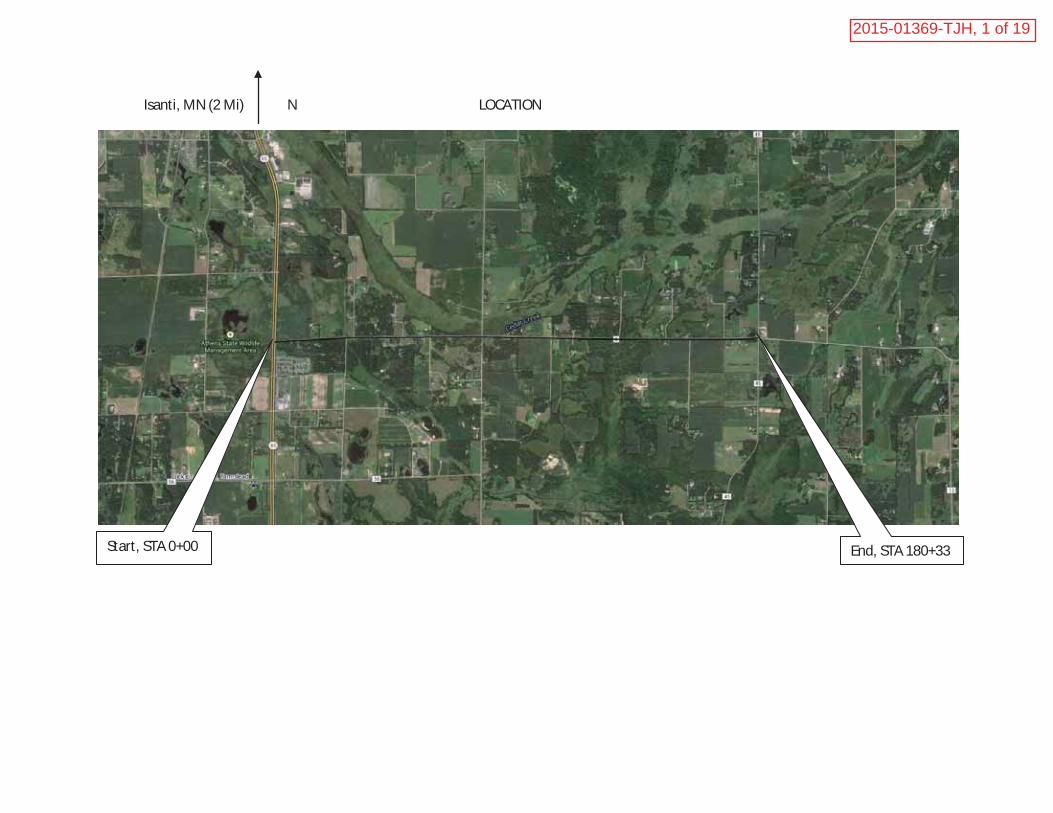
Isanti, MN (2 Mi) N LOCATION
1 Mi
Start, STA 0+00 End, STA 180+33
2015-01369-TJH, 1 of 19

PROJECT LOCATION / WETLAND IMPACT FIGURESS.P. 030-609-009 PROPOSED CENTERLINE
DELINEATION AREAS
SCALE: 1" = 200'
SHEET 1 OF 11
4-1A
2015-01369-TJH, 2 of 19

PROJECT LOCATION / WETLAND IMPACT FIGURESS.P. 030-609-009 PROPOSED CENTERLINE
DELINEATION AREAS
SCALE: 1" = 200'
SHEET 2 OF 11
3-1A
3-1B
4-1A
4-1B
2015-01369-TJH, 3 of 19

PROJECT LOCATION / WETLAND IMPACT FIGURESS.P. 030-609-009 PROPOSED CENTERLINE
DELINEATION AREAS
SCALE: 1" = 200'
SHEET 3 OF 11
5-1A
6-1A
2015-01369-TJH, 4 of 19

5-1A
6-1A
6-1B
7-1A
7-1B
PROJECT LOCATION / WETLAND IMPACT FIGURESS.P. 030-609-009 PROPOSED CENTERLINE
DELINEATION AREAS
SCALE: 1" = 200'
SHEET 4 OF 11
8-1A
9-1A
2015-01369-TJH, 5 of 19

PROJECT LOCATION / WETLAND IMPACT FIGURESS.P. 030-609-009 PROPOSED CENTERLINE
DELINEATION AREAS
SCALE: 1" = 200'
SHEET 5 OF 11
8-1A
8-1B
9-1A
9-1B
2015-01369-TJH, 6 of 19

PROJECT LOCATION / WETLAND IMPACT FIGURESS.P. 030-609-009 PROPOSED CENTERLINE
DELINEATION AREAS
SCALE: 1" = 200'
SHEET 6 OF 11
8-1B
10-1
A
10-1
B
2015-01369-TJH, 7 of 19

PROJECT LOCATION / WETLAND IMPACT FIGURESS.P. 030-609-009 PROPOSED CENTERLINE
DELINEATION AREAS
SCALE: 1" = 200'
SHEET 7 OF 11
11-1
A
2015-01369-TJH, 8 of 19

PROJECT LOCATION / WETLAND IMPACT FIGURESS.P. 030-609-009 PROPOSED CENTERLINE
DELINEATION AREAS
SCALE: 1" = 200'
SHEET 8 OF 11
2015-01369-TJH, 9 of 19

PROJECT LOCATION / WETLAND IMPACT FIGURESS.P. 030-609-009 PROPOSED CENTERLINE
DELINEATION AREAS
SCALE: 1" = 200'
SHEET 9 OF 11
2015-01369-TJH, 10 of 19

PROJECT LOCATION / WETLAND IMPACT FIGURESS.P. 030-609-009 PROPOSED CENTERLINE
DELINEATION AREAS
SCALE: 1" = 200'
SHEET 10 OF 11
2015-01369-TJH, 11 of 19

185+00180+00
PROJECT LOCATION / WETLAND IMPACT FIGURESS.P. 030-609-009 PROPOSED CENTERLINE
DELINEATION AREAS
SCALE: 1" = 200'
SHEET 11 OF 11
2015-01369-TJH, 12 of 19

2015-01369-TJH, 13 of 19

2015-01369-TJH, 14 of 19

2015-01369-TJH, 15 of 19

2015-01369-TJH, 16 of 19

2015-01369-TJH, 17 of 19

2015-01369-TJH, 18 of 19

2015-01369-TJH, 19 of 19