inca trail - andyroscoe.comandyroscoe.com/peru/guides/incatrail-print.pdf · r aobamba and on to...
TRANSCRIPT
Get off the train at Km104, stay on the south side and follow the river to the ruins at Km107.6 From here you can see MP, Wiñay Wayna, Inty Pata, and Phuyu Pata Marka. It is behind a modern settlement, across the river from railroad.5
2 ornamental facades, 6 house groups, 6 baths, fountain, road, 5 staircases, several terraces, lookout platform. Houses and buildings are on granite outcrop at top of site. Quebrada separates the site in half.5
18. INTIPUNKU. “Sun Gate.” This was seen from our campsite near Wiñay Wayna. From Machu Picchu roundtrip: 1.5hrs.6
19. MACHU PICCHU. See Guide for more details. Winter resort of Pachacuti.20. MANDORPAMPA. Location unsure. I’ve seen no photos of this place and very little description. It is just above the railroad and near Auqas Calientes. It has a 10 ft high wall that runs for 1+ km up the mountain toward Yanantin. It helped with local terrace erosion. This is very large area with quarries, circular buildings, mortars, and an observation platform. 2 camped here and met Melchor Arteaga, who told him of MP ruins.2
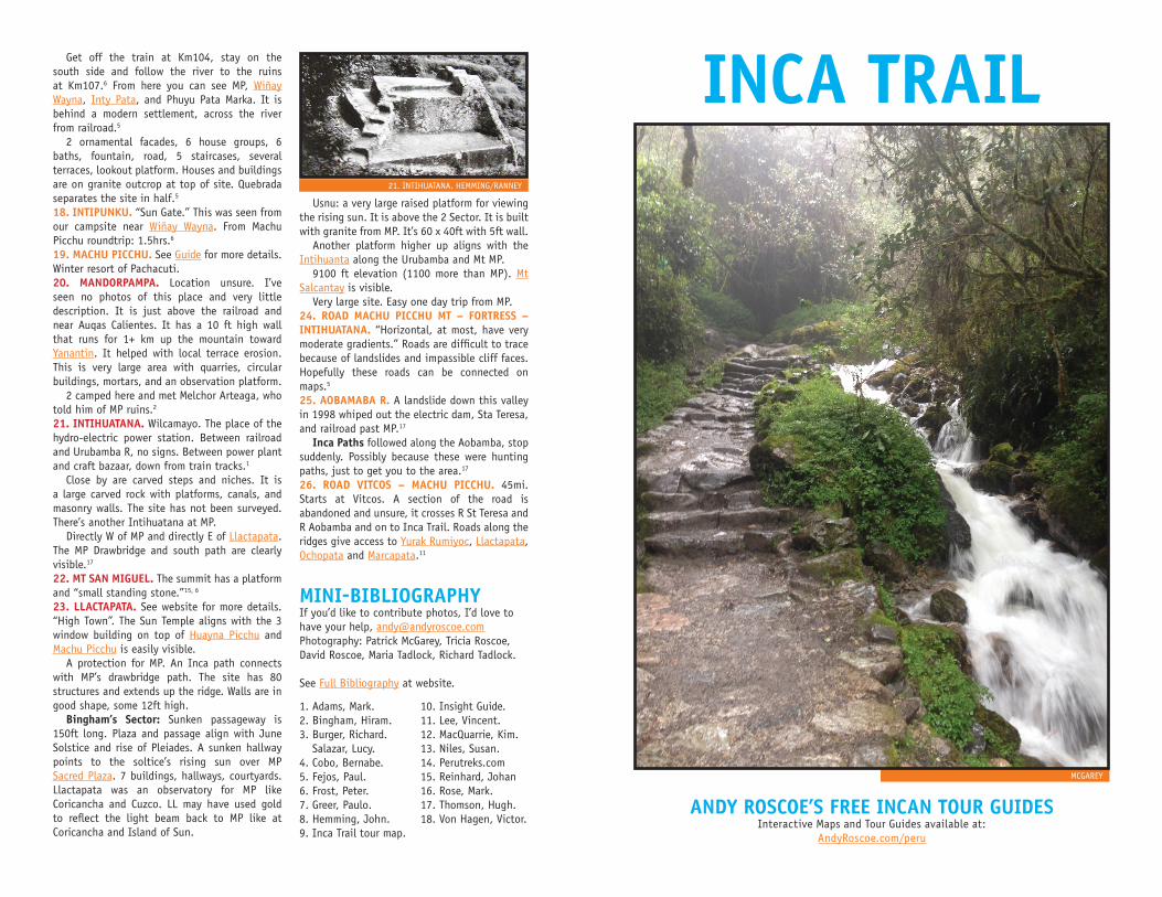
21. INTIHUATANA. Wilcamayo. The place of the hydro-electric power station. Between railroad and Urubamba R, no signs. Between power plant and craft bazaar, down from train tracks.1
Close by are carved steps and niches. It is a large carved rock with platforms, canals, and masonry walls. The site has not been surveyed. There’s another Intihuatana at MP. Directly W of MP and directly E of Llactapata. The MP Drawbridge and south path are clearly visible.17
22. MT SAN MIGUEL. The summit has a platform and “small standing stone.”15, 6
23. LLACTAPATA. See website for more details. “High Town”. The Sun Temple aligns with the 3 window building on top of Huayna Picchu and Machu Picchu is easily visible. A protection for MP. An Inca path connects with MP’s drawbridge path. The site has 80 structures and extends up the ridge. Walls are in good shape, some 12ft high. Bingham’s Sector: Sunken passageway is 150ft long. Plaza and passage align with June Solstice and rise of Pleiades. A sunken hallway points to the soltice’s rising sun over MP Sacred Plaza. 7 buildings, hallways, courtyards. Llactapata was an observatory for MP like Coricancha and Cuzco. LL may have used gold to reflect the light beam back to MP like at Coricancha and Island of Sun.
Usnu: a very large raised platform for viewing the rising sun. It is above the 2 Sector. It is built with granite from MP. It’s 60 x 40ft with 5ft wall. Another platform higher up aligns with the Intihuanta along the Urubamba and Mt MP. 9100 ft elevation (1100 more than MP). Mt Salcantay is visible. Very large site. Easy one day trip from MP.24. ROAD MACHU PICCHU MT – FORTRESS – INTIHUATANA. “Horizontal, at most, have very moderate gradients.” Roads are difficult to trace because of landslides and impassible cliff faces. Hopefully these roads can be connected on maps.5
25. AOBAMABA R. A landslide down this valley in 1998 whiped out the electric dam, Sta Teresa, and railroad past MP.17
Inca Paths followed along the Aobamba, stop suddenly. Possibly because these were hunting paths, just to get you to the area.17
26. ROAD VITCOS – MACHU PICCHU. 45mi. Starts at Vitcos. A section of the road is abandoned and unsure, it crosses R St Teresa and R Aobamba and on to Inca Trail. Roads along the ridges give access to Yurak Rumiyoc, Llactapata, Ochopata and Marcapata.11
MINI-BIBLIOGRAPHYIf you’d like to contribute photos, I’d love to have your help, [email protected]: Patrick McGarey, Tricia Roscoe, David Roscoe, Maria Tadlock, Richard Tadlock.
See Full Bibliography at website.
1. Adams, Mark.2. Bingham, Hiram.3. Burger, Richard.
Salazar, Lucy.4. Cobo, Bernabe.5. Fejos, Paul.6. Frost, Peter.7. Greer, Paulo.8. Hemming, John.9. Inca Trail tour map.
10. Insight Guide.11. Lee, Vincent.12. MacQuarrie, Kim.13. Niles, Susan.14. Perutreks.com15. Reinhard, Johan16. Rose, Mark.17. Thomson, Hugh.18. Von Hagen, Victor.
21. INTIHUATANA. HEMMING/RANNEY
INCA TRAIL
ANDY ROSCOE’S FREE INCAN TOUR GUIDESInteractive Maps and Tour Guides available at:
AndyRoscoe.com/peru
MCGAREY
2 DESCRIPTION OF LOCATIONS FROM THE RIGHT SIDE OF THE MAP.
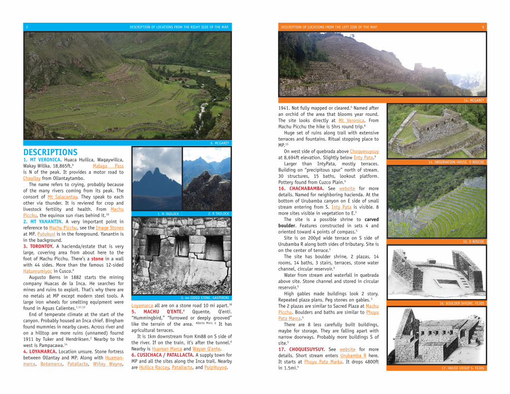
DESCRIPTIONS1. MT VERONICA. Huaca Huillca, Waqaywillca, Wakay Willka. 18,865ft.6 Malaga Pass is N of the peak. It provides a motor road to Chaullay from Ollantaytambo. The name refers to crying, probably because of the many rivers coming from its peak. The consort of Mt Salacantay. They speak to each other via thunder. It is reviered for crop and livestock fertility and health. From Machu Picchu, the equinox sun rises behind it.16
2. MT YANANTIN. A very important point in reference to Machu Picchu, see the Image Stones at MP. Putukusi is in the foreground. Yanantin is in the background.3. TORONTOY. A hacienda/estate that is very large, covering area from about here to the foot of Machu Picchu. There’s a stone in a wall with 44 sides. More than the famous 12-sided Hatunrumiyoc in Cusco.6
Augusto Berns in 1882 starts the mining company Huacas de la Inca. He searches for mines and ruins to exploit. That’s why there are no metals at MP except modern steel tools. A large iron wheels for smelting equipment were found in Aguas Calientes.7,17,12
End of temperate climate at the start of the canyon. Probably housed an Inca chief. Bingham found mummies in nearby caves. Across river and on a hilltop are more ruins (unnamed) fournd 1911 by Tuker and Hendriksen.2 Nearby to the west is Pampacawa.14
4. LOYAMARCA. Location unsure. Stone fortress between Ollantay and MP. Along with Huaman-marca, Botamarca, Patallacta, Wiñay Wayna,
Loyamarca all are on a stone road 10 mi apart.18
5. MACHU Q’ENTE.9 Qquente, Q’enti. “Hummingbird,” “furrowed or deeply grooved” like the terrain of the area. Alberto Miori, 6 It has agricultural terraces. It is 1km downstream from Km88 on S side of the river. If on the train, it’s after the tunnel.6 Nearby is Huaman Marca and Wayan Q’ante.6. CUSICHACA / PATALLACTA. A supply town for MP and all the sites along the Inca trail. Nearby are Huillca Raccay, Patallacta, and Pulpituyoq.
6. MCGAREY
3. 44-SIDED STONE. GASPIRINI
1. M TADLOCK 2. R TADLOCK
DESCRIPTION OF LOCATIONS FROM THE LEFT SIDE OF THE MAP. 9
1941. Not fully mapped or cleared.5 Named after an orchid of the area that blooms year round. The site looks directly at Mt Veronica. From Machu Picchu the hike is 5hrs round trip.6
Huge set of ruins along trail with extensive terraces and fountains. Ritual stopping place to MP.15
On west side of quebrada above Choquesuysuy at 8,694ft elevation. Slightly below Inty Pata.5
Larger than IntyPata, mostly terraces. Building on “precipitous spur” north of stream. 30 structures, 15 baths, lookout platform.
Pottery found from Cuzco Plain.5
16. CHACHABAMBA. See website for more details. Named for neighboring hacienda. At the bottom of Urubamba canyon on E side of small stream entering from S. Inty Pata is visible. 8 more sites visible in vegetation to E.5
The site is a possible shrine to carved boulder. Features constructed in sets 4 and oriented toward 4 points of compass.5
Site is on 200yd wide terrace on S side of Urubamba R along both sides of tributary. Site is on the center of terrace.5
The site has boulder shrine, 2 plazas, 14 rooms, 14 baths, 3 stairs, terraces, stone water channel, circular reservoir.5
Water from stream and waterfall in quebrada above site. Stone channel and stored in circular reservoir.5
High gables made buildings look 2 story. Repeated plaza plans. Peg stones on gables. 5
The 2 plazas are similar to Sacred Plaza at Machu Picchu. Boulders and baths are similar to Phuyu Pata Marca.5
There are 8 less carefully built buildings, maybe for storage. They are falling apart with narrow doorways. Probably more buildings S of site.5
17. CHOQUESUYSUY. See website for more details. Short stream enters Urubamba R here. It starts at Phuyu Pata Marka. It drops 4800ft in 1.5mi.5
15. D ROSCOE
16. BOULDER SHRINE. FEJOS
17. HOUSE GROUP 5. FEJOS
14. OBSERVATION HOUSE. D ROSCOE
14. MCGAREY
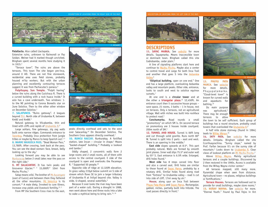
Patallacta. Also called Llactapata. Extensive ruins, unknown to Raimondi or Paz Soldan. Weiner had it marked though unvisited. Bingham spent several months here studying it in 1915.2
“Terrace town”. The ruins are above the terraces. This town The site began pre-inca, around 0 AD. There are not fine stonework, residential area uses field stones, probably housed m’ita workers. But with the urban planning and excellently contouring terraces suggest it was from Pachacutec’s panaca.6 Pulpituyoq. Sun Temple. “Pulpit having” below the ruins along the Cusichaca R. There is a curved building with a rock huaca inside.6 It aslo has a cave underneath. Two windows: 1- to the NE pointing to Corona Borealis star on June Solstice. Then to the other other window on December Solstice.1
7. SALAPUNCO. “Ruins gateway”. 2 leagues beyond Piri. North side of Urubamba R, between Km82 and Km88.6
Natural gateway to Vilcabamba, thin and lined with cliffs and rapids of Urubamba R.2 Large ashlars, fine gateways, zig zag walls built onto narrow ridges. Commands entrance to Torontoy. Probably Inca protection from jungle tribes or maybe by Manco to keep Spanish out.2, 3
8. WARMI WANUSCA PASS. “Dead Woman Pass,” 13,780ft. After crossing, look back at the pass. You can see the dead woman: face, breast, belly looking up to the sky.1
Looking forward you may be able to see Runkuracay below 2 small lakes near the pass on the right side.6
9. MT SALACANTAY. It has twin peaks and Grosvenor Glacier.17, 2 15,000ft17 10mi from Machu Picchu.5
Salqa means wild. The brother of Mt Ausangate (east of Cuzco) and between them they fathered all the other mountains. Mt Veronica is its consort.16 A male diety. Invoked to cure illness, increase crop yields and livestock fertility.15, 3
From MP the Southern Cross rises to the east,
peaks directly overhead and sets to the west over Salacantay.16 On December Solstice, The Southern Cross appears directly overhead.1
10. RUNCU RACCAY. Runkurakay. A fortified station, late Incan – circular in shape.2 Means “basket-shaped” building.16 Probably a lookout and tambo.6
Oddly shaped, 2 concentric walls form 2 large rooms and 2 small rooms, all of them with access to the central courtyard. E side of the courtyard is open and overlooks the Pacamayo R. 6 Supported 50 people.18
Opposite side of ridge at 12,320ft elevation. In grass valley 219yd below summit on S side of stream which flows SE to join a larger tributary of Urubamba R at 545yd beyond site. Valley is wide, U-shaped, several waterfalls.5
Because it over looks the river may have been part of a water cult. During a drought in 1988, men went above here and threw rocks into a lake to wake a mythical being to bring rain.15, 16
DESCRIPTIONS11. SAYAC MARKA. See website for more details. Sayaqmarka. Means inaccessible town or dominant town. Bingham called this site Cedrobamba, cedar plain.5 A line of signaling platforms start here and continue to Machu Picchu. Maybe also a center to control travel and cargo for both Inca Trail and another that goes S into the Aobamba Valley.6
“Elliptical building, open on one end.” One end has a large platform, overlooking Aobamba valley and mountain peaks. Other side, entrance, looks to south and west to solstice equinox sunsets.1
At one end is a circular tower and at the other a triangular plaza.16 12,450ft. An entrance court then 5 successive house groups – save space, 21 rooms, 3 baths – 1 in house, rest on terraces. Only 4 terraces, not an agricultural village. Wall with niches was built into rockface to protect road.5
Conchamarka. Road rounds a small “promontory” on which SM is. On second terrace on promontory are 3 houses inside courtyard. 200m north of SM.5
12. TUNNEL AND HOUSE. Tunnel is 66ft long and cut through solid granite. Runs north 80º W. Tunnel is split into 2 parts – east and west. There is an opening in the middle.5
East side slopes upwards at 8.5º. This part probably natural. Walls are formed by smooth joint planes. Inner wall dips 75.5º and outer wall by 55º S. East entrance is 6.5ft wide. Enlarged, drill holes found.5
West side has 8 steps carved into floor and also a carved seat. Drill holes are similar to those found at Sayac Marca, probably by a rotatary drill. Similar holes found along road from “fortress” to Urubamba valley – road is cut into side of cliff, 17mi away by air.5
House, along spur on Inca Trail between Phuyu Pata Marca and Sayac Marca. Rectangular, gabled, niches, partially built into hillside. The road passes directly in front.5
13. PHUYU PATA MARCA. See website for more details. P h u y u p a t a ma r k a . “Cloud-level town” is known for curved walls and aqueducts for bathing.10
Its main purpose was agricultural.5 There may be enough terraces to allow the town to be self sufficient. Each group of buildings has a round structure, probably small towers that overlooked the Urubamba R.6
A half mile stone stairway (found in 1984) leads to Wiñay Wanya.10
14. INTY PATA. See website for more details. Intipata. Bingham called the site Ccorihuayrachina. “Sunny slope,” named by Prof. Farfan because it’s on the sunny side of mountain.5 Looks down to Urubamba R. Clear views of lookout platform on Mt Machu Picchu.5
Above Wiñay Wayna. Mainly agricultural terraces and a couple buildings. Discovered by 2 then restored in the 1990s. Access is available from the Wiñay Wayna visitor center.6
48 terraces mapped, still many more. Pyramidal shape when seen from distance. Agricultural town – no plazas, religious buildings or fortifications.5
Terrace Houses. Terraces are hollowed out to provide for small buildings, maybe store rooms.5
15. WIÑAY WAYNA. See website for more. “Eternal Youth.” Found by Paul Fejos in Oct
11. D ROSCOE
12. D ROSCOE
13. MCGAREY
11. CONCHAMARKA. D ROSCOE
3 DESCRIPTION OF LOCATIONS FROM THE RIGHT SIDE OF THE MAP. DESCRIPTION OF LOCATIONS FROM THE LEFT SIDE OF THE MAP. 8
7. MCGAREY
8. D ROSCOE
10. D ROSCOE

DESCRIPTION OF LOCATIONS ON THE RIGHT SIDE OF THE MAP ARE FOUND ON PAGE 2.DESCRIPTION OF LOCATIONS ON THE LEFT SIDE OF THE MAP ARE FOUND ON PAGE 6.
1. MT VERONICA2. MT YANANTIN3. TORONTOY4. LOYAMARKA5. MACHU Q’ENTE6. CUSICHACA / PATALLACTA7. SALAPUNCO8. WARMI WANUSCA PASS9. MT SALCANTAY10. RUNCU RACCAY
11. SAYAC MARKA12. TUNNEL & HOUSE13. PHUYU PATA MARKA14. INTI PATA15. WIÑAY WAYNA16. CHACHABAMBA17. CHOQUESUYSUY18. INTI PUNKU / SUN GATE19. MACHU PICCHU20. MANDOR PAMPA
21. INTIHUATANA22. MT SAN MIGUEL23. LLACTAPATA24. RD MACHU PICCHU MT – FORTRESS –
INTIHUATANA25. RD AOBAMBA R26. RD ROSAPATA – MACHU PICCHU
7
6
5
LEGENDLocation without photo.
Location with photo.
Google Maps
Location with needed photo.
1
76
4
2
1514
18
19
20
21
22
3
5
8
1011
12
13
1617
25
24
26
9
23