impact of combining gps-glonass data on base line solution
TRANSCRIPT

1
Impact of combining GPS-GLONASS data on base
line solution
Mervat M. Refaat
Lecturer
Department of Surveying Engineering
Faculty of Engineering Shoubra - Benha University
ملخص البحث. تى تطىيش او يذي انىثىق به اودلته هاتىافش خلال يٍ (GNSSانعانًيت انًلاحيت ) الالًاس َظى اداء لياس يًكٍ
( RTK(. يهعب َظاو)GPSانعانًي) انًىالع تحذيذ َظاو لبم انًساحت و انًلاحت عهً يذي انعمذيٍ الاخشيٍ يٍ
فأٌ انحصىل رنك ويع. ت بذلتانُسبي انًىالع نتحذيذ أساسيت أداة دوس يهى فً تحسيٍ انًساحت و انًلاحت وأصبح
. انًىالع نتحذيذ انصُاعيت الألًاس يٍ كبيش عذد عهً انًلاحظت عهً تعتًذ وانصحيحت انًىثىلت انغًىض عهً
انتكايم نزنك. يحذودة انًشئيت الالًاس عذد فيها يكىٌ انتي انًُاطك عهً طبكت أٌ انصعب يٍ انتمُيت هزِ
تىفيشو يعًم عهً ( بىاسطت انشوس GLONSSَشش). أكثشويىثىليت دلت (يحذثGLONSS(و)GPSبيٍ)
انعانًيت َظى الالًاس جًيع يٍ انكايم انتعاوٌ. نهًستخذييٍ حانيا انًتىفشة انًلاحيت الالًاس عذد يضاعفت
انتكايم. و يٍ تىلع يًكٍ الالًاس, ونزنك تىافش يٍ نًستىياث عانيت يعت انتىصم ( سىف يتىGNSSانًلاحيت)
انتطىساث. هزة سدسجتانًهى استثًا
Abstract
The execution of Global Navigation Satellite System (GNSS) can be measured by
availability, accuracy and reliability. Surveying and navigation industries have been
developed over the past two decades by the Global Positioning System (GPS). Real
time kinematic GPS precise positioning has been playing an important role in both
surveying and navigation, and has become an essential tool to precise relative
positioning. However, reliable and correct ambiguity resolution depend on
observation upon large number of GPS satellites. This technique is difficult to be
applied on areas where the number of visible satellites are limited. With integration
between GPS and GLONASS more and more accuracy and reliability happens. The
deployment of GLONASS by Russian will provide double the number of navigation
satellites currently available to users. With the complete co-operation of all of these
Global Navigation Satellite Systems (GNSS) greater levels of availability will be
reached. Therefore integrity can be expected. It is important to investigate the degree
of these improvements.
Introduction
The Global Navigation Satellite Systems (GNSS) are expecting more satellite
constellations to be developed, such as the Chinese Compass, European Galileo and
Japanese QZSS, etc. Currently, however, only GPS and GLONASS have been widely
used around the world, and the integration of these two satellite systems have greatly

2
improved the number of available satellites, thus allowing more accurate and reliable
positioning results. The demand of this integration is still high, and when the
completed GLONASS satellite system is available, the expected number of satellites
for the integration of GPS and GLONASS can reach 48, which makes fast static and
kinematic positioning much more feasible than by either system alone. At present, the
number of operating GLONASS satellites is 23.
This paper investigates the effect of combining GPS and GLONASS dual-frequency
measurements on relative solution on different baselines with different processing
strategies. Many data sets from IGS tracking stations(Drag) and (Nico) to improve the
accuracy of the control points using the Trimple business Center (TBC) software
package. It is shown that the addition of GLONASS constellation improves the
number of visible satellites and geometry (PDOP).Statistical analysis of relative
results shows that the performance of the combined GPS/GLONASS solution is
superior to that of GPS-only solution. However, there are improvement in the
accuracy of the baselines.
Data
The data was collected in different regions, in the form of geodetic networks. The first
network area was in Giza (Grand Egyptian Museum). The study area was far away
from Midan El Rmaia almost 1 km. . The baselines in this network were only 1 km .
The second network was in Qenna (Isna Qenna). The third network was in 6th
of
October. The length of base lines starts from tens of meters till hundreds of kilo
meters. At Giza, , which were monitored for a period of time starting from 30 minutes
to 60 minutes, depending on the length of the base line. At Qenna (Isna Qenna), the
base lines join between control points of the network with length ranged from 5 Km
till more than 100 Km. They were observed in suitable conditions. As the length of
the base line increases the period of observation increases. At 6th
of October, the base
lines exceed 6000 Km due to connecting the control points of this network with IGS
station(DRAG) and (NICO) to solve the network. In this research, we used Trimble
R8 GNSS which, delivers the latest advancements in R-Track™ technology, designed
to deliver reliable, precise positioning performance In challenging areas for GNSS
surveying, such as tree or limited sky view, Trimble R-Track provides unmatched
tracking performance of GNSS satellite signals. The Trimble R8 GNSS supports a

3
wide range of satellite signals, including GPS L2C and L5 and GLONASS L1/L2
signals.
Figure (1) represents "6 October" Network Figure (2) represents "Giza Network"
Figure (3) represents "Isna-Qena Network"

4
Brief overview of GPS and GLONASS
Today GPS and GLONASS are the main GNSS systems. They are similar in many
respects, both systems are able to provide with the three-dimensional positioning,
velocity and timing anywhere in the world or near-Earth space. Both navigation
systems are based on determining the unknown user position by measuring the time of
flight of signals broadcasted by satellites at known positions and epochs.
GPS: Consists of 28 satellites inclined at 55° to the equator, orbit the Earth every 11
hours and 58 minutes at a height of 20,180 km on 6 different orbital planes. Each one
of these satellites has up to four atomic clocks on board. Atomic clocks are currently
the most precise instruments known. In order to make them even more accurate, they
are regularly adjusted or synchronised from various control points on earth. Each
satellite transmits its exact position and its precise on board clock time to earth at
frequency of 1575.42 MHz. These signals are transmitted at the speed of light
(300,000 km/s) . Therefore, If you wish to establish your position on land(or at sea or
in the air ), all you require is an accurate clock. By comparing the arrival time of the
satellite signal with the onboard clock time (the moment the signal was emitted). So it
is possible to determine the transit time of that signal.��
GLONAS, The International GLONASS Experiment (IGEX-98) is the first global
GLONASS observation and analysis campaign for geodetic and geodynamics
applications, conducted from October 19, 1998 to April 19, 1999 and organized
jointly by the International GNSS Service (IGS), the International Association of
Geodesy (IAG) and the International Earth Rotation Service (IERS). The main
objectives of the experiment were to collect a globally-distributed GLONASS dataset
by using dual frequency GLONASS receivers and determine the precise GLONASS
satellite orbit. IGEX-98 has a global network consisting of 52 stations with 19 dual-
frequency and 13 single-frequency receivers. GLONASS has been on the way to its
modernization. In 2003, the first GLONASS-M satellite was launched, where “M”
stands for Modified. On December 25, 2006, three GLONASS-M satellites
(GLONASS 715, GLONASS 716 and GLONASS 717) were launched. The
GLONASS-M is a modernized version of the GLONASS spacecraft which supports a
number of new features, such as the satellite design-lifetime increased to 7 years, a
second civil modulation on L2 signal, and improved clock stability. The third
generation GLONASS satellite, GLONASS-K, was launched on 26 February 2011.

5
The new satellite has an operational lifetime of 10 years, three years longer than that
of GLONASS-M and seven years longer than the lifetime of the original GLONASS
satellite. GLONASS-K will transmit additional navigation signals to improve the
system's accuracy.
Numerical Results and Analysis
The observations from the four mentioned networks have been processed using the
Trimple Business Center (TBC) software package. GPS-only and GPS/GLONASS
observations are processed respectively using the same processing strategy. The
results of the GPS-only baselines and GPS/GLONASS baselines have been compared.
The research studies the effect of the integration between GPS and GLONASS on the
accuracy of baseline on the four networks through the following different solutions:
solving by GPS/GLONASS with broadcast ephemeris, precise ephemeris of
GPS/GLONASS, precise ephemeris of GPS satellite, precise ephemeris of
GLONASS, and solving by GPS only with broadcast ephemeris and precise
ephemeris. The study results are shown in the following tables and figures:

6
Table (1):Giza, this study was characterized by baseline with length less than1
Km.
Observation H.Prec.
V.
Prec. Geodetic
Az.
Ellipsoid
Dist. ΔHeight
RMS RMS**6
(Meter) (Meter) (Meter) (Meter)
B05 --M18(B22) 0.001 0.002 213°35'33" 83.033 2.486 0 0
B05 --- P06
(B10) 0.001 0.003 119°35'36" 148.192 -5.674 0 0
B05 --- P06 (B8) 0.057 0.032 119°38'29" 148.342 -5.718 0 0
B05 --- m02(B12)
0.001 0.003 120°24'34" 153.018 -6.853 0 0
M18 ---
P06(B20) 0.001 0.003 91°18'59" 174.847 -8.159 0 0
M18 ---
P06(B21) 0.034 0.022 91°22'42" 174.922 -8.202 0 0
M18-- m02
(B19) 0.001 0.003 92°40'02" 178.101 -9.337 0 0
P03 --- P11 (B16)
0.003 0.005 122°42'04" 251.038 -8.868 0 0
P11 --- p02 (B18) 0.001 0.002 273°23'39" 254.473 7.138 0 0
P11 --- P04 (B17)
0.002 0.003 320°05'52" 287.45 7.124 0 0
B05 --- P04 (B2) 0.002 0.003 208°57'46" 310.152 32.491 0 0
P03 ---
M18(B23) 0.001 0.002 24°32'35" 315.605 -31.755 0 0
P11 --- P10
(B14) 0.001 0.002 148°18'13" 344.812 6.862 0 0
B05 --- P03 (B1) 0.001 0.002 206°25'30" 397.819 34.242 0 0
P03 --- m02 (B13)
0.002 0.004 47°56'28" 416.19 -41.09 0 0
P03 --- P06
(B11) 0.002 0.003 47°13'08" 416.778 -39.913 0 0
B05 --- P11 (B15)
0.001 0.002 176°01'19" 493.067 25.373 0 0
B05 --- p02 (B3) 0.001 0.002 204°45'01" 525.043 32.516 0 0
P10 --- p02 (B7) 0.002 0.003 305°19'41" 533.42 0.276 0 0
P03 --- P10 (B5) 0.003 0.004 137°32'58" 581.412 -2.009 0 0
P10 --- P04 (B6) 0.002 0.004 324°34'29" 630.655 0.261 0 0
B05 --- P10 (B4) 0.001 0.002 164°39'44" 814.26 32.234 0 0
Qenna (Qenna El Gedida), this study was characterized by presence of baselines with
lengths between 10Km till more than 30Km and the study is done according to the six
cases and the results were as follow:
7
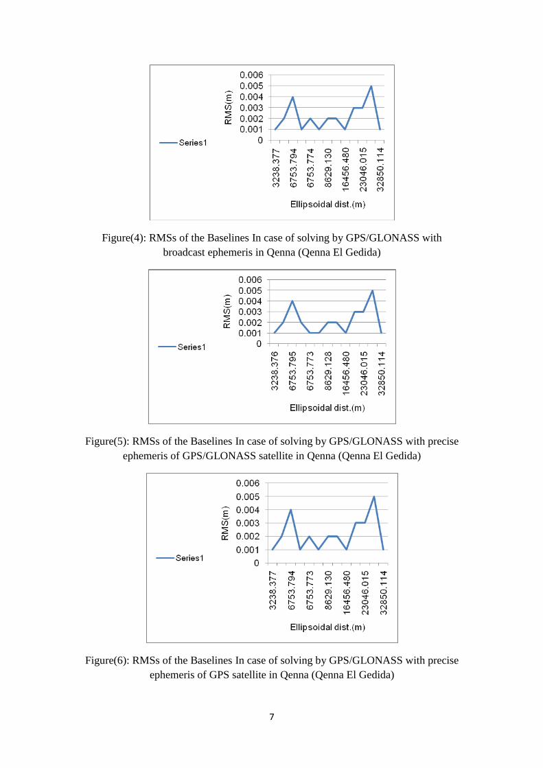
Figure(4): RMSs of the Baselines In case of solving by GPS/GLONASS with
broadcast ephemeris in Qenna (Qenna El Gedida)
Figure(5): RMSs of the Baselines In case of solving by GPS/GLONASS with precise
ephemeris of GPS/GLONASS satellite in Qenna (Qenna El Gedida)
Figure(6): RMSs of the Baselines In case of solving by GPS/GLONASS with precise
ephemeris of GPS satellite in Qenna (Qenna El Gedida)
8
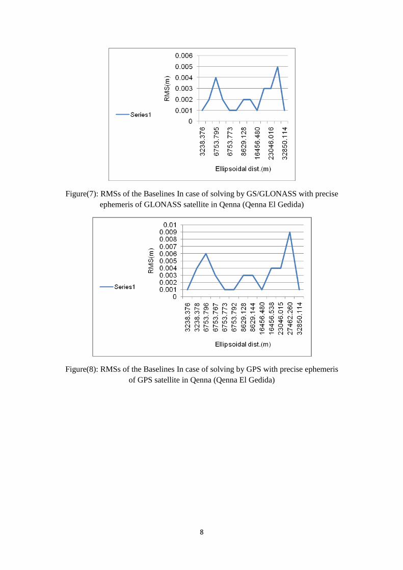
Figure(7): RMSs of the Baselines In case of solving by GS/GLONASS with precise
ephemeris of GLONASS satellite in Qenna (Qenna El Gedida)
Figure(8): RMSs of the Baselines In case of solving by GPS with precise ephemeris
of GPS satellite in Qenna (Qenna El Gedida)

9
Figure(9): RMSs of the Baselines In case of solving by GPS with broad cast
ephemeris of GPS satellite in Qenna (Qenna El Gedida)
Qenna (Isna-Qenna), this study was characterized by presence of baselines
with lengths between 5Km till more than 100Km. They were observed in
suitable conditions. the length of baseline is directly proportional to the epoch.
Table (2): In case of solving by GPS/GLONASS with broadcast ephemeris in
Qenna(Isna-Qenna)
Observation H.
Prec.
(Meter)
V.
Prec.
(Meter)
Geodetic
Az.
Ellipsoid
Dist.
(Meter)
ΔHeight
(Meter)
RMS RMS*10**6 Duration
HL-04 ---
HL-03 (B4)
0.004
0.019
313°21'52"
5633.215
-0.004
0.004
4000 03:56:35
GPS-01 --- HL-03 (B5)
0.008
0.025
185°36'54"
93379.473
-29.158
0.005
5000 04:07:25
GPS-01 ---
HL-04 (B2)
0.010
0.033
182°58'55"
96932.240
-29.125
0.008
8000 04:13:15
GPS-02 --- HL-04 (B3)
0.011
0.037
186°23'13"
103233.463
-17.652
0.013
13000 04:13:15

10
Figure(10): RMSs of the Baselines In case of solving by GPS/GLONASS with
broadcast ephemeris in Kenna(Isna-Kenna)
Table (3): In case of solving by GPS/GLONASS with precise ephemeris of
GPS/GLONASS satellite in Kenna(Isna-Kenna).
Observations H.
Prec.
(Meter)
V.
Prec.
(Meter)
Geodetic
Az.
Ellipsoid
Dist.
(Meter)
ΔHeight
(Meter)
RMS RMS*10**6 Duration
HL-04 --- HL-
03 (B4)
0.005
0.020
313°21'53"
5633.215
0.000
0.005
5000 03:56:35
GPS-01 ---
HL-03 (B5)
0.007
0.023
185°36'54"
93379.474
-29.159
0.003
3000 04:07:25
GPS-01 ---
HL-04 (B2)
0.010
0.037
182°58'55"
96932.240
-29.135
0.006
6000 04:13:15
GPS-02 ---
HL-04 (B3)
0.010
0.030
186°23'13"
103233.461
-17.642
0.007
7000 04:13:15
Figure(11): RMSs of the Baselines In case of solving by GPS/GLONASS with
precise ephemeris of GPS/GLONASS satellite in Kenna(Isna-Kenna)
11
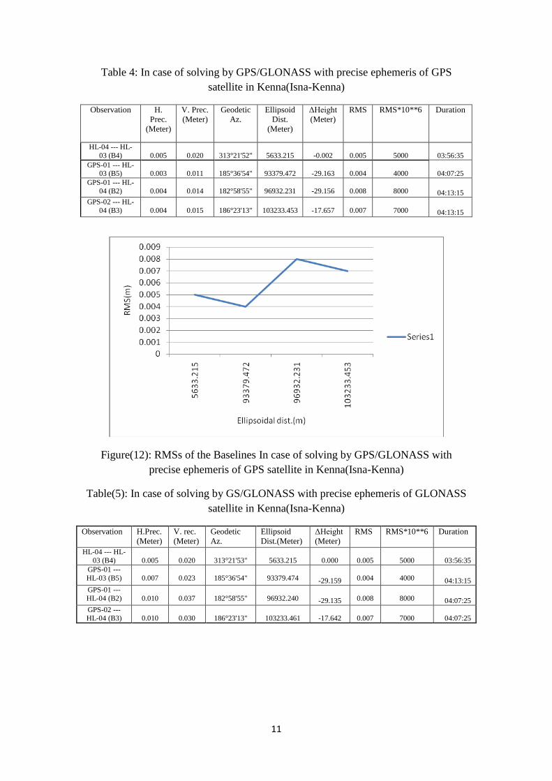
Table 4: In case of solving by GPS/GLONASS with precise ephemeris of GPS
satellite in Kenna(Isna-Kenna)
Observation H.
Prec.
(Meter)
V. Prec.
(Meter)
Geodetic
Az.
Ellipsoid
Dist.
(Meter)
ΔHeight
(Meter)
RMS RMS*10**6 Duration
HL-04 --- HL-
03 (B4)
0.005
0.020
313°21'52"
5633.215
-0.002
0.005
5000 03:56:35
GPS-01 --- HL-03 (B5)
0.003
0.011
185°36'54"
93379.472
-29.163
0.004
4000 04:07:25
GPS-01 --- HL-
04 (B2)
0.004
0.014
182°58'55"
96932.231
-29.156
0.008
8000 04:13:15
GPS-02 --- HL-
04 (B3)
0.004
0.015
186°23'13"
103233.453
-17.657
0.007
7000 04:13:15
Figure(12): RMSs of the Baselines In case of solving by GPS/GLONASS with
precise ephemeris of GPS satellite in Kenna(Isna-Kenna)
Table(5): In case of solving by GS/GLONASS with precise ephemeris of GLONASS
satellite in Kenna(Isna-Kenna)
Observation H.Prec.
(Meter)
V. rec.
(Meter)
Geodetic
Az.
Ellipsoid
Dist.(Meter)
ΔHeight
(Meter)
RMS RMS*10**6 Duration
HL-04 --- HL-
03 (B4)
0.005
0.020
313°21'53"
5633.215 0.000
0.005
5000 03:56:35
GPS-01 ---
HL-03 (B5)
0.007
0.023
185°36'54"
93379.474 -29.159
0.004
4000 04:13:15
GPS-01 ---
HL-04 (B2)
0.010
0.037
182°58'55"
96932.240 -29.135
0.008
8000 04:07:25
GPS-02 --- HL-04 (B3)
0.010
0.030
186°23'13"
103233.461 -17.642
0.007
7000 04:07:25

12
Figure(13): RMSs of the Baselines In case of solving by GS/GLONASS with precise
ephemeris of GLONASS satellite in Kenna(Isna-Kenna)
Table (6): In case of solving by GPS with precise ephemeris of GPS satellite in
Kenna(Isna-Kenna)
Observation H. Prec.
(Meter)
V. Prec.
(Meter)
Geodetic
Az.
Ellipsoid
Dist.(Meter)
ΔHeight
(Meter)
RMS RMS*10**6 Duration
HL-04 --- HL-
03 (B4)
0.006
0.029 313°21'53"
5633.216
0.019
0.01
10000 03:56:35
GPS-01 --- HL-03 (B5)
0.010
0.028 185°36'54"
93379.476
-29.163
0.012
12000 04:13:15
GPS-01 ---
HL-04 (B2)
0.014
0.046 182°58'55"
96932.239
-29.129
0.01
10000 04:07:25
GPS-02 --- HL-04 (B3)
0.012
0.044 186°23'13"
103233.458
-17.645
0.012
12000 04:07:25
Figure(14): RMSs of the Baselines In case of solving by GPS with precise ephemeris
of GPS satellite in Kenna(Isna-Kenna)

13
Table (7): In case of solving by GPS with broad cast ephemeris of GPS
satellite in Kenna(Isna-Kenna)
Observation H.
Prec.
(Meter)
V.
Prec.
(Meter)
Geodetic
Az.
Ellipsoid
Dist.
(Meter)
ΔHeight
(Meter)
RMS RMS*10**6 Duration
HL-04 --- HL-03 (B4)
0.007
0.030
313°21'53"
5633.216
0.022
0.012
12000
03:56:35
GPS-01 ---
HL-03 (B5)
0.003
0.011
185°36'54"
93379.472
-29.164
0.011
11000 04:07:25
GPS-01 --- HL-04 (B2)
0.005
0.018
182°58'55"
96932.230
-29.154
0.015
15000 08:00:40
GPS-02 ---
HL-04 (B3)
0.005
0.018
186°23'13"
103233.452
-17.654
0.013
13000 04:13:15
Figure(15): RMSs of the Baselines In case of solving by GPS with broad cast
ephemeris of GPS satellite in Kenna(Isna-Kenna)
6th
of October, this study was characterized by presence of baselines with length
exceed 6000 Km due to the usage of IGS in solving the network.
14
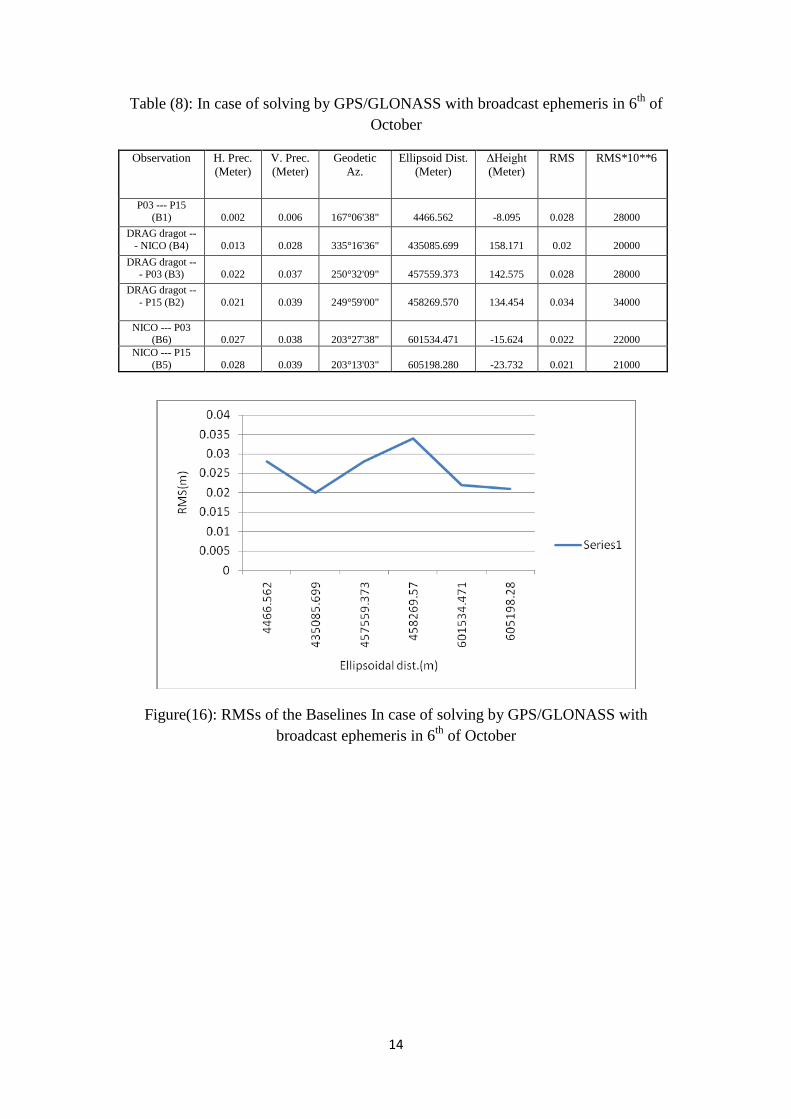
Table (8): In case of solving by GPS/GLONASS with broadcast ephemeris in 6th
of
October
Observation H. Prec.
(Meter)
V. Prec.
(Meter)
Geodetic
Az.
Ellipsoid Dist.
(Meter)
ΔHeight
(Meter)
RMS RMS*10**6
P03 --- P15
(B1)
0.002
0.006
167°06'38"
4466.562
-8.095
0.028
28000
DRAG dragot --
- NICO (B4)
0.013
0.028
335°16'36"
435085.699
158.171
0.02
20000
DRAG dragot --- P03 (B3)
0.022
0.037
250°32'09"
457559.373
142.575
0.028
28000
DRAG dragot --
- P15 (B2)
0.021
0.039
249°59'00"
458269.570
134.454
0.034
34000
NICO --- P03 (B6)
0.027
0.038
203°27'38"
601534.471
-15.624
0.022
22000
NICO --- P15
(B5)
0.028
0.039
203°13'03"
605198.280
-23.732
0.021
21000
Figure(16): RMSs of the Baselines In case of solving by GPS/GLONASS with
broadcast ephemeris in 6th
of October

15
Table( 9): In case of solving by GPS/GLONASS with precise ephemeris for
GPS/GLONASS satellites in 6th
of October.
Observation H. Prec.
(Meter)
V. Prec.
(Meter)
Geodetic
Az.
Ellipsoid Dist.
(Meter)
ΔHeight
(Meter)
RMS RMS*10**6
P03 --- P15 (B1)
0.002
0.006
167°06'38"
4466.562
-8.095
0.001
1000
DRAG dragot ---
NICO (B4)
0.002
0.005
335°16'36"
435085.712
158.174
0.014
14000
DRAG dragot ---
P03 (B3)
0.003
0.008
250°32'09"
457559.382
142.596
0.008
8000
DRAG dragot ---
P15 (B2)
0.003
0.008
249°59'00"
458269.586
134.474
0.006
6000
NICO --- P03
(B6)
0.003
0.008
203°27'38"
601534.480
-15.575
0.005
5000
NICO --- P15 (B5)
0.003
0.008
203°13'03"
605198.288
-23.691
0.003
3000
Figure(17): RMSs of the Baselines In case of solving by GPS/GLONASS with
precise ephemeris of GPS/GLONASS satellite in 6th
of October
Table (10): In case of solving by GPS/GLONASS with precise ephemeris of GPS
satellite in 6th
of October
Observation H. Prec.
(Meter)
V. Prec.
(Meter)
Geodetic
Az.
Ellipsoid Dist.
(Meter)
ΔHeight
(Meter)
RMS RMS*10**6
P03 --- P15 (B1)
0.002
0.006
167°06'38"
4466.562
-8.095
0.001
1000
DRAG dragot --
- NICO (B4)
0.002
0.005
335°16'36"
435085.712
158.173
0.016
16000
DRAG dragot --
- P03 (B3)
0.004
0.008
250°32'09"
457559.380
142.607
0.025
25000
DRAG dragot --
- P15 (B2)
0.004
0.009
249°59'00"
458269.581
134.479
0.031
31000
NICO --- P03
(B6)
0.003
0.008
203°27'38"
601534.480
-15.575
0.009
9000
NICO --- P15 (B5)
0.003
0.008
203°13'03"
605198.288
-23.690
0.003
3000
16
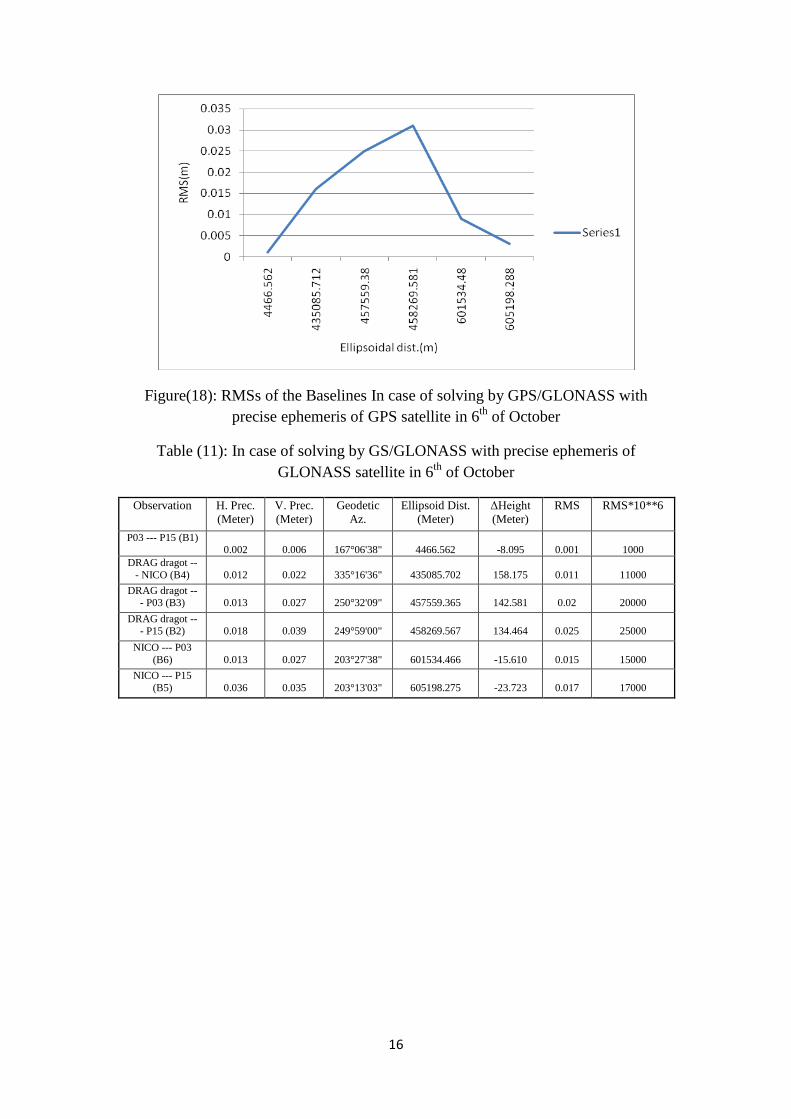
Figure(18): RMSs of the Baselines In case of solving by GPS/GLONASS with
precise ephemeris of GPS satellite in 6th
of October
Table (11): In case of solving by GS/GLONASS with precise ephemeris of
GLONASS satellite in 6th
of October
Observation H. Prec.
(Meter)
V. Prec.
(Meter)
Geodetic
Az.
Ellipsoid Dist.
(Meter)
ΔHeight
(Meter)
RMS RMS*10**6
P03 --- P15 (B1) 0.002
0.006
167°06'38"
4466.562
-8.095
0.001
1000
DRAG dragot --
- NICO (B4)
0.012
0.022
335°16'36"
435085.702
158.175
0.011
11000
DRAG dragot --- P03 (B3)
0.013
0.027
250°32'09"
457559.365
142.581
0.02
20000
DRAG dragot --- P15 (B2)
0.018
0.039
249°59'00"
458269.567
134.464
0.025
25000
NICO --- P03
(B6)
0.013
0.027
203°27'38"
601534.466
-15.610
0.015
15000
NICO --- P15
(B5)
0.036
0.035
203°13'03"
605198.275
-23.723
0.017
17000
17
Figure(19): RMSs of the Baselines In case of solving by GPS/GLONASS with precise
ephemeris of GLONASS satellite in 6th of October
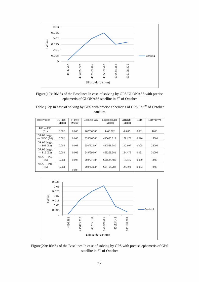
in 6th of October Table (12): In case of solving by GPS with precise ephemeris of GPS
satellite
Observation H. Prec.
(Meter)
V. Prec.
(Meter)
Geodetic Az. Ellipsoid Dist.
(Meter)
ΔHeight
(Meter)
RMS RMS*10**6
P03 --- P15 (B1)
0.002
0.006
167°06'38"
4466.562
-8.095
0.001
1000
DRAG dragot
--- NICO (B4)
0.002
0.005
335°16'36"
435085.712
158.173
0.016
16000
DRAG dragot
--- P03 (B3)
0.004
0.008
250°32'09"
457559.380
142.607
0.025
25000
DRAG dragot
--- P15 (B2)
0.004
0.009
249°59'00"
458269.581
134.479
0.031
31000
NICO --- P03 (B6)
0.003
0.008
203°27'38"
601534.480
-15.575
0.009
9000
NICO --- P15
(B5)
0.003
0.008
203°13'03"
605198.288
-23.690
0.003
3000
Figure(20): RMSs of the Baselines In case of solving by GPS with precise ephemeris of GPS
satellite in 6th of October
18
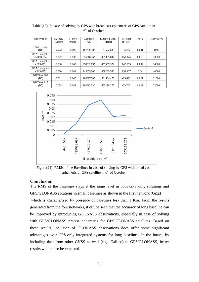
Table (13): In case of solving by GPS with broad cast ephemeris of GPS satellite in
6th of October
Observation H. Prec.
(Meter)
V. Prec.
(Meter)
Geodetic
Az.
Ellipsoid Dist.
(Meter)
ΔHeight
(Meter)
RMS RMS*10**6
P03 --- P15
(B1)
0.002
0.006
167°06'38"
4466.562
-8.095
0.001
1000
DRAG dragot --- NICO (B4)
0.022
0.033
335°16'36"
435085.697
158.174
0.013
13000
DRAG dragot --
- P03 (B3)
0.030
0.042
250°32'09"
457559.374
142.553
0.034
34000
DRAG dragot --
- P15 (B2)
0.028
0.044
249°59'00"
458269.568
134.437
0.04
40000
NICO --- P03
(B6)
0.031
0.040
203°27'38"
601534.470
-15.631
0.021
21000
NICO --- P15
(B5)
0.033
0.042
203°13'03"
605198.278
-23.742
0.022
22000
Figure(21): RMSs of the Baselines In case of solving by GPS with broad cast
ephemeris of GPS satellite in 6th of October
Conclusion The RMS of the baselines stays at the same level in both GPS only solutions and
GPS/GLONASS solutions in small baselines as shown in the first network (Giza)
which is characterized by presence of baselines less than 1 Km. From the results
generated from the four networks, it can be seen that the accuracy of long baseline can
be improved by introducing GLONASS observations, especially in case of solving
with GPS/GLONASS precise ephemeris for GPS/GLONASS satellites. Based on
these results, inclusion of GLONASS observations does offer some significant
advantages over GPS-only integrated systems for long baselines. In the future, by
including data from other GNSS as well (e.g., Galileo) to GPS/GLONASS, better
results would also be expected.

19
References
Blomenhofer H., Ehret W. & Blomenhofer E. (2004) Consideration of Operational
Outages in Galileo and GPS Integrity Analysis, The European Navigation Conference
GNSS 2004, Rotterdam, Netherlands, 81:1-12.
Bruyninx, C. (2007). Comparing GPS-only with GPS+GLONASS positioning in a
Regional Permanent GNSS Network. GPS Solution, 11:97-106, 2007.
Cross P.A., Hawksbee D.J., & Nicolai R. (1994) Quality measures for differential
GPS positioning, The Hydrographic Journal, Hydrographic Society, 72, 17-22.
GLONASS Interface and Control Document Version 5.0 (2002) Coordinational
Scientific Information Center, Russian Federation Ministry of Defence.
http://www.glonass-center.ru/public_e.html
Habrich, H. (1999). Geodetic Applications of the Global Navigation Satellite System
(GLONASS) and of GLONASS/GPS Combinations. PhD Thesis, University of
Berne.
Habrich, H., P. Neumaier, K. Fisch (2004). GLONASS Data Analysis for IGS.
Proceedings of IGS Workshop and Symposium, University of Berne, 2004.
Hall, T., Burke, B., Pratt, M., & Misra, P. (1997). Comparison of GPS+GLONASS
positioning performance. 10th Int. Tech. Meeting of the Satellite Division of the U.S.
Inst. of Navigation GPS ION'97, Kansas City, Missouri, 16-19 September, 1543-
1549.
Han, S., Dai, L., & Rizos, C. (1999). A new data processing strategy for combined
GPS/GLONASS carrier phase-based positioning. 12th Int. Tech. Meeting of the
Satellite Division of the U.S. Inst. of Navigation GPS ION'99, Nashville, Tennessee,
14-17 September, 1619-1628.
Kaplan, E.D., C.J. Hegart (2006). Understanding GPS: Principles and
Applications. 2nd Edition. Artech House. Sergey, K., R. Sergey, T. Suriya (2007).
GLONASS as a Key Element of the Russian Positioning Service.
Melgard, T., E. Vigen, K. de Jong, D. Lapucha, H. Visser, and O. Oerpen (2009)
“G2 - The First Real-Time GPS and GLONASS Precise Orbit and Clock Service,” in
Proceedings of ION GNSS 2009, 22-25 September,Savannah, Savannah OR, U.S.
Institute of Navigation, Fairfax VA

20
Weber, R., J.A. Slater, E. Fragner, V. Glotov, H. Habrich, I.Romero, S. Schaer
(2005). Precise GLONASS Orbit Determination within the IGS/IGLOS Pilot Project.
Advances in Space Research, 36: 369-375.
Zinoviev, A.E (2005).Using GLONASS in Combined GNSS Receivers: Current
Status. Proceedings of ION GNSS2005, Long Beach, CA, September 13-16, 2005.