imagine objective - geosystems · imagine objective includes an innovative set of tools for feature...
TRANSCRIPT

IMAGINE OBJECTIVETHE FUTURE OF FEATURE EXTRACTION, UPDATE, & CHANGE MAPPING
PRODUCT BROCHURE


IMAGINE OBJECTIVE ADDRESSING BUSINESS PROBLEMSGlobally, GIS departments and mapping institutions invest considerable revenue into creating and, perhaps more importantly, maintaining their geospatial databases. As the Earth is constantly changing, even the most precise base mapping must be updated or replaced regularly. Traditionally, the capture and update of geospatial information has been done through labor and cost intensive manual digitization (for example from aerial photographs) and post-production surveying. More accurate and complete information increases the value and ease of analysis. Remotely sensed imagery, whether airborne or satellite based, provides a rich source of timely information if it can be easily exploited into usable information. This transformation of data into tailored, relevant information provides benefits to a number of industries:
• Insurance companies can determine the presence or absence of swimming pools within land ownership parcels to correct liability insurance policies.
• Utility companies can identify and map the location of assets, such as man-hole covers, across a city-wide sewerage network. With assets installed over a long period of time, possibly by other companies, many utility companies have inaccurate or incomplete historical records.
• Local government institutions mapping urban growth (such as roads and buildings) can maintain a usable geospatial database for use by First Responders, tax departments, planners, etc. When disasters strike, the ability to rapidly identify the location of damaged houses or other infrastructure is critical to minimize the loss of life and aid in the recovery efforts
• Forest management companies can more accurately estimate species mix, yield potentials, and environmental impacts.
• Tax assessors can better map impervious surfaces and cross reference ownership parcels, increasing the accuracy of tax billing, and promoting better planning.
• State agencies can better manage water rights by mapping agricultural field boundaries and crop types.
IMAGINE Objective is offered within the PRODUCER SUITE of the Power Portfolio. The Producer Suite empowers you to collect, process, analyze and understand raw geospatial data, and ultimately deliver usable information. This includes Hexagon Geospatial’s desktop-based GIS, remote sensing, and photogrammetry offerings.
Remotely sensed imagery, whether airborne or satellite based, provides a rich source of timely information if it can be easily exploited into usable information.

AUTOMATING WORKFLOWSOriginally, workflows were done manually. Since then, various attempts have been made to help automate workflows analyzing remotely sensed imagery. These attempts have often resulted in limited success, especially as the resolution of imagery and the intended mapping scale increases. With recent innovations in geospatial technology, we are now at a place where workflows can be successfully automated.
When Landsat was launched more than 40 years ago, it was heralded as a new age for automating mapping of the Earth. However, the imagery, and therefore the geospatial data derived from it, was of relatively coarse resolution, and thereby became limited to smaller scale mapping applications. In addition, its analysis was restricted to “remote sensing experts.” Equally, the traditional supervised and unsupervised classification techniques developed to extract information from these types of imagery were limited to coarser resolutions.
Today’s sources for higher resolution imagery (primarily meaning 1m or smaller pixel sizes, such as that produced by the GeoEye, Pleiades, IKONOS, QuickBird, and WorldView satellites or by airborne sensors) do not suffer from the “mixed pixel” phenomenon seen with lower resolution
imagery, and, therefore the statistical assumptions that must be met for the traditional supervised and unsupervised classification techniques do not hold. Thus, more advanced techniques are required to analyze the high resolution imagery required to create and maintain large scale mapping and geospatial databases. The best techniques for addressing this problem analyze the imagery on an object, as opposed to pixel, basis.
INTUITIVE FEATURE EXTRACTION AND CLASSIFICATION TOOLSIMAGINE Objective includes an innovative set of tools for feature extraction, update and change detection, enabling geospatial data layers to be created and maintained through the use of remotely sensed imagery. This technology crosses the boundary of traditional image processing with computer vision through the use of pixel level and true object processing, ultimately emulating the human visual system of image interpretation.
Catering to both experts and novices alike, IMAGINE Objective contains a wide variety of powerful tools. For remote sensing and domain experts, IMAGINE Objective includes a desktop
Pixels(Training)
PIXELSINFERENCE
ENGINE
OBJECTINFERENCE
ENGINE
VectorObjects
(Training)
TRAIN QUERY
TRAIN QUERY
Pixels(Candidates)
VectorObjectLayer
VectorObjects
(Candidates)
PIXEL CUE METRICS
OBJECT CUE METRICS
Vector Objectto Vector
ObjectOperator
Prob. Pixelsto Raster
ObjectOperator
Vector Objectto Vector
ObjectOperator
PixelProbability
Layer
VectorProbability
Layer
Raster Objectto Raster
ObjectOperator
Raster Objectto Vector
ObjectOperator
RasterObjectLayer
VectorObjectLayer
VectorObjectLayer
RasterObjectLayer
IMAGINE Objective provides object based multi-scale image classification and feature extraction capabilities to reliably build and maintain accurate geospatial content. With IMAGINE Objective, imagery and geospatial data of all kinds can be analyzed to produce GIS-ready mapping.
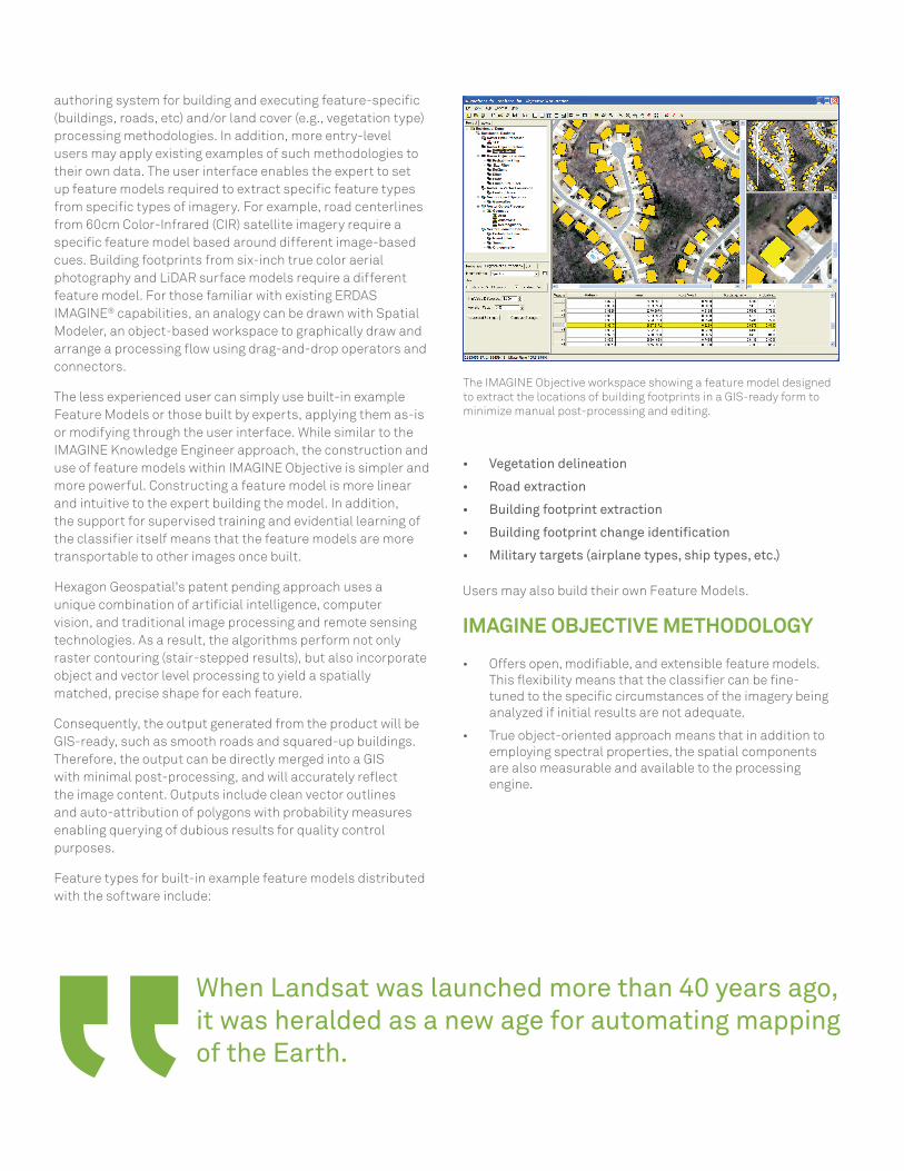
authoring system for building and executing feature-specific (buildings, roads, etc) and/or land cover (e.g., vegetation type) processing methodologies. In addition, more entry-level users may apply existing examples of such methodologies to their own data. The user interface enables the expert to set up feature models required to extract specific feature types from specific types of imagery. For example, road centerlines from 60cm Color-Infrared (CIR) satellite imagery require a specific feature model based around different image-based cues. Building footprints from six-inch true color aerial photography and LiDAR surface models require a different feature model. For those familiar with existing ERDAS IMAGINE® capabilities, an analogy can be drawn with Spatial Modeler, an object-based workspace to graphically draw and arrange a processing flow using drag-and-drop operators and connectors.
The less experienced user can simply use built-in example Feature Models or those built by experts, applying them as-is or modifying through the user interface. While similar to the IMAGINE Knowledge Engineer approach, the construction and use of feature models within IMAGINE Objective is simpler and more powerful. Constructing a feature model is more linear and intuitive to the expert building the model. In addition, the support for supervised training and evidential learning of the classifier itself means that the feature models are more transportable to other images once built.
Hexagon Geospatial's patent pending approach uses a unique combination of artificial intelligence, computer vision, and traditional image processing and remote sensing technologies. As a result, the algorithms perform not only raster contouring (stair-stepped results), but also incorporate object and vector level processing to yield a spatially matched, precise shape for each feature.
Consequently, the output generated from the product will be GIS-ready, such as smooth roads and squared-up buildings. Therefore, the output can be directly merged into a GIS with minimal post-processing, and will accurately reflect the image content. Outputs include clean vector outlines and auto-attribution of polygons with probability measures enabling querying of dubious results for quality control purposes.
Feature types for built-in example feature models distributed with the software include:
When Landsat was launched more than 40 years ago, it was heralded as a new age for automating mapping of the Earth.
The IMAGINE Objective workspace showing a feature model designed to extract the locations of building footprints in a GIS-ready form to minimize manual post-processing and editing.
• Vegetation delineation
• Road extraction
• Building footprint extraction
• Building footprint change identification
• Military targets (airplane types, ship types, etc.)
Users may also build their own Feature Models.
IMAGINE OBJECTIVE METHODOLOGY
• Offers open, modifiable, and extensible feature models. This flexibility means that the classifier can be fine-tuned to the specific circumstances of the imagery being analyzed if initial results are not adequate.
• True object-oriented approach means that in addition to employing spectral properties, the spatial components are also measurable and available to the processing engine.

• Caters to discrete feature extraction (e.g. where are the buildings) and multi-class extractions (wall to wall classification), providing a flexible tool for a variety of problem scenarios.
• Provides discrete feature extraction, where clean-up operators can be included in the feature model to produce output suitable for merging into a GIS with minimal post-processing (squared-up buildings, smooth gap-less roads, aircraft outlines, etc).
• Integrates with ERDAS IMAGINE, providing a full suite of vector editing tools for further clean-up and editing. This integration provides an end-to-end feature extraction process within one integrated package. Other workflows often require steps to be performed in different software packages, with the inherent capability for losing information and efficiency.
• Uses ancillary layers (data fusion) – e.g. slope, aspect, LiDAR, texture, etc. – along with the capability inherent with an object based approach to employ shape metrics, proximity, association, thereby leading to increased feature extraction accuracy.
• Leverages holdings of all remotely sensed imagery, including panchromatic, multispectral, hyperspectral, SAR, LiDAR, etc.
• Extracts features and classes that are attributed based on the measures used to identify them, including a final probability of being in that class, enabling quicker validation of final results and analysis of problem areas. The IMAGINE Objective workspace showing a feature model designed
to identify the locations of a particular aircraft type.
IMAGINE Objective includes an innovative set of tools for feature extraction, update and change detection, enabling geospatial data layers to be created and maintained through the use of remotely sensed imagery.
• Provides the ability to prototype and test a new feature model on user-selected view windows (even if the training evidence lies outside the area to be processed) for rapid fine-tuning and applying the finished feature model to the whole data set (or to different data sets).
• Deploys floating licenses as standard, ensuring that maximum usage of the software can be made across an institution’s network.

ABOUT POWER PORTFOLIOThe Power Portfolio from Hexagon Geospatial combines the best photogrammetry, remote sensing, GIS and cartography technologies available. Flowing seamlessly
from the desktop to server-based solutions, these technologies specialize in data organization, automated geoprocessing, spatial data infrastructure, workflow
optimization, web editing, and web mapping.
The Producer Suite enables you to intelligently author, analyze, process, and map multiple sources of data.
ABOUT HEXAGON GEOSPATIALHexagon Geospatial helps you make sense of the dynamically changing world. Known globally as a maker of leading-edge technology, we enable our customers to easily
transform their data into actionable information, shortening the lifecycle from the moment of change to action. Hexagon Geospatial provides the software products and
platforms to a large variety of customers through direct sales, channel partners, and Hexagon businesses. For more information, visit www.hexagongeospatial.com
or contact us at [email protected].
Hexagon Geospatial is part of Hexagon, a leading global provider of information technologies that drive quality and productivity improvements across geospatial
and industrial enterprise applications. Hexagon’s solutions integrate sensors, software, domain knowledge and customer workflows into intelligent information
ecosystems that deliver actionable information, automate business processes and improve productivity. They are used in a broad range of vital industries.
Hexagon (Nasdaq Stockholm: HEXA B) has more than 15,000 employees in 46 countries and net sales of approximately 3.1bn USD. Learn more at hexagon.com.
© 2016 Hexagon AB and/or its subsidiaries and affiliates. All rights reserved. Hexagon and the Hexagon logo are registered trademarks of Hexagon AB or its subsidiaries. All other trademarks or servicemarks used herein are property of their respective owners. Hexagon Geospatial believes the information in this publication is accurate as of its publication date. Such information is subject to change without notice.
POWER PORTFOLIO PRODUCT & INTERACTION
PRODUCER SUITE
Link to a GeoMedia environment from the ERDAS IMAGINE interface to synchronize navigation and Area of Interest.
Enhance Imagery in ERDAS IMAGINE before bringing it into IMAGINE Objective.
Raster imagery using the ultra-fast ECW compression format may be directly consumed in ERDAS IMAGINE.
Output vector or raster files from your IMAGINE Objective results into any GIS-ready platform like GeoMedia
Enhance Imagery in ERDAS IMAGINE before publishing to GeoMedia WebMap.
PROVIDER SUITE
Publish your results from IMAGINE Objective to ERDAS APOLLO and deliver over the Internet as server-side geoprocesses (WPS).
Raster backdrops can be streamed, using the ultra-fast ECWP streaming protocol, by ERDAS APOLLO.
GEOSYSTEMS GmbHRiesstraße 10 | D-82110 GermeringT: +49 89 894343-0 | F: +49 89 [email protected] | www.geosystems.de
KONTAKT: