image web server product description - planetek.it · er mapper image web server is a...
TRANSCRIPT

ww
w.e
rma
pp
er.c
om
Image Web Server
Product Description
Contents
Introduction 3
What is Image Web Server? 4
Where is Image Web Server used? 4
Why a specialist solution for serving geospatial images? 4
What types of images can Image Web Server deliver? 5
Image Web Server architecture 5
How does ER Mapper’s Image Web Server differ from other solutions? 6
Image Web Server fi le formats 6
Image compression 6
ECW vs JPEG 2000 formats 7
Lossy vs. Lossless imagery compression 7
When to use lossy or lossless data 8
Image Web Server is compatible with your existing infrastructure 8
Multi-protocol support in Image Web Server 8
Real-time roam and zoom 9
Multiple data layers in a single view 9
How Image Web Server secures your data 10
Accessing imagery from an Image Web Server 11
Accelerating your WebGIS with Image Web Server 11
Web Map Framework: enhance your WebGIS 13
Image Web Server Platform 14
Supporting Products from ER Mapper 14
System Requirements 15

page 3
IntroductionIn recent years, there has been a huge increase in the demand for geospatial imagery (airphotos, satellite images, radar images, geophysical images, etc). This demand has been driven by increased availability, decreased costs, and an increasingly widespread awareness of the benefi ts associated with using imagery.
Image Web Server, with its high-performance, multi-protocol design is the ideal solution for any organization wanting to use the internet (or an intranet) to make large images available to desktop, web, server and mobile applications.
page 4
What is Image Web Server?ER Mapper Image Web Server is a high-performance, specialised server application that delivers imagery to desktop, web, server and mobile applications.
Image Web Server is able to deliver very large raster images even over networks with relatively low bandwidths. This makes Image Web Server particularly suited for the Internet, where congestion and slow links can compromise performance with more traditional image serving techniques.
Where is Image Web Server used?Image Web Server is used in a wide range of industry sectors such as local, state, and federal governments, telecommunications companies, land information agencies, utilities such as power and water, environmental groups and defense departments.
A small sample of Image Web Server customers includes:
US Border PatrolMelbourne WaterTaiwan Ministry of Interior Italian Environmental Protection AgencyDoncaster Metropolitan Borough Council Michigan Groundwater Management ProjectLee County, USA, Property Appraiser’s Offi ce Department of Lands, New South Wales, Australia
Why a specialist solution for serving geospatial images?Geospatial images are unlike other types of data. Their size is typically measured in hundreds of gigabytes or even terabytes.
The size of imagery is increasing as acquisition technology matures and the resolution of images becomes increasingly fi ne. For example, with modern digital cameras, airphoto suppliers can generate over a terabyte of data with just a single fl ight sortie.
Furthermore, organizations are fi nding that the number of image datasets they need to manage is increasing, due to the wider range of sensors available and the desire to store data for the same area for different years (or even months) for comparison purposes.
Effectively managing these images and ensuring that they are available to all users who need them is a challenge that is impossible to meet without employing specialist image serving software.
••••••••
Image Web Server is a high performance server application that delivers imagery to web, mobile and desktop applications
Images are so large, they require a specialist solution to use them effectively
Image Web Server is used by organizations like yours throughout the world
page 5
What types of images can Image Web Server deliver?You can use Image Web Server to serve many different types of 2D and 3D images including high-resolution satellite, radar and radiometric images, aerial photography, seismic horizons, digital terrain models, as well as any other type of digital data stored in raster format.
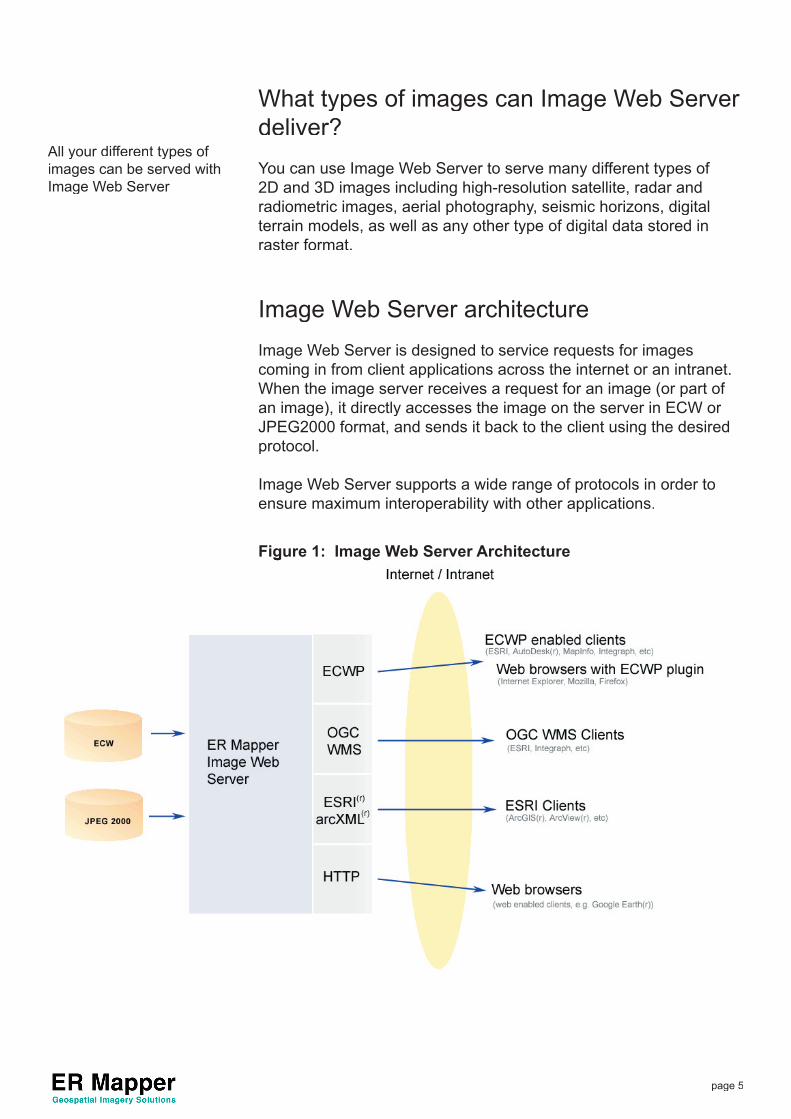
Image Web Server architectureImage Web Server is designed to service requests for images coming in from client applications across the internet or an intranet. When the image server receives a request for an image (or part of an image), it directly accesses the image on the server in ECW or JPEG2000 format, and sends it back to the client using the desired protocol.
Image Web Server supports a wide range of protocols in order to ensure maximum interoperability with other applications.
Figure 1: Image Web Server ArchitectureFigure 1: Image Web Server Architecture
All your different types of images can be served with Image Web Server
page 6
How does ER Mapper’s Image Web Server differ from other solutions?Most other image serving technologies rely on using a geo-database to store uncompressed image data. Geo-databases are typically used to distribute attribute (vector) data and have been modifi ed to provide raster / image serving capabilities.
It is important to note, that the problems associated with serving vector datasets are very different to those associated with serving raster datasets. One gigabyte may be considered a large vector dataset, but is considered small for a raster image.
Conversely, Image Web Server is a purpose built image serving solution designed specifi cally for handling large raster datasets.
Image Web Server does not require a database, instead reading image data directly. By removing the database component from the equation, we both simplify the setup process, and make the serving processes faster and more effi cient.
Image Web Server fi le formatsImage Web Server serves imagery that is stored in either the ECW or JPEG 2000 compressed image formats.
The ECW format was developed by ER Mapper and is the most popular compressed geospatial imagery format in the world. JPEG 2000 is an ISO format developed by the Joint Photographic Experts Group.
Data in other formats (such as geoTiff) can easily be converted to ECW or JPEG 2000 format using ER Mapper Professional, a desktop image processing and compression application.
The ECW and JPEG 2000 formats inherent architecture make them ideal for image serving.
Image compressionCompression reduces the total fi le size of the image, while retaining its original quality. Using complex mathematical processes reduces the fi le size of the image.
Compressed images can be just 5% of the original size of imagery whilst visually looking the same as the original uncompressed data.
Compression results in faster access to imagery datasets as well as greater portability, either via CD or DVD distribution, or over
ECW and JPEG 2000 formats are ideally suited for geospatial imagery serving
ECW is the most popular compressed format for geospatial images
Image compression simplifi es data management and speeds up access to the image data
Image Web Server doesn’t require a third-party database solution
page 7
networks or the Internet.
The most effective form of image compression today is wavelet based image encoding. Wavelet compression analyzes an uncompressed image recursively. This analysis produces a series of sequentially higher resolution images, each augmenting the information in the lower resolution images.
Wavelet compression is very effective at retaining data accuracy within highly compressed fi les. Unlike JPEG, which uses a block-based Discrete Cosine Transformation (DCT) on blocks across the image, modern wavelet compression techniques enable compressions of 20:1 or greater without visible degradation of the original image. Wavelet compression can also be used to generate lossless compressed imagery, at ratios of around 4:1.
ECW vs JPEG 2000 formatsFactors to consider when choosing a format:
Size: Datasets larger than 1,000 gigabytes should be compressed with ECW
Performance: Compression and decompression will generally be quicker with ECW images.
Bit Depth: ECW only support 8-bits data per band (24-bit RGB) where as JPEG 2000 supports up to 28-bit precision per band.
Compatibility: ECW is more widely supported in GIS applications than the new JPEG 2000 format. JPEG 2000 support is growing rapidly.
Lossy or Lossless:
ECW only supports lossy compression. JPEG 2000 supports lossy and lossless compression.
Lossy vs. Lossless imagery compressionLossy compression sacrifi ces some of the precision of the original data in order to get a higher degree of compression. In other words you “lose” data as part of the compression process. However this “lost” data usually isn’t visually noticeable up to a compression ratio of about 20:1 (This can vary with the image and the level of detail that will typically be examined).
Lossy data can achieve a compression ratio of approximately 20:1 without any visual degradation, whereas the average lossless compression only achieves a 4:1 compression ratio.
page 8
You can use Image Web Server in desktop, web, mobile and server applications
When to use lossy or lossless dataMost, 80 – 90%, of geospatial imagery applications are suitable for using lossy imagery. Anything that requires a human, visual analysis is appropriate for lossy-based compression. For example, integrations of aerial or satellite photography with a WebGIS should use a lossy compression method.
Lossless based imagery is necessary for scientifi c based image processing where pixel-for-pixel fi delity is required. Many of the processes undertaken by geologists require lossless imagery types.
Image Web Server is compatible with your existing infrastructureImage Web Server is compatible with all common desktop, web and server applications. For example, Image Web Server has easy integration paths for users of ArcGIS®, MapInfo®, ArcIMS® and ® and ®Microsoft Word® to name but a few applications.® to name but a few applications.®
Image Web Server enables this compatibility by supporting many different image serving protocols.
Multi-protocol support in Image Web ServerA protocol can be thought of as a language for communicating to different applications.
Image Web Server supports the fi ve major image serving protocols.
OGC WMS The Open GIS Consortium is a worldwide collection of member companies who provide guidance and develop specifi cations for the geospatial industry. Image Web Server (version 2.0 onwards) supports the WMS 1.1.1 specifi cation
ESRI’s ArcXML® Image Web Server can ‘masquerade’ as an ESRI ArcIMS server. This makes Image Web Server drop-in plug compatible with the ESRI ArcIMS Server and an ESRI desktop environment.
For most applications, lossy compression is the appropriate choice

page 9
ECWP Streaming ECWP Streaming is the fastest way of accessing large imagery datasets. The ECWP protocol transfers compressed blocks from the server to the client, providing real-time roam and zoom functionality on image updates
Many applications natively support ER Mapper’s streaming imagery protocol.
As well as this, ER Mapper supplies free plug-ins for Internet Explorer and Netscape browsers as well as several major imaging packages to enable streaming ECWP access.
ImageX A simple interface developed by ER Mapper A simple interface developed by ER Mapper Ato provide JPEG and PNG image subsets from ECW and JPEG 2000 fi les, and is used for effi ciently extracting a JPEG for a defi ned set of map extents. The ImageX protocol is called by simple HTTP requests.
Google Earth™ KML
This is the XML schema used by Google Earth to access different data stores. With Image Web Server, you can easily add your own image data to a Google Earth Application.
All protocols run in parallel from the same Image Web Server allowing the same image to be served using whatever interface best suits the users’ application.
Real-time roam and zoomZoom easily to any area at any resolution. Real-time roam and zoom lets you effi ciently view the area you need – without the painstakingly slow “click-and-wait” operations of other systems.
Real time roam and zoom lets you make adjustments to your viewing area without waiting for the full dataset to be loaded. This gets your job done quicker and saves you valuable time.
Multiple data layers in a single viewImage Web Server allows you to stack multple data layers on top of each other. You can then use transparency options to create the ideal view.
page 10
Highlight temporally distinct data
View a 2005 image, over a 2002 image. Using transparency you can clearly identify any change. What new building have constructed? How has the environment changed?
View different web services
Use Image Web Server’s “layered view” capability to bring in multiple GIS servers. Use transparency options to create a unique data view.
How Image Web Server secures your data
Image Web Server provides advanced security functionality to en-sure full lock-down of your imagery assets.
Image Web Server can restrict access to:
An image or group of images; A specifi ed region within an image; orA particular resolution
Access to your imagery can be restricted based on:
1. Network domain based securitySecure your imagery based on user / domain records in the servers operating system.
2. External database of users / permissionsImage Web Server can query a users credentials against the access control listing in an external database. Image Web Server comes complete with an Advanced Security Authentication Web Service that interacts with the database.
3. Client-encryption keyOnly provide access to users with an authorized client-side encryp-tion key.
4. IP Address / Location and other restrictive methodsImage Web Server inherits the security modules of the operationalweb server (e.g. Windows IIS). Using the features of these web servers Image Web Server is able to block users based on their IP address and location. Other security features are also available as documented by the particular web server.
Secure encryption of transmitted image data
Image Web Server can distribute imagery using an SSL-based encryption. ECWPS (streaming secure imagery) can serve your
•••
Robust, fl exible security options totally lock-down your valuable data
page 11
Accessing imagery from Image Web Server is practically identical to your current methods
image data to users in 40-256bit based encryption.
Accessing imagery from an Image Web ServerImagery from Image Web Server can be accessed from desktop, web and server applications.
Desktop applications (streaming):
Using desktop applications to access Image Web Server is as simple as opening a fi le. However, instead of a fi le location, you put in an ECWP url, such as:
ecwp://yourWebSite/images/yourimage.ecw
Desktop applications (ArcXML or OGC WMS)To access Image Web Server via ArcXML or OGC WMS, you would simply register your Image Web Server url as a service within the application. You would then interact with your Image Web Server as though it were a native ArcIMS / OGC WMS service.
Web Applications
Merely point your web browser to your Image Web Server pages.
Image Web Server compliant pages are created using Image Web Server’s open client development platform. These pages can be customized to fully suit your requirements.
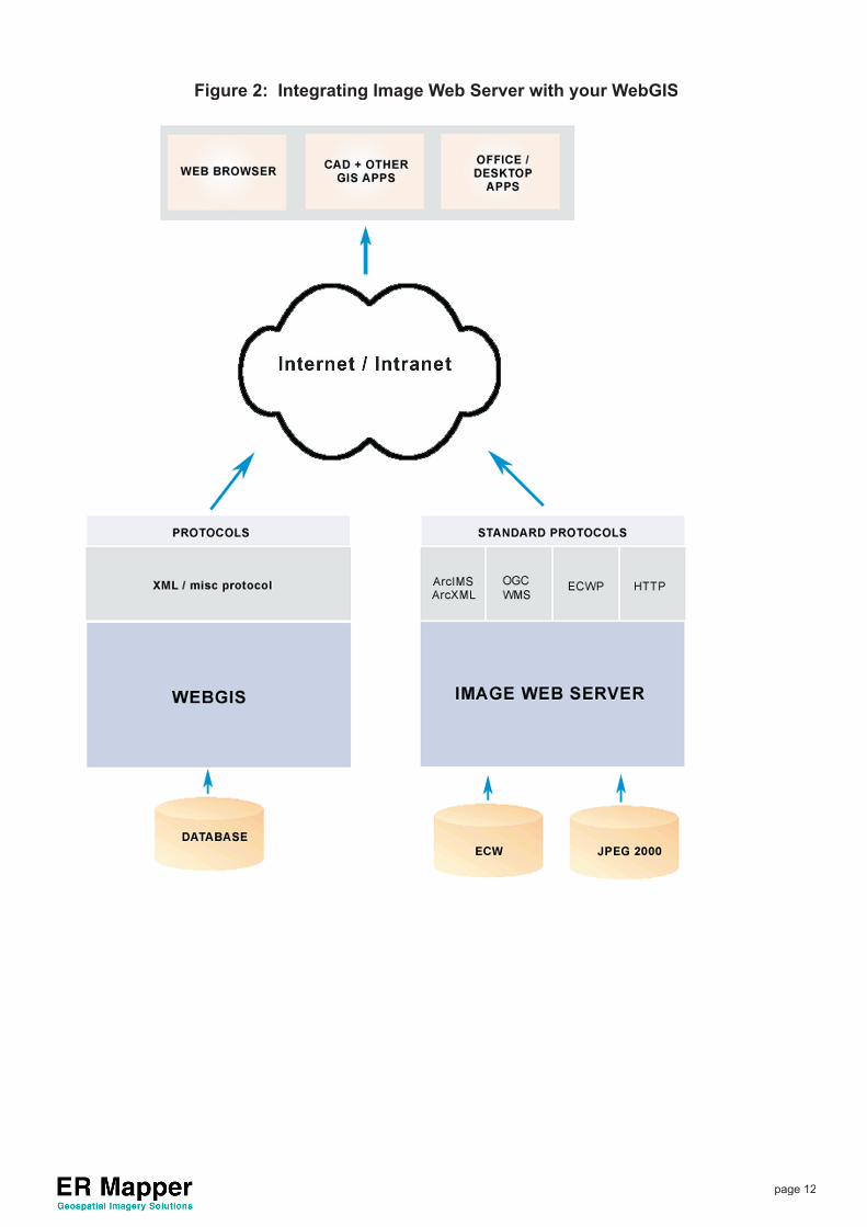
Accelerating your WebGIS with Image Web Server
Image Web Server turbo-charges your WebGIS. Serving imagery places a huge load on WebGIS servers. Give your organisation a boost and let the purpose built Image Web Server deploy your image data, freeing your Web GIS to serve attribute / vector data.
Image Web Server is more effi cient at serving large geospatial images than database-centric image serving solutions.
The key reasons why Image Web Server outperforms database-centric solutions are:
Image Web Server accesses imagery directly from the fi le system and therefore does not incurr a database engine overhead. Image Web Server is purpose built for effi cient large image
•
•
Image Web Server takes the heavy-load of your image data, leaving your WebGIS to concentrate on serving attribute data
page 12
Figure 2: Integrating Image Web Server with your WebGIS
page 13
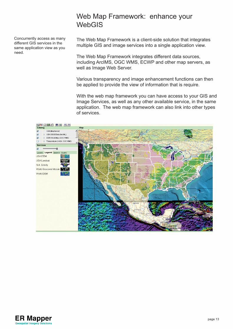
Web Map Framework: enhance your WebGIS
The Web Map Framework is a client-side solution that integrates multiple GIS and image services into a single application view.
The Web Map Framework integrates different data sources, including ArcIMS, OGC WMS, ECWP and other map servers, as well as Image Web Server.
Various transparency and image enhancement functions can then be applied to provide the view of information that is require.
With the web map framework you can have access to your GIS and Image Services, as well as any other available service, in the same application. The web map framework can also link into other types of services.
Concurrently access as many different GIS services in the same application view as you need.

page 14
Image Web Server PlatformImage Web Server is installed on top of a web server application. Currently Image Web Serve can run on:
Microsoft IIS 4 / 5 / 6Apache under Solaris (scheduled for release 2nd half of 2006)
If you have another operating system requirement, please contact
you nearest ER Mapper Offi ce.
Supporting Products from ER Mapper In addition to providing Image Web Server as a image serving product, and ER Mapper Web Map Framework as an enterprise-level integration tool, ER Mapper provides other key software to help prepare and use your imagery.
ER Mapper Mosaic-Balance-Compression (MBC)
This wizard-driven software easily creates seamless, color-balanced and compressed image mosaics from your imagery. The ECW and JPEG 2000 fi les you create with ER Mapper MBC can be served with your Image Web Server.
ER Mapper Professional
ER Mapper is a powerful image-processing tool for aerial photographs, satellite imagery and other remotely sensed data. It helps you complete the most complicated tasks with the click of a few buttons. ER Mapper is widely used to enhance and process imagery for use in GIS, CAD, imaging, offi ce and web applications.
ECW and JPEG 2000 Compression SDK
Once you have prepared your imagery using ER Mapper, you can compress it using the highly effi cient ECW or JPEG 2000 compression formats and have the images ready to be served using the Image Web Server via any of the supported protocols. The ECW compressed image format is the popular standard for compressing and using very large images. JPEG 2000 is a new, international standard developed by the Joint Photographic Experts Group (JPEG).
ER Mapper Web Map Framework
This product provides an effi cient, quick-deployment, enterprise-scale integration environment for your organisation.The Web Map Framework is a client-side solution that integrates multiple GIS and image services into a single application view. It integrates different data sources, including ArcIMS, OGC WMS, ECWP and other map servers.
••
page 15
System RequirementsHardware
The hardware requirements depend on the size and amount of the images being served. The following are suggested guidelines:
If you are serving smaller images (less than 100 GB uncompressed) to a limited number of users (less than 500 users), then just about any PC with a reasonable amount of RAM (say 64MB to 128MB) will suffi ce.
Use a PC with 256MB of RAM to serve images up to 200 GB in size. If you plan to serve TB (1,000 GB) size images, use a PC with at least 1 GB of RAM. This will speed up caching considerably.
The limiting factor for the Image Web Server performance is the Internet connection speed. Unless you have a very high speed Internet connection, a standard single-CPU machine will provide good performance. If you use a dual-CPU PC to serve your imagery, the Image Web Server will take advantage of the multiple processors to optimize performance.
RAID (Redundant Array of Inexpensive Disks) 5 striping enables you to confi gure a set of disk drives as one or more logical drives. Data is distributed across the set of drives in a defi ned manner, with redundant capacity added to recover data in the event of a disk failure. RAID 5 adds parity to the array, reducing total disk space by the amount of one drive. With RAID 5, one drive can fail and the RAID system can still be reconstructed.
For RAID based systems we recommend that you provide a separate boot/ system drive to store the operating system, utilities and swap fi le, with the image data and web site pages being stored on the RAID drive array.
Example Hardware Confi guration
This is an example of a web server that is designed to serve over 1 TB of imagery, to thousands of users simultaneously.
CPUs: 2 x Intel® Xeon™ at 2.8Ghz
RAM: 1 GB 266 MHz DDR SDRAM
Disks: 4 x 120GB EIDE ULTRA ATA100 hard disks (480GB total)
Software: Windows 2000 / 2003 Server (includes IIS 5 /6)
•
•
•
•
•
page 16
Server OS Software
For Windows Servers:
The host PC will need to be running:
Windows NT 4.0 Server (SP6); orWindows 2000 Server (SP4); orWindows 2003 Server(SP1)IIS version 4.0 or higher.Internet Explorer 5.x or higher. This is required because ‘ecw_img.dll’, used by the server to stream JPEG images to the client browser, needs ‘wininet.dll v5’ to work.
Supported Web Browsers
Any browser can be used to access data stored on image web server.
However, the functionality available to the end-user will vary depend-ing on the browser. Particular features are reliant on the browser having access to a version of Javascript later than 1.2 and a DOM in-line with that outlined by the WWW consortium.
Streaming imagery access via a web browser:
To access streaming imagery, clients must be running Internet Ex-plorer® version 5 or above, Netscape Navigator® version 7.0 or above and Mozilla 1.4. ER Mapper no longer supports Netscape 4.x though the plug-in for that version is still provided.
Clients running on Unix machines (including Linux / Solaris) and using Mozilla 1.0/Netscape 6.2/ Firefox 1.0 or higher with Sun Java Plug-in v1.4 will also be able to access the server using a java ap-plet.
•••••

page 17
Trademarks
ESRI, ArcView, ArcInfo, ArcGIS, ArcSDE, ArcIMS, ArcXML and ArcEditor are registered trademarks of Environmental Systems Research Institute, Inc.
AutoCAD, AutoCAD Map, Autodesk and Autodesk World are registered trademarks of Autodesk.
MapInfo is a registered trademark of MapInfo Corporation.
Microsoft, Microsoft Offi ce, Microsoft Word, Microsoft Excel, Microsoft Internet Explorer and Windows are registered trademarks of Microsoft.