illinois route 47 from u.s. route 14 to charles road
TRANSCRIPT

COMBINED DESIGN REPORT
ILLINOIS ROUTE 47
FROM
U.S. ROUTE 14 TO CHARLES ROAD
P-91-007-09
McHenry County, Illinois
IDOT–Office of Highways Project ImplementationDistrict One
April 2019VOLUME 1–REPORT


Contact Information
Job Number: P-91-007-09
Project: Reconstruction and widening of Illinois Route 47 from US Route 14 to Charles Road
Location: Woodstock, IL
IDOT Unit Head: Kimberly Murphy, P.E.
Phone: 847-705-4791
Email: [email protected]
IDOT Manager: Corey Smith, P.E.
Phone: 847-705-4103
Email: [email protected]
IDOT Engineer: Kyle Bochte
Phone: 847-705-4678
Email: [email protected]
Consultant:
PTB 149/008 Firm: Strand Associates, Inc.®
Project Manager: Darcie Gabrisko, P.E.
Phone: 815-744-4200
Email: [email protected]

TABLE OF CONTENTS
VOLUME 1–REPORTPage No. or Following
SECTION 1–NEED FOR IMPROVEMENT
1.1 Project Location and Termini............................................................................................. 21.2 Description of Existing Conditions ..................................................................................... 2
1.2.1 Typical Section .................................................................................................... 31.2.2 Major Intersections .............................................................................................. 31.2.3 Land Use ............................................................................................................ 131.2.4 Environmental Resources ................................................................................... 141.2.5 Public Facilities and Services .............................................................................. 141.2.6 Existing Drainage ................................................................................................ 15
1.3 Operational and Safety Analyses, Identified Deficiencies .................................................. 151.3.1 Project History ..................................................................................................... 151.3.2 Identified Deficiencies .......................................................................................... 16
1.4 Project Purpose ................................................................................................................ 24
SECTION 2–ALTERNATIVE ANALYSIS
2.1 Design Criteria and Alternatives Development Process .................................................... 262.2 Alternatives Considered .................................................................................................... 282.3 Further Evaluation of Existing Alignment Alternative ......................................................... 32
2.3.1 Median Selection–US 14 to Ware Road ............................................................... 322.3.2 Intersection Alternatives ....................................................................................... 322.3.3 Detailed Alignments–US 14 to Ware Road........................................................... 332.3.4 Alternatives From Ware Road to Charles Road.................................................... 33
SECTION 3–DESCRIPTION OF PROPOSED IMPROVEMENTS
3.1 Introduction ....................................................................................................................... 353.2 Design Criteria Utilized...................................................................................................... 353.3 Geometric Improvements .................................................................................................. 353.4 Pavement Drainage .......................................................................................................... 363.5 Design Exceptions ............................................................................................................ 363.6 Right-of-Way ..................................................................................................................... 363.7 Structures ......................................................................................................................... 373.8 Traffic Signal Modernization/Installation and Roundabouts ............................................... 383.9 Lighting ............................................................................................................................ 423.10 Parking ............................................................................................................................ 433.11 Bicyclists and Pedestrians ................................................................................................ 453.12 Mass Transportation ......................................................................................................... 453.13 Utility Conflicts .................................................................................................................. 463.14 Encroachments ................................................................................................................. 463.15 Mail Drop-Off .................................................................................................................... 463.16 Landscape/Roadside Development................................................................................... 463.17 Lift Stations ....................................................................................................................... 473.18 Retaining Walls ................................................................................................................. 473.19 Other ............................................................................................................................ 473.20 Environmental Resources ................................................................................................. 473.21 Erosion and Sediment Control .......................................................................................... 483.22 Traffic Management Plan .................................................................................................. 50
3.22.1 IL 47–US 14 to Ware Road .................................................................................. 50

3.22.2 IL 47–Ware Road to Charles Road ...................................................................... 513.22.3 IL 47–Roundabout MOT....................................................................................... 52
3.23 Transportation Operations Plan ........................................................................................ 523.24 Public Information Plan ..................................................................................................... 523.25 Public Involvement ............................................................................................................ 53
3.25.1 Corridor Advisory Group ...................................................................................... 543.25.2 Public Meetings.................................................................................................... 553.25.3 Business Meetings ............................................................................................... 563.25.4 Public Hearing ..................................................................................................... 56
3.26 Value Engineering Study ................................................................................................... 57
SECTION 4–COMMITMENTS
4.1 Commitments .................................................................................................................... 59
SECTION 5–SPECIAL DESIGN AND CONSTRUCTION CONSIDERATIONS
5.1 Special Design and Construction Considerations .............................................................. 61
SECTION 6–CONSTRUCTION COST ESTIMATE
Construction Cost Estimate ......................................................................................................... 63
TABLES
1.2-1 Illinois Route 47 and US Route 14 Intersection Data ......................................................... 41.2-2 Illinois Route 47 and Lake Avenue Intersection Data ........................................................ 51.2-3 Illinois Route 47 and McConnell Road Intersection Data ................................................... 61.2-4 Illinois Route 47 and Country Club Road Intersection Data ............................................... 71.2-5 Illinois Route 47 and Judd Street/Irving Avenue Intersection Data .................................... 81.2-6 Illinois Route 47 and IL 120 Intersection Data ................................................................... 91.2-7 Illinois Route 47 and St. Johns Road Intersection Data ..................................................... 101.2-8 Illinois Route 47 and Russel Court Intersection Data ........................................................ 111.2-9 Illinois Route 47 and Ware Road Intersection Data ........................................................... 121.2-10 Illinois Route 47 and Charles Road Intersection Data ....................................................... 131.3-1 AM and PM 2009 and Future No-Build (2040) Level of Service and
Delay by Intersection...................................................................................................... 21
2.1-1 Illinois Route 47 Geometric Design Criteria ....................................................................... 262.2-1 Full Range of Alternatives Description .............................................................................. 302.2-2 Impacts Summary Table ................................................................................................... 31
3.10-1 Impacted Parking Spaces ................................................................................................. 443.20-1 Environmental Resource Impacts ..................................................................................... 48
6.01-1 Preliminary Cost Estimate ................................................................................................. 63

FIGURES
1.2-1 Illinois Route 47 Urban SRA ............................................................................................... 21.2-2 Illinois Route 47 Rural SRA ................................................................................................. 21.2-3 Existing Typical Section ...................................................................................................... 31.3-1 Total Crashes 2010 to 2014 ................................................................................................ 161.3-2 2010 to 2014 Crash Types .................................................................................................. 171.3-3 Injury Crashes 2010 to 2014 ............................................................................................... 181.3-4 Level of Service .................................................................................................................. 191.3-5 2009 and Projected 2040 Future No Build ADT and LOS .................................................... 201.3-6 Access Management Reduces Conflict Points .................................................................... 221.3-7 Incomplete Facilities Make Pedestrian Travel Difficult ......................................................... 221.3-8 Skewed Intersections .......................................................................................................... 231.3-9 Geometric and Design Deficiencies .................................................................................... 23
2.1-1 Existing Speed Limit and Proposed Design Speed Map...................................................... 272.2-1 Illinois Route 47 Full Range of Alternatives with Environmental Resources ........................ 29
3.8-1 Lake Avenue and McConnell Road Roundabouts ............................................................... 393.8-2 Judd Street/Irving Avenue Roundabout ............................................................................... 403.8-3 Ware Road Roundabout ..................................................................................................... 413.8-4 Charles Road Roundabout .................................................................................................. 42

VOLUME 2–EXHIBITS Location Map Exhibit 1.1-1 Existing Conditions (Environmental Survey Request) Exhibit 1.2-1 Existing Typical Sections Exhibit 1.2-2 Existing Pedestrian Facilities Exhibit 1.2-3 City of Woodstock Land Use Map Exhibit 1.2-4 Typical Section Alternatives–Ware Road to Charles Road Exhibit 2.3-1 Proposed Typical Sections Exhibit 3.3-1 Proposed Conditions (Plan and Profile) Exhibit 3.3-2 Design Exception Summary Table Exhibit 3.5-1 Intersection Design Studies Exhibit 3.8-1 Maintenance of Traffic Typical Sections Exhibit 3.22-1 VOLUME 3–APPENDIX A APPENDIX A–AGENCY COORDINATION Environmental Coordination Appendix A-1 Cultural Biological Wetlands Special Waste Air Quality Noise FHWA Coordination Appendix A-2 CMAP Coordination Appendix A-3 Legislative Coordination Appendix A-4 Municipal Coordination Appendix A-5 McHenry County Coordination Appendix A-6 PACE Bus Coordination Appendix A-7 Union Pacific Railroad Coordination Appendix A-8 IDOT Coordination Appendix A-9 VOLUME 4– APPENDIX B APPENDIX B–PUBLIC INVOLVEMENT Public Hearing Appendix B-1 Public Meetings Appendix B-2 CAG Meetings Appendix B-3 Miscellaneous Meetings Appendix B-4 Other Public Correspondence Appendix B-5

SUPPLEMENTS
Environmental Assessment Supplement 1.2-1Environmental Assessment Errata Supplement 1.2-2Finding of No Significant Impact Supplement 1.2-3Soil Survey Supplement 1.2-4Crash Analysis Supplement 1.3-1Bicyclist and Pedestrian Checklist Supplement 1.3-2Design Criteria Checklist Supplement 3.2-1Design Exception Forms Supplement 3.5-1Cross Sections Supplement 3.6-1Structure Condition Reports Supplement 3.7-1Silver Creek Hydraulic Report Supplement 3.7-2Unnamed Tributary to Silver Creek Hydraulic Report Supplement 3.7-3Tree Survey Supplement 3.16-1Traffic Noise Analysis Report Supplement 3.20-1Traffic Management Plan Supplement 3.22-1Value Engineering Report and Response Supplement 3.26-1
Location Drainage Study (under separate cover)
ACRONYMS
ADT Average Daily TrafficBDE Bureau of Design and EnvironmentCAG Corridor Advisory GroupCCTV Closed-Circuit TelevisingCMAP Chicago Metropolitan Agency for PlanningCMP Congestion Management ProcessCNE Common Noise EnvironmentsCRP Comprehensive Regional PlanCSS Context Sensitive SolutionsDEPARTMENT Illinois Department of TransportationDOE Determination of EligibilityDSS Decent, Safe, and SanitaryEA Illinois Route 47 Environmental AssessmentEPFO Eastern Prairie Fringed OrchidFHWA Federal Highway AdministrationFIRM Flood Insurance Rate MapsFQI Floristic Quality IndexGIS Geographical Information SystemHOV High Occupancy VehicleHSM Highway Safety ManualIDNR Illinois Department of Natural ResourcesINAI Illinois Natural Areas InventoryINHS Illinois Natural History SurveyISGS Illinois State Geological SurveyITS Intelligent Transportation System

ACRONYMS (Continued)
LAWCON Land and Water ConservationLOI Letter of IntentLOS Level of ServiceMOT Maintenance of Trafficmph Miles Per HourMUTCD Illinois Manual on Uniform Traffic Control DevicesNAAQS National Ambient Air Quality standardsNAC Noise Abatement CriteriaNPDES National Pollutant Discharge Elimination SystemNRCS Natural Resources Conservation ServiceNRHP National Registry of Historic PropertiesPESA Preliminary Environmental Site AssessmentPIP Public Information PlanProject Study of Illinois Route 47 from US Route 14 approximately five miles north to Charles RoadPSI Preliminary Site InvestigationREC Recognized Environmental ConditionSN Structure NumberSOV Single Occupancy VehicleSRA Strategic Regional ArterialSWPPP Storm Water Pollution Prevention PlanTCP Traffic Control PlanTIP Transportation Improvement ProgramTMA Transportation Management AreaTMP Traffic Management PlanTOP Transportation Operations PlanTWLTL Two-way Left-Turn LaneUP Union PacificVE Value Engineeringvpd Vehicles Per Day

1
Chapter 1–Need For Improvement

Illinois Department of Transportation Region 1 District 1 Chapter 1-Need for ImprovementIllinois Route 47 from US Route 14 to Charles Road P-91-007-09
2
1.1 PROJECT LOCATION AND TERMINI
Illinois Route 47 (IL 47) is a Strategic Regional Arterial (SRA) and a Class II truck route headingnorth-south through the City of Woodstock and unincorporated McHenry County. This report summarizesthe study of IL 47 from US Route 14 (US 14) approximately five miles north to Charles Road (Project).US 14 and Charles Road are both designated SRA routes. Significant intersections affected within theproject study area include Lake Avenue (minor arterial), Country Club Road (minor arterial), and IllinoisRoute 120 (IL 120) (SRA route). Several additional smaller intersections also exist within the project studyarea. The nearest parallel state highway is Illinois Route 31, located seven miles east of IL 47.
US 14, the southern terminus, matches an existing Phase I study immediately south of this Project thatextends from Reed Road to US 14. A project location map is shown in Exhibit 1.1-1.
1.2 DESCRIPTION OF EXISTING CONDITIONS
IL 47 has two locally recognized alternate names: Eastwood Drive from US 14 to IL 120 and SeminaryAvenue from IL 120 to Ware Road. The existing conditions (Environmental Survey Request) of theroadway can be found in Exhibit 1.2-1. IL 47 is listed as a Strategic Regional Arterial (SRA). IL 47existing average daily traffic (ADT) varies from 26,200 vpd between Country Club Road andIrving Avenue to 8,100 vpd at the north end of the Project.
IL 47 has two different roadway classifications within the Project study area. From US 14 at thesouth to Ware Road at the north, IL 47 is classified as an urban corridor, with businesses orresidential housing continuous along most of the section. A representative section of the urban SRAalong IL 47 is shown in Figure 1.2-1.
Existing IL 47 is classified as a rural corridor from Ware Road to Charles Road, with sporadicbusinesses and residential houses located along the corridor. A majority of the land from Ware Roadto Charles Road is wetlands or farmland. A representative section of the rural SRA along IL 47 isshown in Figure 1.2-2.
Figure 1.2-1 Illinois Route 47 Urban SRA Figure 1.2-2 Illinois Route 47 Rural SRA

Illinois Department of Transportation District 1 Chapter 1-Need for ImprovementIllinois Route 47 from US Route 14 to Charles Road P-91-007-09
3
The existing speed limit along IL 47 varies within the Project study area. IL 47 from US 14 to IL 120and from Greenwood Circle to Ware Road has an existing posted speed limit of 35 mph. IL 47 fromIL 120 to Greenwood Circle has an existing posted speed limit of 30 mph. IL 47 from Ware Road to0.5 mile north of Ware Road has an existing posted speed limit of 45 mph, and IL 47 from 0.5 milenorth of Ware Road to Charles Road has an existing posted speed limit of 55 mph
1.2.1 Typical Section
The existing typical section along IL 47 from US 14 to Ware Road, shown in Figure 1.2-3, is a three-laneroadway consisting of one 12-foot lane in each direction separated by a 12-foot bidirectional left-turnlane. Curb and gutter runs on both sides of the roadway.
From Ware Road to Charles Road, there is one 12-foot lane in each direction with an 8-foot outsideshoulder (1 foot HMA and 7 feet aggregate) on both sides.
There are existing sidewalks along IL 47 in intermittent locations between US 14 and Ware Road. Thedetailed existing typical sections can be found in Exhibit 1.2-2. The existing pedestrian facilities can befound in Exhibit 1.2-3.
1.2.2 Major Intersections
The existing conditions at the major intersections along IL 47 will be described from south to north inTables 1.2-1 through 1.2-10.
Figure 1.2-3 Existing Typical Section

Illinois Department of Transportation District 1 Chapter 1-Need for ImprovementIllinois Route 47 from US Route 14 to Charles Road P-91-007-09
4
East Leg West Leg North Leg South Leg
DesignElement
US Route 14Route 2-305
US Route 14Route 2-305
Illinois Route 47Route 2-326
Illinois Route 47Route 2-326
Highway functionalclassification
Other PrincipalArterial
Other PrincipalArterial
Other PrincipalArterial
Other PrincipalArterial
Truck routeclassification
Class II Class II Class II Class II
Strategic RegionalArterial (yes/no)
Yes Yes Yes Yes
On NHS (yes/no) Yes Yes Yes YesJurisdiction Department Department Department DepartmentCurrent ADT 15,000 15,000 15,200 16,300% Trucks 13.37 5.6 7.4 10.1Posted speed 55 55 35 35Design speed 60 60 40 40Number of throughlanes and widths
Two 12-foot lanes Two 12-foot lanes Two 12-foot lanes Two 12-foot lanes
Turn lanes and widths One 13-foot RTOne 12-foot LT
One 13-foot RTOne 12-foot LT
One 12-foot LT One 12-foot LT
Shoulder or curb type HMA, Aggregate HMA HMA, Aggregate,B-6.24
HMA, Aggregate
Shoulder width (feet) HMA-varies 0 to 5Aggregate-varies
0 to 5
varies 5 to 11 HMA-varies 0 to 3Aggregate-varies
0 to 5
HMA-varies 5 to 10Aggregate-varies
0 to 5
Clear zone width 30 feet 30 feet 18 feet 18 feetSidewalks/paths No No No NoParking No No No NoRoadway lighting Yes Yes Yes YesTraffic control type Signal Signal Signal Signal
Table 1.2-1 Illinois Route 47 and US Route 14 Intersection Data

Illinois Department of Transportation District 1 Chapter 1-Need for ImprovementIllinois Route 47 from US Route 14 to Charles Road P-91-007-09
5
East Leg West Leg North Leg South Leg
DesignElement
Lake AvenueRoute 9-33
Lake AvenueRoute 9-33
Illinois Route 47Route 2-326
Illinois Route 47Route 2-326
Highway functionalclassification
Minor Arterial Minor Arterial Other PrincipalArterial
Other PrincipalArterial
Truck routeclassification
Local Truck Local Truck Class II Class II
Strategic RegionalArterial (yes/no)
No No Yes Yes
On NHS (yes/no) No No Yes YesJurisdiction McHenry County McHenry County Department Department
Current ADT 13,200 2,300 24,800 15,200% Trucks 1.67 2.08 5.7 6.1Posted speed 40 40 35 35Design speed 45 45 40 40Number of throughlanes and widths
One 12-foot lane One 12-foot lane One 12-foot lane One 12-foot lane
Turn lanes and widths One 12-foot LTOne 12-foot RT
One 12-foot LTOne 12-foot RT
One 13-foot LT One 13-foot LT
Shoulder or curb type B-6.24 B-6.24 B-6.24 B-6.24Shoulder width (feet) N/A N/A N/A N/AClear zone width Req: 1.5 feet
from face of curbRec: 24-26 feet
Req: 1.5 feet fromface of curb
Rec: 24-26 feet
Req: 1.5 feetfrom face of curb
Rec: 18 feet
Req: 1.5 feet fromface of curbRec: 18 feet
Sidewalks/paths Sidewalk on bothsides
Sidewalk on southside
Sidewalk on eastside
Sidewalk on eastside
Parking No No No NoRoadway lighting Yes Yes Yes YesTraffic control type Signal Signal Signal Signal
Table 1.2-2 Illinois Route 47 and Lake Avenue Intersection Data

Illinois Department of Transportation District 1 Chapter 1-Need for ImprovementIllinois Route 47 from US Route 14 to Charles Road P-91-007-09
6
East Leg West Leg North Leg South LegDesign
ElementMcConnell Road
Route 9-35McConnell Road
Route 9-35Illinois Route 47
Route 2-326Illinois Route 47
Route 2-326Highway functionalclassification Major Collector Local Other Principal
ArterialOther Principal
Arterial
Truck routeclassification Local Truck No Class II Class II
Strategic RegionalArterial (yes/no)
No No Yes Yes
On NHS (yes/no) No No Yes YesJurisdiction McHenry County City of Woodstock Department DepartmentCurrent ADT 6,400 550 22,500 24,800% Trucks 7.92 0.0 4.4 5.3Posted speed 30 30 35 35Design speed 35 35 40 40
Number of throughlanes and widths One 12-foot lane One 12-foot lane One 12-foot lane One 12-foot lane
Turn lanes and widths One 12-foot LT One 12-foot LT One 12-foot LT One 12-foot LTOne 12-foot RT
Shoulder or curb type B-6.12 N/A B-6.24 B-6.24
Shoulder width (feet) N/A N/A N/A N/A
Clear zone widthReq: 1.5 feet
from face of curbRec: 18 feet
7-10 feetReq: 1.5 feet
from face of curbRec: 18 feet
Req: 1.5 feet fromface of curbRec: 18 feet
Sidewalks/paths No No No Sidewalk on eastside
Parking No No No NoRoadway lighting No No Yes YesTraffic control type Signal Signal Signal Signal
Table 1.2-3 Illinois Route 47 and McConnell Road Intersection Data

Illinois Department of Transportation District 1 Chapter 1-Need for ImprovementIllinois Route 47 from US Route 14 to Charles Road P-91-007-09
7
East Leg West Leg North Leg South LegDesign
ElementCountry Club Road
Route 9-34E South Street
Route 9-34Illinois Route 47
Route 2-326Illinois Route 47
Route 2-326Highway functionalclassification Major Collector Minor Arterial Other Principal
ArterialOther Principal
Arterial
Truck routeclassification No No Class II Class II
Strategic RegionalArterial (yes/no)
No No Yes Yes
On NHS (yes/no) No No Yes YesJurisdiction McHenry County McHenry County Department DepartmentCurrent ADT 11,000 4,100 26,200 22,500% Trucks 1.74 2.8 3.2 6.0Posted speed 30 30 35 35Design speed 35 35 40 40
Number of throughlanes and widths One 12-foot lane One 12-foot lane Two 12-foot
lanes One 12-foot lane
Turn lanes and widths One 12-foot LTOne 13-foot RT One 12-foot LT One 12-foot LT One 12-foot LT
Shoulder or curb type B-6.12 B-6.12 B-6.24 B-6.24
Shoulder width (feet) N/A N/A N/A N/A
Clear zone widthReq: 1.5 feet from face of
curbRec: 18 feet
Req: 1.5 feet fromface of curbRec: 18 feet
Req: 1.5 feetfrom face of curb
Rec: 18 feet
Req: 1.5 feetfrom face of curb
Rec: 18 feet
Sidewalks/paths Sidewalk on both sides Sidewalk on northside
Sidewalk on bothsides
Sidewalk on eastside
Parking No No No NoRoadway lighting No No No NoTraffic control type Signal Signal Signal Signal
Table 1.2-4 Illinois Route 47 and Country Club Road Intersection Data

Illinois Department of Transportation District 1 Chapter 1-Need for ImprovementIllinois Route 47 from US Route 14 to Charles Road P-91-007-09
8
North Leg West Leg Northwest Leg Southeast Leg
DesignElement
Irving AvenueRoute 9-40
Judd StreetRoute 9-40
Illinois Route 47Route 2-326
Illinois Route 47Route 2-326
Highway functionalclassification
MajorCollector
Local Road orStreet
Other PrincipalArterial
Other PrincipalArterial
Truck route classification Local Truck Local Truck Class II Class II
Strategic Regional Arterial(yes/no)
No No Yes Yes
On NHS (yes/no) No No Yes Yes
Jurisdiction City ofWoodstock
City ofWoodstock Department Department
Current ADT 7300 3500 15,200 26,200% Trucks 4.12 1.5 4.9 5.4Posted speed 40 40 35 35Design speed 45 45 40 40
Number of through lanesand widths One 12-foot lane One 10-foot lane One 12-foot lane One 12-foot lane
Turn lanes and widths One 12-foot LT One 10-foot RT One 12-foot LT One 12-foot LT
Shoulder or curb type B-6.24 B-6.24 B-6.24 B-6.24
Shoulder width (feet) N/A N/A N/A N/A
Clear zone widthReq: 1.5 feet
from face of curbRec: 12-14 feet
Req: 1.5 feet fromface of curb
Rec: 12-14 feet
Req: 1.5 feet fromface of curbRec: 18 feet
Req: 1.5 feetfrom face of curb
Rec: 18 feet
Sidewalks/paths Sidewalk on westside No No No
Parking No No No NoRoadway lighting Yes Yes Yes NoTraffic control type Signal Signal Signal Signal
Table 1.2-5 Illinois Route 47 and Judd Street/Irving Avenue Intersection Data

Illinois Department of Transportation District 1 Chapter 1-Need for ImprovementIllinois Route 47 from US Route 14 to Charles Road P-91-007-09
9
Northeast Leg Southwest Leg North Leg Southeast Leg
DesignElement
Illinois Route120
Route 2-333
Illinois Route120
Route 2-333Illinois Route 47
Route 2-326Illinois Route 47
Route 2-326Highway functionalclassification
Other PrincipalArterial
Other PrincipalArterial
Other PrincipalArterial
Other PrincipalArterial
Truck route classification Class II No Class II Class II
Strategic Regional Arterial(yes/no)
Yes Yes Yes Yes
On NHS (yes/no) Yes Yes Yes YesJurisdiction Department Department Department DepartmentCurrent ADT 10000 9200 15,600 15,200% Trucks 6.56 9.07 4.0 5.0Posted speed 30 30 30 35Design speed 35 35 35 40
Number of through lanesand widths One 13-foot lane One 12-foot lane One 12-foot lane One 12-foot lane
Turn lanes and widths One 12-foot LT One 12-foot LT One 13-foot LT One 13-foot LT
Shoulder or curb type B-6.24 B-6.24 B-6.24 B-6.24
Shoulder width (feet) N/A N/A N/A N/A
Clear zone widthReq: 1.5 feet
from face of curbRec: 18 feet
Req: 1.5 feetfrom face of curb
Rec: 18 feet
Req: 1.5 feet fromface of curbRec: 18 feet
Req: 1.5 feet fromface of curbRec: 18 feet
Sidewalks/paths Sidewalk on bothsides
Sidewalk on bothsides
Sidewalk on bothsides
Sidewalk on eastside
Parking No No No NoRoadway lighting Yes Yes Yes YesTraffic control type Signal Signal Signal Signal
Table 1.2-6 Illinois Route 47 and Illinois Route 120 Intersection Data
Illinois Department of Transportation District 1 Chapter 1-Need for ImprovementIllinois Route 47 from US Route 14 to Charles Road P-91-007-09
10
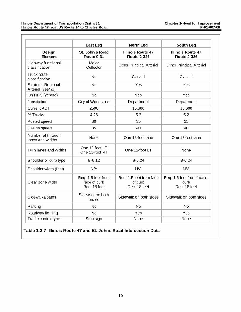
East Leg North Leg South LegDesign
ElementSt. John's Road
Route 9-31Illinois Route 47
Route 2-326Illinois Route 47
Route 2-326Highway functionalclassification
MajorCollector Other Principal Arterial Other Principal Arterial
Truck routeclassification No Class II Class II
Strategic RegionalArterial (yes/no)
No Yes Yes
On NHS (yes/no) No Yes YesJurisdiction City of Woodstock Department DepartmentCurrent ADT 2500 15,600 15,600% Trucks 4.26 5.3 5.2Posted speed 30 35 35Design speed 35 40 40
Number of throughlanes and widths None One 12-foot lane One 12-foot lane
Turn lanes and widths One 12-foot LTOne 11-foot RT One 12-foot LT None
Shoulder or curb type B-6.12 B-6.24 B-6.24
Shoulder width (feet) N/A N/A N/A
Clear zone widthReq: 1.5 feet from
face of curbRec: 18 feet
Req: 1.5 feet from faceof curb
Rec: 18 feet
Req: 1.5 feet from face ofcurb
Rec: 18 feet
Sidewalks/paths Sidewalk on bothsides Sidewalk on both sides Sidewalk on both sides
Parking No No NoRoadway lighting No Yes YesTraffic control type Stop sign None None
Table 1.2-7 Illinois Route 47 and St. Johns Road Intersection Data

Illinois Department of Transportation District 1 Chapter 1-Need for ImprovementIllinois Route 47 from US Route 14 to Charles Road P-91-007-09
11
East Leg West Leg North Leg South Leg
DesignElement
Russel CourtRoute 0-3150
SchoolEntrance
Illinois Route 47Route 2-326
Illinois Route 47Route 2-326
Highway functionalclassification
Local Road orStreet None Other Principal
ArterialOther Principal
Arterial
Truck routeclassification No No Class II Class II
Strategic RegionalArterial (yes/no)
No No Yes Yes
On NHS (yes/no) No No Yes Yes
Jurisdiction City ofWoodstock
School District200 Department Department
Current ADT 4,100 N/A 10,800 15,600% Trucks 0.0 N/A 5.0 4.5Posted speed 25 N/A 35 35Design speed 30 N/A 40 40
Number of throughlanes and widths One 20-foot lane One 20-foot
lane One 12-foot lane One 12-foot lane
Turn lanes and widths None None One 12-foot LT One 12-foot LT
Shoulder or curb type B-6.24 B-6.24 B-6.24 B-6.24
Shoulder width (feet) N/A N/A N/A N/A
Clear zone widthReq: 1.5 feet
from face of curbRec: 18 feet
Req: 1.5 feetfrom face of
curbRec: 18 feet
Req: 1.5 feet fromface of curbRec: 18 feet
Req: 1.5 feet fromface of curbRec: 18 feet
Sidewalks/paths Sidewalk on bothsides
Sidewalk onsouth side
Sidewalk on eastside
Sidewalk on eastside
Parking No No No NoRoadway lighting No Yes Yes YesTraffic control type Signal Signal Signal Signal
Table 1.2-8 Illinois Route 47 and Russel Court Intersection Data

Illinois Department of Transportation District 1 Chapter 1-Need for ImprovementIllinois Route 47 from US Route 14 to Charles Road P-91-007-09
12
East Leg North Leg South Leg
Design ElementWare Road
Route 9-3851Illinois Route 47
Route 2-326Illinois Route 47
Route 2-326
Highway functional classification Major Collector Other PrincipalArterial
Other PrincipalArterial
Truck route classification Local Truck Class II Class II
Strategic Regional Arterial(yes/no)
No Yes Yes
On NHS (yes/no) No Yes YesJurisdiction City of Woodstock Department DepartmentCurrent ADT 3,500 8,100 10,800% Trucks 15.38 8.6 9.4Posted speed 40 45 and 50 35Design speed 45 45 and 50 40
Number of through lanes andwidths None One 12-foot lane One 12-foot lane
Turn lanes and widths One 11-foot LTOne 12-foot RT One 12-foot LT None
Shoulder or curb type B-6.12 B-6.12Asphalt Shoulder B-6.12
Shoulder width (feet) None 11 (Asphalt) None
Clear zone widthReq: 1.5 feet from
face of curbRec: 18 feet
18 to 28 feetReq: 1.5 feet
from face of curbRec: 18 feet
Sidewalks/paths Sidewalk on northside None Sidewalk on east
side
Parking No No NoRoadway lighting No No YesTraffic control type Stop sign None None
Table 1.2-9 Illinois Route 47 and Ware Road Intersection Data

Illinois Department of Transportation District 1 Chapter 1-Need for ImprovementIllinois Route 47 from US Route 14 to Charles Road P-91-007-09
13
East Leg West Leg North Leg South Leg
Design ElementCharles RoadRoute 2-333
Charles RoadRoute 2-333
Illinois Route 47Route 2-326
Illinois Route 47Route 2-326
Highway functionalclassification
Other PrincipalArterial Major Collector Other Principal
ArterialOther Principal
Arterial
Truck routeclassification No No Class II Class II
Strategic RegionalArterial (yes/no)
No No Yes Yes
On NHS (yes/no) Yes Yes Yes YesJurisdiction McHenry County McHenry County Department DepartmentCurrent ADT 6,100 6,500 4,600 8,100% Trucks 6.23 2.51 11.0 11.3Posted speed 55 55 50 50Design speed 60 60 50 50
Number of throughlanes and widths One 11-foot lane One 11-foot lane One 12-foot lane One 12-foot lane
Turn lanes and widths None None None None
Shoulder or curb type HMA, aggregate HMA, aggregate HMA, aggregate HMA, aggregate
Shoulder width (feet) HMA-4Aggregate-1
HMA-1.5Aggregate-1.5
HMA-1Aggregate-9 to 15
HMA-1Aggregate-8
Clear zone width 30 feet 30 feet 18 to 28 feet 18 to 28 feetSidewalks/paths None None None NoneParking No No No NoRoadway lighting No No No NoTraffic control type Stop sign Stop sign Stop sign Stop sign
Table 1.2-10 Illinois Route 47 and Charles Road Intersection Data
1.2.3 Land Use
The existing City of Woodstock Land Use Map can be found in Exhibit 1.2.4. US 14 to Lake Avenue iszoned mainly as commercial. Businesses along this route include car dealerships, car repair centers,professional offices, and fast food chains, among others. Many businesses require large trucks thataccess the business throughout the day.
Lake Avenue to Country Club Road is zoned for commercial businesses, multiple-family residential witha manufacturing/industrial district at the northeast corner of the IL 47 and Lake Avenue intersection.

Illinois Department of Transportation District 1 Chapter 1-Need for ImprovementIllinois Route 47 from US Route 14 to Charles Road P-91-007-09
14
Businesses along this portion of the Project include grocery stores, major retail, and banks. Manybusinesses require large trucks that access the business throughout the day.
Land use along IL 47 between Country Club Road and IL 120 is zoned as a commercial district consistingof service and retail offices and shopping centers. There are single- and multiple-family homes near theIL 120 and IL 47 intersection. A manufacturing/industrial district is located on the west side of IL 47.
Land use from IL 120 to St. Johns Road is a mix of commercial shopping centers, elderly care facilities,offices, and single- and multiple-family homes.
The land use between St. Johns Road to Ware Road along IL 47 consists mainly of single-familyresidential homes on the west side and mixed commercial businesses on the east side. There is a middleschool located west of the Ware Road and IL 47 intersection. The McHenry County Government Centerand other related offices are located directly east of the intersection.
From Ware Road to Charles Road, land is primarily open space, agricultural farm land, and farm houses.There is also a commercial landscaping business, a real estate business, and a Presbyterian churchalong IL 47 within this section. There is one subdivision of single-family homes east of the IL 47 andCooney Drive intersection.
1.2.4 Environmental Resources
There are several environmental resource areas within the IL 47 study area. These include the EastBranch of Silver Creek, an unnamed tributary to Silver Creek, a deep-water aquatic habitat, Bates Park,wetlands, floodplains, and farmland.
The FAP 326 Illinois Route 47, US Route 14 to Charles Road, McHenry County EnvironmentalAssessment (EA) evaluated impacts to natural resources including wetlands, water quality, floodplains,and threatened and endangered species. The analysis also included an investigation of noise impactsand potential hazardous material within the study area. The EA can be found in Supplement 1.2-1. TheEA Errata can be found in Supplement 1.2-2. The Finding of No Significant Impacts (FONSI) was signedon October 24, 2018 and can be found in Supplement 1.2-3.
1.2.5 Public Facilities and Services
Major community facilities along the project study area are schools and government buildings that arelocated at the intersection of IL 47 and Ware Road. The schools are a part of Public School District No.200. Several school bus routes use IL 47 within the project study area. The City of Woodstock is thecounty seat of McHenry County. The government center is located on Ware Road toward the north endof the project study area. The McHenry County fairgrounds are located on Country Club Road two blockseast of IL 47. Places of worship are also located along the project study area.
Two Pace bus routes use IL 47 and include stops along IL 47. No additional future bus routes areproposed for the project study area.
IL 47 passes under the Union Pacific Railway between Lake Avenue and McConnell Road. The nearestalternative crossing is an at-grade crossing on Madison Street, approximately one mile west via Lake

Illinois Department of Transportation District 1 Chapter 1-Need for ImprovementIllinois Route 47 from US Route 14 to Charles Road P-91-007-09
15
Avenue. Because this dual-track rail line carries frequent commuter and freight traffic, the railroad trackson the bridge must remain open at all times. The nearest Metra stop to the project study area is locatedapproximately 1,800 feet west of the Project at the intersection of IL 120 and North Benton Street inWoodstock. This Metra stop is outside the Project study area.
1.2.6 Existing Drainage
From US 14 to Ware Road, existing IL 47 is primarily a closed drainage system with curb and gutterrunning along the outside of the roadway. Intermittent ditches exist behind the curb and gutter. Severaloutlets exist within this section. Residents have reported pavement flooding along IL 47 between US 14and McConnell Road. Pavement flooding was also reported at the intersection of IL 47 and Russel Court.
From Ware Road to Charles Road, existing IL 47 is an open drainage system with ditches running alongthe outside of the roadway or water sheet-flowing out of the right-of-way into open fields.
An unnamed tributary crosses underneath IL 47 via a 10-foot-wide by 8-foot-tall box culvert locatedapproximately 1,200 feet south of South Street. It is in overall good condition.
Silver Creek crosses underneath IL 47 via a 7-foot-wide by 8-foot-tall box culvert between Cherry Courtand Birch Road. This culvert is hydraulically insufficient.
An unnamed tributary to Silver Creek crosses underneath IL 47 via a 6-foot-wide by 5-foot-tall box culvertsouth of Cooney Drive. This culvert is hydraulically insufficient.
The Existing Drainage Plan can be found in the Location Drainage Study under separate cover. A SoilSurvey was also conducted for this project and can be found in Supplement 1.2-4.
1.3 OPERATIONAL AND SAFETY ANALYSES, IDENTIFIED DEFICIENCIES
1.3.1 Project History
Previous studies were initiated locally to study the future needs of IL 47 through the City of Woodstock.A study sponsored by the City of Woodstock in 1995 made several recommendations, ultimatelyincorporating two lanes in each direction throughout the project study area with a center flush medianfrom US 14 to Ware Road and a raised median from Ware Road to Charles Road. The study concludedthe section from IL 120 to Charles Road would require a three-lane cross section in the interim. However,the study noted traffic volumes would increase and would ultimately require a five-lane cross section.This study also recommended the implementation of access control strategies, various intersectionimprovements to increase roadway capacity, and replacement of the Union Pacific railroad bridge. TheDepartment’s 1995 Strategic Regional Arterial Planning Study for Illinois Route 47 recommended thesesame measures. An additional study was conducted by the City of Woodstock in 2006. A five-lane crosssection was recommended from US 14 to IL 120 and from Ware Road to Charles Road, with flush andraised medians, access control, various local improvements, and replacement of the railroad bridge. Inthis study, a three-lane cross section was recommended through the residential section of the Projectfrom IL 120 to Ware Road.

Illinois Department of Transportation District 1 Chapter 1-Need for ImprovementIllinois Route 47 from US Route 14 to Charles Road P-91-007-09
16
1.3.2 Identified Deficiencies
Increased travel demands on IL 47 are creating safety and operational deficiencies along the immediateroadway and adjacent arterials and intersections. The insufficient capacity of the roadway to managetravel demands creates congestion, limits mobility, hinders safe access to adjacent properties andbusinesses, and leads to safety issues for motorists, bicyclists, and pedestrians. Pedestrian access toadjacent land and bicycle accessibility through and across the project study area are limited.
1.3.2.1 Safety Deficiencies
Crash data was collected from Department for years 2010 through 2014. The crash analysis canbe found in Supplement 1.3-1. The total number of crashes for the study period was 651, asshown in Figure 1.3-1.
Figure 1.3-2 describes the 651 crashes by crash type. The predominant crash types for the studyperiod were rear-end (60 percent), turning (18 percent), angle (11 percent), and sideswipe of carstraveling in the same direction (3 percent). Other types of crashes included animal, head-on,sideswipe of vehicles in opposite directions, and fixed objects.
Figure 1.3-1 Total Crashes 2010 to 2014
137 144118 130 122
651
0
100
200
300
400
500
600
700
2010 2011 2012 2013 2014 Total
Cras
hes
Year

Illinois Department of Transportation District 1 Chapter 1-Need for ImprovementIllinois Route 47 from US Route 14 to Charles Road P-91-007-09
17
Rear-end, turning, and angle crashes are usually caused by several factors, such as deficiencyin the capacity of the roadway, signal timing issues because of lack of signal modernization,improper design of the roadway leading to incomplete channelization of traffic, lack of raisedmedians, and insufficient drainage of the pavement. The lack of capacity on this two-laneroadway, coupled with the numerous entrances, leads to conflicts that result in crashes.
Of the crashes, 77.7 percent occurred during the day and 79.1 percent occurred during clearweather. This indicates that lighting conditions, weather, and wet pavement do not appear tosubstantially contribute to crashes.
Of the total crashes, 202 (31.0 percent) were injury crashes that resulted in 306 injuries. Therewere no fatalities recorded during the study period; however, there were 14 incapacitatingType “A” injuries, which are the most severe injury type that is not a fatality. There were threecrashes involving a pedestrian and three crashes involving a bicyclist. The first pedestrian crashoccurred during the 11 A.M. hour at the intersection with Lake Avenue and resulted in a reportedType “C” injury. The second pedestrian crash occurred during the 8 P.M. hour at the intersectionwith Judd Street and Irving Avenue and resulted in a Type “B” injury. The third pedestrian crashoccurred during the 11 P.M. hour at the intersection with IL 120, and it resulted in a Type “B” injury.Two bicyclist crashes occurred between the intersections of Lake Avenue and McConnell Drive.Both resulted in Type “B” injuries. The first crash involving a bicyclist occurred during the 10 A.M. hour and the second crash involving a bicyclist occurred during the 3 P.M. hour. The third crash
Figure 1.3-2 2010 to 2014 Crash Types
60%18%
11%
3%7%
Rear End
Turning
Angle
Sideswipe Same
Others

Illinois Department of Transportation District 1 Chapter 1-Need for ImprovementIllinois Route 47 from US Route 14 to Charles Road P-91-007-09
18
involving a bicyclist occurred between IL 120 and St. Johns Road during the 6 P.M. hour and italso resulted in a Type “B” injury.
Figure 1.3-3 presents the number of injuries by severity for all 651 crashes. Some crashesresulted in more than one injury.
The intersection of Lake Avenue and IL 47 is one of the busiest in the project study area and itexperienced an elevated number of crashes. There were 94 crashes within the five-year studyperiod. The majority of crashes at this location were rear-end crashes. Signal timing issues or thepermitted turn on red could have been contributing factors. The angle of skew of this intersectionalso could have been a factor causing reduced visibility that led to crashes.
Although there are no 5% locations, the high incidence of crashes in the study period indicatesthat safety is an issue in the project study area. The number of rear-end crashes indicates thathigh traffic volumes, insufficient roadway capacity, and poor access management may becontributing to crashes.
1.3.2.2 Capacity Deficiencies
The Project is also needed to address capacity deficiencies in the project study area. The 2009Average Daily Traffic (ADT) varies throughout the project study area carrying 16,300 vehicles perday (vpd) at US 14, increasing to 26,200 vpd at Country Club Road, before gradually decreasingto 8,100 vpd at Charles Road. 2009 ADT was used since it was found to be consistent with abroader historical average.
Figure 1.3-3 Injury Crashes 2010 to 2014
014
97
195
306
0
50
100
150
200
250
300
350
Fatalities Type A Injuries Type B Injuries Type C Injuries Total Number ofInjuries
Num
ber o
f Inj
urie
s
Injury Type

Illinois Department of Transportation District 1 Chapter 1-Need for ImprovementIllinois Route 47 from US Route 14 to Charles Road P-91-007-09
19
Projected traffic volumes were generated by the Chicago Metropolitan Agency for Planning(CMAP) for the 2040 design year based on the No-Action scenario (i.e., no capacityimprovements; only routine maintenance). These future traffic volumes are expected in the rangeof 17,000 vpd at US 14, increasing to 27,000 vpd at Country Club Road, and decreasing to16,000 vpd south of Charles Road.
A letter from CMAP detailing projected traffic volumes, dated November 14, 2011, is shown inAppendix A. Updated traffic projections were requested from CMAP in 2015 because of the timeelapsed. After comparing the revised traffic projections to the original traffic projections in 2011,it was determined the original traffic projections developed in 2011 were sufficiently accurate tocomplete a traffic analysis and develop signal timing. The traffic projections sent by CMAP in aletter, dated October 28, 2015, can be found in Appendix A.
The level of service (LOS) of an intersection rates the operational characteristics of traffic volumesto give a measure of traffic flow. The LOS rating is a scale from A to F, with A being optimalfree-flow conditions and F indicating the intersection no longer operates properly becausedemand exceeds capacity. See Figure 1.3-4 for further explanation of LOS.
Figure 1.3-4 Level of Service

Illinois Department of Transportation District 1 Chapter 1-Need for ImprovementIllinois Route 47 from US Route 14 to Charles Road P-91-007-09
20
Sections of IL 47 between intersections were given a transitional LOS value. For example,LOS C-D indicates the section is between an intersection with LOS C and another intersectionwith LOS D. A schematic of IL 47 showing the relationship between the ADTs and the LOS of theroadway is shown in Figure 1.3-5. This figure shows increasing congestion in the 2040 designyear if no improvements are implemented.
Figure 1.3-5 2009 and Projected 2040 Future No-Build ADT and LOS

Illinois Department of Transportation District 1 Chapter 1-Need for ImprovementIllinois Route 47 from US Route 14 to Charles Road P-91-007-09
21
Overall, the existing intersection geometry and 2009 traffic volumes result in intersection LOSranges from C to D. The 2040 no-build scenario intersection LOS ranges from C to F. A summaryof the AM and PM LOS and delay for 2009 and the future no-build scenario at each intersectionis provided in Table 1.3-1.
In the PM peak hour, four of the seven intersections currently experience LOS D. By 2040, threeof the seven intersections will experience LOS D, and three signalized intersections willexperience LOS F. As a result, the future no-build PM peak hour queues and delays becomeexcessive. For example, the northbound queue at Country Club Road and Judd Street/IrvingAvenue are both over 4,000 feet. This decrease in LOS indicates excessive traffic congestion andtravel times.
1.3.2.3 Access Management
There is generally no access management along IL 47. This leads to approximately190 driveways and 31 intersections along the route. Several businesses have multiple, closelyspaced entrances serving the same parking lot. Right-in-right-out access points have only beenconstructed at three driveways throughout the entire five-mile project study area. There is onlyone side street, East Calhoun Street, where drivers are prevented from turning left onto IL 47.
There are no raised medians present in the project study area; therefore, left turns are notphysically restricted at any point. The high number of access points fosters unprotected mid-blockturning, including left turns.
AM Peak Hour PM Peak Hour
2009 2040 No-Build 2009 2040 No-Build
Intersection
Delay(seconds/vehicle) LOS
Delay(seconds/vehicle) LOS
Delay(seconds/vehicle) LOS
Delay(seconds/vehicle) LOS
US Route 14 32.7 C 45.7 D 35.8 D 45.6 D
Lake Avenue 34.2 C 100.8 F 41.8 D 135.4 F
McConnell Road 24.8 C 56.3 E 22.9 C 50.0 D
Country Club Road 32.5 C 99.2 F 37.9 D 131.7 FJudd Street/Irving Avenue 31.9 C 136.9 F 38.4 D 184.2 FIllinois Route 120/McHenry Avenue 34.6 C 53.8 D 34.0 C 41.4 D
Russel Court 22.9 C 53.7 D 20.8 C 25.4 C
Table 1.3-1 AM and PM 2009 and Future No-Build (2040) LOS and Delay by Intersection
Note: Level of Service colors match the legend provided in Figure 1.3-5.

Illinois Department of Transportation District 1 Chapter 1-Need for ImprovementIllinois Route 47 from US Route 14 to Charles Road P-91-007-09
22
Providing raised medians and using accessmanagement strategies reduces the number ofconflict points at an intersection. This is illustratedin Figure 1.3-6, which was taken from the FederalHighway Administration (FHWA) brochure SafeAccess is Good for Business, included in AppendixB. As shown in this figure, a three-leggedintersection with no access management results in11 vehicle conflict points, while a three-leggedintersection restricting left turns out of the sidestreet results in only six vehicle conflict points.
From 2010 to 2014, there were 337 mid-blockcrashes in the IL 47 project study area. Of these,75.7 percent were rear-end or turning crashes. Thelack of access management on IL 47 negativelyaffects operations and leads to a high incidence ofconflicts and, ultimately, crashes.
1.3.2.4 Pedestrian and Bicycle Accommodations
The presence of pedestrian facilities varies in theProject study area. Exhibit 1.2-3 shows the locationsof existing sidewalk and bicycle facilities in theproject study area. There are no existing bicyclepaths or bicycle accommodations within the Projectstudy area. Bicyclists must travel on IL 47 with its heavy traffic volumes, high truck volumes, andhigh turning movements. In the south section, there is 5- to 6-foot-wide sidewalk on both sides ofthe road at irregular intervals from Catalpa Lane to Judd Street/Irving Avenue. There is no sidewalkfrom Judd Street/Irving Avenue to IL 120.There are 5- to 6-foot-wide sidewalks on bothsides of the road through much of the areafrom IL 120 to Ware Road. The noncontiguousnature of pedestrian facilities in the projectstudy area means pedestrians must walkthrough parking lots, along grass parkways,and even on roadway shoulders, as shown inFigure 1.3-7. The intersections of IL 120 andRussel Court are the only locations with stripedpedestrian crossings and pedestrian signals.There are no pedestrian facilities north ofWare Road.
There are several bike and pedestriangenerators located along or near the projectstudy area. The Bicycle and Pedestrian
Figure 1.3-7 Incomplete Facilities MakePedestrian Travel Difficult
Figure 1.3-6 Access ManagementReduces Conflict Points
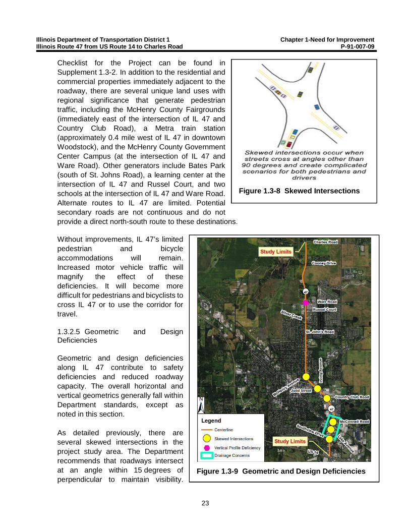
Illinois Department of Transportation District 1 Chapter 1-Need for ImprovementIllinois Route 47 from US Route 14 to Charles Road P-91-007-09
23
Checklist for the Project can be found inSupplement 1.3-2. In addition to the residential andcommercial properties immediately adjacent to theroadway, there are several unique land uses withregional significance that generate pedestriantraffic, including the McHenry County Fairgrounds(immediately east of the intersection of IL 47 andCountry Club Road), a Metra train station(approximately 0.4 mile west of IL 47 in downtownWoodstock), and the McHenry County GovernmentCenter Campus (at the intersection of IL 47 andWare Road). Other generators include Bates Park(south of St. Johns Road), a learning center at theintersection of IL 47 and Russel Court, and twoschools at the intersection of IL 47 and Ware Road.Alternate routes to IL 47 are limited. Potentialsecondary roads are not continuous and do notprovide a direct north-south route to these destinations.
Without improvements, IL 47’s limitedpedestrian and bicycleaccommodations will remain.Increased motor vehicle traffic willmagnify the effect of thesedeficiencies. It will become moredifficult for pedestrians and bicyclists tocross IL 47 or to use the corridor fortravel.
1.3.2.5 Geometric and DesignDeficiencies
Geometric and design deficienciesalong IL 47 contribute to safetydeficiencies and reduced roadwaycapacity. The overall horizontal andvertical geometrics generally fall withinDepartment standards, except asnoted in this section.
As detailed previously, there areseveral skewed intersections in theproject study area. The Departmentrecommends that roadways intersectat an angle within 15 degrees ofperpendicular to maintain visibility.
Figure 1.3-9 Geometric and Design Deficiencies
Figure 1.3-8 Skewed Intersections

Illinois Department of Transportation District 1 Chapter 1-Need for ImprovementIllinois Route 47 from US Route 14 to Charles Road P-91-007-09
24
The Department allows a maximum skew of 30 degrees where correcting the skew would beimpractical. See Figure 1.3-8 for further explanation of skew.
The six intersections that exceed a 15-degree skew are shown in yellow in Figure 1.3-9:Southview Drive, Lake Avenue, McConnell Road, Country Club Road, Judd Street/Irving Avenue,and McHenry Avenue. The skew of three of these intersections exceeds the maximum 30 degrees:Lake Avenue, Country Club Road, and Judd Street/Irving Avenue. Intersection sight distance isalso restricted at the intersection of Judd Street and Irving Avenue because of its irregularalignment and the building at the northwest corner of the intersection.
A vertical curve located just north of Ware Road is the only profile vertical deficiency within theproject study area. The recommended intersection sight distance is not achieved because of thiscurve and the 45-mile-per-hour posted speed limit.
IL 47 has had consistent reports of poor drainage between the intersections at Lake Avenue andMcConnell Road. These intersections flood during heavy rain events. Specifically, in the areaunderneath the Union Pacific Railway bridge, water ponds on the roadway and creates a hazard.
These geometric and design deficiencies contribute to mobility, safety, and operational issues,which will only worsen as traffic volumes increase.
1.4 PROJECT PURPOSE
The purpose of the Project is to address transportation safety, capacity, access management, pedestrianand bicycle needs, and geometric deficiencies.

Chapter 2-Alternatives
25

Illinois Department of Transportation District 1 Chapter 2 - AlternativesIllinois Route 47 from US Route 14 to Charles Road P-91-007-09
26
This chapter describes the design criteria and alternatives considered to meet the Purpose andNeed.
2.1 DESIGN CRITERIA AND ALTERNATIVES DEVELOPMENT PROCESS
SRA design criteria in accordance with Department Bureau of Design and Environment (BDE)Manual, Chapter 46 was used to develop IL 47 alternatives. The possibility of converting IL 47 froma rural cross section to an urban or suburban cross section from Ware Road to Charles Road wasevaluated as a part of this Project and is further discussed in Section 2.3.4.
Table 2.1-1 presents the controlling geometric design criteria items as recommended by the BDEManual. Criteria is presented for urban, suburban, and rural cross sections because of the varyingcross section alternatives from Ware Road to Charles Road.
The existing speed limit along IL 47 varies within the Project study area. IL 47 from US 14 to IL 120and from Greenwood Circle to Ware Road has an existing posted speed limit of 35 mph. IL 47 fromIL 120 to Greenwood Circle has an existing posted speed limit of 30 mph. IL 47 from Ware Road to0.5 mile north of Ware Road has an existing posted speed limit of 45 mph, and IL 47 from 0.5 milenorth of Ware Road to Charles Road has an existing posted speed limit of 55 mph. IL 47 will maintainexisting speed limits from US 14 to 0.5 mile north of Ware Road and a design speed of 5 mph greaterthan the posted speed limit will be used. For the section 0.5 mile north of Ware Road and CharlesRoad, the proposed posted and design speed will be 50 mph. Multiple proposed posted and designspeeds were evaluated as part of this Project and are discussed further in Section 2.3.4. A map ofthe existing speed limits and proposed design speeds along IL 47 is shown in Figure 2.1-1.
Design Criteria Urban SRA Suburban SRA Rural SRADesign Speed Limit 30 to 40 mph 45 mph 60 mph
Number of Lanes 2 or 3 for each traveldirection
2 or 3 for each direction oftravel
2 or 3 for eachdirection of travel
Lane Width 11-foot restricted ROW12’ desired
12 feet 12 feet
Median Width andType
18- to 22-foot raisedmedian
11- to 14-foot flush median
18- to 30-foot raisedmedian
12- to 14-foot flush median
50 feet with depressedmedian
22 feet raised median
Profile Grade 7% maximum0.3% minimum(0.5% desired)
6% maximum0.3% minimum(0.5% desired)
4% maximum0% minimum
(0.5% desired)
Edge Treatment Curb and Gutter 10-foot-wide shoulder orcurb and gutter
10-foot-wide shoulder
Table 2.1-1 IL 47 Geometric Design Criteria

Illinois Department of Transportation District 1 Chapter 2 - AlternativesIllinois Route 47 from US Route 14 to Charles Road P-91-007-09
27
Figure 2.1-1 Existing Speed Limit and Proposed Design Speed Map
Illinois Department of Transportation District 1 Chapter 2 - AlternativesIllinois Route 47 from US Route 14 to Charles Road P-91-007-09
28
The Purpose and Need for this Project described in Chapter 1 summarizes the existing IL 47 deficienciesand demonstrates the need for action. Deficiencies identified in the Purpose and Need include safety,traffic operations, access management, pedestrian accommodations, and geometrics.
Establishment of the Project Purpose and Need aided in the identification of Project alternatives.Additional input on alternatives resulted from the overall agency and public involvement process using aContext Sensitive Solutions (CSS) Project development process. The CSS Project development processgathered public input to assist in identification of deficiencies and corridor needs, alternative concepts,and specific Project elements. Public input was received from a variety of sources including the ProjectStudy Group, Corridor Advisory Group (CAG), public meetings, NEPA/404 merger meetings, one-on-onestakeholder meetings, small group business meetings, a Public Hearing, and comments received throughthe Project website and mailings. The IL 47 CAG comprises many local officials, business owners,adjacent property owners, and other interested persons.
The culmination of this effort combined with the technical evaluation of the Purpose and Need, resultedin the identification of a reasonable range of build alternatives to be considered.
The No-Action Alternative and Build Alternatives developed are presented in the EnvironmentalAssessment. The EA can be found in Supplement 1.2-1. Included for each alternative is a description ofthe alternative, its ability to meet the Purpose and Need, the estimated environmental impacts associatedwith the alternative, and an overview of the initial feedback received from the CAG on each alternative.Each alternative presents a discussion of the impact to the existing Union Pacific Railway bridge or impactto the Union Pacific Railway line, as applicable. A summary follows.
2.2 ALTERNATIVES CONSIDERED
Alternatives were considered to address the needs of the project and were evaluated for engineeringobstacles and screened against the Purpose and Need. The No-Action alternative was carried forward,as required by the National Environmental Policy Act, to be used as a benchmark for evaluating thebenefits and impacts of the Build Alternatives. However, the No-Action alternative alone did not satisfythe Purpose and Need of the Project. The full range of alternatives considered were identified usingexisting roadway characteristics, future traffic demand, land use, available right-of-way, and the CSSprocess and are shown in Figure 2.2-1. Table 2.2-1 provides a brief summary of each alternativeconsidered.

Illinois Department of Transportation District 1 Chapter 2 - AlternativesIllinois Route 47 from US Route 14 to Charles Road P-91-007-09
29
Figure 2.2-1 IL 47 Full Range of Alternatives with Environmental Resources

Illinois Department of Transportation District 1 Chapter 2 - AlternativesIllinois Route 47 from US Route 14 to Charles Road P-91-007-09
30
Alternative Alignment and Characteristics
Alternative A Widening along the existing IL 47 alignment between US 14 and Charles Roadwith two lanes in each direction and a raised center median.
Alternative B1IL 47 western bypass around Woodstock using US 14, Lamb Road,Charles Road, and new roadway. The cross section included two lanes in eachdirection and a raised center median.
Alternative B2IL 47 eastern bypass around Woodstock using Zimmerman Road,Raffel Road, and new roadway. The cross section included two lanes in eachdirection and a raised center median.
Alternative C1
One-way couplet splitting the northbound and southbound IL 47 traffic betweenSouthview Drive and St. John’s Road. Southbound traffic would stay on theexisting IL 47 alignment and northbound traffic would be along new roadway,Zimmerman Road, and Irving Avenue. Northbound IL 47 would be an urbantwo-lane cross section and southbound IL 47 would remain a three-lane crosssection. Outside the couplet, IL 47 would be expanded to two lanes in eachdirection with a raised center median.
Alternative C2
One-way couplet splitting the northbound and southbound IL 47 traffic betweenSouthview Drive and Ware Road. Southbound traffic would stay on the existingIL 47 alignment and northbound traffic would be along new roadway,Zimmerman Road, and Hickory Road. Northbound IL 47 would be an urbantwo-lane cross section and southbound IL 47 would remain a three-lane crosssection. Outside the couplet, IL 47 would be expanded to two lanes in eachdirection with a raised center median.
Alternative C3
One-way couplet splitting the northbound and southbound IL 47 traffic betweenIrving Avenue and St. John’s Road. Southbound traffic would stay on theexisting IL 47 alignment and northbound traffic would be along Irving Avenueand new roadway. Outside the couplet, IL 47 would be expanded to two lanesin each direction with a raised center median.
Alternative C4
One-way couplet splitting the northbound and southbound IL 47 traffic betweenIrving Avenue and Ware Road. Southbound traffic would stay on the existing IL47 alignment and northbound traffic would be along Irving Avenue, HickoryRoad, and a new roadway. Outside the couplet, IL 47 would be expanded totwo lanes in each direction with a raised center median.
Table 2.2-1 Illinois Route 47 Full Range of Alternatives Description

Illinois Department of Transportation District 1 Chapter 2 - AlternativesIllinois Route 47 from US Route 14 to Charles Road P-91-007-09
31
A summary of the preliminary potential impacts of each build alternative is shown in Table 2.2-2. Wetland,floodplain, and stream crossing impacts for the bypass and couplet alternatives were determined usingNational Wetland Inventory maps. No survey on site was completed for the bypass and coupletalternatives.
The existing alignment build alternative (Alternative A) met the Project Purpose and Need and wasrecommended to be carried forward for further analysis. It will increase roadway capacity, will includepedestrian and bicycle accommodations, and will provide feasible and practical repairs to geometricdeficiencies.
The bypass alternatives (Alternatives B1 and B2) did not satisfy the Purpose and Need and were notcarried forward for further analysis. The traffic congestion, related safety deficiencies, and geometricdeficiencies on existing IL 47 would continue in these alternatives. Additionally, designating a bypassroute would not address access management or pedestrian and bicycle accommodations.
Each of the one-way couplet alternatives could satisfy the Project Purpose and Need because bothexisting IL 47 and the new corridor would be improved. The traffic model showed that traffic congestionand delay would be reduced and, therefore, would improve safety. The existing IL 47 edge of pavementwould be sufficient in the adjacent one-way couplet areas, but work would be required to implementaccess management, provide pedestrian accommodations, and address the geometric issues. Indiscussions with the IL 47 CAG, there was no support for the one-way couplet alternatives. While thealternatives met the Purpose and Need, the lack of support for the one-way couplet alternatives providedadequate justification to not carry them forward for further consideration.
For the reasons mentioned above, it was recommended that Bypass Alternatives B1 and B2, andCouplet Alternatives C1, C2, C3, and C4 not be carried forward. Alternative A, the existing alignmentalternative with pedestrian accommodations, was be carried forward for further analysis.
Property Impacts Environmental Impacts
Alternative
Right-of-Way(acres)
PotentialRelocated
Residences
PotentialRelocated
Businesses
AdditionalPropertiesAffected by
RailroadWork
Wetland(acres)
Floodplain(acres)
StreamCrossings
A 18.9 11 3 5 to 14 0.2 5.8 2B1 25.5 3 0 4 0.4 0.3 1B2 68.1 6 4 6 to 14 3.1 0.0 1C1 46.9 2 3 6 to 14 4.1 7.5 3C2 38.7 3 3 6 to 14 6.0 9.0 3C3 36.5 2 1 5 to 14 1.5 9.0 2
C4 28.3 3 1 5 to 14 3.4 10.5 2
Table 2.2-2 Impacts Summary Table

Illinois Department of Transportation District 1 Chapter 2 - AlternativesIllinois Route 47 from US Route 14 to Charles Road P-91-007-09
32
2.3 FURTHER EVALUATION OF EXISTING ALIGNMENT ALTERNATIVE
As previously discussed, Alternative A, the on-alignment alternative, was the only alternative carriedforward for further evaluation. This section of the report evaluates different subalternatives ofAlternative A to determine a preferred alternative. Each subalternative consists of two lanes in eachdirection with a shared-use path on the east side and sidewalk on the west side of IL 47.
2.3.1 Median Selection–US 14 to Ware Road
A 13-foot-wide TWLTL, 18-foot-wide raised median, and 22-foot-wide raised median weresubalternatives considered for the median along IL 47.
The raised median was selected and limits the number of access points, thereby limiting the number ofconflict points and potential crash locations. Median break locations were coordinated with the City andbusinesses and are at key access locations.
2.3.2 Intersection Alternatives
Roundabout intersections were evaluated at the following six locations:
1. IL 47 and Lake Avenue2. IL 47 and McConnell Road3. IL 47 and Irving Avenue/Judd Street4. IL 47 and IL 1205. IL 47 and Ware Road6. IL 47 and Charles Road
Five of the intersections operate better as roundabouts. The intersection of IL 47 and IL 120 functionsbetter as a signal and will remain a signalized intersection.
Signal warrant analysis at St. Johns Road determined the existing minor leg, stop-controlled intersectionwill operate more efficiently as a signalized intersection.
In general, roundabouts typically reduce the rate of angle crashes and injury crashes. The lower speedsat which a roundabout operates will likely result in less severe crashes. One study showed thatconversion to roundabout control has reduced an average of 39 percent of the total crashes and76 percent of the injury crashes at 24 intersections studied (From Insurance Institute for Highway SafetyStatus Report Vol. 35, No 5).
Roundabouts also increase the safety of skewed intersections. The intersections of Lake Avenue,McConnell Road, and Judd Street/Irving Avenue all exceed the maximum recommended intersectionskew of 15 degrees. Roundabouts help eliminate the skew of the intersection, lowering the sight anglerequired by drivers. Roundabouts also only require drivers to look in one direction when entering theintersection.
Finally, roundabouts reduce the number of conflict points when compared to a traditional signalizedintersection. A traditional signalized intersection has 32 conflict points, while a roundabout intersectiononly has eight conflict points.

Illinois Department of Transportation District 1 Chapter 2 - AlternativesIllinois Route 47 from US Route 14 to Charles Road P-91-007-09
33
2.3.3 Detailed Alignments–US 14 to Ware Road
IL 47 at IL 120:The horizontal curve radius was increased improving the sight distance and eliminating the needfor superelevation.
Greenwood Avenue:The west leg of Greenwood Avenue was realigned to the north to align with Greenwood Circle.
2.3.4 Alternatives from Ware Road to Charles Road
2.3.4.1 Speed Limit/Design Speed Alternatives from Ware Road to Charles Road
Three alternatives were considered for the posted and design speed limits between Ware Roadand Charles Road. These alternatives are:
Alternative 1–Match Existing 45 and 55mph Posted and use 50 and 60 mph Design Speeds
Alternative 2–45 and 50mph Posted Speed, 50mph Design Speed
Alternative 3–45mph Posted Speed, 50mph Design Speed
Speed Limit/Design Speed to be Carried Forward
Based on the analyses, Speed Limit Alternative 2, consisting of a 45 mph proposed postedspeed limit (50 mph design speed) from Ware Road to 0.5 mile north of Ware Road, and a50 mph proposed posted speed (50 mph design speed) from 0.5 mile north of Ware Road toCharles Road was carried forward as the preferred alternative.
2.3.4.2 Typical Section Alternatives from Ware Road to Charles Road
Three different typical section alternatives were considered for the section along IL 47 fromWare Road to Charles Road and can be found in Exhibit 2.3-1.
Alternative 1–Smallest Footprint, Closed Drainage System includes mountable curb off theoutside shoulder and no 5’ sidewalk shelf on the west side of IL 47 and a shallow ditch withstorm sewer on the east side of IL 47.
Alternative 2–Smallest Footprint, Open Drainage System includes a 1:4 foreslope off theoutside shoulder and no 5’ sidewalk shelf on the west side of IL 47.
Alternative 3–Largest Footprint, Open Drainage System includes a 1:6 foreslope off theoutside shoulder and a 5’ sidewalk shelf on the west side of IL 47.
Typical Section to be Carried Forward–Based on impacts associated with each alternative, thedesign criteria for the section, and the future anticipated use of the section, Alternative 2 wascarried forward as the preferred alternative.

34
CHAPTER 3DESCRIPTION OF PROPOSED IMPROVEMENTS

Illinois Department of Transportation District 1 Chapter 3-Description of Proposed ImprovementsIllinois Route 47 from US Route 14 to Charles Road P-91-007-09
35
3.1 INTRODUCTION
As discussed in Chapter 2, the on-alignment alternative was selected as the preferred alternativebecause the bypass and couplet alternatives failed to meet the Project Purpose and Need. After theon-alignment alternative was selected as the preferred alternative, further alternative analysis wascompleted for select sections of the project study area. This section discusses more detailed designaspects of the preferred alternative selected.
3.2 DESIGN CRITERIA UTILIZED
IL 47 is a reconstruction project and uses the SRA design criteria in accordance with the DepartmentBDE Manual, Chapter 46. IL 47 is classified as an urban SRA from US 14 to Ware Road and a rural SRAfrom Ware Road to Charles Road. The Design Criteria Checklist can be found in Supplement 3.2-1.
3.3 GEOMETRIC IMPROVEMENTS
On-alignment improvements were selected as the Project preferred alternative. Throughout the Project,the proposed roadway consists of two 12-foot lanes in each direction separated by a median. Lane widthsnarrow to 11-foot lanes under the Union Pacific Railroad bridge and between Judd/Irving Avenue andChristian Way. Widening to two lanes in each direction is necessary throughout the Project study area toaccommodate current traffic needs and projected 2040 traffic needs. Proposed typical sections can befound in Exhibit 3.3-1. Proposed Plan and Profile Drawings can be found in Exhibit 3.3-2.
From US 14 to Ware Road, an 18-foot raised median is proposed to separate the travel directions. Araised median was selected as a part of the preferred alternative because of the increased safety itprovides when compared to a TWLTL. Median break openings were selected based on traffic needs,public input, and design criteria for median break spacing. B-6.24 curb and gutter will run along theperimeter of the median and at the edge of pavement.
From Ware Road to Charles Road, 4-foot-wide paved inside shoulders are proposed along with a14-foot-wide mountable median. The paved inside shoulders are not shown in the preferred alternativedrawings but will be included in the Phase II design. M-4.24 curb and gutter will run along the perimeterof the median. A 10-foot-wide paved asphalt shoulder is proposed at the outside edge of pavement.Drainage ditches are proposed outside the asphalt shoulder. The mountable median, asphalt shoulders,and drainage ditches were selected as a part of the preferred alternative because of the increased designspeed in this section and the rural design criteria.
A 5-foot sidewalk will be constructed west of the roadway from US 14 to Ware Road, and a 10-footshared-use path will be constructed east of the roadway throughout the length of the Project.
The Project Purpose and Need identified several intersections currently operating at a poor LOS becauseof the number of through- and turning-lanes. Also, several intersections are currently skewed, resultingin decreased visibility. Major intersections are proposed to be widened and reconstructed as a part of theProject to accommodate traffic needs. Five roundabouts are proposed as part of the Project becausethey address visibility issues, increase traffic capacity, and increase safety. Signalized and roundaboutintersections within the project study area are discussed further in Section 3.8.

Illinois Department of Transportation District 1 Chapter 3-Description of Proposed ImprovementsIllinois Route 47 from US Route 14 to Charles Road P-91-007-09
36
According to BDE Manual Chapter 46, it is recommended urban curbed facilities attempt to meethorizontal clear zone requirements of uncurbed facilities and curbed facilities in rural areas. For designspeeds of 40 mph or less and ADT values of 6,000 vpd or more, similar to IL 47 from US 14 to WareRoad, this clear zone requirement is 16 to 18 feet. This clear zone cannot be met because of the narrowurban corridor. However, the BDE Manual also recognizes urban curbed corridors are often unable tomeet the clear zone requirements and states a minimum horizontal, obstruction-free clearance of 1.5 feetshould be provided as measured from the face of curb. There will not be any obstructions within the1.5-foot horizontal clearance.
According to BDE Manual Chapter 38, a clear zone of 18 to 28 feet is required in rural cross areas witha design speed of 45 to 50 mph and ADT values over 6000 vehicles per day, similar to IL 47 from WareRoad to Charles Road. This clear zone will be provided for a majority of the section. Where the clearzone cannot be provided, guardrail will be designed to protect vehicles from obstructions as part of thecontract plan preparation process.
3.4 PAVEMENT DRAINAGE
From US 14 to Ware Road, curb and gutter is proposed along the raised median and edge of pavement.The pavement runoff will be captured via inlets located within the curb and gutter draining to a closeddrainage system. A majority of the right-of-way tributary to the road will drain over the curb and into thegutter. In some areas where practical, ditches will be constructed between the sidewalk or path and curbto minimize flow into the roadway. The culvert carrying the and un-named tributary south of South Streetwill be repaired and extended. The culvert carrying Silver Creek underneath IL 47 between Cherry Courtand Birch Road will be reconstructed.
From Ware Road to Charles Road, curb and gutter with inlets and storm sewer is proposed along themedian to capture water within the median. Drainage ditches are proposed on the outside of the roadwayto convey water to the appropriate outlets. The culvert carrying an unknown tributary to Silver Creekunderneath IL 47 directly south of Cooney Drive will be reconstructed.
Best management practices will be incorporated into the proposed drainage plan. Several outlets areproposed throughout the project study area. Eight detention basins are proposed from US 14 toCharles Road. The proposed drainage plan can be found in the Location Drainage Study, under separatecover.
3.5 DESIGN EXCEPTIONS
There are 63 design exceptions for the Project. A Design Exception Summary Table can be found inExhibit 3.5-1. These exceptions were presented and approved at the February 5, 2019 Bureau of Designand Environment/Federal Highway Administration Coordination Meeting. Design Exception Forms canbe found in Supplement 3.5-1.
3.6 RIGHT-OF-WAY
Land Use Summary: The transportation improvements will require that a total of ten buildings onnine properties be displaced. Eight of these buildings will need to be taken completely because they willno longer be functional after the transportation improvements. These properties include three businesses,two business complexes occupied by four total businesses, and three residential homes. The remaining

Illinois Department of Transportation District 1 Chapter 3-Description of Proposed ImprovementsIllinois Route 47 from US Route 14 to Charles Road P-91-007-09
37
two properties requiring building displacements will still be functional and will allow the buildings to berebuilt at a different location on the property. Both of these buildings are commercial businesses. Theproposed action will also require one commercial building modification.
The Uniform Relocation Assistance and Real Property Acquisition Policies Act of 1970, as amended, andthe Department Land Acquisition Procedures Manual will be followed. All housing resources are availableto all relocates without discrimination. Housing of last resort will be provided if necessary.
According to the Uniform Act of 1970 (49 CFR 24), Decent, Safe, and Sanitary (DSS) housing must beavailable prior to requiring those affected by the Project to leave their existing dwelling. DSS residentialproperties of various sizes within the project study area were identified by the Department in accordancewith relocation planning procedures under 49 CFR 24.205.
Preliminary cross sections were developed for the preferred alternative to determine right-of-way needsand Project limits. The preferred alternative cross sections can be found in Supplement 3.6-1. Theright-of-way impacts associated with the preferred alternative are summarized below.
Temporary Easements: 16.255 total acresPermanent Easement: 0.173 total acresPermanent Right-of-Way: 33.088 total acresTotal Parcels: 294
Land Use Summary: Existing right-of-way was determined using available plats, and it was estimatedbased on existing fence and sidewalk locations. Existing right-of-way should be verified during thecontract plan preparation process. Frontage right-of-way is required from a majority of the propertiesalong IL 47 within the project study area because of roadway widening and pedestrian accommodations.In total, right-of-way or easements are required from 151 commercial properties, 100 single-familyresidential properties, 16 agricultural properties, 13 governmental/institutional properties, 11 multi-familyresidential properties, and 3 industrial properties.
3.7 STRUCTURES
The Union Pacific Railway bridge crosses over IL 47 between Lake Avenue and McConnell Road(Structure Number [SN] 056-0044). The Union Pacific Railway bridge will not be reconstructed as part ofthe Project. Minor rehabilitation to the bridge is necessary. A pedestrian tunnel is proposed east of theroadway bridge to accommodate pedestrians and bicyclists. The Union Pacific Railway bridge conditionreport can be found in Supplement 3.7-1. Agency Coordination Documentation can be found inAppendix A.
A 10-foot-wide by 8-foot-high box culvert carries IL 47 over a drainage ditch approximately 1,200 feetsouth of South Street (SN 056-0241). Because of the overall good condition of the existing structure, it isrecommended the structure be repaired and extended as part of the Project. The culvert condition reportcan be found in Supplement 3.7-1.
A dual corrugated metal pipe culvert carries a private drive over the drainage ditch located approximately1,290 feet south of South Street and 100 feet east of IL 47. This structure shall remain in place with noproposed improvements. This culvert does not have a structure number. The culvert condition report canbe found in Supplement 3.7-1.

Illinois Department of Transportation District 1 Chapter 3-Description of Proposed ImprovementsIllinois Route 47 from US Route 14 to Charles Road P-91-007-09
38
An existing 7-foot-wide by 8-foot-high box culvert carries IL 47 over Silver Creek, approximately 200 feetsouth of Birch Road. This structure is proposed to be replaced as part of the Project. The proposed culvertwill be a 16-foot-wide by 9-foot-high box culvert. The culvert condition report can be found in Supplement3.7-1. The hydraulic report for this structure requires structure replacement and can be found inSupplement 3.7-2.
An existing 6-foot-wide by 5-foot-high box culvert carries IL 47 over an unnamed tributary to Silver Creekapproximately 70 feet south of Cooney Drive. This structure is proposed to be replaced as a part of theProject. The proposed culvert will be a 12-foot-wide by 7-foot-high box culvert. A 6-foot-wide by7-foot-high overflow box culvert is also proposed directly south of the main structure at this location, witha weir wall at the upstream end of the overflow culvert. The culvert condition report can be found inSupplement 3.7-1. The hydraulic report for this structure requires replacement and can be found inSupplement 3.7-3.
3.8 TRAFFIC SIGNAL MODERNIZATION/INSTALLATION AND ROUNDABOUTS
Traffic signals are proposed to be modernized or replaced at the intersections of IL 47 and US 14,Country Club Road, IL 120, and Russel Court. Warrants are met for these intersections because theexisting intersection is signalized. New traffic signals are proposed at the intersection of IL 47 andSt. John’s Road. The new signalized intersection at St. John’s Road is warranted based on crash historyaccording to an analysis completed in 2007. Signalized intersections are not proposed to beinterconnected within the project study area because there are no signalized intersections withinone-half-mile of each other. Multilane roundabouts will be constructed at the intersections withLake Avenue, McConnell Road, Judd Street/Irving Avenue, Ware Road, and Charles Road. SeeFigure 3.8-1 through Figure 3.8-4. No other intersections within the project study area meet signal warrantcriteria. Therefore, all other intersections will remain as minor stop control. The Intersection DesignStudies can be found in Exhibit 3.8-1.

Illinois Department of Transportation District 1 Chapter 3-Description of Proposed ImprovementsIllinois Route 47 from US Route 14 to Charles Road P-91-007-09
39
Figure 3.8-1 Lake Avenue and McConnell Road Roundabouts

Illinois Department of Transportation District 1 Chapter 3-Description of Proposed ImprovementsIllinois Route 47 from US Route 14 to Charles Road P-91-007-09
40
Figure 3.8-2 Judd Street/Irving Avenue Roundabout

Illinois Department of Transportation District 1 Chapter 3-Description of Proposed ImprovementsIllinois Route 47 from US Route 14 to Charles Road P-91-007-09
41
Figure 3.8-3 Ware Road Roundabout

Illinois Department of Transportation District 1 Chapter 3-Description of Proposed ImprovementsIllinois Route 47 from US Route 14 to Charles Road P-91-007-09
42
3.9 LIGHTING
IL 47 currently has beacon lighting at intersections throughout the project study area.
Roadway lighting can be provided throughout the project study area if the City of Woodstock (City) agreesto participate in cost sharing for the lighting. For roadway lighting, the City is responsible for 100 percentof the installation cost and maintenance. Department has provided the City with anticipated local costsassociated with the Project via a Letter of Intent (LOI). The LOI is included in the Agency CoordinationDocumentation can be found in Appendix A. It is up to the City to state its intent to accept or decline theseelements of the Project and the associated costs. Corridor lighting would have an average spacing of140 feet, with lights on both sides of the street. Roadway lighting will be required approaching and at theroundabout intersections. The proposed roundabouts are subject to local cost participation andmaintenance. Lighting will be located behind the sidewalk or shared-use path. The sidewalk orshared-use path will shift slightly closer to the roadway at light pole locations to accommodate therequired light pole location.
Figure 3.8-4 Charles Road Roundabout

Illinois Department of Transportation District 1 Chapter 3-Description of Proposed ImprovementsIllinois Route 47 from US Route 14 to Charles Road P-91-007-09
43
3.10 PARKING
No on-street parking currently exists within the project study area and no on-street parking is proposedas a part of the Project.
Widening IL 47 reduces the number of existing parking spaces for businesses. Parking will be replacedor relocated to the extent possible. A list of businesses and the quantity of lost or relocated parkingcaused by the Project improvement is provided in Table 3.10-1. In total, 41 properties have a change inthe number of parking spaces. There are 221 parking spaces being removed.

Illinois Department of Transportation District 1 Chapter 3-Description of Proposed ImprovementsIllinois Route 47 from US Route 14 to Charles Road P-91-007-09
44
Property Property Address Number of ParkingSpaces Lost
US Route 14 to Country Club RoadRosati's Pizza 1652 South Eastwood Drive 3Vacant 1648 South Eastwood Drive 10Bull Valley Ford Mercury 1460 South Eastwood Drive 32Woodstock Furniture 1280 South Eastwood Drive 4Yamaha 1000 South Eastwood Drive 2Vaughans Family Restaurant 790 South Eastwood Drive 10Best Western Woodstock Inn 990 Lake Ave 19Napoli's Pizza Place 930 Lake Avenue 8Bob's Woodstock Motel 930 Lake Avenue 2Colonial Antique Mall Restoration Center 890 Lake Avenue 12Murphy’s Flooring 2104 South Eastwood Drive 3Woodstock Farm and Lawn Center 2020 South Eastwood Drive 1Marco's Auto 1175 South Eastwood Drive 8Turn Key Digital 995 South Eastwood Drive 1Woodstock Auto Body 1295 South Eastwood Drive 10Citgo 501 South Eastwood Drive 4Goodyear 681 South Eastwood Drive 2Cost Cutters 677 South Eastwood Drive 2Dental Center 669 South Eastwood Drive 2Quiznos Subs 667 South Eastwood Drive 2Pro Nails Spa 665 South Eastwood Drive 2Family Dentistry of Woodstock 651 South Eastwood Drive 2State Farm 717 South Eastwood Drive 5Universal Cash Express 713 South Eastwood Drive 5Nails 2000 709 South Eastwood Drive 5Domino’s Pizza 701 South Eastwood Drive 5Gas Cap Fuels 401 South Eastwood Drive 4Country Club Road to Ware RoadGreat Lakes Credit Union 180 South Eastwood Drive 6Matrix IV 610 East Judd Street 4Bott's Parts 315 North Eastwood Drive 3Beef Village 1125 North Seminary Avenue 2RD Signs 1143 North Seminary Avenue 1RDS Cycling 1143 North Seminary Avenue 1Calligraphy Studio 1143 North Seminary Avenue 1Schneider Leucht Merwin & Cooney Funeral Home 1211 North Seminary Avenue 16Artistica Wave Beauty SalonUniversal Travel
1317 North Seminary Avenue 1
Wisted's Super Market 330 North Eastwood Drive 2McHenry County Housing Authority 1018 North Seminary Avenue 3Free Methodist Church 934 North Seminary Avenue 3Farmers InsuranceBoe Hanlin & Emery Group LLCMcHenry County USBS Assoc.
1216 North Seminary Avenue 1
Michel J Mcnerney Attorney at Law 1320 North Seminary Avenue 2Crossroads Care Center 309 McHenry Avenue 11Mapletree Apartments 1917 Sheila Street 12St. John’s Lutheran Church 401 St. Johns Road 14Ware Road to Charles RoadNone - -
Total Stalls Impacted - 221
Table 3.10-1 Impacted Parking Spaces

Illinois Department of Transportation District 1 Chapter 3-Description of Proposed ImprovementsIllinois Route 47 from US Route 14 to Charles Road P-91-007-09
45
3.11 BICYCLISTS AND PEDESTRIANS
In accordance with the Complete Streets Policy, pedestrian and bicyclist accommodations are required,because the through-lanes are proposed to be moved.
There are existing sidewalks along IL 47 in intermittent locations. There are only striped crosswalkfacilities with pedestrian pushbuttons located at the intersections of IL 47 and IL 120, and at IL 47 andRussel Court.
The proposed improvements will include construction of a 5-foot sidewalk on the west side of IL 47 fromUS 14 to Ware Road. The sidewalk will typically be offset three feet from the back of curb. When thesidewalk is required to be located at the back of the curb because of right-of-way constraints orobstructions, the sidewalk widens to seven feet. Existing sidewalk will be replaced on sideroads withinthe construction limits.
A 10-foot shared-use path is proposed on the east side of IL 47 throughout the project study area. Thepath will be offset five feet from the face of the curb south of Ware Road. North of Ware Road, the pathwill generally be located outside the roadside ditch, increasing the distance between the roadway andshared-use path. At two locations along IL 47, the path width is reduced to eight feet to minimizeright-of-way impacts.
Pedestrian crosswalks will be provided at all signalized and roundabout intersections. The splitter islandsof roundabouts will provide a place of refuge for pedestrians crossing the intersections. All pedestrianimprovements will meet Americans with Disabilities Act requirements.
As previously mentioned, a pedestrian tunnel under the railroad is proposed east of the Union PacificRailway bridge between Lake Avenue and McConnell Drive.
3.12 MASS TRANSPORTATION
Section 1.2.5 discussed the two existing Pace Bus routes that use IL 47 within the project study area, aswell as the Union Pacific Railway that crosses IL 47 between Lake Avenue and McConnell Road.
Concrete pads, 25 feet long, are proposed between the proposed curb and gutter and proposed sidewalkor shared-use path at six locations along IL 47 to accommodate pedestrians at Pace bus stops. A9-foot-wide by 13.5-foot-long concrete pad is also proposed behind the proposed shared-use pathapproximately 200 feet north of Greenwood Circle to accommodate a future Pace bus shelter and replacethe existing bus shelter that is in conflict with the preferred alternative near this location.
The Department has coordinated with Pace Bus and the Union Pacific Railway throughout the Project tobest accommodate their needs while still fulfilling the Purpose and Need of the Project. Bus turnoutlocations are not included in the design because of restricted right-of-way. Agency CoordinationDocumentation can be found in Appendix A.

Illinois Department of Transportation District 1 Chapter 3-Description of Proposed ImprovementsIllinois Route 47 from US Route 14 to Charles Road P-91-007-09
46
3.13 UTILITY CONFLICTS
There are several public and private utility conflicts throughout the Project. Public utility conflicts includeCity of Woodstock water main, storm sewer, sanitary sewer, and fiber optic lines. Private utilities existabove and below ground within the project study area. Several power poles will require relocation.Intermittent gas lines, electric lines, and telephone lines will also require relocation. Utility companies willbe required to determine the location of any utilities required to be relocated by the Project. Exactlocations of utility conflicts will be determined in the design phase of the Project.
3.14 ENCROACHMENTS
Right-of-way infringements exist intermittently along IL 47. These infringements are primarily used forcommercial parking lots. The proposed improvements will require the purchase of additional right-of-wayand the removal of the current right-of-way infringements. No letters have been sent to property ownersregarding infringements.
3.15 MAIL DROP-OFF
Mail is delivered to individual mailboxes within the project study area via United States Postal Servicemail carriers. From US 14 to Beech Avenue, a majority of the mailboxes are located on private propertyoffset from the roadway. From Beech Avenue to Charles Road, a majority of the residential mailboxesare located adjacent to the roadway, allowing for mail trucks to stop along IL 47 and deliver mail. Amajority of the mailboxes located adjacent to the roadway between Beech Avenue and Charles Road willrequire relocation because of roadway widening. No mailbox turnouts currently exist or are proposedwithin the project study area.
3.16 LANDSCAPE/ROADSIDE DEVELOPMENT
All areas disturbed by construction will be restored to turf cover in accordance with the Guideline for Useof Landscape Items as appropriate for the project study area. All trees and other plants removed forconstruction will be replaced on a one-to-one nursery stock basis at a minimum wherever feasible andappropriate under Department guidelines. Forested areas or dense strands of trees and shrubs may bereplaced with seedling trees on a three-to-one basis where appropriate. Wildflower plantings will beconsidered for inclusion where applicable to the Project.
A copy of the tree survey is included in Supplement 3.16-1. Recommendations to save or remove treesare primarily based on the size and quality of the trees, as well as proposed geometrics. Final gradingand new utility locations may not be known at the time of the tree impact analysis; therefore, removalsmay increase in the design phase. However, all efforts shall be made to keep removals to a minimum inaccordance with Departmental Policy D&E-18, “A Policy on Removal and Replacement of Trees”.
Protection and care will be provided for all existing trees and shrubs to remain within the project studyarea, as provided in Section 201 of the Department’s Standard Specifications for Road and BridgeConstruction, adopted April 1, 2016. Existing trees and shrubs that are to remain will be delineated onthe plans, as will those that are to be removed.

Illinois Department of Transportation District 1 Chapter 3-Description of Proposed ImprovementsIllinois Route 47 from US Route 14 to Charles Road P-91-007-09
47
3.17 LIFT STATIONS
A lift station exists along the east side of IL 47 approximately 980 feet north of McConnell Road. The liftstation is privately owned by the business complex located on the east side of IL 47 at this location. Thelift station currently conflicts with the proposed bike path.
3.18 RETAINING WALLS
A total of 11 retaining walls are proposed as part of the Project. Retaining walls are proposed to minimizeright-of-way and environmental impacts.
3.19 OTHER
The following items were investigated and have been determined to be Not Applicable to this Project.
Dry land bridgesAt-grade railroad crossingSurveillance
3.20 ENVIRONMENTAL RESOURCES
The FAP 326 Illinois Route 47 US Route 14 to Charles Road, McHenry County EnvironmentalAssessment (EA) evaluated impacts to natural resources including wetlands, water quality, floodplains,and threatened and endangered species and provides detailed information on environmental resourcesand potential environmental and socioeconomic impacts that would result from implementation of theProject. The EA can be found in Supplement 1.2-1. The EA Errata can be found in Supplement 1.2-2.The Finding of No Significant Impacts (FONSI) was signed on October 24, 2018 and can be found inSupplement 1.2-3. The following table provide a synopsis of this information.
Resources Impact DetailsLand Use
Residential Displacements 3 displacementsBusiness Displacements 7 displacements 2 of the 7 business displacements will allow the business to be
rebuilt at a different location on the property. This will avoid acomplete take of those 2 properties. The proposed actions willalso require one commercial building modification.
Proposed Right-of-way 33.088 acres
Temporary Easement 16.428 acresAgricultural Land Conversion 17.900 acres No further coordination will be necessary with NRCS because
the Project impacts less than 10 acres of farmland per linearmile.
Wetlands and Waters of the U.S.Jurisdictional Impacts - Wetlands 0.310 acres Wetland impacts are anticipated to be mitigated at a 3:1 or
1.5:1 ratio through the use of a wetland bank.
Jurisdictional Impacts - WOUS 0.244 acres This includes two streams, a deepwater aquatic habitat, and aditch.

Illinois Department of Transportation District 1 Chapter 3-Description of Proposed ImprovementsIllinois Route 47 from US Route 14 to Charles Road P-91-007-09
48
Resources Impact DetailsBiological ResourcesFederally Threatened andEndangered Species
State Threatened and EndangeredSpecies
Floodplain 1.34 acres This includes permanent right-of-way and temporaryeasement at the crossing of the East Branch of Silver Creekacross IL 47 and an unnamed tributary to Silver Creek alongIL 47 south of Cooney Drive.
Cultural Resources No impact
4(f) Lands No impact No individual 4(f) coordination was necessary as part of thisproject. Four-week temporary occupancy was granted foraccess to Bates Park during construction.
6(f) Lands No impact No individual 6(f) coordination was necessary as part of thisproject.
Special Waste TBD 214 RECs were identified by the PESA Report. An update tothe PESA, and a PSI, if necessary, will be performed inPhase II.
Air Quality No impact
Noise No impact Noise barriers did not meet IDOT feasibility andreasonableness criteria. The Noise Report can be found inSupplement 3.20-1.
Table 3.20-1 Environmental Resource Impacts
3.21 EROSION AND SEDIMENT CONTROL
The need for erosion and sediment control measures (and any additional right-of-way necessary toaccommodate their implementation) has been evaluated for the Project.
I. Project Description
a) Proposed Construction Activity
The proposed Project consists of reconstructing and widening IL 47 from US 14 to CharlesRoad in Woodstock, Illinois.
b) Soil Disturbance
> 1.0 acre NPDES SWPPP documentation necessary

Illinois Department of Transportation District 1 Chapter 3-Description of Proposed ImprovementsIllinois Route 47 from US Route 14 to Charles Road P-91-007-09
49
c) Sensitive Environmental Resources--The presence of sensitive environmental resourcesrequiring special consideration for protection from sedimentation, or other resources whichrequire special commitments for protection will require attention during the preparation of theerosion control plan whether or not a permit is required.
yes See Commitments section
II. Information for the Erosion Control Plan
The Project will result in the disturbance of 1.0 acre or more of total land area and is subject to thestatewide general National Pollutant Discharge Elimination System (NPDES) Storm Water Permit forConstruction Site Activities. The District is responsible for preparing and updating as necessarythroughout subsequent stages of Project implementation, a Storm Water Pollution Prevention Plan(SWPPP). The portions of the Plan describing the construction activity, describing the erosion andsediment control measures intended for use and the associated maintenance practices, and describingany requirements applicable under approved State or local erosion and sediment control plans shall beprepared prior to Project implementation.
Temporary measures in accordance with applicable Department standards will be used to control erosionand sedimentation while the Project is under construction, prior to establishment of permanent measures.Permanent measures as necessary will be part of the completed Project and will be used to preventerosion and sedimentation after completion of construction. The designer shall include appropriate payitems and details in the plans and specifications to implement the selected erosion and sediment controlmeasures. The Project may also involve sensitive environmental resources to be protected during allstages of Project implementation (see Section III).
The following section includes information that will be required in the preparation of the suggested erosioncontrol plan.
1. Additional information for the preparation of the erosion control plan
a) Area of Disturbance: 103 acres
b) Environmental Resources or Critical Areas
Water resource crossings will be critical areas for the Project. Special attention will benecessary when constructing the Silver Creek crossing box culvert located south ofBirch Road, and for the Unnamed Tributary to Silver Creek crossing box located south ofCooney Drive.

Illinois Department of Transportation District 1 Chapter 3-Description of Proposed ImprovementsIllinois Route 47 from US Route 14 to Charles Road P-91-007-09
50
c) Sequence of Activity and Anticipated Erosion Control Items
Sequence
- Install sediment and erosion control systems- Install tree protection- Complete tree removal- Install storm sewer and structures- Complete roadway reconstruction with sidewalks and shared-use path- Install center medians- Place topsoil, seeding, and permanent erosion control items- Remove temporary erosion control items
Items- Perimeter erosion barrier- Temporary and permanent erosion control blanket- Inlet and pipe protection/inlet filters- Temporary ditch checks- Sediment traps- Temporary erosion control seeding
3.22 TRAFFIC MANAGEMENT PLAN
IL 47 is considered a significant route in the Work Zone Safety and Mobility Significant Route LocationMap. The Project Traffic Management Plan (TMP) can found in in Supplement 3.22-1.
The IL 47 staging conditions reflect the existing conditions with minimal deviation, providing one 11-footthrough lane in each direction and a 10-foot bidirectional left turn lane. This configuration will not increasedelays significantly over the existing traffic conditions.
IL 120 is also considered a Significant Route in the area of IL 47. The IL 120 staging conditions reflectthe existing conditions with minimal deviation and will not increase delays significantly over the existingtraffic conditions.
The IL 47 corridor maintenance of traffic (MOT) plan is divided into two distinct sections, US 14 toWare Road and Ware Road to Charles Road. These sections were determined based on their uniqueroadway characteristics and land use. Following is a description of the proposed staging. MOT typicalsections are included in Exhibit 3.22-1.
3.22.1 IL 47–US 14 to Ware Road
US 14 to Ware Road will be constructed in three primary stages.
Pre-Stage 1 will consist of removing the existing curb and gutter along the west side of IL 47 and installingtemporary pavement approximately 14 feet wide. Temporary striping, signals, and drainage will also beperformed during the pre-stage.

Illinois Department of Transportation District 1 Chapter 3-Description of Proposed ImprovementsIllinois Route 47 from US Route 14 to Charles Road P-91-007-09
51
Stage 1 from US 14 to Ware Road consists of maintaining one lane in each direction separated by atwo-way left-turn lane (TWLTL). Southbound traffic will be shifted onto the temporary pavementconstructed during Pre-Stage 1. The existing southbound lane will be used for a TWLTL. Northboundtraffic will use the existing TWLTL. Stage 1 operations will include construction of the two permanentnorthbound travel lanes, curb and gutter running along the outside edge of northbound pavement, ashared-use path located east of the roadway, earthwork, the proposed drainage system, temporarydrainage pipes, roadway lighting, and signal posts. Stage 1a, prior to Stage 2, from US 14 to Ware willbe used to construct temporary widening along the inside edge of the newly constructed northboundlanes. Constructing the temporary widening along the northbound lanes in this stage reduces the amountof temporary widening needed along the west side of the IL 47 southbound lanes in Pre-Stage 1. Stage 1aconsists of maintaining one lane in each direction on their respective sides of the roadway with left turnlanes. The construction zone would be located in the roadway median. Southbound traffic will remain inthe same location as Stage 1. Northbound traffic will use the outside permanent northbound laneconstructed in Stage 1.
Stage 2 from US 14 to Ware Road consists of maintaining one lane in each direction separated by aTWLTL. Northbound traffic will use the outside permanent northbound lane constructed in Stage 1. Theinside permanent northbound lane will be used for a TWLTL. Southbound traffic will use a combinationof the inside permanent northbound travel lane and temporary pavement. Temporary wedges will benecessary to connect the inside permanent northbound travel lane to the existing pavement wherevertical grades are different. Stage 2 operations will include construction of the two permanentsouthbound travel lanes, curb and gutter running along the southbound outside edge of pavement, asidewalk located west of the roadway, earthwork, the proposed drainage system, temporary drainagepipes, roadway lighting, and signal posts.
Stage 3 from US 14 to Ware Road consists of maintaining one lane in each direction and will includeleft-turn lanes for each travel direction. Northbound traffic will use the outside permanent northbound laneconstructed in Stage 1. The inside permanent northbound lane will be used as a left-turn lane fornorthbound traffic. Southbound traffic will use the outside permanent southbound lane constructed inStage 2. The inside permanent southbound lane will be used as a left-turn lane for southbound traffic.Stage 3 operations will include construction of the proposed barrier median and inside curb and gutter,earthwork, the proposed drainage system, and signal posts.
3.22.2 IL 47–Ware Road to Charles Road
Ware Road to Charles Road will be constructed in two primary stages.
Pre-Stage 1 will consist of installing temporary pavement approximately six feet wide. Temporary stripingwill also be performed during the pre-stage. It is anticipated that the temporary widening would beconstructed under a moving lane closure with flaggers.
Stage 1 from Ware Road to Charles Road consists of maintaining one lane in each direction. Southboundtraffic will use the temporary pavement constructed during Pre-Stage 1 and a portion of the existingsouthbound travel lane. Northbound traffic will use a combination of the existing southbound travel laneand the existing northbound travel lane. Stage 1 operations will include construction of the two permanentnorthbound travel lanes, asphalt shoulder running along the northbound pavement, a shared-use pathlocated east of the roadway, earthwork, and roadway lighting.

Illinois Department of Transportation District 1 Chapter 3-Description of Proposed ImprovementsIllinois Route 47 from US Route 14 to Charles Road P-91-007-09
52
Stage 2 from US 14 to Ware Road consists of maintaining one lane in each direction. Northbound trafficwill use the outside asphalt shoulder along the east side of IL 47 constructed in Stage 1. Southboundtraffic will use the outside northbound travel lane constructed in Stage 1. Stage 2 operations will includethe construction of the inside 4-foot shoulder, mountable median, two permanent southbound travellanes, asphalt shoulder running along the southbound pavement, earthwork, and roadway lighting.
3.22.3 IL 47 Roundabout MOT
There are roundabouts proposed at five IL 47 intersections. Roundabouts will be included at LakeAvenue, McConnell Road, Judd Street/Irving Avenue, Ware Road, and Charles Road. The roundaboutswill generally be constructed as follows:
The Stage 1 construction of IL 47 will involve removing and replacing the northbound lanes. The eastside of the roundabout intersections will be built during Stage 1 along with the roadway portion of theproject. Side streets on the east side of IL 47 will be constructed in quarter sections to maintain full side-street access. Some temporary pavement may be needed on the side streets to accommodate trafficduring construction. Side-streets on the west side of IL 47 can be left open. To maintain turningmovements and future staging options, the central island curbing in the roundabout and splitter islandcurbing on the side streets will not be installed during Stage 1 or Stage 2 construction. Instead, temporaryasphalt, intersection control and pavement markings will be installed to maintain traffic movements.
Stage 2 construction of IL 47 will involve shifting traffic to the newly improved roadway and southboundIL 47 will be constructed. Roundabout intersection construction will involve building the west side roadwayand exterior curbing for the roundabout in conjunction with the mainline. Side-streets will be constructedin quarter sections to maintain full side-street access. Some temporary pavement may be needed on theside-streets to accommodate traffic during construction. To maintain turning movements and futurestaging options, the central island curbing in the roundabout and splitter island curbing on the side streetswill not be installed during Stage 1 or Stage 2 construction. Instead, temporary asphalt, intersectioncontrol, and pavement markings will be installed to maintain traffic movements.
Once mainline IL 47 is completed, traffic will be shifted in Stage 3 to provide one lane of traffic in eachdirection along IL 47 and the side-streets. Stage 3 will provide space for removal of the temporarypavement and installation of the side-street splitter island and central island curbing at each roundabout.Once the curbing is complete, the central islands and splitter islands can be fully restored.
The TMP as described meets the requirements of the Work Zone Safety and Mobility Rule.
3.23 TRANSPORTATION OPERATIONS PLAN
During the Phase I Engineering and Environmental Study, the Bureau of Programming recommendsusing the following Transportation Operations Plan (TOP) strategies which include traffic radio, portablechangeable message signs, speed limit reduction initiatives, variable work hours, signaltiming/coordination improvements, temporary traffic signals, parking and turn restrictions, heavy vehiclerestrictions, coordination with adjacent projects, incidence response coordination, IntelligentTransportation System monitoring, surveillance through closed circuit TV and loop detectors, trafficscreens, and local detour routes among others. Details of the Transportation Operations Plan will befinalized during Phase II engineering design.

Illinois Department of Transportation District 1 Chapter 3-Description of Proposed ImprovementsIllinois Route 47 from US Route 14 to Charles Road P-91-007-09
53
3.24 PUBLIC INFORMATION PLAN
During the Phase I, Engineering and Environmental, Study the Bureau of Programming recommendsusing the following Public Information Plan (PIP) strategies which can include brochures/mailers, pressreleases and media advisories, paid advertisements, telephone hotlines, websites, public hearings andmeetings, press conferences, community task forces, coordination with media outlets, municipalities,schools and emergency services, work zone education campaigns, and signage, among others. Detailsof the Public Information Plan will be finalized during Phase II engineering design.
Please note, any major deviations during Phase II, Design and Contract Plan Preparation, from theproposed recommendations in this Transportation Management Plan may require a reevaluation of theWork Zone Safety and Mobility Impact Analysis by the Phase II Design Engineer. Phase II will beresponsible for coordinating the approval of the changes with the Bureau of Safety Programs andEngineering.
All traffic control devices will conform to the Illinois Manual on Uniform Traffic Control Devices(ILMUTCD). All signs, barricades, and temporary striping will conform to the ILMUTCD. Vehicular accessto local properties will be maintained at all times during construction, except when paving operationsoccur directly on or in front of entrances. In this case, flag persons will be used to direct traffic. Allproperties will have access at the end of every workday.
3.25 PUBLIC INVOLVEMENT
The Department designated the IL 47 Phase I Study as a Context Sensitive Solutions (CSS) project. CSSis a collaborative approach that involves all stakeholders to develop a facility that fits into its surroundingsand preserves scenic, aesthetic, historic, and environmental resources while maintaining safety andmobility. In accordance with the Department’s CSS procedures, a stakeholder is anyone who could beaffected by the Project and has a stake in its outcome.
A website containing information regarding the Project was made available to the public. The website islocated at http://www.il47woodstockstudy.com.
Brief summaries of the Corridor Advisory Group and Public Meetings follow. Detailed Public Involvementinformation can be found in Appendix B.
All comments received at the Public Meetings were noted, investigated, and responded to. Commoncomment themes included congestion on the existing roadway, safety concerns, drainage and floodingissues, property acquisition, the possibility of bypasses, support of the roundabouts, pedestrianaccommodations, and access management. The general public and agencies have primarily shownsupport and agree with the need for the Project. Questions or concerns brought up by businesses andagencies were also discussed and responses provided.

Illinois Department of Transportation District 1 Chapter 3-Description of Proposed ImprovementsIllinois Route 47 from US Route 14 to Charles Road P-91-007-09
54
3.25.1 Corridor Advisory Group
The Department established a Corridor Advisory Group (CAG) to provide a forum for discussion of detailsfor the planning and design of IL 47. The CAG consists of representatives from the Department and itsconsultant staff, governmental bodies, transportation agencies, project study area elected officials,interested groups or organizations, local businesses, and residents. The Corridor Advisory Group metseven times and has provided technical input and broad perspectives as well as community level inputregarding various aspects of IL 47. A summary of the seven Corridor Advisory Group meetings follows.
CAG Meeting No. 1:Held on January 21, 2010, the meeting included a PowerPoint presentation focusingon the study process, schedule, public outreach program, and CAG member roles andresponsibilities. The second portion of the meeting was an interactive workshop usedto identify transportation issues and concerns regarding the corridor and Projectobjectives for issues and concerns, goals, and an objectives summary.
CAG Meeting No. 2:Held on March 18, 2010, the meeting included a PowerPoint presentation thatreiterated CAG Meeting No. 1 and Public Meeting No. 1, discussed the Draft ProblemStatement created from stakeholder feedback from the CAG Meeting No. 1 and PublicMeeting No. 1 comment period, and reviewed the existing conditions and deficienciesin the corridor.
CAG Meeting No. 3:Held on September 1, 2010, the meeting included a PowerPoint presentation thatreiterated previous CAG Meeting Nos. 1 and 2 and Public Meeting No. 1, confirmed theProject Problem Statement, presented the draft Purpose and Need, and included analternatives workshop to seek input on potential improvements to the corridor.
CAG Meeting No. 4:Held on May 12, 2011, the meeting included a PowerPoint presentation that reiteratedthe results and Project milestones achieved at previous CAG Meeting Nos. 1, 2, and 3,and Public Meeting Nos. 1 and 2. The study team also provided an overview of theCMAP modeling that occurred during the past several months specifically for thisProject. The alternatives development process was explained, including a discussionand acceptance of alternatives evaluation criteria, and a presentation of the initialconceptual Project alternatives. This was followed by a workshop seeking CAG inputon the presented alternatives.
CAG Meeting No. 5:Held on March 21, 2012, the meeting included a PowerPoint presentation thatreiterated the results and Project milestones achieved at previous CAG and PublicMeetings, including a review of the alternatives development process and thepreviously presented range of preliminary alternatives. The study team then presentedthe Refined On-Alignment Alternative, which was developed as a result of stakeholderinput and technical analysis compiled to date, followed by a workshop for CAGmembers to review and comment on the proposed improvement plan.

Illinois Department of Transportation District 1 Chapter 3-Description of Proposed ImprovementsIllinois Route 47 from US Route 14 to Charles Road P-91-007-09
55
CAG Meeting No. 6:Held on May 15, 2014, the meeting included a PowerPoint presentation that showed aProject update and an overview of the on-alignment alternatives. An on-alignmentalternatives workshop followed with a discussion of the next steps to be taken.
CAG Meeting No. 7:Held on October 19, 2017, the meeting included a PowerPoint presentation presentingthe Refined On-Alignment Alternative that was developed as a result of stakeholderinput and technical analysis compiled to date.
3.25.2 Public Meetings
A total of three public meetings have been held for the Project. All public meetings were in open houseformat with a continuous PowerPoint presentation, exhibit boards for review, and aerials of the Projectfor which meeting attendees could provide comments suggestions, issues, and concerns. Briefsummaries of each meeting follow.
Public Meeting No. 1:Held on February 3, 2010, various methods were used to inform the public about themeeting and its purpose. The purpose of the meeting was to identify current and futuretransportation issues and needs for the IL 47 Project. A total of 59 people attended themeeting, and a total of 29 comment forms were received at the public meeting or withinthe comment period. Common comment themes included property acquisition,congestion, safety, bypass alternatives, drainage and flooding, and opinions on wideningIL 47.
Public Meeting No. 2:Held on September 15, 2010, various methods were used to inform the public about themeeting and its purpose. The purpose of the meeting was to present a general overviewof the Project’s Purpose and Need and to solicit input and ideas to begin the developmentof potential alternatives. A total of 64 people attended the meeting and a total of ninecomment forms were received at the public meeting or within the comment period.Common comment themes included discussion of potential bypass routes, pedestriandesires, and IL 47 widening impacts.
Public Meeting No. 3:Held on July 9, 2014, various methods were used to inform the public about the meetingand its purpose. The purpose of the meeting was to solicit input on the intersection androadway alternatives. A total of 75 people attended the meeting and a total of 27 commentforms were received at the public meeting or within the comment period. Commoncomment themes included pedestrian accommodations, roundabout support, roundaboutsafety, and access management.
Illinois Department of Transportation District 1 Chapter 3-Description of Proposed ImprovementsIllinois Route 47 from US Route 14 to Charles Road P-91-007-09
56
3.25.3 Business Meetings
Two grouped business meetings and ten small group business meetings were held as part of the publicinvolvement process.
The first meeting was held on July 26, 2012. The purpose of the meeting was to introduce theProject to business owners and solicit input on individual businesses’ needs and access. A totalof 95 letters were mailed to business owners inviting them to the meeting and explaining theProject. The meeting included a PowerPoint presentation summarizing the Project purpose, need,schedule, and design alternatives. Businesses were provided questionnaires regarding deliverytruck sizes, delivery truck schedules, delivery truck travel directions, and business hours.
The second meeting was held on October 23, 2014. The City of Woodstock Chamber ofCommerce went door-to-door before the meeting inviting all businesses within the corridor to themeeting. The purpose of the meeting was to reintroduce the Project to business owners, presentthe preferred alternative, and solicit input on the alternative. The meeting included a PowerPointpresentation summarizing the Project and extended roll plot drawings of the preferred alternativewith sticky notes available for comments. A total of 66 people attended the meeting and11 comment forms were received along with sticky note comments on the drawings. Commonconcerns about the Project included access management and the implementation of barriermedian.
In December 2016 through February 2017, a total of ten small group meetings were conductedfor business and property owners located adjacent to the corridor, starting from the southern partof the project study area and moving north. The intent was to review the preliminary preferredalternative, to discuss opportunities for cross access along the corridor and to provide businessand property owners an opportunity to provide feedback in a smaller group setting. All meetingswere held at the Woodstock Public Library. Each meeting consisted of a 20-minute PowerPointpresentation followed by a 65-minute breakout session to discuss individual property concerns atsmaller tables. An initial list of property and business owners, including current tenants, wasdeveloped by the Project study team. The list was then vetted by the City of Woodstock. An e-mailinvitation was sent to the business or property owner. Each invitee on the list was followed upwith a personal phone call if they did not respond to the e-mail invitation. A total of 121 individualbusiness/property owners attended one of the meetings. Comments received from the meetingsincluded concerns regarding access, property impacts, and the land acquisition process.
3.25.4 Public Hearing
The Public Hearing was held Thursday, June 7, 2018, from 4 to 7 P.M. at the Challenger Learning Centerin Woodstock, Illinois. Advertisement for the meeting was published in the Daily Herald (Fox Valley) onMay 17, 2018 and May 31, 2018, in the Northwest Herald on May 17, 2018 and May 31, 2018, and inThe Woodstock Independent on May 16, 2018 and May 30, 2018. In addition, meetinginvitations/brochures were sent out in the mail. The meeting was attended by 131 people. At the PublicForum, three people participated. Twelve comment forms were received at the meeting. By the end ofthe public comment period, 3 letters and a total of 35 comments were received. Attendees signed in anda brochure was provided. There were two rooms for attendees to learn more about the Project. The firstroom contained a continuous audio-visual presentation that described the Project summary, provided thestudy process and schedule, purpose and need, preferred alternative, environmental impacts, and

Illinois Department of Transportation District 1 Chapter 3-Description of Proposed ImprovementsIllinois Route 47 from US Route 14 to Charles Road P-91-007-09
57
opportunity for input. The second room contained more detailed Project information, comment forms, acourt reporter, and Project study team representatives. Information in the second room included exhibitboards, a video of the roundabout intersection at Lake Avenue intersection, drainage plans, roll plot mapsand Environmental Assessment and a Draft Project Report.
The first room was also used for the public forum. A court reporter for verbal comments was available inthe second room from 4 to 6 P.M., and the court reporter recorded verbal comments at the public forumfrom 6 to 7 P.M.
The purpose of the meeting was to obtain public input on the Project study including the EnvironmentalAssessment.
3.26 VALUE ENGINEERING STUDY
A Value Engineering (VE) Study was conducted September 17, 2018 to September 21, 2018 accordingto guidelines of the Illinois Department of Transportation, the Federal Highway Administration, and theAmerican Association of Highway and Transportation Officials. The report provides the ValueEngineering Team’s recommendations and supporting documentation for consideration by the decision-makers of the Illinois Department of Transportation regarding IL 47 from US 14 to Charles Road inMcHenry County, Illinois. The Executive Summary includes a description of each recommendation. TheStudy Identification section contains information about the project and the Team. The Value EngineeringRecommendations section presents a more detailed description and support information about eachrecommendation. The Appendix includes a complete record of the Team’s activities and findings. Theentire report can be found in Supplement 3.26-1.

Illinois Department of Transportation District 1 Chapter 4-CommitmentsIllinois Route 47 from US Route 14 to Charles Road P-91-007-09
58
CHAPTER 4COMMITMENTS

Illinois Department of Transportation District 1 Chapter 4-Commitments Illinois Route 47 from US Route 14 to Charles Road P-91-007-09
59
4.1 COMMITMENTS An environmental commitment is any action that represents a condition that must be put in place to receive Project approval or has been committed to as part of the environmental review process.
1. The contractor shall receive four weeks to construct the shared-use path and driveway entrance
on the Bates Park property.

Illinois Department of Transportation District 1 Chapter 5-Special Design and Construction ConsiderationsIllinois Route 47 from US Route 14 to Charles Road P-91-007-09
60
CHAPTER 5SPECIAL DESIGN AND CONSTRUCTION CONSIDERATIONS
Illinois Department of Transportation District 1 Chapter 5-Special Design and Construction Considerations Illinois Route 47 from US Route 14 to Charles Road P-91-007-09
61
5.1 SPECIAL DESIGN AND CONSTRUCTION CONSIDERATIONS 1. Phase II shall coordinate with Environmental Studies Unit one year prior to Project letting when a
permit is required for in-stream work or wetland impacts. One year is needed to provide ample time for the review process and to conduct any necessary field surveys that will need to be performed.
2. A PESA has been completed for this Project. Further studies may be required if the Project will require land acquisition or linear excavation from or adjacent to a property with sites identified in the PESA. It is the responsibility of Phase II to determine if any of the sites with PESA sites or right-of-way adjacent to the sites will be impacted with the proposed work.
3. Phase II will be responsible for preparing agreements with the Union Pacific Railway. The Illinois Commerce Commission will also be required to approve the final design at the railroad viaduct. Both railroad tracks will need to remain operational at all times during construction.
4. If the property located at 1220 South Eastwood Dr, Woodstock, IL becomes a full displacement during Phase II Land Acquisition, a re-evaluation of the roundabout design and geometry should be coordinated with the Phase I Geometric Studies Unit. This was further discussed on 10/4/2017 with the City of Woodstock. The meeting minutes and exhibits from this meeting can be found in Appendix A-5.
5. Accidental spills of hazardous materials and wastes during construction or operation of the transportation system require special response measures. Occurrences will be handled in accordance with local government response procedures. Refueling, storage of fuels, or maintenance of construction equipment will not be allowed within 100 feet of wetlands or water bodies to avoid accidental spills that could impact these resources.
6. Special waste issues that may arise in the construction phase will be managed in accordance
with the Department’s Standard Specifications for Road and Bridge Construction and Supplemental Specifications and Recurring Special Provisions.
7. A Preliminary Site Investigation (PSI) will be conducted prior to acquisition of any contaminated parcel, and/or required temporary or permanent easements, and whether the proposed improvements require excavation on or adjacent to a property identified with a REC or require excavation, including subsurface utility relocation, on a property with an easement. The PSI will include assessment for lead-based paint- and asbestos-containing materials.
Illinois Department of Transportation District 1 Chapter 6-Preliminary Cost EstimateIllinois Route 47 from US Route 14 to Charles Road P-91-007-09
62
CHAPTER 6PRELIMINARY COST ESTIMATE

Illinois Department of Transportation District 1 Chapter 6-Preliminary Cost EstimateIllinois Route 47 from US Route 14 to Charles Road P-91-007-09
63
PRELIMINARY COST ESTIMATE
WORKCLASSIFICATION
Estimated Costs Segments
1-US Route 14 toIllinois Route 120
2- Illinois Route120 to Ware Road
3- Ware Road toCharles Road Totals
Clear and Grub (minorremovals anddemolition) $1,967,844 $1,121,602 $591,841 $3,681,288Earthwork $1,279,495 $1,756,615 $2,099,475 $5,135,585Pavement $12,370,090 $7,830,092 $7,505,608 $27,705,790Sidewalk $556,240 $354,189 $14,311 $924,741Shared Use-Path $316,338 $190,131 $235,600 $742,068Grade Separations(Shared-Use PathTunnel) $983,528 $0 $0 $983,528Temporary Pavement $1,487,440 $983,280 $534,007 $3,004,727Drainage $3,598,079 $2,181,188 $2,133,348 $7,912,614Structures (Culverts andwalls) $724,634 $1,012,022 $666,297 $2,402,954
Miscellaneous Items(Guardrail, landscape,erosion control, signing,pavement marking, etc.) $4,677,096 $4,512,610 $4,374,362 $13,564,068
Subtotal $27,960,783 $19,941,729 $18,154,849 $66,057,362
TransportationManagement Plan Costs(10%) $2,796,078 $1,994,173 $1,815,485 $6,605,736
Subtotal $30,756,862 $21,935,902 $19,970,334 $72,663,098Roadway Lighting $468,011 $146,254 $160,879 $775,144Signals $942,000 $624,500 $0 $1,566,500
Subtotal $32,166,873 $22,706,656 $20,131,213 $75,004,742Contingencies (20%) $6,433,375 $4,541,331 $4,026,243 $15,000,948
Construction Total $38,600,247 $27,247,987 $24,157,456 $90,005,691
Right-of-way,Permanent Easement,Temporary Easement $9,588,525 $3,507,675 $1,093,800 $14,200,000
Total Cost $48,188,772 $30,755,662 $25,251,256 $104,205,691Less City and CountyPortion $1,937,345 $1,076,575 $894,107 $3,908,027Total IDOT Cost $46,251,427 $29,679,087 $24,357,149 $100,297,664