Present the Project Location and the Existing Conditions Present the Purpose and Need for this Improvement Present the Proposed Scope of Work Provide an opportunity to review and comment on the proposed project plans Discuss the Next Steps in the project development process PUBLIC MEETING Illinois Route 47 at Plato Road ILLINOIS ROUTE 47 at PLATO ROAD INTERSECTION IMPROVEMENT Public Meeting December 10, 2013
Present the Project Location and the Existing Conditions
Present the Purpose and Need for this Improvement
Present the Proposed Scope of Work
Provide an opportunity to review and comment on the proposed project plans
Discuss the Next Steps in the project development process
PUBLIC MEETING Illinois Route 47 at Plato Road
ILLINOIS ROUTE 47 at PLATO ROAD INTERSECTION IMPROVEMENT
Public Meeting December 10, 2013
Presenter
Presentation Notes
The Illinois Department of Transportation welcomes you to this public meeting for the Illinois Route 47 at Plato Road intersection improvement. The purpose of this public meeting is to: Present the project location and the existing conditions, Present the purpose and need for this improvement, Present the proposed scope of work, Provide the public an opportunity to review and comment on the proposed project plans, and to Discuss the next steps in the project development process.
PROJECT LOCATION Illinois Route 47 at Plato Road
Project Location
Presenter
Presentation Notes
This project is a Preliminary Engineering and Environmental Study (otherwise know as a Phase I Study) of improvements to the intersection of IL Rte. 47 at Plato Rd. in Kane County. The intersection is located in unincorporated Plato Township approximately 5 miles south of the US Rte 20/IL Rte 72/IL Rte 47 intersection and 2.5 miles north of the intersection improvement of IL Rte 47 at Burlington Road.
27 Reported Crashes (2006-2010)
Illinois Route 47 at Plato Road
5 (18.5%) Crashes with injuries 6 People were injured 0 Type A 2 Type B 4 Type C
6 (22%) Crashes on wet pavement 20 (74%) Crashes during daylight hours
17 (63%) Rear End Crashes
1 (4%) Sideswipe Same Direction & Turning (each) Crashes
8 (30%) Angle Crashes
EXISTING CONDITIONS-SAFETY
1 Fatality (2010) Type K
ILLI
NO
IS R
OU
TE 4
7
PLATO ROAD
KEN
DALL
RO
AD
Presenter
Presentation Notes
Between 2006 and 2010, there were 27 crashes at this location. Of that number, five crashes resulted in 6 injuries. 17 crashes were rear end crashes, 8 were angle crashes, followed by one each sideswipe same direction and turning crashes. Of these injuries, there were no incapacitating injuries. There were two evident injuries and four other reported injuries. Six of the crashes on wet pavement. 20 crashes occurred during daylight hours. In 2010, there was a fatality at the intersection of IL Rte 47 at Plato. This fatality was due to a vehicle traveling east on Plato Road and a vehicle traveling south on IL Rte 47 colliding with each other after both drivers failed to obey the traffic control stop signs at the intersection. A passenger in the southbound vehicle died in this angle crash. There was one turning crash fatality in 2005 at the two way stop control intersection of Plato Road and Kendall Road. This intersection is located just east of our study area. Both fatalities occurred on dry pavement and during the day.
EXISTING CONDITIONS-TRAFFIC Illinois Route 47 at Plato Road
PLATO ROAD
ILLINOIS ROUTE 47
EAST LEG: 3,400 VEHICLES PER DAY 320 (10.6% TRUCKS) WEST LEG: 2,700 VEHICLES PER DAY 110 (4.1% TRUCKS)
5,600 VEHICLES PER DAY 925 (16.5% TRUCKS)
Presenter
Presentation Notes
Surrounded by mainly farmland, Illinois Route 47 at Plato Road is an all-way stop controlled intersection. Located in the center, is a flashing beacon light and a single light fixture attached to a utility pole. All legs of the intersection have a posted speed limit of 55 mph. Illinois Route 47 is under the jurisdiction of the Illinois Department of Transportation and is a designated truck route. There are approximately 5,600 vehicles per day with 16.5% daily truck traffic. Plato Road is maintained by the Kane County Division of Transportation. The east leg of Plato Road carries 3,400 vpd while the west leg carries 2,700 vpd. Plato Road is not a designated truck route. However, truck counts of 10.6% and 4.1% respectively have been recorded. Illinois Route 47 is primarily used by semi-trucks and farm equipment. Plato Road has more school bus activity. The existing intersection design experiences minor traffic delays with heavier build ups on the east leg of Plato Road. If ignored, delay’s will increase over time as the surrounding area grows. �The intersection of Illinois Route 47 at Plato Road has an open ditch system. There are no records of flooding within the study limits. Occasionally, there is a noticeable amount of standing water in the northwest and southwest corners of the intersection. Water flows north to Bowes Creek or south to a culvert just south of the intersection.
Project Purpose • Improve Safety and Operations
Transportation Need • Safety
– Rear End and Angle Crashes – Injuries – Fatalities
• Operations – Travel Times
PURPOSE AND NEED Illinois Route 47 at Plato Road
SAFETY OPERATIONS
Presenter
Presentation Notes
The primary focus of this Phase I study at the intersection of Illinois Route 47 at Plato Road is to provide an improvement to address identified safety and operational needs. Safety needs at the intersection include: Reducing potential crashes at the intersection. The improvement would assist by increasing awareness of the intersection’s proposed traffic control devices put into place. Reduction in the potential for injuries and fatalities at the intersection. Improving driver comprehension at the intersection would reduce confusion at the intersection. Operational need at the intersection to be addressed include: Improving the travel times through the intersection. The existing intersection has no channelization or turning lanes on any of the legs causing travel delays. Currently the intersection experiences a level of service, or LOS of C during peak travel time. For more information regarding the various levels of service, please see display in the exhibit room.
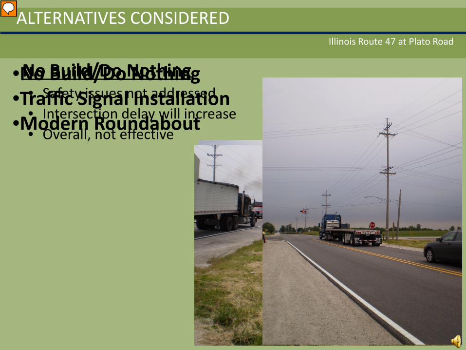
No Build/Do Nothing • Safety issues not addressed • Intersection delay will increase • Overall, not effective
Illinois Route 47 at Plato Road
ALTERNATIVES CONSIDERED
•No Build/Do Nothing •Traffic Signal Installation •Modern Roundabout
Presenter
Presentation Notes
IDOT considered three alternatives to address the purpose and need for the improvement: no build or do nothing alternative, a traditional traffic signal installation, and a modern roundabout alternative. The no build/do nothing alternative would leave the intersection of IL Rte 47 at Plato Road location as-is. This alternative would not address the identified safety issues experienced at the intersection. Delays at the intersection would gradually increase and worsen over time. The standing water in the northwest and southwest corners of the intersection would remain. Overall, this alternative is not effective and does not address the purpose and need for the improvement.
PROPOSED SCOPE OF WORK Illinois Route 47 at Plato Road
ALTERNATIVE 1: SIGNALIZED INTERSECTION
Left turn lanes
Left turn lanes
Paved shoulder
Paved shoulder
•Drainage Improvements •Smoothing Profile •Right-of-Way Needed •Improved LOS •$2.6 Million •Speed limit remains 55mph
Presenter
Presentation Notes
In order to improve the safety and mobility at the intersection, IDOT developed two design alternatives that would meet the purpose and need of the intersection improvement. Alternative 1, Traffic signal installation proposes the following: Adding left turn lanes to both IL Rte 47 and Plato Rd, Providing paved shoulders on both roadways, Clearly defining ditches and removing and replacing a culvert located just south of the intersection on IL Rte 47. The existing culvert is filled with debris and water is not properly draining under the roadway and downstream. Additional right-of-way is needed to accommodate improvements and to implement drainage improvements. The overall LOS improves with little to no delay through the intersection. This improvement will cost approximately $2.6 million dollars. The speed limit on both IL Rte 47 and Plato Rd. will remain 55 mph.
PROPOSED SCOPE OF WORK Illinois Route 47 at Plato Road
ALTERNATIVE 2: MODERN ROUNDABOUT
• 6.0 Acres of ROW • $2.8 Million Dollars • Speed limit remains 55mph
Presenter
Presentation Notes
Alternative 2 proposes to convert the intersection to a modern roundabout. In the plan view, transition zones or gentle approach curves slow traffic on all legs as they approach the intersection. The intersection has been shifted slightly northeast to assist in slowing traffic through the intersection. Channelization is provided with splitter islands on all legs; however, only right turns are required. (FADE OUT THE SPLITTER ISLANDS) Traffic from any direction yields and proceeds thru the intersection when there is a gap in circulating traffic. The profile on both Illinois Route 47 and Plato Road will be modified to improve drainage. Like the signal alternative, the modern roundabout requires acquisition of right-of-way. This acquisition incorporates the larger footprint around the center of the intersection, a shift in the alignment, drainage improvements, and profile modifications. The cost of this improvement is approximately $2.8 million dollars. The speed limit on both Illinois Route 47 and Plato Road will remain 55 mph. Circulating traffic speeds will be reduced to 25 mph.
CONSTRUCTION DETOUR Illinois Route 47 at Plato Road
Presenter
Presentation Notes
In order to accommodate traffic during construction, IDOT evaluated various staging options. The option to maintain traffic on all legs of the intersection is not recommended for both the modern roundabout and the traffic signal alternatives due to the amount of stages that would cause driver confusion and impacts to the adjacent land throughout construction. IDOT evaluated a plan that combines staged construction and closing only the east leg of the intersection in order to minimize the number of construction stages required and the amount of time it would take to build the improvement while maintaining traffic on both directions on Illinois Route 47 and the west leg of Plato Road. This closure would be expected to last approximately 2-4 weeks contingent upon weather, utilities and construction equipment availability. The preferred detour would utilize Dittman Road and Burlington Road; both Kane County Routes. A site visit by IDOT reflected that it would take approximately 10 minutes to get from the east leg of Plato Road to Illinois Route 47 and a total of 15 minutes to get back to the intersection of Illinois Route 47 at Plato Road for vehicles continuing westbound on Plato Road or north on Illinois Route 47 using this detour. Both alternatives will be completed in one construction season.
ALTERNATIVE COMPARISON Illinois Route 47 at Plato Road
SIGNAL ROUNDABOUT NO BUILD
Right Of Way Impact
5.2 Acres 6.0 Acres N/A
Level of Service (Opening Day)
A (AM) / A (PM) B (AM) / B (PM) C (AM) / C (PM)
Construction Cost
± $2.6 M ± $2.8 M $0
Safety Improved
Yes Yes No
Construction Traffic
Staging and Detour Staging and Detour N/A
Driver Familiarity
Common in Illinois New to Illinois N/A
Presenter
Presentation Notes
Exhibits with details for the proposed alternatives are available during the public meeting this evening. In summary, when comparing the alternatives: 5.2 acres of ROW is required for the traffic signal, the modern roundabout requires 6.0 acres, and the No build alternative would have no change in ROW. The modern roundabout requires slightly more ROW than the traffic signal alternative. Both the signal and roundabout alternative for the intersection of Illinois Route 47 will improve the flow of traffic on all legs with an acceptable level of service. Over time, the proposed roundabout design displays an increase in delay through the intersection. The proposed design provides additional lanes as needed in the future with no additional right-of-way to acquire. With the no build alternative, existing delays at the intersection would remain. Expanding the signalized intersection design would require additional right-of-way, relocating and updating the signals to reflect new movements, and additional drainage work. The traffic signal alternative has an estimated cost of 2.6 million dollars. The roundabout is estimated at 2.8 million. Both options improve safety over the existing condition. The no build alternative has no additional cost. During construction, the traffic signal and roundabout can be built using a combination of a staged construction and a detour. This does not apply to the no build alternative as no changes to the intersection would take place. Drivers in Illinois are more familiar with traditional signalized intersections than modern roundabouts.
THANK YOU Illinois Route 47 at Plato Road
• Please browse the exhibits
• Direct questions to the project staff
• Please fill out a comment form
• Comment period ends January 9, 2014
Presenter
Presentation Notes
After this presentation, we invite you to review project exhibits and displays. Project staff is available to discuss and answer any questions you may have. Comments on the alternatives can be placed in the comment box tonight, mailed in, or submitted via email to the addresses listed on the back of your brochure. Your comments must be received by January 9, 2014 to become a part of this meeting’s official record. This concludes the audio visual presentation. Thank you for attending.