iii.3. paraguay - paraná waterway hub · 2013-03-27 · and maritime and river ports within the...
TRANSCRIPT

111
PA
RA
GU
AY
-PA
RA
NÁ
W
AT
ER
WA
Y
III.3. Paraguay - Paraná Waterway Hub
III.3.1. Hub’s Location and Area of Influence The Paraguay - Paraná Waterway Hub was defined by delimiting a general area of influence that incorporates such territories of Argentina, Bolivia, Brazil, Paraguay, and Uruguay that are directly associated with the Paraguay, Paraná, Tieté, and Uruguay rivers. This area of influence is relatively dynamic, since it also relates to the physical location of the projects included in the groups into which the Hub has been divided. The map below shows the current area of the Paraguay - Paraná Waterway Hub.
Map 22 - Location and Area of Influence of the Paraguay - Paraná Waterway Hub
The area of influence is highlighted and includes large areas of the basins of the Paraguay, Paraná, Uruguay, and Tieté rivers. The first three rivers run North to South, forming part of the borders between Brazil and Bolivia, Brazil and Paraguay, Paraguay and Argentina, Argentina and Brazil, and Uruguay and Argentina, while the Tieté river runs East-West across the state of São Paulo, in Brazil, flowing into the lake formed by the Jupiá dam and the Paraná river. The Paraguay - Paraná Waterway Hub’s area of influence is transversally crossed by several (road and railroad) corridors that connect this with other hubs, namely: the Central Interoceanic, Capricorn, and MERCOSUR-Chile Hubs. The area of influence defined for the Paraguay - Paraná Waterway Hub covers 2,167,023 km2, accounting for 16.70% of the total area of the countries that make up the Hub. Its main cities, ports, and border crossings are listed in the table below.

112
Table 52 - Area, Population, Main Cities, Border Crossings, and Maritime and River Ports within the Hub
Countries - Territorial Units Area km2
Population 2008
Main Cities Border Crossings
Maritime and River Ports
BRAZIL 8,514,877 189,612,814
AI de Mato Grosso 1 101,403 995,556 Cuiabá Puerto Limão Cáceres
Mato Grosso do Sul 357,125 2,336,058 Campo Grande Corumbá Corumbá
AI of São Paulo 2 132,792 10,354,707 Campinas Pdte. Epitacio
AI of Paraná 3 58,851 2,440,073
AI of Santa Catarina 4 26,463 1,178,468
AI of Rio Grande do Sul 5 130,852 2,710,573
Area of influence 807,486 20,015,435
BOLIVIA 1,098,581 10,027,643
Santa Cruz 370,621 2,626,697 Santa Cruz Puerto Suárez C. Aguirre
Area of influence 370,621 2,626,697
PARAGUAY 406,752 6,230,000 Asunción Falcón Asunción
Area of influence 406,752 6,230,000 Cdad. del Este C. del Este Pto Villeta
ARGENTINA 2,780,400 39,745,613
Formosa 72,066 539,883 Formosa Clorinda Formosa
Misiones 29,801 1,077,987 Posadas Posadas Posadas
Chaco 99,633 1,052,185 Resistencia Bermejo Barranqueras
Corrientes 88,199 1,013,443 Corrientes Paso de los Libres Corrientes
Santa Fe 133,007 3,242,551 Rosario, S. Fe San Lorenzo
Entre Ríos 78,781 1,255,787 Paraná Pto. Unzué Diamante
Northern Buenos Aires 6 6,740 471,103 San Nicolás Campana
Area of influence 508,227 8,652,939

113
PA
RA
GU
AY
-PA
RA
NÁ
W
AT
ER
WA
Y
Countries - Territorial Units Area km2
Population 2008
Main Cities Border Crossings
Maritime and River Ports
URUGUAY 175,016 3,334,052
8 Departments in the West 7 73,937 1,210,045 Colonia Fray Bentos Nva. Palmira
Area of influence 73,937 1,210,045
Total Countries in the Hub 12,975,626 248,950,122
Total area of influence 2,167,023 38,735,116
Notes: 1 Incorporates the meso-region of Central-South Mato Grosso. 2 Comprises the meso-regions of Presidente Prudente, Aracatuba, San José do Rio Preto, Riberao Preto, Bauru, Campinas, and the administrative region of Botucatu in São Paulo. 3 Includes the North-Western, Western, and South-Western meso-regions of Paraná. 4 Comprises the Western meso-region of Santa Catarina. 5 Includes the North-Western and South-Western meso-regions of Rio Grande do Sul. 6 Incorporates the districts of San Nicolás, Ramallo, Baradero, San Pedro, Zárate, and Campana in Buenos Aires. 7 Includes the departments of Artigas, Salto, Paysandú, Río Negro, Soriano, Colonia, San José, and Canelones del Uruguay. III.3.2. Hub’s Basic Characterization Demography The total population of the area of influence defined for the Paraguay - Paraná Waterway Hub was estimated at 38,735,116 inhabitants in 2008, accounting for a 15.56% of the total population of the countries that make up the Hub. Furthermore, the Hub’s area of influence reached an average population density of 17.87 inhabitants per km2. This indicator ranges from a maximum 77.98 inhabitants per km2 in the area of influence of the state of São Paulo to a minimum 6.54 inhabitants per km2 in the territory of the state of Mato Grosso do Sul, also in Brazil. Economic Aspects The gross domestic product (GDP) for the Hub’s area of influence was estimated at US$ 173,635.3 million at constant 2000 market prices, based on the 2007 statistics calculated by ECLAC for each country and on the GDP share as estimated by each national statistics institute for the territorial units of each country that makes up the Hub. This amount accounts for 14.16% of the total GDP, for the same year, of the five countries within the Hub. The GDP resulting from adding the GDPs of all the Hub’s countries at constant 2000 values has changed positively between 2000 and 2007 by 27.12%, i.e. an annual average growth rate of 3.49%. As to the economic activities in the countries of the region, the sectors that grew the most in the last seven years were the following: trade, restaurants and hotels; financial entities, insurance, real estate, etc.; transport, storage and communications; and construction, in this order. Exports from the area of influence of the Paraguay - Paraná Waterway Hub amounted to US$ 60,033.9 million in 2008, which, compared to the annual figure in 2000 (US$ 20,343.8 million), represents a 195.09% growth in eight years. Furthermore, if the value of exports from the Hub in 2008 is compared to the annual figure of all the exports from the countries that make up the Hub, the former accounts for 21.01% of the latter (US$ 285,750.1 million).

114
In terms of value, 83.55% of the exports from the countries that make up the Hub were extra-regional in 2008, while the exports to the countries of the Hub (i.e. intra-regional) represented 16.45% (US$ 46,998.5 million), whereas in 2000 intra-regional exports were 21.70% of the total exports (US$ 18,674.7 million). Soybeans, whether or not broken, are the most important among the five leading products exported from the countries in the Paraguay - Paraná Waterway Hub, accounting for about 6.17% of the total value of exports in 2008, followed by crude oil (5.74%). Non-agglomerated iron ores and concentrates; oilcake, flours and meals of oil seeds, and other vegetable oil residues; and agglomerated iron ores and concentrates rank third, fourth and fifth, respectively. In 2008, the sum of the five leading products exported from each country accounted for 27.54% of the total value of exports from the countries that make up the Paraguay - Paraná Waterway Hub. The transportation means used for exports from and imports to the countries of the Hub (Argentina, Bolivia, Brazil, Paraguay, and Uruguay), in terms of the volume traded in 2007, were as follows: by sea, 86.66%; by railway 3.60%; by road, 4.02%; by river, 2.11%; by air, 0.20%; and by “other means,” 3.41% of total exports. By comparison, in 2000 international cargo movements by volume to and from the same countries were as follows: by sea, 85.54%; by railway, 3.65%; by road, 5.40%; by river, 2.32%; by air, 0.20%; and by “other means,” 2.89% of total exports. The main economic activities carried out in the territorial units that make up the Paraguay - Paraná Waterway Hub follow the production profiles indicated below: • State of Mato Grosso: Oilseed (mainly soy) complex production-industrialization cluster.
• State of Mato Grosso do Sul: Campo Grande pole: Industrial segments including meat plants, dairies, flours and oils, leather industry, wood industry, textiles, and furniture. Dourados pole: Industrial segments including flours and vegetable oils, meat plants, alcohol and sugar industries, yerba mate, textiles and leather industry. Tres Lagoas pole: Meat plants, dairies, packaging, alcohol, sugar, leather industry, beverages, and wood industry. Corumbá pole: Extractive industries (of minerals, cement, limestone), dairies and meat plants.
• Bolivia, Santa Cruz: Santa Cruz pole: Oilseed (mainly soy) complex production-industrialization cluster, meat plants, dairies, forestry, oil derivatives and natural gas in the refineries of the area. Puerto Suárez-Corumbá pole: Soy derivatives and port services cluster.
• Area of influence of the state of São Paulo: This is a consolidated region. There is a highly developed production and industrialization of citruses (mainly oranges) and sugar cane, with a remarkable dynamism and increase in production. Alcohol production from sugar cane as a complementary fuel is especially important. Cattle and poultry have been strongly developed as well.
• Area of influence of the state of Paraná: Important corn, sugar cane, and cassava production. Cattle and poultry are important as well. Its textile industry is well known internationally. Cellulose and wood-related activities are enjoying rapid growth.
• Area of influence of the state of Santa Catarina: Strong poultry and wood production. Its textile industry pole is internationally important.
• Area of influence of the state of Rio Grande do Sul: Important rice, cattle, and poultry production. Its textile industry is internationally important.
• Paraguay: Central Department and city of Asunción pole: a) Oilseed production cluster; b) Fresh fruit cluster; c) Cotton production-industrialization cluster; and d) Metalworking cluster. Alto Paraná Department pole: Balanced foodstuff cluster based on local soy, corn, and wheat production. Development of wood cluster.
• Formosa: Oil production center. Also some agricultural products, such as cotton and soy.
• Chaco: Cotton production-industrialization complex. Areas with a potential for cattle and soy production.
• Misiones and Corrientes: Wood-cellulose-paper mill cluster. Wood, cellulose paste, and paper production center. Tea and yerba mate cluster. Advanced tea and yerba mate production and industrialization.

115
PA
RA
GU
AY
-PA
RA
NÁ
W
AT
ER
WA
Y
• Entre Ríos and Corrientes: Rice production center. Regional cattle-raising center.
• Santa Fe: (Rafaela-Casilda) Agroindustrial, metallurgical, and metalworking production center, specialized in agricultural machines, agricultural parts, and auto parts. Metalworking cluster. Center for the dairy industry.
• Rosario-Santa Fe-San Nicolás: Oilseed and cereal agroindustrial cluster. Soy convergence, processing, and shipping center. Vegetable oils, flours, and pellets production. Iron and steel industry, chemical and petrochemical industry, and car metalworking industry. The most important Argentine port complex for export operations.
• Uruguay: Colonia - Nueva Palmira pole, agricultural-cattle raising cluster in Uruguay. Port services that grow every year at the pace of an increasing demand from Bolivia and Paraguay for Nueva Palmira port services related to grain cargo. Regional tourism (mainly from Uruguay, Argentina, and Brazil). Paysandú - Río Negro - Colonia pole: Cellulose and wood production cluster, based in Fray Bentos and Conchillas.
Current Infrastructure The Hub’s area of influence comprises economically well-consolidated and relatively less developed areas. This means that there are two clearly distinct types of infrastructure problems in the region. The economically well-consolidated areas impose the need to improve service provision in view of the growing demand for transport. The less developed areas create the need to link marginal regions in order to foster their integration to sustainable development. • The road network of the countries that make up the Paraguay - Paraná Waterway Hub covers 1,980,322
km, of which 14.16% of national roads was paved by the end of 2006. The road infrastructure in most border regions cuts across important natural barriers, such as the Pilcomayo, Paraguay, and Paraná rivers in the Argentine-Paraguayan border, the Paraná river in the Paraguayan-Brazilian border, the Paraguay river in the Bolivian-Brazilian border, and the Uruguay river in most parts of the Argentine-Brazilian and Argentine-Uruguayan borders. Due to these natural barriers, the integration road network obliges international transport to use a small number of bridges that interconnect these countries. Even though route maintenance has improved, the growth of international transport and the structure of the Hub’s road network, which includes bridges and border crossings, result in high transportation costs and integration difficulties.
• Railway transport: The railway network of the countries that make up the Paraguay - Paraná Waterway Hub covers 68,716 km, of which 94.24% are active lines and most of them operate in the area of influence of the Hub. In this area of influence there are railways that connect Argentina and Paraguay, Bolivia and Brazil, Brazil and Uruguay, Argentina and Uruguay, and Argentina and Brazil. In general, railway systems are old and in poor condition; however, the countries that make up the Hub have designed development plans providing for substantial investments to improve and enlarge the railway network.
• The Hub’s river port infrastructure is made up of the seventeen important ports that, listed from North to South, are: Cáceres and Corumbá, Panorama and Presidente Epitacio, on the banks of the Paraguay and Paraná rivers in Brazil, respectively; Central Aguirre Port on the Tamango canal near the Paraguay river in Bolivia; more to the south, Asunción, in Paraguay, on the Paraguay river. Then comes Formosa port, on the Paraguay river, and Barranqueras, Corrientes and Santa Fe ports on the Paraná river; the San Lorenzo/San Martín port complex, in Rosario, and San Nicolás, Zárate and Campana ports, also located on the Paraná river. Finally, Concepción del Uruguay and Nueva Palmira ports on the Uruguay river (in Argentina and Uruguay, respectively). Most ports listed have adequate facilities for the traffic, movement and conditioning of import and export goods. Between 2001 and 2007, the total cargo movement in the four Brazilian ports mentioned has grown by 95.21% (from 3,025,079 tons to 5,905,303 tons). In addition, in the Argentine San Lorenzo/San Martín port complex, cargo movements have grown by 58.33% between 2000 and 2007 (from 28,127,162 tons to 44,533,347 tons).

116
• The river network in the Paraguay - Paraná Waterway Hub’s area of influence is made up of the following components: the Paraguay - Paraná Waterway, the navigable length of which is approximately 3,442 km (between Cáceres and Nueva Palmira, the river stretch governed by the Transport Treaty); the Alto Paraná river, which is divided into two stretches: from Confluencia to Itaipú dam, the river is shared by Argentina and Paraguay and is 632 km long, while the stretch between Itaipú and the mouth of the Tieté river is exploited by several dams; the Tieté river is 1,150 km long navigable between its source and the point where it flows into the Paraná river; and the Uruguay river, whose best navigable stretch is 348 km long (between Salto and Nueva Palmira in Uruguay).
• Airport infrastructure in the Hub is adequate, therefore all the area can be very well connected by air.
• The most important hydroelectric power stations in South America are located in the Hub’s area of influence, and there are projects to build other important dams in the same region. In general terms, this infrastructure does not pose any great problem, but calls for continuing with the task of harmonizing technical standards and structuring energy integration.
III.3.3. The Hub’s Development Potential The area of influence of the Paraguay - Paraná Waterway Hub represents a market of more than 38 million inhabitants along its 2.17 million km2, with a gross domestic product of about US$ 173,635.3 million (87.76% of which is contributed by the Argentine and Brazilian portions of the area of influence). Institutionally speaking, this area is undergoing an 18-year long integration process (MERCOSUR) and is governed as well by the Agreement on River Transport through the Paraguay - Paraná Waterway since 1992. Furthermore, the Intergovernmental Committee of the Waterway (CIH - Comité Intergubernamental de la Hidrovía) was created by the five countries involved with the aim of designing actions and identifying projects and works to improve navigability in order to facilitate transport through the Waterway. The region abounds in iron ore, particularly in the Urucúm and Mutún mines, located in the areas adjacent to the Pantanal (wetland) between Brazil and Bolivia, respectively, the products of which use the river network to reach intra- and extra-regional destinations. Likewise, there are surpluses of hydroelectric energy and natural gas, and agricultural, agroindustrial and industrial production. Given their good prices, these products turn into great opportunities to increase production and intra- and extra-regional exports. • The region has consolidated as well as relatively less populated areas, the latter with great capacity and
potential for development.
• This region is rich and well-balanced in resources of all kinds (energy, agriculture, industries, etc.).
• This is a consolidated Hub in terms of human settlements, use of land, and infrastructure development, across its highly productive territories.
• Improvements in river navigability will result in a substantial reduction of transport costs for intra-regional as well as for extra-regional traffic flows, thus improving the competitiveness of regional products, particularly those coming from the areas located farther from sea ports.
• There is a need to balance upstream and important downstream traffic flows.
• There are adequate conditions to improve regional competitiveness by reducing electricity costs through East-to-West flows and vice versa, depending on circumstances, as soon as the NEA-NOA (Northeastern Argentina-Northwestern Argentina) electric interconnection line becomes operational, which is scheduled for the near future.
• In the mid-term, the Hub’s dynamics will be determined by:
Energy exchange
Increase in river cargo transport and related logistics
Incorporation and development of areas in the Hub associated with the growth of agricultural (soy) production, metalworking industry, and mineral (iron ore) extraction activities
117
PA
RA
GU
AY
-PA
RA
NÁ
W
AT
ER
WA
Y
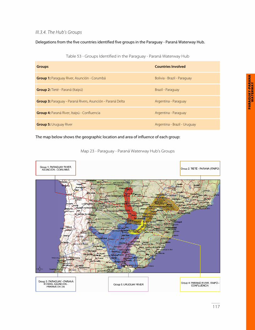
III.3.4. The Hub’s Groups Delegations from the five countries identified five groups in the Paraguay - Paraná Waterway Hub.
Table 53 - Groups Identified in the Paraguay - Paraná Waterway Hub
Groups Countries Involved
Group 1: Paraguay River, Asunción - Corumbá Bolivia - Brazil - Paraguay
Group 2: Tieté - Paraná (Itaipú) Brazil - Paraguay
Group 3: Paraguay - Paraná Rivers, Asunción - Paraná Delta Argentina - Paraguay
Group 4: Paraná River, Itaipú - Confluencia Argentina - Paraguay
Group 5: Uruguay River Argentina - Brazil - Uruguay
The map below shows the geographic location and area of influence of each group:
Map 23 - Paraguay - Paraná Waterway Hub’s Groups
118
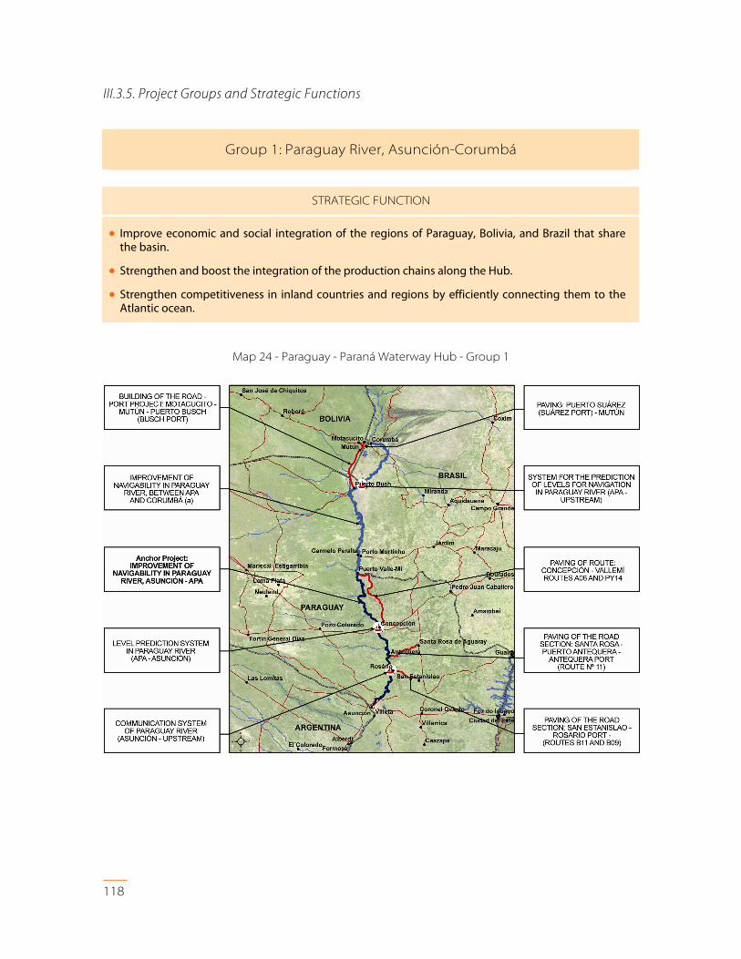
III.3.5. Project Groups and Strategic Functions
Group 1: Paraguay River, Asunción-Corumbá
STRATEGIC FUNCTION
• Improve economic and social integration of the regions of Paraguay, Bolivia, and Brazil that share the basin.
• Strengthen and boost the integration of the production chains along the Hub.
• Strengthen competitiveness in inland countries and regions by efficiently connecting them to the Atlantic ocean.
Map 24 - Paraguay - Paraná Waterway Hub - Group 1

119
PA
RA
GU
AY
-PA
RA
NÁ
W
AT
ER
WA
Y
Table 54 - Paraguay - Paraná Waterway Hub - Group 1: Related Investments
Paraguay - Paraná Waterway Hub: Group 1 Estimated Investment (US$ million)
Building of the Road - Port Project: Motacucito - Mutún - Puerto Busch (Busch Port) 84.0
Paving: Puerto Suárez (Suárez Port) - Mutún 18.8
System for the Prediction of Levels for Navigation in Paraguay River (Apa - Upstream) 0.0
Improvement of Navigability in Paraguay River, between Apa and Corumbá( a) 0.0
Communication System of Paraguay River (Asunción - Upstream) 4.0
Improvement of Navigability in Paraguay River, Asunción - Apa 40.0
Paving of the Road Section: San Estanislao - Rosario Port-(Routes B11 and B09) 33.5
Level Prediction System in Paraguay River (Apa - Asunción) 0.0
Paving of Road Section: Santa Rosa - Puerto Antequera - Antequera Port (Route No 11) 27.0
Paving of Route Concepción - Vallemí Routes A06 and PY14 90.0
TOTAL 297.3
Note: (a) The execution of this project will depend on the decision by a Brazilian court.
120
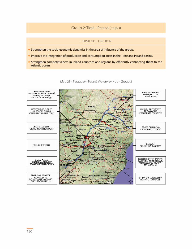
Group 2: Tieté - Paraná (Itaipú)
STRATEGIC FUNCTION
• Strengthen the socio-economic dynamics in the area of influence of the group.
• Improve the integration of production and consumption areas in the Tieté and Paraná basins.
• Strengthen competitiveness in inland countries and regions by efficiently connecting them to the Atlantic ocean.
Map 25 - Paraguay - Paraná Waterway Hub - Group 2
121
PA
RA
GU
AY
-PA
RA
NÁ
W
AT
ER
WA
Y
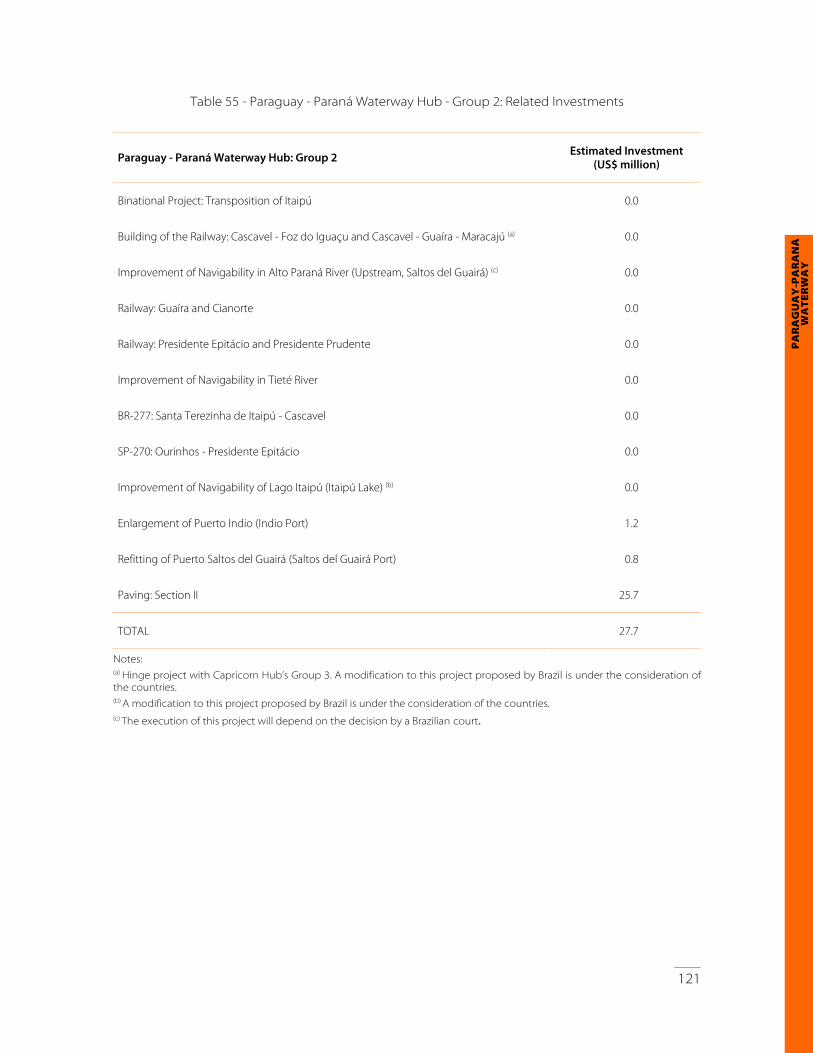
Table 55 - Paraguay - Paraná Waterway Hub - Group 2: Related Investments
Paraguay - Paraná Waterway Hub: Group 2 Estimated Investment (US$ million)
Binational Project: Transposition of Itaipú 0.0
Building of the Railway: Cascavel - Foz do Iguaçu and Cascavel - Guaíra - Maracajú (a) 0.0
Improvement of Navigability in Alto Paraná River (Upstream, Saltos del Guairá) (c) 0.0
Railway: Guaíra and Cianorte 0.0
Railway: Presidente Epitácio and Presidente Prudente 0.0
Improvement of Navigability in Tieté River 0.0
BR-277: Santa Terezinha de Itaipú - Cascavel 0.0
SP-270: Ourinhos - Presidente Epitácio 0.0
Improvement of Navigability of Lago Itaipú (Itaipú Lake) (b) 0.0
Enlargement of Puerto Indio (Indio Port) 1.2
Refitting of Puerto Saltos del Guairá (Saltos del Guairá Port) 0.8
Paving: Section II 25.7
TOTAL 27.7
Notes: (a) Hinge project with Capricorn Hub’s Group 3. A modification to this project proposed by Brazil is under the consideration of the countries.
(b) A modification to this project proposed by Brazil is under the consideration of the countries. (c) The execution of this project will depend on the decision by a Brazilian court.

122
Group 3: Paraguay - Paraná Rivers, Asunción - Paraná Delta
STRATEGIC FUNCTION
• Strengthen and boost the integration of the productive chains along the Hub.
• Facilitate the integration of the Mediterranean countries and regions with the global markets by means of an efficient connection with the Atlantic.
• Improve the productive system in the region as well as the life quality of the people living in the towns included in the area of influence of the group.
Map 26 - Paraguay - Paraná Waterway Hub - Group 3
Table 56 - Paraguay - Paraná Waterway Hub - Group 3: Related Investments
Paraguay - Paraná Waterway Hub: Group 3 Estimated Investment(US$ million)
Binational Project: Improvement of Navigability in Paraná and Paraguay Rivers from Santa Fe to Asunción
0.0
Development of the Infrastructure of the Future Bolivian Tax Free Zone in Zárate (a) 0.0
Building and Refitting of Railway: Asunción - Posadas 0.0
Improvement: Communication System in Paraná River (between Santa Fe and Confluencia) 0.0

123
PA
RA
GU
AY
-PA
RA
NÁ
W
AT
ER
WA
Y
Paraguay - Paraná Waterway Hub: Group 3 Estimated Investment(US$ million)
Belgrano Thermoelectric Station in Campana 650.0
San Martín Thermoelectric Station in Timbúes 500.0
Converter Station in Mercedes 25.0
Recovering of the Section: Paraná - Curuzú Cuatiá 0.0
Recovering of the Section: Tucumán - Rosario 200.0
Recovering of the Section: Zárate - Rosario 0.0
Recovering and Dual Gage of the Railway Section: Corrientes - Monte Caseros 0.0
Reordering of Railway Accesses to the City of Rosario 65.0
Reordering of Railway Accesses to the City of Santa Fe 0.0
Improvement of River Accesses to Ports on the Paraná River 0.0
Deepening of the Draft of Paraná River, from Santa Fe to the River Mouth of the Río de la Plata 110.0
Enlargement of Baradero Port 0.0
Enlargement of Ibicuy Port 0.0
Enlargement of San Pedro Port 0.0
Enlargement of Puerto Diamante (Diamante Port) 0.0
Enlargement and Modernization of Corrientes Port 12.0
Master Plan: Rosario Port 9.0
Refitting of Puerto de Bella Vista (Bella Vista Port) 10.0
Refitting of Puerto Esquina (Esquina Port) 7.0
Restructuring of Santa Fe Port 110.0
Fender System: Barranqueras Port 0.0
Beltway: City of Formosa 25.0
Beltway: City of Santa Fe 200.0
Beltway: City of Rosario 600.0
Paving of National Road (RN) No 11, Section: Junction with Provincial Road No 13 85.0
Paving of National Route No 11, Section: Santa Fe - San Justo 0.0
Paving of Provincial Route No 13, Intersection National Route No 11 - Villa Ángela 90.0
Paving of Provincial Route No 9, Colonia Cano - El Colorado 0.0
Communication System in Paraguay River (Asunción - Confluencia) 3.0
Optimization of Port Terminal System in Great Asunción (Land and River Accesses; Location of Terminals)
0.0
Paving: Villeta - Alberdi 35.0
Refitting and Improvement of the Railway Corridor: Asunción - Montevideo 0.0
Refitting of Formosa Port 0
TOTAL 2,736.0
Note: (a) The final inclusion of the project will be subject to the results of the bilateral discussions.

124
Group 4: Paraná River, Itaipú - Confluencia
STRATEGIC FUNCTION
• Strengthen the socio-economic dynamics in the area of influence of the group.
• Improve the integration of the production and consumption areas in the Tieté and Paraná basins.
• Strengthen competitiveness of inland countries and regions by efficiently connecting them to the Atlantic ocean.
Map 27 - Paraguay - Paraná Waterway Hub - Group 4

125
PA
RA
GU
AY
-PA
RA
NÁ
W
AT
ER
WA
Y
Table 57 - Paraguay - Paraná Waterway Hub - Group 4: Related Investments
Paraguay - Paraná Waterway Hub: Group 4 Estimated Investment (US$ million)
Binational Project: Improvement of Navigability in Alto Paraná 0.0
Rebuilding of Garupá - Posadas Railway (a) 100.0
Encarnación Port (a) 18.0
Restructuring of Puerto Posadas and Puerto Santa Ana (Posadas and Santa Ana Ports) 0.0
Enlargement of Puerto El Dorado (El Dorado Port) 0.0
Enlargement of Ituzaingó Port 27.0
Enlargement of Puerto Itá - Ibaté (Itá - Ibaté Port) 10.0
Locks in Corpus (Binational Project) 0.0
Road Accesses to Encarnación (a) 26.0
Relocation of the Railway Network (a) 90.0
Diverting: Aguapey (a) 64.0
Building of the Kaarendy Port on Paraná River 9.9
Paving of Road Section: Pte. Franco - M. Otaño - Natalio and Access to 9 Ports on Paraná River
142.
Modernization of Puerto de Iguazú (Iguazú Port) 0.0
TOTAL 486.9
Note: (a) Works to complement Yacyretá.

126
Group 5: Uruguay River
STRATEGIC FUNCTION
• Strengthen the socio-economic dynamics in the area of influence of the group.
• Implement an efficient regional system of river and port activities with a view to improving access to the Atlantic.
Map 28 - Paraguay - Paraná Waterway Hub - Group 5

127
PA
RA
GU
AY
-PA
RA
NÁ
W
AT
ER
WA
Y
Table 58 - Paraguay - Paraná Waterway Hub - Group 5: Related Investments
Paraguay - Paraná Waterway Hub: Group 5 Estimated Investment (US$ million)
Binational Project: Improvement of Navigability in the Uruguay River 40.0
Recovering of the Railway Section: Zárate - Posadas 0.0
Improvement of River Accesses to Ports in Uruguay River 0.0
Enlargement of Puerto San Javier (San Javier Port) 0.0
Landing Place: Puerto Alvear (Alvear Port) 0.0
Improvements of Concepción del Uruguay Port 0.0
Building of Lock in Salto Grande (Binational Project) 300.0
Gas Pipeline: Paysandú - Colonia 0.0
Building of the Railway Section: Mercedes - Nueva Palmira Port 50.0
Refitting of the Railway Section: Algorta - Paysandú - Salto 10.0
Design and Building of the Alternative Canal: Casa Blanca 3.0
Improvement of Port Accesses and Infrastructure in Nueva Palmira Port 10.0
New Start-up of the Paysandú Ports, Accesses and Storage Areas 5.0
New Start-up of Salto Ports, Accesses and Storage Areas 0.0
Road Beltway: Nueva Palmira and Land Access System to the Ports 8.0
TOTAL 426.0

128
III.3.6. The Paraguay - Paraná Waterway Hub’s Project Portfolio General Aspects The countries have agreed to include eighty-eight projects in the Paraguay - Paraná Waterway Hub, accounting for an estimated investment of US$ 3,973.9 million, as summarized below:
Table 59 - General Aspects of the Paraguay - Paraná Waterway Hub’s Portfolio
Paraguay - Paraná Waterway Hub
Name Number of
Projects Estimated Investment
(US$ million)
Group 1 Paraguay River, Asunción - Corumbá 10 297.3
Group 2 Tieté - Paraná (Itaipú) 12 27.7
Group 3 Paraguay - Paraná Rivers, Asunción - Paraná Delta 37 2,736.0
Group 4 Paraná River, Itaipú - Confluencia 14 486.9
Group 5 Uruguay River 15 426.0
TOTAL 88 3,973.9
Sector-based Breakdown The following is a sector-based breakdown of the Hub’s projects:
Table 60 - Sector-based Breakdown of the Paraguay - Paraná Waterway Hub’s Portfolio
Transport Communications Energy
Sector / Subsector Number
of Projects
Estimated Investment
(US$ million)
Number of Projects
Estimated Investment
(US$ million)
Number of Projects
Estimated Investment
(US$ million)
Road 20 1,406.0
Railway 16 515.0
River 43 722.9
Multimodal 2 84.0
Energy generation 3 1214.0
Energy interconnection 2 25.0
Communications interconnection
3 7.0
TOTAL 80 2,727.9 3 7.0 5 1,239.0

129
PA
RA
GU
AY
-PA
RA
NÁ
W
AT
ER
WA
Y
Project Typology The Hub’s project typology is summarized in the following tables:
Table 61 - Road Transport Project Typology in the Paraguay - Paraná Waterway Hub
Project Typology Number of Projects Estimated Investment (US$ million)
Enlargement of road capacity 5 110.7
Paving (new works) 8 436.3
Rehabilitation of roads and structures 1 0.0
Bypasses and city accesses 5 859.0
TOTAL 19 1,406.0
Table 62 - River Transport Project Typology in the Paraguay - Paraná Waterway Hub
Project Typology Number of Projects Estimated Investment (US$ million)
Refitting of existing river ports 24 202.0
Improvement of river navigability 17 493.0
Building of new river ports 2 27.9
TOTAL 43 722.9
Table 63 - Railway Transport Project Typology in the Paraguay - Paraná Waterway Hub
Project Typology Number of Projects Estimated Investment (US$ million)
Railway belt 2 65.0
Building of new railway lines 4 50.0
Refitting of railway lines 10 400.0
TOTAL 16 515.0
Table 64 - Communication Project Typology in the Paraguay - Paraná Waterway Hub
Project Typology Number of Projects Estimated Investment (US$ million)
Optical fiber 3 7.0
TOTAL 3 7.0
130
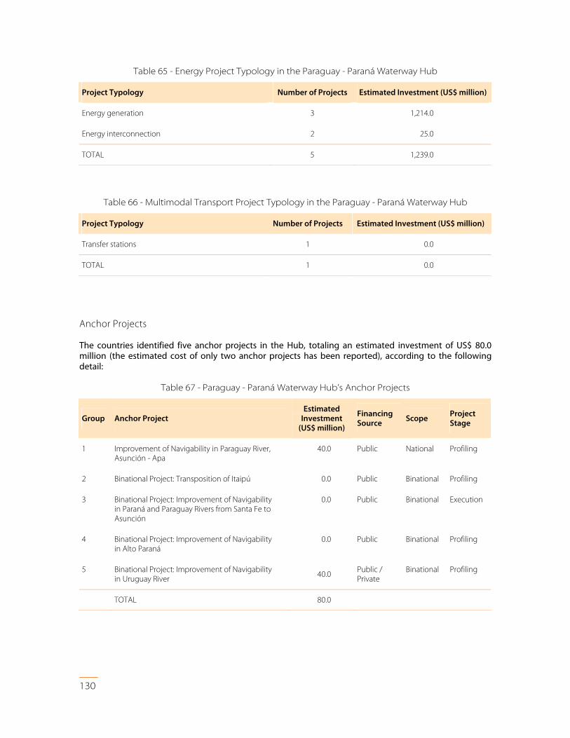
Table 65 - Energy Project Typology in the Paraguay - Paraná Waterway Hub
Project Typology Number of Projects Estimated Investment (US$ million)
Energy generation 3 1,214.0
Energy interconnection 2 25.0
TOTAL 5 1,239.0
Table 66 - Multimodal Transport Project Typology in the Paraguay - Paraná Waterway Hub
Project Typology Number of Projects Estimated Investment (US$ million)
Transfer stations 1 0.0
TOTAL 1 0.0
Anchor Projects The countries identified five anchor projects in the Hub, totaling an estimated investment of US$ 80.0 million (the estimated cost of only two anchor projects has been reported), according to the following detail:
Table 67 - Paraguay - Paraná Waterway Hub’s Anchor Projects
Group Anchor Project Estimated
Investment (US$ million)
Financing Source Scope
Project Stage
1
Improvement of Navigability in Paraguay River, Asunción - Apa
40.0
Public
National
Profiling
2 Binational Project: Transposition of Itaipú 0.0 Public Binational Profiling
3
Binational Project: Improvement of Navigability in Paraná and Paraguay Rivers from Santa Fe to Asunción
0.0
Public
Binational
Execution
4
Binational Project: Improvement of Navigability in Alto Paraná
0.0
Public
Binational
Profiling
5
Binational Project: Improvement of Navigability in Uruguay River
40.0 Public / Private
Binational Profiling
TOTAL 80.0