i·~·i~3·b~l1·t·iibpr- regulatory aspects of submarine
TRANSCRIPT

REGULATORY ASPECTSOF
SUBMARINE TAILINGS DISPOSAL- The Quartz Hill Case History -
U. S. DEPARTMENT of the INTERIOR
Bruce Babbitt, Secretary
U.S. BUREAU of MINES
Hermann Enzer, Acting DirectorOFR 66-93
i·~·i~3·B~L1·t·IIBPr-

REGULATORY ASPECTS OF SUBMARINE TAILINGS DISPOSAL- THE QUARTZ HILL CASE HISTORY -
Prepared forU.S. Bureau of Mines
Alaska Field Operations CenterP.O. Box 20550
Juneau, Alaska 99802-0550Telephone: 907-364-2111
Fax: 907-364-3622
Prepared byHesse Associates
2701 Lake Hollywood DriveLos Angeles, California 90068
March 1993
m

III
REGULATORY ASPECTS OF SUBMARINE TAILINGS DISPOSAL
I - THE QUARTZ HILL CASE HISTORY -
II
By C.A. Hesse and K.M. Reim
I
ABSTRACT
The Quartz Hill Molybdenum Project, in Southeast Alaska, was the first mining project to attemptthe permitting of a submarine tailings disposal system in the United States, since the passageof the National Environmental Policy Act of 1969 and the Clean Water Act of 1977. Over $20million was spent by the project developer in baseline data gathering and in funding thepreparation of the four Environmental Impact Statements and other environmental documentsrequired at various stages of the project between 1977 and 1988.
Because of the timing and a unique set of environmental, legal and regulatory requirementswhich applied to this project, innovative approaches were developed. This report describes thoserequirements and the developments, and gives a full historical account of the campaign forpermitting submarine tailings disposal at Quartz Hill, until denial of the NPDES permit applicationby EPA in September 1990.
The extensive studies done for Quartz Hill suggested that under certain conditions, the selectionof submarine tailings disposal can be the overall environmentally preferred alternative for a miningproject. The Quartz Hill story illustrates the complexity of the existing permitting structure andpoints out the desirability of rationalization to achieve a more effective system.
i

ITABLE OF CONTENTS
Page
ABSTRACT ............................................................. i
TABLE OF CONTENTS ................ .................................. ii
LIST OF TABLES .................................... ................... vi
LIST OF FIGURES ...................................................... vii
LIST OF ABBREVIATIONS ................................................ viii
Section
1.0 INTRODUCTION ............................................. 1
1.1 Scope .................................................... 11.2 Background ............................................... 11.3 Previous Work and Acknowledgements ............................... 2
2.0 PROJECT DESCRIPTION ................. ....................... 2
2.1 Discovery, Exploration and Early Development ......................... 2
2.2 Quartz Hill Area Description ................ ....................... 62.2.1 Environmental Setting ...................................... 62.2.2 Geological Setting .......................................... 62.2.3 Orebody Description ........................................ 7
2.3 Project Description .............................................. 72.3.1 Operating Plan ........................................... 72.3.2 M ining ................................................... 82.3.3 Processing ................ ............................. 82.3.4 Tailings Volume ......................................... 11
3.0 ASSESSMENT OF TAILINGS DISPOSAL ALTERNATIVES ................. 11
3.1 Early History and Initial Evaluation ........................ ...... .. 11
3.2 Legal and Regulatory Baselines ................................... 133.2.1 ANILCA's Congressional Directives ............................ 143.2.2 Exclusion of Quartz Hill from NSPS ........................... 153.2.3 Department of State Fjord Classification ......................... 16
ii

I
4.1 Federal Regulations and Permits ...............A S0 C.at ^ Al eI. Dk il ti+'ipr en, Darmei·t.%. aLQLe Ul ro
ENVIRONI
5.1 Descriptio
I3ia =c uI~ LIIIo ai r=llll . . . . .
MENTAL EVALUATION OF STD OPTIOI
n of Available Options ............
5.2 Environmental Baseline Data Collection .......5.2.1 Summary of Work Completed .........5.2.2 Wilson Arm/Smeaton Bay ............5.2.3 Boca de Quadra Fjord ...............
5.3 The Containment Factor .................
5.4 Comparison of Disposal Sites ..............5.4.1 Physical Characteristics ..............5.4.2 Biological Comparison ...............5.4.3 Cost Comparison ..................5.4.4 Overall Evaluation ..................
CHARACTERIZATION OF TAILINGS EFFLUENTS
6.1 Summary of Work Done ..................
6.2 Characterization of Quartz Hill Tailings .......6.2.1 Ideal Characteristics ................6.2.2 Solid Phase Characterization ..........6.2.3 Liquid Phase Characterization .........
6.3 Toxicity ........................... ....
PROPOSED TAILINGS DISPOSAL SYSTEM ....
... . .. .. ... .. .. ... . 2 1
5.0 NS . .. .
.o .o . . . .
. . . . . o
. . o .° . . .
. . . . . .
.......
.......
. . . . . .
. . . . . .
., . . . .° .
.......
.......
. .. . . .
.......
. . . .. .
.......
. . . .. .
....................... 48
The Delivery System .....................
The Board of Consultants ..................
Tailings Discharge Dynamics ................7.3.1 Near-Field Model ....................7.3.2 Far-Field Model .....................7.3.3 Circulation Models ...................
Predicted Physical Behavior ................
iii
17
20
6.0
7.0
7.1
7.2
7.3
7.4
48
48
51515254
57
3.3 Comparative Assessment of Alternatives .. ................... ....
4.0 REGULATORY REQUIREMENTS FOR SUBMARINE TAILINGS DISPOSAL
22
22
22
27272932
35
3636373737
38
38
39393941
41
. . . . . . . . . . . . . . .
...............
.............................................................
...............
I
i 7.5 Discussion of Comparative Environmental Impacts ..................... 58
8.0 PERMITTING FOR SUBMARINE TAILINGS DISPOSAL ................... 62
1 8.1 Permitting Summary and Chronology ............... ......... .. 62
3 8.2 Environmental Concerns and the EIS Process ......................... 64
8.3 Forest Service EIS Permitting Process ............................... 64
1 8.4 Public Participation ............................................. 67
n 8.5 EPA Permit Application .......................................... 67
8.6 Corps of Engineers Permit Application .............................. 68
I 8.7 State of Alaska Permit Applications ................................. 698.7.1 Office of the Governor, Division of Governmental Coordination ....... 69
S8.7.2 Alaska Department of Environmental Conservation ................ 698.7.3 Alaska Department of Natural Resources ........................ 708.7.4 Alaska Department of Fish and Game .......................... 70
I 8.8 Summary of Agency Coordination .................................. 70
8.9 Mitigation, Monitoring and Reclamation ........................... . . 71
S9.0 THE FINAL EIS AND VARYING INTERPRETATIONS ..................... 71
1 9.1 The Forest Service's Record of Decision ................... ..... .. . 719.2 The Environmental Protection Agency's Position ....................... 739.3 Corps of Engineers ........................................... 74
I 9.4 The State of Alaska ............................................. 749.5 The Developer's Position ........................................ 75
I 10.0 THE PERMIT DECISION ......................................... 77
10.1 EPA's Permit Denial .............................................. 773 10.2 Subsequent Developments ..................................... . 77
11.0 OBSERVATIONS ON THE STD PERMITTING PROCESS ................. 78
I 11.1 Discussion of Permitting Issues .................................. 7811.2 Conclusion .................................................... 79
REFERENCES ........................... ............................ 80
I
I

APPENDICES ..................................................... 85
A Federal and State Laws, Executive Orders and Regulations Applicable to Quartz HillFacility Sites
B Permits and Approvals Required for Mine Development
C Permitting Flow Diagrams for Significant Federal and State Submarine TailingsDisposal Permits
D Permitting Chronology, Quartz Hill Project, Southeast Alaska
E Quartz Hill EIS Significant Issues for Submarine Tailings Disposal
F Anilca Colloquy, Federal Register - Senate, 8-19-80
G About the Authors
v

ILIST OF TABLES
Table Page
2.1 Estimated Quartz Hill Concentrator Effluent ........................... 11
5.1 Quartz Hill Fjord Characteristics ................................... 23
5.2 Mean Heavy Metal Concentrations of Surficial Bottom Sediments .......... 35
6.1 Preliminary Tailings Thickener Effluent Characterization, Solid Phase ........ 40
6.2 Comparative Oxide and Elemental Percentage for Quartz Hill and "Average" IgneousRock ...................................................... 42
6.3 Comparison of Metals in the Tailings Solids with Natural Sediments Levels ... 43
6.4 Concentrator Effluent, Tailings Particle Size Distribution .................. 44
6.5 Preliminary Tailings Thickener Effluent Characterization, Liquid Phase ....... 45
6.6 Mill Reagent Use .............................................. 47
7.1 Suspended Tailings Solids Concentrations Downstream of Island Copper Dischargein Rupert Inlet, BC ............................................. 57
7.2 Comparison of Impacts of Tailings Disposal in the Three Basin Alternatives with aTunnel Creek Mill ............................................. 63
8.1 Quartz Hill Mine Development Permitting Chronology ................... 65
vi
I
1UST OF FIGURES I
Figure Page
2.1 Project Location Map ............................................ 3
2.2 Quartz Hill Location Map .......................................... 4
2.3 General Facility Site Plan .......................................... 9
2.4 Concentrator Process Block Flow Diagram ........................... 10
3.1 Beaver Creek Processing Plant, On-Land Tailings Disposal (Tunnel - Aronitz) . 19
5.1 Geographic Features and Axial Bathymetry for Wilson Arm/Smeaton Bay .... 24
5.2 Geographic Features and Axial Bathymetry for Boca de Quadra ........... 25
5.3 Tailings Disposal Plan and Alternatives .............................. 26
5.4 Oceanographic Sampling Stations .................................. 28
5.5 Schematic Circulation Patterns for Wilson Arm/Smeaton Bay .............. 30 35.6 Pre-Mine Wilson Arm/Smeaton Bay Currents .......................... 31
5.7 Schematic Circulation Patterns for Boca de Quadra ..................... 33
5.8 Pre-Mine Boca de Quadra Currents ............................... 34
7.1 Mixing Chamber Concept for Wilson Arm Outfall Site .................... 49
7.2 Schematic Diagram of the 1:50 Scale Model of Near-Field Tailings Discharge . 53 37.3 Schematic Cross-Fjord Sections of Tailings Density Current and Sedimentation
Process .............. ............... ....... ......... ......... 55
7.4 Profiles of Suspended Solids in Rupert Inlet .......................... 56
7.5 Predicted Tailings Deposition in Boca de Quadra-Discharge in Inner Basin ... 59
7.6 Predicted Tailings Deposition in Wilson Arm/Smeaton Bay ................ 60
8.1 Quartz Hill Project Permitting Schedule .............................. 66
I
I

I
SUST OF ABBREVIATIONS
ADCED Alaska Department of Commerce and Economic Development
ADEC Alaska Department of Environmental Conservation
I ADF&G Alaska Department of Fish and Game
I ADNR Alaska Department of Natural Resources
ANILCA Alaska National Interest Lands Conservation Act
I BC British Columbia, Canada
I Bechtel Bechtel Civil & Minerals, Inc.
Borax United States Borax & Chemical Corporation
I BPJ Best Professional Judgment
U CEQ Council of Environmental Quality
cu yd Cubic yards
Id Day
DEIS Draft Environmental Impact Statement
S DGC Division of Governmental Coordination
I dstpd dry short tons per day
EA Environmental Assessment
I EIS Environmental impact Statement
I EPA Environmental Protection Agency
ER Environmental Report
S ft feet
I FEIS Final Environmental Impact Statement
Fig. Figure
I gpm gallons per minute
I viii
I

IHDPE high-density polyethylene
IDT Interdisciplinary Team
IMS Institute of Marine Science, University of Alaska
kg kilogram
km kilometer
Ib pound
m meter I
mg milligram
mg/I milligrams per litre
MDCAD Mine Development Concept Analysis Document
MOU Memorandum of Understanding
NOAA National Oceanic and Atmospheric Administration
NEPA National Environmental Policy Act
NMFS National Marine Fisheries Service
NPDES National Pollutant Discharge Elimination System
NSPS New Source Performance Standards
ODC Ocean Discharge Criteria
ODCE Ocean Discharge Criteria Evaluation
p. Page
RDEIS Revised Draft Environmental Impact Statement
Ref. Reference
ROD Record of Decision
SEACC Southeast Alaska Conservation Council, Inc. JSIP State Implementation Plan (Clean Air Act)
Six II

I
tons per day
tons per year
University of British Columbia
United States Borax & Chemical Corporation
United States Bureau of Mines
United States Department of Agriculture
United States Forest Service
year
x
STD
stpd
SUP
tpd
tpy
UBC
U.S. Borax
USBM
USDA
USFS
yr
Submarine Tailings Disposal
short tons per day
Special Use Permit

ENGLISH TO METRIC CONVERSION TABLE
FROM TO MULTIPLY BY
acres hectares (ha) 0.045
cubic feet (ft3) cubic meters (m3) 0.0283
cubic yards (yd3) cubic meters (m3) 0.765
dollars per pound ($/Ib) dollars per kilogram ($/kg) 2.204
feet (ft) meters (m) 0.305
gallon (g) liters (1) 3.785
gallons per minute (gpm) cubic meters per second (m3/s) 0.0631
inches (in) meters (m) 0.024
miles (mi) kilometers (km) 1.609
pounds (Ib) kilograms (kg) 0.454
pounds per cubic feet (lb/ft3) kilograms per cubic meter (kg/m3) 16.018
short tons (st) metric tons (mt) 0.907
As of January 1, 1993, the Bureau of Mines converted completely to the metric system. Thisreport was contracted and largely completed during 1992. Therefore most units of measurementuse the English system. The above table can be used to convert English units into metric.
xi
II
IIII
I
I
1
Ji
I
IIII
I

I
1.1 Scope
Between 1976 and 1990, United States Borax & Chemical Corporation (U.S. Borax), as Operatorof the Quartz Hill Molybdenum Project in Southeast Alaska, conducted an intensive campaignto obtain the principal permits for large-scale submarine tailings disposal (STD) into one of twofjords adjacent to a large, low grade molybdenum deposit. The Quartz Hill Project was the firstto apply for a discharge permit based on STD, since passage of the National EnvironmentalPolicy and Clean Water Acts. Because of this and extraordinary environmental, legal andregulatory factors, the development of innovative approaches was required. The Quartz Hill casehistory thus provides a unique example of the development of permitting requirements for STDin the United States regulatory climate of the 1980's. This report is intended as a full but conciseaccount of the history of the effort to permit STD at Quartz Hill.
1.2 Background
Disposal of mill tailings into the marine environment was practiced in a few instances in theUnited States long before the current era of environmental awareness and close regulation. Anotable example is the Alaska Juneau mine, which operated in the first half of this century until1944, discharging gold-mill tailings into the adjacent marine channel. In Canada and other partsof the world, marine tailings disposal had been used more extensively (examples: Britannia mine,British Columbia (BC); Greenex zinc mine in Greenland). Tailings disposal into fresh waterenvironments was also done on some mining projects in Canada and the U.S. (Bluebell Mine,BC; Polaris and Nanasivik in the Canadian Arctic; Stanleigh Uranium and other Elliot Lake,Ontario, mines; Reserve Mining in Minnesota).
As the regulatory climate developed, a few mines in Canada pioneered the successful use ofengineered submarine tailings disposal systems and established ways of working effectively withthe permitting agencies and representatives of the public. The Island Copper and KitsaultMolybdenum mines in BC, in particular, were foremost in developing well-engineered facilities andeffective monitoring methods. Quartz Hill, however, was the first mining project in the U.S. toattempt permitting of STD since passage of the National Environmental Policy Act (NEPA) of 1969and the Clean Water Act of 1977.
Some of the extraordinary legal factors which formed the regulatory framework for the Quartz HillSTD permitting effort included the passage of the Alaska National Interest Lands ConservationAct (ANILCA) in 1980, the exclusion of Quartz Hill from the Clean Water Act effluent limitationguidelines promulgated by the Environmental Protection Agency (EPA) for the Ore Mining andDressing industrial category in 1982, and the 1986 classification by the U.S. Department of Stateof the two adjacent fjords which provided the potential sites for STD, as "internal waters" underjurisdiction of the State of Alaska. These occurrences and their effects are described in moredetail in succeeding sections of this report.
For no other waste disposal project has the same set of conditions applied. For this and otherreasons, such as the environmental sensitivity of the orebody location, the pioneering nature ofthe technology and the difficult regulatory setting, the Quartz Hill STD story is unique.
1
1.0 INTRODUCTION
The technical aspects of STD for Quartz Hill are covered in a separate report being developedfor the U.S. Bureau of Mines (USBM) by the University of British Columbia (UBC) entitled "CaseStudies Related to Submarine Tailings Disposal." That work includes a section on the Quartz Hillproject.
The bulk of the source material used in the preparation of this report came from the USDA ForestService's Final Environmental Impact Statement (FEIS) for the Quartz Hill Project (Ref. 30), thefiles of U.S. Borax, the project developer during the permitting period under consideration (1975-1990), and the files of Cominco Ltd. and its affiliate, the current owner of Quartz Hill. Publicdocuments and documents now in the files of the USBM and the Forest Service were also reliedupon.
The cooperation and assistance of U.S. Borax, Cominco, USBM, the Forest Service, and UBCare gratefully acknowledged.
Subsequently in this document, reference will be made to specific company names or individualnames only where this is important to the context. Personnel will usually be referred to by titleor function, and the mine owner and operator companies as "the Company". The purpose of thisphilosophy is to allow concentration on the process rather than on the personalities andcompanies involved. 32.0 PROJECT DESCRIPTION
2.1 Discovery, Exploration and Early Development I
The Quartz Hill mineral deposit is located on the Alaska mainland about 45 miles east ofKetchikan (Figures 2.1 and 2.2), roughly equidistant from the ends of two fjords named WilsonArm of Smeaton Bay, and Boca de Quadra.
Discovery was made late in the summer of 1974 as a result of regional geochemical surveys Ibeing conducted in Southeast Alaska by U.S. Borax geologists. Mining claims were located inthe Tongass National Forest and later transferred to Pacific Coast Molybdenum Company, anaffiliate of U.S. Borax, which acted as Operator. A single 100 ft deep small diameter core hole 1was drilled in January 1975 to test the continuity of the mineralization. When the initial workyielded encouraging results, a full-scale exploration program was organized commencing in thesummer of 1975, including in later years, a grid of larger diameter core holes of generally about 11000 ft depth. Drilling was to continue every summer through 1983, eventually totalling over268,000 linear feet.
By 1976, the existence of a huge low-grade deposit of molybdenite had been established. 1Planning for development, environmental investigations and permitting activities began. Earlyreconnaissance had indicated the desirability of access and tailings disposal on the Wilson Armside. However, emphasis was shifted to Boca de Quadra because of concerns over the salmon iresources of the Wilson and Blossom Rivers, flowing into Wilson Arm; and the volumetriccapacity of the Wilson Arm/Smeaton Bay fjord system to contain mill tailings from the entiremineral deposit.
2
I
1.3 Previous Work and Acknowledgements

ci.Ec 0CU
001L.
£-

Figure 2.2 - Quartz Hill location map. II
I1I
II
III
IIIIIII

1Application was made in 1976 to the Forest Service for a Special Use Permit (SUP) to constructan access road for bulk sampling up the Keta River valley, from the Boca de Quadra side. Thispermit was granted in November 1977 and a subsequent appeal by the Sierra Club LegalDefense Fund and associated commercial fishing groups was denied.
On December 1, 1978, however, President Carter by Presidential Proclamation withdrew 56million acres of public land in Alaska from mineral entry. This included over two million acres inthe Tongass National Forest around Quartz Hill, which was designated the Misty Fjords NationalMonument. Concurrently, the Secretary of Agriculture cancelled the SUP for road constructionand ruled that access for bulk sampling must be by helicopter.
In January 1979, the Carter Administration proposed Wilderness designation for Misty FjordsNational Monument. A difficult period for U.S. Borax followed, during which the Company wasforced to assume a high-profile lobbying position as it argued its case in Washington. Thisattracted the attention of national environmental groups, which made the Quartz Hill Project a"cause c66lbre".
On December 2, 1980, the rights of a mineral discoverer conferred by the 1872 General MiningLaw were recognized in the passage of the Alaska National Interest Lands Conservation Act (Ref.2), which provided for the development of Quartz Hill under environmental guidelines. ANILCAconfirmed the establishment of the Misty Fjords National Monument of 2,285,000 acres andclassified all of it as Wilderness, except an enclave of 152,610 acres surrounding Quartz Hill. Thispermitted the active development of the project to resume.
By the end of 1980 also, two pre-feasibility studies by outside engineering companies hadindicated the economic potential of the deposit. This was accentuated by the rising price ofmolybdenum, which reached a peak of well over $8 per pound in 1980. The Company decidedto do a full feasibility evaluation and organized a dedicated project group in April 1981. In thesummer of 1981, development drilling continued, the driving of two bulk-sampling aditscommenced, and environmental baseline data gathering was in full swing. Geotechnical work wasperformed, socioeconomic work began and bids for road building were requested. The camppopulation at Quartz Hill reached a peak of about 120 residents. However, opposition and legalchallenges by environmental groups continued. Much of the physical work at Quartz Hill had tobe temporarily halted in September 1981 because of a Court Order which mandated thepreparation of an Environmental Impact Statement (EIS) to cover the Company's 1980-83Operating Plan, which had been approved by the Forest Service.
After completion of this EIS and another to cover bulk sampling, a road from tidewater at WilsonArm was finished in 1983. Bulk samples, totalling about 4800 tons, were removed in August ofthat year and used for process testing and pilot plant runs at the Hanna Research facilities inMinnesota between November 1983 and February 1984.
By mid-1984, the technical work of the feasibility evaluation was virtually completed, and adecision had been made by U.S. Borax that project construction could not proceed immediatelybecause of falling molybdenum prices. Nevertheless, the campaign to secure the principalpermits was continued, so that the next phase of the project would be able to proceed swiftlywhen the economic conditions were right.
5

IThenceforth, environmental baseline data gathering continued sporadically, and permitting Iactivities were carried on into 1990. Details are described in succeeding sections.
2.2 Quartz Hill Area Description
2.2.1 Environmental Setting 3The Quartz Hill area is typical of rugged, west-coast fjord country which has had no previousdevelopment. Except for historical references to occasional use of the coastal areas by nativepeoples and evidence of some old timber cuts along the fjord margins, there is little record ofprevious human usage of the land and no current habitations.
The maritime climate is cool and wet, with approximately 150 inches annual precipitation, little 3sunshine, high humidity and low evaporation. Winters at tidewater are mild, with the ground oftenfree of snow; but at the elevations of the mineral deposit (1400 to 2700 ft), annual snowfall isestimated at between 400 and 800 inches.
Vegetation near tidewater is very dense, west-coast rain forest, but growth rates and timber sizesdecrease rapidly with increasing elevation. At orebody elevations, vegetation is sub-alpine and itimber quality poor when present. There are many open slopes. Soils are generally shallow andcoarse grained, resulting from a relatively short formation period since areal glaciation seven toten thousand years ago. 5Topography is extremely rugged, with over 4000 ft of relief between sea level and the highestridges. The adjacent fjords and river valleys are characteristically glacially scoured, U-shapedvalleys with sills providing an uneven bottom configuration.
Wildlife comprises scattered populations of mountain goat, bear, wolf, beaver, raptors andwaterfowl, most of which (except for goats) are found at lower elevations. Bald eagles nest at the ifringes of the fjords. Bear, goat and beaver have been observed at the orebody elevations.
Rivers flowing into the upper ends of Boca de Quadra to the south, and Wilson Arm to the west, Uare well regarded as salmon spawning streams, particularly the Wilson/Blossom Rivers on theWilson Arm side. These rivers support four of the five Pacific salmon species (chum, pink, silver land king), plus Dolly Varden char and steelhead trout. In addition, there are crustaceans in the Ishallower fjord bottoms and herring use both fjords (particularly Boca de Quadra) as breedingand juvenile rearing areas. jIn the mid-1980's, both fjords supported a limited shrimp and crab fishery, with estimated annualvalue of less than $100,000 (Ref. 31). The upper reaches of Boca de Quadra were generally •regarded as too far away from Ketchikan to support a viable fishery, but there was an activeherring fishery at Kah Shakes, just outside of Boca de Quadra.
2.2.2 Geological Setting
The Quartz Hill molybdenum deposit is located within the transitional zone between a Mesozoicmetamorphic complex to the west and the Mesozoic Coast Range batholith to the east (Ref. 23).The Coast Range batholith is a large mass of igneous intrusive rocks.
6 1J
m

During Tertiary time, plutonic rocks of intermediate composition were intruded into bothcomplexes. The Quartz Hill porphyritic stock was one of these Tertiary plutons and is the primaryhost and presumed source of the molybdenum mineralization in the area. After intrusion about27 million years ago, magmatic forces shattered the crystallized rocks and flooded the fine cracksand openings with mineralizing solutions which deposited molybdenite (MoS) and quartz in aninterlacing stockwork pattern. Probably there was only one principal pulse of mineralization.
The Quartz Hill stock is composed of a series of closely related intrusives. The mineralcomposition of these rocks consists of plagioclase, orthoclase, and quartz, with minor amountsof biotite ranging from 1 to 2 percent. All of the rocks have been affected by fracturing,silicification, potassic alteration, and molybdenite mineralization. Post-mineralization dikes cutacross the deposit from northeast to southwest. A major fault cuts across the deposit trendingnorthwest, but does not appear to have offset the mineralization significantly.
Molybdenum mineralization at Quartz Hill predominantly occurs as very fine-grained molybdenitein quartz veinlets, along fractures and, rarely, as disseminations in the host rocks. The quartzveining and associated molybdenite mineralization occur as a stockwork of veinlets of varioustypes related to a system of intense fracturing. The molybdenite-bearing veinlets are rarely morethan a few millimeters wide. Some quartz veins reach widths of several centimeters, but themolybdenite is usually restricted to narrow sections of the vein.
Pyrite is ubiquitous in the Quartz Hill rocks and occurs as disseminations, veinlets, and coatingsalong joint surfaces. The average pyrite content in the Quartz Hill deposit, however, is onlyapproximately 1 percent. Other sulfide minerals present in very minor amounts includechalcopyrite, galena, and sphalerite. Alteration of the Quartz Hill rocks is widespread and consistsprimarily of silicification and potassic alteration.
2.2.3 Orebody Description
The orebody takes an elongated form with dimensions of about 5000 by 7000 feet in plan, byabout 1700 feet deep. Mineable tonnage is estimated at 1.1 billion short tons at a cutoff gradeof 0.10 percent MoS,, rising to 1.7 billion tons at 0.05 percent cutoff. Grades vary between 0.05and 0.25% MoS 2. Stripping ratio (waste:ore) for a 0.10% cutoff grade is about 1:1. The orebodyincludes a higher grade section of approximately 230 million tons grading about 0.22% MoS,.
Of interest for evaluation of STD potential is the mineralogical composition of the orebody,particularly those minerals which would appear in the tailings. It is notable that the Quartz Hill oreis a "clean" molybdenum ore, with no other economically recoverable minerals. Insolubleminerals, such as quartz, feldspar, biotite and chlorite, comprise over 96 percent of the totalminerals. This subject is treated at greater length in Section 6.2.
2.3 Project Description
2.3.1 Operating Plan
In December 1981, U.S. Borax engaged Bechtel Civil & Minerals, Inc. (Bechtel) of San Franciscoas its engineering contractor for the full feasibility evaluation. With the assistance of Bechtel, aplan for exploiting the molybdenum deposit was developed in 1982, based on the knowledge of
7

I
that time. The plan called for a nominal design operating rate of 35,000 short tons of ore per day 5initially, followed by an increase within the first four to six years (depending on marketdevelopment) to 70,000 stpd through the addition of a second duplicate ore processing line. ISince daily operating peaks could exceed the "name plate" design rate by up to 15 percent, the Itarget for permitting purposes was set at 80,000 stpd. Figure 2.3 shows a generalized plan of thesite facilities utilizing one of the three possible options for submarine tailings disposal.
2.3.2 Mining
Since the ore outcrops on surface, mining was to be done by standard large-scale open-pit Imethods. Quartz Hill was regarded as an unusual mining project for several reasons, whichincluded the remote location, difficulty of initial access, the high precipitation and snowfall, theneed for stringent sediment control and the rugged terrain causing problems in facilities sitingand mine waste disposal. The ore mining rate was planned to be 12.4 million tons per yearinitially, rising to 24.8 million tpy rate in Year 6. High-capacity equipment used would include 26-cu yd electric shovels and 170-ton diesel-electric trucks. The run-of-mine ore would be dumpedinto a gyratory crusher located near the northwest edge of the pit at 1650 ft elevation. The minus8-inch size crushed ore would be discharged to a 60-inch conveyor belt about 20,500 ft long,located in a tunnel leading to a coarse ore stockpile at 585 ft elevation. I
2.3.3 Processing
The concentrator would be located on the north slope of Tunnel Creek valley, about one mileeast of the upper end of Wilson Arm (See Figure 2.3). This site was chosen after acomprehensive evaluation of all feasible project development concepts including tailings Idisposal; the tailings disposal evaluations are described separately in Section 3.0. Some of the iadvantages of the Tunnel Creek plant site include good access, adequate space, and goodfoundation conditions. Compared to sites near the orebody at over 1600 ft elevation, there are galso much lower snow loads because of the milder climate incumbent with the lower elevation Iof between 585 and 410 feet.
From the 365,000 ton storage pile, the coarse ore would be conveyed to two (at full capacity) 5grinding lines, each consisting of a 34-ft diameter semiautogenous mill in closed circuit with two18-ft diameter ball mills. Water for grinding and small quantities of reagents would be added andthe ore ground to a flour-like consistency (about 80% minus 100 mesh), prior to the separationof the molybdenite (MoS) from the gangue minerals in a series of froth-flotation cells.
In the flotation cells, air would be bubbled through the slurry to cause frothing. The collector ireagents added would promote the attachment of the fine molybdenite particles to the airbubbles, causing them to rise to the surface of the cells where the concentrate would beskimmed off. The depressant reagents added would decrease any tendency of the gangue iminerals to adhere to the air bubbles. These minerals report to the tailings. In the processing planproposed, copper and other sulfide minerals would be depressed to improve molybdeniteconcentrate quality. 5A number of flotation steps, some with regrind stages in between, would be required to clean theconcentrate to marketable quality. Figure 2.4 gives a block diagram outlining the process. I
8 I
I

W - -i - m _ - -__1 li
Figure 2.3 - General facility site plan.

MINE
PRIMARYCRUSHER
+iCOARSE ORE
STORAGE IGRINDING IL
4ROUGHER
FLOTATIONtailings
Ii
REGRIND ANDCLEANER FLOTATION
I tailings ,
TAILINGS LTHICKENERS
ITAILINGS DISPOSAL
IN WILSON ARM
Figure 2.4 - Concentrator process block flow diagram.
water -
II
I
IEPI
reclaimed
I
waterIIIII
IU1I
Modified from U.S. Borax, 1983
I!III
4
s --| m I
!F._
MOLYBDENITECONCENTRATE
DEWATERING
BARGE TOMARKET
I r
0
Quartz Hill Molybdenum Project
wa•r --
I
I

11
Final concentrate would be filtered to about 10% moisture and bagged in 3750-lb bags forperiodic shipment by barge to a refinery planned for location at Grays Harbor, WA. The tailingsslurry, consisting of the unwanted gangue minerals drawn from the bottoms of the flotation cells,would be thickened to about 45% solids in two 400-ft diameter thickeners. Reclaimed waterwould be recycled back to the grinding circuits. The thickened tailings would be combined withother minor plant waste streams prior to disposal. The tailings disposal system is described inSection 7.1.
2.3.4 Tailings Volume
Because the molybdenite in the ore averages only about 0.15 percent, the weight of solids in thetailings slurry would almost equal the plant throughput. Tailings quantity at peak throughput of80,000 tpd would be about 79,880 equivalent dry short tons per day. At plant design capacity,tailings quantity would be 69,895 dstpd. Since plant design operating days were established at355 days per year, annual equivalent dry weight of tailings disposed at full design capacity wouldbe 24.8 million short tons. This is an approximation, since ore grades, actual plant capacity andoperating factors could vary somewhat from design. Table 2.1 shows an estimate of liquid andsolid phases of concentrator effluent for the initial and expanded daily peak capacity rates.
TABLE 2.1. Estimated Quartz Hill Concentrator Effluent
Both Cases
Peak Plant Capacity (tpd) Effluent EffluentSolid Phase (tpd) Liquid Phase (tpd)
40,000 39,940 49,800
80,000 79,880 99,700
The plant water would be supplied from a reservoir on Tunnel Creek above the plant, withsupplemental supply from the Blossom River.
3.0 ASSESSMENT OF TAIUNGS DISPOSAL ALTERNATIVES
3.1 Early History and Initial Evaluation
Given the topographic and climatological conditions prevailing in the Quartz Hill area, the appealof STD was obvious to project planners from the start. The development concept of a mill atTunnel Creek with tailings disposal into Wilson Arm, was conceived in the mid-1970's. It wasreadily apparent that this would likely result in less overall environmental impact, and probablyless cost, than on-land tailings disposal or disposal into Boca de Quadra.

However, early concerns were expressed by commercial fishing groups and by some of the State gand Federal agencies charged with fisheries protection. Effect on salmon was the foremostconcern. There were also questions about whether the volumetric capacity of WilsonArm/Smeaton Bay was sufficient to hold the tailings from the entire ore deposit. No accuratebathymetric surveys had been made. The settled density of tailings on the fjord bottom was notknown and the consequences of any tailings spill-over into Behm Canal were a matter forconjecture. IEnvironmental and fisheries groups, supported by some elements within the State agencies, wereopposing road access to the orebody for bulk sampling purposes; and in particular, were againstconstruction of a road up the Blossom River, from the Wilson Arm side. They felt that anydevelopment in the vicinity of the Wilson/Blossom river system would likely reduce its salmonspawning capabilities, which are considered superior to those of the Keta River on the Boca side. IU.S. Borax therefore turned its attention to Boca de Quadra. After completion of an EIS, theForest Service issued a Special Use Permit in November 1977 for a bulk sampling access roadup the Keta River and Hill Creek to the deposit. This decision was appealed by the Southeast IAlaska Conservation Council (SEACC) and the Sierra Club Legal Defense Fund, but the appealwas denied by the Chief Forester in July 1978. jOceanographic work was initiated in Boca de Quadra in October 1978; however, plans for moreactive development were halted by President Carter's December 1978 proclamation establishing gthe Misty Fjords National Monument, and the Secretary of Agriculture's concurrent cancellation Iof the SUP for the Keta access road.
During the hiatus that followed, the Company made comparative engineering and safety Ievaluations of the two competing access routes. The Keta River/Hill Creek route crossed anumber of avalanche paths, which raised the threat of road closures and significant hazards topersonnel in winter. Rerouting was not practicable and snowshed protection would be uncertain Iand expensive. ANILCA, passed in December 1980, called for a Mine Development ConceptsAnalysis Document to be prepared, which would examine the mine development concepts underconsideration, their environmental impacts and the question of access. Studies and Uenvironmental baseline data gathering in Boca de Quadra continued, but it was becomingapparent that the hazards of the Keta River/Hill Creek route could not be tolerated during mineoperations. A Supplemental EIS for road access and bulk sampling issued by the Forest Service Iin April 1982, selected the Blossom River route as the preferred alternative.
However, controversy over route selection continued. In June 1982, the President of U.S..Borax,Dr. Carl Randolph, in order to obtain the backing of the State for the Blossom River route, madea written commitment to the Governor of Alaska, Jay Hammond, that the Company would notplace tailings in Wilson Arm/Smeaton Bay. Consequently, the Company filed with EPA in July 11983, an application for an NPDES permit for tailings disposal in the inner basin of Boca deQuadra.
New information, however, would soon be developed. Fisheries experts advised that, since Ireturning salmon would use only the upper 20 or 30 meters of the fjord waters, spawning andsalmon escapement would be unaffected by STD in either fjord. By July 1982, most members ofthe Forest Service's Interdisciplinary Team (IDT), which included representatives of the concerned
12
4i

I
I11'
13
agencies and a fisheries research organization, were convinced on the advisability of STD overland disposal for Quartz Hill and the Forest Service was acknowledging that STD in WilsonArm/Smeaton Bay would have to be examined in the EIS as one of the possible alternatives.
Further investigations included a definitive bathymetric survey of Wilson Arm/Smeaton Bay by theNational Oceanic and Atmospheric Administration (NOAA) published in February 1984, and testsby the University of British Columbia of the unit volume occupied by settled tailings on the fjordbottom. The results revealed that the below-sill volume of Wilson Arm/Smeaton Bay was indeedlarge enough to contain the tailings from the entire orebody. Other information indicated that themarine impacts from tailings would be minimal and similar in both fjords. Meanwhile, the ForestService issued a Draft EIS for mine development in July 1984, with the middle basin of Boca deQuadra designated as the preferred discharge site.
In the opinion of the Company, the new information on Wilson Arm/Smeaton Bay warranted a re-examination of this fjord as a possible STD site, on an equal footing with Boca de Quadra. Ifapproval for Wilson Arm could be obtained, the impacts of the project could be limited to onedrainage system, impacts of a tunnel portal in the Wilderness would be avoided, a large capitaloutlay would be saved and future operations would be simplified.
In September 1984, Dr. Randolph met with the then incumbent Governor, Bill Sheffield, to presentthe new information and request that the Company and the Forest Service be allowed to evaluateWilson Arm as an alternative STD site. He also offered to bring the state of knowledge for WilsonArm/Smeaton Bay in a number of areas to the same level as that for Boca de Quadra. GovernorSheffield granted the request but did not release Borax from the 1982 commitment. FormerGovernor Hammond was also contacted and indicated his concurrence with the Stateconsidering new information.
This new information was collected and presented In the Forest Service's Revised Draft EIS(RDEIS) issued in January 1986. Based on the information, the Forest Service's preferredalternative for tailings disposal was now Wilson Arm/Smeaton Bay.
In July 1987, the State of Alaska comments on the RDEIS (Ref. 22) supported tailings disposalin Wilson Arm/Smeaton Bay if two conditions were met. First, a monitoring program must bedeveloped to detect any divergence from predicted tailings movements and any violations ofwater quality standards. Second, an acceptable contingency plan must be prepared. Thecontingency plan would enumerate what operational actions could be taken, including relocationof the tailings outfall, if monitoring showed that the discharged tailings were not behaving asexpected. It was still up to U.S. Borax to demonstrate that it should be released from its 1982promise; however, a new Alaskan Governor, Steve Cowper, felt that, "We believe that themodelling of the Smeaton site is the best in the business and has demonstrated that disposalof the tailings can occur in a manner which protects the fisheries water quality, and localenvironment" (Ref. 6). Governor Cowper stated "support for the Smeaton site is conditional upondevelopment of acceptable monitoring and contingency plans".
3.2 Legal and Regulatory Baselines
A unique framework of laws and agency determinations established the ground rules for thepermitting of STD at Quartz Hill. The most important of these included: (1) Congressional

I
directives for Quartz Hill development codified in ANILCA, (2) EPA's exclusion of Quartz Hill from Ieffluent limitations established under the Clean Water Act for the Ore Mining and Dressingindustrial category, and (3) the Department of State classification in 1986 of Boca de Quadra andWilson Arm/Smeaton Bay as internal waters under jurisdiction of the State of Alaska.
3.2.1 ANILCA's Congressional Directives
Signed into law on December 2, 1980, The Alaska National Interest Lands Conservation Act(Ref. 2) confirmed the establishment of the Misty Fjords National Monument of 2,285,000 acresand directed that it be managed by the Secretary of Agriculture. ANILCA provided fordevelopment of the Quartz Hill project by excluding the land needed for facilities from theWilderness classification applied to the rest of the National Monument, but the Act alsoestablished a strict set of environmental standards for project design, construction and operation.Many of these, directly and indirectly, applied to tailings disposal.
Section 503(f)(2)(A) of ANILCA directed that any holder of a valid mining claim within the IMonument be permitted to carry out activities in accordance with "reasonable regulationspromulgated ...to assure that such activities are compatible, to the maximum extent feasible, withthe purposes for which the Monument(s) were established." This (and other Sections of ANILCA)was intended to be interpreted in the light of the report of the Senate Committee on Energy and INatural Resources (Senate Report No. 96-413, Ref. 3), which gives the legislative intent.' Inreferring to the Quartz Hill claims, that Report states (pp. 209-210) "The Committee intends that Ithe evaluation and development of these claims be permitted to continue should that prove Ieconomically feasible, and intends to avoid the implication that mining or related activities areinherently incompatible with the purposes for which the monument was established."
ANILCA did not apply to the adjacent fjords because the fjords had been specifically excludedfrom the National Moment. However, ANILCA recognized the possibility of future use of these Ifjords for STD, but left the decision to be made through existing permitting procedures under Iother laws. Section 503(h)(8) reads:
Designation by section 703 of this Act of the Misty Fjords National Monument Wildernessshall not be deemed to enlarge, diminish, add, or waive any substantive or proceduralrequirements otherwise applicable to the use of offshore waters adjacent to the Monument IWilderness for activities related to the development of the mineral deposit at Quartz Hill, |including, but not limited to, navigation, access, and the disposal of mine tailingsproduced in connection with such development. i
An entire section of the Act (505) was devoted to protection of fisheries on Alaskan NationalForest lands. This section empowered the Secretary of Agriculture to promulgate "reasonableregulations...to maintain the habitats, to the maximum extent feasible, of anadromous fish and iother foodfish, and to maintain the present and continued productivity of such habitat when suchhabitats are affected by mining activities on national forest lands in Alaska." This was to be donein consultation with the State of Alaska and the Secretaries of Commerce and the Interior.
1 An additional aid in interpretation of ANILCA Is the colloquy In connection with ANILCA which appeared n the FederalRegister on August 19, 1980 (Appendix F).
14 1!
*I
I11
15
Specifically for Quartz Hill, Section 505 directed that significant mining operations be inaccordance with approved plans of operation and that such plans include studies for "evaluatingthe water quality and water quantity, fishery habitat, and other fishery values of the affected area".The plans were also to include provisions for evaluating the sensitivity of the fishery habitat atvarious life stages to environmental degradation from mining related activities, identifying the risksto fisheries posed by operations, and preventing significant environmental impacts to the fisheryhabitat.
If he determined that any mining-related activity was harmful to fishery productivity, the Secretarywas directed to require a modification of the project operating plan. If necessary, the Secretarywas empowered to suspend activities for up to seven days unless otherwise required by a UnitedStates district court.
Considered as a whole, ANILCA is a remarkable document. It not only singled out a specificcommercial venture and encouraged development, but also established comprehensive butreasonable provisions to protect fishery values. As stated in the 1979 Report of the SenateCommittee on Energy and Natural Resources to accompany H.R. 39 (Ref. 3), the goal was "tomaintain the habitat of the fisheries producing system so that such system is capable ofproducing at or above current levels of production after the mine has ceased operations."
3.2.2 Exclusion of Quartz Hill from NSPS
In June 1982, EPA published for the Clean Water Act, proposed effluent limitation guidelines andNew Source Performance Standards (NSPS) for the Ore Mining And Dressing point sourcecategory of industry (47 Federal Register 25682 et seq.). According to the Final EIS (Ref. 30, p.A-104), the NSPS rules, as then proposed, would essentially allow no discharge of processwastewaters from molybdenum mills using the froth-flotation process. A source was defined asa New Source if construction commenced after proposal of NSPS, assuming that the proposedregulations would be subsequently promulgated.
Application of this rule to Quartz Hill would have dramatically lessened the practicability of tailingsdisposal, and therefore, project development; because: (1) In the case of STD, economics dictatethat some process waters must accompany the tailings in the discharged slurry. (2) In the caseof on-land disposal in tailings ponds, zero discharge by means of pond water recycling wouldbe practicably unachievable in the climate of the Quartz Hill area, because the excess of annualprecipitation over evaporation would greatly exceed plant requirements.
After attending an EPA sponsored workshop on the proposed rules, the Company and itsconsultants prepared comments and a request for exemption because of Quartz Hill's specialconditions. These were submitted to EPA on August 24, 1982. The submission argued forreformulation of rules that would make provision to allow an STD option to be examined. ForQuartz Hill this might prove to be the more desirable option given the climate, topography,snowslide and seismic hazards, esthetic values and sensitivity of the fishery resources of thearea. The comments concluded that:
The regulations as proposed, pose an unreasonable, burdensome and costly impedimentto the development at Quartz Hill.... In view of the unique environmental, technological,economic and legislative constraints the Quartz Hill Molybdenum Project faces, U.S.

IBorax...requests that EPA revise the proposed regulatory language, as appropriate, to Iprovide for a deferral of definition of Best Available Technology (BAT) and NSPS for QuartzHill until sufficient data becomes available. (Ref. 27) I
On December 3,1982, EPA promulgated NSPS and the effluent limitations for the Ore Mining andDressing category, of which Subpart J (40 CFR 440.100) dealt with the Copper, Lead, Zinc, Gold,Silver and Molybdenum Ores Sub-category. Quartz Hill was specifically exempted from theprovisions of that Subpart. The preamble to the regulations stated:
the Agency believes it would be premature to subject the mine and mill to regulation at Ithis time, before the environmental review process is fully completed.... Accordingly, theAgency is excluding this mine and mill from the regulations applicable to molybdenummines and mills, thereby postponing consideration of the appropriate limitations for this Ifacility until the permit proceedings. (46 Fed. Reg. 54601, Dec. 3,1982)
EPA thus indicated that it would not promulgate special regulations to cover the Quartz Hill 5situation. Instead, the permit writers of Region X would determine appropriate technology-basedstandards on an individual basis in the permit proceeding for an NPDES permit pursuant toSection 402 of the Clean Water Act.
3.2.3 Department of State Fjord Classification
Section 403 of the Clean Water Act requires that proposed discharges into the ocean,"contiguous zone", or "territorial seas" require evaluation by EPA under a set of Ocean DischargeCriteria (ODC). These are supported by regulations in 40 CFR 125, Subpart M. The questionremained, however, as to whether fjords such as Boca de Quadra and Smeaton Bay wereconsidered part of the ocean as defined, and thus subject to these regulations. In a February1984 letter to the Company, the Director of the Water Division of EPA Region X, stated that in theabsence of any State Department determination on the classification of the fjords, EPA would lapply the Ocean Discharge Criteria.
Although the consequences of ODC application were not entirely clear, it was believed by the ICompany's legal consultants that this would impose yet another regulatory hurdle by addingadditional and unnecessary requirements. In addition to requiring review of new technical tquestions about the effects of any discharge into the ocean, EPA's regulations provide that EPAwill not issue a permit unless it can determine that there will not be "unreasonable degradationof the marine environment" (40 CFR 125,123 (a) and (b)). That determination in turn is based onan assessment of technical factors set forth in 40 CFR 125.122. Application of these regulations,designed for discharge of wastes in the open ocean, was felt to be inappropriate because of theclosed nature of the fjord basins.
In February 1986, the Company requested by letter from the Department of State a determinationof the "baseline for measuring the breadth of the territorial sea" in the vicinity of Smeaton Bay andBoca de Quadra. The Department of State responded by defining "closing lines" across themouths of the fjords (Ref. 46). This had the effect of classifying Smeaton Bay and Boca deQuadra as "internal waters" and placing them under the administration of the State of Alaskarather than the Federal government.
16 !«
1
1II!1
17
EPA was therefore no longer legally required to consider the discharge under the more restrictiverequirements of the Ocean Discharge Criteria. This removed a potential roadblock. Nevertheless,EPA felt that the criteria would provide useful guidelines and chose to evaluate the discharge byconducting a Best Professional Judgment (BPJ) evaluation under the guidance of the OceanDischarge Criteria. EPA's final BPJ report was issued in June 1988 and included in the Final EISas Appendix S (Refs. 30 and 48).
3.3 Comparative Assessment of Alternatives
In July 1983, U.S. Borax submitted to EPA an application for an NPDES permit to discharge80,000 tpd of tailings into the inner basin of Boca de Quadra. At the same time, Borax alsoapplied for a Certificate of Reasonable Assurance from the Alaska Department of EnvironmentalConservation (ADEC). In its applications, the Company noted that additional information oncertain items would be developed and submitted as it became available.
Permitting strategy was formulated by the Company and its legal and engineering consultantsin the second half of 1983. It was believed that while EPA had agreed not to apply NSPS to theQuartz Hill facility, EPA was still not convinced that land disposal would not ultimately prove tobe a feasible option. EPA would therefore have to be provided with more-than-adequate technicaljustification, against possible charges of having applied a less rigorous standard to Quartz Hillas compared to the rest of industry. In scoping the project development EIS, for which it was a"cooperating agency", EPA had also requested answers to a number of questions. These wereto be provided in the EIS so that EPA could make an informed decision on the NPDESapplication.
Consequently, Bechtel was commissioned to conduct a full, objective analysis of possible tailingsdisposal methods, as a more detailed extension of its earlier analysis of project developmentconcepts. A two-inch thick report entitled "Comparative Assessment of Tailings DisposalAlternatives" (Ref. 28) was submitted to EPA in December 1983 in support of the NPDESapplication and as a reference document for EIS preparation.
The report evaluated five tailings disposal concepts for the project which recognized constraintsimposed by ANILCA and the Clean Water Act, and provided a side-by-side comparison of theengineering, environmental and cost aspects of the five alternatives. The report was supportedby appendices which provided back-up design data, calculations and more detailed evaluationof specific questions raised in project scoping.
The five alternatives were:
Land Disposal
1. Plant at Beaver Creek, on-land tailings disposal impoundments in Tunnel Creek andAronitz Creek valleys
Submarine Disposal
2. Plant at Tunnel Creek, submarine tailings disposal in Boca de Quadra (the then-proposedproject)

3. Plant at Tunnel Creek, submarine tailings disposal in Wilson Arm/Smeaton Bay I4. Plant at Beaver Creek, submarine tailings disposal in Boca de Quadra 15. Plant at Beaver Creek, submarine tailings disposal in Wilson Arm/Smeaton Bay
The Beaver Creek plant site was to be located about one mile northwest of the ultimate pitboundary, at an elevation of about 1700 ft. Figure 3.1 depicts the first of the above alternatives.
In addition to the five alternatives studied in depth, several other possibilities were looked at but 3rejected and therefore not included in the report. These included disposal in the open ocean bybarge, rejected because of extremely high cost and unacceptable operating problems such asweather delays (Ref. 32).
The discussion of the on-land disposal alternative noted that the feasible sites for tailings storageare volumetrically inefficient because of their wide-mouthed valley configurations with steeplysloping floors. Two sites would be required to contain the tailings from the entire 1.5 billion tonorebody. Rock core dams of 1000 ft and 780 ft height would eventually be needed, ranking thesedams as among the highest in North America. JPower requirements would be higher than for any of the STD options and water supply morecostly. Use of Tunnel Creek valley for tailings disposal would also eliminate the favored TunnelCreek plant site and the personnel housing in conjunction with this site; other locations would Whave to be developed. Construction of the dams would alter the downstream flows and qualityof Tunnel and Aronitz Creeks, resulting in loss of about 1.5 percent of the salmon escapement "in the Quartz Hill area. About 2700 acres of riparian and terrestrial habitat behind the dams wouldalso be lost. The difficulty of dam maintenance in perpetuity after operations had ceased, andseismic risk, were also considered.
Finally, the combined capital and operating cost of the on-land disposal scheme was estimatedat $3.6 billion, more than three times the cost of constructing and operating the entire projectwith STD. UIn evaluating the environmental effects of the STD alternatives, it was stated that the bathymetry Iof the fjords would be significantly affected. Also, some benthic organisms would be smotheredwhile mobile species would be displaced. However, rapid recolonization was expected aftercessation of disposal and water quality impacts during operation would be ameliorated by natural ,sedimentation. Impacts oh the fjord environment, while long term, were not expected to bepermanent.
The conclusions of the study were as follows:
While on-land tailings disposal and subsequent recovery and recycling of run-off from thetailings is a general practice in molybdenum mines in the interior areas of the lower 48United States, climatic and topographic considerations render such a systemuneconomic and environmentally unacceptable at Quartz Hill.
18
,iiil

...... . - ,:.....----:" ... " l. ....." * . ..." . "" " " ....... -"".' " . ..."..-"
'... .:i-'-". W .. ... ..... "'....... ....'. ..
.... "l
.V .." .."" ; "^ I "l ".. ...... "'.
-... i. .......
i IA
**'/ // ** / . ?/ ^ ^i W r-^ D^ 'J^ \\ \ (''* '/''- :. ) . ' i ? ) h \ W '
pipelin *• . ,16i O S I .. n .. ' ...
gllfih . erg ... .....................NX. ·· · · "
S, .. ' .C I,-... j :+,·': ·· ~ .·~:- ·.. ....... -.....-~% .
h4.· 1- 4
Si .. ..... i i ......... ' " -" ', :" ... .•· ......• ,.:::". ,• , :r • .. ... -:::.,.../i"il i::C ::.:::• '" "'.• ~~ ~ I c \ J,' ,t•:. i•,
.•,-': i ..... ". Ii
i-- ,... ..........*. ... ,.--.....J ..'"" :: .- .. ,..-: . / '
.-----. r( L/ .....
·- · iii: i
·"'.~~'·-·iI·-" : \ ii
· · ·-· · ·-
Si ° .......
- -) { .". ..
0 Scale, miles
0 Scale, Ido
contour Inteval, sfeetM m \ .... ---.-• ,.. "- . • ".:.-.' ,: -* * , .. ........ . ..
eaam
. - "i
S. .
, " .- . . I.pumpinr.i
i r.-·-./^
?y I If
I !̂ ·. '"* * .- . .* *\ \,-- *''..;:'-' *
- *.... ,. . \
--...aE:-.;t:%v:..a.
Figure 3.1 - Beaver Creek processing plant, on-land tailings disposal(Tunnel-Aronitz).
·...

0
I* Constraints on mine development, as a result of special recognition of Quartz Hill by I
ANILCA, place particular value on terrestrial and fishery habitat and aesthetics of MistyFjord National Monument, which are not compatible with on-land disposal. g
* Discharge of similar tailings in deep marine waters by projects in similar climatic andtopographic areas in British Columbia have been found to have relatively low impact onbiota, the primary impacts being loss of bottom habitat and smothering of benthos duringproject operation.
* Use of submarine tailings disposal would reduce considerably the adverse impact on the Ivalues of the Misty Fjord National Monument, by reducing terrestrial habitat loss, potentialdownstream impacts on fishery habitat, and long-term aesthetic impact.
* The capital, replacement and operating costs and energy requirements of submarinetailings disposal are significantly less than those of on-land disposal.
U.S. Borax stated as its position that the analysis supported selection of STD for Quartz Hill. ISince the Forest Service had ruled out Wilson Arm/Smeaton Bay in the Record of Decision forthe Road Access and Bulk Sampling EIS, the Company proposed, in December 1983, to disposeof tailings in Boca de Quadra.
The Director of the Water Division, EPA Region X, confirmed in February 1984 that the Quartz Hill AMolybdenum Project was excluded from not only the New Source Performance Standards, but Ialso all effluent guidelines applicable to the Copper, Lead, Zinc, Gold, Silver, and MolybdenumOres Subcategory of Ore Mining and Dressing. He stated that "in lieu of applicable guidelines,the EPA NPDES permit for your project will be based on a best professional judgment (BPJ) Idetermination of best available technology economically achievable (BAT) and best conventionalpollutant control technology (BCT)' (Ref. 47). EPA requested additional information to allow a fullyobjective evaluation in the EIS of land disposal versus STD.
4.0 REGULATORY REQUIREMENTS FOR SUBMARINE TAILINGS DISPOSAL
Outlined in this section are the Federal and State of Alaska regulatory and permit requirementsfor the submarine tailings disposal portion of the Quartz Hill Project. There was also the trequirement to define the characteristics of the tailings slurry to be discharged and the receivingmarine environment, to enable design of the submarine tailings disposal system. Theserequirements are covered in Sections 5 and 6.
The Quartz Hill Project is located in the non-Wilderness portion of the Misty Fjords NationalMonument, within the Tongass National Forest managed by the Forest Service. The Bureau ofLand Management, United States Department of Interior, has delegated its responsibility forminerals management under a Memorandum of Understanding (MOU) to the Forest Service. TheState of Alaska manages the tidelands, submerged lands and "intemal waters", which include allof Wilson Arm/Smeaton Bay and Boca de Quadra fjords. J
The tailings disposal system of an ore milling facility consists of many components, such aspipelines to transport the tailings, a disposal site, and ancillary facilities. While the discussion 5
20 1

herein mentions overall mine development, the primary emphasis is on permitting the tailingsoutfall and discharge of the tailings slurry on the fjord floor, the tailings disposal site.
4.1 Federal Regulations and Permits
There are a large number of federal laws, executive orders and implementing regulations thatapply to the overall construction and operation of the proposed mine and milling facilities. Thoseapplicable to the submarine tailings disposal portion of this project are primarily in the areas ofmining and land management, protection of environmental resources and water quality, whichare highlighted below.
* Mining Law of 1872, as amended* Organic Act of 1897* Fish and Wildlife Coordination Act of 1934* National Environmental Policy Act of 1969* Coastal Zone Management Act of 1972* Endangered Species Act of 1973* Clean Water Act of 1977, as amended* Council of Environmental Quality Regulations, 1979* Alaska National Interest Lands Conservation Act of 1980
A more complete list of laws and regulations applicable to the Quartz Hill Project as of 1983 isin Appendix A.
The primary Federal permitting agencies and their principal permits are as follows:
USDA, Forest Service* Environmental Impact Statement (EIS)* Plan of Operations* Special Use Permits
U.S. Environmental Protection Agency* National Pollutant Discharge Elimination System Permit (NPDES)
U.S. Army, Corps of Engineers* Rivers and Harbors Act of 1899, Section 10* Clean Water Act of 1977, Section 404
A list of permits and approvals for overall mine development for the construction and operationphases is shown in Appendix B. In the permitting of the Quartz Hill Project, permits wereprioritized by the Company; with the first phase devoted to the Priority 1 permits, to be followedat later stages of the project by Priority 2 and 3 permits.
Other Federal agencies such as Fish and Wildlife Service of United States Department of Interiorand National Marine Fisheries Service of United States Department of Commerce, along withvarious State of Alaska agencies, had a review function for these and State permits. Permittingflow diagrams for the above three Federal nermitting agencies are in Appendix C.
21

U
4.2 State of Alaska Regulations and Permits IState of Alaska laws and regulations are in the areas of land and water management, protectionof environmental resources and water quality. Those of significance are listed below, and a morecomplete list is in Appendix A.
* Water Use Act of 1966 3* Environmental Conservation Law of 1971* Alaska Coastal Management Program Law of 1977* Department of Environmental Conservation, Water Quality Standard Regulations (18 AAC
70)* Department of Natural Resources, Tide and Submerged Lands and Water Management
The primary State of Alaska permitting agencies and their principal permits are as follows:
Office of the Governor, Division of Governmental Coordination (DGC)* Coastal Management Program Certification of Consistency
Alaska Department of Environmental Conservation* Certification of Reasonable Assurance l
Alaska Department of Natural Resources* Water Rights* Tideland Lease* Submerged Lands Lease I
Most State and Federal agencies with permitting authority have their proposed permits reviewedby a number of other State and Federal agencies, and this usually includes public review. Flowdiagrams showing the State permitting processes are presented in Appendix C.
5.0 ENVIRONMENTAL EVALUATION OF SUBMARINE TAIUINGS DISPOSAL OPTIONS
Engineering, environmental and cost analyses were made by the Company of a wide range ofconcepts for the location of ore milling facilities and tailings disposal sites on-land, in the ocean 1and in the fjords adjacent to this molybdenum deposit. As described in Section 3.3, on-land Itailings and open ocean disposal were determined to be unacceptable alternatives based onenvironmental and cost factors. The fjord system was chosen as the preferred alternative, .pending further environmental analyses.
5.1 Description of Available Options
The fjords in Southeast Alaska are long, narrow, formerly glaciated valleys, many of which havesills at their outer ends forming closed submerged basins. These closed marine basins arefavorable geomorphologic features for the containment of mill tailings. The fjords with closedbasins near the Quartz Hill mineral deposit are Wilson Arm/Smeaton Bay and Boca de Quadra.
IS22
uL

1I
1
1!1
23
The geographic features and axial bathymetry of these two fjord systems are shown in Figures5.1 and 5.2 (Ref. 30, p. F-3, F-4). The characteristics of these two fjords as to length, depth andvolume are given in Table 5.1.
Table 5.1 a/. Quartz Hill Fjord Characteristics
Fjord / Basin Length, Sill Depth, Maximum Basin Volume Belowmiles feet Depth, feet Sill Depth,
million ft
Wilson Arm / 12.4 425 970 27,440 c/Smeaton Bay
Boca de QuadraInner 4.4 345 560 3,530Central 20.5 280 1280 151,850 b/Outer 12.4 280 1215
a/ Ref. 30, p. 3
b/ Ref. 18, p. 18
c/ Based on calculations from Professional Design Resources, 1985.
Wilson Arm/Smeaton Bay has one sill and one submerged closed basin, whereas Boca deQuadra is longer and deeper than Wilson Arm/Smeaton Bay and has three sills forming threebasins (Figures 5.1 and 5.2). The proposed tailings outfall in Wilson Arm would be near the headof the fjord, with the tailings flowing in a coherent stream to the bottom of the basin. The threepossible tailings outfall alternative sites considered for Boca de Quadra were near the center ofthe inner basin, just downfjord of the inner sill in the middle basin (Figure 5.3), and 2.1 milesdownfjord of the inner'sill in the middle basin (not shown). The latter site was proposed at onepoint by EPA but was rejected as being environmentally unnecessary and inordinately costly.
After evaluation of all the project conceptual factors, the preferred surface mine access route wasfrom Wilson Arm up the Blossom River valley, and the preferred plant site in Tunnel Creek valleyabout one mile easterly of the head of Wilson Arm. Thus, transport of the tailings from the TunnelCreek plant site to the various outfall alternatives would be as follows:
Wilson Arm outfall - 14,000 feet by pipelineBoca de Quadra
Inner Basin outfall - 28,000-ft tunnelMiddle Basin outfall - 38,000-ft tunnel or longer
The surface facilities for the middle basin outfall would be located in the designated Wildernessarea. Figure 5.3 shows the three STD alternatives.

I
I _ _ _ ___
---
_-U
III
IJI
-u
0 5 10 15 20
Figure 5.1 - Geographic features and axial bathymetry for Wilson Arm/Smeaton Bay.
I
0
50so
100
150
200
I350
400
450
500
PLAN VIEW 4I
I
I.II

Modified from U.S. Forest Service, 1988 /
ERNLo 6
0 Scale, miles 10
Scale, kilometers
OUTERBASIN
SILL
WKITE tISLAND
SILL
o 5 10 15 20 25 aU U 40 ou Do ou go
Klometem
Figure 5.2 - Geographic features and axial bathymetry for Boca deQuadra.
0
50
100
150
200
r
350
400
450
500
inlmmmmml•llal
I
le6
A

_..... . -;.... , . ", i ":.... ..'......
1ýl.. .... .. ... ... .. ." " , , ..... . .. ... ....-' .-• E¢ .. ' f : .. ..".: ::.-........ ... ..... ................... .i..... . ... '.
~"...... ', "-6-
.... ...-'...-....'.' , ,.... d , ; ::: ...... ."..-.Wiii•, 8ii . ' -,.,,~' .. i.~: .,...••. ... ... ..
- " . -.... ........ .O~arti
.... .-...... . . ..... :hi d
+ Y/,' \D\~
.... .... ....
: '' .......
".................. .. ...... .........'.............. .... -id .. le
if
Al\
... ··--···i:• .. ..... , :
" • ... ":'7 ........ \
Fueli·i---- "· • it: " • .... ...- -·· '•--i
•~~~" ... .• ,fPlr• i Oi .'/ .:: ;. 2
•..•:., i!i, .... ~' \- • ...•-i\ i ir ,•:: ,----- :i ... .,-".'..i i
FI·'.-"..., _ ,".,\ \.. ," .L. - -: \ .t <& ... ...5. . ............--"" .... " 4../ i : .. B,.... , ..... : - .... , .-**^--*^--·,^l..i ..... ..
. -.. . . .:
. .
-. . , . , . ... .
.. ....
S..... ..--' \ ' .....g
... .. ..... i........
? i Vl,'i..;d im I/ ..I 7.... ....
I . '
;'/ .**' **' .. ..-- . ,,.
...... ..-.-..... . ..............
€[ S
IIIII
£III4IIIIjtI*
Figure 5.3 - Tailings disposal plan and alternatives.
LI

III
Environmental Baseline Data Collection
The objective of the environmental baseline data collection program was to characterize thephysical, biological, social and economic environment of the project area sufficiently to definea preferred mine development plan which would minimize the overall environmental impacts. Forthe submarine tailings disposal component of the project, baseline data collection consistedprimarily of characterizing the physical and chemical oceanography, and the marine biology ofWilson Arm/Smeaton Bay and Boca de Quadra.
5.2.1 Summary of Work Completed
The waters of both fjord systems are vertically stratified with variations throughout the year.Current meters were deployed to measure continuously over the seasons the velocity anddirection of currents at various depths. Up to a total of nine moorings and 25 current meters wereused. In addition, tide level measurements, selected echo soundings, meteorologicalmeasurements and bathymetric surveys were made. Seawater samples were taken seasonallyat the current meter mooring stations throughout the water column. The oceanographic samplingstations are shown on Figure 5.4.
Samples were analyzed for conductivity, salinity, temperature, depth, turbidity, dissolved oxygen,redox potential, carbonate, alkalinity, nutrients (NO,, NO,, NH4, P0), silicates, iron and tracemetals. In addition, shallow cores were taken of the fjord floors to measure sediment physical andchemical properties.
The coastal and marine environs of Wilson Arm/Smeaton Bay and Boca de Quadra may bedivided into five major habitat systems; (1) epipelagic or open water photic (<100 ft deep), (2)mesopelagic, below the photic zone (>100 ft deep to 30 ft of bottom), (3) deep benthic (>100ft deep including bottom and the water to 30 ft above the bottom), (4) nearshore (benthic habitat<100 ft deep and within 300 ft of shore) and (5) estuary region. The epipelagic, nearshore andestuarine habitats are biologically the most important. The epipelagic habitat includes theeuphotic zone extending from the fjord surface to a maximum depth of about 25 or 30 meters.This is the zone through which sufficient light penetrates to permit growth of green plants, andmost of the biological activity occurs within this layer. Estuarine habitat includes the area at themouths of rivers where fresh water and salt water interact with fine grained alluvial sediments.Birds, including bald eagles, frequent the estuaries, and harbor seals are present in the surfacewaters of both fjords, concentrating near the estuaries during periods of smelt and salmonspawning. Whales sporadically visit both fjords.
Coastal and marine biological baseline data were collected as the basis for determining thepotential biological effects of submarine tailings disposal. This is central to the issuance of EPA'sNPDES permit. Data collection included surveys at over 70 stations in each fjord system.Parameters measured often overlapped those of the oceanographic data collection. The followingsurveys were made:
* Hydrography and chemistry* Phytoplankton* Zooplankton* Ichthyoplankton
27
5.2

I
DI = Da•KeWUeI A
WA = Wilson ArmWRO = Wilson River
Modified from U.S. Forest Service, 1988
m River Tidal Flats WBO-- ML -- -- .
WAT1
o sm1n
o 41....
BQ
I// Arm* I. °
EXPLANATION- Boca de Quadra= Mink Bay= Marten Ann= Marten River Outlet= Keta River Outlet
boca ae uuaara I-jora bystemFigure 5.4 - Oceanographic sampling stations.
i a- • • % a -4 - -w O "*nM ws w
U
WA4
Smeato
QT1
)3A
N
nBQ5
Cove (
BQMBMAMROKTO
-BQ9KIte
>tot9BQ1
BQ1 - BQ9G
m1e
.to.
EXPLANATION
SB = Smeaton Bay WAT = WIlsc~ Ar ""
KTO

* Benthos of rocky and soft-bottom intertidal, and rocky and soft-bottom subtidal zones* Benthic recolonization* Fish nearshore, estuarine, and demersal* Estuarine wildlife* Marine mammals
Acute and chronic bioassay programs using actual mill tailings from pilot plant tests wereconducted on selected marine biological species.
A number of contractors were used to collect the marine environmental baseline data, and theirareas of responsibility were as follows:
* Institute of Marine Science, University of Alaska-physical and chemical oceanography, andcirculation modeling.
* VTN Consolidated, Inc. - marine biology and meteorology.* Sea-Lease, Inc. - leased 80-foot vessel, M/V REDOUBT.* E.V.S. Consultants - acute and chronic bioassays.* Seakem Oceanography - seawater trace metal analyses.* Dobrocky Seatech Ltd. - survey of Boca de Quadra and monitoring strategies.* Tetra Tech, Inc. - bathymetric survey of portion of Boca de Quadra.* Rescan Environmental Services Ltd. - analyses of seawater, tailings and technical data.* National Oceanographic and Atmospheric Administration (NOAA) - detailed bathymetric
surveys of Wilson Arm/ Smeaton Bay and Boca de Quadra in 1982.
The Institute of Marine Science, University of Alaska (IMS) collected oceanographic data in bothfjords from October 1978 through December 1983 (Ref. 30, p. 3-33). The initial three cruises usedthe IMS vessel R/V ACONA, and subsequent cruises used the Company's leased vessel, the M/VREDOUBT, first placed in service in August 1979. VTN Consolidated, Inc. collected coastal andmarine biological baseline data from August 1978 through September 1983. Sampling periodsvaried from 5 to 7 per year for 1980-82.
5.2.2 Wilson Arm/Smeaton Bay
The circulation pattern of Wilson Arm/Smeaton Bay is fairly simple, in that this fjord consistsessentially of one basin and one sill. Circulation is dominated by the large tidal range withoccasional high tides exceeding 20 ft, strong vertical density gradients, and seasonal changesin the seas outside the fjord. Bottom water replacement occurs late spring and summer bydenser saline water moving over the sill. In late fall and winter, the basin below sill level isessentially isolated from the outside sea. The above-sill water structure tends to follow thebehavior exhibited outside the fjord throughout the year. A schematic and model of thecirculation are shown in Figures 5.5 and 5.6 (Ref. 30, p. F-8; Ref. 13; Ref.30, p. 3-46; and Ref. 9).
The upper water column is most stable during spring and summer and least stratified duringwinter. The continual discharge of fresh water from the Wilson and Blossom Rivers into WilsonArm comprises only a few percent of the tidal prism. Thus, freshwater-driven estuarine circulationis not a major feature of the fjord circulation.
29

CDE,
E
NOTE: Bold arrows are supported by data.Light arrows are surmised.
kilometers
current meter stations
1)
E
kilometers
Figure 5.5 - Schematic circulation patterns for Wilson Arm/Smeaton Bay.
current meter stations
4
I1IIIIIIIII4IIiiII
!I
I
Ia
I

i - -mrol - - - - -i L soI - -l
W . I I " 1I % 0 Velocity Scales, cm/s -
S, - -- -- 5.0 horizontalS0.25 vertical
1-1
I I I I I I I I I I I I I I I I I I I0 2 4 6 8 10 12 14 16 18 20
Distance, km
Quartz Hill Molybdenum Project
Source Kowalik and Findikakis,1985
Figure 5.6 - Pre-mine Wilson Arm/Smeaton Bay Currents computed by the Tide and Density Driven CirculationModel - Deep Water Renewal Period.
.. - - - - - -- -am em m m m m m m m m m m m m
m m
• " " " - "G" o• " 1 I- -- ' ' %
m ~~40 if so•. m mm m •.,•.
u
20406080
100
120140 9160 '
180
200
220
240260280AMo

I
32 I
The chemical oceanographic program defined the baseline for marine water and sediment quality. 3The high water quality is typical of uncontaminated coastal waters in this region. The dissolvedoxygen within the fjord follows the seasonal water circulation pattem. Maximum oxygenconcentrations of 8-9 mg/I are found in the euphotic zone and minimum concentrations of lessthan 2.5 mg/I are in the deep part of the basin. Organic carbon input is derived primarily fromriver-borne input and in-situ primary production. Heavy metal concentrations of WilsonArm/Smeaton Bay are in the, normal range of seawater, and concentrations in the river waterentering the fjord are low. The sedimentation rate within the main basin is in the range of 0.1 to1.0 cm/year. There is a concentration of heavy metals in the fine sediments on the floor of thebasin, resulting from a natural solubility decrease of incoming dissolved heavy metals whenmixed with the slightly alkaline seawater. The Final EIS may be consulted for further informationon this area (Ref. 30, pp. 3-47 to 3-52).
The marine ecology program examined the five marine habitats, (1) epipelagic, (2) mesopelagic,(3) deep benthic, (4) near shore and (5) estuary region. Areas examined included compositionof the biological communities, food chains, spawning and nursery areas, migration pathways,areas important to critical life cycle stages of organisms, and the existing and potential Irecreational and commercial fishery opportunities. Salmon is the most important fishery. Juvenilesalmonids upon leaving the streams utilize the estuaries for rearing, then pass through the fjord mto enter the ocean. Upon returning to spawn in the streams, the upper waters of Wilson !Arm/Smeaton Bay is their primary pathway from the open ocean to the streams. The details ofthe results of this program are summarized in the Final EIS (Ref. 30, pp. 3-87 to 3-110).
5.2.3 Boca de Quadra Fjord
Three sills divide Boca de Quadra into three basins, the inner, middle and outer basins (Figure5.2). The Keta River, a salmon spawning stream, flows into the upper extremity of this fjord, andseveral other rivers flow into various arms of the fjord. Figure 5.4 shows the sampling stationsfor the physical and chemical oceanographic program.
The circulation pattern is generally similar to that discussed in Section 5.2.2 for WilsonArm/Smeaton Bay. Boca de Quadra has three sills and is longer and deeper than WilsonArm/Smeaton Bay; thus, its circulation pattem is somewhat more complex. Current velocities arelow in the upper waters and inner basin, increase in the lower portions of the middle basin, andare highest in the vicinity of the middle sill at Kite Island. See Figures 5.7 and 5.8 (Ref. 30, 3Appendix S, p. 57; Ref. 30, p. 3-43; and Ref. 10).
The chemical oceanography of Boca de Quadra was found to be similar to Wilson Arm/SmeatonBay, with minor variations. The mean heavy metal concentrations of surficial bottom sedimentsare shown in Table 5.2.
Smeaton Bay heavy metal cooncentrations are similar, but concentrations of manganese appearto be higher in Boca de Quadra. In the chemically basic marine environment, heavy metals tendto precipitate out or be removed from solution by bacteria, which is demonstrated by theconcentration of heavy metal nodules in various areas on the ocean floor in other parts of the Iworld. A summary of these baseline data is in the Final EIS (Ref. 30, pp. 3-47 to 3-52). !
1111

E"
kilometers
E
kilometers
Figure 5.7 - Schematic circulation patterns (generalized) for Bocade Quadra.

I
111
*
cales, cmnsechorizontals vertical
Day 82 of Simulation
=5-20- 40-60- 80-100- 120- 140S160
-180-200-220-240- 260- 280-300
-320- 340-360- 380- 400
Modified from U.S. Forest Service, 1988
Figure 5.8 - Pre-mine Boca de Quadra currents computed by tide and density circulation model-deep renewal period.
.. 4111 W - I i g o IL I- Iam o
I
~fS`~t~,. - C - ** ... a~~~· -'~'`
--CII - --L 4 . . 9....-- - - - ..- C. · C -
rC-Y-- - --- *~c - -r . 4,
cc C.,·.... .,4
- -,r,~/rrr~ )(. .I1. .
Quartz Hill Molybdenum ProjectDistance (km)
5 10 15 20 25 30 35 40 45 50 55I I I I I I I I I I I
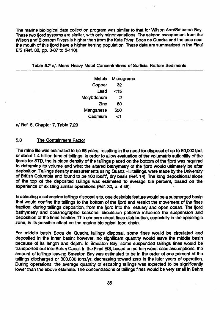
The marine biological data collection program was similar to that for Wilson Arm/Smeaton Bay.These two fjord systems are similar, with only minor variations. The salmon escapement from theWilson and Blossom Rivers is higher than from the Keta River. Boca de Quadra and the area nearthe mouth of this fjord have a higher herring population. These data are summarized in the FinalEIS (Ref. 30, pp. 3-87 to 3-110).
Table 5.2 a/. Mean Heavy Metal Concentrations of Surficial Bottom Sediments
Metals MicrogramsCopper 32
Lead <15
Molybdenum 2Zinc 60
Manganese 550
Cadmium <1
a/ Ref. 5, Chapter 7, Table 7.20
5.3 The Containment Factor
The mine life was estimated to be 55 years, resulting in the need for disposal of up to 80,000 tpd,or about 1.4 billion tons of tailings. In order to allow evaluation of the volumetric suitability of thefjords for STD, the in-place density of the tailings placed on the bottom of the fjord was requiredto determine its volume and what the altered bathymetry of the fjord would ultimately be afterdeposition. Tailings density measurements using Quartz Hill tailings, were made by the Universityof British Columbia and found to be 100 lbs/ff, dry basis (Ref. 14). The long depositional slopeof the top of the deposited tailings was estimated to average 0.5 percent, based on theexperience of existing similar operations (Ref. 30, p. 4-48).
In selecting a submarine tailings disposal site, one desirable feature would be a submerged basinthat would confine the tailings to the bottom of the fjord and restrict the movement of the finesfraction, during tailings deposition, from the fjord into the estuary and open ocean. The fjordbathymetry and oceanographic seasonal circulation patterns influence the suspension anddeposition of the fines fraction. The concern about fines distribution, especially in the epipelagiczone, is its possible effect on the marine biological food chain.
For middle basin Boca de Quadra tailings disposal, some fines would be circulated anddeposited in the inner basin; however, no significant quantity would leave the middle basinbecause of its length and depth. In Smeaton Bay, some suspended tailings fines would betransported out into Behm Canal. In the Final EIS, based on certain worst-case assumptions, theamount of tailings leaving Smeaton Bay was estimated to be in the order of one percent of thetailings discharged or 300,000 tons/yr, decreasing toward zero in the later years of operation.During operations, the average quantity of escaping tailings was expected to be significantlylower than the above estimate. The concentrations of tailings fines would be very small in Behm
35

II
Canal, and probably less than background concentrations of suspended solids from natural Ievents (Ref. 30, p. 4-73). The National Marine Fisheries Service expressed a view that thiseventually "would not likely result in a discernable impact to the fishery resources of Behm Canal"(Ref. 12). 55.4 Comparison of Disposal Sites
5.4.1 Physical Characteristics
The ideal site for submarine tailings disposal would probably include the following characteristics: I
* Provides containment of the deposited tailings* Low current velocities* High salinity gradients* A sharply defined and stable pycnocline* A moderately steep sloping bottom topography at the outfall to below 100 m depth 3
Containment in a fjord or submarine canyon is important primarily to obtain quick deposition andavoid resuspension. The same reason lends importance to the current velocities (particularly near mbottom) and the lack of any upwelling currents caused by tidal impingement. As discussed later,a high salinity gradient with a sharply defined pycnocline (the zone where seawater densityincreases rapidly with depth) will often act as a horizontal barrier to upward migration of tailingsfines. This would keep impacts of STD away from the biologically important euphotic zone. Amoderately steep sloping bottom at the outfall helps keep the tailings fines close to bottom,avoiding "split plume" formation (See section 7.3.1).
The three potential STD sites for Quartz Hill provide all of these characteristics to some degree.In both Wilson Arm and Boca de Quadra, the selected outfall sites have fjord walls whichdescend rapidly at an angle of about minus 25 degrees to the fjord bottoms at depths (oppositethe outfall) of 350 ft for Wilson Arm to 450 ft or greater for the Boca sites. The pycnocline in bothfjords varies seasonally in both strength and position. In the summer from May to October, thefjord water column is stratified with fresher water on top. At this time the pycnocline is strongestin both fjords and fluctuates in depth between 40 and 100 m. With the stable water column whichexists in summer, there is a more definite tendency for the pycnocline to act as a barrier toupward circulation and movement of fines. This keeps fines below the level of the euphotic zone,which in these fjords typically extends to about 25 m in depth. In winter, when vertical mixingtakes place, the pycnocline level deepens and while stratification is less, it is still significant. Ofthe two fjords, Boca de Quadra has the stronger stratification and pycnocline; however, near theKite Island sill, it has also the stronger vertical component of currents causing mixing. It wasconcluded in EPA's PBJ analysis (Ref. 48, p. 80) that fines probably would not appear as highin the water column in Smeaton Bay as they might in Boca de Quadra; however, at comparabledepths where suspended tailings are present, the concentration in Smeaton Bay would generallybe higher. Increased turbidity from tailings discharge was not expected to occur above 50 mdepth in either fjord (Ref. 48, p. 97). '
As discussed in Section 5.3, both fjords provide adequate containment for the tailings. Themiddle basin of Boca, however, provides the greatest factor of safety, in that only 20 percent of j
36

11I11
37
its below-sill capacity would be filled at the conclusion of milling, as compared with 100 percentfor the inner basin and 78 percent for Smeaton Bay (see Table 7.2).
5.4.2 Biological Comparison
The following is excerpted from EPA's BPJ Evaluation using Ocean Discharge Criteria (Ref. 48).
"There appear to be no significant differences in total primary phytoplankton productivity orzooplankton abundance between the fjords....Boca de Quadra appears to be generally morevariable in plankton productivity and abundance due to its greater size and environmentalheterogeneity" (Ref. 48, p. 81).
The economically important epifauna, such as Dungeness crab and shrimp, are most abundantat the shallow depths of both fjords. One of the largest herring spawning grounds in SoutheastAlaska occurs at the mouth of Boca de Quadra. Both fjords are important herring rearinghabitats, but Boca de Quadra probably has relatively greater density and abundance of juvenileherring because of its proximity to the spawning grounds and its larger size.
"The tributaries entering Wilson Arm support a much larger salmon run than tributaries to Bocade Quadra....The estuaries and nearshore areas of both fjords are also important rearing habitatsfor juvenile salmon, which occupy the upper 20 m of the water column. Certain demersal fishspecies (e.g., walleye pollock and slender sole) are substantially more abundant in shallow areasof Wilson Arm and Boca de Quadra inner basins than in the deeper areas..." (Ref. 48, p. 82).
As previously noted, fisheries experts agreed that salmon would not be affected by STD at anyof the alternative sites.
5.4.3 Cost Comparison
In the mid-1980's, U.S. Borax estimated the cost differential between tailings disposal in WilsonArm and Boca de Quadra middle basin to be $59 million in capital cost, plus $1.6 million inannual operating cost. This represented the additional expense for driving a 38,000-ft tunnel tothe middle basin and added facilities at the Boca de Quadra portal, plus additional pumping andlabor costs for servicing the remote facilities. When the cost of financing the additional capitalwas added, the equivalent increased expense in 1984 dollars for producing each pound ofmolybdenum was estimated to be 55 cents.
This is a significant figure with regard to consideration of the risk of closure of the operating mineduring periods of fluctuating molybdenum prices. With the break-even cost 55 cents per poundhigher, the operation would be forced to shut down earlier and remain closed longer, causingan adverse socioeconomic impact on the Ketchikan area.
5.4.4 Overall Evaluation
Several evaluations of the relative merits of the three STD sites were made by RescanEnvironmental Services between March 1984 and October 1985 (Ref. 15). These evaluationsaddressed all facets of tailings disposal including tailings transport to the outfalls, outfall design,
I

II
tailings behavior and dispersal patterns in the marine environment and the ecological significanceof each component.
For the March 1984 report, twenty indices were developed for each basin to indicate relativebiological productivity. Comparison indicated that "there is no statistically significant differencebetween biological productivity of the Wilson Arm/Smeaton Bay system and the Boca de Quadracentral basin. The inner basin of Boca de Quadra was found to have slightly lowerproductivity....Thus, it was concluded that there is little to distinguish a preferred option onecological grounds" (Ref. 16).
After considering new information on Wilson Arm/Smeaton Bay, the July 1985 evaluation notedthat while deep water movements could cause some resuspension at depth, "there are noindications that resuspended material would circulate into the euphotic zone in any of thebasins...the data supports a conclusion that suspended sediments will not encroach on theeuphotic zone and, indeed, that nearly all fine tailings would remain below a depth of 60 meters.The new information on the Wilson Arm/Smeaton Bay system thus allowed us to conclude thatthis basin is the preferred alternative for submarine disposal of tailings from the Quartz Hill IProject."
The Rescan evaluations were done by a team of eight internationally known specialists in marine !ecology, oceanography, sedimentology, marine biology, fisheries and tailings system design andoperation; several of whom had been involved as independent reviewers of the monitoring gprogram for the Island Copper STD operation.
6.0 CHARACTERIZATION OF TAIUNGS EFFLUENTS 56.1 Summary of Work Done
Much research and test work was done at various stages during the Quartz Hill project idevelopment to define the process and reagents, establish percent recovery, provide designinformation and economic data for the feasibility evaluation and to characterize the effluents fromthe plant. The testing included both bench scale and pilot plant tests. Representative samples Jof plant feed material were obtained at various times from diamond drill core splits, several tonsof ore samples flown out prior to completion of road construction, and about 4800 tons of bulksamples of various ore types removed in August 1983 from the two adits driven into the orebody. I
The bulk samples were treated in a series of pilot plant tests conducted at Hanna MiningCompany's Research Center in Minnesota between November 1983 and February 1984. Thisinformation provided much of the data for the Final EIS. Other data were provided by smallerscale process testing done by the U.S. Borax Research Corporation at Anaheim, California. Anumber of specialist consultants and research organizations were also utilized. From theseprocess tests were obtained representative samples of plant tailings, which in turn were used for 3other tests.
In addition to the process research, other investigations included mineralogical and chemical .determinations, tailings slurry rheology, tests on settled tailings density, reagent toxicityinvestigations, and acute and chronic bioassays of the tailings samples. Literature searches were gmade on all aspects of STD. Field visits were made to operations that were using or had used
38 3

II1111
STD successfully; these included AMAX of Canada at Kitsault, BC and the Island Copper Mineon Vancouver Island. A data exchange program was arranged with the latter.
The objective of these efforts was to be in a position to provide the best possible information forproject evaluation and permitting purposes, a part of which was the characterization of thetailings effluent.
I 6.2 Characterization of Quartz Hill Tailings
I 6.2.1 Ideal Characteristics
A list of desirable characteristics of a slurry for possible disposal into the submarine environmentcould be summarized as follows:
Solid phase:SSimple mineralogy, primarily non-reactive
* Fresh and unalteredSLittle or no soluble constituents* Low in heavy metals content
SSimilar to erosional material already in the water* Coarse grind, easily settleable
SLow in fines or slimes
I Liquid phase:SLow in dissolved heavy metals
* Low in other dissolved toxic constituents* pH in neutral range
STemperature close to receiving medium* Specific gravity close to seawater
The importance of the specific gravity is to minimize the possibility of a gravity separationI between a lighter, freshwater slurry constituent and the denser, seawater receiving medium. This
could cause fines to rise in a freshwater plume towards surface. In practice, this risk is minimizedby adding seawater, in the mixing chamber near the outfall, to the slurry as discharged from theSmill. Mixing ratios of seawater:slurry of from 1:1 to up to 6:1 could be used.
The characterization of the Quartz Hill tailings, both solid and liquid phases, which resulted fromI the extensive test programs is summarized in the Final EIS (Ref. 30).
6.2.2 Solid Phase Characterization
I Table 6.1, from Appendix A of the FEIS (Ref. 30, p. A-42) shows a chemical balance and amineralogical balance of the solid phase of Quartz Hill tailings, based on pilot plant data. It isinteresting to note that these data are closely comparable with similar data obtained at an earlier
* time, from different ore samples and different test runs.
In this representative sample, insoluble non-reactive minerals comprised 96 percent of the total.* Few alteration minerals, which tend to form slow settling fines or slimes, were present. Heavy
« "__I

TABLE 6-1 &/THICKENER EFFLUENT CHARACTERIZATIONSOLID PHASE
Tailings ConcentrationWeight Percent 1/Component
Chemical Balance
Silicon dioxide (Si0 2 )Aluminum oxide (A1203)Iron (total) (Fe)Magnesium oxide (MgO)Calcium oxide (CaO)Sodium oxide (Na20)Potassium oxide (K20)Carbon dioxide (C02)Others [Ti02 (titanium dioxide), P2 05
(phosphorus pentoxide), MnO2 (manganesedioxide), and H20 (water)]
Mineral Balance
QuartzFeldspar (total)BiotiteChloriteMolybdenitePyriteMagnetiteCalciteOthers
1/ Typical weight percents are from nine wholemineralogical/chemical analyses of tailings
77.011.4*1.20.30.53.25.00.4
0.5TOIT
3460210.0210.70.80.48
rock analyses and tnesesamples.
Source: U.S. Borax 1984a with modifications by Stine 1984.
a/ Ref. 30, p. A-42
40
II
II1IaIIa
1I
I1I
I
ia
PRELIMINARY TAILINGS

II1II
41
metals other than molybdenum were present in only small or trace amounts. Sulfides were lowand there were almost no soluble oxides.
Except for the presence of anomalous amounts of molybdenite, the ore-forming rocks are verysimilar to the average igneous crustal rocks of the Earth. The erosional products from these aretransported by rivers naturally to the sea along the west coast of North America by the millionsof tons annually and, along with organic material, form the natural sediment currently existing onthe fjord bottoms. Table 6.2 gives a comparison between the average igneous rock and expectedQuartz Hill millfeed (Ref. 20). Dr. J.R. Snook of Eastern Washington University, who did amineralogical examination of the Quartz Hill ore types, concluded in 1982 that "the ore rock isquite uniform in both its physical and chemical properties, which simplifies the predictability ofwaste materials and metal recovery. The ore lacks significant amounts of objectionable elements,which should eliminate most environmental concerns. It is evident from these facts that most ofthe problems involving tailings disposal will be concerned with the grain size and volume of thetailings to be handled." (Ref. 20).
Table 6.3 gives comparisons of the metals in the tailings solids with natural sediment levels inthe Ketchikan area and other west coast points. In Table 6.3, the average copper content of theQuartz Hill tailings solids is 26.0 mg/kg (parts per million), as compared with an average of 31.0for the Southeast Alaska and British Columbia locations and 70 for the Earth's crust (Ref. 28).
Table 6.4 shows the particle size distribution of tailings from six bulk sample pilot plant tests in1983. The target grind was 20 percent plus 100 mesh, which is relatively coarse. Percent passing10 micron size was 18.0; this is the less easily settleable portion which could be advected byfjord currents.
6.2.3 Lquid Phase Characterization
The liquid phase of the tailings slurry consists of the plant water remaining with the tailings afterpassing through the thickeners, or about 55 percent of the slurry by weight. At the designoperating rate, the amount of liquid phase discharged would be about 3,700 tons per hour. Thisstream would be untreated except for possible pH adjustment with lime, and flocculation topromote faster fines settling.
Table 6.5, from the Final EIS (Ref. 34) gives the liquid phase characteristics prior to mixing withseawater. Temperature and pH would be close to fjord conditions after seawater addition ofbetween 1:1 and 4:1 (seawater to slurry). The calculations in the Final EIS were based on anassumed dilution of 1:1 by weight, which corresponds to approximately 2:1 by volume forseawater to liquid portion of the effluent. This is the minimum that would be used in practice.
6.3 Toxicity
Perhaps the primary concern about tailings effluent discharge was the potential toxicity of theeffluents to marine biota and, through the food chain, to humans. The toxicity is influenced notonly by dissolved (or leachable) constituents introduced through the ore, but also throughprocess reagents and any other waste streams added to the tailings discharge. The ultimate testsare bioassays conducted on living organisms in representative samples of the projected tailingseffluent.
I

Table 6.2
Comparative Oxide and Elemental Percentages
for Ouartz Hill and "Average" Ianeous Rock
(after Snook) (Ref. 20)
QuartzHill
78.08
11.52
0.29
0.59
0.24
0.39
2.98
5.09
0.0018
0.0003
0.001
0.0005-0.002
0.0005
0.00002
0.00002
0.15
59.14
15.34
3.08
3.80
3.49
5.08
3.84
3.13
0.003
0.0002
0.002
*0.0065-0.0094
0.0001
IgneousRock
Si02
A1 20 3AlO3
Fe2 ,3
FeO
MgO
CaO
NaO0
K20
Cu
w
Pb
Zn
Sn
Au
Ag
Mo
42

=a O s- m m- o __ M go-- g M W
Samole Data
Earth Crust
Ketchlkan QuadrangleStream Sediment Mean
Std. Dev.
Petersburg Area,Stream Sediment
Boca de Quadra Sediment,inner basincentral basin
Rupert Inlet
S. Calif. Coast197719801980
Ouartz Hill TaillncsSamole L•f I-II
Sample N1D7S9--31
Sample r4)79--10i
Environmental Report
Sample LCT-12
Ave.Max.Ave.
LowAve.High
Reference
(Burllng)
(USDE)
(USGS)
(Burrell)
Table 6.3 a/
COMPARISOH OF METALS IH THE TAILINGS SOLIDSWITH NATURAL SEDIMEHTS LEVELS, mg/kg
As Cd Cu Fe ! Mn
S 0.15 T0 50,000 0.5 1,000
12.5 6.2 35.7 60,30023.4 2.8 23.9 11,600
23.5
(Waldichuk) S
(Bascom)
IU.S.Borax)(U.S.Rorax)(U.S.Borax)
IU.S.Borax) C0.2(U.S.Borax)
(U.S.Borax) <..0
(U.S.Borax)
(U.S.Rorax) 0.61(U.S.Dorax)
3029
2 44
.33 8.31.4 31
.6 10
10II43
0.03 40
41.0 20
22
0.5 29.9
2,00012,200
ISO496
.06 640
9,40014,90321,300
10,000
10,000
14,900
4669
142
160
100 120
62
374 60.
a/ Ref. 27, p. A-24
Mo
IS
NI
80
30.214.8
Pb
16
19.5130
25
6.11212
3II22
30
20
II
S.6
7n
132
15474.6
It.7
41S6
II
34
436246
I13042
11IC
<20
30
20.1
2 40
123520
26
20
3 9.8

U.S. StandardUpper Limits, Sieve Equivalent Weight PercentMicrons No. Passing 1/
595
297
210
149
105
74
53
44
37
30
25
20
15
10
5
28
48
65
100
150
200
270
325
400
98.8
95.1
90.0
80.9
69.4
53.0
46.3
42.4
38.9
35.2
32.4
28.5
23.4
18.0
10.7
1/ From analyses of samples from the Bulk Sample Pilot Plant grindingtests on October 14, 15, and 18, November 30, December 1 and 19,1983 (six tests). The grinding target for the concentrator is 20percent plus 100 mesh (149 microns).
Source: U.S. Borax 1984a.
a/ Ref. 30, p. A-48
TABLE 6.4 a/
CONCENTRATOR EFFLUENTTAILINGS PARTICLE SIZE DISTRIBUTION
IIIIII1II
44
1IIIIIII1II

TABLE 6.5 a/PRELIMINARY TAILINGS THICKENER EFFLUENT CHARACTERIZArHON
LIQUID PHASE
Approximate Concentration(in micrograms per liter
Parameterli unless otherwise noted)
pH (standard units)./ 8.7Temperature ('F)2/ 51Total dissolved solids mg/14/ 160Conductivity (mho/cm) 5 l- 256Dissolved oxygen (mg/1).J5 7Total organic carbon (mg/1) 5/ 6/ 13Arsenic/ 6.8Cadmiui/ 15Chromi u_./ 34Copperi/ 35Iro n/ 1790Lead_/ 120Manganee7/ 330Mercury / 1.2Molybdqqunu/ 1080Nickeli/ 290Selenium7/ 6.6Silver7 7Zinctl 77
Note: The concentrator would produce about 3,780 tph (80,000 tpd) ofsolids and 3,700 tph of water from thickener underflow. NO furthertreatment of this stream is planned after possible pH adjustment andflocculation. This characterization does not include washdown water,power plant wastewater, adit drainage water, runoff or others.1/ Prior to transport and mixing with seawater."/ pH value is from Bulk Sample Pilot Plant testing without lime addition
(hourly tests for four days).3/ Temperature is an engineering estimate of the tailings before mixing
with seawater.4/ Total dissolved solids was calculated from conductivity, based on 16
analyses of conductivity.5/ Conductivity, dissolved oxygen, and total organic carbon values are
from Bulk Sample Pilot Plant testing from October 24-27, 1983.Dissolved oxygen based on 16 analyses.
6/ Total organic carbon is the parameter which indicates the amount ofresidual reagents. Value based on three analyses.
7/ From analyses of the tailings samples from Bulk Sample Pilot PlantS flotation testing from October 24 to 27, 1983. Number of samples for
each parameter are As (32), Cd (32), Cr (29), Cu (53), Fe (17), Pb(32), Hg (32), Mo (32), Mn (19), Ni (32), Se (32), Ag (32), Ni (32).
Source: U.S. Borax 1984a with modifications by Stine 1984 and U.S. Borax1984d.
a/ Ref. 30, p. A-42 45

II
Although the actual discharge would contain treated sewage, washdown and some runoff fromthe plant, camp and wharf areas, the volume of this (85 gpm excluding runoff) was relatively smallenough to be ignored. Runoff from the plant and camp areas would be caught in a retentionpond for recyling through the plant, or held for sampling and possible treatment before release 3either to Tunnel Creek or the tailings disposal system.
The process reagents planned for use were all typical of those used elsewhere in the mineralsindustry, and similar to those used at the Island Copper and Kitsault operations. Table 6.6 (Ref.35) gives a list of planned reagents and the quantities to be used for peak production. Thereagent specification sheets for each of the proposed reagents were checked for safety andtoxicity data and submitted to the permitting agencies for review.
Bioassays were done in 1984 using samples of tailings produced from the pilot plant runs, byE.V.S. Consultants of North Vancouver, BC. The work included acute, chronic and sublethalbioassays and bioaccumulation studies, using a number of marine species and life history stageswhich included crab, mussel, amphipod, clam, flatfish and algae. Comparative chemical andacute toxicity data for two sets of pilot plant tailings were developed and tests were undertaken Ito explore whether manganese or molybdenum, either singly or in combination, could beresponsible for acute toxic effects.
In its report dated December 1984, E.V.S. stated that the "bioassay results confirmed the lowacute nature of the Quartz Hill tailings to be in the range of 86,000 - 197,000 mg/L (range of LC I50 and EC 50 values). Sublethal tailings concentrations of 7,500, 2,400 and 750 mg/L did notaffect growth and development of crab zoea over a 30 d exposure period....the tailings had nodemonstrable effect on clam burrowing behavior during a 16 week exposure period. Quartz Hillmine tailings did not contribute to bioaccumulation of any metals in fish, clams or crabs duringa 4 month exposure period." (Ref. 11).
Overall, sublethal effects could only be demonstrated for phytoplankton, but this inhibition ofgrowth was initial only and had ended by day 3 or day 4 of testing, possibly due to biologicalacclimatization. This was followed at the highest tailings concentrations by enhanced growthrates, attributed to enrichment of nutrients or trace elements associated with the tailings. This 1suggested to the investigators the possibility of increased primary productivity, should the tailingsreach the euphotic zone at the described levels (10,000 mg/L).
The report concluded that:
The inability of the tailings to induce inhibitory sublethal effects is important for theassessment of long-term environmental impact, and shows that representative species andlife history stages can survive, grow, and actively burrow in a mine tailings environment. Theresults of the sublethal bioassays confirm determinations from acute toxicity tests that QuartzHill mine tailings have a relatively low toxicity.
The final EIS in its evaluation of toxicity, referred to data gaps on certain of the reagents, but *stated that additional information would be obtained and evaluated prior to issuance of the 5NPDES permit (Ref. 36). Any bioaccumulation of heavy metals expected to occur had beendemonstrated by tests at Quartz Hill, Island Copper and Kitsault "to be below levels believed to Ibe hazardous to aquatic life and human health....ln summary, the existing information suggests
461
I

Lime
Sodium Silicate
Dowfroth 2501/
Methyl IsobL.ylCarbinol (MIBC)
Stepanfloat.85-L_2/
No. 2 Diesel Fuel Oil
Nokes Reagent3/
pH modifier
gangue dispersant
frother
frother
frother/dispersantfor the collector
molybdenite collector
depressant for Cu,Pb, Fe
M-502_/ flocculant 0.199 15,920
Aerodri 10Q5 / surfactant 0.0002 16
I/ During the pilot plant operations several reagents were tested tofind suitable alternatives. It was found that MG700 could bereplaced by M502 or SF330 (a cationic polyamine). Sodium silicatecould be partially replaced by CMC-7 (carboxyl methyl cellulose).Dowfroth 250 could be replaced by ALFOL 6 (alcohol).
2/ From Bulk Sample Pilot Plant flotation testing from October 24 to27, 1983. Based on fifty checks of reagent addition rates.
3/ Polypropylene methyl ether (CH3-(0-C3H6)x-OH).
4/ Sodium fatty alcohol ether sulfate in alcohol-water solution.
5/ 43.5 percent phosphorus pentasulfide and 56.5 percent NaOH.
Source: U.S. Borax 1984a.
a/ Ref. 30, p. A-38
47
10,720
5,040
240
7,040
0.134
0.063
0.003
0.088
0.011
0.634
0.054
880
50,720
4,320
TABLE 6.6 a/
MILL REAGENT USE
Usage2/ Usage Dl/day forReagent 1/ Purpose lb/ton 80,000 ton/day

that tailings from the proposed Quartz Hill facility would possess a low acute toxicity to marine Iorganisms larger than plankton."
EPA's BPJ analysis (Ref.48, p. 105) concluded that the "tailings are not highly toxic during short-term exposures, even for zooplankton and larval organisms considered highly sensitive to a wide Ivariety of toxicants....lt is...expected that the toxicity of the dissolved phase of Quartz Hill tailingswill not be greater than that of Kitsault tailings. Bioassays with Kitsault tailings indicate suspended *solids concentrations of 560 mg/I over a 40 day period are necessary before ecologicallyimportant effects are noted. ...concentrations of suspended tailings particulates approaching 500-1000 mg/I are unlikely to occur or persist in either fjord except near the bottom...".
7.0 PROPOSED TAILINGS DISPOSAL SYSTEM
In order to give some understanding of the content of the permit applications relating to STD, the Iproposed tailings disposal system is described briefly in this section. Also described are thephysical and numerical models used to predict the behavior of the tailings in the fjords and thetechnical review Board of Consultants established to guide development of these state-of-the-artmodels. Further details on the technical aspects can be found in various appendices of the FinalEIS (Ref. 30); the models are described in FEIS Appendix F.
7.1 The Delivery System
The ore treatment process at Quartz Hill up to the tailings thickeners has been described in ISection 2.3.3.From the two thickeners, the tailings slurry would be discharged at about 45%solids through control valves into the system for transport of the tailings to the outfall site.
For the Wilson Arm STD site option, the tailings would flow by gravity through two high-densitypolyethylene (HDPE) 24-inch diameter pipes, sloped at an angle (about 1.5 percent) sufficientto avoid settling but not steep enough to create a high pressure head within the pipes. The pipeswould be mounted on a bench beside the access road between the plant and the wharf area, Uover two miles distant. The head loss of over 500 feet would be dissipated in a series of vertical"drop boxes". A ditch between the pipes and the road would carry any leakage into a holdingpond near the wharf. Where this is not possible, the tailings pipes would be encased in larger Ipipes. Leak detection equipment would be installed.
About 3000 feet beyond the wharf, the pipes would empty into a 20-ft diameter vertical mixingchamber positioned just off the shoreline, with its foundation about 35 ft below Mean Lower LowWater (MLLW). In this chamber, baffles would allow any accompanying air bubbles to escape and gseawater would be mixed with the tailings slurry in a variable ratio between 1:1 and over 4:1. IFigure 7.1 shows the concept of the mixing chamber for the Wilson Arm outfall site.
After mixing, the tailings would flow through the 48-inch HDPE outfall pipe to the discharge point Iat a depth of at least 150 ft (50 m) below MLLW. The outfall pipe would be anchored to thesloping fjord side wall and oriented in a down-fjord direction. Total length of the Wilson Armdelivery system would be about 14,000 feet.
For the Boca de Quadra STD site options, the delivery system generally would be similar, exceptthat tailings transport to Boca de Quadra would be through a tunnel in an open, concrete lined
48

M - M a m M
24' dia tailings pipelinein 36" dia pipe casings - Access oot bridge
N- m- a I-me m -
-Drop box
Existing ground line
20' dia mixing chamber
lower low water 0.0'
High tide line +19.4'
, -Mean high water +14.4'
0 Scale, feet 100
0 Scale, meters 30I
48" dia tailings pipeline, runsubmerged downfjord tooutfall at E -50m
Intake pipes.
TAILINGS OUTFALL DETAIL
chamber
Final tailings depositapprox. El .250'--7
Tailings outfalE -50m 1000
u Ocale, meiers 300
PROFILE OF TAILINGS OUTFALLModified from U.S. Borax, 1987
Figure 7.1 - Mixing chamber concept for Wilson Arm outfall site.
mmo
I

i
II
launder, or ditch. In the case of the inner basin disposal site, the 28,000-ft long tunnel would exitat about the mid-point of the inner basin, between the Keta estuary and the inner sill. For themiddle basin site, the tunnel length would be 38,000 ft or longer, depending on the exact portallocation probably within a half mile of the outer edge of the sill. This site is positioned within theWilderness portion of the Misty Fjords National Monument. Figure 5.3 in Section 5 shows a planof the alternative sites with the tunnel orientations.
Because of the slope necessary to ensure gravity flow in the tunnel, the plant-side portal Ielevation would be above the thickener bottoms, requiring pumping of the tailings to the portal.At the Boca end, the slurry would be channeled into a series of dual HDPE pipes, with dropboxes as necessary, leading to the mixing chamber. From this point, the system would be similarto that for Wilson Arm. Additional facilities would be required at the remote Boca de Quadra sitesin order to maintain the tunnels and the STD systems; this would require a surface disturbanceof up to about 25 acres.
7.2 The Board of Consultants 3In permitting the first submarine tailings disposal in the United States since the passage of theNational Environmental Policy Act of 1969 and the Clean Water Act of 1977, the need to have g"state of art" modeling for the placement of the tailings on the fjord floor was recognized. |Bechtel's Hydraulics/Hydrology Group was retained to evaluate the deposition of mill tailings ina seawater/fjord system. To supplement Bechtel's expertise, it was decided to form a Board of aConsultants composed of leading North American experts with special knowledge, to assist inscoping and developing what was needed to permit submarine tailings disposal.
The organization, Board of Consultants and Technical Advisors consisted of the following: IManagement-Bechtel's Hydraulics/Hydrology Group
Mr. Rex A. Elder, ManagerDr. Patrick J. Ryan
Board of Consultants
Dr. Norman H. Brooks, ChairmanProfessor and Director, Keck LaboratoryCalifornia Institute of TechnologyExpert in water quality and sediment transport
Dr. Ray B. KroneProfessor of Civil EngineeringUniversity of California at DavisExpert in sediment transport
Mr. Duncan HayExpert in physical modeling, with emphasis on tailings transport.Modeled tailings transport Uin marine environments for Island Copper and Kitsault Mines in British Columbia.
I50 3

I
Dr. J. Dugan SmithProfessor, University of WashingtonExpert in behavior of stratified fjords.
Technical Advisors
Mr. Clem A. PelletierPresident, Rescan Environmental Services, Ltd.Vancouver, British ColumbiaFormerly Manager of Island Copper Mine's submarine tailings disposal system, andworldwide consultant on mill tailings disposal in marine environments.
Dr. George W. PolingProfessor and Head of Department of Mining and Mineral Process Engineering, Universityof British ColumbiaOn British Columbia environmental review committee for Island Copper Mine's submarinetailings disposal system.
Dr. Donald F. WinterProfessor, University of WashingtonInterpretation of echo soundings and numerical modeling specialist.
The Board of Consultants and its Technical Advisors met periodically to scope and review theproposed program and monitor the technical progress on modeling the deposition of mill tailingsin these two fjord systems. An overview of this evaluation of marine disposal of mill tailings isgiven in a paper by A.N. Findikakis, P.J. Ryan and J.F. Kerl (Ref. 8).
The scope of this program consisted of field data collection (as described in Section 5.2) anddevelopment of unique physical and mathematical models to allow prediction of dischargebehavior. These consisted of a physical model to define the behavior of the tailings slurry in thevicinity of the outfall, a sedimentation/density current model (see Section 7.3.2) to predictdeposition patterns over the mine's 55-year operational life and a fjord circulation model topredict distribution of fines and the liquid fraction of the tailings discharge within the fjords.
These models were calibrated based on field measurements of Island Copper Mine's tailingsdisposal operation located on Vancouver Island, British Columbia, Canada and were shown toprovide a reliable forecast of the behavior of the tailings in their movements on the floor of thefjords. The Board of Consultants provided the overall direction for the development of thesemodels. The program included plans for later refinement of the models using monitoring datafrom the actual Quartz Hill tailings operation after commencement of discharge.
7.3 Tailings Discharge Dynamics
7.3.1 Near-field Model
The "near-field" is the transitional area within a radius of 100 m of the outfall, roughly 100 pipediameters. When early questions about the behavior of the discharge stream in the near-fieldcould not be satisfactorily answered from the existing technical literature, the project developers
51

decided to construct a physical model to obtain basic empirical data (Ref. 37). Specifically,information was needed on system design, plume dilution and the effects of bottom topography.
The modelling was done at the Institute of Hydraulic Research, University of Iowa, under thedirection of S.C. Jain and J.F. Kennedy, overseen by Bechtel and U.S. Borax. A schematic Idiagram of the arrangement of the 1:50 scale model is given in Figure 7.2. The sloping floor atthe discharge end was hinged. The discharge pipe on the floor, modelling the outfall, wasattached to a slurry mixing tank. A moveable instrument carriage supported sampling devices and Itemperature probes.
To avoid logistics problems, it was decided to use fresh water instead of seawater as a receivingmedium. The feed for the test runs was tailings produced by the 1983-84 pilot plant runs of therepresentative Quartz Hill ore bulk samples. This was screened to a size distribution to achieve •settling velocities to compensate for model scale and the fresh water medium. The slurry mixturewas heated and distribution of the plume in the receiving medium was monitored by temperaturemeasurements. After each run, bottom sediment profiles in the tank were measured andphotographs taken. UThe effects, on the plume and dilution, of varying the slope, premixing ratios, exit jet velocitiesand outlet diameters were measured in a total of 49 runs. Bottom slope was found to be the most Iinfluential factor, with the maximum measured slope giving the best results. Dilution of the plumeat the edge of the near-field was found to increase with slope and varied between 5 to 1 and 42to 1 over the slope range tested of 5 to 25 degrees.
Some model tests were aimed at investigating the possible development of a "split plume" whichhad been observed at Kitsault (Ref. 4), where a separate cloud of suspended fines at an averageconcentration of 3.6 mg/I developed at depths of between 200 and 360 ft. None of the testsindicated such a phenomenon would occur, if air bubbles in the discharge were first eliminated.In all cases the tailings plume was coherent and attached to the bottom. I
The test laboratory was visited during modelling by personnel from several of the permittingagencies. By demonstrating the coherence of the tailings plume, the near-field tests appearedto be a major factor in relieving some nagging doubts about the fundamental feasibility of STDat Quartz Hill.
7.3.2 Far-field Model I
Uterature searches had indicated that no reliable means were available for predicting the flow gand deposition of tailings sediments on the fjord bottom over the 55 year project life. Some abilityto do this was important not only to the permittability of STD, but also as a monitoring tool. Tofill the informational gap, a mathematical sedimentation/density current model was developed byDr. A.N. Findikakis and Dr. P.J. Ryan of Bechtel, using the principles of sedimentation andhydraulics.
Consistent with observations at Kitsault and Island Copper, it was assumed that beyond the near- !field area the tailings would flow along the fjord bottom in a stream of coarser particles knownas a "density current" or "turbidity current". This can be defined as a fairly cohesive mixture of
15

IIaict5C
u
LO
E 0TmE (0I
*0 E10I-Pi
E.9C4-'a,C0,
0

I
II
tailings slurry and seawater of perhaps 5 to 25 m in thickness, having a high solid:liquid ratio 3which varies depending on the distance from the bottom.
The turbidity current would be confined usually within a leveed channel meandering across thetop of the previously deposited tailings. Upon reaching the tailings depositional front, many ofthe particles would settle in the quiescent waters along the upper portion of the tailings bank.Periodic slumping events would help move the front forward. Although only about ten percentof the fjord bottom would be under active deposition at any given time, these events woulddistribute tailings more or less evenly across the relatively narrow width of the fjord. Figure 7.3illustrates these phenomena (Ref. 38). 1Initial concentration of the tailings plume at the edge of the near-field was estimated from thenear-field model. The outfall positions modelled were those of the three earlier-described STD site ialternatives. The validity of the model was successfully calibrated against about ten years of Idepositional data from Island Copper, then applied to the Quartz Hill alternative sites to providetime-dependent thickness estimates for deposition at various positions along the fjord. This gmodel was able to answer many of the questions posed regarding the movements of the tailings 'after discharge.
7.3.3 Circulation Models IModels to predict the dispersion in the fjord waters of tailings fines (below 10 microns) and theliquid fraction of the tailings slurry were also devised by both U.S. Borax and EPA. The commonpurpose was to predict effects of the discharge on water quality, but the two numerical modelsused different approaches toward the same end. I
The Company's dynamic model was developed by Dr. Z. Kowalik at the University of Alaska'sInstitute of Marine Science (IMS), assisted at later stages by Bechtel's Dr. Findikakis, using fjordcurrent data provided by IMS from the data gathering program. The Board of Consultants iprovided guidance on the development of assumptions used in constructing the model andsubsequently reviewed it. For purposes of simplification, the Kowalik model approximated thefjord cross-sectional geometry as a rectangle and ignored cross-fjord currents. Other simplifying Iassumptions were also employed. The driving forces for the dynamic model were salinitystructures at the mouths of the fjords, surface wind stresses and tidal action. The suspendedsediment source at the bottom of the fjord was assumed to be a constant value at the top of thedensity current, which was taken to be 20 mg/I, based on a 1983 survey of suspended solids 1profiles down-fjord of the Island Copper outfall (Ref. 17).
Figure 7.4 depicts two of these profiles. The top of the density/turbidity current is representedgraphically by a sharp decrease in the suspended sediment level or alternatively, by the pointwhere the percent light transmission increases suddenly from near-zero.
EPA's steady-state model was designed to permit assessment of a greater range of variability inthe fjord system. This model used a mass balance approach to predict the movement of finesof below 10 microns in diameter (18 percent of the total discharge) using probability calculations Ibased on diffusion, advection and particle settling factors. As with the Kowalik model, theseasonal circulation patterns derived from current meter measurements were used as input, usingbest judgments where data were sparse. For the source of fines, rather than using a constant
54

WATER SURFACE /
50
100
150
200
250-ORIGINAL FJORD BOTTOM
Not to scale
WATER SURFACE
Figure 7.3 - Schematic cross-fjord sections of tailingscurrent and sedimentation process.
density
0
kTE FLOWIPARTICLES
om Ryan (1983)Indikakis (1983)

% Trawnission
14001
1800i I
Sumpnded Sold (Wn 3 )0 100 200 300 400 500 600I I I I I I I I I I i I I I
% Tranmwlsson
0
10
20
30-
4D-
Depth of Outfallso
40' 50 60I I
Suspended Solids
- PercentTransmission
BOOm-
300 m downstrem from outfall.Modified rom RESCAN, 1983
Botti
Figure 7.4 - Profiles of suspended solids in Rupert Inlet. 1000 m downstrem rm outa.
- - - - - - -I - -- -
U
I
I
11II
n m nj
asoaRllsmts~snsassaae~sa~·B13~ -I
sumpendredSld (n wn 3 )o00 1000
I I I I !
~a rn
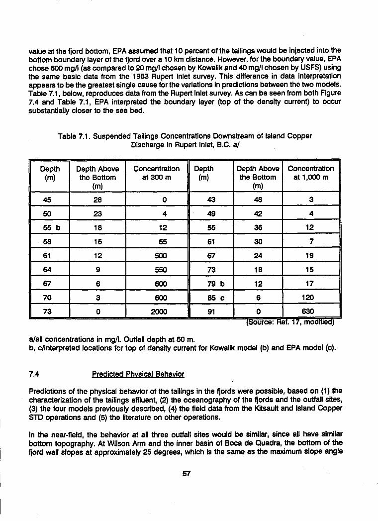
value at the fjord bottom, EPA assumed that 10 percent of the tailings would be injected into thebottom boundary layer of the fjord over a 10 km distance. However, for the boundary value, EPAchose 600 mg/I (as compared to 20 mg/I chosen by Kowalik and 40 mg/I chosen by USFS) usingthe same basic data from the 1983 Rupert Inlet survey. This difference in data interpretationappears to be the greatest single cause for the variations in predictions between the two models.Table 7.1, below, reproduces data from the Rupert Inlet survey. As can be seen from both Figure7.4 and Table 7.1, EPA interpreted the boundary layer (top of the density current) to occursubstantially closer to the sea bed.
Table 7.1. Suspended Tailings Concentrations Downstream of Island CopperDischarge In Rupert Inlet, B.C. a/
Depth Depth Above Concentration Depth Depth Above Concentration(m) the Bottom at 300 m (m) the Bottom at 1,000 m
(m) (m)
45 28 0 43 48 3
50 23 4 49 42 4
55 b 18 12 55 36 12
58 15 55 61 30 7
61 12 500 67 24 19
64 9 550 73 18 15
67 6 600 79 b 12 17
70 3 600 85 c 6 120
73 0 2000 91 0 630(Source: Ref. 17, modified)
a/all concentrations in mg/1. Outfall depth at 50 m.b, c/interpreted locations for top of density current for Kowalik model (b) and EPA model (c).
7.4 Predicted Physical Behavior
Predictions of the physical behavior of the tailings in the fjords were possible, based on (1) thecharacterization of the tailings effluent, (2) the oceanography of the fjords and the outfall sites,(3) the four models previously described, (4) the field data from the Kitsault and Island CopperSTD operations and (5) the literature on other operations.
In the near-field, the behavior at all three outfall sites would be similar, since all have similarbottom topography. At Wilson Arm and the inner basin of Boca de Quadra, the bottom of thefjord wall slopes at approximately 25 degrees, which is the same as the maximum slope angle
57

I
As previously noted, the circulation models predicted that the fines and liquid fraction of theeffluent would remain below the euphotic zone for all these cases. The prediction of the Kowalikmodel was that fines would probably not rise to levels higher than 60 meters. Table 7.2 at theend of this section includes comparison of the physical effects of disposal on the fjords for thethree alternative sites.
7.5 Discussion of Comparative Environmental Impacts
Significant bathymetric changes in the fjord basins, such as would occur with Boca de Quadra Iinner basin discharge and in Wilson Arm/Smeaton Bay, would have some effects on the currentcirculation patterns; and the seasonal deep water renewal cycle in Smeaton Bay would beaffected. However, adverse consequences from these effects were not predictable. Small
58I
I
Itested in the near-field model. Since the exact location of the middle basin site was not specified,the bottom slope there could differ. Other minor differences in behavior could be introduced bylocal current variations, but there is no evidence to suggest any major anomalous influences.
In general, at all three sites the tailings would be expected to descend rapidly in a coherentstream down the fjord wall toward the center of the fjord, slightly downstream of the outfall.Initially there would be some backup toward the estuary, but before long the primary movementof tailings would be down-fjord. A leveed density current would form on the top of the depositedtailings as previously described (illustrated in Figure 7.3) and slumping events would occurperiodically. These events could cause some local turbidity at depth but the models predictedthat no fines would reach the euphotic zone. No split plume would be expected to occur, basedon the near-field model results. Overall, there is no reason to believe that there would be asignificant difference in behavior among the three sites.
Differences in far-field behavior would be governed by bathymetric differences in the fjords andvariations in the current patterns, both described in Section 5. With the tailings disposal outfallat a depth of 150 feet (or 50 m) in the inner basin of Boca de Quadra, the inner basin would fillin about 12 years. The tailings would then flow over the inner sill (345 ft depth) to the middlebasin. At the end of the mine life, the below-sill volume of the inner basin would be 100 percentfilled and the volume of the middle basin would be 15 percent filled.
Tailings disposal at the middle basin outfall site would fill the below-sill volume of the middle •basin to about 20 percent of capacity. The inner basin would be left relatively unchanged, exceptfor the possible limited deposition of fine tailings from tidal currents. In both these cases, themiddle basin would still remain a deep basin after 55 years of tailings deposition. Figure 7.5shows predicted tailings deposition in Boca de Quadra using the inner basin disposal site.
For Wilson Arm tailings disposal, at operational year 55, the deposited tailings would be about245 feet below the surface at the outfall, and from there would gently slope downward to about I150 feet below the top of the sill (near the mouth of Smeaton Bay) at a depth of about 570 feet(see Figure 7.6). After 55 years of mine operations, about 78 percent of the below-sill volumewould be filled with tailings, and the bathymetry of Wilson Arm/Smeaton Bay would besignificantly changed to a shallower fjord. If it were thought desirable to keep the tailings at theoutfall below 100 m depth (328 ft), the outfall could be moved downfjord in the later operatingyears, leaving still sufficient capacity for the tailings below the top of the sill.

1I I I I I -1
i Outfall locaton
(a) 10 Years
-8 -4 0 4 8 12 16
Distance, Klometers
20 24 28
I I I I -J
(b) 25 Years
-8 4 0 4 8 12 16 20 24 28
Distance, Kilometers
I I I I I
Outfall locallon
nner SII
(c) 55 Years
-8 -4 0 4 8 12 16 20
Distance, Kilometers
Figure 7.5 - Predicted tailings deposition indischarge in Inner Basin.
24 28
Modiied from Ryan, 1985
Boca de Quadra -
100
150
200
250
300
350
400
or
E
i
100
150
200
250
300
350
400
0E
0.
50
100
150
200
250
300
350
400
or50
. nitall neionn ' ' 1
n *I I I I I

(b) Year 25
0 1 2 3 4 5 6 7 8 9 10 11 1 113 14 15 1 17 18#dnoL #onma
s50 I . I a 1 1 1 Ii - I I I I I I I
75
100
125
150175
225
250
275
300
II
(c) Year 55
0 1 2 3 4 5 6 7 8 9 10 11 12 13 14 15 16 17 18DOW-o, klonm
Modified from Envirosphere Co., 1985
Figure 7.6 - Predicted tailings deposition in Wilson Arm/Smeaton Bay.
o r75
25
275
300
IIIIIII
50
75
100
125
I 150
S175
225
250
300
IIII
_ __ I I _ _I _ · ·
(a) Year 12
IIIII
I
1l8now, dmonti
1

quantities of tailings fines would be transported over the Smeaton Bay sill into Behm Canal, butwithout significant consequences.
The greatest effect from bathymetric changes was expected to be a change in the benthic biotacomposition from a deep water (>200 m) assemblage to a mid-depth to shallow waterassemblage. This was predicted (Ref. 48, p. 117) to have long-term beneficial effects, some timeafter tailings deposition has ceased, by increasing shrimp and crab commercial fishery resources.In the middle basin of Boca de Quadra, bathymetric changes would not be sufficient to causeany significant effects.
Turbidity increases were generally expected to be confined to the deeper portions of the watercolumn except for possible short-term occurrences. EPA's BPJ analysis stated "Modellingsuggests concentrations of 5-20 mg/i at depths of 50 m (160 ft) during summer (strongeststratification), and no detectable solids in the euphotic zone" (Ref. 49). The circulation modelpredicted that tailings would remain below the pycnocline, but the FEIS (Ref. 41) noted that whilethe circulation model is "the best tool available for predicting impacts to the fjord..., the modeldoes not have the spatial resolution to predict random-type disturbances that could impact thesurface waters. Surface water impacts would be limited to short-term events and to small areasin the vicinity of the fjord sills." Because of the limited nature of these events, their impacts wereconsidered insignificant. Turbidity in the upper mesopelagic zone, however, could reduce therearing areas of juvenile herring by a small percentage. Juvenile salmon would not be affectedin either fjord.
Acute toxicity impacts for discharged tailings were expected to be low, according to EPA's BPJanalysis (Ref. 50). The most likely effects would be physical in nature. Long-term effects onzooplankton, an indicator species for toxicity combined with physical effects, were shown atKitsault to occur only at suspended solids concentrations of 560 mg/I or more; this was expectedto occur at Quartz Hill only within 20 m of bottom (Fig. 7.4, Table 7.1). The likelihood of anyeffects on human health was considered low (Ref. 51).
In areas of active deposition, a rain of tailings would smother those benthic organisms unableto avoid the discharge. In Wilson Arm/Smeaton Bay, an estimated 4100 acres of benthic habitatwould be affected at various times during deposition, while in Boca de Quadra, thecorresponding numbers are 1100 acres for the inner basin and 4000 acres for the middle basin.Discharge to the inner basin thus would affect 5100 acres. However, only 10 percent of theseareas were predicted to be active at any given time. No information was available on theexpected rate of meander or shifting of the path of active deposition.
Recolonization has been shown to occur rapidly in areas not subject to active deposition. Studiesat Kitsault (Refs. 4 and 52) showed significant increases in biomass and species diversity withinone year. Writings by Dr. Derek Ellis of the University of Victoria (Ref. 7) have also describedrecolonization rates to be rapid. Experiments on Quartz Hill tailings by VTN in 1983 (Ref. 58)showed recolonization by many species after one year. VTN estimated complete recolonizationtime for the benthic community under Quartz Hill conditions to be 6 to 25 months. Thus, althoughthe time required for complete recolonization could not be accurately predicted, the effects ofSTD on the benthos (at comparable depths) were expected to be only temporary.
61

I
IOverall, the impacts of discharge on the marine environment would be least on Boca de Quadra'smiddle basin, because of its size and distance from the ocean. Because of the depth of themiddle basin, significant deposition and slumping events would not occur above the pycnocline,which, in EPA's view, made it less likely that fines would be subject to vertical mixing in the upperwater column. With middle basin discharge, bathymetry would be least affected and fewerorganisms would be exposed to the highest concentrations of tailings. The middle basin wouldalso be the only one of the three alternative sites where post-discharge benthic recolonizationwould approximate the pre-discharge assemblages; however, the importance of this is debatable.In Wilson Arm/Smeaton Bay, deposition of tailings would cause significant shallowing from amaximum depth of about 980 ft to a maximum depth after deposition of about 570 ft at the sill.Discharge to Boca's inner basin would cause the greatest marine impacts.The impacts of constructing mixing tanks and outfalls at all three locations would be similar, butat Boca de Quadra, a second drainage basin would be impacted and additional servicing gfacilities occupying up to 25 acres would be required. For middle basin discharge, this land Idisturbance would occur within the Wilderness area. The Wilson Arm site has the advantage ofrestricting impacts of the project to a much smaller area. I
There are significant differences in the impacts of the on-land delivery system among the threesites. For Wilson Arm, the total length of the surface pipeline delivery system is about 14,000 feet. gFor the Boca sites, tunnels of 28,000 to at least 38,000 ft would be required. The additional costs Iof middle basin disposal, estimated in 1984 dollars to be equivalent to 55 cents per pound ofmolybdenum produced, could have an -adverse socioeconomic effect on the Ketchikan area by gmaking employment less stable. Safety risks associated with tunnel construction, considered a Irelatively hazardous industrial occupation, could also be considered a social impact.
Table 7.2, taken from the FEIS (Ref. 40) gives a summarized comparison of the impacts of STD 5for the three alternatives. An error in the reduction of below-sill fjord volume has been corrected.Of interest are the estimates of annualized losses of commercial fishing harvests. These wereestimated in the FEIS (Ref. 41) to have a value totalling less then $8,000 per year. The estimatesrepresent value of lost biomass of commercial species immediately after cessation of dischargeat the end of the mine life, before the onset of any recovery period.
Further discussion of the relative impacts of STD at the three sites can be found in the Final EIS(Ref. 30) on pages 2-36 et seq. and in Appendix S.
8.0 PERMITTING FOR SUBMARINE TAILINGS DISPOSAL
Following is a review of the permitting process for the submarine tailings disposal componentof the overall mine development plan. Emphasis herein is on permitting the tailings slurry outfall Iand the disposal site, which is the floor of the fjord.
8.1 Permitting Summary and Chronology I
Following the location of mining claims in the fall of 1974, the early work at Quartz Hill was gpermitted annually under Environmental Assessments (EA), Decision Notices, and Findings ofNo Significant Impacts made by the Forest Service, followed by Forest Service approval of U.S.Borax's Plan of Operations. This included the initial baseline data gathering work for the NPDES
I
permit application for STD.
62

II
I
ANILCA, passed on December 2, 1980, directed the Secretary of Agriculture to prepare a MineDevelopment Concept Analysis Document (MDCAD) by September 2, 1981 and to complete aDraft Environmental Impact Statement (DEIS) covering road access and bulk sampling within thefollowing two months.
Table 7.2 a/. Comparison of Impacts of Tailings Disposal in the Three BasinAlternatives with a Tunnel Creek Mill
Disposal Basin Alternative
Impact Wilson Arm / Inner Basin Direct toSmeaton Bay Boca de Quadra Boca de Quadra
Middle Basin
Would change Yes Yes Nocirculation of thedischarge basin
Tailings would No No Noimpact salmon
Reduction in below- 78% 100% 46% 20% bsill fjord volume
Resulting fjord 75 to 100 m 80 to 100 m More than 140 mdepths over about 30% over about 100% over about 98%
of basin of basin of basin
Change in resulting To community of To community of Noecological shallower depth shallower depthcommunity structure
Annualized loss of 960 kg 1,630 kg 660 kgDungeness crab
Annualized loss of 480 kg 740 kg 250 kgpot shrimp
Annualized loss of 4,570 kg 7,070 kg 2,790 kgdemersal fish
Suspended tailings Possibly at sills Possibly at sills Possibly at sillsmay reach near-surface waters
a/ Ref. 30, p. 2-37.b/ Error in Ref. 30 corrected.
63

II
In permitting the overall mine development, U.S. Borax submitted to the Forest Service anapplication for "Initial Plan of Operations" in November 1982. The permitting chronology ishighlighted in Table 8.1, and described in more detail in Appendix D. Figure 8.1 illustrates thenumber of phases and the long permitting process from 1976 to 1990. I
8.2 Environmental Concerns and the EIS Process
The environmental areas affected by this planned mine development generally were water and Iair quality, terrestrial and marine biology, wildlife, socioeconomics, and Wilderness values for onetailings disposal outfall site at Boca de Quadra. Those environmental issues considered to be Isignificant for the submarine tailings disposal portion of the project are tabulated in Appendix E I(Ref. 30, Appendix B).
8.3 Forest Service EIS and Permitting Process
Except for the mining claims patented in the mid-1980s, the planned mine development wasprimarily on lands managed by the Forest Service.U.S. Borax's Plan of Operations applicationfor mine development was submitted November 3, 1982 to the Forest Service. In its review of thisapplication, the Forest Service determined that approval would be a significant Federal action;thus, an Environmental Impact Statement (EIS) would be required under the Council ofEnvironmental Quality (CEQ) regulations. The Forest Service would be the lead agency, with EPAand the Corps of Engineers as cooperating agencies. This EIS would provide the environmentaldocumentation and basis for subsequent permits issued by all three agencies.
Pursuant to a Memorandum of Understanding (MOU) signed with the Forest Service, U.S. Boraxcontracted with the Envirosphere Company in January 1983 to prepare the mine developmentEIS under Forest Service direction. Envirosphere spent six years in preparing the EIS and itsvarious drafts and revisions. The Final EIS was issued October 1988, with U.S. Borax paying allof Envirosphere's costs. 3The Forest Service formed an Interdisciplinary Team (IDT) consisting of concerned Federal andState agencies, and including representatives of the Ketchikan Gateway Borough and SouthernSoutheast Regional Aquaculture Association. The Forest Service invited government groups, Iassociations and individuals to a Public Scoping Meeting held on January 19, 1983, with writtencomments to be submitted by February 23, 1983. With this public input and the IDT, the"significant issues" were defined as the basis for preparing the EIS for mine development. Withrespect to STD, nearly all issues raised were considered to be "significant issues" (See AppendixE). IUpon completion of the Final EIS, the designated responsible Forest Service official (in this casethe Regional Forester) issued on October 24, 1988 a Record of Decision (ROD) defining thePreferred Alternative for mine development. Normally, the Forest Service would then issue |permits. However,in this case the ROD was appealed by the Sierra Club et al., which appeal wasstill pending in early 1993. See Appendix C for Forest Service permitting flow diagram.
64

Table 8.1. Quartz Hill Mine Development Permitting Chronology
January 1977
November 1977
December 1978
December 1980
May 1981
December 1981
April 1982
July 1982
November 1982
February 1983
July 1984
April 1987
October 1988
November 1988
September 1990
Draft EIS for Keta River access road and bulk sampling. Final EIS issued July1977.
Special Use Permit (SUP) issued to construct Keta River access road andbulk sampling.
SUP for Keta River access road and bulk sampling cancelled.
Passage of Alaska National Interest Lands Conservation Act (ANILCA).
Draft Mining Development Concept Analysis Document (MDCAD). FinalMDCAD issued September 1981.
Draft EIS for access road and bulk sampling.
Supplemental EIS for access road and bulk sampling, with Blossom Riverroute being the preferred alternative.
Final EIS and Record of Decision (ROD) for Blossom River access road andbulk sampling. SUP issued August 1982. Road construction started August31.
U.S. Borax filed Initial Plan of Operations for overall mine development.
Draft EIS on U.S. Borax's 1980-83 Operating Plan, Amendments 2, 3 & 4.Final EIS issued April 1983.
Draft EIS for mine development with submarine tailings disposal in middlebasin, Boca de Quadra.
Revised Draft EIS for mine development with submarine tailings disposal inWilson Arm/Smeaton Bay.
Final EIS and Record of Decision (ROD) with environmentally preferredtailings disposal alternative in Wilson Arm/Smeaton Bay.
EPA issued draft NPDES permit for tailings disposal in Wilson Arm/SmeatonBay.
EPA denied NPDES permit for tailings disposal in Wilson Arm/Smeaton Bay.
65

I
Year 76 77 78 79 80 81 82 83 84 85 86 87 88 89 90Access Road & Bulk Sampling
Environmental ReportDraft EISFinal EISPermit Canceled
Mine Development Concept
U.S. Borax ConceptDraft MDCADFinal MDCAD
Access Road & Bulk Sampling
Draft EISSuplemental EISFinal EIS
Underground Excavation &Sampling(1980-83 Operating Plan)
Plan of OperationsDraft EISFinal EIS
Mine DevelopmentU.S. Borax Plan of OperationsDraft EISRevised Draft EISFinal EISRecord of DecisionEPA Draft NPDES PermitEPA Deny NPDES Permit
Figure 8.1 - Quartz Hill project permitting schedule.
- n m - - m - m m m m m - u m m m

8.4 Public Participation
A required part of the EIS and the permitting process for development of new mining projects ispublic participation. The Federal and State environmental and permitting regulations generallyprovide for public notice, public meetings (if sufficient interest is shown), and public writtencomments. The responsible agency must respond to these comments prior to finalizing an EISand issuing permits. Various interest groups, some of which appear to be opposed to mineraldevelopment, can appeal the permit decision administratively, if not satisfied with the permittingagency's response to their concerns. If dissatisfied with the appeal decision, they can then litigatein the courts, and appeal to a higher court if not satisfied with the lower court's decision. Thisappeal process can delay projects an undefinable time and adds costs and a significantadditional risk to existing technical, market, economic and overall business risks. These additionalcosts ultimately have to be paid for by the consumers.
The public in Southeast Alaska, and to a lesser degree nationally, showed a keen interest in thedevelopment of the Quartz Hill Project, located in the scenic Misty Fjords National Monument withthe project area surrounded by designated Wilderness. Two principal views were in conflict, onebeing industrial diversification and jobs, and the other the avoidance of any action which wouldaffect the existing environment. There was very active public and other agency participation inthe Forest Service's scoping of the EIS, with many comments on the MDCAD and the variousEIS's. The public, Federal and State agencies also commented extensively on EPA's evaluationsand permits, such as the ODCE, BPJ, draft monitoring plan and permit drafts; Corps of Engineersvarious public notices, and various State permits.
There were concerns in the greater Ketchikan area of the socioeconomic impact of this projecton the community. Options considered for housing the work force and their families included anew townsite near Quartz Hill, or new housing in Ketchikan with workers commuting periodicallyto the site. Ultimately, housing of the work force in Ketchikan was selected as the preferredalternative. Besides housing, the community concerns included employment, community servicesand taxes/revenues. U.S. Borax held extended discussions with representatives of the City ofKetchikan, City of Saxman and the Ketchikan Gateway Borough on the potential project impactsand how to mitigate them. A Memorandum of Understanding was signed between the KetchikanCommunities and U.S. Borax on procedures for discussing and resolving potentialsocioeconomic impacts and became part of the Final EIS (Ref. 30, pp. 1-56 to 1-65).
The Company endeavored to keep the public and agencies informed through public meetings,issuance of fact sheets, and tours of the project site. The concerns of the public were consideredin defining the various development options and in selecting the preferred alternatives.
8.5 EPA Permit Application
In Alaska, EPA retains the responsibilities for the Clean Water Act regulations. Thus, alldischarges to water bodies require EPA's National Pollutant Discharge Elimination Systempermits (NPDES).
Because EPA on December 3, 1982 ruled that the NSPS should not apply to discharges from theQuartz Hill Molybdenum Project (47 FR 54609), the NPDES permit conditions would be
67

I
Ideveloped through the environmental/permit review process using the EIS (prepared by USFS,with EPA as a "cooperating agency") as the basis (see Section 3.2.2).
U.S. Borax in July 1983 filed a NPDES permit application for five effluent outfalls, one of whichwas an inner basin, Boca de Quadra tailings disposal outfall. Five months later, the Companysubmitted to EPA its report entitled "Comparative Assessment of Tailings Disposal Alternatives"in support of its NPDES permit application (see Section 3.3). Using this information, EPA made Ua detailed analysis of on-land versus submarine tailings disposal, and determined submarinetailings disposal to be the preferred alternative, subject to an environmental analysis. The initialEPA evaluation of this permit application was based on Ocean Discharge Criteria (40 CFR Part125, Subpart M) for an environmental evaluation of estuarine and marine impacts. EPA acted asa cooperating agency with the Forest Service in the preparation of the Draft EIS issued July 17,1984. EPA issued a draft Ocean Discharge Criteria Evaluation (ODCE) in June 1984, whichformed part of the Draft EIS (Ref. 50). A draft NPDES permit was issued in August of that yearfor a tailings outfall in the middle basin of Boca de Quadra, 2.1 miles down-fjord of the Inner sill,in the Wilderness. This draft ODCE did not include Wilson Arm as a possible alternative tailingsdischarge site. W
Meanwhile, U.S. Borax had developed more information on Wilson Arm/Smeaton Bay, whichindicated that previous concerns about the adequacy of this fjord could be satisfactorily Iaddressed. In January 1985, the Company submitted a revised NPDES permit application fortailings disposal in Wilson Arm/Smeaton Bay. A draft monitoring plan was also submitted by theCompany to EPA at that time.
In May 1986, the United States Department of State confirmed that Smeaton Bay and Boca deQuadra were "internal waters" under jurisdiction of the State of Alaska (see Section 3.2.3), which Idid not require application of ODC regulations. EPA subsequently decided to use the ODCE asthe Best Professional Judgment (BPJ) to evaluate the environmental impacts. EPA issued a BPJ gin November 1986. In March 1988, EPA issued a draft report "Ecological Risk Assessment of |Submarine Tailings Disposal in Boca de Quadra versus Wilson Arm/Smeaton Bay" (Ref. 53). Afinal BPJ for tailings disposal was submitted June 1988, and became Appendix S of the Final EIS,issued by the Forest Service in October 1988 (Ref. 30, Appendix S).
Subsequent events are covered in succeeding sections. In Appendix C is a flow diagram for theprocessing of EPA's NPDES permit.
8.6 Corps of Engineers Permit Application
The Corps of Engineers has jurisdiction over construction or work in or affecting navigable watersunder Section 10 of the Rivers and Harbors Act of 1899; and regulates discharge of dredged orfill material in waters of the United States, including wetlands, under Section 404 of the CleanWater Act of 1977.
U.S. Borax submitted to the Corps in July of 1983 a pre-application for a permit to cover thoseproject phases primarily related to submarine tailings disposal, which included the constructionof tailings outfall facilities and deposition of "fill material" (tailings) into navigable waters of theU.S. The Corps first issued a Public Notice July 20, 1984. As changes were made by theCompany to the plan for project development, the application was amended. Revised Public I
68
I

Notices were issued by the Corps of Engineers in August 1984, May 1987, June 1987 and inOctober 1988; the last of which was included in the Final EIS (Ref. 30, Appendices O and P). TheCorps of Engineers received comments on the Public Notices from other agencies and thepublic, and the Company assisted in answering them.
8.7 State of Alaska Permit Applications
The State of Alaska regulations directly or indirectly applicable to Quartz Hill STD permitting areprimarily concerned with State water quality standards, water rights, anadromous fish protection,solid waste disposal, Coastal Zone management; and tidelands and submerged lands rights. Thesignificant permitting by the various State agencies is outlined below.
8.7.1 Office of the Governor, Division of Governmental Coordination
U.S. Borax submitted permit applications directly to the various responsible State agencies, butalso submitted copies of these and the Federal permits applications as a Master Application tothe Division of Governmental Coordination (DGC). DGC coordinated the review of all theseapplications by the various interested State agencies. After this review, each responsible agencycould then issue its respective permits.
A flow diagram of this process is shown in Appendix C. As shown on this diagram, initially theMaster Application was submitted in April 1983 to the Department of EnvironmentalConservation, but subsequently this procedure was modified. Updated information was submittedto DGC in 1988.
The Office of the Governor has responsibilities for the Alaska Coastal Management ProgramCertificate of Consistency for the project. In June 1983, U.S. Borax filed a request for CoastalManagement Program Certification. After issuance of the Final EIS and the Regional Forester'sRecord of Decision in October 1988, the DGC initiated a project consistency review in February1989. This consistency review was suspended late the same month, awaiting information fromEPA on a monitoring program for tailings disposal in Wilson Arm/Smeaton Bay. Upon DGC'sreceipt of a draft monitoring plan and other data from EPA, and additional data from theCompany, the consistency review was reinitiated in January 1990; and again suspended later thatmonth, pending receipt from EPA of a revised draft monitoring plan. Since EPA never releasedthe plan, this review process was not completed.
8.7.2 Alaska Department of Environmental Conservation
A Certificate of Reasonable Assurance is required for those Federal permits involving activitieswhich result in discharge into navigable waters or which may affect water quality. This certificationis required to comply with Section 401 of the Clean Water Act. EPA's NPDES and Corps ofEngineers Section 404 permits require this certification. A flow diagram for processing thiscertification is shown in Appendix C.
Alaska Department of Environmental Conservation (ADEC) participated with DGC, along withother State agencies, in the review of the Master Application for Coastal Management ProgramCertificate of Consistency. This included ADEC's review of the Quartz Hill Project for Certificateof Reasonable Assurance requirements (see above DGC permitting section). The certification by
69

ADEC is the State's way of ensuring project compliance with State Water Quality Standards. U.S.Borax submitted a tailings disposal contingency plan in 1989 addressing what actions could betaken if tailings disposal did not behave as forecast and permitted. ADEC's certification processfor the project was never completed because of EPA's failure to release a draft monitoring planfor Wilson Arm/Smeaton Bay.
8.7.3 Alaska Department of Natural Resources
The ore milling process would use significant quantities of fresh water, which would ultimatelybe discharged with the tailings slurry to the floor of the fjord. The permits required of the AlaskaDepartment of Natural Resources (ADNR) are water rights for water supply, tidelands leases fortailings disposal pipelines and outfall facilities, and submerged lands leases for the area of thefjord floor where the tailings would be deposited.
Applications for the above permits were submitted during the 1980's and supplementalinformation was provided as mine development plans were revised. ADNR issued a public noticeon the water permit applications and received no significant public comments. ADNR alsoparticipated in the Master Application review process. In early 1990, ADNR was proceedingtoward issuance of permits but required DGC's certification of the Coastal Management Program Iand ADEC's issuance of a Certificate of Reasonable Assurance before permits could be issued.
8.7.4 Alaska Department of Fish and Game
The Habitat Division of the Alaska Department of Fish and Game (ADF&G) administers AlaskaStatutes 16.05.840 (Fishway Act) and 16.05.870 (Anadromous Fish Act). These statutes requirepermits if there are any project-related activities in an anadromous waterbody. For the Quartz HillProject, such permits would be required for the water supply facilities, roads, wharf andpipelines/outfall for the tailings disposal system. These Title 16 permits were considered to bea lower priority by U.S. Borax, scheduled to be applied for when a commitment to construct wasmade.
8.8 Summary of Agency Coordination
Since the Forest Service manages most of the lands required for project development, it was thelead agency for the Federal EIS and permitting processes. EPA and the Corps of Engineers werethe other two Federal agencies with permitting authority. U.S. Fish and Wildlife and NationalMarine Fisheries Service had a statutory and significant review function.
The principal State of Alaska permitting agencies were DGC, ADEC and ADNR; with ADF&G Uhaving primarily a review responsibility. As indicated above, significant coordination was required.For the State, this was the responsibility of DGC, which formulated the State position based oninput from the other State agencies.
The principal formal coordinating mechanism used by the Forest Service for all concerned partieswas the Interdisciplinary Team (IDT). This was formed by the Forest Service and composed ofall interested Federal and State agencies, representatives of the community, the regionalaquaculture association and the Company, to scope the EIS and advise on its preparation. 3
70
I

U'
1I
71
DGC and ADEC's certifications of Coastal Management Program and meeting Alaska WaterQuality Standards (Certificate of Reasonable Assurance) are required prior to the Corps ofEngineers and EPA issuing their respective permits. Thus, a close working relationship wasnecessary between all State and Federal agencies, the community and the permit applicant, inorder to permit mine development in a timely and cost effective manner.
8.9 Mitigation. Monitoring and Reclamation
In the processes of project engineering, preparing the EIS and permitting; evaluation ofalternative mine development plans resulted in definition of the preferred alternative for projectdevelopment. This alternative included in its design many mitigations of environmental impacts.The construction and operational plans when formulated would also include mitigation measures.These are discussed at length in the Final EIS (Ref. 30, pp. 4-280 to 4-310).
The objective of the environmental baseline data collection program was to characterize theenvironment sufficiently for selection of the preferred mine development alternative. After definingthe plan for mine development, monitoring programs could be scoped. Monitoring for impactswould be initiated just prior to construction, and continued during construction, operations andpost operations. The Forest Service formed a committee of various agencies to scope a fisheriesmonitoring program. U.S. Borax submitted to EPA a separate monitoring program for submarinetailings disposal. EPA's draft revision of this plan for Wilson Arm/Smeaton Bay was to be issuedfor U.S. Borax and public comment. This monitoring program when finalized would have beenpart of the NPDES permit. Monitoring was discussed further in the Final EIS (Ref. 30, pp. 4-310to 4-313).
The Final EIS discussed reclamation and post-mining reclamation. The Forest Service wouldinclude reclamation requirements, along with monitoring and mitigation, as terms and conditionsof the future approved Plan of Operations. The permitting process had not progressed to thepoint where these plans were finalized. The Forest Service would require a reclamation bondbased upon the costs associated with requirements of an approved reclamation plan.Reclamation was discussed in the Final EIS (Ref. 30, p. 2-8).
9.0 THE FINAL EIS AND VARYING INTERPRETATIONS
9.1 The Forest Service's Record of Decision
The Final EIS for the Quartz Hill project was published on October 21, 1988 by the U.S.Department of Agriculture, Forest Service, with the Forest Service acting as lead agency and theEPA and Corps of Engineers acting as cooperating agencies. Both of the latter were involved orconsulted in the FEIS preparation. The intention was that all three agencies would use the FinalEIS as the basis for their subsequent permitting procedures.
The Record of Decision (ROD), issued separately on October 24, 1992 and written in consultationwith the EPA and the Corps of Engineers, selected tailings disposal in Wilson Arm/Smeaton Bayas part of the "environmentally preferred" alternative. The ROD stated (Ref. 42):
The environmentally preferred alternative for tailings disposal is marine disposal in WilsonArm/Smeaton Bay. Impacts of the discharge will be evaluated through a monitoring program
developed by EPA in conjunction with issuance of a National Pollution DischargeElimination System (NPDES) permit for the tailings disposal. The monitoring is primarilyintended to ensure that unreasonable or unanticipated degradation to the aquaticenvironment is not occurring. The NPDES permit will be designed to avoid exceeding waterquality criteria outside the mixing zone for the discharge. Depending on the results of themonitoring program, the permit for tailings disposal may be modified or even terminated,if necessary, prior to the completion of the design life of the project.
There is a slightly higher risk of adverse consequences to the environment with tailingsdisposal in the Wilson-Smeaton basin than in the Boca de Quadra basin because the 1overall capacity to receive the tailings is less. Studies demonstrate, however, there is ample Icapacity, so the difference in risk is not significant. Coupling this with consideration of theimpacts on Misty Fjords Wilderness from disposing of tailings in Boca de Quadra, the goverall environmentally preferred alternative is disposal in Wilson/Smeaton Basin. Therefore, Ithe preferred alternative is the environmentally preferred alternative.
The ROD went on to explain, as rationale for the selection: IThere is little difference in the environmental effects of tailings disposal in the marineenvironment between the Wilson Arm and Boca de Quadra fjords. The effect of disposal onanadromous fish, other food fish, and fish habitat is similar in both fjords.
The Wilson Arm alternative offers added advantages. First, the impacts of the minedevelopment are confined to a single, smaller drainage. Second, it reduces the impacts onwilderness values since it is not necessary to construct facilities for tailings disposal in theMisty Fjord National Monument Wilderness as would be required if disposal were in the IBoca de Quadra. Third, based on historic and projected molybdenum markets, disposal inthe Wilson Arm would result in greater community stability for Ketchikan and southeastAlaska. The frequency of mine shutdown will be less and the duration of shutdown would 3be shorter as a result of the difference in operating costs.
In detailing his decision in the ROD, the Regional Forester for Southeast Alaska stated that hewould authorize approval of the U.S. Borax operating plan as described in the Final EIS, subject Ito further mitigation measures. With respect to tailings disposal, these were outlined as follows:
Mine tailings disposal will be allowed in the submarine environment of Wilson Arm/ SmeatonBay in accordance with the provisions of the NPDES permit to be issued by the EnvironmentalProtection Agency. A comprehensive monitoring program will be required to provide earlysignals of tailing behavior so that comparisons to the predictive modeling can be made.Should it be discovered that tailings fill at a faster rate, behave in a detrimental manner, orcause unpredicted resource damage, changes will be needed. The changes could run thespectrum of reducing mine life to altering the tailings disposal site depending on the type andmagnitude of variance from the predictive models.
Regarding the issuance of permits by the cooperating agencies based on the Final EIS, Section IVIII of the ROD, "Determinations," stated that:
I72 I

III
73
The EPA will issue a draft National Pollution Discharge Elimination System (NPDES) permit fortailings disposal in Wilson Arm/Smeaton Bay for public review and comment in the immediatefuture. Following the review period the EPA will issue a final permit. The purpose of the NPDESpermit is to ensure compliance with section 402 of the Clean Water Act. The permit will bedesigned to prevent unreasonable degradation of the marine environment. Section 403 (c)guidelines have been used to evaluate the proposed discharge and are documented inAppendix S of the FEIS.
The ROD also stated that the Corps of Engineers would be issuing its permits for the project,under the Rivers and Harbors Act and under Section 404 of the Clean Water Act.
9.2 The Environmental Protection Agency's Position
EPA's environmental assessments in May and June 1988 (the BPJ Analysis and Risk Assessmentdocuments respectively, Refs. 48 and 53) had expressed a preference for tailings disposaldirectly into the middle basin of Boca de Quadra; the concept of STD over land disposal havinglong since been accepted. This preference was based on the evaluation of comparative risks tothe marine environment only. On some other non-related rulings, however, EPA had in the pasttaken the position that broader considerations such as socioeconomics should also play a rolein a permit decision. In remarks given at the American Mining Congress convention in SanFrancisco in September 1985, Milton Russell, EPA's Assistant Administrator in Washington incharge of policy, planning and evaluation stated, "the implications of (EPA's) actions on theproduction of goods and services and on standards of living must be given due weight" (Ref. 19).
In making the ruling that EPA concurred with the Forest Service's ROD, Robie Russell, RegionX Administrator, recognized the need to balance the various environmental and socioeconomicfactors relating to project impacts (Ref. 56, p. 5). In spite of the environmental reservations ofRegion X staff, his decision was confirmed in a letter dated December 6, 1988 by the Director ofthe Water Division of Region X to the Forest Service's Forest Supervisor in Ketchikan (Ref. 54).That letter stated: "The Preferred Alternative as described in the FEIS is acceptable to EPA....Ourposition is that the projected risk does not preclude tailings disposal in either fjord, provided thatappropriate environmental monitoring is conducted." The Water Division Director's letter alsostated that Boca de Quadra remained EPA's primary choice for STD for environmental reasons.However, in a notice published in the Federal Register on December 23, 1988, the statement wasmade "EPA feels this Final EIS is acceptable as described."
Meanwhile, EPA's Region X staff prepared a draft NPDES permit for Wilson Arm/Smeaton Bay,which was issued in November 1988. This included a draft of monitoring requirements, to whichU.S. Borax responded with comments. Throughout 1989, EPA Region X staff continued to workon the Wilson Arm/Smeaton Bay permit application but delayed issuance of the permit, partlybecause of a Clean Air Act provision (Section 176(c)) which required State approval of EPA'sproposed State Implementation Plan (SIP) before other permits could be issued. As late asDecember 28, 1989, Robie Russell, EPA's Region X Administrator, Indicated in a letter to U.S.Borax (Ref. 55) that the Wilson Arm/Smeaton Bay NPDES permit would be issued as soon as theSIP had been approved, and U.S. Borax had amended its air permit application to comply withSIP requirements. Other events, however, would soon bring this activity towards approval of theWilson Arm STD site to a halt.

II
Early in 1990, Mr. Russell left the Agency. Subsequent allegations made by employees of RegionX resulted in a Special Review by EPA's Office of the Inspector General of the Region's handling 1of air and water issues. The Inspector General's report, issued on May 3, 1990 (Ref. 56), foundthat the Regional Administrator's decision to approve a draft NPDES permit for the disposal ofmine tailings into Wilson Arm/Smeaton Bay failed "to adequately protect the environment..., was Inot supportable based on available economic or scientific data...(and) was also contrary to theunanimous recommendations of the Water Division management and staff" that Boca de Quadra Iwas the environmentally preferred site. The report also stated that "disposal of mine tailings into Ithe Wilson Arm of Smeaton Bay fjord will turn the fjord into a bay. This has the potential todestroy a valuable salmon resource." 3One day after the issuance of the Inspector General's report, the newly appointed ActingRegional Administrator of Region X, Thomas Dunne, issued a tentative denial of the NPDES •application for STD into Wilson Arm/Smeaton Bay. This met with strong protest from the Forest IService, who had not been consulted. Michael Barton, Regional Forester in Juneau, designatedas the responsible Federal official for the Quartz Hill EIS process, wrote in a letter to Mr. Dunne •on May 8th: "I am astonished by this unexpected action on behalf of EPA. The Forest Service has 3worked closely for over a decade with the Environmental Protection Agency, the State of Alaska,and many other agencies on this project. This was culminated by release of the Record ofDecision and Final Environmental Impact Statement..."(Ref. 43). An early meeting was requested, Ibut no meeting had been held by the first week of July, when Mr. Barton wrote a second letterrequesting that further action on the permit should be suspended until the Chief of the ForestService could rule on a related Sierra Club appeal of the ROD (Ref. 44). IPublic hearings on EPA's proposed permit denial were held in Ketchikan and Juneau, Alaska,in June 1990. These were followed by a public comment period which elicited 120 letters bothfor and against the tentative denial, and a "petition in support of Borax Mine" with approximately420 signatures. On July 5, the Ketchikan City Council passed Resolution 90-1632 urging EPA to"allow U.S. Borax the chance to discharge tailings in Wilson Arm with close monitoring to assure 3the company complies with its promise of operating in an environmentally sound manner and notadversely affect other resources, especially commercial fishing."
9.3 Corps of Engineers I
As one of the three cooperating agencies in the preparation of the EIS, the Corps had animportant role to play in issuing the Section 10 (Rivers and Harbors Act) and Section 404 (Clean IWater Act) permits for the project. However, the Corps did not express publicly any preferenceas to STD site alternative and did not appear to play a part in the NPDES permit denial. I9.4 The State of Alaska
The State agencies and administration had a more direct role. Their permitting functions included Iwater quality, fisheries protection and furthering economic development; in addition to the basicgovernmental function of representing the will of the majority of voters. IThe State agencies most directly concerned with Quartz Hill seemed to hold varying views onthe choice of the preferred STD alternative, roughly compatible with their functions. As theagency overseeing water quality, ADEC was the most concerned with technical evaluations on
74I

I
the effects of the discharge. This agency also had the responsibility for setting the limits of themixing zone (the zone starting at the outfall within which Alaska water quality standards may beexceeded) under guidelines set forth in the Alaska Administrative Code.
One of ADEC's concerns was that the size of the mixing zone needed would violate certainlimiting provisions of the guidelines, which were not written with the requirements of STD in mind.However, the Administrative Code contains language giving ADEC discretionary authority towaive these provisions. ADEC also was concerned about the exceedance of water quality criteriafor suspended sediments above the 100 m level predicted by both circulation models, theexceedance in dissolved copper predicted by the EPA model, and the projected loss of tailingsfines over the Smeaton Bay sill into Behm Canal. ADEC, however, did not necessarily acceptEPA's definition of the 100 m depth as being the level above which water quality standards hadto be met (Ref. 1). U.S. Borax attempted to meet ADEC's concerns by presenting information andproposals at meetings held in September 1989 and June 1990 with ADEC and other Stateagencies (see next section).
ADF&G preferred Boca de Quadra as an STD site because of lesser perceived marine impactsand this agency's role of safeguarding the interests of the fishing industry; however, ADF&Gagreed that salmon would not be affected in either fjord. ADCED favored the Forest Service'sROD selection of Wilson Arm/Smeaton Bay, while ADNR did not publicly express a position.
In July 1990, DGC in its role of coordinating the State's position, wrote to EPA stating that theState could find "no technical basis for objecting to the proposed denial of the current NPDESpermit application." The letter also recommended that EPA should provide opportunities fordiscussion of technical and procedural issues prior to a final decision (Ref. 21).
9.5 The Developer's Position
In the previously mentioned meetings in 1989 and June 1990, U.S. Borax sought also to respondto the conditions made by the State in its 1987 conditional acceptance of Wilson Arm/SmeatonBay (Ref. 22). Pursuant to EPA's request, Borax submitted draft water quality and toxicitymonitoring plans to EPA and a draft contingency plan was discussed and submitted to the State.
The Company had a number of basic disagreements and concerns with EPA's evaluation of theNPDES application for Wilson Arm/Smeaton Bay, many of which had to do with the handling andinterpretation of data. For example, the Company felt that a misinterpretation of the Rescansuspended sediment data from Rupert Inlet led to the selection by EPA of an inappropriateboundary value for suspended sediments used as input to EPA's circulation model. This was 30times higher than that used by the University of Alaska's Kowalik (supported by Bechtel and itsBoard of Consultants), and 15 times higher than that considered reasonable by the ForestService. In the Company's opinion, this led to gross overestimates of the distribution andconcentrations of suspended sediment levels in the fjord. These overestimates, in turn, led tooverestimates of the predicted copper concentrations; because EPA added to the dissolvedcopper values a percentage of the acid extractable portion of the copper in the fines, on thetheory that they would be leached out. Use of EPA's acid extractable protocol for determiningcopper in seawater was in itself a subject of disagreement, and seemed to the Company'sscientists to be inappropriate in view of the slightly basic and buffered waters of the fjord.
75

Another area in which the Company disagreed was EPA's seemingly arbitrary selection of 100m as the depth above which all water quality standards must be met. Based on its interpretations Iof the scientific evidence, the Company felt that minor exceedances of water quality standardsbetween 100 m and 60 m depth could be tolerated without any detectable effect on the marineecology, because the biologically important euphotic zone extends to a maximum depth of only I25 to 30 m.
U.S. Borax therefore proposed that the top of the mixing zone be set at 60 m, with the exception Iof a 300 m radius cylinder extending to surface around the outfall. The westem edge of themixing zone would be at the Department of State closure line drawn across the mouth ofSmeaton Bay. In attempts to resolve some of the other outstanding points of disagreement, the |Company also made some important commitments in letters to EPA in June 1990 (Ref. 24).These included: 3
* Borax would lower the depth of the outfall to 100 m.
* There would be no significant effect from the discharge to the marine biota above the 100 3m level.
* The actual dissolved copper concentration in the discharge would meet the EPA one hour Iaverage criterion (2.9 ug/l) at the end of the discharge pipe.
EPA made no direct response to these commitments prior to the final denial. Nor was there anyreply to requests from the Company for meetings to resolve remaining differences of opinion.Had there been opportunities for discussion as recommended by the State, the Companyplanned to propose mitigation measures to alleviate most of the concems by means of processmodifications and other technical changes.
The Company position in June 1990 was outlined in a position paper and the testimony of itsVice-President and Quartz Hill Project Manager, at the EPA hearings in Ketchikan and Juneauon June 19 and 20 (Ref. 25). In summary, Borax felt that EPA's reversal of its previous tentativedecision was not supported by any new scientific or socioeconomic data and there was no 3explanation of how the same technical evaluations could now be interpreted to yield a totallydifferent conclusion. The Company believed that EPA's perceived problem conceming tailingsdeposition above the 100 m level late in the mine life could be handled by moving the outfalldownfjord prior to operating year 45, or by simply shortening the mine life. EPA was felt to haveadequate environmental control, through required renewals of the NPDES permit every five years.EPA's concern about undue shallowing was not considered valid since the fjord would still be 3between 250 and 570 ft deep, and the change in benthic biota composition would beeconomically beneficial in the long term to the commercial fishery.
Borax felt that the evidence from the extensive investigations over 12 years showed that the risksfrom marine disposal in either fjord would be small and acceptable. In the absence of anysignificant differences between fjords, the Company urged EPA in making its decision to take abroader view of considering all the project impacts, other than simply looking at the marine Iimpacts; and to recognize the other offsetting factors. These were listed as:
I76

* Confining the impacts of the project to a single, smaller drainage basin,
* Avoiding direct Wilderness intrusion from a tunnel portal in the Wilderness,
* Maximizing the socioeconomic benefits to Southeast Alaska by avoiding unnecessaryproject costs which would weaken the project financially,
* Minimizing risk of worker injury by eliminating the need to construct a 71/ mile tunnel toBoca de Quadra,
* Reduction in terrestrial impact area, noise and visibility.
Objective consideration of these offsetting factors, the Company felt, would confirm the ForestService's conclusion that STD in Wilson Arm/Smeaton Bay was the overall environmentallypreferred alternative. More detailed comments were sent to EPA by letter in early July 1990 (Ref.26).
10.0 THE PERMIT DECISION
10.1 EPA's Permit Denial
The denial of U.S. Borax's application on behalf of Pacific Coast Molybdenum Company todispose of Quartz Hill mill tailings into Wilson Arm/Smeaton Bay was affirmed by EPA onSeptember 27,1990. The Final Decision of the Acting Regional Administrator (Ref. 57) stated thatEPA's earlier proposal to permit the discharge was re-evaluated because of "several" publiccomments opposing the proposal. The comments were to the effect that the proposed dischargewould impact the fisheries, benthic organisms and biologically significant upper water column ofSmeaton Bay and violate Alaska water quality standards.
In its re-evaluation, EPA found that in order for water quality criteria to be met, the top of themixing zone would need to extend upward "into the important habitat for marine organismsidentified as the water column above 100 m depth. Allowing a mixing zone to extend into thishabitat would have a significant adverse impact on the beneficial uses of Wilson Arm/SmeatonBay". The permit application was therefore denied on the basis that "The proposed dischargewould significantly impact the existing beneficial use of Wilson Arm/Smeaton Bay and exceed thewater quality standards for sediment and copper." No comment was made on the ultimateacceptability of Boca de Quadra as a STD site.
10.2 Subsequent Developments
The Company had the option at this point of requesting an evidentiary hearing within 30 daysto attempt to have Region X's decision overturned, but chose not to do so for policy reasons andbecause the depressed state of the molybdenum market would not justify further largeexpenditures on the project at that time. Instead, Borax announced in Ketchikan in October 1990that the project was postponed indefinitely.
A year later, the Quartz Hill project was sold by U.S. Borax to Bonna, Incorporated, an affiliateof Cominco, Ltd., an international mining group with headquarters in Vancouver, BC, Canada.
77

IAs of early 1993, the new owners had not announced any resumption of Quartz Hill permitting Iactivities.
By March 1993, the Chief Forester of the Forest Service had not yet ruled on the ROD appealof the Sierra Club Legal Defense Fund et al., which argued many of the same points cited byEPA in its denial of the Wilson Arm/Smeaton Bay NPDES permit application.
11.0 OBSERVATIONS ON THE STD PERMITTING PROCESS
11.1 Discussion of Permitting Issues
A number of issues were addressed during the project developer's attempt to obtain the permitsfor the first regulated STD operation in the United States. Some of these were technical and Iothers procedural in nature. A brief discussion of some of the problems which arose may bebeneficial in reflecting on what lessons can be learned from the Quartz Hill experience. Thediscussion below is intended to illustrate some of the more obvious flaws of the permittingsystem (or state of development of the system) existing during the 1980's.
Many of the technical problems involved differing interpretations of scientific findings and mempirical data. An example previously mentioned is the three different interpretations of data fromthe Rupert Inlet suspended solids survey. The estimates by Bechtel's Board of Consultants andthe University of Alaska, the Forest Service, and EPA for the suspended solids value at the topof the turbidity current spanned a range from 20 mg/I to 600 mg/I, leading to the varyingpredictions of the circulation models. It is arguable that it would have been possible to narrowthe range by means of direct discussion among the scientists involved; however,this was neverdone. To the Company, EPA appeared reluctant to enter into discussions aimed at working out aproblems with the applicant.
The non-standardization of criteria and the lack of parameters set for evaluating the criteria couldbe considered a systemic flaw which resulted from the lack of experience with STD in the UnitedStates. The Company did not agree with EPA that the 100 m depth was the level above whichall marine life must be protected, but did not immediately contest this determination. When EPAapplied this depth to define the top of the mixing zone, the effect was that of mandating that allwater quality standards must be met above the 100 m level. Both circulation models had alreadyindicated that minor exceedances of suspended solids criteria could occur on occasion up toabout the 60 m level. Suspended tailings fines, however, would remain below the euphotic zone Iand generally below the pycnocline. The disagreement centered on the importance of occasionalminor incursions of fines between the 100 and 60 m levels and, therefore, on what level to hold *inviolate for permitting purposes.
The Final EIS, in which EPA participated, had concluded that marine tailings disposal would not naffect migration of anadromous fish and that "all tailings impacts to salmon would be insignificant" I(Ref. 44). However, EPA took the position that any fines incursions above 100 m could affectimportant marine biota. The Company was sufficiently convinced about the insignificance of these gpredicted occasional incursions to issue a commitment in June, 1990 that there would be "no Isignificant effect" from the tailings discharge on the marine biota above the 100 m level, with theexception of the prescribed mixing zone in the immediate area of the outfall (Ref. 24). A related
78 1
I
issue was the lack of an appropriate approved protocol for copper determinations on suspendedsolids in seawater.
Some questions seemed to cause undue concern long after evidence had been presented whichshould have put the matter to rest. One example is the estimated loss of fines over the SmeatonBay sill, which was not regarded in the Final EIS as unacceptable and was considered in 1986by National Marine Fisheries Service to have an undetectable effect on the fishery resources ofBehm Canal (Ref. 12). The opinion of NMFS was not challenged; nevertheless, the point was stillbeing raised in 1990 by some agencies and opponents of the project (Appeal to the Chief of theUnited States Forest Service, Appeal No. 3080, Sierra Club Legal Defense Fund). Anotherexample is the statement of EPA's Inspector General, in April 1990, that STD in WilsonArm/Smeaton Bay would have potential to "destroy a valuable salmon resource", long afterfisheries experts had agreed that salmon resources would not be affected.
Among the procedural problems encountered was the complexity of the existing permittingstructure. This led to time requirements and expense, for both the developer and the permittingagencies, which most observers would consider excessive. Appendix C is illustrative of thiscomplexity. For the Quartz Hill STD permitting, there was direct involvement of three Federalagencies and four State agencies. The time involved spanned over twelve years, from the startof baseline data gathering to the permit denial. During this time U.S. Borax spent over $25 millionon overall project environmental and permitting activities, the majority of which was connectedwith STD permitting. Estimates for agency expenditures are not available, but must run in themillions of dollars. While some of the delays were caused by other factors, the extreme cost andlength of the proceedings alone argue for a simplification of the permitting procedure. Theaddition of provisions to encourage a closer working relationship between the permittingagencies and the applicant would also assist in expediting permit issuance.
A legal problem which delayed EPA's activity on the permit application in 1989 (Ref. 55) was theClean Air Act provision in Section 176(c) that prohibited the issuance of all permits by Federaland State agencies until State approval of EPA's State Implementation Plan (SIP). This causeda serious setback to the project schedule for reasons totally unrelated to the merits of the STDapplication and beyond the control of either the applicant or the agency personnel dealing withthe application.
11.2 Conclusions
The extensive studies at Quartz Hill have suggested that under certain conditions, the choice ofthe submarine tailings disposal alternative for a mining project can result in the least impact tothe overall environment among the "action" scenarios. The closely monitored experience at IslandCopper has shown that STD can be designed and practiced effectively without unacceptableeffects on the marine ecology. What remains is a rationalization of the regulatory system whichwould allow STD to be permitted efficiently, while at the same time ensuring that the project willoperate with no unacceptable degradation and irreparable harm to the environment. The QuartzHill experience has indicated that a more effective permitting structure could be attained underthe aegis of one agency, which would focus on all of the impacts of the project, includingsocioeconomic, to arrive at a decision in the public interest, while preserving the traditional rightsof responsible and timely development inherent in a free enterprise system.
79

REFERENCES
1. Alaska Department of Environmental Conservation. Memo from D.D. Kelso, Commissioner, toDenby Uoyd, Office of the Governor; June 11, 1990.
2. Alaska National Interest Lands Conservation Act (ANILCA), Public Law 96-487, Dec. 2, 1980.
3. Alaska National Interest Lands, Report No. 96-413, Report of the Committee on Energy andNatural Resources, United States Senate, to accompany H.R.39, Nov. 14, 1979.
4. Burling, R.W., J.E. Mclnerney and W.K. Oldham.A Technical Assessment of the AMAX/KitsaultMolybdenum Mine Tailings Discharge to Alice Arm, British Columbia. Ministry of Fisheries andOceans, Government of Canada, 1981.
5. Burrell, D.C. The Biochemistry of Boca de Quadra and Smeaton Bay, Southeast Alaska, ASummary Report of Investigation, 1980-82. Institute of Marine Science, University of Alaska,1983.
6. Cowper, Steve.Governor of Alaska, letter to Dorothy Jones, Chairman, Citizens AdvisoryCommission on Federal Areas, Aug. 17, 1987.
7. Ellis, D.V.Professor of Biology, University of Victoria, British Columbia, letter (with attachments)to EPA Region X, Seattle; June 18, 1990.
8. Findikakis, A.N., P.J. Ryan and J.F. Kerl.Design and Installation of Concentration andDewatering Circuits, Chapter 11, A Study of Marine Disposal of Mine Tailings. Hartzog, LD.(ed.) Society of Mining Engineers, Colorado, 1986, pp. 171-179.
9. Kowalik, Z., and A.N. Findikakis. The Physical Oceanography of Wilson Arm/Smeaton Bay: TheNumerical Modeling of Fjord Circulation and Submarine Disposal of Mine Tailings in WilsonArm/Smeaton Bay, Southeast Alaska. United States Borax & Chemical Corporation, May 1985.
10. Kowalik, Z. The Physical Oceanography of Boca de Quadra: Marine Environmental Studiesin Boca de Quadra, Numerical Modeling of Boca de Quadra Fjord. Institute of Marine Science,University of Alaska, June 1984.
11. Mitchell, D.G. et al.Report on Acute, Chronic and Sublethal Bioassays and BioaccumulationStudies for the Quartz Hill Project, Southeast Alaska.E.V.S. Consultants, Vancouver, B.C. Dec.1984, pp. vi, vii.
12. National Marine Fisheries Service. Letter from Robert W. McVey, Director, Alaska Region, toJ.C. Paulsen, United States Borax & Chemical Corporation, July 22, 1986.
13. Nebert, D.L The Physical Oceanography of Smeaton Bay/Wilson Arm; Marine EnvironmentalStudies in Boca de Quadra, Summary Report. Institute of Marine Science, University ofAlaska, 1985.
80

I
14. Pelletier, C.A. Assessment of Three Submarine Disposal Site Altematives for the Quartz HillMolybdenum Project, Southeast Alaska. Rescan Environmental Services Ltd., Mar. 1984.
15. Rescan Environmental Services Ltd., Vancouver, B.C.Reports of Mar. 1984, July 1985 andOct.9, 1985 on the Assessment of Submarine Disposal Site Altematives for Quartz Hill IMolybdenum Project.
16. . Report Oct. 9, 1985. 317. . Suspended Solids Survey of Rupert Inlet, B.C., 1983 & 1984.
18. Ryan, P.J. Study of Submarine Tailings Disposal in Boca de Quadra, Technical Memorandum.Bechtel Civil & Minerals, Inc., Jan. 1985.
19. Russell, Milton A. Assistant Administrator for Policy, Planning and Evaluation, EPA; in talk toAmerican Mining Congress convention, San Francisco, Sept. 24, 1985.
20. Snook, J.R. Petrology and Petrography of the Quartz Hill Molybdenum Deposit, in MarineTailings Disposal (Ellis), Ann Arbor Science Publishers, 1982.
21. State of Alaska. Letter from Robert L Grogan, Director, Division of GovernmentalCoordination, Office of Management and Budget, Office of the Govemor, to Ronald A.Kreizenback, Acting Director, Water Division, EPA Region X, Seattle, July 6, 1990.
22. . Letter from Robert W. Grogan, Director, Division of Govemmental Coordination,Office of Management and Budget, Office of the Govemor, to Michael A. Barton, RegionalForester, Alaska Region, USDA, Forest Service, July 2, 1987.
23. United States Borax & Chemical Corporation. Feasibility of the Quartz Hill MolybdenumProject, Alaska, 1984.
24. . Letters by C.A. Hesse, Vice-President and Project Manager, Quartz Hill 3Molybdenum Project, to EPA, Region X, Director Water Division, June 27, 1990 and June 29,1990.
25. . Testimony of C.A. Hesse, Vice-President and Project Manger, Quartz HillMolybdenum Project at EPA Public Hearings in Ketchikan and Juneau, Alaska; June 19 and20, 1990. 3
26. . Letter by C.A. Hesse, Vice-President and Project Manager, Quartz Hill MolybdenumProject to EPA, Region X, Director Water Division, July 3, 1990.
27. United States Borax & Chemical Corporation and Bechtel Civil & Minerals, Inc. Comments onOre Mining and Dressing Point Source Category, Proposed Effluent Umitation Guidelines andNew Source Performance Standards - Federal Register, June 14, 1982; August 24, 1982.
28. . Comparative Assessment of Tailings Disposal Alternatives, Quartz Hill MolybdenumProject Alaska, Dec. 1983.
81 I

29. . Comparative Assessment of Tailings Disposal Alternatives, Quartz Hill MolybdenumProject Alaska, p. A-24.
30. United States Department of Agriculture, Forest Service. Final Environmental ImpactStatement, Quartz Hill Molybdenum Project Mine Development, 3 Volumes, R10-MB-41a, b,c. Oct. 21, 1988.
31. . Final Environmental Impact Statement,Development, Vol. 2, Appendix G, p. G-19.
32. . Final Environmental Impact Statement,Development, Vol. 1, p. 2-26.
33. . Final Environmental Impact Statement,Development, Appendix A, pp. A-39 to A-50.
34. . Final Environmental Impact Statement,Development, Vol. 2, Appendices, p. A-48.
35. . Final Environmental Impact Statement,Development, Vol. 2, Appendices, p. A-38.
36. . Final Environmental Impact Statement,Development.Vol. 1, p. 4-132.
37. . Final Environmental Impact Statement,Development, Appendix F, p. F-10.
38. . Final Environmental Impact Statement,Development, Appendix F, p. F-15.
39. . Final Environmental Impact Statement,Development, Vol. 1, pp. 4-56 to 4-60.
40. . Final Environmental Impact Statement,Development, Vol. 1, p. 2-37.
41. . Final Environmental Impact Statement,Development, Vol. 3, p. G-106.
Quartz
Quartz
Quartz
Quartz
Quartz
Quartz
Quartz
Quartz
Quartz
Quartz
Quartz
Hill
Hill
Hill
Hill
Hill
Hill
Hill
Hill
Hill
Hill
Hill
Molybdenum
Molybdenum
Molybdenum
Molybdenum
Molybdenum
Molybdenum
Molybdenum
Molybdenum
Molybdenum
Molybdenum
Molybdenum
42. . Record of Decision, Final Environmental Impact Statement, Quartz Hill MolybdenumProject Mine Development; Michael A. Barton, Regional Forester, Alaska Region; Oct. 24,1988.
43. . Letter from Michael A. Barton, Regional Forester, Alaska Region to Thomas P.Dunne, Acting Regional Administrator, Region X, EPA, Seattle; May 8, 1990.
82
Project
Project
Project
Project
Project
Project
Project
Project
Project
Project
Project
Mine
Mine
Mine
Mine
Mine
Mine
Mine
Mine
Mine
Mine
Mine

I44. . Letter from Michael A. Barton, Regional Forester, Alaska Region to Thomas P.
Dunne, Acting Regional Administrator, Region X, EPA, Seattle; July 5,1990.
45. . Final Environmental Impact Statement, Quartz Hill Molybdenum Project MineDevelopment, Vol. 1, p. xii.
46. United States Department of State. Letter from David A. Colson, Assistant Legal Adviser forOceans, International, Environmental and Scientific Affairs, to J.C. Paulsen, United StatesBorax & Chemical Corporation, Mar. 25, 1986.
47. United States Environmental Protection Agency, Region X.Letter from Robert S. Burd, Director !Water Division, to R.E. Kendall, United States Borax & Chemical Corporation, Feb. 27, 1984.
48. . A BPJ Evaluation using the Ocean Discharge Criteria for Mill Tailings from the IProposed Quartz Hill Molybdenum Mine, Final; Region X, Seattle, undated; ca. 1988.
49. . A BPJ Evaluation using the Ocean Discharge Criteria for Mill Tailings from theProposed Quartz Hill Molybdenum Mine, Final; Region X, Seattle, undated; ca. 1988,Appendix S, p. 110. i
50. . A BPJ Evaluation using the Ocean Discharge Criteria for Mill Tailings from theProposed Quartz Hill Molybdenum Mine, Final; Region X, Seattle, undated; ca. 1988,Appendix, p. 97.
51. . A BPJ Evaluation using the Ocean Discharge Criteria for Mill Tailings from theProposed Quartz Hill Molybdenum Mine, Final; Region X, Seattle, undated; ca. 1988, p. 109.
52. . A BPJ Evaluation using the Ocean Discharge Criteria for Mill Tailings from theProposed Quartz Hill Molybdenum Mine, Final; Region X, Seattle, undated; ca. 1988, p. 115.
53. . Ecological Risk Assessment, Quartz Hill Molybdenum Mining Project, Final Draft,May 1988.
54. . Letter from Robert S. Burd, Director, Water Division, Region X, to J. Michael Lunn,Forest Supervisor, USDA Forest Service, Ketchikan, Dec. 6, 1988. 1
55. . Letter from Robie G. Russell, Regional Administrator, Region X, EPA to C.A.Hesse, Vice President, U.S. Borax & Chemical Corporation, Los Angeles, December 28,1989.
56. . Special Review of EPA Region 10 Employee Allegations on the Region's Handlingof Air and Water Issues, Report No. Ega WGO-10-0022-0400015, John C. Martin, EPA,Washington D.C., May 3, 1990.
57. . Letter by Thomas P. Dunne, Acting Regional Administrator Region X, to GordonW. Toll, Vice-President, United States Borax & Chemical Corporation, Sept. 27, 1990, Iattaching Final Decision of the Regional Administrator of EPA - Region 10, to deny theNational Pollutant Discharge Elimination System (NPDES) Permit for Pacific CoastMolybdenum Company - Quartz Hill Project.
83

I1
II1
84
58. VTN Consolidated, Inc. 1983 Benchmark Water Resources Report, Quartz Hill MolybdenumProject, Southeast Alaska, Dec. 1983, p. 36.
59. Waldichuk, M., and Buchanan, R.J., Significance of Environ-mental Changes Due to MineWaste Disposal into Rupert Inlet, Ministry of Fisheries and Oceans, Canada, and BritishColumbia Ministry of Environment, 1980.

APPENDICES
A - Federal and State Laws, Executive Orders and Regulations Applicable to Quartz Hill FacilitySites
B - Permits and Approvals Required for Mine Development
C - Permitting Flow Diagrams for Significant Federal and State Submarine Tailings DisposalPermits
D - Permitting Chronology, Quartz Hill Project, Southeast Alaska
E - Quartz Hill EIS Significant Issues for Submarine Tailings Disposal
F - Anilca Colloquy, Federal Register - Senate, 8-19-80
G - About the Authors
85

APPENDIX A
FEDERAL AND STATE LAWS, EXECUTIVE ORDERS AND REGULATIONSAPPLICABLE TO QUARTZ HILL FACILITY SITES

Citation
Mining and Land Management
Mining Law of 1872
Organic Act of 1897
Submerged Lands Act of 1953 (P.L. 31)
Multiple Surfaces Use Act of 1955 (P.L. 167)
Alaska Offshore Lands Act of 1957 (P.L. 85-303)
Mining and Minerals Policy Act of 1970(P.L. 91-631)
Alaska Native Claims Settlement Act of 1971(RL. 92-203)
Federal Land Policy and Management Act of 1976(P.L. 94-579)
Misty Fjords National Monument -Proclamation 4623 (12/1/78)
Alaska National Interest Lands ConservationAct of 1980 (P.L. 96-487)
National Materials and Mineral Policy, Researchand Development Act of 1980 (P.L. 479)
Bureau of Land Management - Mining Claimsunder the General Mining Laws
Forest Service - Land Uses, Minerals
Forest Service Manual - Special Use Permits
Forest Service Manual - Road and TrailRight-of-Way Grants
17
30
67
69
71
84
Stat.
Stat.
Stat.
Stat.
Stat.
Stat.
91-96
36
29-33
367-373
623-625
1876
85 Stat. 688-716
90 Stat. 2743-2794
93 Stat. 1466-1468
94 Stat.
94 Stat.
2371-2551
2305-2310
43 CFR 3800-3870
36 CRF 251, 228
FSM 2710
FSM 2730
-1-
Title
FEDERAL LAWS, EXECUTIVE ORDERS, ANDIMPLEMENTING REGULATIONS APPLICABLE TO
QUARTZ HILL SITE FACILITIES
IIIIIU
III
II
II
IU
I

III
I
I
I
1
IIII
1
I
Mining and Land Management (Cont'd)
Forest Servie Manual - Mining Claims
Protection of Environmental Resources
Rivers and Harbors Act of 1899
Antiquities Act of 1906 (P.L. 209)
Fish and Wildlife Coordination Act of 1934(P.L. 121) and 1946 Amendments (P.L. 732)
Historic Sites Act of 1935 (P.L. 292)
National Historic Preservation Act of 1966(P.L. .89-665)
National Environmental Policy Act of 1969(P.L. 91-190)
Coastal Zone Management Act of 1972 (P.L. 92-583)
Marine Protection, Research, and Sanctuaries Actof 1972 (P.L. 95-632)
Endangered Species Act of 1973 (P.L. 93-205)and 1978 Amendments (P.L. 95-632)
Archaeological and Historic Preservation Actof 1974 (P.L. 93-291)
Archaeological Resources Protection Act of 1979(P.L. 96-95)
Executive Order 11514 - Protection and Enhance-ment of Environmental Quality
Executive Order 11593 - Protection and Enhance-ment of the Cultural Environment
Executive Order 11991 - Relating.to Protectionand Enhancement of Environmental Quality
FSM 2810
30
34
4860
49
80
Stat.
Stat.
Stat.Stat.
Stat.
Stat.
1121-1161
225
401-4021080-1082
666-668
915-919
83 Stat. 852-856
86
86
8792
88
Stat.
Stat.
Stat.Stat.
Stat.
1280-1289
1052-1063
884-9033751-3767
174-176
93 Stat. 721-728
35 FR 4247; 3 CFR,1971-1975 Comp., p902
36 FR 8921; 3 CFR,1971-1975 Comp., p559
42 FR 26967; 3 CFR,1977 Corp., p123
-2-
Title
I
Citation
I

ideral Air Pollution Control Act of 1955?.L. 159)
ean Air Act of 1963 (P.L. 88-206)
Title
Protection of Environmental Resources (Cont'd)
Executive Order 11990 - Protection of Wetlands
Council on Environmental Quality - RegulationsImplementing NEPA
Secretary of the Interior - Preservation ofAmerican Antiquities
Advisory Council on Historic Preservation -Protection of Ristoric and Cultural Properties
Corps of Engineers - General RegulatoryPolicies
Forest Service Manual - Forest Service NationalEnvironmental Policy Act Process
Water Quality
Water Quality Act of 1965 (P.L. 89-234)
Federal Water Pollution Control ActAmendments of 1972 (P.L. 92-500)
Clean Water Act of 1977 (P.L. 95-217)
Environmental Protection Agency - NPDESProgram Regulations
Environmental Protection Agency - OilPollution Prevention
U.S. Coast Guard - Oil Pollution Regulations
Air Quality
79
86
91
40
Stat. 903-910
Stat. 816-904
Stat. 1566-1611
CFR 121-125
40 CFR 112
33 CFR 154-157
69 Stat. 322-323
77 Stat. 392-401
-3-
Citation
42 FR 26961; 3 CFR1977 Comp., pl21
40 CFR 1500-1508
43 CFR 3
36 CFR 800
33 CFR 320-329
FSM 1950
*1II
IIIIII
U
IIII

Citation
Air Quality (Cont'd)
Air Quality Act of 1967 (P.L. 90-148)
Clean Air Act Amendments of 1970 (P.L. 91-604)
Clean Air Act Amendments of 1977 (P.L. 95-95)
Solid and Hazardous Wastes
Solid Waste Disposal Act of 1965 (P.L. 89-272)
Resource Recovery Act of 1970 (P.L. 91-512)
Resource Conservation and Recovery Act of 1976(P.L. 94-580)
Environmental Protection Agency - Generatorsand Transporters of Hazardous Wastes
Energy
Powerplant and Industrial Fuel Use Act of 1978(P.L. 95-620)
Natural Gas Act of 1938 (P.L. 688)
Executive Order 10485 - Natural Gas FacilitiesLocated on the Borders of the United States
Health and Safety
Federal Coal Mine Safety and Health Act of 1969(P.L. 91-173)
Occupational Safety and Health Act of 1970(P.L. 95-596)
Federal Coal Mine Safety and Health Act of 1977(P.L. 95-164)
81 Stat. 485-507
84 Stat. 1676-1713
91 Stat. 685-796
79 Stat. 997-1001
84 Stat. 1227-1235
90 Stat. 2795-2841
40 CFR 262-263
92 Stat. 3289-3347
52 Stat. 821-833
18 FR 4957; 3 CFR,1949-1953 Comp., p970
83 Stat. 742-804
84 Stat. 1590-1620
91 Stat. 1290-1322
-4-
Title

CitationTitle
Health and Safety (Cont'd)
Enactment of Title 14 U.S. Code "Coast Guard"(P.L. 81-207)
Ports and Waterways Safety Act of 1972(P.L. 92-340)
Port and Tanker Safety Act of 1978(P.L. 95-474)
Federal Aviation Act of 1958
Mine Safety and Health Administration -Administrative, Education, and TrainingRequirements
Mine Safety and Health Administration -Metal and Nonmetallic Mine Safety and Health
Federal Aviation Administration - ObjectsAffecting Navigable Airspace
U.S. Coast Guard - Private Aids to Navigation
63 Stat. 495-565
86 Stat. 424-432
92 Stat. 1471-1493
72
30
Stat. 740
CFR 40-49
30 CFR 55, 57
14 CFR 77
33 CFR 66
-5-
I

U
III
1II
Title
Protection of Environmental Resources
Environmental Conservation Law of 1971
Alaska Coastal Management Program Lawof 1977
Anadromous Fish Act of 1968
Alaska Historic Preservation Act
Administrative Order 78 - ConsolidatedState Permitting Review
Office of the Governor - Standards of theAlaska Coastal Management Program, Guide-lines for District Coastal ManagementPrograms
Department of Fish and Game - Fish andGame Habitat
Department of Natural Resources - Historic,Prehistoric, and Archaeological Resources
Citation
AS 46.03.101-46.03.900
AS 46.40.010-46.40.210
AS 16.05.870-16.05.900
AS 41.35.010-41.35.240
6 ACC 80, 855 ACC 95
5 ACC 95
11 AAC 16
Land and Water
Alaska Land Ac
Water Use Act
Department ofand Submerged
Department ofMiscellaneous
Department ofManagement
Department ofMining Rights
Management
:t
of 1966
Natural Resources - TideLands
Natural Resources -Land Use
Natural Resources - Water
Natural Resources -
AS
AS
11
38.05.010-38.05.900
46.15.010-46.15.270
AAC 62
11 AAC 96
11 AAC 93
11 AAC 86
-6-
STATE LAWS AMD REGULATIONS APPLICABLE TOQUARTZ HILL SITE FACILITIES
IIIIIIU1
I

Water Quality
Environmental Conservation Law of 1971
Oil Pollution Control Law of 1980
Department of Environmental Conservation -Drinking Water
Department of Environmental Conservation -Wastewater Disposal
Department of Environmental Conservation -Water Quality Standards
Department of Environmental Conservation -Oil and Hazardous Substances PollutionControl
Air Quality
Environmental Conservation Law of 1971
Department of Environmental Conservation -Air Quality Control
Solid and Hazardous Wastes
Environmental Conservation Law of 1971
Department of Environmental Conservation -Solid Waste Management
Health and Safety
Public Health Law
Public Safety Law
Department of Health and Social Services -Occupational Health
Department of Public Safety - Fire Pro-tection, Prevention, and Investigation
AS
AS
18
46.03.010-46.03.900
46.04.010-46.04.120
AAC 80
18 AAC 72
18 AAC 70
18 AAC 75
AS 46.03.010-46.03.900
18 AAC 50
AS 46.03.010-46.63.900
18 AAC 60
AS 18.05.040
AS 18.70.080
7 AAC 20
13 AAC 50
-7-
CitationTitle

I
IIII
IAPPENDIX B
I PERMITS AND APPROVALS REQUIRED FORMINE DEVELOPMENT
III
ISIIIIIII I

I
Permit or Approval PriorityConstructionor Operation Applicability
Federal
U.S. Forest Service
EnvironmentalImpactStatement
Plan of Operations
Special Use Permit
Mineral MaterialPermit
Timber SaleContract
Utility CorridorApproval
Antiquities Permit
U.S. Army Corps ofEngineers
Department ofthe Army Permit
C
C, O
C, 0
C, O
C
C
C
1 C
Entire project development, aspresented in the Plan ofOperations
Any mining development activitythat causes significant surfacedisturbance; excludes anypatented mining claims, unlessactivity affects federal lands
Use or construction of facili-ties on national forest land;excludes area of mining claims
Use of mineral materials (borrowmaterials) taken from nationalforest land
Value of timber removed fromnational forest land
Pipelines, transmission lines,or other facilities that may beconstructed in a wilderness area
Preconstruction culturalresources survey of project area
Discharge of dredged or fillmaterial in tidelands, streams,or adjacent wetlands; structureswithin navigable waterways
I-1-
1IIII
PERMITS AND APPROVALS REQUIRED FR MIE DEVELOPMNT(a)
1I
IIaI1I1III

Permit or Approval
U.S. Department ofEnergy
Authorization toImport Natural Gas
PresidentialPermit
Priority
3
3
Constructionor Operation
O
C
Applicability
Natural gas pipeline, only ifconstructed
Natural gasconstructed
pipeline, only if
U.S. Coast Guard
Permit to HandleHazardousMaterials
Application forPrivate Aids toNavigation
Bridge Permit
Federal AviationAdministration
Notice of LandingArea Proposal
Determination ofNo Hazard
FederalCommunicationsCommission
Radio andMicrowave StationAuthorizations
2
3
3
3
3
3
0
0
C
C
C
C, O
Vessels or waterfront facilitieshandling, storing, loading,discharging, and transportinghazardous materials
Navigational aids required orauthorized by the U.S. CoastGuard
Bridges over navigable waterways
Seaplane bases and heliports
Structures such as stacks,antennas, transmission lines,and buildings that may be ahazard to air navigation
Land mobile radio service andoperational fixed microwaveservice
-2-

I
PriorityPermit or Approval
U.S. EnvironmentalProtection Agency
National PollutantDischargeEliminationSystem Permit
Spill Prevention,Containment, andCountermeasuresPlan
Notification ofHazardous WasteActivity
U.S. Department ofLabor
Legal IdentityReport
Training PlanApproval
State
Office of theGovernor
StateCertificationand ConsistencyDetermination
1
Constructionor Operation
C, O
C
0
0
C, O
C
Applicability
Point-source wastewaterdischarges, including minedrainage, constructioneffluents, mill processeffluent, mill tailing, andsewage effluent
Onshore and offshore oil storagefacilities, such as tank farm atwharf, power plant, and con-struction staging areas
Covers onsite generation andtransportation of hazardouswastes
Registration of surface andunderground mining facilities
Training of surface and under-ground miners
1I4!
III
t1
2
1
3
3
Overall state approval of 3project, including certification 9of consistency of proposedactivities with Alaska CoastalManagement Program
-3-
I
II
4
II

*1
1
PriorityConstructionor Operation Applicability
Department ofEnvironmentalConservation
Solid WasteManagement Permit
Prevention ofSignificantDeterioration Reviewand Air Quality.Permit to Operate
Oil FacilitiesApproval of Finan-cial Responsibility
Oil FacilitiesDischarge ContingencyPlan
Water and SeweragePlan Approval
Food Service Permit
Department ofNatural Resources
Land Use Permit
2 C, O
1 C
2 0
2
3
3
1
0
C
0
C
Disposal of solid wastes, suchas garbage, sludges, incineratorash, mine waste, spoils, andoverburden
All significant emissions of airpollutants associated withproject development
Operation of oil terminals,, oilbarges, and tank vessels at thewharf site
Oil storage facilities, such astank farm at the wharf, powerplant, and construction stagingareas
Plans for water supplies andsewage treatment and disposal atconstruction camps and permanentfacilities at the mine, process-ing facilities, wharf, and town-site
Food service operations atconstruction and permanentfacilities
Temporary use of state land,including access to and locationof temporary constructionfacilities
-4-
Permit or Approval
U
Priority
2
Constructionor Operation
C
ApplicabilityPermit or Approval
Department ofNatural Resources(Cont'd)
Tidelands Lease facilities, such asfarm, and tailingsbe located on
Right-of-WayEasement
Pipeline Right-of-Way Lease
Water RightsPermits
Permit toConstruct orModify a Dam
Field ArchaeologyPermit
2
3
1
3
2
C
C
C
C
C
Permanent project facilitiescrossing state tidelands I
Natural gas pipeline, only ifconstructed
Temporary and permanent use ofwater for potable and process *purposes
Sedimentation dams for minedrainage and possibly aretention pond near Tunnel Creek
Preconstruction culturalresources survey of state lands I
Department of Fish hand Game
Anadronous FishProtection Permit
Department of PublicSafety
Life and FireSafety Plan Check
1
3
C
C
Construction of projectfacilities that will affect theflow or bed of a specifiedanadronous fish stream
All occupied buildings andfacilities for compliance withstate fire regulations
I:-5-
Any projectwharf, tankoutfall, totidelands
TI
III
IlB
VIi

Permit or Approval
Department of Labor
Fired and UnfiredPressure VesselCertificate
ElevatorCertificateof Operation
Department of Revenue
Affidavit for Non-Resident BusinessTaxation
Alaska BusinessLicense
Alaska MiningLicense
(a) More than one pe.g., one for ei
Priority
3
3
3
3
3
Constructionor Operation
0
O
0
0
0O
Applicability
Postconstruction inspection ofpressure vessels
Inspection of elevators inbuildings occupied by employees
To be determined
Required to conduct business inAlaska
Required to conduct miningoperations in Alaska
ermit or approval may be required for each category,ich major facility, activity, or site
-6-

APPENDIX C
PERMITTING FLOW DIAGRAMS FOR SIGNIFICANT FEDERAL AND STATESUBMARINE TAILINGS DISPOSAL PERMITS

I
PROJECT MILESTONESER A ERVOL.A VOL.2 A ER A DRAFT A FINALSUPPL. EIS EIS
U.S.BORAX
BEGIN SUBMITPLAN OF OPNS. PLAN OF OPNS.
o-%
U.S. FOREST SERVICE PERMITS/APPROVALSENVIRONMENTAL IMPACT STA FEMENT
EIS AGENCY CONSULTATION *
PLAN OF OPERATIONS
SUB'ER.
PREPARE ER
BEGIN SCOfEIS EIS
!XXSIS ~ -
MIT SUBMIT/OL. I ER. VOL. 2 SUBMIT
J 0 ,ER SUPPLEMENTU- I
II* S
* 0
0t t
SPECIAL USE PERMIT
MINERAL MATERIALS PERMIT
TIMBER SALE CONTRACT
& PERMITAPPLICATIONS
DRAFT*A EIS
Ic
COMMENTS FINAL END OFDUE EIS APPEAL
-3 OPERIOD
*
S..,-0I
It
APPROVES --- PLAN
ISSUEDRAFT
SPERMIT ,SSUEISSUEPERMIT
X, ISSUEPERMIT
SIGNCONTRACT
* THE USFS ALSO MUST OBTAIN BALD EAGLE VARIANCES FROM THE U.S. FISH & WILDLIFE SERVICE FOR ANY WORK TO BE DONE WITHIN
330 FEET OF KNOWN EAGLE NESTS.
* FOR PURPOSES OF THIS PROJECT. VIRTUALLY ALL FEDERAL. STATE AND NEARBY LOCAL AGENCIES WILL BE ASKED FOR COMMENTS
ON THE DRAFT EIS.
ER = ENVIRORMENTAL REPORT SUBMITTED BY APPLICANT
-1-
i- -- Ie -l -LrI1s ii 1ll l
U
m I m I
_m
'I! B
Lm -
USFS: PERMITS/APPROVALS
*E
f

-- - ,_.- n•- - -- on- -o noT
EPA: NPDES PERMITo
U.S. FOREST SERVICE
CORU.S. BORAX DI
U.S. EPANPDESPERMIT
ALASKA DEPT. OF ENV. CONS.CERT. OF REASONABLE ASSURA
ALASKA GOVERNOR'S OFFICECOASTAL MANAGEMENT PROG.
U.S. FOREST SERVICEU.S. FISH & WILDLIFE SERVICENATIONAL MARINE FISHERIESALASKA DEPT. OF FISH & GAMEALASKA DEPARTMENT OF NATI
SUBMITAPPLICATIONS
UP BLIC INTEREST
G S
-2-
ISSUEE
ISSUEPERMI I
ISSUECERT.
ISSUECERT.

MASTER APPLICATION
-I STAGE I - I STAGE II IPREPARE PREPARE
APPLICATION APPLICATIONSU.S.BORAX ---- SUBMIT .O-***-**--... SUBMIT ..OSADEC . : DECISIONS
SPREPARE : IDENTIFIES DISTRIBUTE PUBLIC ALCSNTSREQUEST PERMIT DISTRIBUTE PUBLIC APPLICANTADEC REQUIREMENTS APPEAL
? AND PROVIDES Q £ s PEHIOD
REQUEST . 1 APPLICATIONSNTREQUEST f JOINTAGENCGENCIES PUBLICREVIEW [ RESPOND : NOTICE
** AGENCIES
ALASKA REVIEW AGENCIES ISSUEAGENCIES FINAL
OFFICE OF THE GOVERNOR RECEIVE DECISIONSDEPT. OF ADMINISTRATION APPLICATIONSDEPT. OF COMMERCE AND ECONOMIC DEVELOPMENTDEPT. OF COMMUNITY & REGIONAL AFFAIRSDEPT. OF EDUCATIONDEPT. OF ENVIRONMENTAL CONSERVATIONDEPT. OF FISH & GAMEDEPT. OF HEALTH & SOCIAL SERVICESDEPT. OF LABORDEPT. OF LAWDEPT. OF MILITARY AFFAIRSDEPT. OF NATURAL RESOURCESDEPT. OF PUBLIC SAFETYDEPT. OF REVENUEDEPT. OF TRANSPORTATION & PUBLIC FACILITIES
NOTE: STAGE I IS AN OPTIONAL PROCEDURE FOR DETERMINING PERMIT REQUIREMENTS.STAGE II IS AN OPTIONAL "STREAMLINED" JOINT STATE PERMITTINGPROCEDURE AND DOES NOT NECESSARILY FOLLOW STAGE I.
-3-
- -ra -m m- m m OW• - m m M - rN AN 4 8 mlW

I
COMPILE / BEGINDATA APPLIC
U.S.UOIIAX .,
* 0U S. ARMY CORPS OF ENGINEERS )*DEPT. OF THE ARMY PERMIT DETERMINE
JURISDICTION
ALASKA DEPT. OF ENV. CONS.CERT. OF REASONABLE ASSURANCE
ALASKA GOVERNORS OFFICECOASTAL MANAGEMENT PROGRAM CERT.
AGENCY CONCURRENCES
U.S. FISH & WILDLIFE SERVICE
U.S. ENV. PROT. AGENCY
NATIONAL MARINE FISHERIES SERVICE
ALASKA DEPT. OF ENV. CONS.
ALASKA DEPT. OF FISH & GAME
ALASKA DEPT. OF NATURAL RESOURCES
ALASKA DEPI. OF COMM AND ECON. DEVPMT.
KETCIIIKAN GATEWAY IOROUGII
ISSUE)PERMIT
Y PERMIT
GRAM CERTIFICA'
ADEC: CERTIFICATE OF REASONABLE ASSURANCE:
-4-
ISSUE A ISSUE A EG•INPROJECT MILESTONES OS FES CONE .
IILOUESTDf TL ulRIM A TIlltJ

ADNR: TIDELANDS LEASE
PROJECT MILESTONES
COMPILE
U.S.BORAX
ALASKA DEPT. OF NATIDELANDS LEASE
DATA REVIEW SUBMIT
PREPARE . APPLICATIONAPPLICATION
SISSUESR PUBLIC COMMENTS ENTRY ADVERTISE
TURAL RESOURCES N PERMIT LEASE ISSUEa AmVE e
ALASKA DEPT. OF FISH & GAME
ALASKA DEPT. OF ENV. CONS.
U.S. ARMY CORPS OF ENGS.
CLASSIF.
S
APPRAISAL
.t o.* U~
* S,· S
"- 4 a% " aI w mo " w -m -n--
SISSUEDEIS
ISSUEFEIS SBEGIN
CONST.
--------------------- ----
""""' ~ '"`
p6

Sm ADNR: WATER RIGHTS P m
ADNR: WATER RIGHTS PERMITS
PROJECT MILESTONES
U.S.BORAX
SISSUEDEIS
ISSUE A BEGIN A BEGINFEIS CONST. OPERATIONS
COMPILEDATA
ALASKA DEPT. OF NATURALWATER RIGHTS PERMIT
AGENCY CONCURRENCES
ALASKA DEPT. OF FISH & GAl
ALASKA DEPT. OF EVN. CONS
O REVIEW SUBMIT CONSTRUCTION USE OFPREPARE *APPLICATION P I .WATER
APPLICATION *
3 PUBLIC COMMENTSRESOURCES NOTICE DUE ISSUE
1 o.- ISSECERT. OFPERMITS APPROPRIATI(
LAGENCYCOMMENTS
* a
M E *
. .*
-6-
v

ADF 8 G: ANADROMOUS FISH PROTECTION PERMIT
PROJECT MILESTONES SISSUEDEIS A ISSUEFEIS
COMPILEU.S.BORAX DATA REVIEW
DEVELOP ENGINEERING ---- SUBMIT 0- REVIEW SUBMITS I REVISF E APPLICATIONSAND CONSTRUCTION PLANS " PLANS APPL
* :
ALASKA DEPT. OF FISH & GAME I "ANADROMOUS FISH PROTECTION PERMIT
REVIEW *DO-----O ISSUEPLANS PERMIT
-7-ALASK DEP F m 1 ,p G . _ _ l Ion do 66 so a , o
A BEGINCONS I.

APPENDIX D
PERMITTING CHRONOLOGYQUARTZ HILL PROJECT, SOUTHEAST ALASKA

I1I
March 1976 1U.S. Borax a/ submitted to the Forest Service an Environmental Report (ER) and Plan ofOperations application for Keta River access road and bulk sampling.
January 1977Forest Service issued Keta River access road and bulk sampling Draft Environmental ImpactStatement (DEIS). I
July 18, 1977Forest Service issued Final Environmental Impact Statement (EIS) for Keta River accessroad and bulk sampling.
November 9, 1977Forest Service issued Special Use Permit (SUP) for construction of Keta River access road Iand bulk sampling. Decision appealed December 22, 1977 by Southeast AlaskaConservation Council, Inc. (SEACC), Sierra Club Legal Defense Fund (SCLDF) and gassociated fishing and environmental organizations.
July 1978Chief Forester denied SEACC access road appeal.
December 1, 1978President Carter designated by Presidential Proclamation No. 4623, 56 million acres,including the Quartz Hill area, as Misty Fjords National Monument, and withdrew the areafrom mineral entry. The Secretary of Agriculture found the July 1977 Keta River access roadand bulk sampling EIS was adequate, however, the access alternative that should be usedfor bulk sampling was helicopter. The Special Use Permit issued November 9, 1977 forconstruction of the access road was denied December 5, 1978.
January 1979President Carter Administration proposed Wilderness designation for all of Misty FjordsNational Monument, including the Quartz Hill area and this known molybdenum mineraldeposit.
Fall 1979U.S. Borax submitted Plan of Operations to continue seasonal core drilling and other field 1activities for the period 1980-83; this was subsequently approved by the Forest Service forthe start of the 1980 field season. I
Late 1980U.S. Borax supplemented its Plan of Operations for 1980-83 through Amendments 2,3 and4, which included excavation of two adits and production of about 42 tons of ore samples Ifor process and environmental testing.
December 2, 1980 1
1 I

President Carter signed the Alaska National Interest Lands Conservation Act (ANILCA). ThisAct confirmed the Misty Fjords area as a National Monument and designated the area asWilderness, except for 152,610 acres surrounding Quartz Hill. ANILCA provided for thedevelopment of the Quartz Hill Project under environmental guidelines.
February 16, 1981U.S. Borax submitted to the Forest Service a report on "Development Concepts for theQuartz Hill Molybdenum Project", with the preferred mine development concept being anaccess road from Wilson Arm up the Blossom River Valley with tailings disposal in WilsonArm. This mine development plan report was required by ANILCA.
April 17, 1981Forest Service approved Plan of Operations 1980-83, Amendments 2, 3, and 4, and workwas initiated on excavation of two adits the latter part of April. The Southeast AlaskaConservation Council, Inc. (SEACC) appealed the Forest Service decision, which wasdenied.Subsequently, SEACC filed a lawsuit in Federal Court in Anchorage against theForest Service (SEACC vs. James Watson).
May 29, 1981Forest Service issued for public review and comment a Draft Mining Development ConceptAnalysis Document (MDCAD). U.S. Borax entered into a Memorandum of Understanding(MOU) with the Forest Service providing for preparation of the MDCAD under Forest Servicesupervision, to be paid for by U.S. Borax.
September 1, 1981Forest Service issued Final MDCAD.
September 11, 1981A temporary Restraining Order granted by the Federal Court in Anchorage suspended theunderground orebody assessment operations as approved under the Plan of Operations1980-83, Amendments 2, 3, and 4. The Court issued a preliminary injunction September 22,1981 to permit operations to be resumed on a restricted basis. The undergroundassessment operations were suspended October 18, 1981 for the winter.
December 3, 1981Forest Service issued Draft Environmental Impact Statement (DEIS) for road access andbulk sampling, without selecting a preferred route. The Federal Court issued a permanentinjunction prohibiting any ground-disturbing activities associated with adit construction andresultant sample production, preparation, and removal to saltwater access (as approvedunder Plan of Operations 1980-83, Amendments 2, 3 and 4), and ordered the Forest Serviceto prepare an EIS.
April 2,1982Forest Service issued Supplemental EIS for road access and bulk sampling, with theBlossom River route being the preferred route.
2

July 16, 1982Forest Service issued Final EIS with Chief Forester's Record of Decision (ROD) forconstruction of the Blossom River road access and bulk sampling.
August 23, 1982Forest Service issued Special Use Permit, and the final permit required for the start ofaccess road construction was received from the Corps of Engineers August 30th. Roadconstruction started August 31. f
yNovember 3, 1982
U.S. Borax filed "Initial Plan of Operations" for overall mine development with Forest Service. JDecember 1982
Envirosphere Company was contracted by U.S. Borax to assist the Forest Service inpreparing EIS for overall mine development, starting in January 1983. The Forest Servicemanaged Envirosphere and U.S. Borax paid for Envirosphere's services under aMemorandum of Understanding (MOU) with the Forest Service. This service contract withEnvirosphere continued until the Final EIS was published in October 1988.
January 1983Ninth Circuit Federal Court in the case of SEACC vs. James Watson, after issuance of theFinal EIS, demanded strict compliance with environmental protection provisions, as set forthin ANILCA, for the completion of the underground assessment program.
February 11, 1983Forest Service issued Draft EIS on U.S. Borax's 1980-83 Operating Plan, Amendments 2,3&4.
April 1983U.S. Borax submitted to the Forest Service and other agenciesits Environmental Report (ER) for mine development and the affected environment. ForestService issued Final EIS on 1980-83 Plan of Operations, Amendments 2, 3, & 4, with ChiefForester's Record of Decision (ROD), on April 21, 1983, and the Federal Court lifted theinjunction against the underground assessment program. Forest Service approved this Planof Operations with implementation being no sooner than May 30, 1983. The driving of thetwo adits resumed on that date, followed by bulk sampling of the orebody. j
July 1983U.S. Borax filed permit applications for mine development which included tailings disposalin the inner basin of Boca de Quadra, with EPA (NPDES), Corps of Engineers (dischargeof dredged or fill material), Alaska Department of Environmental Conservation (Certificateof Reasonable Assurance) and Forest Service (Supplement No. 1 to Initial Plan ofOperations, filed November 3, 1982).
3 i1min
1
May 6, 1982In the case SEACC vs. James Watson, the Ninth Circuit Federal Court in San Franciscogranted a motion for expedited review of the injunction prohibiting work on the undergroundassessment program. I

August 1983Construction of access road was completed August 8, and removal of the 4800-ton bulkore sample was completed August 20 for pilot plant testing of the process.
December 9, 1983Forest Service issued Preliminary Draft Environmental Impact Statement (PDEIS) on minedevelopment, for agencies and U.S. Borax review.
December 16, 1983U.S. Borax submitted to EPA a report entitled "Comparative Assessment of Tailings DisposalAlternatives" (CATDA), comparing on-land tailings disposal with four submarine tailingsdisposal options. This was submitted to support the NPDES permit application submittedto EPA in July 1983.
January 6, 1984U.S. Borax submitted to Forest Service, Supplement II to its Plan of Operations filedNovember 3, 1982.
June 29, 1984EPA issued Draft Ocean Discharge Criteria Evaluation (ODCE) for submarine tailingsdisposal in Boca de Quadra.
July 17, 1984Mine Development Draft EIS was issued by the Forest Service and the preferred alternativewas a middle basin tailings discharge site in Boca de Quadra.
July 1984U.S. Borax filed with Alaska Department of Natural Resources (ADNR) permit applicationsfor five water rights, two tidelands leases and two for dam construction.
August 6, 1984EPA issued Draft NPDES permit for a submarine tailings disposal outfall 2.1 miles down-fjord from the inner sill in the middle basin, Boca de Quadra, for review and comment.
September 5, 1984U.S. Borax sponsored a submarine tailings disposal workshop in Ketchikan with a panel ofNorth American experts, and another workshop in Juneau on October 1, for the benefit ofagency staff.
January 25, 1985U.S. Borax filed revised EPA (NPDES) and Corps of Engineers permit applications changingthe tailings disposal site from Boca de Quadra to Wilson Arm/Smeaton Bay. In responseto EPA's draft NPDES permit issued August 6, 1984, U.S. Borax submitted a monitoringplan for tailings disposal.
4

EPA issued Best Professional Judgment (BPJ) evaluation of marine tailings disposal inWilson Arm/Smeaton Bay and Boca de Quadra, including public comments on the draftODCE issued August 21, 1985.
April 17, 1987Forest Service issued Revised Draft EIS (RDEIS) with Wilson Arm/Smeaton Bay as itspreferred tailings disposal site alternative, with EPA preferring Boca de Quadra. In thisRDEIS, EPA's BPJ evaluation of these two tailings disposal sites was included as AppendixS.
July 2, 1987After reviewing the April 17, 1987 RDEIS, the State of Alaska also expressed preference for Ithe Wilson Arm/Smeaton Bay tailings disposal site, subject to approval of monitoring andcontingency plans.
March 1988EPA issued draft report on "Ecological Risk Assessment" of submarine tailings disposal inBoca de Quadra versus Wilson Arm/Smeaton Bay. 3
May 1988EPA's Regional Administrator, Robie Russell, selected Wilson Arm/Smeaton Bay as thepreferred site. EPA issued report on "Ecological Risk Assessment" as a Final Draft.
June 1988EPA issued Final Best Professional Judgment report, "A BPJ Evaluation Using the OceanDischarge Criteria for Mill Tailings Disposal from the Proposed Quartz Hill MolybdenumMine". I
5
I]
1I
April 26,1985 JForest Service decided to prepare a Revised Draft EIS (RDEIS) to address additional dataavailable for the alternative of tailings disposal in Wilson Arm/Smeaton Bay, so as to allowthe agencies and public to comment prior to reaching a final decision.
August 21, 1985EPA's consultant, Jones & Stokes, finalized the Draft Ocean Discharge Criteria Evaluation(ODCE) for tailings disposal in Wilson Arm/Smeaton Bay and the inner and middle basinsof Boca de Quadra; and EPA issued this report for agency, U.S. Borax and public comment.
May 1986U.S. Borax received from the United States Department of State confirmation of theestablishment of "closure lines" across the mouths of Smeaton Bay and Boca de Quadra,reclassifying these as "internal waters" under jurisdiction of the State of Alaska. This Iremoved the legal requirement for EPA to prepare and administer an NPDES permit fortailings disposal under the Ocean Discharge Criteria (40CFR 125) of the Clean Water Act.Instead, EPA used these Criteria as a guideline for permit preparation, based on Best JProfessional Judgment (BPJ).
November 1986 1

1!II1
1I4
October 1988Final EIS issued October 21 and Forest Service Record of Decision (ROD) issued October24, 1988, with the overall environmentally preferred tailings disposal alternative being Wilson
i Arm/Smeaton Bay. EPA's BPJ included in this Final EIS as Appendix S.
November 9, 1988* EPA issued Draft NPDES permit for tailings disposal in Wilson Arm/Smeaton Bay.
November 1988Sierra Club Legal Defense Fund, et al., appealed Forest Service's October 24, 1988 Record
j of Decision.
December 1988IEPA, in letter to Forest Service, stated that either Wilson Arm/Smeaton Bay or Boca deQuadra was acceptable, provided environmental monitoring is conducted. EPA stated inFederal Register "EPA feels this Final EIS is acceptable as described".
IJanuary 1989U.S.Borax submitted environmental and toxicity monitoring plans, to be part of NPDESI permit, to EPA as comments on the November 9, 1988 draft NPDES.
February 1989IState of Alaska initiated Coastal Management Program Certification of Consistency, and
Certification of Reasonable Assurance under Section 401 of the Clean Water Act for Federaland State permits. This review was suspended in the latter part of February.
I September 1989EPA issued a report, "Draft Technical Plan, Environmental Monitoring Program, WilsonArm/Smeaton Bay, Southeast Alaska', for public comment. This report was prepared forEPA by Jones & Stokes Associates, Inc.
November 19895 U.S. Borax submitted Contingency Plan for tailings disposal to the State of Alaska as partof the requirements for Certification of the Project. Alaska Department of Natural Resourcesgave public notice on November 21, 1989 for five water permit applications.
January 1990State of Alaska reinitiated its Consistency Review of project permits. Late January, the State
* again suspended its project Consistency Review, awaiting the issuance of a revised DraftMonitoring Plan for public comment by EPA.
I May 1990The EPA Inspector General's field office in Sacramento completed investigation of thepermitting of the Quartz Hill Project and other projects in Region 10, and recommended thedenial of the NPDES permit for Quartz Hill Project tailings disposal in Wilson Arm/SmeatonBay.EPA's Acting Regional Administrator of Region 10 in Seattle, Washington, reversed theprior decision granting Wilson Arm/Smeaton Bay tailings disposal and issued a tentative
6
UI

U.S. Borax decided not to request an evidentiary hearing on EPA's denial of the NPDESpermit on September 27, 1990, and advised the permitting agencies of the discontinuanceof permitting on Quartz Hill, until the schedule for economic development could be betterdefined.
a/ The mining claims at Quartz Hill were originally located in the fall of 1974 by Pacific CoastMines, Inc., and subsequently transferred to Pacific Coast Molybdenum Company, bothcompanies affiliated with United States Borax & Chemical Corporation, who acted asmanager for the development of the mining claims. Permits were generally applied for andissued in the name of Pacific Coast Molybdenum Company.
The early annual exploration drilling permitting was not included in this chronology.
II
7 I
Idenial of the NPDES permit on May 4, 1990. A fact sheet supporting the tentative denial Iwas issued by EPA on May 7,1990.
June 1990EPA held public hearings June 19 in Ketchikan and June 20 in Juneau, on the tentativedenial of the NPDES permit application for tailings disposal in Wilson Arm/Smeaton Bay.Written comments were to be submitted to EPA by July 6, 1990.
July 6,1990Office of the Governor, State of Alaska, changed its position of July 2, 1987 and concurredwith EPA's May 4, 1990 tentative decision to deny the NPDES permit to discharge milltailings in Wilson Arm/Smeaton Bay.
September 27, 1990 3EPA denied NPDES permit for tailings disposal in Wilson Arm/Smeaton Bay, effectiveOctober 29, 1990, unless an evidentiary hearing was requested. EPA responses to agency,U.S. Borax and public comments were also issued on that date.
October 1990

APPENDIX E
QUARTZ HILL EIS SIGNIFICANT ISSUES FORSUBMARINE TAIUNGS DISPOSAL a/
a/Final Environmental Impact Statement, Vol. 2, pp. B-6,B-7, B-18, B-19 and B-25
SIGNIFlNlCEISSUE TYPES OF POTENTIAL IMPACTS LEVELNI IMPACT ANALYSIS METHODS IMPACT CRITERIA
PHYSICAL OCEANOGRAPHY
The development Includingmarine tailings disposalswill alter the physicalcharacteristics ofUtlson Arm and/or Bocade Quadra
1. Alteration in the circulationpattern of the fjord as thevolume, bathymetry, and ratioof tidal prism to the volumeof resident water changes;changes in temperature andstratification; changes Insedimentation processes andpatterns.
2. Changes in circulationpatterns and siltation fromconstruction and operation ofmarine terminal and smallboat harbor.
H
H
Evaluate diffusion and circulationmathematical models. Estimate changesto circulation, bathymetry, stratification,and sedimentation processes.
Review existing circulation data, andfacility design. Estimate changes tocirculation
Changes In bathymetry and circulationas related to chemical and physicaloceanography and aquatic resources.
Changes In bathymetry and circulationas related to chemical and physicaloceanography and aquatic resources
Y The significance or importance of an Issue Is listed here as the mostInterdisciplinary team (IDT). Judgements concerning significance didhigh, M * moderate, L * low.
conservative (i.e., highest) raised by one or moremembers of thenot consider the possibility for mitigating the potential Impact or Issue. H
-1-
-mmm m - m - - - mm mml
1
QUIWI HILL tAb
SIGNIFICANT ISSUES

qUARTZ HILL EIS
SIGNIFICANT ISSUES
SIGNIFICANCEISSUE TYPES OF POTENTIAL IMPACTS LEVEL I IMPACT ANALYSIS METHODS IMPACT CRITERIA
CHEMICAL OCEANOGRAPHY
The mine, its potentialattendant facilities,and tailings disposalwill affect the waterquality of Wilson Armand Boca de Quadra
1. Changes In marine waterquality due to alteration offreshwater quality (to beresource specific for bothconstruction and operationphases).
2. Changes in marine waterquality and sedimentcomposition due toconstruction of:
a. marine terminalb. roadsc. townsite
3. Changes in marine waterquality due to process waterand tailings discharge.
4. Changes in marlne waterquality and sedimentcomposition due to tailingsdisposal
5. Changes in marine waterquality and sedimentcomposition due to:
a. marine terminal operation(runoff spills)
b. shipping .traffic (spills,ballast)
c. road runoffd. small boat harbore. sanitary waste discharges
H
H
H
H
H
H
HHH
Following estimation of freshwaterresource water quality effects, estimatesof marine water quality changes will bedeveloped.
Hydrologic and geology/soils data, andsediment and erosion control methods willbe reviewed. Estimates of loadings willbe developed.
Revlew process water and mass balances.Determine effluent flows andconcentrations. Review diffuser models.Determine spatial requirements forvarious dilutions.
Review chemical Inputs, evaluate seawatertransport and mixing rates. Evaluatechemical removal rates. Estimate chemicalconcentrations in water column and sediment
Review facility plans and designIncorporated mitigation measures, estimatemass Inputs. Estimate water qualitychanges.
Mass per unit volume of regulated andother key parameters; selected keyphysical parameters.
Mass per unit volume of regulated andother key parameters; selected keyphysical parameters.
Mass per unit volume of regulated andother key parameters and dilutionzones.
Mass per unit volume of regulated andother key parameters; selected keyphysical parameters.
.s.
Mass per unit volume of regulated andother key parameters; selected keyphysical parameters.
-2-

I
SIGNIFIFy CEISSUE TYPES OF POTENTIAL IMPACTS LEVELLr IMPACT ANALYSIS METHODS IMPACT CRITERIA
AQUATIC RESOURCES
Alternate - Marine Disposal
Tailings slurry discharge 33. Below a certain depth, thecontinuous deposition oftailings may bury benthosand eliminate use by marinebiota. At shallower depths,there may be losses of somemarine biota and reducedprimary and secondaryproductivity. Possiblerupture of slurry pipelinewill also be considered.
N To gauge the effects of sedimentation,estimate depth of sediment expectedIn the following zones: Intertidal,sublittoral to a depth of 100 feet (ft),and subtidal greater than 100 ft depth.Estimate areal extent of sedimentationand contrast to depth range and arealextent of distributions of economicallyImportant benthic and epibenthic fishand Invertebrates. These Include crab(e.g., king crab) shrimp (e.g. spotshrimp)t demersal fish (e.g., flatfishand cod), and molluscs (e.g., bay mussels).Also Included are Intertidal andsubllttoral invertebrates that areImportant prey for chum andpink fry. Use literature to estimatesediment depths that sessile benthicInfauna and mobile epifauna can tolerate.Assume that all habitat below depthof discharge will be uninhabitable.
Sedimentation effects: area (acres) -,habitat loss for economically Importain'fish and Invertebrates (i.e., crab,shrimp, demersal fish). Suspendedsolids effects: percentages of fishand filter-feeding Invertebratesavoiding or being killed by suspendedsolids and reduction In blomass(carbon) production In fjord due to a,depressant effect on primaryproduction.
To assess biotic effects of suspended solidsin water column, attempt to estimatesuspended solids concentrations expectedin the water column at the followingdepths: surface, mean low water tomean high water, euphotic zone, subllttoralto depth of 100 feet, and greater than 100 ft.Compare estimates to literature detailingeffects of suspended sediment on filter-feeding Invertebrates, on avoidance by fish,and on toxicity to fish and Invertebrates.Estimate effect of suspended solids on depthof euphotic zone and on primary production.
-3-
e'r~rsrsli I eJim
I
QUARTZ HILL EIS
SIGNIFICANT ISSUES

U
Toxicity of slurry 34. Toxicity of slurry to marineblota may reduce productivity
H Estimate dilutions of slurry that willoccur at the following depths: surface,depth range corresponding to mean lowwater to mean high water, euphotic zone,subllttoral to 100 ft, and greater than100 ft. Based on expected concentrationsof trace metals, milling reagents, andother chemicals introduced that have asignificant aquatic toxicity, estimateconcentrations that would occur atdifferent depths. Based on the fjord'sflushing rate at different depths and onchemical data Indicating biodegradation,hydrolysis, etc. rates, judge the extentto which the chemicals would accumulateor be removed from the fjord. Contrastanticipated exposure concentrations andduration with acute and chronic toxicitydata for fish. Consider bloaccIuulationand blomagnification potential for fishand higher carnivores.
Areas (acres) and general depthswithin fjord possessing water qualitythat may be acutely or chronicallytoxic to fish and invertebrates andresult in significant chemical residuesin economically important fish. Basedupon EPA (1980) water quality criteria,Alaska water quality standards, andliterature.
-4-
QUARTZ HILL EIS
SIGNIFICANT ISSUES
SIGNIFICANCEISSUE TYPES OF POTENTIAL IMPACTS LLVL 1I/ IMPACI ANALYSIS METHOOS IMPACT CRITERIA
AQUATIC RESOURCES (Continued)
Alternate - Marine Disposal
II

SIGNIFICANCEISSUE TYPES OF POTENTIAL IMPACTS LEVELIf IMPACT ANALYSIS METHOOS IMPACT CRITERIA
TERRESTRIAL RESOURCES (Continued)
Marine Disposal Alternative
Effects of slurry
Rupture of slurrypipeline
25. Impacts on marine mammals andbirds.
H
H26. Impact all biologicalresources down slope.
Impacts are expected to be primarily onfood supplies of seals, waterfowl, andshorebirds. Therefore, define food habitsand requirements of key species andcompare to predicted availability oftheir prey as per the evaluation of aquaticImpact 33. Effects on.population sizesof key wildlife species from changes Inprey availability will be qualitative;percentage reductions in prey habitatwill be assumed to lead to correspondingreductions In predator use of area.
Assume all biological resources downstreamwould be destroyed. Calculate habitatdestroyed, wildlife use lost.
Numbers or percentages of key arinewildlife species.
-r --5-As M -s -am- -
I
QUARTZ HILL EIS
SIGNIFICANT ISSUES
M

APPENDIX F
ANILCA COLLOQUYFEDERAL REGISTER - SENATE
AUGUST 19, 1980


* APPENDIX G
I ABOUT THE AUTHORS
IIIIIIIIIIII

I
I
Christian A. Hesse Formerly Vice-President, Engineering, for United States Borax & Chemical ICorporation, Chris Hesse currently acts as a consultant to the minerals industry. While with U.S.Borax, he served as Project Manager of the Quartz Hill Project from April 1981 through June1990, managing Borax's detailed feasibility evaluation completed during that period. Otherexecutive assignments have included a Nevada heap-leach silver mine, design and constructionof the world's largest boric acid plant and management of potash projects in Canada andEngland. Earlier experience included engineering work in the uranium industry and on tunnel andsubway projects. Resident in California, Mr. Hesse maintains professional registration in Ontario,Canada.
II
Kenneth M. Reim Formerly Manager, Mining Development, United States Borax & ChemicalCorporation; Ken Reim is now a Mining Consultant in Las Vegas, Nevada. As Deputy Project 1Manager, Engineering, on the Quartz Hill Project, Mr. Reim was responsible for engineering,environmental baseline data collection, preparation of Environmental Impact Statements and Ipermitting from the late 1970s through mid-1991. He has also managed exploration, minedevelopment and acquisition feasibilities in the United States and overseas, and has acquired,explored, discovered and made early evaluations of borate, trona, uranium and asbestosdeposits which were subsequently developed as producing mines. Mr. Reim is registered as aMining Engineer in New Mexico and as a Geologist in California.
-I
I1I
I