identification of potential stormwater recharge zones in ... · pdf filethe potential of...
TRANSCRIPT
1259
Int J Environ Res 9(4)1259-1268 Autumn 2015ISSN 1735-6865
Received 20 Nov 2014 Revised 25 Feb 2015 Accepted 9 March 2013
Corresponding author E-mail niveditagogatemitpuneeduin
Identification of Potential Stormwater Recharge Zones in Dense UrbanContext A Case Study from Pune city
Gogate N G1 and Rawal P M2
1Assistant Professor Civil Engineering Department MIT S No 124 Ex-Servicemenrsquos colonyOff Paud Road Kothrud Pune 411038 Maharashtra India
2Professor Civil Engineering Department College of Engineering Pune (COEP) NearSancheti Hospital National Highway 4 Shivaji Nagar Pune Maharashtra 411005 India
ABSTRACT Anthropogenic alterations have affected urban hydrology in India and have generated a widerange of hydrological problems Such alterations include increase in directly-connected impervious cover thusreducing natural groundwater recharge In the past urban runoff was largely viewed as a nuisance but withinthe new paradigm of sustainability this water is recognized as a potential resource This research paperdiscusses the importance of managing stormwater sustainably by recharging groundwater sources It indicatesthe potential of stormwater harvesting when properly managed as a tool to counter depleting water sourcesand ever-increasing demand for water The present study aims at developing a potential stormwater rechargezone map for a sub watershed in Pune city India using GIS Five classes of thematic maps have been integratedto prepare the final map Each class is assigned a weightage depending on its influence on the recharge ofstormwater The resultant map (potential stormwater recharge zone map) thus prepared is classified into fourclasses Very good good moderate and poor
Key words Sustainable stormwater management Stormwater recharge GIS application Stormwater management in urban context Stormwater management in developing countries
INTRODUCTIONThe worldrsquos human population is increasing at an
unprecedented rate with much of this growth takingplace in urban areas At the turn of the century almosthalf the population lived in urban areas This is expectedto increase up to 60 by 2030 Major interest in therelationship between urban development and waterbegan during 1960s when accelerating urban growthbegan to generate a wide range of hydrological problems(Howard and Gelo 2002)
The covering and replacement of natural rocks soiland vegetation by pavements foundations buildingsand other structures has a profound impact on thehydrology of an area It is a well known fact that naturalgroundwater recharge is inhibited in urban areas asimpervious cover enhances runoff and limits infiltrationUrban development alters all aspects of the water cycleThe processes of urbanization exert multiple pressureson the hydrologic cycle Specifically increases inimpervious surface result in increased hydraulicefficiency in urban catchments and can causesubstantially decreased capacity for a given landscape
or region to infiltrate precipitation with a concomitantincrease in the production of runoff shorter times ofconcentration or lag times and decreased recharge ofwater tables with a corresponding decline in base flows(Shuster et al 2005) Urban development andpopulation growth increase water demandSustainability of urban water supply is one of the coreissues the planners across the world are facing atpresent In India this problem may get aggravated innear future mainly due to improper management ofwater resources environmental degradation and rapidpace of urbanization Concurrently the stress onground water system has increased tremendouslyresulting in steep water level declines in and aroundthe urbanized cities
Urban areas are characterized by extensiveimpervious surfaces damaged soils and little room forgreen space or for stormwater management facilitiesleading to increase in stormwater runoff at the expenseof groundwater recharge degrading water quality andimpairing aquatic habitats According to the report ofthe National Disaster Management Guidelines (2010)
1260
Gogate N G and Rawal P M
urban flooding is significantly different from ruralflooding because urbanization often results in greaterapportionment of precipitation to runoff andcompressed storm flows which increases the floodpeaks from 18 to 8 times and flood volumes by up to 6Traditional engineering solutions alone cannot solvethis problem and channel enlargement measures tendto transfer the problem to downstream reaches
Developing countries suffer mainly due to theirregular and haphazard growth of cities The prioritiesfor economic development and investment in suchcities are food shelter water clothing health andeducation for the rapidly growing population Thereport by National Institute of Hydrology (2001) statesthat lsquoVery little attention has been paid to urban drainagebecause of financial limitations and because urbandrainage problems constitute negative goodsrsquo
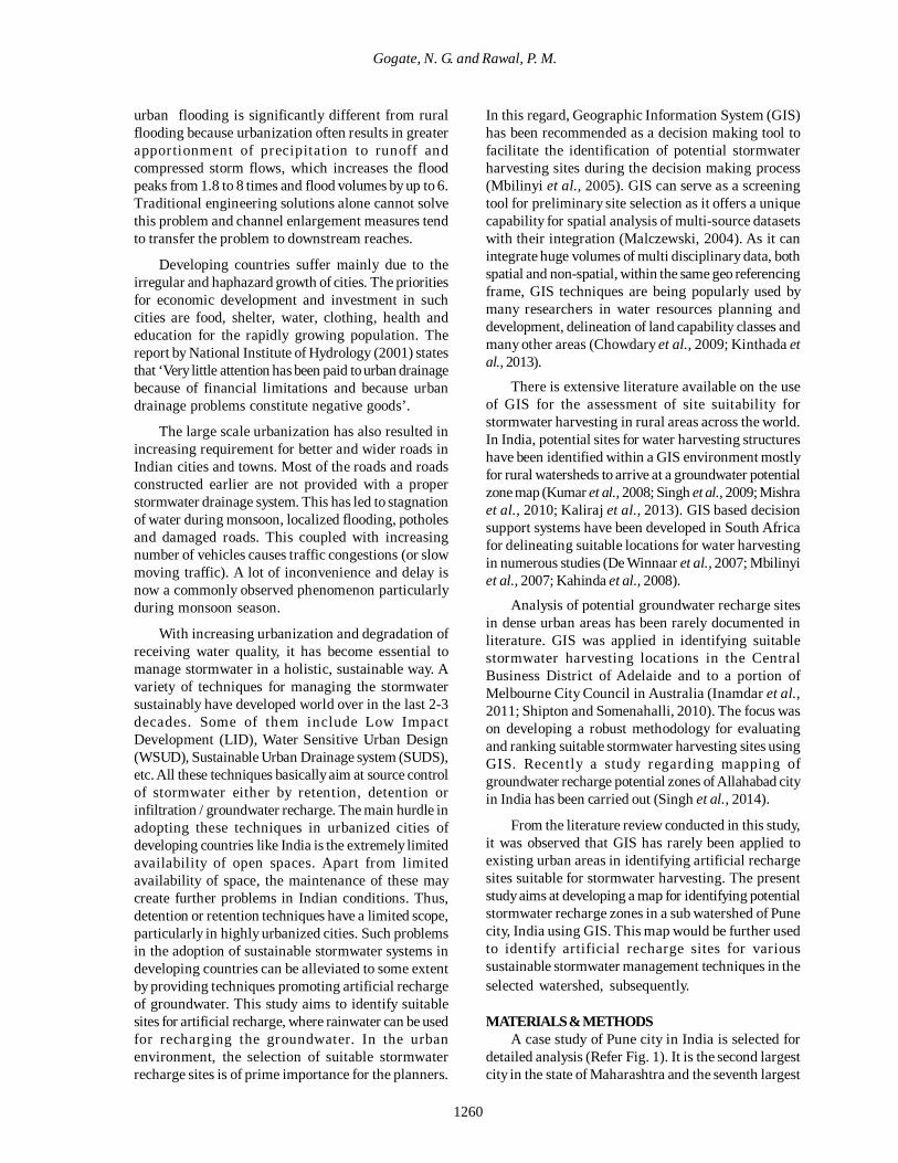
The large scale urbanization has also resulted inincreasing requirement for better and wider roads inIndian cities and towns Most of the roads and roadsconstructed earlier are not provided with a properstormwater drainage system This has led to stagnationof water during monsoon localized flooding potholesand damaged roads This coupled with increasingnumber of vehicles causes traffic congestions (or slowmoving traffic) A lot of inconvenience and delay isnow a commonly observed phenomenon particularlyduring monsoon season
With increasing urbanization and degradation ofreceiving water quality it has become essential tomanage stormwater in a holistic sustainable way Avariety of techniques for managing the stormwatersustainably have developed world over in the last 2-3decades Some of them include Low ImpactDevelopment (LID) Water Sensitive Urban Design(WSUD) Sustainable Urban Drainage system (SUDS)etc All these techniques basically aim at source controlof stormwater either by retention detention orinfiltration groundwater recharge The main hurdle inadopting these techniques in urbanized cities ofdeveloping countries like India is the extremely limitedavailability of open spaces Apart from limitedavailability of space the maintenance of these maycreate further problems in Indian conditions Thusdetention or retention techniques have a limited scopeparticularly in highly urbanized cities Such problemsin the adoption of sustainable stormwater systems indeveloping countries can be alleviated to some extentby providing techniques promoting artificial rechargeof groundwater This study aims to identify suitablesites for artificial recharge where rainwater can be usedfor recharging the groundwater In the urbanenvironment the selection of suitable stormwaterrecharge sites is of prime importance for the planners
In this regard Geographic Information System (GIS)has been recommended as a decision making tool tofacilitate the identification of potential stormwaterharvesting sites during the decision making process(Mbilinyi et al 2005) GIS can serve as a screeningtool for preliminary site selection as it offers a uniquecapability for spatial analysis of multi-source datasetswith their integration (Malczewski 2004) As it canintegrate huge volumes of multi disciplinary data bothspatial and non-spatial within the same geo referencingframe GIS techniques are being popularly used bymany researchers in water resources planning anddevelopment delineation of land capability classes andmany other areas (Chowdary et al 2009 Kinthada etal 2013)
There is extensive literature available on the useof GIS for the assessment of site suitability forstormwater harvesting in rural areas across the worldIn India potential sites for water harvesting structureshave been identified within a GIS environment mostlyfor rural watersheds to arrive at a groundwater potentialzone map (Kumar et al 2008 Singh et al 2009 Mishraet al 2010 Kaliraj et al 2013) GIS based decisionsupport systems have been developed in South Africafor delineating suitable locations for water harvestingin numerous studies (De Winnaar et al 2007 Mbilinyiet al 2007 Kahinda et al 2008)
Analysis of potential groundwater recharge sitesin dense urban areas has been rarely documented inliterature GIS was applied in identifying suitablestormwater harvesting locations in the CentralBusiness District of Adelaide and to a portion ofMelbourne City Council in Australia (Inamdar et al2011 Shipton and Somenahalli 2010) The focus wason developing a robust methodology for evaluatingand ranking suitable stormwater harvesting sites usingGIS Recently a study regarding mapping ofgroundwater recharge potential zones of Allahabad cityin India has been carried out (Singh et al 2014)
From the literature review conducted in this studyit was observed that GIS has rarely been applied toexisting urban areas in identifying artificial rechargesites suitable for stormwater harvesting The presentstudy aims at developing a map for identifying potentialstormwater recharge zones in a sub watershed of Punecity India using GIS This map would be further usedto identify artificial recharge sites for varioussustainable stormwater management techniques in theselected watershed subsequently
MATERIALS amp METHODSA case study of Pune city in India is selected for
detailed analysis (Refer Fig 1) It is the second largestcity in the state of Maharashtra and the seventh largest
1261
Int J Environ Res 9(43)1259-1268 Autumn 2015
city in India The current population of the city is 36million and is projected to be 77 million in year 2041There has been a two fold increase in built up area inless than a decade since 1999 (Desai et al 2009)
In Pune stormwater is being managed in thetraditional way by providing stormwater drains Thereare 362 km length natural streams in the city whichdrain the runoff in Mutha river (Oak 2010) Every yearduring monsoon the roads in the city are gettingdamaged with increasing number of potholes andcraters The Pune Municipal Corporation has come upwith an eightfold theory to explain this situationImproper stormwater drainage is cited amongst the top3 causes by the corporation in this regard (Pune MirrorAug 6 2013)
Increased urbanization in the city has resulted in arising demand for water in the city In Pune citygroundwater has emerged as an important source tomeet the water requirements of various sectors Punersquosgroundwater is disappearing fast due to increased usethrough wells and bore wells According toGroundwater Survey and Development Authority(GSDA) report groundwater levels in the city havedropped by more than 875 meters
It is now well established that the conventionalpractice of urban stormwater management contributesto the degradation of receiving waterways and itrsquosvalue as potential alternative water source is beingrecently recognized Consequently this conventionalpractice is increasingly considered out of touch withthe environmental values of society and impedes thebroader pursuit of advancing more sustainable urbanenvironments (Thomas et al 1997 Newman et al1999 Wong et al 2000)
Pune needs a paradigm shift in the way stormwateris managed currently One of the sustainable ways tomanage stormwater in such condition would bestormwater recharge This paper discusses the factorsaffecting stormwater recharge A case study of adrainage basin in Pune city is selected for detailedanalysis The aim is to identify potential stormwaterrecharge zones in the selected watershed on GISplatform
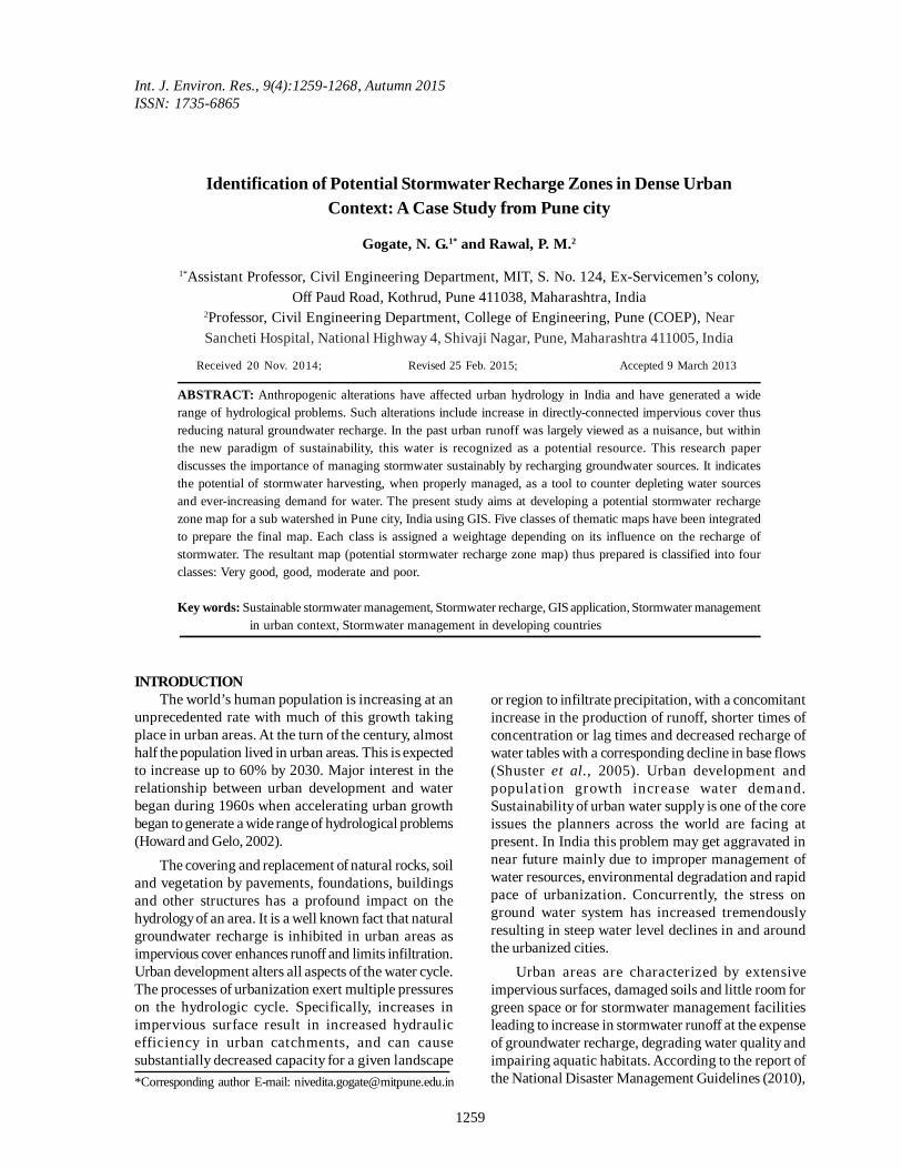
The selected Kothrud watershed (Basin lsquoBrsquo) inPune city is bounded by 18ordm291691 and18ordm3114357N latitudes and 73ordm46rsquo5191 and73ordm50684 E longitudes The total area covered by theselected drainage basin is 1171 sq km A drainage map
Fig 1 Location Sketch
Fig 2 Localized flooding Fig 3 Potholes and damaged roads
1262
Identification of Potential Stormwater Recharge Zones
of the study area prepared by Pune MunicipalCorporation (PMC) was used as a base map for thisstudy This map was geo referenced using Survey ofIndia toposheets (no 47F14 and 47F15) The studyarea is one of the 23 sub watersheds of Pune city Thisdrainage map along with the contours was digitizedand taken on GIS platform
The selection of suitable site for artificialgroundwater recharge depends on several parametersThe parameters that play an important role in siteselection are geological data geomorphological dataslope land useland cover water table level fluctuationetc Hence the required data for the selected catchmentwas collected from various sources namelyGroundwater Survey and Development Agency(GSDA) and Pune Municipal Corporation (PMC)
The methodology utilized for the present study isshown in Fig 4 The non-spatial data like well inventoryis converted into a thematic map of water levelfluctuation using well locations watershed areaboundary map and GIS software The spatial data likegeomorphology geology (Source GSDA) land-use(Source PMC) Slope (Source Survey of IndiaToposheets) etc has been digitized geo referencedand converted into thematic maps Each thematic maprepresents a parameter affecting the recharge potential
of the selected area These maps were classified byassigning a knowledge based ranking of one to threeone indicating highest influence and three the leastThe sub classes indicate the relative influence of eachon the stormwater recharge potential Each thematiclayer map was then assigned a weight depending onits influence on stormwater recharge using expertrsquosjudgement and literature All these classified andsuitably weighted thematic maps were then integratedusing GIS techniques GIS techniques involve theintegrated and conjunctive analysis of huge volumesof multi disciplinary data both spatial and non spatialwithin the same geo referencing scheme (Mishra etal 2010) Through integration of these datamanagement technologies potential stormwaterharvesting zones can be derived All the thematic mapswere integrated in GIS environment and the polygonshave been regrouped into different classes bycalculating score of each which depends on its rank
Fig 4 Flow chart depicting methodology adopted
Table 1 Ranking for slope map
Sr No Slope in Percentage
Ranking (In words)
Ranking (In numbers)
1 0 -3 Good 1 2 3 -5 Moderate 2 3 gt5 Poor 3
Fig 5 Slope Map
1263
Int J Environ Res 9(4)1259-1268 Autumn 2015
and layer weight The average score for very goodclass is 18 - 22 for good 16 to 18 for moderate 12 to 16and the other polygons having value between 8 -12were assigned to poor category The followingmethodology was adopted in the present study
1 Bringing the spatial and non-spatial data on to acommon GIS platform by digitizing and geo referencingwith the help of Survey of India toposheets
2 Preparation of various thematic maps for differentparameters influencing the recharge potential
3 Preparation of classified thematic maps by assigningknowledge based ranking of one to three to each classin the layers4 Assignment of appropriate weightages to all thelayers based on the influence of each parameter on therecharge potential5 Carry out multi criteria overlay analysis by integratingall the thematic maps in GIS environment6 Generate potential stormwater recharge zone mapfor the selected drainage basin
Table 2 Ranking for water level difference map
Sr No Pre and post monsoon water level difference (in m)
Ranking (In words)
Ranking (In numbers)
1 4 -5 Good 1 2 2 -3 Moderate 2 3 0 -1 Poor 3
Fig 6 Summer water level map Fig 7 Winter water level map
Fig 8 Map showing pre and post monsoon waterlevel difference
Fig 9 Geomorphology Map
1264
Gogate N G and Rawal P M
Slope in a given catchment has a direct effect onthe runoff quantity or indirectly controls the infiltrationThe Kothrud drainage basin map was scanned andfirst geo-referenced to the specific coordinates Thecontour map was then clipped to the drainage basin(watershed) boundary map and a Digital ElevationModel (DEM) in the GIS environment was generatedThe slope map was then generated from the DEM Slopeplays a key role in stormwater recharge as infiltrationis inversely related to slope (Mondal et al 2009) Thebreak in slope from steep slope to gentler slopeincreases the groundwater infiltration (Todd and Mays2005) The slope map was reclassified into threecategories as good moderate and poor by assigningranks to percent slope values (Refer Table 1)
Well inventory of the given area was studied andthe well location and pre and post monsoon water leveldata for those wells was extracted from it The welllocations were marked on the study area map The
summer water level ranged from 3 to 9m and winterwater level was observed to be in the range of 14 to73m This data was used for generation of thematicmaps for summer (pre-monsoon) water level winter(post-monsoon) water level and fluctuation in the waterlevel before and after monsoon season The water levelfluctuation data is an important factor in determiningrecharge potential of the area since it indicates theaverage water table level and recharge taking place inthe selected drainage basin The water level differencethematic map was generated using the pre and postmonsoon water level maps and was classified into 3classes as good moderate and poor based on waterlevel difference values (Refer Table 2)
Landforms have a different type of impact on therecharge and runoff patterns and hence should beconsidered independently The runoff generation andinfiltration is a dependent factor and is affected by thetype of landform Hence geomorphology is considered
Table 3 Ranking for geomorphological units
Sr No Geomorphologic unit Ranking (In words)
Ranking (In numbers)
1 Weathered Plateau (1-2m) Good 1 2 Canal Command Good 2 3 Plateau Undissected and moderately weathered Moderate 2 4 Mesa Poor 3 5 Butte Poor 3 6 Escarpment slope Poor 3
Table 4 Ranking for recharge condition classes
Sr No Description Ranking (In words)
Ranking (In numbers)
1 Favourable zone for groundwater development Good 1
2 Groundwater prospects good along
lineaments but not suitable for large scale groundwater development
Good 1
3 Moderate yield expected Moderate 2
4 Form runoff zone Not suitable for groundwater development Poor 3
Fig 10 Recharge condition Map
Fig 11 Landuse Map
1265
Int J Environ Res 9(4)1259-1268 Autumn 2015
as a separate thematic layer In a study by Sargaonkaret al (2011) Analytical Hierarchy Process (AHP) wasapplied for evaluating potential sites for groundwaterrecharge with respect to a number of criteria and thehighest priority was obtained for the criteriageomorphologyThe geomorphology map of the Puneregion was obtained from GSDA This map wasscanned digitized geo referenced using SOItoposheets and taken on GIS platform By clippingstudy area boundary map geomorphology map of thestudy area was generated The study area consists ofa range of landforms including butte mesa escarpmentslope and plateau The hilly areas express differentforms The hilly region in the study area includes a flattopped mesa butte and hills showing rollingtopography Butte landform can be seen in the northwestern part of the study area This shows poorpotential for recharge The rest of the study area iscovered by plateau region with various levels ofweathering Weathered regions are considered to begood for recharge By extraction of various classesof geomorphology a thematic map forgeomorphology was generated as per Fig 9 Theclassified geomorphology thematic map layer wasobtained by assigning knowledge based ranks tothe individual landform according to its relativeinfluence on recharge with highest value to the featureshowing maximum potential for recharge as given inTable 3
The actual recharge will also depend upon the levelof weathering of the strata available soil condition
and the possibility of groundwater development Thethematic map on recharge condition indicates therecharge potential based on this aspect The rechargecondition map of Pune region was obtained fromGSDA scanned and digitized using SOI toposheetsThis map was taken on GIS platform and watershedboundary map was clipped to it This thematic mapwas also classified into 3 classes based on its influenceon the recharge potential using the attribute data andjudgement of experts from GSDA as given in Table 4
The landuse in the selected area affects theopportunities available for recharge of stormwaterThus the landuse map of the area was acquired fromPune Municipal Corporation (PMC) scanned geo-referenced digitized and clipped with study areaboundary map to generate a landuse thematic mapThe area was classified into various categoriesincluding residential industrial open forest barrenetc Each category was then evaluated for its impacton the recharge potential (Refer Table 5) and the finallanduse map having 3 classes (good moderate andpoor) was generated
RESULTS amp DISCUSSIONThe stormwater recharge potential in a given area
is affected by a number of parameters Each parameterinfluences the recharge potential and the relativeinfluence of each parameter is different Hence weightswere assigned to each thematic layer indicating itsrelative importance in determining recharge potentialSince pre and post monsoon water level difference andslope are the most important parameters affecting therecharge potential maximum weight was assigned tothese two thematic layers The rest of the thematiclayers were assigned a lower weight Each thematiclayer is classified into 3 sub classes Based on theassigned ranks for each class and the weights assignedto each layer the total scores of the final integratedmap were derived as sum or product of the weightsassigned to the different layers and sub classes thereinaccording to their suitability All the thematic mapswere converted into raster format and superimposedby weighted overlay method using spatial analystextension of ArcGIS software This involves amulticriteria analysis using ranks and weightagesassigned to each thematic layer and their integrationthrough GIS The final recharge potential map wasderived from this multi criteria overlay analysis
Table 5 Ranking for landuse classes
Sr No Description Ranking (In words)
Ranking (In numbers)
1 Open area Good 1 2 Forest Barren land Urban residential Moderate 2 3 Industrial Barren rocky Hill forest Poor 3
Fig 12 Final Stormwater Recharge Zone Map
1266
Identification of Potential Stormwater Recharge Zones
incorporating all thematic layers along with their relativeranks and weights This map is classified into 4categories very good good moderate and poor basedon the final scores
Urban centers in India are facing an ironicalsituation with regard to water today On one hand thereis acute water scarcity and on the other the streets areoften flooded during the monsoons Management ofstormwater has become a difficult task in developingcountries like India and many factors are responsiblefor this condition The major factor giving rise to mostof the problems is uncontrolled urban expansionresulting into inadequate infrastructure and other basicfacilities The massive urbanization in India hasresulted in generation of huge quantities of stormwaterwhich are unutilized and polluted Although engineeredinfrastructure is a necessary component for drainageof urban runoff nonstructural approaches areimportant complementary measures focusing onactions to prevent and mitigate problems related toflooding as well as those related to pollution anddeterioration in environmental health conditions Inthe past urban runoff was largely viewed as a nuisancebut within the new paradigm of sustainability this wateris recognized as a potential resource According toMr S K Jain former groundwater resources expert withthe Ministry of Water Resources India road-siderainwater harvesting (RWH) has the potential togenerate more than 500 billion cubic meters ofadditional groundwater in the country if adopted in allcity roads including national and state highways(Down to Earth September 2010) As an alternativeparadigm for more sustainable water availabilityharvesting rainwater storing it in tanks and recharginggroundwater may be put in place
In Pune stormwater is being managed in thetraditional way by providing stormwater drains It wasobserved that the existing capacity of these drains isinadequate at many places to accommodate theincreasing volume of stormwater The uncontrolledurban development has left very few open spaces toaccommodate retention and detention devices Withdepleting water resources increasing water demandand flooding and water logging problems unutilizedstormwater needs to be harvested This type ofintegrated study will help in designing a sustainablesystem for managing stormwater in urban centers
Conventionally decisions regarding the locationand type of stormwater recharge technique could bemade only after extensive ground study This takes upa lot of time and investment The current multi-parametric approach using GIS is holistic in natureThis will help the planners in identifying suitable site-specific stormwater recharge techniques on a regional
as well as local scale thus enabling quick decision-making for sustainable stormwater management
CONCLUSIONSWater management is very critical for the growth
and development of any economy more so in adeveloping country like India However this resourceis now under stress because of excessive groundwaterabstraction for meeting increasing needs of growingpopulation and very low recharge because of highpercentage of impervious areas Therefore waterresources need to be conserved better managed andrecharged to accommodate the growing needs ofurbanization in a sustainable way
The selection of suitable stormwater harvestingsites is an essential and challenging requirement GISand remote sensing techniques have been used toselect artificial recharge sites in rural areas and derivedresults have been verified by ground truth fieldverification Recently this technique has been appliedto urban areas and has been found to be successfulthere (Inamdar et al 2011)
This study demonstrates application of GIStechnique in the identification of potential stormwaterrecharge zones in the selected Kothrud drainage basinin Pune India This study presents the application ofthis technique to urban areas for managing thestormwater sustainably The potential stormwaterrecharge zone map presents the delineation of selectedkothrud drainage basin into various classes Each classindicates suitability of that zone for recharge ofstormwater
The present study focuses on an area which isfrom a rapidly urbanizing and growing city of IndiaSince most of the study area is residential availabilityof rainwater from the roof-top is very high Thisrainwater can be managed at source by using LowImpact Development (LID) techniques that promoterecharge This stormwater which otherwise is notmanaged properly creates lots of problems Indeveloping countries like India conventional systemsfor managing stormwater are slowly beingimplemented Managing stormwater sustainably is theneed of the hour This stormwater can be diverted andused for artificial recharge Based on the potentialstormwater recharge zone map generated in the presentstudy various techniques can be identified to harvestrooftop rainwater as well as stormwater generated fromother impervious areas before it reaches the naturaldrains This harvested stormwater can be either storedand utilized as an alternative source of water or can beused to recharge groundwater The problems indeveloping countries are very different from developedcountries and solutions adopted there should not be
1267
Int J Environ Res 9(4)1259-1268 Autumn 2015
blindly applied to developing countries This type ofstudy can be used as a decision support tool inmanaging stormwater sustainably in dense urban areasof developing countries
The GIS screening tool methodology has provideda rational approach in identifying potential sites forstormwater harvesting in existing urban areas Thismap along with the landuse map can be used to developsuitable techniques which promote recharge and theirappropriate location for sustainable management ofstormwater subsequently
ACKNOWLEDGEMENTSWe thank Chetan Mahadik from GIS APP Pune for
his GIS related assistance
REFERENCESChowdary V M Ramakrishnan D Srivastava Y K VinuC and Jeyaram A (2009) Integrated water resourcedevelopment plan for sustainable management ofMayurakshi watershed India using remote sensing and GISJournal Water Resources Management 23(8) 1581-1602
Desai C G Patil M B Mahale V D and Umrikar B(2009) Application of remote sensing and geographicinformation system to study land use land cover changesa case study of Pune Metropolis Advances in ComputationalResearch 1(2) 10-13
De Winnaar G Jewitt GPW and Horan M (2007) A GIS-based approach for identifying potential runoff harvesting sitesin the Thukela River basin South Africa Physics andChemistry of the Earth Parts ABC 32(15-18) 1058-67
Howard KWF (2007) Urban Groundwater- Meeting theChallenge (London UK Taylor amp Francis Group)
Howard KWF and Gelo KK (2002) Intensivegroundwater use in urban areas the case of megacities (InR Llamas and E Custodio (Eds) Intensive use ofgroundwater challenges and opportunities (p 484)Netherlands A A Balkema Publishers)
Inamdar P M Cook S Sharma A Corby N OrsquoConnorJ and Pereraa B J C (2011 December) Development ofa GIS based screening tool for evaluating stormwaterharvesting sites in urban areas (Paper presented at the 19thInternational Congress on Modelling and Simulation PerthAustralia)
httpmssanzorgaumodsim2011
Kahinda J Lillie E Taigbenu A Taute M and BorotoR (2008) Developing suitability maps for rainwaterharvesting in South Africa Physics and Chemistry of theEarth 33(8-13) 788-799
Kaliraj S Chandrasekar N and Magesh N S (2013)Identification of potential groundwater recharge zones inVaigai upper basin Tamilnadu using GIS-based AnalyticalHierarchical Process (AHP) technique Arabian Journal ofGeosciences DOI 101007s12517-013-0849-x
Kinthada N R Gurram M K Eedara A and Rao V V(2013) Remote sensing and GIS in the geomorphometricanalysis of micro watersheds for hydrological scenarioassessment and characterization ndash A study on Sarada riverbasin Visakhapatnam district India International Journalof Geomatics and Geosciences 4(1)
Kumar M G Agarwal A K and Rameshwar B (2008)Delineation of Potential Sites for Water Harvesting Structuresusing Remote Sensing and GIS J Indian Soc Remote Sens36 323ndash334
Leopold L B (1968) Hydrogeology for urban land planningndash A guidebook on the hydrologic effects of urban land useUS Geological Survey Circular 554 18 httppubsusgsgovcirc19680554reportpdf
Leopold L B (1973) River channel change with time anexample Geological Society of America Bulletin 84(6) 1845ndash1860
Malczewski J (2004) GIS-based land-use suitability analysisa critical overview Progress in Planning 62(1) 3-65
Mbilinyi B Tumbo S Mahoo H Senkondo E and HatibuN (2005) Indigenous knowledge as decision support tool inrainwater harvesting Physics and Chemistry of the Earth30(11-16) 792-798
Mbilinyi BP Tumbo SD Mahoo HF and MkiramwinyiFO (2007) GIS-based decision support system for identifyingpotential sites for rainwater harvesting Physics and Chemistryof the Earth Parts
ABC 32(15-18) 1074-81
Mishra R C Biju C and Naik R D (2010) Remote Sensingand GIS for Groundwater Mapping and Identification ofArtificial Recharge Sites Geoenvironmental Engineering andGeotechnics 216-223 doi10106141105(378)30
Mondal M S Pandey A C and Garg R D (2009)Groundwater prospects evaluation based onhydrogeomorphological mapping using high resolutionsatellite images a case study in Uttarakhand J Indian SocRemote Sens 3669ndash76
National Disaster Management Guidelines Management ofUrban Flooding (2010 September) A publication of theNational Disaster Management Authority Government ofIndia ISBN 978-93-80440-09-5 New Delhi
National Institute of Hydrology (2001) Urban HydrologyA State of the Art Report (Roorkee)
Newman P and Kenworthy J (1999) Sustainability andcities Overcoming automobile dependence (WashingtonDC Island Press)
Oak A (2010) Drainage Plan for Pune City PrimoveConsultants Pvt Ltd Pune
Sargaonkar A P Rathi B and Baile A (2011) Identifyingpotential sites for artificial groundwater recharge in sub-watershed of River Kanhan India Environ Earth Sci621099ndash1108 DOI 101007s12665-010-0598-z
1268
Gogate N G and Rawal P M
Shipton MD and Somenahalli SVC (2010) Locatingappraising and optimizing urban storm water
harvesting sites Retrieved Sepetember 7 2014 from httpwwwesricomnewsarcnewsspring10articleslocating-appraisinghtml
Shuster W D Bonta J Thurston H Warnemuende Eand Smith D R (2005) Impacts of impervious surface onwatershed hydrology A review Urban Water Journal 24263-275 DOI 10108015730620500386529
Singh S Samaddar A B Srivastava R K and Pandey HK (2014) Ground Water Recharge in Urban Areas ndashExperience of Rain Water Harvesting Journal GeologicalSociety of India 83 295-302
Singh J Singh D and Litoria P (2009) Selection of suitablesites for water harvesting structures in Soankhad watershed
Punjab using remote sensing and geographical informationsystem (RSampGIS) approachmdasha case study Journal of theIndian Society of Remote Sensing 37(1) 21-35
Thomas J F Gomboso J Oliver J E and Ritchie V A(1997) Wastewater re-use stormwater management and thenational water reform agenda (In Report to the SustainableLand and Water Resources Management Committee and tothe Council of Australian Governments National WaterReform Task Force Background positions paper 1 CSIROLand and Water Canberra)
Todd D K Mays L W (2005) Groundwater hydrology(New York Wiley)
Wong T H F Eadie M L (2000) Water sensitive urbandesignmdashA paradigm shift in urban design (Paper in CDROM presented at The International Water ResourcesAssociation for the Xth World Water Congress Melbourne)
1260
Gogate N G and Rawal P M
urban flooding is significantly different from ruralflooding because urbanization often results in greaterapportionment of precipitation to runoff andcompressed storm flows which increases the floodpeaks from 18 to 8 times and flood volumes by up to 6Traditional engineering solutions alone cannot solvethis problem and channel enlargement measures tendto transfer the problem to downstream reaches
Developing countries suffer mainly due to theirregular and haphazard growth of cities The prioritiesfor economic development and investment in suchcities are food shelter water clothing health andeducation for the rapidly growing population Thereport by National Institute of Hydrology (2001) statesthat lsquoVery little attention has been paid to urban drainagebecause of financial limitations and because urbandrainage problems constitute negative goodsrsquo
The large scale urbanization has also resulted inincreasing requirement for better and wider roads inIndian cities and towns Most of the roads and roadsconstructed earlier are not provided with a properstormwater drainage system This has led to stagnationof water during monsoon localized flooding potholesand damaged roads This coupled with increasingnumber of vehicles causes traffic congestions (or slowmoving traffic) A lot of inconvenience and delay isnow a commonly observed phenomenon particularlyduring monsoon season
With increasing urbanization and degradation ofreceiving water quality it has become essential tomanage stormwater in a holistic sustainable way Avariety of techniques for managing the stormwatersustainably have developed world over in the last 2-3decades Some of them include Low ImpactDevelopment (LID) Water Sensitive Urban Design(WSUD) Sustainable Urban Drainage system (SUDS)etc All these techniques basically aim at source controlof stormwater either by retention detention orinfiltration groundwater recharge The main hurdle inadopting these techniques in urbanized cities ofdeveloping countries like India is the extremely limitedavailability of open spaces Apart from limitedavailability of space the maintenance of these maycreate further problems in Indian conditions Thusdetention or retention techniques have a limited scopeparticularly in highly urbanized cities Such problemsin the adoption of sustainable stormwater systems indeveloping countries can be alleviated to some extentby providing techniques promoting artificial rechargeof groundwater This study aims to identify suitablesites for artificial recharge where rainwater can be usedfor recharging the groundwater In the urbanenvironment the selection of suitable stormwaterrecharge sites is of prime importance for the planners
In this regard Geographic Information System (GIS)has been recommended as a decision making tool tofacilitate the identification of potential stormwaterharvesting sites during the decision making process(Mbilinyi et al 2005) GIS can serve as a screeningtool for preliminary site selection as it offers a uniquecapability for spatial analysis of multi-source datasetswith their integration (Malczewski 2004) As it canintegrate huge volumes of multi disciplinary data bothspatial and non-spatial within the same geo referencingframe GIS techniques are being popularly used bymany researchers in water resources planning anddevelopment delineation of land capability classes andmany other areas (Chowdary et al 2009 Kinthada etal 2013)
There is extensive literature available on the useof GIS for the assessment of site suitability forstormwater harvesting in rural areas across the worldIn India potential sites for water harvesting structureshave been identified within a GIS environment mostlyfor rural watersheds to arrive at a groundwater potentialzone map (Kumar et al 2008 Singh et al 2009 Mishraet al 2010 Kaliraj et al 2013) GIS based decisionsupport systems have been developed in South Africafor delineating suitable locations for water harvestingin numerous studies (De Winnaar et al 2007 Mbilinyiet al 2007 Kahinda et al 2008)
Analysis of potential groundwater recharge sitesin dense urban areas has been rarely documented inliterature GIS was applied in identifying suitablestormwater harvesting locations in the CentralBusiness District of Adelaide and to a portion ofMelbourne City Council in Australia (Inamdar et al2011 Shipton and Somenahalli 2010) The focus wason developing a robust methodology for evaluatingand ranking suitable stormwater harvesting sites usingGIS Recently a study regarding mapping ofgroundwater recharge potential zones of Allahabad cityin India has been carried out (Singh et al 2014)
From the literature review conducted in this studyit was observed that GIS has rarely been applied toexisting urban areas in identifying artificial rechargesites suitable for stormwater harvesting The presentstudy aims at developing a map for identifying potentialstormwater recharge zones in a sub watershed of Punecity India using GIS This map would be further usedto identify artificial recharge sites for varioussustainable stormwater management techniques in theselected watershed subsequently
MATERIALS amp METHODSA case study of Pune city in India is selected for
detailed analysis (Refer Fig 1) It is the second largestcity in the state of Maharashtra and the seventh largest
1261
Int J Environ Res 9(43)1259-1268 Autumn 2015
city in India The current population of the city is 36million and is projected to be 77 million in year 2041There has been a two fold increase in built up area inless than a decade since 1999 (Desai et al 2009)
In Pune stormwater is being managed in thetraditional way by providing stormwater drains Thereare 362 km length natural streams in the city whichdrain the runoff in Mutha river (Oak 2010) Every yearduring monsoon the roads in the city are gettingdamaged with increasing number of potholes andcraters The Pune Municipal Corporation has come upwith an eightfold theory to explain this situationImproper stormwater drainage is cited amongst the top3 causes by the corporation in this regard (Pune MirrorAug 6 2013)
Increased urbanization in the city has resulted in arising demand for water in the city In Pune citygroundwater has emerged as an important source tomeet the water requirements of various sectors Punersquosgroundwater is disappearing fast due to increased usethrough wells and bore wells According toGroundwater Survey and Development Authority(GSDA) report groundwater levels in the city havedropped by more than 875 meters
It is now well established that the conventionalpractice of urban stormwater management contributesto the degradation of receiving waterways and itrsquosvalue as potential alternative water source is beingrecently recognized Consequently this conventionalpractice is increasingly considered out of touch withthe environmental values of society and impedes thebroader pursuit of advancing more sustainable urbanenvironments (Thomas et al 1997 Newman et al1999 Wong et al 2000)
Pune needs a paradigm shift in the way stormwateris managed currently One of the sustainable ways tomanage stormwater in such condition would bestormwater recharge This paper discusses the factorsaffecting stormwater recharge A case study of adrainage basin in Pune city is selected for detailedanalysis The aim is to identify potential stormwaterrecharge zones in the selected watershed on GISplatform
The selected Kothrud watershed (Basin lsquoBrsquo) inPune city is bounded by 18ordm291691 and18ordm3114357N latitudes and 73ordm46rsquo5191 and73ordm50684 E longitudes The total area covered by theselected drainage basin is 1171 sq km A drainage map
Fig 1 Location Sketch
Fig 2 Localized flooding Fig 3 Potholes and damaged roads
1262
Identification of Potential Stormwater Recharge Zones
of the study area prepared by Pune MunicipalCorporation (PMC) was used as a base map for thisstudy This map was geo referenced using Survey ofIndia toposheets (no 47F14 and 47F15) The studyarea is one of the 23 sub watersheds of Pune city Thisdrainage map along with the contours was digitizedand taken on GIS platform
The selection of suitable site for artificialgroundwater recharge depends on several parametersThe parameters that play an important role in siteselection are geological data geomorphological dataslope land useland cover water table level fluctuationetc Hence the required data for the selected catchmentwas collected from various sources namelyGroundwater Survey and Development Agency(GSDA) and Pune Municipal Corporation (PMC)
The methodology utilized for the present study isshown in Fig 4 The non-spatial data like well inventoryis converted into a thematic map of water levelfluctuation using well locations watershed areaboundary map and GIS software The spatial data likegeomorphology geology (Source GSDA) land-use(Source PMC) Slope (Source Survey of IndiaToposheets) etc has been digitized geo referencedand converted into thematic maps Each thematic maprepresents a parameter affecting the recharge potential
of the selected area These maps were classified byassigning a knowledge based ranking of one to threeone indicating highest influence and three the leastThe sub classes indicate the relative influence of eachon the stormwater recharge potential Each thematiclayer map was then assigned a weight depending onits influence on stormwater recharge using expertrsquosjudgement and literature All these classified andsuitably weighted thematic maps were then integratedusing GIS techniques GIS techniques involve theintegrated and conjunctive analysis of huge volumesof multi disciplinary data both spatial and non spatialwithin the same geo referencing scheme (Mishra etal 2010) Through integration of these datamanagement technologies potential stormwaterharvesting zones can be derived All the thematic mapswere integrated in GIS environment and the polygonshave been regrouped into different classes bycalculating score of each which depends on its rank
Fig 4 Flow chart depicting methodology adopted
Table 1 Ranking for slope map
Sr No Slope in Percentage
Ranking (In words)
Ranking (In numbers)
1 0 -3 Good 1 2 3 -5 Moderate 2 3 gt5 Poor 3
Fig 5 Slope Map
1263
Int J Environ Res 9(4)1259-1268 Autumn 2015
and layer weight The average score for very goodclass is 18 - 22 for good 16 to 18 for moderate 12 to 16and the other polygons having value between 8 -12were assigned to poor category The followingmethodology was adopted in the present study
1 Bringing the spatial and non-spatial data on to acommon GIS platform by digitizing and geo referencingwith the help of Survey of India toposheets
2 Preparation of various thematic maps for differentparameters influencing the recharge potential
3 Preparation of classified thematic maps by assigningknowledge based ranking of one to three to each classin the layers4 Assignment of appropriate weightages to all thelayers based on the influence of each parameter on therecharge potential5 Carry out multi criteria overlay analysis by integratingall the thematic maps in GIS environment6 Generate potential stormwater recharge zone mapfor the selected drainage basin
Table 2 Ranking for water level difference map
Sr No Pre and post monsoon water level difference (in m)
Ranking (In words)
Ranking (In numbers)
1 4 -5 Good 1 2 2 -3 Moderate 2 3 0 -1 Poor 3
Fig 6 Summer water level map Fig 7 Winter water level map
Fig 8 Map showing pre and post monsoon waterlevel difference
Fig 9 Geomorphology Map
1264
Gogate N G and Rawal P M
Slope in a given catchment has a direct effect onthe runoff quantity or indirectly controls the infiltrationThe Kothrud drainage basin map was scanned andfirst geo-referenced to the specific coordinates Thecontour map was then clipped to the drainage basin(watershed) boundary map and a Digital ElevationModel (DEM) in the GIS environment was generatedThe slope map was then generated from the DEM Slopeplays a key role in stormwater recharge as infiltrationis inversely related to slope (Mondal et al 2009) Thebreak in slope from steep slope to gentler slopeincreases the groundwater infiltration (Todd and Mays2005) The slope map was reclassified into threecategories as good moderate and poor by assigningranks to percent slope values (Refer Table 1)
Well inventory of the given area was studied andthe well location and pre and post monsoon water leveldata for those wells was extracted from it The welllocations were marked on the study area map The
summer water level ranged from 3 to 9m and winterwater level was observed to be in the range of 14 to73m This data was used for generation of thematicmaps for summer (pre-monsoon) water level winter(post-monsoon) water level and fluctuation in the waterlevel before and after monsoon season The water levelfluctuation data is an important factor in determiningrecharge potential of the area since it indicates theaverage water table level and recharge taking place inthe selected drainage basin The water level differencethematic map was generated using the pre and postmonsoon water level maps and was classified into 3classes as good moderate and poor based on waterlevel difference values (Refer Table 2)
Landforms have a different type of impact on therecharge and runoff patterns and hence should beconsidered independently The runoff generation andinfiltration is a dependent factor and is affected by thetype of landform Hence geomorphology is considered
Table 3 Ranking for geomorphological units
Sr No Geomorphologic unit Ranking (In words)
Ranking (In numbers)
1 Weathered Plateau (1-2m) Good 1 2 Canal Command Good 2 3 Plateau Undissected and moderately weathered Moderate 2 4 Mesa Poor 3 5 Butte Poor 3 6 Escarpment slope Poor 3
Table 4 Ranking for recharge condition classes
Sr No Description Ranking (In words)
Ranking (In numbers)
1 Favourable zone for groundwater development Good 1
2 Groundwater prospects good along
lineaments but not suitable for large scale groundwater development
Good 1
3 Moderate yield expected Moderate 2
4 Form runoff zone Not suitable for groundwater development Poor 3
Fig 10 Recharge condition Map
Fig 11 Landuse Map
1265
Int J Environ Res 9(4)1259-1268 Autumn 2015
as a separate thematic layer In a study by Sargaonkaret al (2011) Analytical Hierarchy Process (AHP) wasapplied for evaluating potential sites for groundwaterrecharge with respect to a number of criteria and thehighest priority was obtained for the criteriageomorphologyThe geomorphology map of the Puneregion was obtained from GSDA This map wasscanned digitized geo referenced using SOItoposheets and taken on GIS platform By clippingstudy area boundary map geomorphology map of thestudy area was generated The study area consists ofa range of landforms including butte mesa escarpmentslope and plateau The hilly areas express differentforms The hilly region in the study area includes a flattopped mesa butte and hills showing rollingtopography Butte landform can be seen in the northwestern part of the study area This shows poorpotential for recharge The rest of the study area iscovered by plateau region with various levels ofweathering Weathered regions are considered to begood for recharge By extraction of various classesof geomorphology a thematic map forgeomorphology was generated as per Fig 9 Theclassified geomorphology thematic map layer wasobtained by assigning knowledge based ranks tothe individual landform according to its relativeinfluence on recharge with highest value to the featureshowing maximum potential for recharge as given inTable 3
The actual recharge will also depend upon the levelof weathering of the strata available soil condition
and the possibility of groundwater development Thethematic map on recharge condition indicates therecharge potential based on this aspect The rechargecondition map of Pune region was obtained fromGSDA scanned and digitized using SOI toposheetsThis map was taken on GIS platform and watershedboundary map was clipped to it This thematic mapwas also classified into 3 classes based on its influenceon the recharge potential using the attribute data andjudgement of experts from GSDA as given in Table 4
The landuse in the selected area affects theopportunities available for recharge of stormwaterThus the landuse map of the area was acquired fromPune Municipal Corporation (PMC) scanned geo-referenced digitized and clipped with study areaboundary map to generate a landuse thematic mapThe area was classified into various categoriesincluding residential industrial open forest barrenetc Each category was then evaluated for its impacton the recharge potential (Refer Table 5) and the finallanduse map having 3 classes (good moderate andpoor) was generated
RESULTS amp DISCUSSIONThe stormwater recharge potential in a given area
is affected by a number of parameters Each parameterinfluences the recharge potential and the relativeinfluence of each parameter is different Hence weightswere assigned to each thematic layer indicating itsrelative importance in determining recharge potentialSince pre and post monsoon water level difference andslope are the most important parameters affecting therecharge potential maximum weight was assigned tothese two thematic layers The rest of the thematiclayers were assigned a lower weight Each thematiclayer is classified into 3 sub classes Based on theassigned ranks for each class and the weights assignedto each layer the total scores of the final integratedmap were derived as sum or product of the weightsassigned to the different layers and sub classes thereinaccording to their suitability All the thematic mapswere converted into raster format and superimposedby weighted overlay method using spatial analystextension of ArcGIS software This involves amulticriteria analysis using ranks and weightagesassigned to each thematic layer and their integrationthrough GIS The final recharge potential map wasderived from this multi criteria overlay analysis
Table 5 Ranking for landuse classes
Sr No Description Ranking (In words)
Ranking (In numbers)
1 Open area Good 1 2 Forest Barren land Urban residential Moderate 2 3 Industrial Barren rocky Hill forest Poor 3
Fig 12 Final Stormwater Recharge Zone Map
1266
Identification of Potential Stormwater Recharge Zones
incorporating all thematic layers along with their relativeranks and weights This map is classified into 4categories very good good moderate and poor basedon the final scores
Urban centers in India are facing an ironicalsituation with regard to water today On one hand thereis acute water scarcity and on the other the streets areoften flooded during the monsoons Management ofstormwater has become a difficult task in developingcountries like India and many factors are responsiblefor this condition The major factor giving rise to mostof the problems is uncontrolled urban expansionresulting into inadequate infrastructure and other basicfacilities The massive urbanization in India hasresulted in generation of huge quantities of stormwaterwhich are unutilized and polluted Although engineeredinfrastructure is a necessary component for drainageof urban runoff nonstructural approaches areimportant complementary measures focusing onactions to prevent and mitigate problems related toflooding as well as those related to pollution anddeterioration in environmental health conditions Inthe past urban runoff was largely viewed as a nuisancebut within the new paradigm of sustainability this wateris recognized as a potential resource According toMr S K Jain former groundwater resources expert withthe Ministry of Water Resources India road-siderainwater harvesting (RWH) has the potential togenerate more than 500 billion cubic meters ofadditional groundwater in the country if adopted in allcity roads including national and state highways(Down to Earth September 2010) As an alternativeparadigm for more sustainable water availabilityharvesting rainwater storing it in tanks and recharginggroundwater may be put in place
In Pune stormwater is being managed in thetraditional way by providing stormwater drains It wasobserved that the existing capacity of these drains isinadequate at many places to accommodate theincreasing volume of stormwater The uncontrolledurban development has left very few open spaces toaccommodate retention and detention devices Withdepleting water resources increasing water demandand flooding and water logging problems unutilizedstormwater needs to be harvested This type ofintegrated study will help in designing a sustainablesystem for managing stormwater in urban centers
Conventionally decisions regarding the locationand type of stormwater recharge technique could bemade only after extensive ground study This takes upa lot of time and investment The current multi-parametric approach using GIS is holistic in natureThis will help the planners in identifying suitable site-specific stormwater recharge techniques on a regional
as well as local scale thus enabling quick decision-making for sustainable stormwater management
CONCLUSIONSWater management is very critical for the growth
and development of any economy more so in adeveloping country like India However this resourceis now under stress because of excessive groundwaterabstraction for meeting increasing needs of growingpopulation and very low recharge because of highpercentage of impervious areas Therefore waterresources need to be conserved better managed andrecharged to accommodate the growing needs ofurbanization in a sustainable way
The selection of suitable stormwater harvestingsites is an essential and challenging requirement GISand remote sensing techniques have been used toselect artificial recharge sites in rural areas and derivedresults have been verified by ground truth fieldverification Recently this technique has been appliedto urban areas and has been found to be successfulthere (Inamdar et al 2011)
This study demonstrates application of GIStechnique in the identification of potential stormwaterrecharge zones in the selected Kothrud drainage basinin Pune India This study presents the application ofthis technique to urban areas for managing thestormwater sustainably The potential stormwaterrecharge zone map presents the delineation of selectedkothrud drainage basin into various classes Each classindicates suitability of that zone for recharge ofstormwater
The present study focuses on an area which isfrom a rapidly urbanizing and growing city of IndiaSince most of the study area is residential availabilityof rainwater from the roof-top is very high Thisrainwater can be managed at source by using LowImpact Development (LID) techniques that promoterecharge This stormwater which otherwise is notmanaged properly creates lots of problems Indeveloping countries like India conventional systemsfor managing stormwater are slowly beingimplemented Managing stormwater sustainably is theneed of the hour This stormwater can be diverted andused for artificial recharge Based on the potentialstormwater recharge zone map generated in the presentstudy various techniques can be identified to harvestrooftop rainwater as well as stormwater generated fromother impervious areas before it reaches the naturaldrains This harvested stormwater can be either storedand utilized as an alternative source of water or can beused to recharge groundwater The problems indeveloping countries are very different from developedcountries and solutions adopted there should not be
1267
Int J Environ Res 9(4)1259-1268 Autumn 2015
blindly applied to developing countries This type ofstudy can be used as a decision support tool inmanaging stormwater sustainably in dense urban areasof developing countries
The GIS screening tool methodology has provideda rational approach in identifying potential sites forstormwater harvesting in existing urban areas Thismap along with the landuse map can be used to developsuitable techniques which promote recharge and theirappropriate location for sustainable management ofstormwater subsequently
ACKNOWLEDGEMENTSWe thank Chetan Mahadik from GIS APP Pune for
his GIS related assistance
REFERENCESChowdary V M Ramakrishnan D Srivastava Y K VinuC and Jeyaram A (2009) Integrated water resourcedevelopment plan for sustainable management ofMayurakshi watershed India using remote sensing and GISJournal Water Resources Management 23(8) 1581-1602
Desai C G Patil M B Mahale V D and Umrikar B(2009) Application of remote sensing and geographicinformation system to study land use land cover changesa case study of Pune Metropolis Advances in ComputationalResearch 1(2) 10-13
De Winnaar G Jewitt GPW and Horan M (2007) A GIS-based approach for identifying potential runoff harvesting sitesin the Thukela River basin South Africa Physics andChemistry of the Earth Parts ABC 32(15-18) 1058-67
Howard KWF (2007) Urban Groundwater- Meeting theChallenge (London UK Taylor amp Francis Group)
Howard KWF and Gelo KK (2002) Intensivegroundwater use in urban areas the case of megacities (InR Llamas and E Custodio (Eds) Intensive use ofgroundwater challenges and opportunities (p 484)Netherlands A A Balkema Publishers)
Inamdar P M Cook S Sharma A Corby N OrsquoConnorJ and Pereraa B J C (2011 December) Development ofa GIS based screening tool for evaluating stormwaterharvesting sites in urban areas (Paper presented at the 19thInternational Congress on Modelling and Simulation PerthAustralia)
httpmssanzorgaumodsim2011
Kahinda J Lillie E Taigbenu A Taute M and BorotoR (2008) Developing suitability maps for rainwaterharvesting in South Africa Physics and Chemistry of theEarth 33(8-13) 788-799
Kaliraj S Chandrasekar N and Magesh N S (2013)Identification of potential groundwater recharge zones inVaigai upper basin Tamilnadu using GIS-based AnalyticalHierarchical Process (AHP) technique Arabian Journal ofGeosciences DOI 101007s12517-013-0849-x
Kinthada N R Gurram M K Eedara A and Rao V V(2013) Remote sensing and GIS in the geomorphometricanalysis of micro watersheds for hydrological scenarioassessment and characterization ndash A study on Sarada riverbasin Visakhapatnam district India International Journalof Geomatics and Geosciences 4(1)
Kumar M G Agarwal A K and Rameshwar B (2008)Delineation of Potential Sites for Water Harvesting Structuresusing Remote Sensing and GIS J Indian Soc Remote Sens36 323ndash334
Leopold L B (1968) Hydrogeology for urban land planningndash A guidebook on the hydrologic effects of urban land useUS Geological Survey Circular 554 18 httppubsusgsgovcirc19680554reportpdf
Leopold L B (1973) River channel change with time anexample Geological Society of America Bulletin 84(6) 1845ndash1860
Malczewski J (2004) GIS-based land-use suitability analysisa critical overview Progress in Planning 62(1) 3-65
Mbilinyi B Tumbo S Mahoo H Senkondo E and HatibuN (2005) Indigenous knowledge as decision support tool inrainwater harvesting Physics and Chemistry of the Earth30(11-16) 792-798
Mbilinyi BP Tumbo SD Mahoo HF and MkiramwinyiFO (2007) GIS-based decision support system for identifyingpotential sites for rainwater harvesting Physics and Chemistryof the Earth Parts
ABC 32(15-18) 1074-81
Mishra R C Biju C and Naik R D (2010) Remote Sensingand GIS for Groundwater Mapping and Identification ofArtificial Recharge Sites Geoenvironmental Engineering andGeotechnics 216-223 doi10106141105(378)30
Mondal M S Pandey A C and Garg R D (2009)Groundwater prospects evaluation based onhydrogeomorphological mapping using high resolutionsatellite images a case study in Uttarakhand J Indian SocRemote Sens 3669ndash76
National Disaster Management Guidelines Management ofUrban Flooding (2010 September) A publication of theNational Disaster Management Authority Government ofIndia ISBN 978-93-80440-09-5 New Delhi
National Institute of Hydrology (2001) Urban HydrologyA State of the Art Report (Roorkee)
Newman P and Kenworthy J (1999) Sustainability andcities Overcoming automobile dependence (WashingtonDC Island Press)
Oak A (2010) Drainage Plan for Pune City PrimoveConsultants Pvt Ltd Pune
Sargaonkar A P Rathi B and Baile A (2011) Identifyingpotential sites for artificial groundwater recharge in sub-watershed of River Kanhan India Environ Earth Sci621099ndash1108 DOI 101007s12665-010-0598-z
1268
Gogate N G and Rawal P M
Shipton MD and Somenahalli SVC (2010) Locatingappraising and optimizing urban storm water
harvesting sites Retrieved Sepetember 7 2014 from httpwwwesricomnewsarcnewsspring10articleslocating-appraisinghtml
Shuster W D Bonta J Thurston H Warnemuende Eand Smith D R (2005) Impacts of impervious surface onwatershed hydrology A review Urban Water Journal 24263-275 DOI 10108015730620500386529
Singh S Samaddar A B Srivastava R K and Pandey HK (2014) Ground Water Recharge in Urban Areas ndashExperience of Rain Water Harvesting Journal GeologicalSociety of India 83 295-302
Singh J Singh D and Litoria P (2009) Selection of suitablesites for water harvesting structures in Soankhad watershed
Punjab using remote sensing and geographical informationsystem (RSampGIS) approachmdasha case study Journal of theIndian Society of Remote Sensing 37(1) 21-35
Thomas J F Gomboso J Oliver J E and Ritchie V A(1997) Wastewater re-use stormwater management and thenational water reform agenda (In Report to the SustainableLand and Water Resources Management Committee and tothe Council of Australian Governments National WaterReform Task Force Background positions paper 1 CSIROLand and Water Canberra)
Todd D K Mays L W (2005) Groundwater hydrology(New York Wiley)
Wong T H F Eadie M L (2000) Water sensitive urbandesignmdashA paradigm shift in urban design (Paper in CDROM presented at The International Water ResourcesAssociation for the Xth World Water Congress Melbourne)
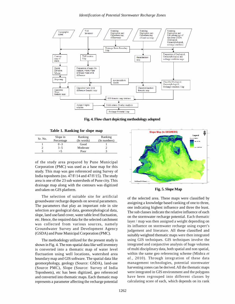
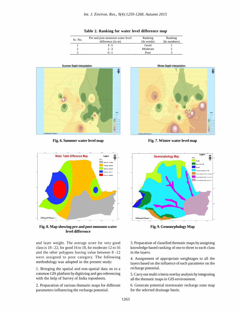
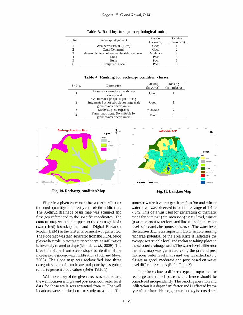
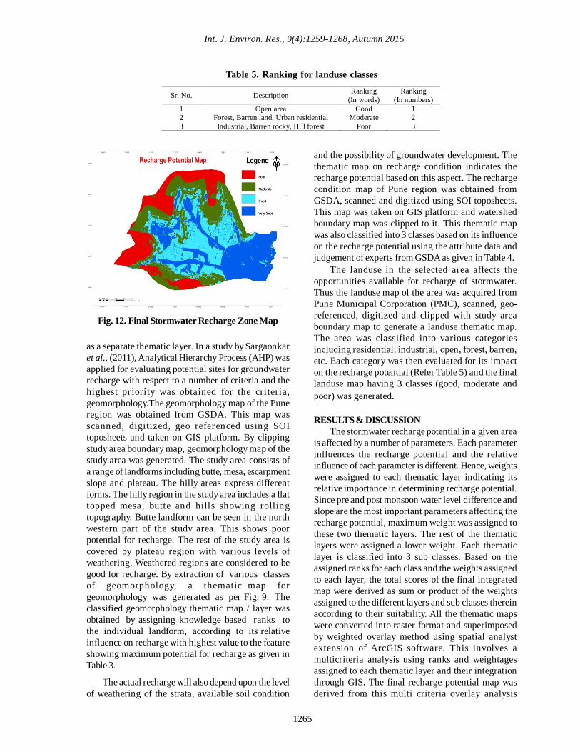