identidade, territóriu no prátika agrikulturál sira :...
TRANSCRIPT
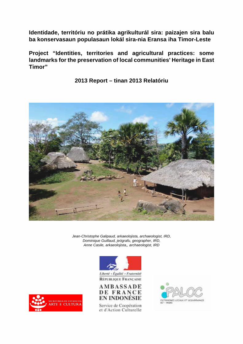
Identidade, territóriu no prátika agrikulturál sira: paizajen sira balu ba konservasaun populasaun lokál sira-nia Eransa iha Timor-Leste Project “Identities, territories and agricultural practices: some landmarks for the preservation of local communities' Heritage in East Timor”
2013 Report – tinan 2013 Relatóriu
Jean-Christophe Galipaud, arkaeolojista, archaeologist, IRD, Dominique Guillaud, jeógrafu, geographer, IRD, Anne Casile, arkaeolojista,, archaeologist, IRD
- 2 - - 2 --
Prefásiu (xamada-de-atensaun ba relatóriu prelimináriu tinan 2012) Timor-Leste lokaliza iha entrada estreitu Sudeste Aziátiku no Oseánia nia klaran. Iha liu rohan loron-saʼe nian iha illa sira Sunda nia leet, no la tama iha kosta norte Austrália nian, hatudu relasaun hamutuk hori uluk liu kedas entre rai ka mundu sira austronézias no Papuázia nian, no grupu linguístiku rua neʼe ezisti hamutuk iha país nia laran. Akontesimentu polítika sira resente nian iha dezordenamentu ba identidade kultura lokál sira no mós polítika nasionál ohin loron nian neʼebé eziji atu presiza hadiʼa fali. Objetivu ida-neʼe mai hasoru malu kedas ho kestaun sientífika ida, neʼebé parsialmente laiha resposta kona-ba dezafiadór sira no adaptasaun sira ema Austronéziu sira ho rai ka mundu Papua nian. Elementu balu neʼebé konsidera fundamentál para hodi komprende relasaun Timoroan sira-nian ba sira-nia rain: presiza halo estudu ida kona-ba pontu-de-vista lokál sira-nian kona-ba paizajen no territóriu para bele identifika fatin sira ka “jeosímbolu sira” neʼebé nakonu ho istória, mitos, májiku ka forsa neʼebé iha folin boot (importánsia) ba populasaun lokál sira. Elementus prinsipál husi territóriu endójenus sira-neʼe lokaliza iha fatin hirak-neʼe, mak hanesan fatin sagradu sira para sei hodi proteje tiha, fatin arkeolójiku sira-neʼebé sei hodi halo peskiza, rekursus barak no oioin, nst, no informa kona-ba grupu lokál (sira) neʼebé sira iha ba. Sistema agrikultura sira, no mós koñesimentu sira-neʼebé relasionadu ho sistema sira-neʼe, inskreve iha territóriu lokál hirak-neʼe, neʼebé organiza tiha haleʼu sira-nia núkleu (sentru) sira-neʼebé sagradu (lulik). Elementu hirak-neʼe hotu, fatin sira, sítiu, sistema no koñesimentu sira nuʼudar elementu prinsipál ba Timor-Leste ninia eransa no tenke hatene, proteje no valoriza tiha. Elementu hirak-neʼe bele fó pontu-marku sira ba polítika promosaun no protesaun patrimóniu istóriku ida kona-ba eransa nasionál paizajen sira-nian iha parte balu país nia laran. Aproximasaun ida-neʼe mós bele kontribui ba konsepsaun Sentru Kulturál Rejionál ida, neʼebé rezultadu sira-neʼe ida mak prevee polítika nasionál sira agora nian. Objetivu sira projetu neʼe nian mak: •Kria enkuadramentu ka kuadru kronolójiku ida ba ema nia hela-fatin ka okupasaun ema nian iha área neʼebé determina ona ba projetu neʼe. •Lokaliza fatin sira, lokál, koñesimentu, istória no elementu sira seluk, neʼebé iha sentidu ka valór ba populasaun siraʼnia identidade no direitus ba rai no mós identifika ameasa sira-neʼebé makaʼas ba sira. •Identifika no diskute element sira-neʼebé bele konsidera hanesan iha patrimóniu eransa boot ka potensiál ida (n.e. elementu sira-neʼebé investe ona ho valór neʼebé simbóliku no espesífiku, neʼebé iha jestaun koletivu ida no sei pasa ka fó daʼet ba jerasaun sira aban-bainrua nian); •Defini métodu ida ba komprensaun komunidade lokál sira-nian iha reprezentasaun sira territóriu nian, rai, fatin, ambiente, no mós kona-ba sira-nia tempu pasadu, no •Partisipa iha formasaun traballadór sira-nian iha área sira-neʼebé hili ka eskolla ona, hodi halo tuir rejistu ka inventáriu neʼe, aprezentasaun no
- 2 - - 2 --
valorizasaun ba patrimóniu nasionál no fasilita interkámbiu ho projetu sira jestaun patrimóniu eransa iha país sira seluk. Husi loron 25, fulan-Setembru toʼo loron 12, fulan-Outubru, tinan 2012, halaʼo tiha ona levantamentu primeiru ba área potensiál, hodi determina zona neʼebé detalladu no espesífiku ba investigasaun no indentifika informante potensiál sira. Rejiaun sira ida, neʼebé identifika ona ba investigasaun liután iha futuru mak área kárstika Balibo nian, fatin neʼebé autoridade lokál sira hetan ona informasaun ba ami-nia vizta neʼebé tuirmai sei halo iha fulan-Juñu 2013. Halo tiha ona viajen ida ba kampu iha fulan-Novembru, tinan 2013. Objetivu sira husi misaun tinan 2013 nian mak - Identifika no halo eskavasaun ba sítiu arkeolójiku sira-neʼebé relasionadu, hodi estabelese kronolojia ida ba organizasaun no definisaun nian no utilizasaun rai; defini ambiente sira-neʼebé relasionadu ho okupasaun sira-neʼebé akontese iha tempu antigun (bei-ala) sira-nian. - Halo estudu ba organizasaun territoriál atuál, no ninia ligasaun ho elementu arkaeolójiku no istóriku sira-nian. - Halo dokumentasaun ba elementu sira sistema subsisténsia bei-ala sira-nian balu neʼebé posivel. - Disemina rezultadu sira primeiru nian iha servisu ba kampu nian iha konferénsia TLSA iha Dili.
Asina MdE (MoU) entre Sekretaria Estadu ba Kultura no IRD neʼebé planeia tiha atu koinside ho misaun neʼe, ho Jean-Paul Toutain nia xegada, Reprezentante IRD iha Indonézia no Timor Leste, iha loron 8, fulan-Jullu.
- 3 - - 3 --
Itineráriu Loron 23-25, fulan-Juñu Kontaktu sira iha Dili: - Sekretaria Estadu ba Kultura: Cecilia Assis & Nuno Oliveira Loron 26, fulan-Juñu – loron 8, fulan-Jullu Vajen kampu ba Balibo Loron 10, fulan-Jullu Asinatura MdE (MoU) entre Sekretaria Estadu ba Kultura no IRD iha Dili Loron 11 – 14, fulan-Jullu Viajen kampu ba Balibo Loron 15-17, fulan-Jullu Konferénsia TLSA, Dili Loron 25-30, fulan-Novembru Viajen kampu ba Balibo, Leuhitu, Maliana Loron 2-9, fulan-Dezembru Viajen kampu ba rejiaun Viqueque Loron 10-11, fulan-Dezembru Dili; Enkontru ho Aurélie Seguin, no Timor Aid
Kontestu misaun sira-nian Misaun fulan-Juñu-Jullu nian komesa tiha ho rekoñmesimentu ida kona-ba formasaun sira kárstiku iha arredór sira aldeia Balibo nian ho ajuda husi ema hirak-neʼebé dezignadu husi (Anakletus da Silva, Xefe-Suco; Manoel da Cruz, Sekretáriu Suco; Silvester P) hodi identifika área sira-neʼe ho interese boot ba levantamentu/ peskiza arkaeolójiku sira-nian. Rekoñesimentu neʼe akompaña tiha ho enkontru ida neʼebé halaʼo ho líder tradisionál sira kona-ba área interesadu hirak-neʼe, neʼebé esplika tiha kona-ba prosesu no meius husi ami-nia aproximasaun neʼe, parabele hetan autorizasaun husi sira. Maria Verdal, Servisu Kultura Maliana nian, ajuda tiha ona ami iha prosesu neʼe. Depoizde serimónia tradisionál (abituál) sira, servisu sira komesa tiha ona iha loron 28, fulan-Juñu dadeer-saan. Rekruta tiha ema lokál hodi ajuda eskavasaun arkeolójiku sira no apoia ami iha rekoñesimentu sira seluk ba área neʼe. Eskavasaun sira-neʼe halaʼo tiha iha loron 28, fulan-Juñu toʼo loron 14, fulan-
- 4 - - 4 --
Jullu iha lokalidade rua besik Balibo, ho intervalu loron tolu iha Dili, hodi asina MdE (MoU). Lokalidade hirak-neʼe besik loos ho serimónia abituál sira. Iha fulan-Novembru, tinan 2013, viajen ida tan ba kampu iha Balibo permiti ami hodi relata rezultadu primeiru sira iha ami-nia peskiza ba komunidade lokál (ho kartáz ida neʼebé fó tiha ba eskritóriu suco), hodi habelar liután área peskiza neʼe no hodi halaʼo entrevista sira, ho finalidade hodi dokumenta estrutura sira organizasaun no sistema subsisténsia sira antigu nian.
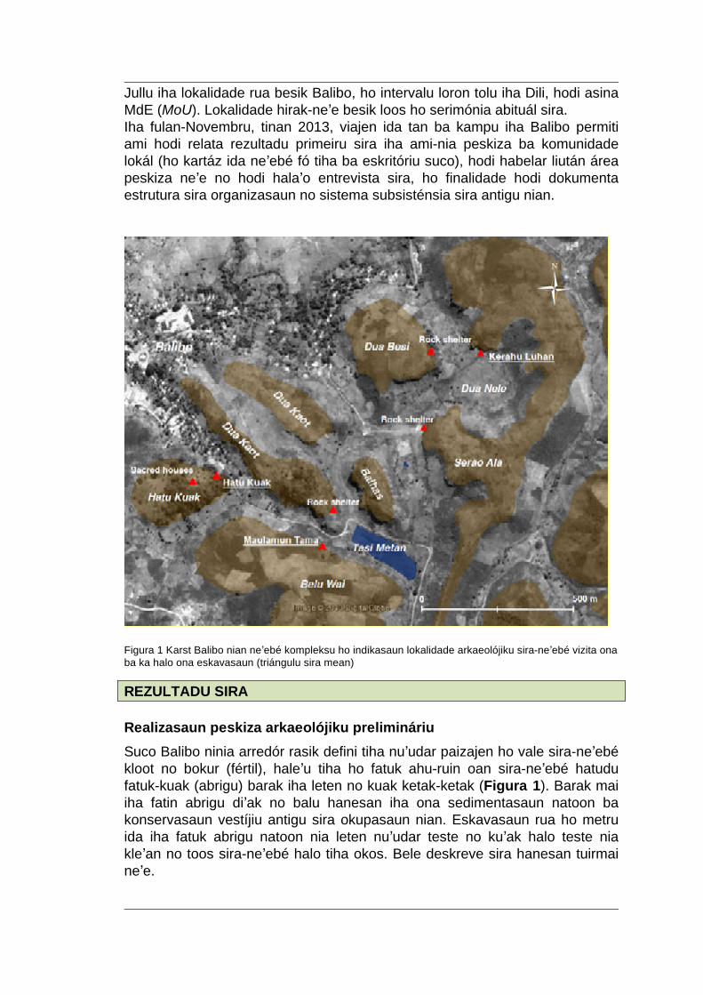
Figura 1 Karst Balibo nian neʼebé kompleksu ho indikasaun lokalidade arkaeolójiku sira-neʼebé vizita ona ba ka halo ona eskavasaun (triángulu sira mean)
REZULTADU SIRA Realizasaun peskiza arkaeolójiku prelimináriu Suco Balibo ninia arredór rasik defini tiha nuʼudar paizajen ho vale sira-neʼebé kloot no bokur (fértil), haleʼu tiha ho fatuk ahu-ruin oan sira-neʼebé hatudu fatuk-kuak (abrigu) barak iha leten no kuak ketak-ketak (Figura 1). Barak mai iha fatin abrigu diʼak no balu hanesan iha ona sedimentasaun natoon ba konservasaun vestíjiu antigu sira okupasaun nian. Eskavasaun rua ho metru ida iha fatuk abrigu natoon nia leten nuʼudar teste no kuʼak halo teste nia kleʼan no toos sira-neʼebé halo tiha okos. Bele deskreve sira hanesan tuirmai neʼe.
- 5 - - 5 --
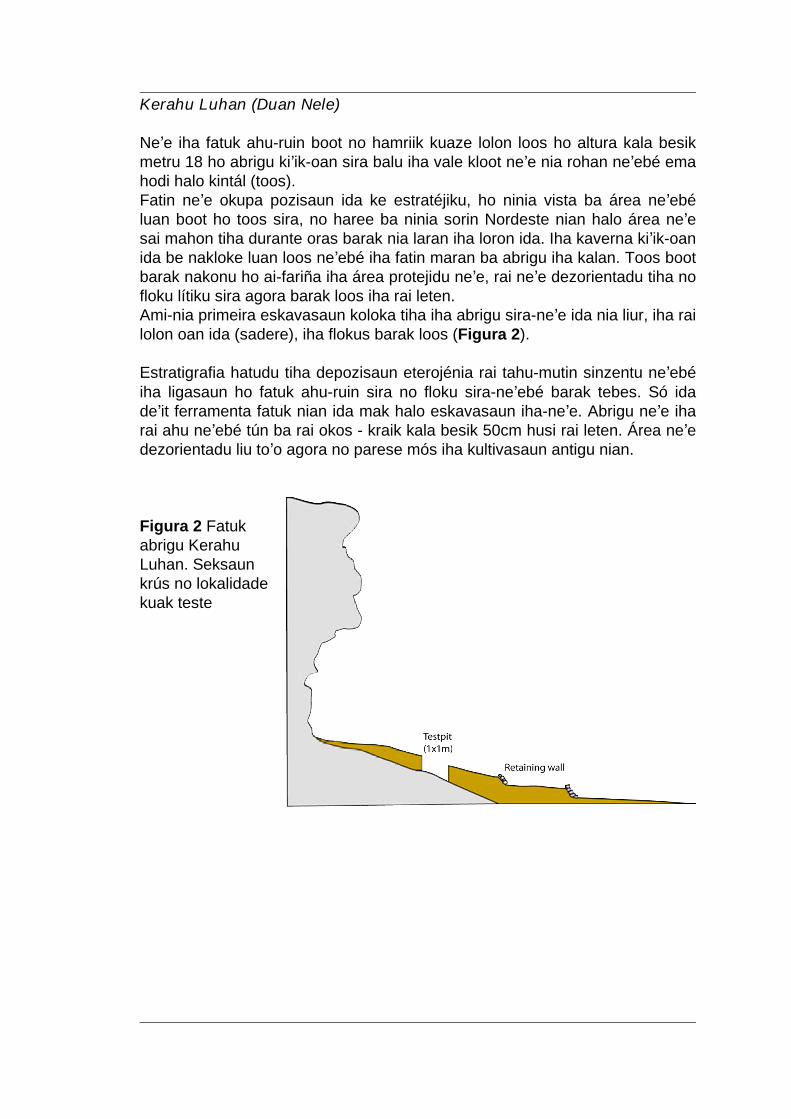
Kerahu Luhan (Duan Nele) Neʼe iha fatuk ahu-ruin boot no hamriik kuaze lolon loos ho altura kala besik metru 18 ho abrigu kiʼik-oan sira balu iha vale kloot neʼe nia rohan neʼebé ema hodi halo kintál (toos). Fatin neʼe okupa pozisaun ida ke estratéjiku, ho ninia vista ba área neʼebé luan boot ho toos sira, no haree ba ninia sorin Nordeste nian halo área neʼe sai mahon tiha durante oras barak nia laran iha loron ida. Iha kaverna kiʼik-oan ida be nakloke luan loos neʼebé iha fatin maran ba abrigu iha kalan. Toos boot barak nakonu ho ai-fariña iha área protejidu neʼe, rai neʼe dezorientadu tiha no floku lítiku sira agora barak loos iha rai leten. Ami-nia primeira eskavasaun koloka tiha iha abrigu sira-neʼe ida nia liur, iha rai lolon oan ida (sadere), iha flokus barak loos (Figura 2). Estratigrafia hatudu tiha depozisaun eterojénia rai tahu-mutin sinzentu neʼebé iha ligasaun ho fatuk ahu-ruin sira no floku sira-neʼebé barak tebes. Só ida deʼit ferramenta fatuk nian ida mak halo eskavasaun iha-neʼe. Abrigu neʼe iha rai ahu neʼebé tún ba rai okos - kraik kala besik 50cm husi rai leten. Área neʼe dezorientadu liu toʼo agora no parese mós iha kultivasaun antigu nian. Figura 2 Fatuk abrigu Kerahu Luhan. Seksaun krús no lokalidade kuak teste
- 6 - - 6 --
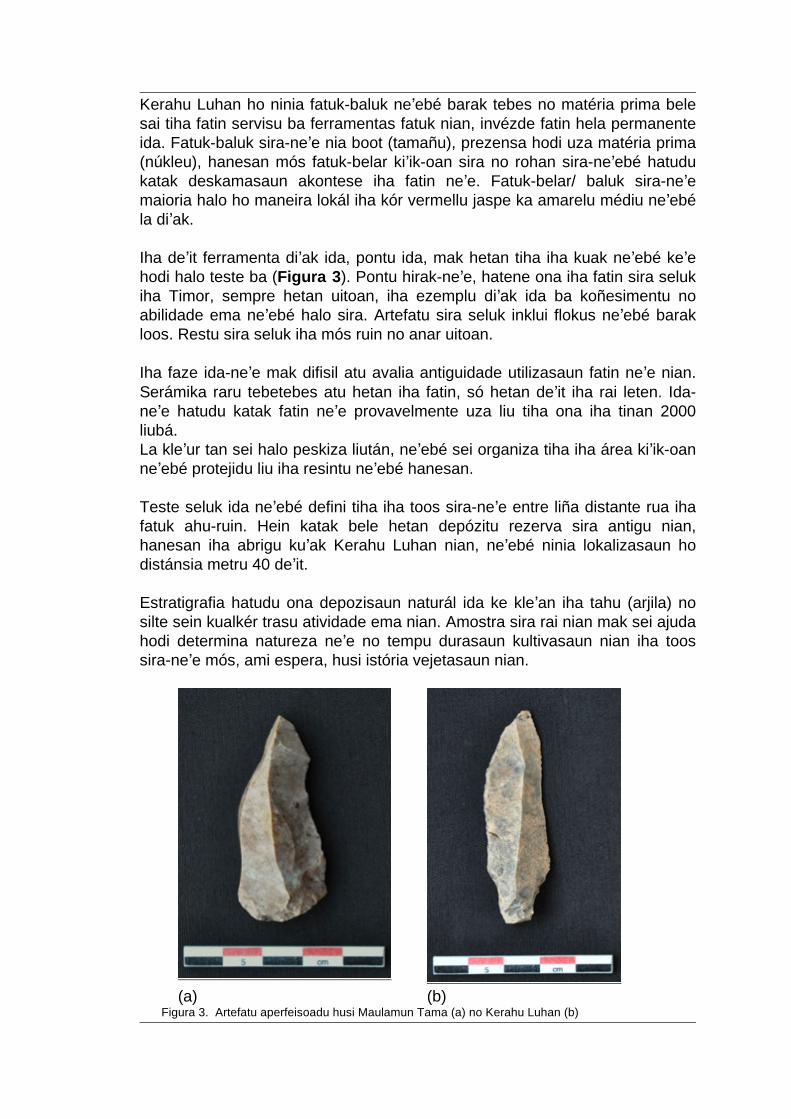
Kerahu Luhan ho ninia fatuk-baluk neʼebé barak tebes no matéria prima bele sai tiha fatin servisu ba ferramentas fatuk nian, invézde fatin hela permanente ida. Fatuk-baluk sira-neʼe nia boot (tamañu), prezensa hodi uza matéria prima (núkleu), hanesan mós fatuk-belar kiʼik-oan sira no rohan sira-neʼebé hatudu katak deskamasaun akontese iha fatin neʼe. Fatuk-belar/ baluk sira-neʼe maioria halo ho maneira lokál iha kór vermellu jaspe ka amarelu médiu neʼebé la diʼak. Iha deʼit ferramenta diʼak ida, pontu ida, mak hetan tiha iha kuak neʼebé keʼe hodi halo teste ba (Figura 3). Pontu hirak-neʼe, hatene ona iha fatin sira seluk iha Timor, sempre hetan uitoan, iha ezemplu diʼak ida ba koñesimentu no abilidade ema neʼebé halo sira. Artefatu sira seluk inklui flokus neʼebé barak loos. Restu sira seluk iha mós ruin no anar uitoan. Iha faze ida-neʼe mak difisil atu avalia antiguidade utilizasaun fatin neʼe nian. Serámika raru tebetebes atu hetan iha fatin, só hetan deʼit iha rai leten. Ida-neʼe hatudu katak fatin neʼe provavelmente uza liu tiha ona iha tinan 2000 liubá. La kleʼur tan sei halo peskiza liután, neʼebé sei organiza tiha iha área kiʼik-oan neʼebé protejidu liu iha resintu neʼebé hanesan. Teste seluk ida neʼebé defini tiha iha toos sira-neʼe entre liña distante rua iha fatuk ahu-ruin. Hein katak bele hetan depózitu rezerva sira antigu nian, hanesan iha abrigu kuʼak Kerahu Luhan nian, neʼebé ninia lokalizasaun ho distánsia metru 40 deʼit. Estratigrafia hatudu ona depozisaun naturál ida ke kleʼan iha tahu (arjila) no silte sein kualkér trasu atividade ema nian. Amostra sira rai nian mak sei ajuda hodi determina natureza neʼe no tempu durasaun kultivasaun nian iha toos sira-neʼe mós, ami espera, husi istória vejetasaun nian.
(a) (b)
Figura 3. Artefatu aperfeisoadu husi Maulamun Tama (a) no Kerahu Luhan (b)
- 7 - - 7 --
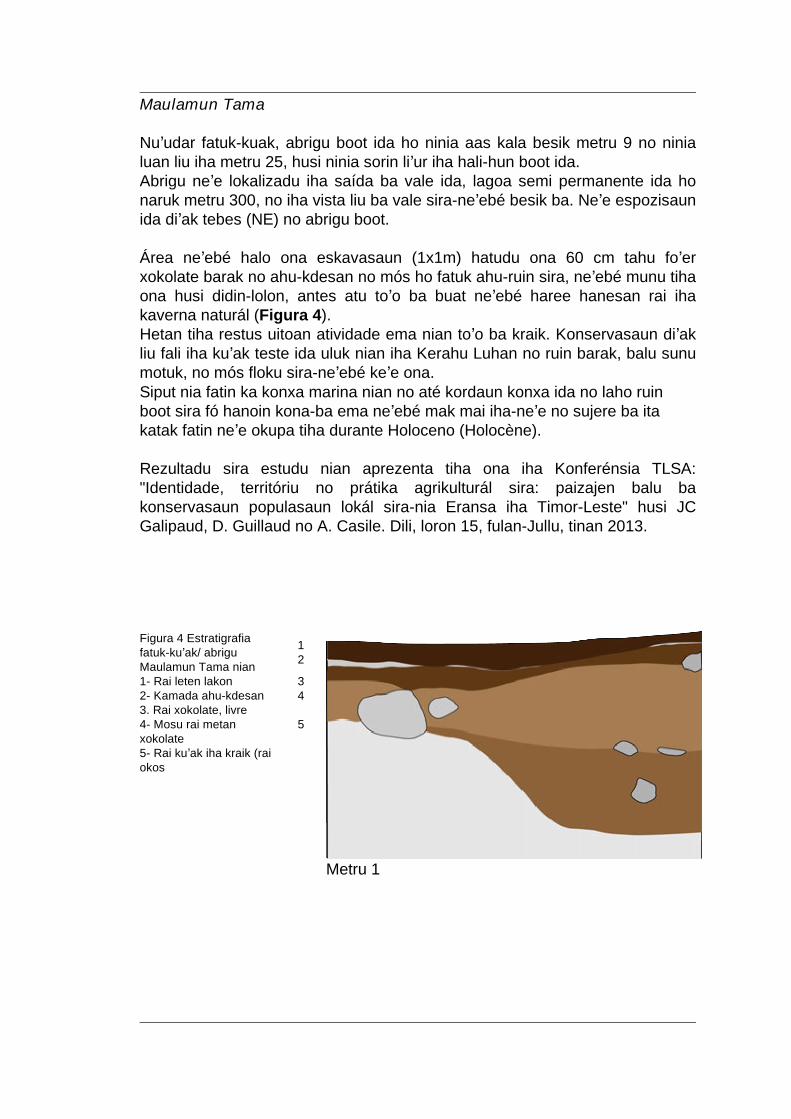
Maulamun Tama Nuʼudar fatuk-kuak, abrigu boot ida ho ninia aas kala besik metru 9 no ninia luan liu iha metru 25, husi ninia sorin liʼur iha hali-hun boot ida. Abrigu neʼe lokalizadu iha saída ba vale ida, lagoa semi permanente ida ho naruk metru 300, no iha vista liu ba vale sira-neʼebé besik ba. Neʼe espozisaun ida diʼak tebes (NE) no abrigu boot. Área neʼebé halo ona eskavasaun (1x1m) hatudu ona 60 cm tahu foʼer xokolate barak no ahu-kdesan no mós ho fatuk ahu-ruin sira, neʼebé munu tiha ona husi didin-lolon, antes atu toʼo ba buat neʼebé haree hanesan rai iha kaverna naturál (Figura 4). Hetan tiha restus uitoan atividade ema nian toʼo ba kraik. Konservasaun diʼak liu fali iha kuʼak teste ida uluk nian iha Kerahu Luhan no ruin barak, balu sunu motuk, no mós floku sira-neʼebé keʼe ona. Siput nia fatin ka konxa marina nian no até kordaun konxa ida no laho ruin boot sira fó hanoin kona-ba ema neʼebé mak mai iha-neʼe no sujere ba ita katak fatin neʼe okupa tiha durante Holoceno (Holocène). Rezultadu sira estudu nian aprezenta tiha ona iha Konferénsia TLSA: "Identidade, territóriu no prátika agrikulturál sira: paizajen balu ba konservasaun populasaun lokál sira-nia Eransa iha Timor-Leste" husi JC Galipaud, D. Guillaud no A. Casile. Dili, loron 15, fulan-Jullu, tinan 2013.
1 Figura 4 Estratigrafia
fatuk-kuʼak/ abrigu Maulamun Tama nian 2
1- Rai leten lakon 3 2- Kamada ahu-kdesan 4 3. Rai xokolate, livre 4- Mosu rai metan xokolate
5
5- Rai kuʼak iha kraik (rai okos
Metru 1
- 8 - - 8 --
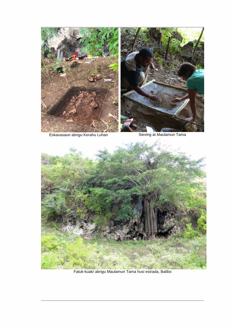
Eskavasaun abrigu Kerahu Luhan
Sieving at Maulamun Tama
Fatuk-kuak/ abrigu Maulamun Tama husi estrada, Balibo
- 9 - - 9 --
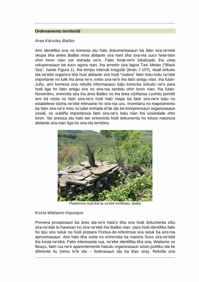
Ordenamentu territoriál Área Kárstiku Balibo Ami identifika ona no komesa atu halo dokumentasaun ba fatin sira-neʼebé okupa tiha antes Balibo ninia abitante sira harii tiha sira-nia suco hela-fatin ohin loron nian tuir estrada neʼe. Fatin hirak-neʼe lokalizadu iha vista rekuperasaun ba suco agora nian, iha arredór sira lagoa Tasi Metan (“Black Sea”, haree Figura 1). Iha tempu intervál irregulár (tinan 7-10?), rituál sirkuitu ida neʼebé organiza tiha husi abitante sira hodi “reativa” fatin hotu-hotu neʼebé importante no lulik iha área neʼe, entre sira-neʼe iha fatin antigu nian. Iha fulan-Juñu, ami komesa ona rekolla informasaun balu kona-ba sirkuitu neʼe para hodi liga ho fatin antigu sira no sira-nia sentidu ohin loron nian. Iha fulan-Novembru, entrevita sira iha área Balibo no iha área viziñansa Leohitu permiti ami bá vizita no fatin sira-neʼe hodi halo mapa ba fatin sira-neʼe balu no estabelese istória neʼebé relevante ho sira-nia uzu. Inventáriu no mapeamentu ba fatin sira-neʼe mós nuʼudar entrada diʼak ida ba komprensaun organizasaun sosiál, no subliña importánsia fatin sira-neʼe balu nian iha sosiedade ohin loron. Sei presiza atu halo tan entrevista hodi dokumenta ho loloos natureza abitante sira-nian liga ho sira-nia territóriu.
Plataforma rituál Baiʼas neʼebé fortifikadu, Balibo
Kosta Waitame-Viqueque Primeira prospesaun ba área ida-neʼe halaʼo tiha ona hodi dokumenta sítiu sira-neʼebé la hanesan ho sira-neʼebé iha Balibo nian, para hodi identifika fatin ho tipu sira seluk no hodi prepara Pontus-de-referénsia sira seluk ba ami-nia aproximasaun. Ami halo tiha vizita no entrevista ba maioria Suco sira-neʼebé iha kosta neʼebá. Fatin interesante rua, neʼebé identifika tiha ona, Waitame no Beaço, fatin rua neʼe aparentemente hatudu organizasaun sósio-polítiku ida ke diferente liu (reinu kiʼik ida – federasaun ida ba klan sira). Rekolla ona
- 10 - - 10 --
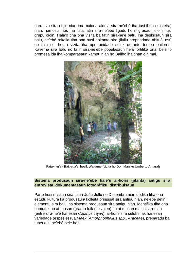
narrativu sira orijin nian iha maioria aldeia sira-neʼebé iha tasi-ibun (kosteira) nian, hamosu mós iha lista fatin sira-neʼebé ligadu ho migrasaun oioin husi grupu oioin. Halaʼo tiha ona vizita ba fatin sira-neʼe balu, iha deskrisaun sira balu, neʼebé rekolla tiha ona husi abitante sira (liuliu propriadade abituál nst) no sira sei hetan vizita iha oportunidade seluk durante tempu bailoron. Kaverna sira balu no fatin sira-neʼebé populasaun hela fortifika ona, bele fó promesa ida iha komparasaun kampu nian ho Balibo iha tinan oin mai.
Fatuk-kuʼak Baipagaʼsi besik Waitame (vizita ho Don Maniku Umberto Amaral)
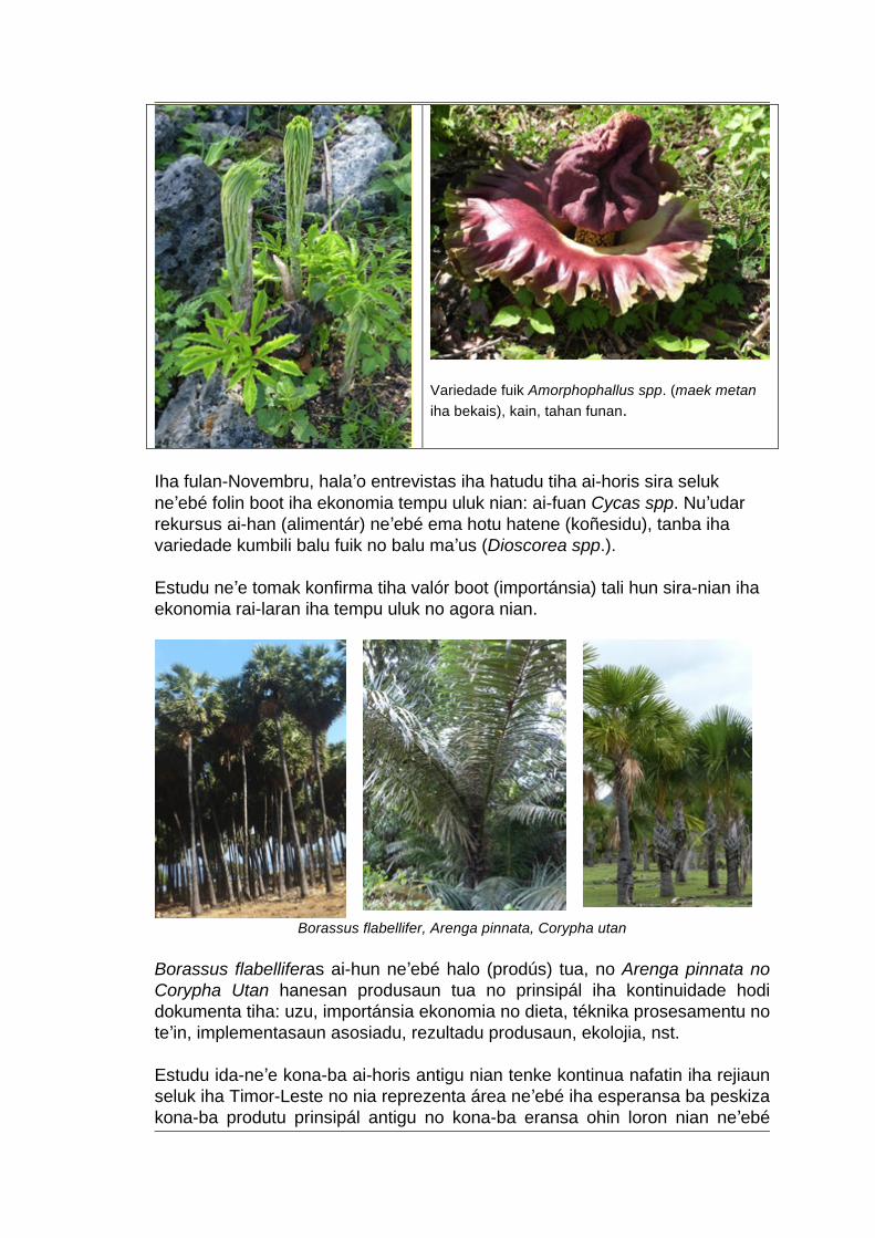
Sistema produsaun sira-neʼebé haleʼu ai-horis (planta) antigu sira: entrevista, dokumentasaun fotográfiku, distribuisaun Parte husi misaun sira fulan-Juñu-Jullu no Dezembru nian dedika tiha ona estudu kultura ka produsaun/ kolleita prinsipál sira antigu nian, neʼebé defini elementu sira balu iha sistema produsaun sira antigu nian. Identifika tiha ona hamutuk ho ai-musan (graun) fuik (selvajen) no ai-musan maʼus sira-nian (entre sira-neʼe hanesan Cajanus cajan), ai-horis sira seluk mak hanesan variedade (espésie) rua Maek (Amorphophallus spp., Araceae), preparadu ba tubérkulu neʼebé bele han.
- 11 - - 11 --
Variedade fuik Amorphophallus spp. (maek metan iha bekais), kain, tahan funan.
Iha fulan-Novembru, halaʼo entrevistas iha hatudu tiha ai-horis sira seluk neʼebé folin boot iha ekonomia tempu uluk nian: ai-fuan Cycas spp. Nuʼudar rekursus ai-han (alimentár) neʼebé ema hotu hatene (koñesidu), tanba iha variedade kumbili balu fuik no balu maʼus (Dioscorea spp.). Estudu neʼe tomak konfirma tiha valór boot (importánsia) tali hun sira-nian iha ekonomia rai-laran iha tempu uluk no agora nian.
Borassus flabellifer, Arenga pinnata, Corypha utan
Borassus flabelliferas ai-hun neʼebé halo (prodús) tua, no Arenga pinnata no Corypha Utan hanesan produsaun tua no prinsipál iha kontinuidade hodi dokumenta tiha: uzu, importánsia ekonomia no dieta, téknika prosesamentu no teʼin, implementasaun asosiadu, rezultadu produsaun, ekolojia, nst. Estudu ida-neʼe kona-ba ai-horis antigu nian tenke kontinua nafatin iha rejiaun seluk iha Timor-Leste no nia reprezenta área neʼebé iha esperansa ba peskiza kona-ba produtu prinsipál antigu no kona-ba eransa ohin loron nian neʼebé
- 12 - - 12 --
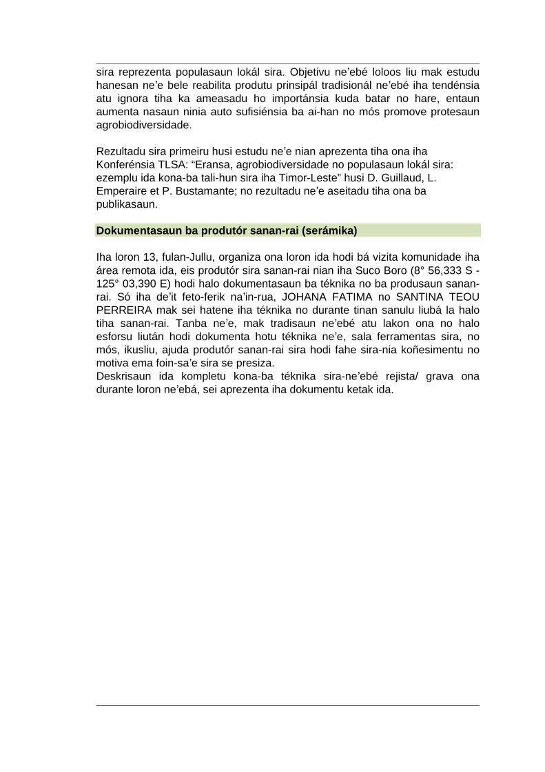
sira reprezenta populasaun lokál sira. Objetivu neʼebé loloos liu mak estudu hanesan neʼe bele reabilita produtu prinsipál tradisionál neʼebé iha tendénsia atu ignora tiha ka ameasadu ho importánsia kuda batar no hare, entaun aumenta nasaun ninia auto sufisiénsia ba ai-han no mós promove protesaun agrobiodiversidade. Rezultadu sira primeiru husi estudu neʼe nian aprezenta tiha ona iha Konferénsia TLSA: “Eransa, agrobiodiversidade no populasaun lokál sira: ezemplu ida kona-ba tali-hun sira iha Timor-Leste” husi D. Guillaud, L. Emperaire et P. Bustamante; no rezultadu neʼe aseitadu tiha ona ba publikasaun. Dokumentasaun ba produtór sanan-rai (serámika) Iha loron 13, fulan-Jullu, organiza ona loron ida hodi bá vizita komunidade iha área remota ida, eis produtór sira sanan-rai nian iha Suco Boro (8° 56,333 S - 125° 03,390 E) hodi halo dokumentasaun ba téknika no ba produsaun sanan-rai. Só iha deʼit feto-ferik naʼin-rua, JOHANA FATIMA no SANTINA TEOU PERREIRA mak sei hatene iha téknika no durante tinan sanulu liubá la halo tiha sanan-rai. Tanba neʼe, mak tradisaun neʼebé atu lakon ona no halo esforsu liután hodi dokumenta hotu téknika neʼe, sala ferramentas sira, no mós, ikusliu, ajuda produtór sanan-rai sira hodi fahe sira-nia koñesimentu no motiva ema foin-saʼe sira se presiza. Deskrisaun ida kompletu kona-ba téknika sira-neʼebé rejista/ grava ona durante loron neʼebá, sei aprezenta iha dokumentu ketak ida.
- 13 - - 13 --
Ema sira halo sanan-rai (serámika) Suco Boro prepara daudaun tahu (rai-mean) PESKIZA TUIRMAI Haree hanesan sei iha kondisaun sira hotu hodi lansa peskiza ida kona-ba agrobiodiversidade nian neʼebé enkuadra iha programa neʼebé luan liu kona-ba istória okupasaun ema nian iha Timor-Leste. Kestaun prinsipál mak konservasaun rekursus vejetasaun nian neʼebé inklui iha sistema produsaun sira-nian, konsidera ba mekanizmu ka maneira oinsá mak populasaun lokál sira sei halo jestaun ba rekursus hirak-neʼe, husi espontáneu ba kultivadu (ho énfaze ida ba Corypha no Borassuspalmsandwild no Fabaceae-Cajanus, Amorphophallus kultivadu, haree). Membru ekipa Paloc nian seluk bele envolve mak hanesan Laure Emperaire no Patricia Bustamante. Eskavasaun sira-neʼe sei kontinua halaʼo nafatin iha rejiaun Balibo nian iha fatuk-kuʼak/ abrigu sira-neʼebé halo tiha ona teste ba (Kerahu Luhan no Maulamun Tama) no sei kobre toʼo área karst nian ba Suco Ferik Katuas. Levantamentu/ peskiza adisionál sira iha área kosteira rejiaun Viqueque no iha illa Ataúro sei organiza iha tinan 2014 hodi buka atu identifika okupasaun espasu nakloke iha tempu tinan 4000 liubá. Área kosteira hirak-neʼe, raru iha Timor-Leste durante neʼe no se identifika ona, sei ajuda atu komprendewill help understand the developpment and changes in the economy of subsistence during the later part of the island's history.
- 14 - - 14 --
Servisu kolaborativu ida halaʼo daudaun hodi klasifika (karateriza) ambiente naturál sira no fauna iha tempu uluk nian iha rejiaun sira Balibo, Viqueque no mós illa Ataúro, no hodi defini impaktu ema nian no utilizasaun rekursus naturais iha pasadu. Kolaborasaun ida-neʼe sei envolve instituisaun balu no peskizadór no liuliu: - Muzeu Istória Nasionál iha Paris, Fransa ba análize ferramenta fatuk, identifikasaun faunál no botániku. - Institutu Français de Pondichery iha India ba estudu ambiente naturál pasadu nian (phytoliths, pollens) no mós espesialista sira iha fauna antigu rejiaun nian (Anthracologie, identifikasaun faunál,...) Enkontru ida, neʼebé Aurélie Seguin organiza ho ONG Timor Aid mós loke área interesante ida iha kooperasaun ba reabilitasaun elementu sira balu kultura ema Timoroan sira-nian, liuhusi publikasaun livru sira kona-ba arkeolojia nian, ba ai-horis (planta) antigun sira Timor nian, nst. Liafuan Agradesimentu Viajen ba kampu neʼe bele halaʼo tiha liuhusi finansiamentu UMR Paloc IRD-MNHN nian iha Paris no departamentu servisu kulturál Embaixada Fransa nian iha Jakarta. Autorizasaun sira ba estudu/ peskiza nian neʼebé hetan tiha ona husi Sekretáriu Estadu ba Arte no Kultura, Ministériu Turizmu nian, no ami hakarak hatoʼo obrigadu ba Sra Cecilia Assis, no M Nuno Oliveira ba sira-nia apoiu neʼebé diʼak. Iha kampu, ami agradese tebes ba funsionáriu sira Sekretaria Estadu ba Kultura nian (liuliu Sra Maria Verdial), ba Xefe-Suco Balibo, autoridade rejionál no provinsiál sira, ba populasaun (abitantes) Balibo nian no mós ba informante sira hotu iha Balibo no rejiaun Viqueque, neʼebé sai tiha ami-nia matadalan ba fatin (sítiu) sira neʼe no fahe tiha sira-nia koñesimentu mai ami.
- 2 - - 2 --
Foreword (reminder of 2012 preliminary report) East Timor lies at the threshold between insular Southeast Asia and Oceania. At the easternmost tip of the Sunda chain of islands, and off Australia's North coast, it presents an original combination between Austronesian and Papuan worlds, and both linguistic groups coexist within the country. Recent political events have disrupted local identities and cultures and present-day national policies insist on the necessity of their rehabilitation. This aim coincides with a partly unanswered scientific question about the encounters and adaptations of Austronesians to the Papuan world. Some elements seem crucial to understand the relationships of Timorese to their land: a study of local visions of the landscape and the territory is needed in order to spot out which places or “geosymbols” invested with history, myth, magic or power are significant for the local populations. These places highlight the primary elements of the endogenous territories, such as sacred places to be protected, archaeological sites to be surveyed, various resources, etc., and inform on the local group(s) to whom they resort. The agricultural systems, including the knowledge associated to them, are inscribed in the local territories organised around their sacred cores. All theses elements, sites, places, systems and knowledge are the prime elements of East Timor's heritage and must be understood, protected and valued. They can provide the landmarks for a policy of promotion and protection of national heritage in some parts of the country. This approach can also contribute to the conception of a regional cultural Centre, which is one of the envisioned outcomes of present-day national policies. The aims of the project are: •To establish the chronological framework of human occupation in the area chosen for the project. •To locate places, sites, knowledge, history and other elements that are significant for the populations' identity and land-rights, and identify potential threats on them. •To spot and discuss which elements can be considered as having a potential for heritage (ie elements invested with a specific or symbolic value, which are collectively managed to be transmitted to future generations); •To set up a method for the understanding of local communities' representations of territory, land, places, environment, and also of their past, and •To take part in the training of selected fieldworkers in order to fulfil the inventory, presentation and valuation of national heritage and facilitate exchange with heritage management projects in other countries. From September 25 to October 12, 2012, a first survey of potential area has been undertaken, in order to determine the detailed zone of research and identify potential informers. One of the regions spotted for further investigation was the Balibo karst area, where the village authorities had been informed of
- 2 - - 2 --
our forthcoming in June 2013. Another field trip has been undertaken in November, 2013. Objectives of the 2013 mission - To identify and excavate relevant archaeological sites, in order to establish a chronology of settlement and land-use; to determine the environments associated with ancient occupations. - To analyse present-day territorial organisation, and the link with archaeological and historical elements. - To document some possible elements of ancient subsistence systems. - To disseminate the first results of this fieldwork at TLSA conference in Dili.
The signing of the MoU between the Secretaria de Estado da Cultura and IRD was planned to coincide with this mission, with the arrival of Jean-Paul Toutain, the IRD representative in Indonesia and Timor Leste, on the 8th of July. Itinerary 23-25 June Contacts in Dili : - Secretaria de Estado da Cultura: Cecilia Assis & Nuno Oliveira 26 June – 8 July Balibo field trip 10 July Signature of MoU between the Secretaria de Estado da Cultura and IRD in Dili 11 July – 14 July Balibo field trip 15-17 July TLSA Conference, Dili 25-30 November Field trip Balibo, Leuhitu, Maliana 2-9 December Field trip to the Viqueque region 10-11 December Dili; meeting with Aurélie Seguin, and Timor Aid
- 3 - - 3 --
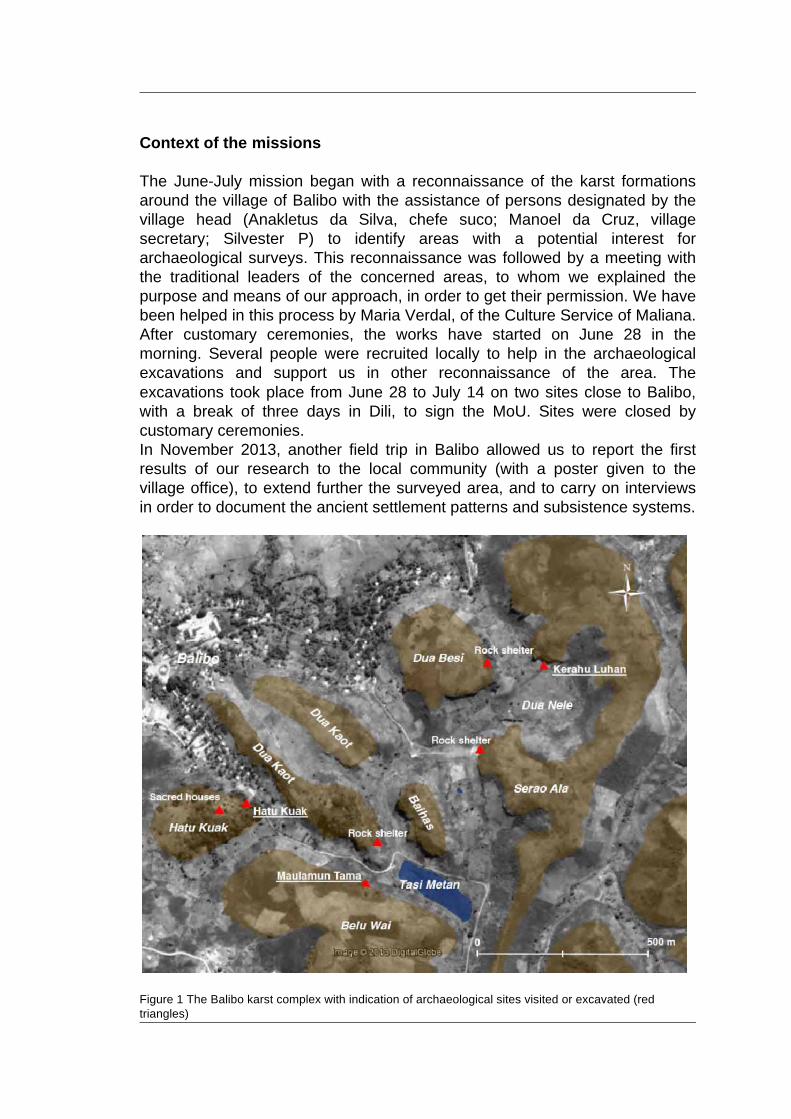
Context of the missions The June-July mission began with a reconnaissance of the karst formations around the village of Balibo with the assistance of persons designated by the village head (Anakletus da Silva, chefe suco; Manoel da Cruz, village secretary; Silvester P) to identify areas with a potential interest for archaeological surveys. This reconnaissance was followed by a meeting with the traditional leaders of the concerned areas, to whom we explained the purpose and means of our approach, in order to get their permission. We have been helped in this process by Maria Verdal, of the Culture Service of Maliana. After customary ceremonies, the works have started on June 28 in the morning. Several people were recruited locally to help in the archaeological excavations and support us in other reconnaissance of the area. The excavations took place from June 28 to July 14 on two sites close to Balibo, with a break of three days in Dili, to sign the MoU. Sites were closed by customary ceremonies. In November 2013, another field trip in Balibo allowed us to report the first results of our research to the local community (with a poster given to the village office), to extend further the surveyed area, and to carry on interviews in order to document the ancient settlement patterns and subsistence systems.
Figure 1 The Balibo karst complex with indication of archaeological sites visited or excavated (red triangles)
- 4 - - 4 --
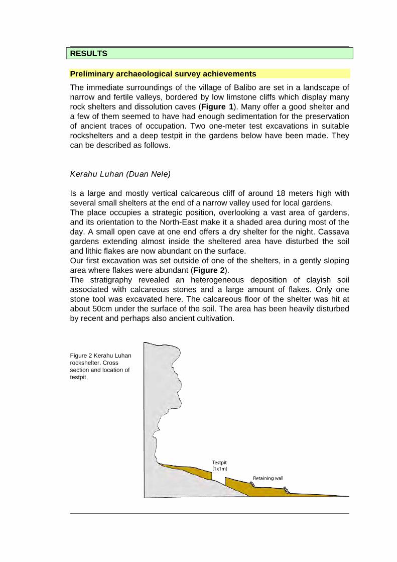
RESULTS Preliminary archaeological survey achievements The immediate surroundings of the village of Balibo are set in a landscape of narrow and fertile valleys, bordered by low limstone cliffs which display many rock shelters and dissolution caves (Figure 1). Many offer a good shelter and a few of them seemed to have had enough sedimentation for the preservation of ancient traces of occupation. Two one-meter test excavations in suitable rockshelters and a deep testpit in the gardens below have been made. They can be described as follows. Kerahu Luhan (Duan Nele) Is a large and mostly vertical calcareous cliff of around 18 meters high with several small shelters at the end of a narrow valley used for local gardens. The place occupies a strategic position, overlooking a vast area of gardens, and its orientation to the North-East make it a shaded area during most of the day. A small open cave at one end offers a dry shelter for the night. Cassava gardens extending almost inside the sheltered area have disturbed the soil and lithic flakes are now abundant on the surface. Our first excavation was set outside of one of the shelters, in a gently sloping area where flakes were abundant (Figure 2). The stratigraphy revealed an heterogeneous deposition of clayish soil associated with calcareous stones and a large amount of flakes. Only one stone tool was excavated here. The calcareous floor of the shelter was hit at about 50cm under the surface of the soil. The area has been heavily disturbed by recent and perhaps also ancient cultivation. Figure 2 Kerahu Luhan rockshelter. Cross section and location of testpit
- 5 - - 5 --
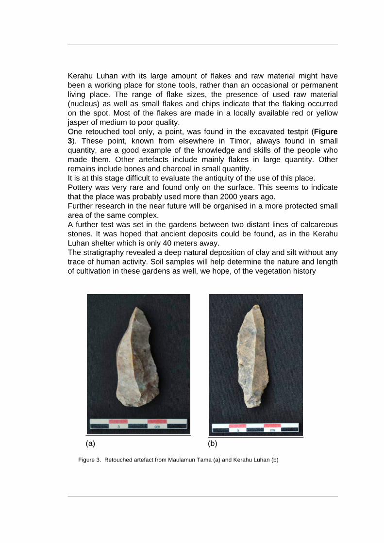
Kerahu Luhan with its large amount of flakes and raw material might have been a working place for stone tools, rather than an occasional or permanent living place. The range of flake sizes, the presence of used raw material (nucleus) as well as small flakes and chips indicate that the flaking occurred on the spot. Most of the flakes are made in a locally available red or yellow jasper of medium to poor quality. One retouched tool only, a point, was found in the excavated testpit (Figure 3). These point, known from elsewhere in Timor, always found in small quantity, are a good example of the knowledge and skills of the people who made them. Other artefacts include mainly flakes in large quantity. Other remains include bones and charcoal in small quantity. It is at this stage difficult to evaluate the antiquity of the use of this place. Pottery was very rare and found only on the surface. This seems to indicate that the place was probably used more than 2000 years ago. Further research in the near future will be organised in a more protected small area of the same complex. A further test was set in the gardens between two distant lines of calcareous stones. It was hoped that ancient deposits could be found, as in the Kerahu Luhan shelter which is only 40 meters away. The stratigraphy revealed a deep natural deposition of clay and silt without any trace of human activity. Soil samples will help determine the nature and length of cultivation in these gardens as well, we hope, of the vegetation history
(a) (b)
Figure 3. Retouched artefact from Maulamun Tama (a) and Kerahu Luhan (b)
- 6 - - 6 --
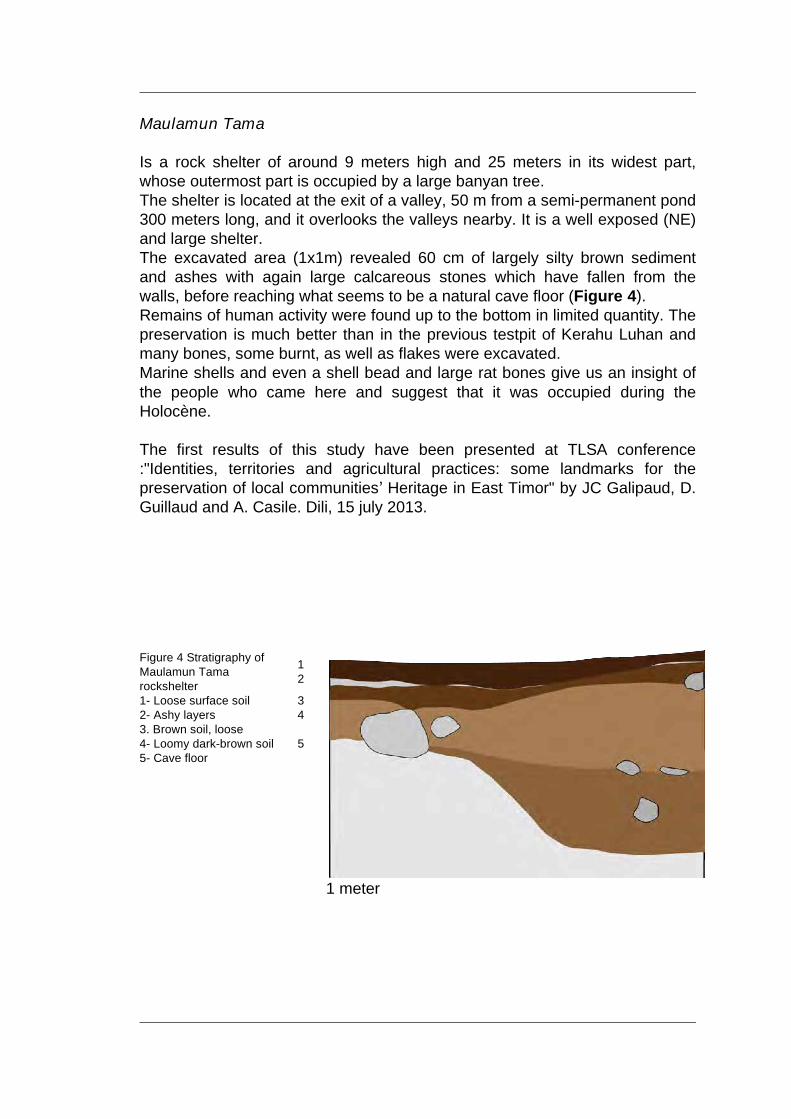
Maulamun Tama Is a rock shelter of around 9 meters high and 25 meters in its widest part, whose outermost part is occupied by a large banyan tree. The shelter is located at the exit of a valley, 50 m from a semi-permanent pond 300 meters long, and it overlooks the valleys nearby. It is a well exposed (NE) and large shelter. The excavated area (1x1m) revealed 60 cm of largely silty brown sediment and ashes with again large calcareous stones which have fallen from the walls, before reaching what seems to be a natural cave floor (Figure 4). Remains of human activity were found up to the bottom in limited quantity. The preservation is much better than in the previous testpit of Kerahu Luhan and many bones, some burnt, as well as flakes were excavated. Marine shells and even a shell bead and large rat bones give us an insight of the people who came here and suggest that it was occupied during the Holocène. The first results of this study have been presented at TLSA conference :"Identities, territories and agricultural practices: some landmarks for the preservation of local communitiesʼ Heritage in East Timor" by JC Galipaud, D. Guillaud and A. Casile. Dili, 15 july 2013.
1 Figure 4 Stratigraphy of
Maulamun Tama rockshelter 2
1- Loose surface soil 3 2- Ashy layers 4 3. Brown soil, loose 4- Loomy dark-brown soil 5 5- Cave floor
1 meter
- 7 - - 7 --
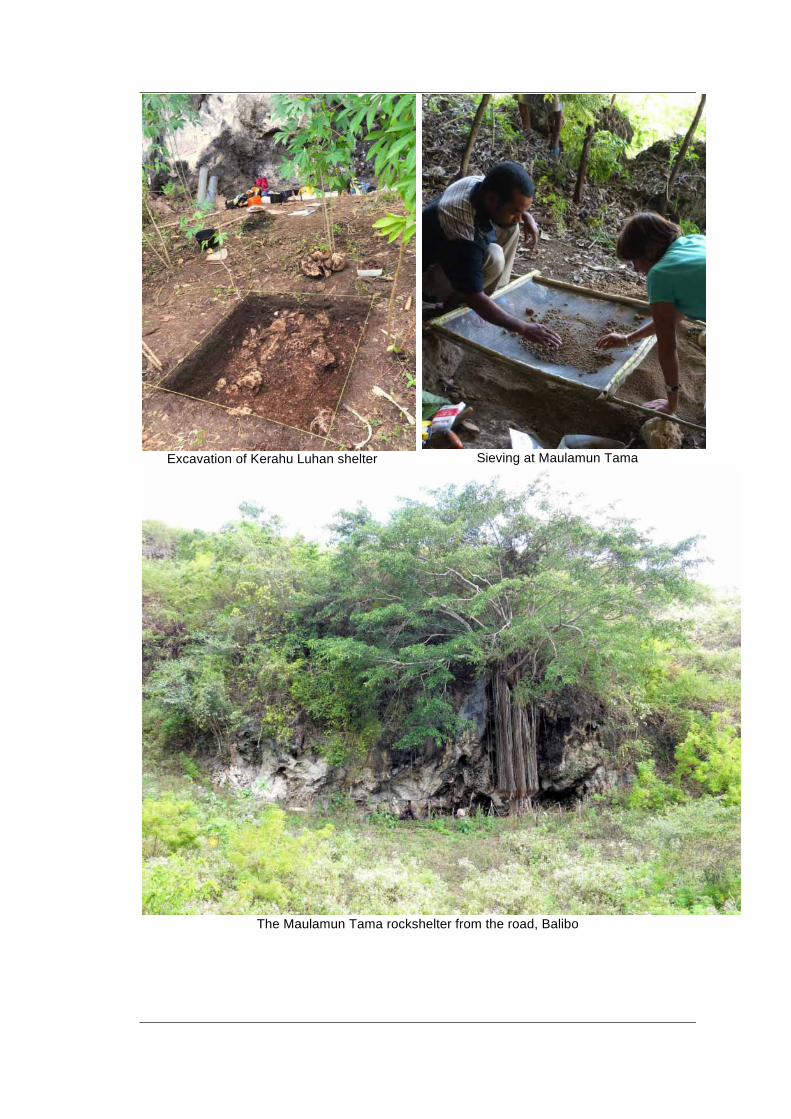
Excavation of Kerahu Luhan shelter Sieving at Maulamun Tama
The Maulamun Tama rockshelter from the road, Balibo
- 8 - - 8 --
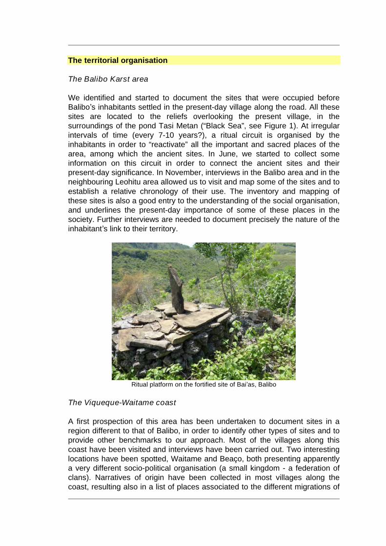
The territorial organisation The Balibo Karst area We identified and started to document the sites that were occupied before Baliboʼs inhabitants settled in the present-day village along the road. All these sites are located to the reliefs overlooking the present village, in the surroundings of the pond Tasi Metan (“Black Sea”, see Figure 1). At irregular intervals of time (every 7-10 years?), a ritual circuit is organised by the inhabitants in order to “reactivate” all the important and sacred places of the area, among which the ancient sites. In June, we started to collect some information on this circuit in order to connect the ancient sites and their present-day significance. In November, interviews in the Balibo area and in the neighbouring Leohitu area allowed us to visit and map some of the sites and to establish a relative chronology of their use. The inventory and mapping of these sites is also a good entry to the understanding of the social organisation, and underlines the present-day importance of some of these places in the society. Further interviews are needed to document precisely the nature of the inhabitantʼs link to their territory.
Ritual platform on the fortified site of Baiʼas, Balibo
The Viqueque-Waitame coast A first prospection of this area has been undertaken to document sites in a region different to that of Balibo, in order to identify other types of sites and to provide other benchmarks to our approach. Most of the villages along this coast have been visited and interviews have been carried out. Two interesting locations have been spotted, Waitame and Beaço, both presenting apparently a very different socio-political organisation (a small kingdom - a federation of clans). Narratives of origin have been collected in most villages along the coast, resulting also in a list of places associated to the different migrations of
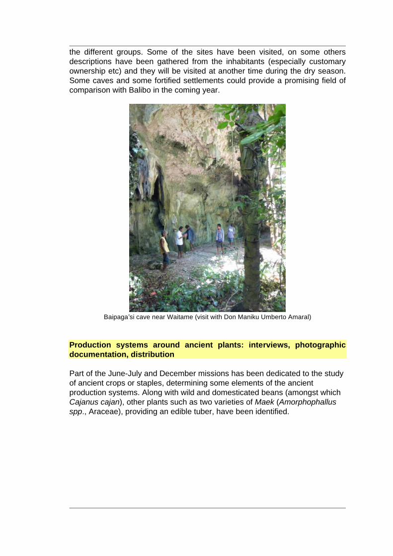
- 9 - - 9 --
the different groups. Some of the sites have been visited, on some others descriptions have been gathered from the inhabitants (especially customary ownership etc) and they will be visited at another time during the dry season. Some caves and some fortified settlements could provide a promising field of comparison with Balibo in the coming year.
Baipagaʼsi cave near Waitame (visit with Don Maniku Umberto Amaral)
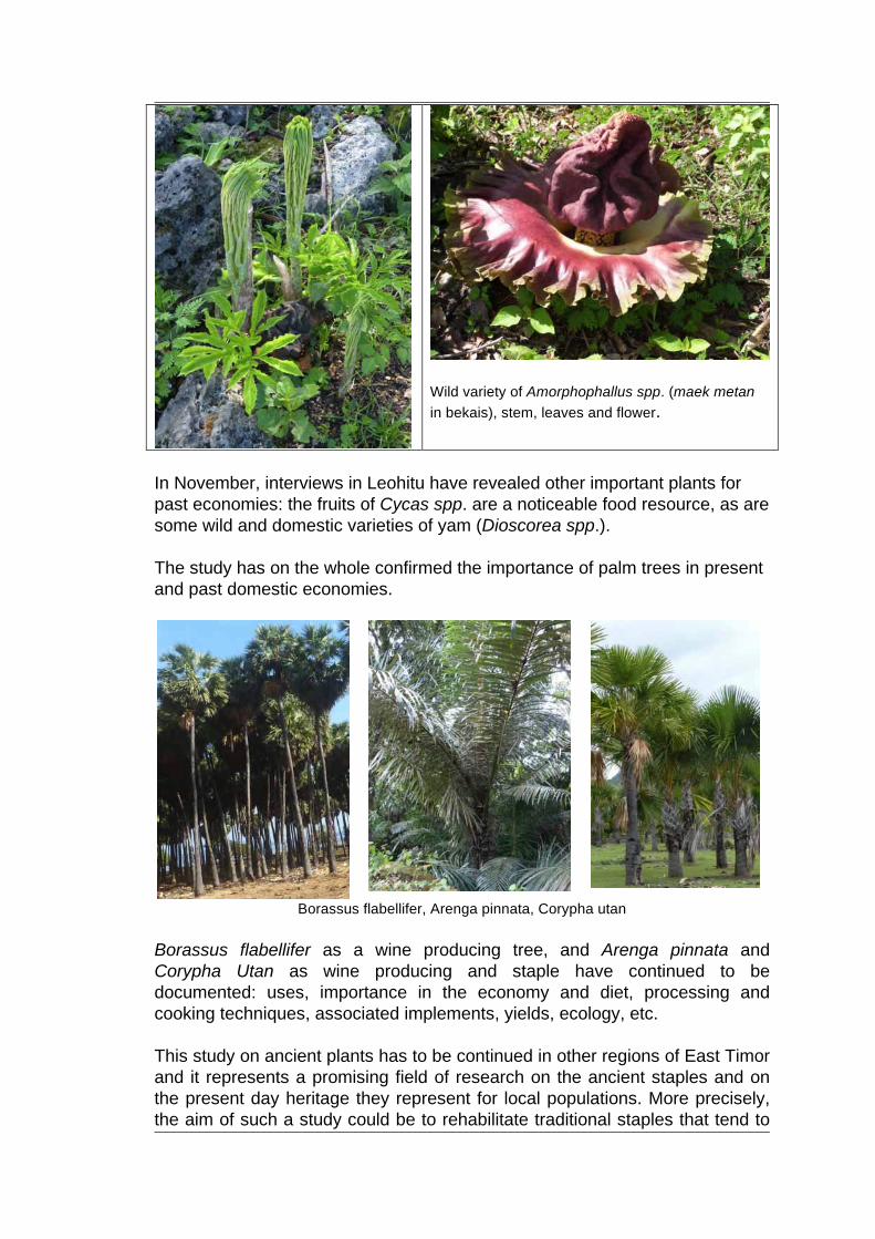
Production systems around ancient plants: interviews, photographic documentation, distribution Part of the June-July and December missions has been dedicated to the study of ancient crops or staples, determining some elements of the ancient production systems. Along with wild and domesticated beans (amongst which Cajanus cajan), other plants such as two varieties of Maek (Amorphophallus spp., Araceae), providing an edible tuber, have been identified.
- 10 - - 10 --
Wild variety of Amorphophallus spp. (maek metan in bekais), stem, leaves and flower.
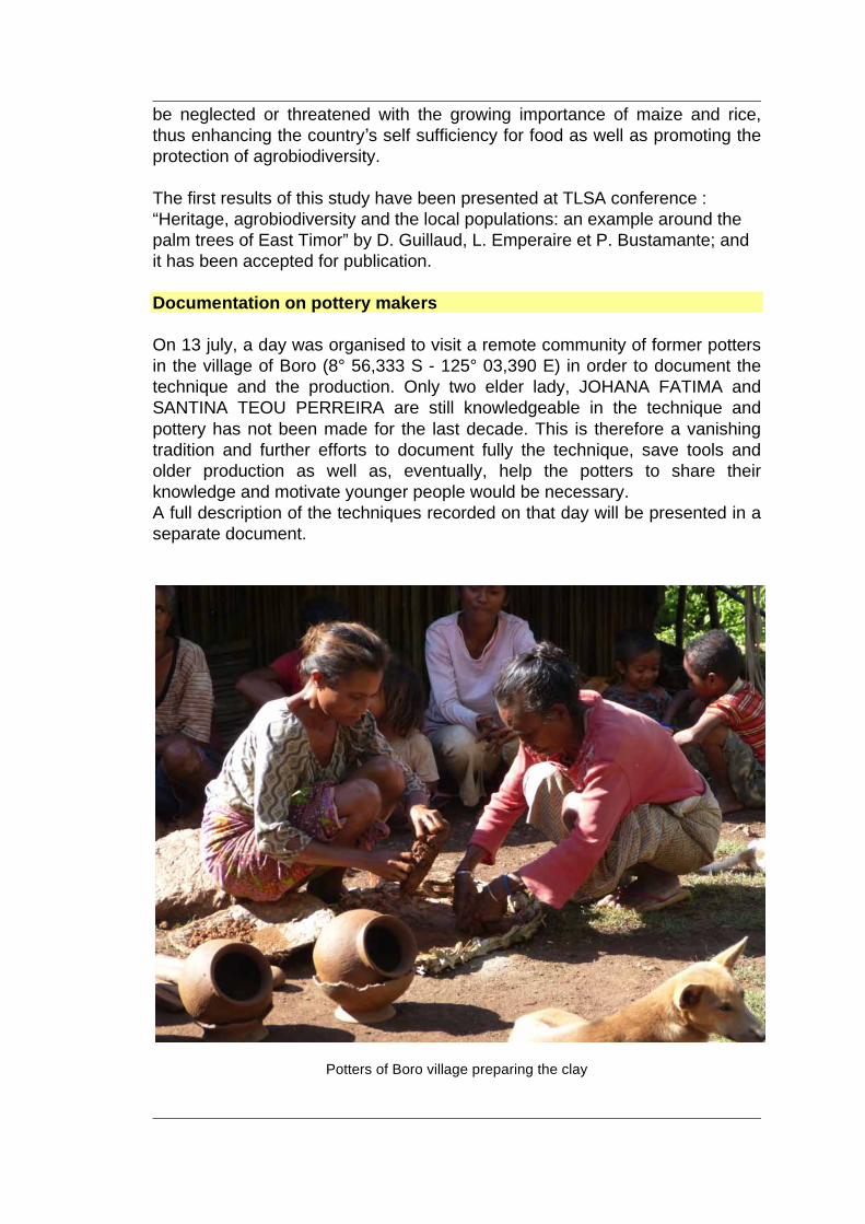
In November, interviews in Leohitu have revealed other important plants for past economies: the fruits of Cycas spp. are a noticeable food resource, as are some wild and domestic varieties of yam (Dioscorea spp.). The study has on the whole confirmed the importance of palm trees in present and past domestic economies.
Borassus flabellifer, Arenga pinnata, Corypha utan
Borassus flabellifer as a wine producing tree, and Arenga pinnata and Corypha Utan as wine producing and staple have continued to be documented: uses, importance in the economy and diet, processing and cooking techniques, associated implements, yields, ecology, etc. This study on ancient plants has to be continued in other regions of East Timor and it represents a promising field of research on the ancient staples and on the present day heritage they represent for local populations. More precisely, the aim of such a study could be to rehabilitate traditional staples that tend to
- 11 - - 11 --
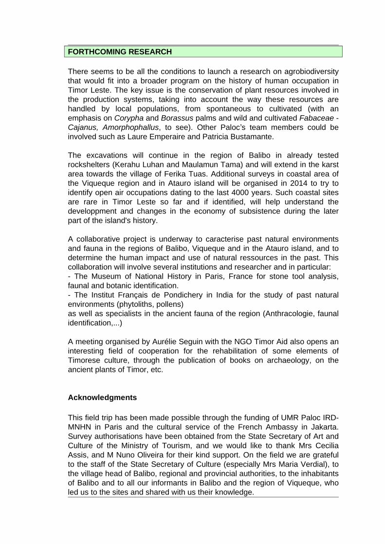
be neglected or threatened with the growing importance of maize and rice, thus enhancing the countryʼs self sufficiency for food as well as promoting the protection of agrobiodiversity. The first results of this study have been presented at TLSA conference : “Heritage, agrobiodiversity and the local populations: an example around the palm trees of East Timor” by D. Guillaud, L. Emperaire et P. Bustamante; and it has been accepted for publication. Documentation on pottery makers On 13 july, a day was organised to visit a remote community of former potters in the village of Boro (8° 56,333 S - 125° 03,390 E) in order to document the technique and the production. Only two elder lady, JOHANA FATIMA and SANTINA TEOU PERREIRA are still knowledgeable in the technique and pottery has not been made for the last decade. This is therefore a vanishing tradition and further efforts to document fully the technique, save tools and older production as well as, eventually, help the potters to share their knowledge and motivate younger people would be necessary. A full description of the techniques recorded on that day will be presented in a separate document.
Potters of Boro village preparing the clay
- 12 - - 12 --
FORTHCOMING RESEARCH There seems to be all the conditions to launch a research on agrobiodiversity that would fit into a broader program on the history of human occupation in Timor Leste. The key issue is the conservation of plant resources involved in the production systems, taking into account the way these resources are handled by local populations, from spontaneous to cultivated (with an emphasis on Corypha and Borassus palms and wild and cultivated Fabaceae - Cajanus, Amorphophallus, to see). Other Palocʼs team members could be involved such as Laure Emperaire and Patricia Bustamante. The excavations will continue in the region of Balibo in already tested rockshelters (Kerahu Luhan and Maulamun Tama) and will extend in the karst area towards the village of Ferika Tuas. Additional surveys in coastal area of the Viqueque region and in Atauro island will be organised in 2014 to try to identify open air occupations dating to the last 4000 years. Such coastal sites are rare in Timor Leste so far and if identified, will help understand the developpment and changes in the economy of subsistence during the later part of the island's history. A collaborative project is underway to caracterise past natural environments and fauna in the regions of Balibo, Viqueque and in the Atauro island, and to determine the human impact and use of natural ressources in the past. This collaboration will involve several institutions and researcher and in particular: - The Museum of National History in Paris, France for stone tool analysis, faunal and botanic identification. - The Institut Français de Pondichery in India for the study of past natural environments (phytoliths, pollens) as well as specialists in the ancient fauna of the region (Anthracologie, faunal identification,...) A meeting organised by Aurélie Seguin with the NGO Timor Aid also opens an interesting field of cooperation for the rehabilitation of some elements of Timorese culture, through the publication of books on archaeology, on the ancient plants of Timor, etc. Acknowledgments This field trip has been made possible through the funding of UMR Paloc IRD-MNHN in Paris and the cultural service of the French Ambassy in Jakarta. Survey authorisations have been obtained from the State Secretary of Art and Culture of the Ministry of Tourism, and we would like to thank Mrs Cecilia Assis, and M Nuno Oliveira for their kind support. On the field we are grateful to the staff of the State Secretary of Culture (especially Mrs Maria Verdial), to the village head of Balibo, regional and provincial authorities, to the inhabitants of Balibo and to all our informants in Balibo and the region of Viqueque, who led us to the sites and shared with us their knowledge.
- 13 - - 13 --
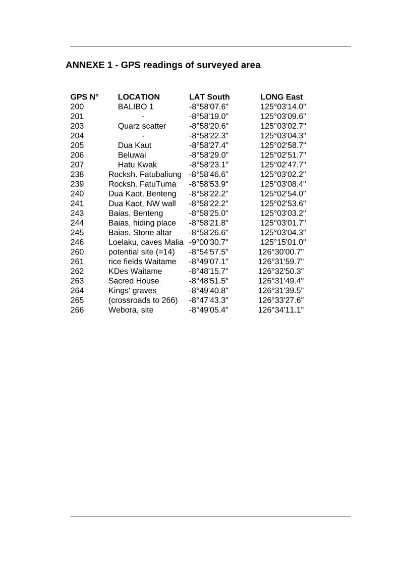
ANNEXE 1 - GPS readings of surveyed area
GPS N° LOCATION LAT South LONG East 200 BALIBO 1 -8°58'07.6" 125°03'14.0" 201 - -8°58'19.0" 125°03'09.6" 203 Quarz scatter -8°58'20.6" 125°03'02.7" 204 - -8°58'22.3" 125°03'04.3" 205 Dua Kaut -8°58'27.4" 125°02'58.7" 206 Beluwai -8°58'29.0" 125°02'51.7" 207 Hatu Kwak -8°58'23.1" 125°02'47.7" 238 Rocksh. Fatubaliung -8°58'46.6" 125°03'02.2" 239 Rocksh. FatuTuma -8°58'53.9" 125°03'08.4" 240 Dua Kaot, Benteng -8°58'22.2" 125°02'54.0" 241 Dua Kaot, NW wall -8°58'22.2" 125°02'53.6" 243 Baias, Benteng -8°58'25.0" 125°03'03.2" 244 Baias, hiding place -8°58'21.8" 125°03'01.7" 245 Baias, Stone altar -8°58'26.6" 125°03'04.3" 246 Loelaku, caves Malia -9°00'30.7" 125°15'01.0" 260 potential site (=14) -8°54'57.5" 126°30'00.7" 261 rice fields Waitame -8°49'07.1" 126°31'59.7" 262 KDes Waitame -8°48'15.7" 126°32'50.3" 263 Sacred House -8°48'51.5" 126°31'49.4" 264 Kings' graves -8°49'40.8" 126°31'39.5" 265 (crossroads to 266) -8°47'43.3" 126°33'27.6" 266 Webora, site -8°49'05.4" 126°34'11.1"
- 14 - - 14 --
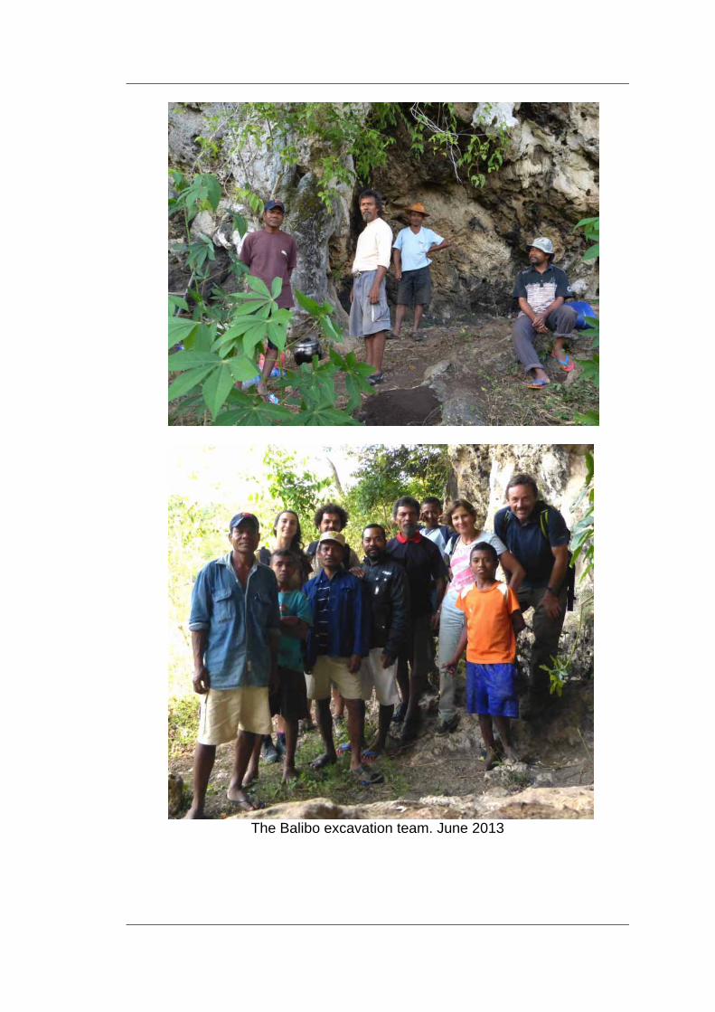
The Balibo excavation team. June 2013