ial community meeting 3 presentation
TRANSCRIPT

TAC Meeting 3 | November 14, 2017
1
WHAT ARE THE CITY’SRECOMMENDATIONS FOR IMPORTANT AGRICULTURAL LANDS?
Community Meeting 3November 20, 2017
O‘ahu IAL Mapping Project
TAC Meeting 3 | November 14, 2017
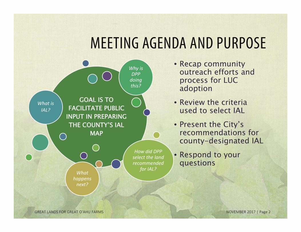
GOAL IS TO FACILITATE PUBLIC
INPUT IN PREPARING THE COUNTY’S IAL
MAP
What is IAL?
Why is DPP doing this?
How did DPP select the land recommended
for IAL? What
happens next?
MEETING AGENDA AND PURPOSE• Recap community
outreach efforts and process for LUC adoption
• Review the criteria used to select IAL
• Present the City’s recommendations for county-designated IAL
• Respond to your questions
GREAT LANDS FOR GREAT O‘AHU FARMS NOVEMBER 2017 | Page 2

TAC Meeting 3 | November 14, 2017
PROJECT TEAMMAYOR’S AGRICULTURAL LIAISON
Dr. Po Yung Lai
DEPARTMENT OF PLANNING AND PERMITTING
Kathy Sokugawa, Acting DirectorEugene Takahashi, Ray Young, Franz Kraintz
HHF Planners
Scott Ezer, Principal PlannerRob James, Corlyn Orr, Erin Higa, Alex Felix
Kem Lowry Bruce Plasch
GREAT LANDS FOR GREAT O‘AHU FARMS NOVEMBER 2017 | Page 3
TAC Meeting 3 | November 14, 2017
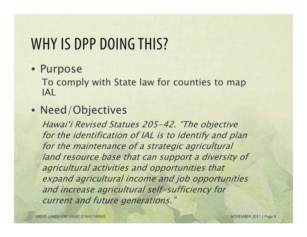
WHY IS DPP DOING THIS?• Purpose
To comply with State law for counties to map IAL
• Need/Objectives Hawai‘i Revised Statues 205-42. “The objective for the identification of IAL is to identify and plan for the maintenance of a strategic agricultural land resource base that can support a diversity of agricultural activities and opportunities that expand agricultural income and job opportunities and increase agricultural self-sufficiency for current and future generations.”
GREAT LANDS FOR GREAT O‘AHU FARMS NOVEMBER 2017 | Page 4

TAC Meeting 3 | November 14, 2017
HISTORY OF IAL
GREAT LANDS FOR GREAT O‘AHU FARMS NOVEMBER 2017 | Page 5
1978
State Constitutional Convention
•ARTICLE XI, SECTION 3, STATE CONSTITUTION “The State shall conserve and protect agricultural lands, promote diversified agriculture, increase agricultural self-sufficiency and assure the availability of agriculturally suitable lands. The legislature shall provide standards and criteria to accomplish the foregoing….”
2005
2008
State Legislation
•CHAPTER 205, PART III, HAWAI‘I REVISED STATUTES•Definition of IAL•Policies for the long term agricultural use of IAL•8 standards and criteria to be used in mapping •Landowners, counties and State processes for identifying lands with potential for IAL
•Roles/duties of select state-county agencies•Incentives for agricultural operations on IAL
2009 •Kaua‘i County begins mapping
2011 •City and County of Honolulu begins mapping
TAC Meeting 3 | November 14, 2017
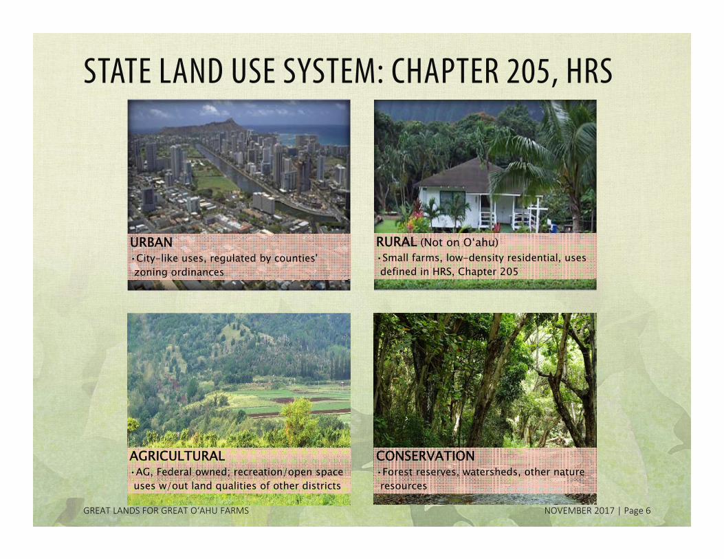
STATE LAND USE SYSTEM: CHAPTER 205, HRS
URBAN•City-like uses, regulated by counties' zoning ordinances
RURAL (Not on O‘ahu)•Small farms, low-density residential, uses defined in HRS, Chapter 205
AGRICULTURAL•AG, Federal owned; recreation/open space uses w/out land qualities of other districts
CONSERVATION•Forest reserves, watersheds, other nature resources
GREAT LANDS FOR GREAT O‘AHU FARMS NOVEMBER 2017 | Page 6
TAC Meeting 3 | November 14, 2017
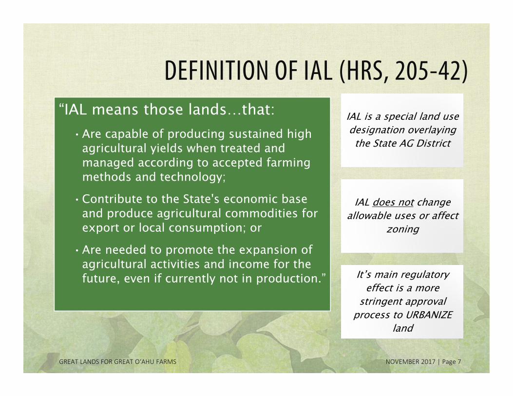
DEFINITION OF IAL (HRS, 205-42) “IAL means those lands…that:
•Are capable of producing sustained high agricultural yields when treated and managed according to accepted farming methods and technology;
•Contribute to the State's economic base and produce agricultural commodities for export or local consumption; or
•Are needed to promote the expansion of agricultural activities and income for the future, even if currently not in production.”
GREAT LANDS FOR GREAT O‘AHU FARMS NOVEMBER 2017 | Page 7
IAL is a special land use designation overlaying the State AG District
IAL is a special land use designation overlaying the State AG District
IAL does not change allowable uses or affect
zoning
IAL does not change allowable uses or affect
zoning
It’s main regulatory effect is a more
stringent approval process to URBANIZE
land
It’s main regulatory effect is a more
stringent approval process to URBANIZE
land

TAC Meeting 3 | November 14, 2017
LONG-TERM GOALS OF IAL
GREAT LANDS FOR GREAT O‘AHU FARMS NOVEMBER 2017 | Page 8
Help farming be an economically viable activity
Ensure that the best of O‘ahu’s high-quality farm land is protected and preserved for long-term agricultural use
Guide decision-making in the State Agricultural District

TAC Meeting 3 | November 14, 2017
3 PROCESSES TO DESIGNATE LANDS AS IAL State Land Use Commission is the approving authority
for all 3 processes
County Initiated
County Planning Departments
identify candidate IAL on
specific lands
Landowner InitiatedVoluntary
process for landowners to
petition the LUC
State Initiated
State DOA and DLNR identify
candidate IAL on State-owned, public lands
GREAT LANDS FOR GREAT O‘AHU FARMS NOVEMBER 2017 | Page 9

TAC Meeting 3 | November 14, 2017
COUNTY-INITIATED PROCESS
DPP prepares resource maps
(Phase I)
Community engagement• Focus groups•3 rounds of public meetings
• Landowner notification
•Written comments
DPP finalizes IAL Map and
accompanying report;
transmits to City Council
City Council reviews and adopts via resolution;
transmits to LUC
LUC issues written
decision to designate IAL
GREAT LANDS FOR GREAT O‘AHU FARMS NOVEMBER 2017 | Page 10
2011-2014 2014-2017 Jan-Feb 2018

TAC Meeting 3 | November 14, 2017
COMMUNITY PARTICIPATION OPPORTUNITIES
GREAT LANDS FOR GREAT O‘AHU FARMS NOVEMBER 2017 | Page 11
Nov 2014 to Feb 2015•PROJECT REFINEMENT
•TAC Meeting 1, Dec-8-2014•3 small group meetings, Jan-Feb 2015
March to May 2015•INFORMATION GATHERING
•Community Meeting 1, Apr 2015 (Mililani, Kaneohe, Kapolei)•60-day public comment period
Dec 2015 to Apr 2017
•MAP FORMATION•TAC Meeting 2, Dec-8-2015•Community Meeting 2, Jan-2017 (Haleiwa, Kapolei)•Landowner notifications and 60-day comment period
Nov 2017 to Feb 2018•MAP COMPLETION & PROJECT DOCUMENTATION
•TAC Meeting 3, Nov-14-2017•Community Meeting 3, Nov-20-2017 (Aiea)
TBD•CITY COUNCIL ADOPTION BY RESOLUTION
•Council hearings
TBD•LUC REVIEW AND ADOPTION
•LUC hearings
TAC Meeting 3 | November 14, 2017
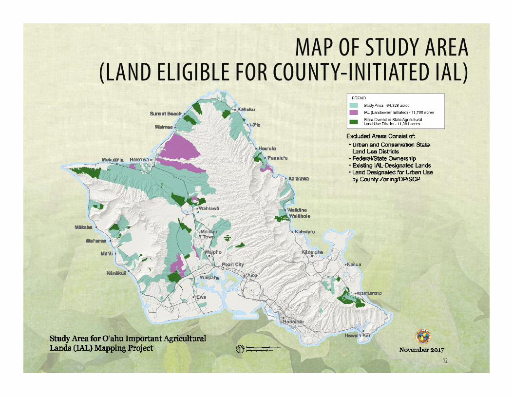
12
MAP OF STUDY AREA (LAND ELIGIBLE FOR COUNTY-INITIATED IAL)
TAC Meeting 3 | November 14, 2017
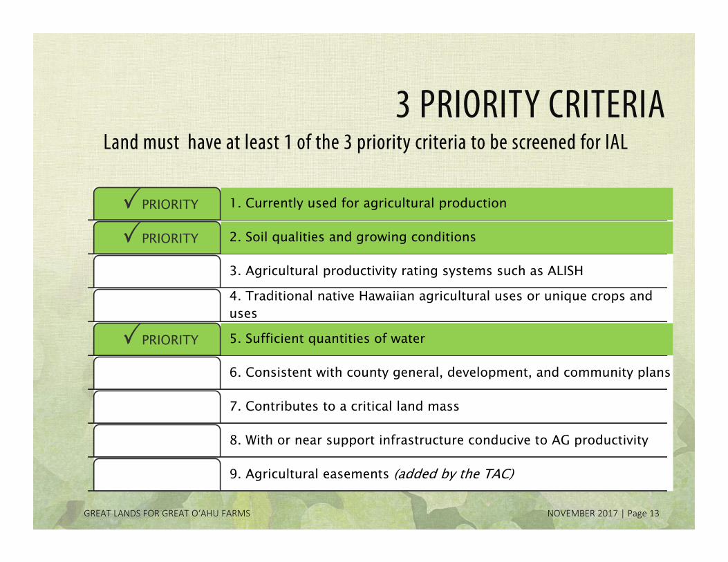
3 PRIORITY CRITERIA
1. Currently used for agricultural productionPRIORITY
2. Soil qualities and growing conditionsPRIORITY
3. Agricultural productivity rating systems such as ALISH
4. Traditional native Hawaiian agricultural uses or unique crops and uses
5. Sufficient quantities of waterPRIORITY
6. Consistent with county general, development, and community plans
7. Contributes to a critical land mass
8. With or near support infrastructure conducive to AG productivity
9. Agricultural easements (added by the TAC)
Land must have at least 1 of the 3 priority criteria to be screened for IAL
GREAT LANDS FOR GREAT O‘AHU FARMS NOVEMBER 2017 | Page 13

TAC Meeting 3 | November 14, 2017
DRAFT DEC-2016 IAL MAP (52,575 acres)MapOahuAgLand.com
GREAT LANDS FOR GREAT O‘AHU FARMS NOVEMBER 2017 | Page 14
Website map viewer to be updated with the Final IAL Map and comments

TAC Meeting 3 | November 14, 2017
PRIORITY CONCERNS FROMCOMMUNITY MEETING 2
• Defend Ho‘opili and Koa Ridge lands (no more development on O‘ahu)
• Increase food self-sufficiency; use AG land to grow food
• IAL designation makes it easier for developers to rezone unimportant AG land
• How will IAL affect my land value and future development potential?
• Fear of adding another layer of regulation; unsure about future use restrictions on IAL
• Mistrust/objections to government initiatives; feeling that the public is not being heard
• Consideration of small farmers and family farms vs. corporate farming interests
• Want to ensure consistency with General Plan and Development Plans/Sustainable Communities Plans
• Balanced representation on the TAC
GREAT LANDS FOR GREAT O‘AHU FARMS NOVEMBER 2017 | Page 15

TAC Meeting 3 | November 14, 2017
LAND PROPOSED FOR IAL DESIGNATION

TAC Meeting 3 | November 14, 2017
STATE IAL QUALIFIED AG COST TAX CREDITPROVIDES TAX CREDITS FOR:• Roads and utilities serving IAL• AG processing facilities• Water wells, reservoirs, dams, storage facilities,
pipelines or irrigation systems• Agricultural housing• Feasibility studies, regulatory processing, legal
and accounting services related to items above• Equipment used to cultivate, harvest or process
AG products• Regulatory processing, studies, legal and other
consultant services related to obtaining/retaining sufficient water for AG activities and retaining the right to farm on IAL
GREAT LANDS FOR GREAT O‘AHU FARMS NOVEMBER 2017 | Page 17
This year’s Legislature failed to re-authorize the
IAL tax credit
Tax credit expires at end of tax year 2017

TAC Meeting 3 | November 14, 2017
COMMENTS RECEIVED ON DRAFT MAP
93 letters from: •4 State agencies•7 County agencies•7 individuals•1 community organization•74 landowners (both individuals + corporations)
Of the 93 letters: •67 landowners requested exclusion from IAL (38 granted)•6 landowners requested to be included as IAL (5 granted)•20 were comments from other interested parties
GREAT LANDS FOR GREAT O‘AHU FARMS NOVEMBER 2017 | Page 18
TAC Meeting 3 | November 14, 2017
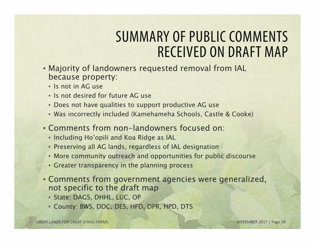
SUMMARY OF PUBLIC COMMENTS RECEIVED ON DRAFT MAP
• Majority of landowners requested removal from IAL because property:• Is not in AG use• Is not desired for future AG use• Does not have qualities to support productive AG use• Was incorrectly included (Kamehameha Schools, Castle & Cooke)
• Comments from non-landowners focused on: • Including Hoʽopili and Koa Ridge as IAL• Preserving all AG lands, regardless of IAL designation• More community outreach and opportunities for public discourse• Greater transparency in the planning process
• Comments from government agencies were generalized, not specific to the draft map• State: DAGS, DHHL, LUC, OP• County: BWS, DDC, DES, HFD, DPR, HPD, DTS
GREAT LANDS FOR GREAT O‘AHU FARMS NOVEMBER 2017 | Page 19

TAC Meeting 3 | November 14, 2017
DPP MAP REVISIONS
GREAT LANDS FOR GREAT O‘AHU FARMS NOVEMBER 2017 | Page 20
DPP considered additional criteria in refining the draft map
Most parcels added were due to • context and critical mass (i.e.,
surrounded by IAL parcels of same owner; Criteria 7)
• corrections for mapping errors
FOR QUESTIONS, CONTACT:Raymond Young, Staff PlannerDepartment of Planning and Permitting 650 S. King Street, 7th Floor Honolulu, Hawaii 96813 Ph: (808) 768-8049 Email: [email protected]
Most parcels removed were due to• urban designated use (i.e., Country zoning which allows residential
use, those proposed for future urbanization) • corrections for mapping errors (i.e., zoned for urban use and
already built with dwellings)
Some added or removed parcels had a combination of the above
MAHALO NUI