i deep river trail conceptual plan
TRANSCRIPT


i Deep River Trail Conceptual Plan
Acknowledgements
Randolph County Board of Commissioners
David Allen, Chairman
Darrell Frye, Vice Chairman
Stan Haywood
Kenny Kidd
Maxton McDowell
Randolph County Tourism Development Authority
David Caughron, Chairman
Mary Joan Pugh, Vice‐Chair
Gail Morgan, Board Member
Barbara Gallimore, Board Member
Rebecca Petty Moffitt, Board Member
Shawn Patel, Board Member
Ross Holt, Board Member
Luke Hollingsworth, Board Member
Marianne Rowe, Board Member
Tammy O’Kelley, Executive Director
Amber Renee Skeen, Clerk to the Board
Deep River Trail Task Force
Perry Connor, Town of Franklinville
Jay Dale, County of Randolph
Jesse Day, Piedmont Triad Regional Council
Tom Jordan, Cedar Falls Community
Kerri Lindley, Town of Ramseur
Trevor Nuttall, City of Asheboro
Tammy O'Kelley, Executive Director
Greg Patton, City of Randleman
Jim Plant, At Large
Mary Joan Pugh, Task Force Chair
Smith Raynor, NC State Parks ‐ Regional Trails
Specialist
Amber Renee Skeen, Clerk to the Task Force
Jim Rich, A3 Healthy Communities
April Thornton, Randolph Hospital Foundation
Mac Whatley, RC Historic Landmark Preservation
Commission
Mac Whatley, RC Historic Landmark Preservation
Commission
Consulting Staff, Piedmont Triad Regional Council
Jesse Day, Regional Planning Director
Malinda Ford, GIS Manager
Joe Furstenberg, Regional Planner
Elizabeth Jernigan, Assistant Planning Director
Kelly Larkins, Regional Planner II
Anna Leonard, Environmental Programs Coordinator

ii Deep River Trail Conceptual Plan
Table of Contents
Project Purpose and Goals ...............................................................................................................1
Study Area Sections and Distance .................................................................................................1
Goals & Implementation Strategy.................................................................................................2
Background and History ..................................................................................................................4
Livability and Economic Benefits ..................................................................................................4
History........................................................................................................................ ................5
Project Approach ............................................................................................................................6
Field Work ..................................................................................................................................6
Planning Context .........................................................................................................................6
Opportunities and Constraints .........................................................................................................7
Opportunities..............................................................................................................................7
Constraints .................................................................................................................................7
Natural and Environmental Findings.................................................................................................9
North Carolina Wildlife Action Plan ..............................................................................................9
Identified Rare Species ................................................................................................................9
Feasibility Analysis and Preferred Trail Alignment ........................................................................... 10
Section 1. Randleman to Worthville........................................................................................... 11
Section 2. Worthville to Central Falls .......................................................................................... 15
Section 3. Central Falls to Cedar Falls .......................................................................................... 19
Section 4. Cedar Falls to Franklinville .......................................................................................... 23
Section 5. Franklinville to Ramseur ............................................................................................. 27
Section 6. Ramseur .................................................................................................................... 31
Deep River Blueway Trail ............................................................................................................... 34
River Conditions and Portages.................................................................................................... 35
Recent Progress & Action Steps ..................................................................................................... 36
1. Land Trail .............................................................................................................................. 36
2. Blueway ................................................................................................................................ 36
3. Environmental Stewardship.................................................................................................... 36
4. Maintenance ......................................................................................................................... 37
[THIS PAGE INTENTIONALLY LEFT BLANK]

1 Deep River Trail Conceptual Plan
PROJECT PURPOSE AND GOALS
The Deep River became a State Trail in 2007 through special legislation in the General Assembly. The
authorization did not provide funding to implement the trail, but did give priority for communities along
the river who may want to access recreation trail grants to construct and maintain trail in the corridor.
Soon after, the City of Randleman and the Town of Franklinville opened sections of trail along the Deep
River. The Town of Ramseur also secured a Clean Water Management Trust Fund grant to complete a
detailed alignment of the trail in the Town of Ramseur.
In 2015 a Deep River Trail Task Force was formed by the Randolph County Tourism Development Authority
with local, regional, and state government representatives as well as recreation and trail advocates to
continue coordinating efforts for planning,
design, construction and management of the
Deep River Trail in Randolph County. A task
force report was completed in 2016
inventorying the status of trail development
along the Deep River, while also providing
recommendations on key plans, designs and
other actions to move trail development
forward. The completion of this Deep River
Trail Conceptual Plan, provides alignment
alternatives and recommendations for the
proposed Deep River trail from Randleman to
Ramseur. The recommendations are divided
up into the following six sections, which also
correspond to the map.
STUDY AREA SECTIONS AND DISTANCE 1. Randleman to Worthville 3 Miles 2. Worthville to Central Falls 3 Miles 3. Central Falls to Cedar Falls 3 miles 4. Cedar Falls to Franklinville 2.75 miles 5. Franklinville to Ramseur 2 miles 6. Ramseur 1.25 miles
Figure 1 ‐ Deep River Trail Sections (2016 Task Force Report)

2 Deep River Trail Conceptual Plan
GOALS & IMPLEMENTATION STRATEGY The Deep River Trail Task Force developed broad goals, barriers and opportunities for trail development
in the spring of 2017.
Why is the Deep River Trail important for your community, the County and the region? It will…
Improve quality of life,
Expand recreation and economic
opportunities,
Increase health and fitness,
Protect the environment,
Promote tourism, recreation and
wellness,
Connect and preserve the identity
of communities along the river,
Connect to nature and education,
Provide a “no cost” activity for
young families,
Amenity to attract new citizens,
Preserve natural areas along the
river from development, and
Teach citizens and visitors about
the history of the river.
How can the barriers to and
opportunities from trail
development be addressed?
Barriers: Landowner opposition,
funding, few existing trails, major
creek crossings
Opportunities: Blueway trails and
dam portages, economic benefits,
tourism, health, fitness and
recreation
Photo 1: Task Force Members Discuss the Trail with a Landowner
Deep River Trail Vision
The Deep River Trail will connect
communities all along the Deep River. The
trail will be an anchor for recreation and
tourism in Randolph County, connecting
people with nature and the river. The trail
will be easily accessible for the community at
large and will connect to other local, regional
& State trail networks. The Deep River Trail
will be used as an alternate form of
transportation and provide a place for
visitors and citizens to exercise, recreate,
and experience the outdoors on the Deep
River.

3 Deep River Trail Conceptual Plan
Barriers & Opportunities with Example Strategies
1. Explain the vision of the Deep River Trail to as many audiences as possible
o Gather community partners and deliver presentations.
o Work with landowners individually and discuss the vision of the trail.
2. Implement a County property tax benefit and explain State and federal tax incentives for trail
easement dedication
o Dedicate funding for legal costs of easement acquisition.
3. Incorporate trail easement dedication through the subdivision process for adopted trails for Randolph
County, Randleman, Asheboro, Franklinville and Ramseur
4. Develop public and private funding sources
for trail and bridge design and construction
o Leverage grant opportunities from State
(e.g. tourism or NCDOT) and private
foundations.
5. Develop river access and trail in the middle
section of the Deep River (e.g. Central Falls
and the landfill property)
o Acquire easements now where trail
alignment is known (e.g. along rail bed),
o Build trails on County landfill property,
and
o Get further sections of trail completed to gain momentum and educate citizens on trail potential.
6. Creek crossings
o Complete engineering studies to know the length and design constraints of bridges
o See how the Sandy Creek bridge crossing design study can be a model for other large
crossings (e.g. Harlan’s Creek, Bush Creek, Gabriel’s Creek)
o Select crossing locations with least impact to floodplain and sensitive areas
7. Focus on river blueway and portage trails around dams
o Construct a boat launch in the Old Liberty Road Area and
o Connect the river to RCC, local campgrounds and churches.
8. Promote economic development and benefits (e.g. Virginia Creeper Trail)
o Low cost infrastructure,
o Take an economic “snapshot” prior to construction and monitor economic benefits (e.g. sales tax,
room tax and trips) after the trail is complete, and
o Highlight studies of economic benefit related to trails development.
9. Advertise nature tourism
o Continue to market the trail to hikers, walkers and families and
o Promote through outfitter and restaurant partnerships and signage
10. Market health, exercise and passive recreation benefits of trail implementation
11. Expand the work of the Deep River Trail Task Force
o Conduct stewardship programs on the Deep River including stream and river clean‐ups,
o Conduct private fundraising campaign providing matching funds for private, local, state and federal
grants, and
o Work with willing landowners to acquire trail easements.
12. Seek adoption of the Deep River Trail Conceptual plan by Randolph County, Randleman, Asheboro,
Franklinville and Ramseur
Photo 2: Task Force Member Paddling Above Cox's Dam

4 Deep River Trail Conceptual Plan
BACKGROUND AND HISTORY
The Deep River Trail is envisioned to be a multi‐use trail and blueway alongside the Deep River and
through communities once supported by the rail line, textile manufacturing, and the river. Though the
steel rails, wooden cross‐ties and river barges were removed decades ago, it is easy to see where industry
and commerce once thrived along the river.
The trail will connect small towns and communities in new ways, allowing participants to reconnect to the
remnants of history and culture along the abandoned rail line and mill villages that relied on the river for
power. The trail will offer citizens a chance to get out of their cars and experience the outdoor luxuries
of trees, shade, birdsongs, and views of the scenic Deep River. It will be a haven for walkers, cyclists,
runners, paddlers and families away
from the noise of vehicular traffic. The
trail provides an important link in a
developing multi‐county trail system.
In 2007, legislation was passed
authorizing the establishment of “The
Deep River State Trail” as part of the
state park system. The State Trail
would encompass a network of
conservation lands and recreation
features including trails, water access,
parks and other amenities stretching
along the Deep River corridor from its
headwaters in Guilford County through
Randolph, Chatham, and Moore
Counties down to the confluence with
the Cape Fear River.
LIVABILITY AND ECONOMIC BENEFITS A safe place for outdoor physical activity: Few rural communities have access to safe places to walk or
bicycle. Rail‐trails provide opportunities to be active without interacting with motorized traffic. Because
rail lines were once major transportation corridors, they connect communities to town and community
centers.
A place to enjoy nature: Trails and greenways often provide wildlife habitat. The location of the rail trail
along the Deep River will preserve its riparian buffer. The mature vegetation and wooded forests that
make up the riparian corridor provides critical habitat for terrestrial and aquatic species, providing a
unique wildlife viewing experience.
A place for recreation: The trail connection from Ramseur to Franklinville will offer varied walking, running
and bicycling distance options for residents from each town. Twenty minutes of elevated heart rate per
day can provide a tremendous benefit to human health and fitness. In addition to walking and bicycling,
the trail will also access locations for picnicking, fishing, and will provide canoe/kayak sites designated as
part of the State Park Deep River Trail.
Figure 2 ‐ Deep River State Park Trail

5 Deep River Trail Conceptual Plan
More transportation options, lower transportation costs, and cleaner environment: The trail will develop
safe, reliable, and affordable transportation choices that reduce energy consumption, and improve air
quality. The trail when fully implemented will connect communities to their schools giving children a safer
route to walk or bicycle to and from school.
Valuable asset for communities and neighborhoods: The trail will be a unique asset to the communities
and neighborhoods adjacent to the trail. There are several studies that indicate property values increase
when adjacent to trails.
Economically viable/sustainable community development: Trails are an excellent way to increase
community revitalization. Companies increasingly seek communities that provide amenities that enhance
employees’ quality of life. Trails and greenways are one of the most sought after amenities. Longer trails
offer a regional draw for tourism as well. And this trail will link up with a network of other trails and
greenways and act as a cornerstone for regional economic competitiveness.
HISTORY The Deep River is rich in historical importance for both the development of Randolph County and the
North Carolina Piedmont region.
The earliest known humans to settle in the area were visited in 1701 by the English explorer John Lawson,
who recorded his encounter in a book titled “A New Voyage to Carolina” published in 1709. As Lawson
traveled through the Carolina backcountry for the colonial authorities, his small expedition came across a
Native American tribe called the Keyauwee or Caraway.
In part due to the interest generated by Lawson and other explorers, the Province of North Carolina saw
an increasing number of English, Scotch‐Irish, and German pioneers who began settling and establishing
farms and mills in the area. This domestic peace was later shattered by the outbreak of war between the
Colonies and Great Britain, with Randolph County and the Deep River providing a backdrop to several
skirmishes between Patriots and Loyalists.
After the war, the strong flow of the Deep River provided resourceful citizens with the necessary energy
to begin powering mills. These
developments not only improved the lives
of those who built and ran the factories, but
it also helped bring Randolph County into
the Industrial Revolution. Starting in 1836,
factories began to appear in Cedar Falls,
Randleman, Franklinville, and Ramseur
making Randolph County one of three of
the largest centers of manufacturing in the
state by the outbreak of the Civil War. By
the 1880’s, more factories sprung up in
communities such as Worthville and
Central Falls. In the early 20th century, the
factories in these communities were served
by a gasoline powered barge with the main
purpose of shuttling raw cotton down river to be dyed.
(Source: https://randolphhistory.wordpress.com/?s=Deep+River )
Photo 3: Worthville Covered Bridge looking south toward factory. Photo courtesy of Mac Whatley.

6 Deep River Trail Conceptual Plan
PROJECT APPROACH
FIELD WORK Field work was conducted by boat and by foot between January and April 2017. Cameras equipped with
GPS systems were used to gather natural and cultural features along the study corridor. Areas along the
river were investigated for trail constructability. Factors affecting constructability include wetlands,
existing structures (homes, utilities, dams and businesses), stream outlets to the Deep River, roads,
topography and landfill operations. Each part of the corridor has unique opportunities and challenges for
design, construction, management and maintenance based upon the varying conditions of the corridor.
PLANNING CONTEXT In addition to the efforts to construct trail in Randleman, Franklinville and Ramseur, other plans were
reviewed to inform this Conceptual Plan. The following plans reference the Deep River Trail:
Deep River Trail Task Force Report (2016)
Trail inventory and action plan for the Deep River Trail Task force and partners, foundational
document for this Conceptual Plan
Randolph County Strategic Plan (2016)
Example strategy for Well‐Being and Quality of Life: Coordinate with partners to market and
brand the developing Deep River Trail
Piedmont Triad Trails Inventory (2011)
Identifies the Deep River State Trail and other proposed trails in Randolph County as part of a
larger regional & State trail network.
Deep River Rail Trail Master Plan (2011)
Detailed alignment, cost estimates, surveys and other information on Section 6 (Town of
Ramseur and Clean Water Management Trust Fund) of this Conceptual Plan.
Randolph County Growth Management Plan (2009)
Policy recommendations include supporting tourism and land development that preserves and
protects water quality.
Other municipal planning and committee efforts have also helped to inform and educate citizens and
government staff on the history, culture and ecological uniqueness of the Deep River corridor. Each grant
application, committee meeting, public event has moved the trail development forward. This Conceptual
Plan will build from the progress already made over the last decade to plan, design and implement trail
sections.

7 Deep River Trail Conceptual Plan
OPPORTUNITIES AND CONSTRAINTS
OPPORTUNITIES River Access A number of potential outdoor recreational opportunities including fishing, canoeing/kayaking, and
swimming could grow. There is limited advanced or technical water to attract expert paddlers, but the
Deep River provides ample opportunities for beginner paddlers and groups. New swimming areas like
the one planned at the old Worthville mill and dam will provide new public recreation opportunities on
the Deep River.
Existing Trail The natural surface multi‐use trail
constructed by the City of Randleman and
the Town of Franklinville offer trail
experiences on either end of the
conceptual plan study area. Franklinville’s
section is on a former rail bed providing a
very accessible pathway. The City of
Randleman offers a mix of a wide and flat
trail to more technical hiking trails
sections. The City of Randleman and Town
of Franklinville have both utilized Clean
Water Management Trust Fund,
Recreation Trails Program and additional
funding sources to build trail sections.
North Carolina Zoo The North Carolina Zoo is not in the immediate vicinity of the study area, however the Zoo has been and
continues to be a tourism draw for Randolph County. Partnerships in recreation marketing, branding
and programming will be an ongoing opportunity for increasing recreation users on the Deep River Trail
as it is implemented.
Publicly Owned Property The County and Randolph Community College own a large part of the land in Section 3 of the study area
from Central Falls to Cedar Falls. This middle section has no trail or publicly accessible points on the
river, making it a prime opportunity to demonstrate the benefits of public recreational access on the
Deep River. Other sections, including many in Franklinville and Ramseur have acquired trail easements
or purchased property for trail development.
CONSTRAINTS Hydro‐electric dams There are six dams in the study area, two of which are actively generating electric power. The other
four dams have either been breached slightly or the hydro‐electric equipment has not been maintained.
More detail is provided below for each section in Feasibility Analysis & Preferred Trail Alignment.
Photo 4: Randleman Deep River Trail Boy Scout Bridge Credit: City of Randleman

8 Deep River Trail Conceptual Plan
Wetlands There are parts of Section 2 and
3 that have significant wetland
challenges close to the Deep
River. Either re‐routing or low
impact boardwalk construction
will be necessary to complete
trail in these areas.
Large Creeks There are several large creek
tributaries of the Deep River
that will provide challenges to
trail implementation. Some of
the largest creek crossings
include Haskett’s, Gabriel,
Sandy and Harlan’s Creek
crossings require a 50 ft or
longer bridge to cross. Alternative trail alignment options for crossing at these locations are suggested to
either minimize environmental impact or construction costs.
Land Use There are several mills and villages in study area. Three active mills; Prestige Fabricators (Central Falls)
and Sapona Mill (just downstream of Cedar Falls) and Deep River Fabricators (Franklinville) continue to
operate, but many others have been shuddered in the last few decades. The section between Cedar Falls
and Ramseur used to have an
active rail line that supported the
mills and additional industrial
development along the corridor.
It has been over 30 years since
that rail line was removed, tracks
and bridges included. In some
streams the piers for the bridges
remain, which following
inspection may be used to
support a pedestrian bridge.
Additionally, residential
development, boat and truck
repair businesses, civic
organizations, active and
inactive landfills, an RV Park and
some additional small scale
commercial development are
located in the study area.
Photo 5: Sandy Creek Crossing with US 64 Bridge Above Credit: Town of Franklinville
Photo 6: View of Cedar Falls Closed Mill from Bridge over Deep River

9 Deep River Trail Conceptual Plan
NATURAL AND ENVIRONMENTAL FINDINGS
The Deep River is located in the Cape Fear River Basin, the largest river basin in North Carolina. Major
drainages in the basin include the Haw River, Deep River, Northeast Cape Fear River and Black River.
NORTH CAROLINA WILDLIFE ACTION PLAN The NC Wildlife Resources Commission Wildlife Action Plan addresses local, regional, and state‐wide
concerns across key terrestrial and aquatic habitats and identified critical knowledge gaps and future data
needs.
The Upper Cape Fear River Basin is included in this plan and documents aquatic resource conditions,
aquatic species, threats to aquatic species, and basin specific recommendations. There are 35 species of
greatest conservation need (SGCN) in the basin: two aquatic snails, two crayfish, 18 freshwater or
anadromous fishes, and 13 mussels.
Access to the Deep River and historic spawning habitats in the upper Cape Fear River basin is currently
blocked by Lockville Dam near the mouth of the Deep River. Fish passage around these obstructions is
needed for migratory fish to reach historic spawning sites in the Deep River. Restoring migratory fish
access to historic spawning and nursery habitats will help rebuild currently depressed populations to
support healthy ecosystems and sustainable recreational and commercial fisheries
The Wildlife Action Plan recommends long‐term monitoring to assess species and ecosystem health over
time. These efforts will inform species and habitat management decisions. The state plan supports well
planned stream restoration, dam removal, and identifying conservation areas critical to aquatic
ecosystem health.
IDENTIFIED RARE SPECIES A query of the North Carolina Natural Heritage Program (NCNHP)
database indicates records for rare species within the proposed
project boundary. The rare species listed in Table 1 have been
documented within a one‐mile radius of the Deep River between
Randleman and Ramseur. The proximity of these records suggest
these NHP elements may potentially be present in the project
area if a suitable habitat exists.
Table 1: NCNHP Elements Documented in Project Area
Taxonomic Group Scientific Name Common Name Federal Status State Status Natural Community Dry‐Mesic Oak ‐‐ ‐‐ ‐‐ Natural Community Dry Oak ‐‐ ‐‐ ‐‐
Natural Community Piedmont Monadnock ‐‐ ‐‐ ‐‐ Natural Community Piedmont Cliff ‐‐ ‐‐ ‐‐
Vascular Plant Helianthus schweinitzii Schweinitz’s Sunflower Endangered Endangered Vascular Plant Trifolium reflexum Buffalo Clover ‐‐ Threatened
Dragonfly/ Damselfly Gomphus abbreviates Spine‐crowned Clubtail ‐‐ Significantly Rare
Figure 3: Schweinitz’s sunflower is a fall blooming plant native to the Piedmont region of NC and SC. It is found in only 12 counties in NC and 2 counties in SC.

10 Deep River Trail Conceptual Plan
FEASIBILITY ANALYSIS AND PREFERRED TRAIL ALIGNMENT
Deep River Trail Conceptual Plan Bridge Details Bridge
Number Stream Name Parcel
Number PIN Distance
Feet Accuracy Floodzone 1 None 792209 7764792209 25 Estimate 100 Year 2 None 507469 7765507469 25 Estimate 100 Year 3 None 522400 7765522400 25 Estimate 100 Year 4 None 936004 7764936004 30 100 Year 5 None 997864 7763997864 35 Estimate 100 Year 6 Haskett Creek 954481 7763954481 75 Estimate Floodway 7 None 37192 7773037192 50 Estimate 100 Year 8 None 306535 7773306535 25 Estimate 100 Year 9 None 306535 7773306535 20 Estimate N 10 None 306535 7773306535 17 N 11 None 690956 7772690956 12 500 Year 12 Cox Creek 695926 7772695926 35 N 13 None 797876 7772797876 20 100 Year 14 Gabriels Creek 971865 7772971865 45 100 Year 15 Deep River 190362 7782190362 360 Estimate Floodway 16 None 999429 7772999429 25 Estimate 100 Year 17 Bush Creek 72600 7792072600 125 100 Year 18 Sandy Creek 20881 8702020881 115 Floodway 19 Harlan's Creek 325006 8702325006 195 100 Year
Key improvements, barriers and opportunities are identified for the trail sections under review from Randleman to Ramseur in this chapter. This overview map comprises the scope of the Deep River study area.

11 Deep River Trail Conceptual Plan
SECTION 1. RANDLEMAN TO WORTHVILLE Section Distance: 3 Miles; Completed Trail: 1.5 miles; Funded Trail: 1.5 miles
Preferred Alignment: Southwest side or river right
Stream Crossings: 3 (Map ID 1 ‐25ft, 2‐25ft, 3‐25ft, estimated distance)
Summary: This section starts in the City of Randleman
where 1.5 miles of existing trail begins at N. Main
Street and the Deep River. The trail is on the
southwest side of the Deep River. Funding has been
secured for implementing 1.5 miles of trail to get to
the closed Worthville Mill. As shown in the pictures
below, there are topographic challenges to
constructing the trail along this corridor, including
rock outcroppings and streams. The trail will meander
and narrow in some of these locations, but will
eventually tie into the Worthville Mill and village area.
The historic Worthville mill village will be connected
via trail to the City of Randleman. Grants and land
acquisition around the old Worthville mill and dam,
will create a destination for trail users.
Key Improvements:
Continue to utilize Recreation Trails Program and Duke Energy foundation funding to acquire
easements and implement trail development towards Worthville;
Seek grant funding to develop recreation improvements (e.g. swimming, boat access and
picnicking) adjacent to the trail near Worthville dam; and
Continue to market the existing sections of trail and plan for pedestrian improvements along
roadways that connect downtown Randleman to the Deep River.
Photo 7: Randleman Deep River Trail

12 Deep River Trail Conceptual Plan
13 Deep River Trail Conceptual Plan
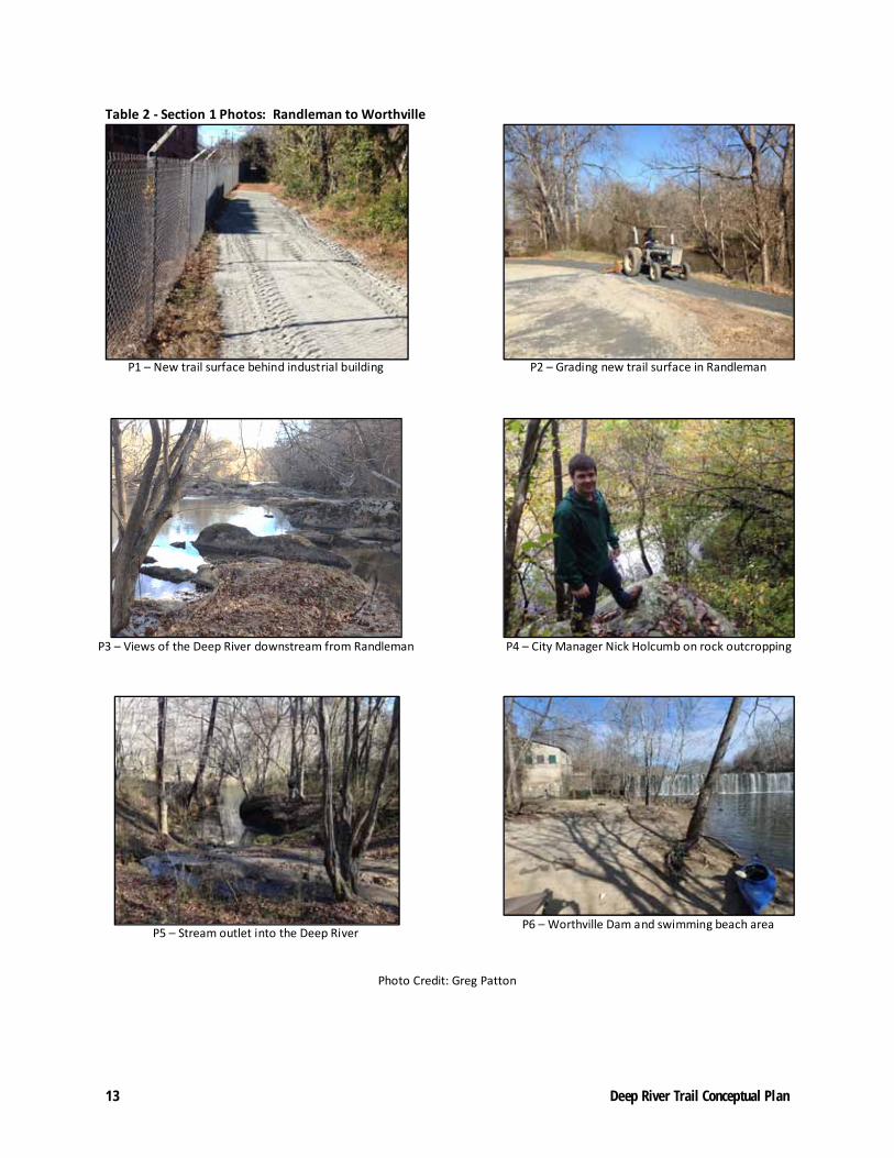
Table 2 ‐ Section 1 Photos: Randleman to Worthville
P1 – New trail surface behind industrial building
P2 – Grading new trail surface in Randleman
P3 – Views of the Deep River downstream from Randleman
P4 – City Manager Nick Holcumb on rock outcropping
P5 – Stream outlet into the Deep River
P6 – Worthville Dam and swimming beach area
Photo Credit: Greg Patton

14 Deep River Trail Conceptual Plan
[THIS PAGE INTENTIONALLY LEFT BLANK]

15 Deep River Trail Conceptual Plan
SECTION 2. WORTHVILLE TO CENTRAL FALLS Section Distance: 3 Miles; No Completed Trail
Preferred Alignment: Southwest side or river right
Stream Crossings: 3 (Map ID 4‐30ft, 5‐35ft, 6‐75ft, estimated distance)
Summary: This section
begins below the
Worthville Mill and Dam.
The City of Randleman has
acquired approximately
157 acres immediately
downstream from the old
mill, with opportunities for
recreation including
swimming access and trail
development. Going
downstream, privately
held land exists on both
sides of the river to Central
Falls. Land trail feasibility
was primarily investigated
on the southwest side of the river where Worthville and Central Falls villages are located. The middle of
this section on river right includes a large wetland area, providing challenges to implementation. More
groundwork following discussions with willing landowners will inform the trail routing through the
wetlands area. The route for the trail is located along WOW Road, which should be improved to create a
paved shoulder on both sides of the road for automobile, pedestrian and bicycle safety.
Key Steps:
Work with NCDOT, the Piedmont Triad RPO and Randolph County to prioritize paved
shoulder improvements on WOW Road between Worthville and Central Falls in the State
Transportation Improvement Program (TIP) or other transportation funding programs;
Work with willing landowners to acquire trail easements adjacent to the Deep River; and
Develop a public swimming beach and boat access below the Worthville Dam on publicly
owned land.
Photo 8: Worthville Beach Area Looking Downstream Just Below the Mill

16 Deep River Trail Conceptual Plan

17 Deep River Trail Conceptual Plan
Table 3 ‐ Section 2 Photos: Worthville to Central Falls
P1 – Worthville Beach area looking downstream
P2 – First major stream outlet downstream
from Worthville Dam
P3 – View of private boat access
P4 – Hasketts Creek outlet to the Deep River
P5 – Hasketts Creek with WOW Rd. bridge in the
background
P6 – Old Liberty Road bridge over Deep River

18 Deep River Trail Conceptual Plan
[THIS PAGE INTENTIONALLY LEFT BLANK]

19 Deep River Trail Conceptual Plan
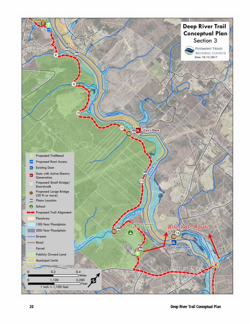
SECTION 3. CENTRAL FALLS TO CEDAR FALLS Section Distance: 3 Miles; No Completed Trail
Preferred Alignment: Southwest side or river right; Alternate Alignment: Portions on the northeast
side or river left.
Stream Crossings: 10 (Map ID 7‐50ft, 8‐25ft, 9‐20ft, 10‐17ft, 11‐12ft, 12‐35ft, 13‐20ft, 14‐45ft, 15‐360ft,
16‐30ft)
Summary: This section of trail has one
active dam, Cox’s dam. Just
downstream of Central Falls towards
Cedar Falls is publicly owned land
owned by Randolph County or
Randolph Community College. All of
the publicly owned parcels are located
on the southwest portion of the river.
The majority of the land use on the
publicly owned land is the former
landfill, which serves as a transfer
station. Another large part of the
publicly owned land has been leased
to Waste Management for an active
landfill, but provides for a 300 foot
buffer along the Deep River. As the
corridor gets closer to Cedar Falls,
topography and geology gets hillier, where bluffs along the river make it difficult to access the river from
the land adjacent on the southwest side of the river. The northeast side of the river may provide better
construction options, however there is active farming and all privately held land south of Cox’s dam on
the northeast side or river left. An alternate route has been suggested on the northeast side of the river
(river left).
Key Improvements:
Develop a public boat access and trailhead downstream from Old Liberty Road on land owned
by the City of Asheboro near the Shriner’s Club;
Design and build trail on the old and new landfill property, connecting with the RCC campus,
where a trailhead is proposed;
Explore purchase of Cedar Dam and island for park and water access;
Work with willing landowners to acquire trail easements; and
Investigate and determine feasibility of alternative trail routes to connect with Cedar Falls.
Photo 9: Deep River Near Cox's Dam
20 Deep River Trail Conceptual Plan

21 Deep River Trail Conceptual Plan
Table 4 ‐ Section 3 Photos: Central Falls to Cedar Falls
P1 – Small wetlands area downstream from Central Falls
P2 – Rock outcropping downstream from Central Falls
P3 – Cox’s Dam
P4 – Rock outcropping adjacent to Deep River and new
landfill property
P5 – Field Work at Gabriel’s Creek
P6 – Proposed trailhead adjacent to RCC training facility

22 Deep River Trail Conceptual Plan
[THIS PAGE INTENTIONALLY LEFT BLANK]
23 Deep River Trail Conceptual Plan
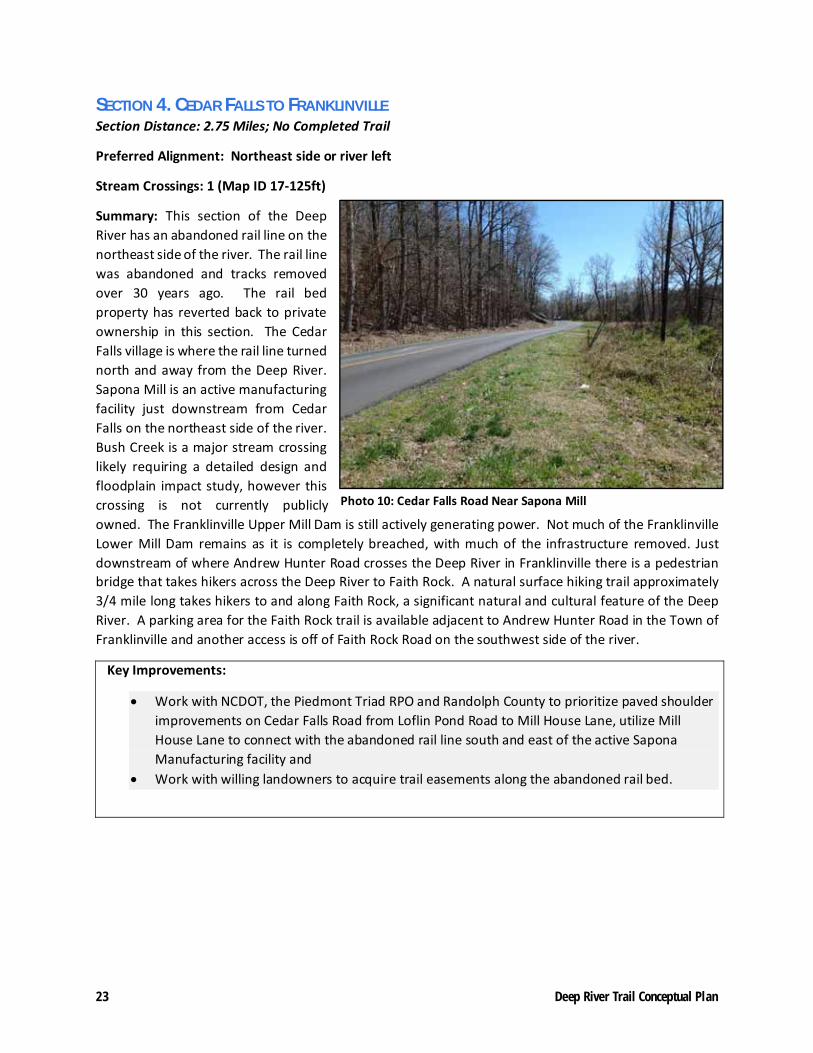
SECTION 4. CEDAR FALLS TO FRANKLINVILLE Section Distance: 2.75 Miles; No Completed Trail
Preferred Alignment: Northeast side or river left
Stream Crossings: 1 (Map ID 17‐125ft)
Summary: This section of the Deep
River has an abandoned rail line on the
northeast side of the river. The rail line
was abandoned and tracks removed
over 30 years ago. The rail bed
property has reverted back to private
ownership in this section. The Cedar
Falls village is where the rail line turned
north and away from the Deep River.
Sapona Mill is an active manufacturing
facility just downstream from Cedar
Falls on the northeast side of the river.
Bush Creek is a major stream crossing
likely requiring a detailed design and
floodplain impact study, however this
crossing is not currently publicly
owned. The Franklinville Upper Mill Dam is still actively generating power. Not much of the Franklinville
Lower Mill Dam remains as it is completely breached, with much of the infrastructure removed. Just
downstream of where Andrew Hunter Road crosses the Deep River in Franklinville there is a pedestrian
bridge that takes hikers across the Deep River to Faith Rock. A natural surface hiking trail approximately
3/4 mile long takes hikers to and along Faith Rock, a significant natural and cultural feature of the Deep
River. A parking area for the Faith Rock trail is available adjacent to Andrew Hunter Road in the Town of
Franklinville and another access is off of Faith Rock Road on the southwest side of the river.
Key Improvements:
Work with NCDOT, the Piedmont Triad RPO and Randolph County to prioritize paved shoulder
improvements on Cedar Falls Road from Loflin Pond Road to Mill House Lane, utilize Mill
House Lane to connect with the abandoned rail line south and east of the active Sapona
Manufacturing facility and
Work with willing landowners to acquire trail easements along the abandoned rail bed.
Photo 10: Cedar Falls Road Near Sapona Mill

24 Deep River Trail Conceptual Plan

25 Deep River Trail Conceptual Plan
Table 5 ‐ Section 4 Photos: Cedar Falls to Franklinville
P1 – Task force member Tom Jordan with childhood home
in the background at Cedar Falls
P2 – Old bridge structure at Cedar Falls
P3 – View of Deep River at Cedar Falls
P4 – Bush creek outlet to the Deep River
P5 – Task force members talk with a landowner
P6 – View of active Franklinville Upper Dam

26 Deep River Trail Conceptual Plan
[THIS PAGE INTENTIONALLY LEFT BLANK]

27 Deep River Trail Conceptual Plan
SECTION 5. FRANKLINVILLE TO RAMSEUR Section Distance: 2 Miles; Completed Trail: 1 Mile, Funding Pending for 1 mile of trail
Trail Alignment: Northeast side or river left
Stream Crossings: 1 (Map ID 18‐115ft)
Summary: This section begins at
Riverside Park in Franklinville. Just
downstream, much of the
Franklinville Lower Mill Dam is
completely breached with some
dam material removed. The Town
of Franklinville constructed one
mile of trail along the old rail bed.
The Town of Franklinville has
funding to complete the trail from
Sandy Creek to Riverside Park. The
crossing of Sandy Creek to Ramseur
has been an ongoing challenge to
physically connect. The old rail
crossing is over 200 feet and
alternate crossings are likely 85
feet or more.
Key Improvements:
Secure pending Recreational Trails Program grant to complete the Deep River Trail that will
connect Sandy Creek to Riverside Park in Franklinville.
Complete a proposed alignment, design and floodplain analysis of the Sandy Creek bridge in
2017 and 2018. Randolph County has provided funding for the design and additional funds to
leverage grants for construction of the bridge.
Continue to promote the existing trail and invite citizens and community leaders along the Deep
River to walk the existing trail
Photo 11: Deep River Rail Trail Sign

28 Deep River Trail Conceptual Plan

29 Deep River Trail Conceptual Plan
Table 6 ‐ Section 5 Photos: Franklinville to Ramseur
P1 – View of pedestrian bridge from Franklinville to Faith
Rock (Credit:Town of Franklinville)
P2 – Task force member and Franklinville Mayor Perry
Conner on top of Faith Rock (Credit: Town of Franklinville)
P3 – View of the Deep River from Riverside Park in
Franklinville (Credit: PTRC)
P4 – Deep River Trail at Rising Sun Way (Credit: PTRC)
P5 – Deep River Trail Users (Credit: Dilys Bowman)
P6 – Sandy Creek former railroad crossing (Credit: PTRC)

30 Deep River Trail Conceptual Plan
[THIS PAGE INTENTIONALLY LEFT BLANK]

31 Deep River Trail Conceptual Plan
SECTION 6. RAMSEUR Section Distance: 1.25 Miles; Partially completed trail between Sandy Creek & Harlan’s Creek
Trail Alignment: Northeast side or river left
Stream Crossings: 1 (Map ID 19 – 195ft)
Summary: This 1.25 mile section of
proposed trail had a detailed trail study
completed in 2011. The recommended
surface from the plan is crushed granite
millings at a width of 10 feet. Between
the trailhead at the old boat landing and
Harlan’s Creek, easements for the trail
have been acquired by the Town of
Ramseur. Surfacing material has been
placed between the old boat landing and
Harlan’s Creek to increase accessibility.
There is one major stream crossing with
rail trestle piers still in place, over
Harlan’s Creek; the decking has been
removed (see P3 photo). These piers
appear to be in good enough condition to
be reused, but will need to be analyzed by a structural engineer to determine if a pedestrian bridge could
be constructed on them. The good condition of the rail bed should require less grading/grubbing and
base material for trail construction than usual.
Key Improvements:
Acquire the final easement for trail development along the old rail bed just downstream from
Harlan’s Creek.
Secure funding for construction of the Harlan’s Creek bridge, a key connection for this section
of trail
Improve trailhead parking and signage off US 64 to create better access to the existing trail
Re‐establish a Town committee to keep the existing trail cleared and maintained.
Photo 12: Old Rail Bed Near Harlan's Creek

32 Deep River Trail Conceptual Plan

33 Deep River Trail Conceptual Plan
Table 7 ‐ Section 6 Photos: Ramseur
P1 – Old Boat Land Open Space near Sandy Creek
P2 – Old rail bed in Ramseur
P3 – Harlan’s Creek former rail crossing
P4 – Ramseur Dam
P5 – Old railbed and sewer maintenance road
P6 – View of potential trailhead at Brooklyn Avenue

34 Deep River Trail Conceptual Plan
DEEP RIVER BLUEWAY TRAIL

35 Deep River Trail Conceptual Plan
RIVER CONDITIONS AND PORTAGES Randleman Park to Worthville Dam (2.4 miles)
Level of Difficulty: Class 1
Portage: Worthville Dam, river right/southwest side
Key Improvements: Signage, access ramps/steps and trail surfacing improvements.
Worthville Dam to Cox Dam (5.8 miles)
Level of Difficulty: Flat
Portage: Cox Dam, river right/southwest side
Key Improvements: Signage, access ramps/steps, a bridge over Cox Creek, trail surfacing improvements and trail easement from private landowner.
Cox Dam to Cedar Falls/Loflin Pond Road (0.5 miles)
Level of Difficulty: Class I, II, III
Portage: Cedar Falls Dam and falls, river left/northeast side*
Key Improvements: Signage, access ramps/steps, trail surfacing improvements and trail easement from private landowner.
*Experienced paddlers may choose to float Cedar Falls below the dam, however a portage to Loflin Pond Road may be necessary for less experienced paddlers or in low water conditions.
Cedar Falls/Loflin Pond Road to Andrew Hunter Road (2 miles)
Level of Difficulty: Class I, II
Portage: Franklinville Upper Mill Dam, river left/northeast side**
Key Improvements: Signage, access ramps/steps, trails surfacing improvements and trail easement from private landowner.
**Portage will require a ¼ mile carry to get across Andrew Hunter Road
Andrew Hunter Road to US 64/Sandy Creek (2.3 miles)
Level of Difficulty: Class II
Portage: Depending on the water level, the Franklinville Lower Mill Dam may require a portage river left/northeast side, however it can be floated in most conditions.
Key Improvements: Signage and boat access improvements at Franklinville Park pedestrian bridge needed. Trail access easements needed upstream from Andrew Hunter Road.
US 64/Sandy Creek to Brooklyn Bridge (1 mile)
Level of Difficulty: Flat or Class I
Portage: Ramseur Dam, river left/northeast side
Key Improvements: Signage, access ramps/steps, trails surfacing improvements. Alternate take out above Ramseur Dam on river right/southwest side at the Leonard Memorial Park.
The blueway trail will require physical
improvements and access easements
from willing landowners where noted.
These descriptions are intended to
advise blueway trail improvements, not
to guide paddlers along the Deep River.

36 Deep River Trail Conceptual Plan
RECENT PROGRESS & ACTION STEPS
The following list shows recent strategic steps taken and actions steps for the next 12‐18 months to assist in implementation of the Deep River Trail. The Deep River Trail Task force will be instrumental in assisting with implementing the action steps listed below.
1. LAND TRAIL Randleman – Construct Phase I Trail from Randleman Park to E. Naomi St. In progress.
Randleman – Construct Phase II Trail from E. Naomi St. to Worthville Dam. Funded.
Randleman – Acquire property down stream of Worthville Dam. Complete.
Central Falls to Cedar Falls – Work with Randolph County Administration, Community College and Waste Management on trail along publicly owned property. Funding needed. Detailed trail alignment to be completed with master trail builder.
Central Falls to Cedar Falls ‐ Explore purchase of Cedar Dam and island for park and water access. Present a proposal to the Piedmont Triad Water Authority for purchase.
Franklinville – Acquire Faith Rock property and new trail to add to Riverside Park. Complete.
Franklinville – Construct segment connecting existing Deep River Rail Trail to Riverside Park. Funding requested.
Franklinville – Design and construct bridge over Sandy Creek. Construction project cost and ranking submitted to NCDOT by the Piedmont Triad RPO. Engineering study and environmental assessment and estimated 10% of bridge construction funding secured.
Ramseur – Construct Rail Trail from Boat Landing to Harlan’s Creek. Complete.
Ramseur – In partnership with State Parks, acquire parcel just downstream from Harlan’s Creek to complete easement and acquisition for trail development. In progress.
2. BLUEWAY
Improve small boat access at Worthville Dam and implement Central Falls small boat access. Design boat landings and complete environmental analysis for floodplain impact.
Hold a historical barge and boat regatta between Worthville and Central Falls to highlight the
former company ships that ran between mills. Present idea to Randolph Historical Society for
input and partnership.
Cedar Falls/Loflin Pond Rd to Andrew Hunter Rd. Work on access location.
Andrew Hunter Rd to Franklinville Park. Work on access.
River clean‐ups on different sections of the river. Conduct spring and fall clean up events.
Implement portage improvements around dams. Seek grant funding for dam portage trail improvements and seek easements from willing landowners where required.
3. ENVIRONMENTAL STEWARDSHIP Continue Stormwater education programs in schools through Stormwater SMART. Partner with
Stormwater SMART, a stormwater education program.

37 Deep River Trail Conceptual Plan
Continue river clean‐ups for different sections of the Deep River. Partner with Keep Randolph
County Beautiful, Waste Management and other civic partners.
Explore the establishment of a Deep Riverkeeper program to organize river clean‐ups, advocate
for river health & rehabilitation. Establish public/private partnership with existing
organizations.
4. MAINTENANCE Continue to share best practices for maintenance between each town and participate in trail
conferences to develop new techniques and innovations. Participate in Piedmont Legacy Trails
annual conference and resolution of support.
Conduct and share trail counts and surveys to understand how people are using the developing
Deep River trail. Provide comment request forms at trailheads to allow feedback on trail
improvements.
Provide information to trail users on how to report maintenance issues along trail sections.
Establish mile markers or other location information, share and coordinate with Randolph
County EMS and local law enforcement.