oregon trail scenic byway - bureau of land management · island crossing state park interpretive...
TRANSCRIPT

Oregon TrailScenic Byway
Three Island Crossing
to Bonneville Point
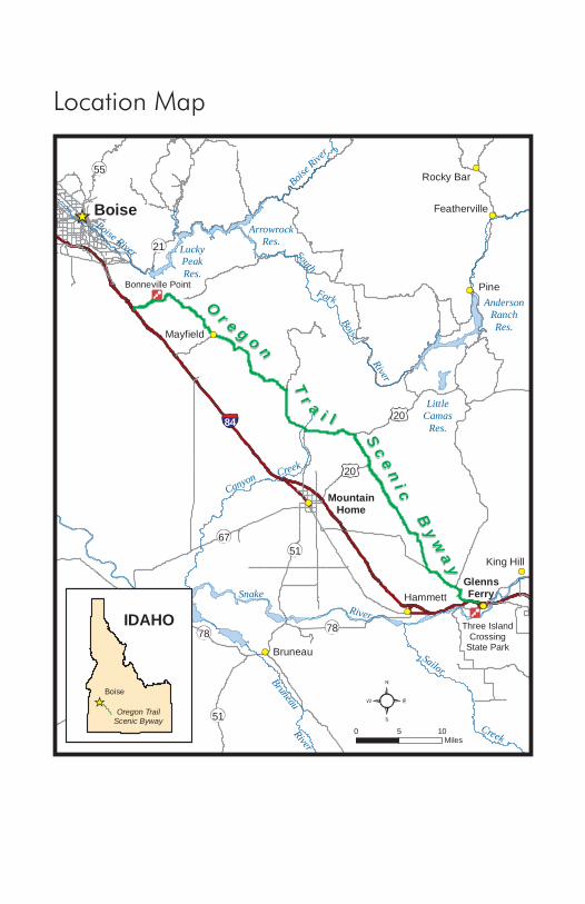
Location Map
Bonneville Point
Three IslandCrossing
State Park
Boise
MountainHome
GlennsFerry
Grand View
Pine
Bruneau
Hammett
Mayfield
King Hill
Rocky Bar
Featherville
Canyon Creek
River
Bruneau
SnakeRiver
Creek
Sailor
AndersonRanchRes.
LittleCamas
Res.
South
LuckyPeakRes.
ArrowrockRes.
Boise River
Boise R
iver
Fork
Boise
River
84 20
6751
51
78 78
21
55
20
Or e g o n
Or e g o n
Tr a i l
Tr a i l
Sc
en
i c
Sc
en
i cB
yw
ay
By
wa
y
0 105Miles
Oregon TrailScenic Byway
Boise
IDAHO
(Overview)
1
Oregon TrailScenic Byway
Three Island Crossing
to Bonneville Point
This publication was developed as a cooperative project of the Idaho Chapter of the Oregon-California Trails Association (IOCTA) and the Bureau of Land Management (BLM). Writing and photos were provided by Jerry Eichhorst, IOCTA. Maps, editing, additional photos and design were provided by the Bureau of Land Management.
The IOCTA organization is dedicated to education about, preservation, and enjoyment of the emigrant trails through Idaho. Primary activities are trail marking in conjunction with the Bureau of Land Management, National Park Service, and US Forest Service, and trail outings where knowledgeable members lead expeditions on trail segments. For more information on the Oregon Trail in Idaho, please visit the website at www.idahoocta.org.
2
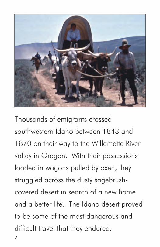
Thousands of emigrants crossed
southwestern Idaho between 1843 and
1870 on their way to the Willamette River
valley in Oregon. With their possessions
loaded in wagons pulled by oxen, they
struggled across the dusty sagebrush-
covered desert in search of a new home
and a better life. The Idaho desert proved
to be some of the most dangerous and
difficult travel that they endured.

3
The main Oregon Trail from Three Island Crossing to Boise was the primary route utilized by the emigrants for the first 10 years of the trail. Those emigrants who could not cross the Snake River were forced to follow the south side of the Snake River on a route known as the South Alternate. Freight and stage roads to the railroad in northern Utah utilized much of the Oregon Trail for many years. The Oregon Trail continued to be used long after the building of the railroads across southern Idaho, even into the early 1900’s.
The Oregon Trail Scenic Byway follows the main Oregon Trail from the crossing of the Snake River near Glenns Ferry to Bonneville Point, southeast of Boise. Part 1 of the byway is a loop drive that takes you to the south side of the Snake River to view the Three Island Crossing location from the bluffs above the river, then ends on the north side of the river at Three Island Crossing State Park interpretive center. Parts 2 and 3 take county roads to follow the Oregon Trail from Glenns Ferry to Bonneville Point. Oregon Trail ruts are visible along much of this route. Several locations allow access for hiking and horseback riding on the Oregon Trail.
The total distance of the byway is 89 miles. Allow eight hours to complete the trip from Boise, including time to visit the Three Island Crossing State Park interpretive center and to explore the Oregon Trail at the various access points along the way. All of the byway roads are paved or good gravel roads. High clearance vehicles may be required to access the trail off the byway. Four-wheel drive is not needed for the byway, but please stay off the access roads if they are wet or muddy.
The byway is separated into three parts – The Snake River and Three Island Crossing State Park, Snake River to Rattlesnake Creek, and Rattlesnake Creek to Bonneville Point. Highway 20 bisects the byway at Rattlesnake Creek and provides access to Mountain Home and Interstate 84.
4
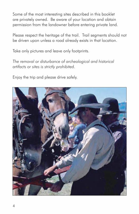
Some of the most interesting sites described in this booklet are privately owned. Be aware of your location and obtain permission from the landowner before entering private land.
Please respect the heritage of the trail. Trail segments should not be driven upon unless a road already exists in that location.
Take only pictures and leave only footprints.
The removal or disturbance of archeological and historical artifacts or sites is strictly prohibited.
Enjoy the trip and please drive safely.

5
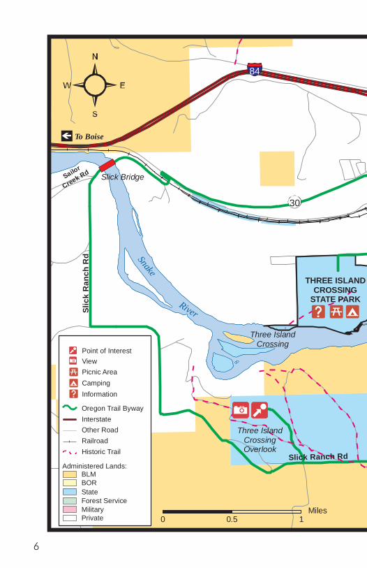
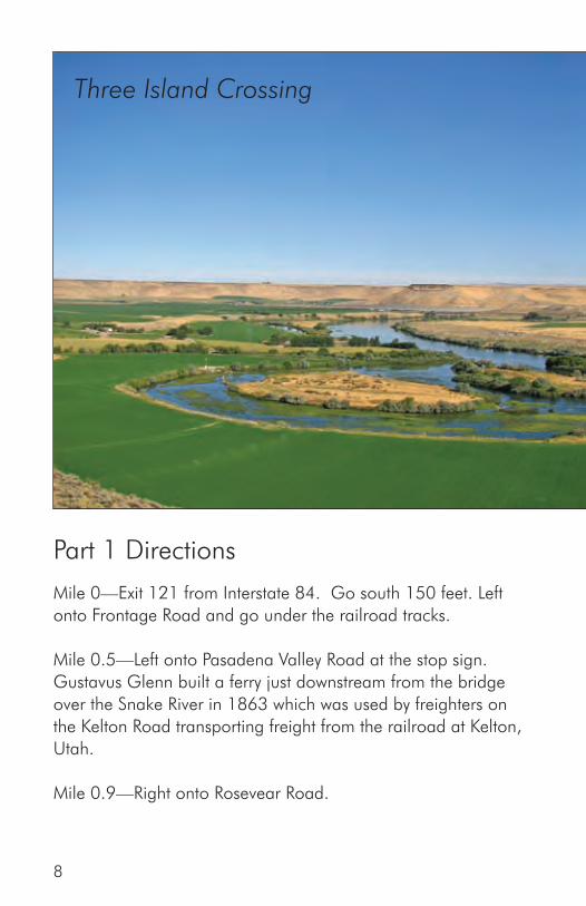
Part 1The Snake River and
Three Island Crossing State Park
After leaving the Snake River at Salmon Falls, the Oregon Trail emigrants crossed nearly 30 miles of desert without direct access to water for two days. They were then confronted with the often dangerous task of crossing the Snake River. Those who feared to cross were forced to continue down the south side of the Snake River over a rough and dry route known as the South Alternate.
Part 1 of the Oregon Trail Scenic Byway is a short loop drive which will take you to the primary location which was used for this crossing. A stop may be made on the bluff overlooking the site of Three Island Crossing where interpretive signs are available. This drive will also take you to the Three Island Crossing State Park interpretive center on the north side of the Snake River.
The Oregon Trail Scenic Byway Snake River and Three Island Crossing State Park Route begins at Exit 121 on Interstate 84. This is the eastern exit for Glenns Ferry. This point will be mile 0 for the Snake River and Three Island Crossing State Park driving guide. All services are available in Glenns Ferry.
Exit 120
Snake
River
84
Rosevear R
d
Rose
vear
Rd
Slic
k R
anch
Rd
Slick Bridge
30
1st Ave
Com
mercial St
Exit 121
Ban
nock
Ave
Frontage RdPasadena Valley Rd
Sailor
Creek Rd
To Boise
To Twin Falls
GLENNS FERRY
THREE ISLANDCROSSING
STATE PARK
Three IslandCrossingOverlook
Three IslandCrossing
Two IslandCrossing
Rosevear Gulch
START
END
(Part 1)
Madison Ave
Slick Ranch Rd
Point of InterestViewPicnic AreaCampingInformation
Oregon Trail Byway InterstateOther RoadRailroadHistoric Trail
Administered Lands:
State
MPrivate
ilitaryForest Service
BORBLM
0 10.5Miles
6

Exit 120
Snake
River
84R
osevear Rd
Rose
vear
Rd
Slic
k R
anch
Rd
Slick Bridge
30
1st Ave
Com
mercial St
Exit 121
Ban
nock
Ave
Frontage RdPasadena Valley Rd
Sailor
Creek Rd
To Boise
To Twin Falls
GLENNS FERRY
THREE ISLANDCROSSING
STATE PARK
Three IslandCrossingOverlook
Three IslandCrossing
Two IslandCrossing
Rosevear Gulch
START
END
(Part 1)
Madison Ave
Slick Ranch Rd
Point of InterestViewPicnic AreaCampingInformation
Oregon Trail Byway InterstateOther RoadRailroadHistoric Trail
Administered Lands:
State
MPrivate
ilitaryForest Service
BORBLM
0 10.5Miles
7
Part 1 Directions
Mile 0—Exit 121 from Interstate 84. Go south 150 feet. Left onto Frontage Road and go under the railroad tracks.
Mile 0.5—Left onto Pasadena Valley Road at the stop sign. Gustavus Glenn built a ferry just downstream from the bridge over the Snake River in 1863 which was used by freighters on the Kelton Road transporting freight from the railroad at Kelton, Utah. Mile 0.9—Right onto Rosevear Road.
Three Island Crossing
8
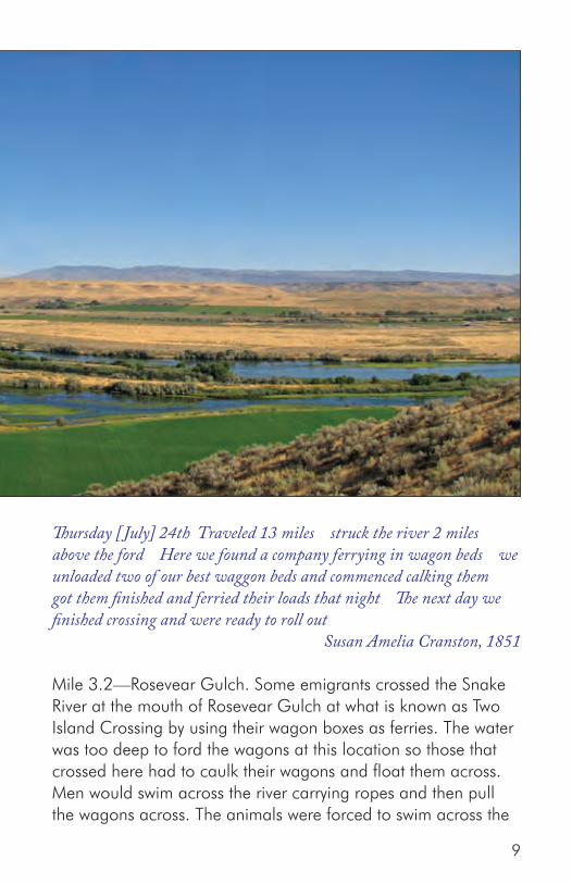
Thursday [ July] 24th Traveled 13 miles struck the river 2 miles above the ford Here we found a company ferrying in wagon beds we unloaded two of our best waggon beds and commenced calking them got them finished and ferried their loads that night The next day we finished crossing and were ready to roll out Susan Amelia Cranston, 1851
Mile 3.2—Rosevear Gulch. Some emigrants crossed the Snake River at the mouth of Rosevear Gulch at what is known as Two Island Crossing by using their wagon boxes as ferries. The water was too deep to ford the wagons at this location so those that crossed here had to caulk their wagons and float them across. Men would swim across the river carrying ropes and then pull the wagons across. The animals were forced to swim across the
9
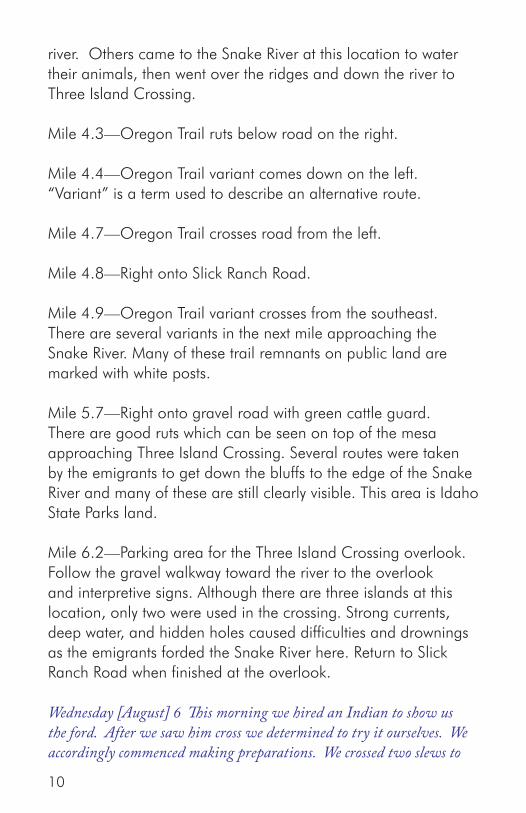
river. Others came to the Snake River at this location to water their animals, then went over the ridges and down the river to Three Island Crossing. Mile 4.3—Oregon Trail ruts below road on the right.
Mile 4.4—Oregon Trail variant comes down on the left. “Variant” is a term used to describe an alternative route.
Mile 4.7—Oregon Trail crosses road from the left.
Mile 4.8—Right onto Slick Ranch Road.
Mile 4.9—Oregon Trail variant crosses from the southeast. There are several variants in the next mile approaching the Snake River. Many of these trail remnants on public land are marked with white posts.
Mile 5.7—Right onto gravel road with green cattle guard. There are good ruts which can be seen on top of the mesa approaching Three Island Crossing. Several routes were taken by the emigrants to get down the bluffs to the edge of the Snake River and many of these are still clearly visible. This area is Idaho State Parks land.
Mile 6.2—Parking area for the Three Island Crossing overlook. Follow the gravel walkway toward the river to the overlook and interpretive signs. Although there are three islands at this location, only two were used in the crossing. Strong currents, deep water, and hidden holes caused difficulties and drownings as the emigrants forded the Snake River here. Return to Slick Ranch Road when finished at the overlook.
Wednesday [August] 6 This morning we hired an Indian to show us the ford. After we saw him cross we determined to try it ourselves. We accordingly commenced making preparations. We crossed two slews to
10
the second island. Here we put ox yokes under the wagon loads to raise them, and put four yoke of our best oxen to each of the four first wagons that crossed. These four got over safely. We then sent the teams back to fech the other three wagons. These three we got over safe. The loose cattle was to fech. These cattle were to be took to the upper end of the second island. They were soon swimming water and swam to the sholes where the wagons crossed on. Suffice it to say we all got over, our cattle and all safely. This ford is about 3/4 of a mile long, and runs up the river. This day was warm and still.
Robert Haldane Renshaw, 1851
Mile 6.8—Turn right onto Slick Ranch Road.
Mile 8.2—Good view of Three Island Crossing upstream. Oregon Trail variant is clearly visible winding down ridge to the right.
Mile 10.1—Turn right onto Sailor Creek Road at the stop sign. Cross the Snake River on Slick Bridge.
Mile 10.7—Cross the railroad tracks and turn left.
Mile 10.8—Turn right onto Highway 30 at the stop sign.
Mile 12.4—Turn right onto 1st Avenue just before the hamburger stand and continue through downtown Glenns Ferry.
Mile 13.0—Turn right onto Commercial Street.
Mile 13.5—Turn right onto Madison.
Mile 14.5—Turn left into Three Island Crossing State Park. There is a small fee to enter the park. Idaho’s state park dedicated to the Oregon Trail contains an interpretive center and large full-hookup campground. Oregon Trail ruts are visible between the river and the interpretive center. A reenactment
11

of the emigrant crossing of the Snake River occurs the second Saturday of August each year. Additional information about the park may be found at www.stateparks.com/three_island_crossing.html.
Mile 15.0—Interpretive Center. The interpretive center shows a film about the Oregon Trail. It has excellent displays and a gift shop.
Mile 17.1—Return to 1st Avenue in downtown Glenns Ferry by turning right onto Madison and left onto Commercial. If you do not wish to continue on the byway, turn right (east) onto 1st Avenue to proceed to Interstate 84 with eastbound and westbound access. Turn left (west) onto 1st Avenue to continue with Part 2 of the Oregon Trail Scenic Byway. Westbound access to Interstate 84 is also available.
Mile 17.4—Turn right onto Bannock Street.
Mile 18.0—Go under Interstate 84. Continue with the driving directions for Part 2 of the Oregon Trail Scenic Byway.
12

Part 2Snake River to Rattlesnake Creek
After crossing the Snake River, the emigrants climbed out of the Snake River canyon and proceeded across the desert to the northwest. The route was rough and dusty, but small streams were available every few miles to provide water and camping locations. Near the end of this section, the emigrants passed one of the more interesting sites of their journey, the hot springs at the base of Teapot Dome.
This drive will closely follow the Oregon Trail and allow access for hiking at several locations. Excellent ruts still exist for much of this section on public lands.
The Oregon Trail Scenic Byway Snake River to Rattlesnake Creek route begins at the east end of Old Oregon Trail Road, just north of Exit 120 on Interstate 84. This is the western exit for Glenns Ferry. Interstate 84 does not have a westbound exit here so westbound travelers must exit at Exit 121 and travel through Glenns Ferry and then north to this location. This point will be mile 0 for the Snake River to Rattlesnake Creek driving guide. All services are available in Glenns Ferry. There are no services available on this section of the scenic byway.
13

Part 2 Map A
Alkal
i Cre
ek
Cold Sp
rings
Cre
ek
Snake Riv er
Rye grass Creek
84 Exit 120
Old Oregon Trail Rd
Ben
nett
Mou
ntai
n R
d
Wal
ker R
d
Ryegrass R
d
Ross Rd
Exit 114
THREEISLAND
CROSSINGS. P.
START
CONTINUED ONNEXT MAP
GLENNS FERRY
North Alternate Oregon Trail
Oregon Trail
South Alternate Oregon Trail
0 21Miles
(Part 2: First Stretch)
Administered Lands:Oregon Trail Byway RouteInterstateOther RoadRailroadHistoric Trail
Point of InterestViewPicnic AreaCampingInformation
State
MilitaryForest Service
Bureau of ReclamationBureau of Land Management
Private
14

Part 2 Directions
Mile 0—Turn left onto Old Oregon Trail Road.
Mile 1.2—The Oregon Trail crosses at this location. After crossing the Snake River, emigrants could follow Little Canyon Creek upstream to the north or continue to the northwest on the route here. After a few miles, the variants joined and the trail climbed out of the Snake River canyon. Turn right and follow the dirt road which is the route of the Oregon Trail 1/2 mile to the north for access to the trail. Excellent ruts are still visible climbing the side of a gully to the top of the mesa. Multiple swales climb the hill to the west. This is a good area for hiking.
Thur Aug 14 ...We had a squally time ascending the bluffs, which are severaly hundred feet high. We passed from a hill to the side of a bluff, upon a high narrow ridge of just sufficient width upon the top for the wagon road, the sides descending very steep each way. Just as the wagons were upon this a gale of wind in advance of a thunder shower struck us, and blew with such violence directly across the track that it seemed as if the wagons, teams and all would be blown away. James Field, 1845
Mile 2.4—Return to Old Oregon Trail Road and turn right.
Mile 5.0—Right onto Bennett Mountain Road
Mile 5.5—The Oregon Trail crosses at this location. Turn around. The trail on both sides of Bennett Mountain Road is available for hiking and contains some good ruts.
Mile 6.0—Return to Old Oregon Trail Road and turn right.
Mile 7.2—Alkali Creek. The Oregon Trail crossed the creek 15

about a mile to the north. Alkali Creek was a common camping area after crossing the Snake River. A narrow canyon with a small stream in a good year, grass was often limited in this area. There are ruts remaining on both sides of the creek on public land.
[Sept] 15 layed by this morning one company moved on except one family the woman got mad and would not budge nor let the children he had his cattle hitched on for 3 hours and coaxing her to go but she would not stur I told my husband the circumstance and him and Adam Polk and Mr Kimble went and took each one a young one and cramed them in the wagon and her husband drove off and left her siting she got up took the back track travled out of sight cut a cross overtook her husband meantime he sent his boy back to camp after a horse that he had left and when she came up her husband says did you meet John yes was the reply and I picked up a stone and nocked out his brains her husband went back to asertain the truth and while he was gone she set one of his waggons on fire which was loaded with store goods the cover burnt off and some valueable artickles he saw the flame and came runing and put it out and then mustered spunk enough to give her a good floging her name is Marcum She is cousin to Adam Polks wife [Note: The son, John, was not hurt by his mother.]
Elizabeth Dixon Smith, 1847
Mile 8.8—Turn right onto Walker Road
Mile 9.8—Access to the Oregon Trail is available on the south side of the fence 200 feet east of the road at this location. Some ruts are visible to the southeast. Turn around.
Mile 10.8—Return to Old Oregon Trail Road and turn right.
Mile 11.3—Cold Springs Creek. The Oregon Trail crossed the creek about a mile to the north. This creek was another popular camping spot. It often had water and grass when other areas were dry. The Cold Springs Creek crossing and adjacent ruts are
16
located on private property and are not available for viewing.
August 3 This morning, after traveling a short distance, we came to a small creek, which in attempting to cross, my wagon tongue got fractured, which detained us for an hour... P. V. Crawford, 1851
Mile 12.0—Turn right onto Ryegrass Road.
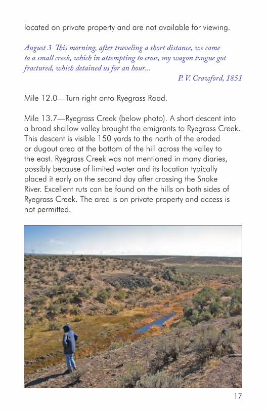
Mile 13.7—Ryegrass Creek (below photo). A short descent into a broad shallow valley brought the emigrants to Ryegrass Creek. This descent is visible 150 yards to the north of the eroded or dugout area at the bottom of the hill across the valley to the east. Ryegrass Creek was not mentioned in many diaries, possibly because of limited water and its location typically placed it early on the second day after crossing the Snake River. Excellent ruts can be found on the hills on both sides of Ryegrass Creek. The area is on private property and access is not permitted.
17
Administered Lands:Oregon Trail Byway RouteInterstateOther RoadRailroadHistoric Trail
Point of InterestViewPicnic AreaCampingInformation
State
MilitaryForest Service
Bureau of ReclamationBureau of Land Management
Private
Part 2 Map B
Ben
nett
Cre
ek
Hot Spring s Creek
Rattlesnake Cr
Ross Rd
Wilson Rd
Teapot Rd
Ross Rd
Teapot Rd
20
END
Kelton Road
North Alternate Oregon Trai l
Oregon Trail
0 21Miles
(Part 2: Second Stretch)
18
Friday [August] 8 Left the branch above mentioned, and traveld about six miles to a branch and nooned. Plenty of good grass at these branches...
Robert Haldane Renshaw, 1851
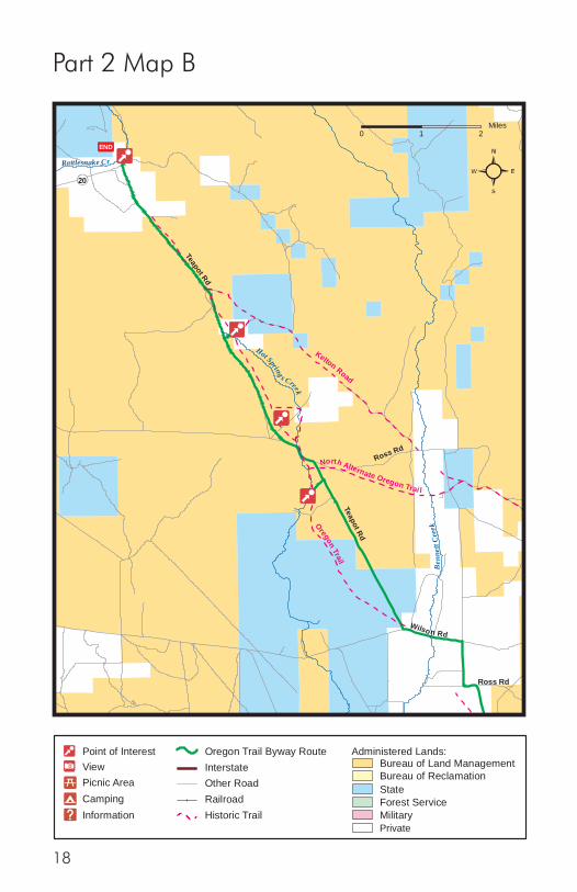
Mile 15.5—Turn left at the intersection with Ross Road. One variant of the Oregon Trail crossed through this intersection.
Mile 16.4—Turn left onto Wilson Road.
Mile 16.9—Bennett Creek. The Oregon Trail crossed the creek just south of where the road crosses the creek today then continued through the ranch area and towards Teapot Dome. Bennett Creek was a steady source of water for the emigrants. When other streams were dry, Bennett Creek had water available. The Bennett Creek crossing is now on private property and most of the trail remnants have been erased due to many years of farming and ranching.
August 3 ...Five miles farther over a sage plain brought us to a very nice spring branch, with plenty of grass and willow… P. V. Crawford, 1851
Mile 17.4—Turn right onto Teapot Road. The Oregon Trail went through this intersection and ruts can be hiked to the west.
Mile 20.2—Access to the trail is available by turning left onto the dirt road for 200 yards.
There are excellent ruts which are visible along the east side of Hot Springs Reservoir and the creek.
Sunday [ July] 27 Traveled 15 miles 5 miles brought us to a marshy hollow which wound to right of the direction were traveling Traveled in this marsh 3 miles then drove out leaving this marsh to our right... Susan Amelia Cranston, 1851
19

Mile 20.7—Return to Teapot Road and turn left.
Mile 20.9—North Alternate Junction. In the 1850’s, the North Alternate Oregon Trail route was created. This route crossed the Snake River south of Hagerman and proceeded across the desert to join the main trail at Hot Springs Creek near this location. Ruts may be seen coming down the hill to the southeast of the intersection of Ross Road.
Mile 21.0—Turn left at the intersection of Ross Road.
Mile 21.1—Oregon Trail crosses from the left.
Mile 21.2—Hot Springs Creek. A few miles of flat sagebrush covered trail brought the emigrants to Hot Springs Creek. The water was often described as being dark, marshy, and not good, although the grass in the valley was generally good. The trail followed up the east side of the creek for a few miles, then crossed the creek and climbed out of the valley.
Mile 21.5—Oregon Trail visible climbing out of Hot Springs Creek valley in the gully to the right of the road.
Mile 21.7 to 23.1—Oregon Trail ruts can be found close to Teapot Road on the north side. They are available for hiking and horseback riding.
Mile 23.6—Turn right onto the dirt road for 200 yards for access to the Hot Springs site.
The Hot Springs site is a short distance north of Teapot Road on a dirt road. The area beyond the fence including the bathhouse site is private property.
Mile 23.7—Hot Springs. These springs were mentioned by nearly every diarist. The water rose out of several springs in close
20

proximity to cold springs. The water was hot enough to cook fish and eggs, or scald people and animals which approached too closely. Irrigation wells caused the springs to go dry many years ago so all that remains are the dry channels of where the hot springs once were.
Mile 24.2—Oregon Trail crosses Teapot Road from the right.
Mile 24.7—Kelton Road (above photo). The Kelton Road joins the Oregon Trail at this location from the northeast. When the transcontinental railroad was completed across northern Utah in 1869, roads were built to haul goods and passengers from stops along the railroad to Boise. The Kelton Road was the most popular. It started in Kelton, Utah, crossed the Snake River on a ferry southeast of Hagerman and followed much of the North Alternate Oregon Trail route. It branched away from the North
21

Alternate Oregon Trail near Bennett Creek and rejoined the main Oregon Trail route at this location. When Gustavus Glenn started his ferry across the Snake River above Three Island Crossing, the route was changed to use the ferry which avoided the very steep King Hill section. Excellent ruts of both the Oregon Trail and Kelton Road remain in this area.
Mile 25.1 to 26.2—The Oregon Trail parallels Teapot Road and ruts are visible on the north side of road.
Mile 27.2—Intersection with Highway 20. Turn right for 200 yards.
Mile 27.3—Turn left into highway historical marker sign pullout. The crossing of Rattlesnake Creek was located a short distance downstream from this location (photo on right).
Rattlesnake Creek was another dependable source of water and a common campsite for the emigrants. The creek appears to have been surrounded by willows at the time, much as it is today. A number of graves along the creek were mentioned by some diarists.
Rattlesnake Station was a stage and freight stop at this location in later years. It was renamed to Mountain Home and the townsite was eventually moved south into the valley along the railroad tracks as freight and stage traffic disappeared.Access to the trail is not allowed as private homes now surroundthe creek. Traces of the freight road to Rocky Bar can be seen north of the historical marker signs and further up the canyon. The remains of the round rock fort built in 1878 and the old school house built in 1898 may still be seen in the area.
Friday, Sept. 10 ...Traveled along the foot of the mountains about 5 miles to another creek and stopped for the night. Plenty of dry bunchgrass. No timber, but willows and sage. Found eight graves here.
22

Made fifteen miles. Parthenia Blank, 1852
To continue with Part 3 of the byway, turn left (north) onto Highway 20. To return to Mountain Home and Interstate 84, turn right (south) onto Highway 20 (8 miles).
23

Rattlesnake Creek
Mud
Sp
ring
s Cr
Canyon C
reek
20
20
20
Immigran t Rd
Syrup C
reek
Rd
Can
yon
Cre
e k R
dMayfield Rd
START
CONTINUED ONNEXT MAP
CanyonCreekStation
Oregon Trail
Kelton Road
0 21Miles
(Part 3: First Stretch)
Private
24
Rattlesnake Creek
Mud
Sp
ring
s Cr
Canyon C
reek
20
20
20
Immigran t Rd
Syrup C
reek
Rd
Can
yon
Cre
e k R
d
Mayfield Rd
START
CONTINUED ONNEXT MAP
CanyonCreekStation
Oregon Trail
Kelton Road
0 21Miles
(Part 3: First Stretch)
Private
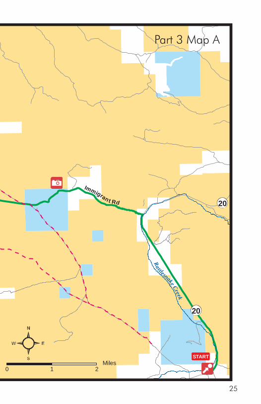
Part 3 Map A
25

Part 3Rattlesnake Creek to Bonneville Point
After crossing Rattlesnake Creek, the emigrants continued across the desert along the base of the foothills. The route was rocky for a few miles then became quite smooth. It wound through the hills and valleys, crossing several small creeks along the way. Near the end of this section, the emigrants reached the top of a ridge providing a view of the Boise River valley.
The roads followed on this drive will closely follow the Oregon Trail. Much of the trail through this section is located on private property and is not available for hiking. Many of the ruts through this area have been erased over time due to road building and ranching activities.
The Oregon Trail Scenic Byway Rattlesnake Creek to Bonneville Point route begins at the historical marker sign pullout on the west side of Highway 20, 8 miles north of I-84. This point will be mile 0 for Part 3 of the byway driving guide. There are no services available on this section of the byway.
26

Part 3 Directions
Mile 0—From the historical marker sign pullout on Highway 20, turn north (left) onto Highway 20.
Mile 3.8—Immigrant Road. Turn left onto Immigrant Road. This is a narrow dirt road which follows the route of a toll road for freight traffic heading for the Rocky Bar area mines. The original toll road is still visible in several places.
Mile 5.9—Scenic overlook.
Mile 6.6—Kelton Road. The Kelton Road crosses from the left at this point as it branched to the north to avoid a particularly rough section of the Oregon Trail.
Mile 7.95—Connecting route between the Oregon Trail and the Kelton Road crosses Immigrant Road at this point.
Mile 9.1—Rocky Road. A rocky section of the Oregon Trail can be found to the south of Immigrant Road. The portion of the trail east of Canyon Creek was noted in many diaries as some of the roughest trail that the emigrants had encountered. This section consisted of 12 miles without water, the last few miles of which were littered with volcanic rocks. The Kelton Road skirted this section to the north.
Excellent ruts still remain in this area about 100 yards to the south and are available for hiking. The area is very rocky and rough. Caution should be used to prevent foot and ankle injuries.
Sun Aug. 17 …The road this day was one of the most stoney we have yet passed over being the same iron like stones we have spoken of before crossing over Snake River. James Field, 1845
27
Mile 9.3—Oregon Trail crosses road from the left.
Mile 9.9—Turn left at the intersection with Syrup Creek Road for one hundred yards.
Mile 10.0—Turn right onto Canyon Creek / Mayfield Road.
Mile 10.2—Oregon Trail crosses from the right.
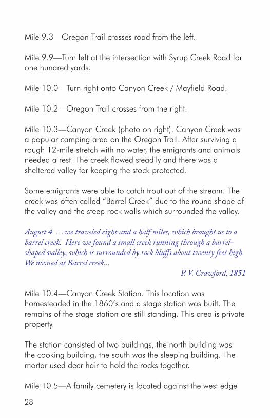
Mile 10.3—Canyon Creek (photo on right). Canyon Creek was a popular camping area on the Oregon Trail. After surviving a rough 12-mile stretch with no water, the emigrants and animals needed a rest. The creek flowed steadily and there was a sheltered valley for keeping the stock protected.
Some emigrants were able to catch trout out of the stream. The creek was often called “Barrel Creek” due to the round shape of the valley and the steep rock walls which surrounded the valley.
August 4 …we traveled eight and a half miles, which brought us to a barrel creek. Here we found a small creek running through a barrel-shaped valley, which is surrounded by rock bluffs about twenty feet high. We nooned at Barrel creek... P. V. Crawford, 1851
Mile 10.4—Canyon Creek Station. This location was homesteaded in the 1860’s and a stage station was built. The remains of the stage station are still standing. This area is private property.
The station consisted of two buildings, the north building was the cooking building, the south was the sleeping building. The mortar used deer hair to hold the rocks together.
Mile 10.5—A family cemetery is located against the west edge
28
of the valley. This area is private property.[Sept.] 4 . . . Barrel Creek about 8½ miles a bluff on both sides. 10 feet wide 1 foot deep. some grass in its bottom & plenty dry grass not far off on the bluffs sage & willows for fuel Camped here The road in reaching this creek is rocky in places.
Rev. John McAllister, 1852
29

The Kelton Road crossed Canyon Creek a mile upstream. Extensive rock work was required to make a trail out of the canyon on both sides of the creek. Excellent ruts remain in this area along the Kelton Road.
Mile 10.7—Oregon Trail crosses from the left. Excellent ruts are available for hiking to the north of the road.
Mile 14.2—Mud Springs Creek. Mud Springs was a small spring with limited water and grass. The road changed from being rocky to smooth in this area. The area was not a common camping site because of its close proximity to Canyon Creek. The Kelton Road rejoined the Oregon Trail in this area. This area is private property.
Saturday [August] 6th ...Have camped near too [two] Springs in rather a barren spot. The road all day has been dreadful rough, and I feel glad to get a place to set down and be quiet. We have passed during the last week a great many dead cattle and almost every place we have camped vs have found parts or whole waggons. We have been fortunate thus far.
Charlotte Emily Stearns Pengra, 1853
Mile 15.5—Site of a CCC camp from the 1930’s on the right.
Mile 15.6—Oregon Trail crosses from the right.
Mile 15.8—Intersection of Danskin Lookout Road. Turn left.
Mile 16.5—Oregon Trail is beside the road on the left.
Mile 17.0—Oregon Trail crosses from the left.
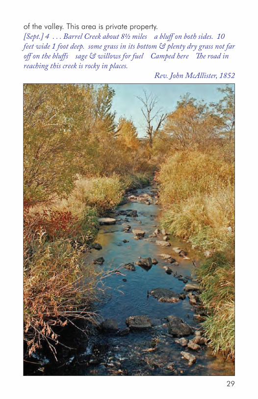
Mile 17.9—Dry Creek (photo on right). The Oregon Trail followed down Dry Creek for a short distance before turning to the right and climbing out of the valley and over the ridge
30
to Ditto Creek. The creek was generally dry although some emigrants found water further downstream. Much of this area is private property.
Saturday, Sept. 28 A fine, clear morning. Started early and nooned on a dry branch. Plenty of grass but no water. Our travel for the last two days has been along and around a mountain. The road, exceedingly rough and rocky at first, became gravelly and smoother, but very hilly...
Rev. Edward Evans Parrish, 1844
Mile 18.3—Oregon Trail turns up the gully to the right and
31

Dry Cree
k
India
n Creek
Da
nski
n Lo
okou
t Rd
Baseline Rd
Bow
ns Cree k Rd
Cemetery Rd
84
Mayfield Rd
CONTINUED ONNEXT MAP
Ditto StationSite
Mayfield Site/Stage Station
Oregon Trail
Jeffrey-Goo dale Cutof f
Bowns C re
ek
Soles Rest
Creek
Ditt
oC
reek
Rd
Ditt
oC
reek
0 21Miles
Private
32

Dry Cree
k
India
n C
reek
Da
nski
n Lo
okou
t Rd
Baseline Rd
Bow
ns Cree k Rd
Cemetery Rd
84
Mayfield Rd
CONTINUED ONNEXT MAP
Ditto StationSite
Mayfield Site/Stage Station
Oregon Trail
Jeffrey-Goo dale Cutof f
Bowns C re
ek
Soles Rest
Creek
Ditt
oC
reek
Rd
Ditt
oC
reek
0 21Miles
Private
Part 3 Map B
33

climbs the ridge.Mile 20.1—Ditto Creek overlook.
Mile 20.5—Ditto Creek. The landscape changes to include large granite boulders and more grass on the hillsides before the trail drops down and crosses the narrow Ditto Creek valley. The crossing of Ditto Creek was often noted because the creek was nearly dry. Pools of water could be found by moving up or down stream. Some of the emigrants wrote their names in axle grease on the boulders they passed. A well-worn Indian trail towards Camas Prairie went up the valley. Another emigrant route known as the Jeffrey-Goodale Cutoff crossed the Snake River near Fort Hall and traveled across the Camas Prairie before it joined the main trail here.
The trail climbs another ridge before descending into Soles Rest Creek. Good ruts can be seen in this area, however, much of this area is private property.
Mon. [October] 9th ...This evening yellowish granite appeared in needle form fragments and masses. Country mountainous, good grass, water in the creek on which we are camped partially dried up. We struck a large and much travelled Banak trail today.
Theodore Talbot, 1843
Mile 21.0—Intersection of Ditto Creek Road. Stay to the right.
Mile 21.7—Intersection of Baseline Road. Stay to the right.
Mile 22.1—Ditto Station site is on the right near the trees ½ mile in the distance. The Ditto stage station was built along Soles Rest Creek in later years. This area is on private property.
Mile 22.2—Soles Rest Creek. This creek was often dry when the emigrants came through the area. Some diary accounts mention an Indian massacre in this area. A variant of the Jeffrey-Goodale
34
cutoff rejoined the Oregon Trail at Soles Rest Creek.
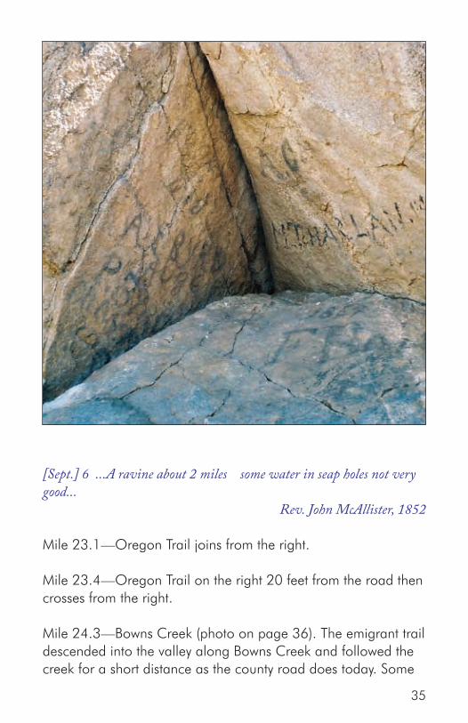
[Sept.] 6 ...A ravine about 2 miles some water in seap holes not very good...
Rev. John McAllister, 1852
Mile 23.1—Oregon Trail joins from the right.
Mile 23.4—Oregon Trail on the right 20 feet from the road then crosses from the right.
Mile 24.3—Bowns Creek (photo on page 36). The emigrant trail descended into the valley along Bowns Creek and followed the creek for a short distance as the county road does today. Some
35

diaries mention the remains of wagons near the pillar of rocks south of the road. Emigrant names may be viewed on some of the granite boulders in the area. This area is private property.
[Sept.] 6 ...A running branch about 1¾ the spring is ¼ mile right of road up the branch water tasts of sulphur willows on branch & bottom nearly 1 mile then turn to the right up a hollow...
Rev. John McAllister, 1852
Mile 24.5—Rock with emigrant names on the right.
Mile 24.8—Site of burned wagons near rock on left.
Mile 25.1—Bowns Creek Road. Stay to the right.
Mile 27.8—Cemetery Road and Indian Creek. Indian Creek crossed the trail in a large flat valley with good grass. This was often the first good water in several days. A cemetery sits on thebluff above town.
36
[Sept.] 6 ...Sharlotts creek about 3 miles this is a small creek but affords plenty water willows for fuel plenty dry grass keep down this creek ¾ mile some water may be found dry grass and willows plenty. Camped here
Rev. John McAllister, 1852
Mile 27.9—Stage station. The rock stage station visible in the field to the north of the road was built in 1878. It is located on private property.
Go to Part 3 Map C
Mile 28.0—Mayfield. The Indians conducted horse races in the valley. The area was homesteaded and the small community of Mayfield developed. The old dance hall, school house, and teacher’s house still remain.
Mile 28.5—Indian Creek Road. Stay to the right.
Mile 29.2—Oregon Trail on the right.
Mile 29.8—Slater Creek Road. Stay to the right.
Mile 29.9—Slater Creek. Slater Creek was another of the small drainages crossed by the Oregon Trail which had questionable water. As with all of the creeks between the Snake River and the Boise River, some emigrants camped along this creek as they crossed the desert foothills.
Saturday, Sept. 28 ...We traveled about twelve hours and camped on a branch, water in holes only and not much grass for cattle. We expected to reach the river to-day, but did not.
Rev. Edward Evans Parrish, 1844
Mile 33.6—Good views of the valley to the west where the Oregon Trail route is located.
37

India
n C
reek
Slate
r C
reek
Black
s Cre
ek
Indian Creek RdSl
ater
Cre
ek R
d
Blacks C
ree
k Rd
Bla cks Creek Rd
84
EXIT 64
To Boise
To Mountain Home
Mayfield Rd
END
MayfieldSite/Stage
Station
BonnevillePoint Historical
Site
Oregon Trail
Oregon Trail
0 21Miles
(Part 3: Third Stretch)
Private
38

India
n C
reek
Slate
r C
reek
Black
s Cre
ek
Indian Creek RdSl
ater
Cre
ek R
d
Blacks C
ree
k Rd
Bla cks Creek Rd
84
EXIT 64
To Boise
To Mountain Home
Mayfield Rd
END
MayfieldSite/Stage
Station
BonnevillePoint Historical
Site
Oregon Trail
Oregon Trail
0 21Miles
(Part 3: Third Stretch)
Private
Part 3 Map C
39

Mile 34.8—Blacks Creek. Blacks Creek was the last drainage the Oregon Trail crossed before reaching the Boise River in seven miles. Most emigrants found limited water here, often stopping for a noon rest before continuing on towards the river. A stage station was built in later years at Blacks Creek. The trail crossed a mile to the west. This area is located on private property. The road to Prairie goes to the right.
Tuesday [ July] 29th ...7 more crossed another dry branch there was water in a pool to the left of the road and excellent [grass] around... Susan Amelia Cranston, 1851
Mile 37.3—The Oregon Trail crosses from left. Good ruts on both sides of the road are available for hiking. Concrete markers were the original markers used to identify the Oregon Trail route.
Mile 38.3—Right onto paved road at sign for Bonneville Point.
Mile 39.5—Oregon Trail on right of road.
Mile 39.9—Bonneville Point. As the trail crossed a ridge, the emigrants were treated to their first view of the Boise River Valley. Emerging from the mountains to the east, the river flowed through a large valley lined with cottonwood trees. These were the first significant trees along the trail for several weeks. The trail descended into the river valley, dropping over several benches along the way.
French-speaking trappers employed by Captain Benjamin Bonneville named the river and the valley for the trees they found along the river. There are a number of interpretive signs and historical monuments at Bonneville Point. Excellent ruts marked by concrete posts are available for hiking in the area.
Follow the gravel road back down the hill and turn right onto Blacks Creek Road to reach Interstate 84.
40

Wednesday, Sept. 15. Today we traveled up a long hill some 4 miles. Road good, ascent very gradual. When we arrived at the top we got a grand view of the Boise River Valley. It is all filled or covered with dry grass and a few trees immediately along the bank, the first we have seen for more than a month. Parthenia Blank, 1852
Mile 41.1—Return to Black’s Creek Road and turn right.
Mile 43.4—Intersection with Interstate 84. This is the end of the Oregon Trail Scenic Byway. For further information, visit the Idaho Chapter of the Oregon-California Trails Association web site at www.idahoocta.org or the BLM web site at www.blm.gov/id/st/en.html.
41
42

Referencesand Bibliography Carey, Charles H., The Journals of Theodore Talbot 1843 and 1849-52: With the Fremont Expedition of 1843 and with the First Military Company in Oregon Territory, 1849-1852. Portland, OR: Metropolitan Press Publishers, 1931.
“Diary of Enoch W. Conyers, A Pioneer of 1852” in Transactions of the Oregon Pioneer Association, 1905, 423-512.
Diary of Mrs. Bynon J. Pengra (Charlotte Emily Stearns) Kept by her on a trip across the plains from Illinois to Oregon in 1853, Reproduced By The Lane County Pioneer-Historical Society, Inc., Eugene, Oregon, Second Printing, 1966.
Diary of Rev. John McAllister: A Pioneer of 1852 in Transactions of the Fiftieth Annual Reunion of the Oregon Pioneers Association, Portland, 1922, 471-508.
Holmes, Kenneth L. “The Diary of Elizabeth Dixon Smith,” in Covered Wagon Women: Diaries & Letters From The Western Trails, 1840-1849, Vol. 1. Lincoln, NB: University of Nebraska Press, 1995, 111 – 155.
Holmes, Kenneth L. “An Ohio Lady Crosses the Plains: Susan Amelia Cranston,” in Covered Wagon Women: Diaries & Letters From The Western Trails, 1851, Vol. 3. Lincoln, NB: University of Nebraska Press, 1996, 97 – 126.
James Field’s diary of overland journey, 1845, Mss 520, copy of typed manuscript, Oregon Historical Society, Portland.
43

Journal of A Trip Across The Plains, 1851 by P.V. Crawford, Oregon Historical Society Quarterly 1924 Vol 25 p.137-169.
Journal of Henry Allyn, 1853: A record of daily events during a trip from Fulton County, Ill., Across the Plains to the Willamette Valley, Oregon Territory, In the year 1853; with a brief description of the scenery and curiosities along the road; being a journal kept by Henry Allyn in Transactions of the Forty-Ninth Annual Reunion of the Oregon Pioneers Association, Portland, 1921, 418-423.
Parrish, Edward Evans, Diary of Rev. Edward Evans Parrish: Crossing The Plains in 1844, Fairfield, WA: Ye Galleon Press, 1988.
Robert Haldane Renshaw’s diary of overland journey, 1851, Mss 418, copy of typed manuscript, Oregon Historical Society, Portland.
Webber, Bert, The Oregon Trail Diary of Twin Sisters, Cecilia Adams and Parthenia Blank in 1852. Medford, OR: Webb Research Group Publishers, 1997.
44

Oregon-California Trails AssociationIdaho Chapter (IOCTA)
www. idahoocta.org
U.S. Department of the InteriorBureau of Land Managementwww.blm.gov/id/st/en.html3948 Development Avenue
Boise, Idaho 83705(208) 384-3300
