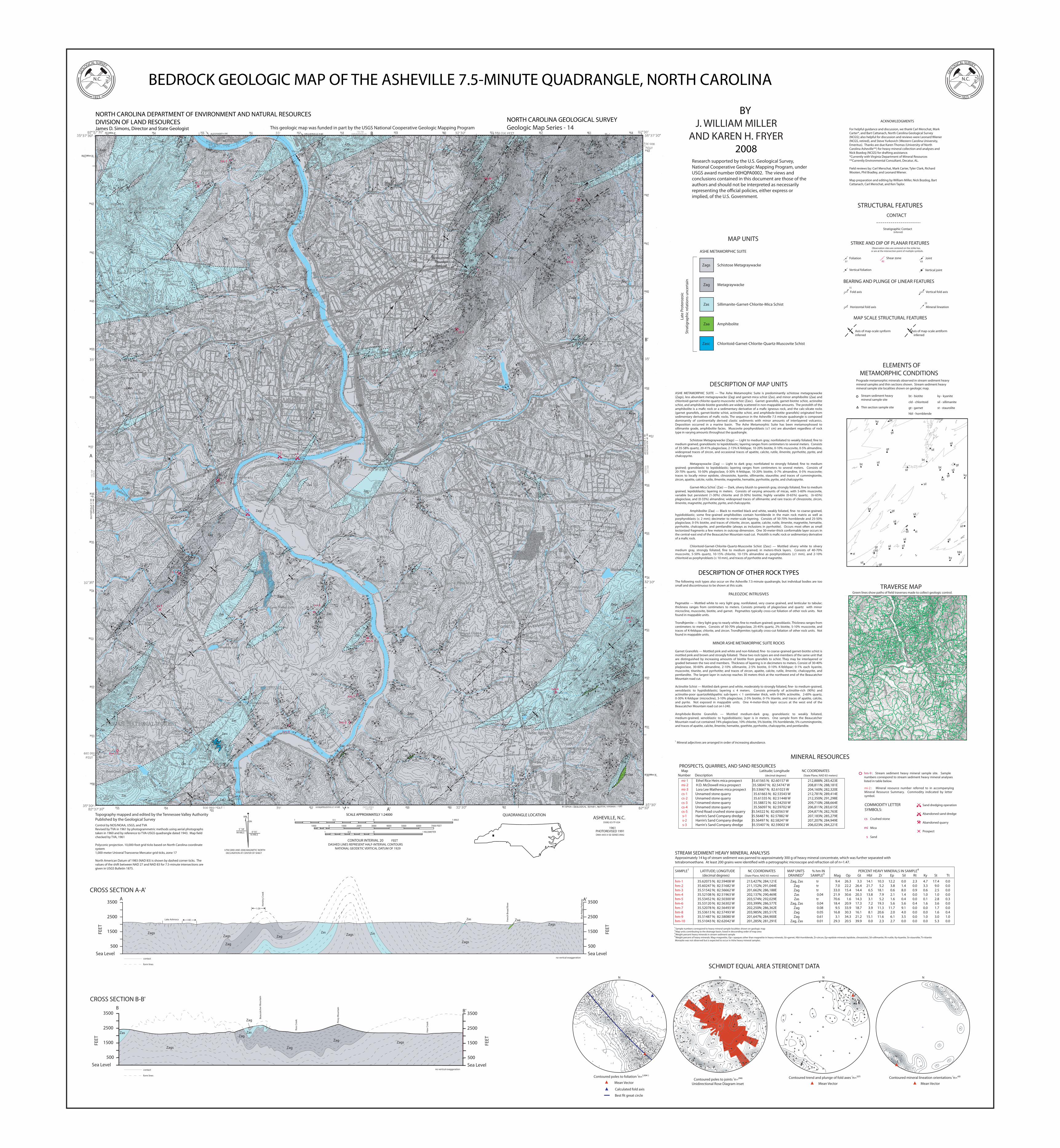
i c a l surv bedrock geologic map of the asheville 7.5
TRANSCRIPT
QUADRANGLE LOCATION 1
1 0.5 0 1 KILOMETER
1000 1000 2000 3000 4000 5000 6000 7000 FEET 0
0 0.5 1 MILE
CONTOUR INTERVAL 20 FEET DASHED LINES REPRESENT HALF-INTERVAL CONTOURS
NATIONAL GEODETIC VERTICAL DATUM OF 1929
SCALE APPROXIMATELY 1:24000 MN
GN
5 0 55'
o
o 99 MILS
16 MILS
UTM GRID AND 2008 MAGNETIC NORTH DECLINATION AT CENTER OF SHEET
58'
Topography mapped and edited by the Tennessee Valley Authority Published by the Geological Survey Control by NOS/NOAA, USGS, and TVARevised by TVA in 1961 by photogrammetric methods using aerial photographs taken in 1960 and by reference to TVA-USGS quadrangle dated 1943. Map �eld checked by TVA, 1961
Polyconic projection. 10,000-foot grid ticks based on North Carolina coordinate system1,000-meter Univeral Transverse Mercator grid ticks, zone 17
North American Datum of 1983 (NAD 83) is shown by dashed corner ticks. The values of the shift between NAD 27 and NAD 83 for 7.5-minute intersections are given in USGS Bulletin 1875.
ASHEVILLE, N.C. 35082-E5-TF-024
1961 PHOTOREVISED 1991 DMA 4455 II SE-SERIES V842
(WEAVERVILLE) 192-NE
(OTE
EN)
201-
SW
(SKYLAND) 193-NE
(EN
KA)
192-
SW
TRAVERSE MAP Green lines show paths of �eld traverses made to collect geologic control.
Zags Zags
Zags
Zags
Zags
Zags
Zags
Zags
Zags Zags
Zags
Zags
Zags
Zags
Zags
Zags
Zags
Zags
Zags
Zags
Zags
Zags
Zags
Zags
Zag
Zags
Zags
Zags
Zags
Zags
Zags
Zags
Zags
Zags
Zags
Zags
Zags
Zags
Zags
Zags
Zags
Zags
Zas
Zas
Zas
Zas
Zas
Zas
Zas
Zas Zas
Zas
Zas
Zas
Zas
Zas
Zags
Zas
Zag
Zag
Zas
Zas
Zas
Zas
Zas
Zag
Zas
Zas
Zas
Zas
Zas
Zasc
Zas
Zas
Zas
Zas Zas
Zaa
Zaa
Zaa Zaa
Zas
Zag
Zag
Zas Zas
Zag
Zag
Zag
Zag
Zas
Zas
Zag
Zags
Zags
Zas
Beaucatcher Mountain road cut
hm-1
hm-4
hm-5
hm-9
hm-3
hm-7
hm-6
hm-8
hm-10
hm-2
mi-2
mi-1
mi-3
cs-1
cs-5
s-1 s-2
s-3
cs-2
cs-3
cs-4
MINERAL RESOURCES
COMMODITY LETTER SYMBOLS:
cs Crushed stone
mi Mica
s Sand
Sand dredging operation
Abandoned sand dredge
Abandoned quarry
Prospect
hm-9 : Stream sediment heavy mineral sample site. Sample numbers correspond to stream sediment heavy mineral analyses listed in table below.
PROSPECTS, QUARRIES, AND SAND RESOURCES Map Latitude; Longitude NC COORDINATES Number Description (decimal degrees) (State Plane, NAD 83 meters)
mi-1 Ethel Rice Heirs mica prospect 35.61565 N; 82.60157 W mi-2 H.D. McDowell mica prospect 35.58047 N; 82.54747 W mi-3 Lora Lee Mathews mica prospect 35.53667 N; 82.61023 W cs-1 Unnamed stone quarry 35.61663 N; 82.53543 W cs-2 Unnamed stone quarry 35.61335 N; 82.51448 W cs-3 Unnamed stone quarry 35.58872 N; 82.54250 W cs-4 Unnamed stone quarry 35.56097 N; 82.59702 W cs-5 Pond Road crushed stone quarry 35.54322 N; 82.60563 W s-1 Harrin’s Sand Company dredge 35.56487 N; 82.57882 W s-2 Harrin’s Sand Company dredge 35.56497 N; 82.58247 W s-3 Harrin's Sand Company dredge 35.55407 N; 82.59002 W
212,888N; 283,423E 208,811N; 288,181E 204,160N; 282,320E 212,781N; 289,414E 212,350N; 291,298E 209,710N; 288,664E 206,811N; 283,615E 204,871N; 282,763E 207,183N; 285,279E 207,207N; 284,949E 206,023N; 284,221E
mi-2 : Mineral resource number referred to in accompanying Mineral Resource Summary. Commodity indicated by letter symbol.
Joint
Vertical foliation
STRUCTURAL FEATURES
BEARING AND PLUNGE OF LINEAR FEATURES
CONTACT
Fold axis
Stratigraphic Contact (inferred)
Vertical fold axis
Horizontal fold axis Mineral lineation
Observation sites are centered on the strike bar, or are at the intersection point of multiple symbols.
STRIKE AND DIP OF PLANAR FEATURES
Foliation
Vertical joint
MAP SCALE STRUCTURAL FEATURES
Axis of map-scale synform Axis of map-scale antiform inferred inferred
37
15
23
82 Shear zone
63
N
Contoured trend and plunge of fold axes (n=127)
Mean Vector
N
Contoured poles to foliation (n=1,504 )
Mean Vector
N
Contoured mineral lineation orientations (n=43)
Mean Vector
N
Contoured poles to joints (n=290)Unidirectional Rose Diagram inset
SCHMIDT EQUAL AREA STEREONET DATA
Calculated fold axis
Best �t great circle
sil
st
ky
sil
gt bt
gt
ky
bt
bt
bt
bt
gt
gt
bt sil gt
sil gt
sil
sil
gt
hbl
sil
sil
sil
sil
sil sil
st
sil
sil
ky
sil
ELEMENTS OF METAMORPHIC CONDITIONS
Prograde metamorphic minerals observed in stream sediment heavy mineral samples and thin sections shown. Stream sediment heavy mineral sample site localities shown on geologic map.
cld
bt - biotite
cld - chloritoid
gt - garnet
hbl - hornblende
ky - kyanite
sil - sillimanite
st - staurolite Thin section sample site
Stream sediment heavy mineral sample site
STREAM SEDIMENT HEAVY MINERAL ANALYSISApproximately 14 kg of stream sediment was panned to approximately 300 g of heavy mineral concentrate, which was further separated withtetrabromoethane. At least 200 grains were identi�ed with a petrographic microscope and refraction oil of n=1.47.
SAMPLE1 LATITUDE; LONGITUDE NC COORDINATES MAP UNITS % hm IN PERCENT HEAVY MINERALS IN SAMPLE4
(decimal degrees) (State Plane, NAD 83 meters) DRAINED2 SAMPLE3 Mag Op Gt Hbl Zr Ep Sil Rt Ky St Tt
hm-1 35.62073 N; 82.59408 W 213,427N; 284,121E Zag, Zas tr 9.4 26.3 3.3 14.1 10.3 12.2 0.0 2.3 4.7 17.4 0.0 hm-2 35.60247 N; 82.51682 W 211,152N; 291,044E Zag tr 7.0 22.2 26.4 21.7 5.2 3.8 1.4 0.0 3.3 9.0 0.0 hm-3 35.51542 N; 82.56662 W 201,662N; 286,188E Zag tr 33.0 15.4 14.4 6.5 18.1 0.6 8.0 0.9 0.6 2.5 0.0hm-4 35.52108 N; 82.51963 W 202,137N; 290,469E Zas 0.04 21.9 30.6 20.3 13.8 7.9 2.1 1.4 0.0 1.0 1.0 0.0hm-5 35.53452 N; 82.50300 W 203,574N; 292,029E Zas tr 70.6 1.6 14.3 3.1 5.2 1.6 0.4 0.0 0.1 2.8 0.3hm-6 35.53120 N; 82.56302 W 203,399N; 286,577E Zag, Zas 0.04 18.4 20.9 17.3 7.2 19.3 5.6 5.6 0.4 1.6 3.6 0.0hm-7 35.52078 N; 82.56493 W 202,250N; 286,362E Zag 0.08 9.5 33.9 18.7 3.9 11.3 11.7 9.1 0.0 0.0 1.7 0.0hm-8 35.53613 N; 82.57493 W 203,985N; 285,517E Zag 0.05 16.8 30.3 16.1 8.1 20.6 2.0 4.0 0.0 0.0 1.6 0.4hm-9 35.51487 N; 82.58080 W 201,647N; 284,900E Zag 0.61 3.1 34.3 21.2 15.1 11.6 6.1 3.5 0.0 1.0 3.0 1.0hm-10 35.51043 N; 82.62042 W 201,285N; 281,291E Zag, Zas 0.01 29.3 20.5 39.9 0.0 2.3 2.7 0.0 0.0 0.0 5.3 0.0
Sample numbers correspond to heavy mineral sample localities shown on geologic map Map units contributing to the drainage basin, listed in descending order of map area Weight percent heavy minerals in stream sediment sample Weight percent of heavy minerals: Mag=magnetite, Op= opaques other than magnetite in heavy minerals, Gt=garnet, Hbl=hornblende, Zr=zircon, Ep=epidote minerals (epidote, clinozoisite), Sil=sillimanite, Rt=rutile, Ky=kyanite, St=staurolite, Tt=titaniteMonazite was not observed but is expected to occur in Ashe heavy mineral samples.
1 2
3
4
ASHE METAMORPHIC SUITE
Late
Pro
tero
zoic
St
ratig
raph
ic re
latio
ns u
ncer
tain
Schistose Metagraywacke Metagraywacke Sillimanite-Garnet-Chlorite-Mica Schist Amphibolite Chloritoid-Garnet-Chlorite-Quartz-Muscovite Schist
Zags
Zag
Zas
Zaa
Zasc
MAP UNITS
A'
B
B'
A
I-26
Lake Ashnoca
Fren
ch B
road
Riv
er
Blue
Rid
ge P
arkw
ay
Hom
iny
Cree
k
Zag
CROSS SECTION A-A' A A’
1500
2500
3500
FEET
500
Sea Level
1500
2500
3500
FEET
500
Sea Level
I-40
x
Beau
catc
her M
ount
ain
Pine
y M
ount
ain
Zags
Zag
Zag
Zag
Zag
Zag
Zas
Zags
Zags
Zags
ZagsZagsZags
Zas
Zag
Ross
Cre
ek
Haw
Cre
ek
Zas
Zas Zas
Zas
B’
CROSS SECTION B-B'
1500
2500
3500
FEET
500
Sea Level
B
1500
2500
3500
FEET
500
Sea Level
Zaa
contact
form lines
contact
form lines
no vertical exaggeration
no vertical exaggeration
DESCRIPTION OF MAP UNITSASHE METAMORPHIC SUITE — The Ashe Metamorphic Suite is predominantly schistose metagraywacke (Zags), less abundant metagraywacke (Zag) and garnet-mica schist (Zas), and minor amphibolite (Zaa) and chloritoid-garnet-chlorite-quartz-muscovite schist (Zasc). Garnet granofels, garnet-biotite schist, actinolite schist, and amphibole-biotite granofels are widely scattered in non-mappable amounts. The protolith of the amphibolite is a ma�c rock or a sedimentary derivative of a ma�c igneous rock, and the calc-silcate rocks (garnet granofels, garnet-biotite schist, actinolite schist, and amphibole-biotite granofels) originated from sedimentary derivatives of ma�c rocks. The sequence in the Asheville 7.5 minute quadrangle is composed dominantly of continentally derived clastic sediments with minor amounts of interlayered volcanics. Deposition occurred in a marine basin. The Ashe Metamorphic Suite has been metamorphosed to sillimanite grade, amphibolite facies. Muscovite porphyroblasts (≤1 cm) are abundant regardless of rock type in varying amounts throughout the quadrangle.
Schistose Metagraywacke (Zags) — Light to medium gray; nonfoliated to weakly foliated; �ne to medium grained; granoblastic to lepidoblastic; layering ranges from centimeters to several meters. Consists of 35-58% quartz, 20-41% plagioclase, 2-15% K-feldspar, 10-20% biotite, 0-10% muscovite, 0-5% almandine, widespread traces of zircon, and occasional traces of apatite, calcite, rutile, ilmenite, pyrrhotite, pyrite, and chalcopyrite.
Metagraywacke (Zag) — Light to dark gray; nonfoliated to strongly foliated; �ne to medium grained; granoblastic to lepidoblastic; layering ranges from centimeters to several meters. Consists of 20-70% quartz, 10-50% plagioclase, 0-30% K-feldspar, 10-20% biotite, 0-7% almandine, 0-5% muscovite; traces to locally minor epidote, clinozoisite, kyanite, sillimanite, staurolite; and traces of cummingtonite, zircon, apatite, calcite, rutile, ilmenite, magnetite, hematite, pyrrhotite, pyrite, and chalcopyrite.
Garnet-Mica Schist1 (Zas) — Dark, silvery bluish to greenish gray, strongly foliated, �ne to medium grained, lepidoblastic; layering in meters. Consists of varying amounts of micas, with 5-60% muscovite, variable but persistent (1-30%) chlorite and (0-30%) biotite; highly variable (0-65%) quartz, (tr-65%) plagioclase, and (0-33%) almandine; widespread traces of sillimanite; and rare traces of clinozoisite, zircon, ilmenite, magnetite, pyrrhotite, pyrite, and chalcopyrite.
Amphibolite (Zaa) — Black to mottled black and white, weakly foliated, �ne- to coarse-grained, hypidioblastic; some �ne-grained amphibolites contain hornblende in the main rock matrix as well as porphyroblasts (≤ 2 mm); decimeter to meter-scale layering. Consists of 50-70% hornblende and 25-50% plagioclase, 0-5% biotite, and traces of chlorite, zircon, apatite, calcite, rutile, ilmenite, magnetite, hematite, pyrrhotite, chalcopyrite, and pentlandite (always as inclusions in pyrrhotite). Occurs most often as small tectonized fragments a few meters in outcrop dimension. One 30-meter-thick conformable layer occurs in the central-east end of the Beaucatcher Mountain road cut. Protolith is ma�c rock or sedimentary derivative of a ma�c rock.
Chloritoid-Garnet-Chlorite-Quartz-Muscovite Schist (Zasc) — Mottled silvery white to silvery medium gray, strongly foliated, �ne to medium grained; in meters-thick layers. Consists of 40-70% muscovite, 5-50% quartz, 10-15% chlorite, 10-15% almandine as porphyroblasts (≤1 mm), and 2-10% chloritoid as porphyroblasts (≤ 10 mm), and traces of pyrrhotite and magnetite.
DESCRIPTION OF OTHER ROCK TYPESThe following rock types also occur on the Asheville 7.5-minute quadrangle, but individual bodies are too small and discontinuous to be shown at this scale.
PALEOZOIC INTRUSIVES
Pegmatite — Mottled white to very light gray, nonfoliated, very coarse grained, and lenticular to tabular; thickness ranges from centimeters to meters. Consists primarily of plagioclase and quartz with minor microcline, muscovite, biotite, and garnet. Pegmatites typically cross-cut foliation of other rock units. Not found in mappable units.
Trondhjemite — Very light gray to nearly white; �ne to medium grained; granoblastic. Thickness ranges from centimeters to meters. Consists of 50-70% plagioclase, 25-45% quartz, 2% biotite, 5-10% muscovite, and traces of K-feldspar, chlorite, and zircon. Trondhjemites typically cross-cut foliation of other rock units. Not found in mappable units.
MINOR ASHE METAMORPHIC SUITE ROCKS
Garnet Granofels — Mottled pink and white and non-foliated; �ne- to coarse-grained garnet-biotite schist is mottled pink and brown and strongly foliated. These two rock types are end-members of the same unit that are distinguished by increasing amounts of biotite from granofels to schist. They may be interlayered or graded between the two end members. Thickness of layering is in decimeters to meters. Consist of 30-40% plagioclase, 30-60% almandine, 2-10% sillimanite, 2-5% biotite, 0-10% K-feldspar; 0-1% each kyanite, muscovite, titanite, and pyrrhotite; and traces of zircon, apatite, calcite, rutile, ilmenite, chalcopyrite, and pentlandite. The largest layer in outcrop reaches 30 meters thick at the northwest end of the Beaucatcher Mountain road cut.
Actinolite Schist — Mottled dark green and white, moderately to strongly foliated, �ne- to medium-grained, xenoblastic to hypidioblastic; layering ≤ 4 meters. Consists primarily of actinolite-rich (90%) and actinolite-poor quartzofeldspathic sub-layers < 1 centimeter thick, with 0-90% actinolite, 2-60% quartz, 0-30% K-feldspar (microcline), 3-10% plagioclase, 2-5% biotite, 0-1% titanite, and traces of apatite, calcite, and pyrite. Not exposed in mappable units. One 4-meter-thick layer occurs at the west end of the Beaucatcher Mountain road cut on I-240.
Amphibole-Biotite Granofels — Mottled medium-dark gray, granoblastic to weakly foliated, medium-grained, xenoblastic to hypidioblastic; layer is in meters. One sample from the Beaucatcher Mountain road cut contained 74% plagioclase, 10% chlorite, 5% biotite, 5% hornblende, 5% cummingtonite, and traces of apatite, calcite, ilmenite, hematite, goethite, pyrrhotite, chalcopyrite, and pentlandite.
1 Mineral adjectives are arranged in order of increasing abundance.
ACKNOWLEDGMENTS
For helpful guidance and discussion, we thank Carl Merschat, Mark Carter*, and Bart Cattanach, North Carolina Geological Survey (NCGS); also helpful for discussion and reviews were Leonard Wiener (NCGS, retired), and Steve Yurkovich (Western Carolina University, Emeritus). Thanks are due Karen Thomas (University of North Carolina Asheville**) for heavy mineral collection and analyses and Nick Bozdog (NCGS) for drafting assistance. *Currently with Virginia Department of Mineral Resources **Currently Environmental Consultant, Decatur, AL. Field reviews by: Carl Merschat, Mark Carter, Tyler Clark, Richard Wooten, Phil Bradley, and Leonard Wiener. Map preparation and editing by William Miller, Nick Bozdog, Bart Cattanach, Carl Merschat, and Ken Taylor.
BEDROCK GEOLOGIC MAP OF THE ASHEVILLE 7.5-MINUTE QUADRANGLE, NORTH CAROLINA
NORTH CAROLINA DEPARTMENT OF ENVIRONMENT AND NATURAL RESOURCES DIVISION OF LAND RESOURCES James D. Simons, Director and State Geologist
NORTH CAROLINA GEOLOGICAL SURVEY
BY J. WILLIAM MILLER
AND KAREN H. FRYER
2008
This geologic map was funded in part by the USGS National Cooperative Geologic Mapping Program Geologic Map Series - 14
N.C.
1823
GEOLO
GICAL SURVEY
Research supported by the U.S. Geological Survey, National Cooperative Geologic Mapping Program, under USGS award number 00HQPA0002. The views and conclusions contained in this document are those of the authors and should not be interpreted as necessarily representing the o�cial policies, either express or implied, of the U.S. Government.
N.C.
1823
GEOLO
GICAL SURVEY
24
58 30 35
53 43
72 85
25 88 76
73
13
83
20
52
31
33
49
40
63
56
81
47 20
83
36 49
75 78 22
74
18
49
08 73
78 25
60
23
39
84
17 76
23 85
23
9
24
33 81
41 88
60 85 19
24
74 75
75
15
75
78 30
58
26
20
61
77 18
67
86
20 67
8 62
65 57 37 30
9
25
25
43 13 72
22 82
20
82
88 88
24
14 85
84
37
82 25
87
84
66 66
58
77
71
57 88
68 75 36
83 34
55 83
30
68
34
04
27
72 38
37
53
69
78
77
42
64
82
58
57 32
60
74
68
54
78 27
36 62
62
8
49
61
60
43
73
58 65
66 34
39 53
8
55 39
44 36
86
47 66
60 48
81 69
28
63
19
63 34
83
25 8
7 71
8 32
28
26
14 24
82
20
11
83
43
52
81 85 41
33
9
54 69
47 34 67 35
65 44
88 23
58 6
55 28
78
59
28
52
51 35
5
86
73
28
28
22 31
20
89
17
80
48 14 71
20
61 66
52
42
78
59
73
54
52
34 83
37
42
42
30
54
52 28
88 75
70 75
83 78
65
4
35
85
73
70
65 68 39
12 85 51
15
77 25
64
9 72 48
88
59
83 37
32 46 88
43
85
54
58
28 88 71
35
68
77
37
75 81 66 60 82
67 74
54 71
63
78 64
54 63
67
80 81
36
78
71
28 46
7
73 68
34
20
66
22 67
42
42
86 78
47
50 68
20
27
24 52 59
25 50
41
28
58 54
24 70
75 88
75 75
55
74 83
83 76
76
13
63
64
13
86 52
44 60
84
72
75
51 28
84
40
12
05
78 77
81
57
62 48
64 68
76
59
79
79 47
68
74
80
74
84
62
89
57
71 86
53
76
11
84
83 23
83 83
72
79
77
77
61
4
53
7
58 80 69
74
81
66
68 82
86
51
79
76
60
75 71 34
46 53
76 41
31
60 72
78 87
33
79 18
49 51
64
87 33
73
51 71 78
54
8
80
63
79
46
80
67 65 82
70
72
75 82
57 65
70
77 59
58 42 72
86
72
75 72
57 61
22 29
75
76 52
11
72
66
08
10
68
71
68 64
58
58
58 85
39
66 88
72
88
19
55
04
82
72
41
63
53
51 42 51 52
54
54
57 67
84
65 44
52 48 45 83
9
9 79
87 66
83 47
59 72
85
49
76
73 87 83
79
49 36 69
77
37
74 83
78
80
34
18
18
19
63
81
75
87
58 89
74
81 81 42
62 68 57
73
58
15
38 8
32
32
38
24 23
86
65
62
47 46
66 73
27 86
34 52
16
34
56
53
59
65
63 15 60
18 83
84
86 48
77 45
79
86
5
48-82
74 62
59 52
86 35
87 46
38 48
32
78 73
75 74
38
75
36 10
86
61 62
46
82
88
60
67
77
85 63
78
43
79 44
53
70
52
78
85 81
66
24 56
38
35 33
25 38
55
79
53 87
70
72 84 86
72
22
57
37
56 72
84 84
82
78
76 82
75
61
70 66
73
44
41
78
76 86 83 71
66 77
5
82
77 82
86
86
66 24
84
43 78
64 81
34 36
57
83
80
54
52 81
75 56
68
59 89
11
71
68 73
59
35
73
62
73
62
58 79
54
15 42
27 16
53 46
54
53
42
51
29
79 66
53
48
83
47 86
22
36
67
87
36
77
42
30 41
88 55
55
58 37
48 75
75
46
38 36
55
81
72 49 82 77
65 85
77
77
83
83
26 86 64
42 67
79 68
69 84
47 72
25
82
88 86
43
69
52
30
52
60
76 24
10
57
18
32
39
11
20 33
88
26
76
55
72
19
60
88
75
85
82
85
88
57
65
63 87
83
87
42 60
58
85 85
86 83
75
50
57 64
64
52
55
43
52
23
63
84 51
76 66
72
51
35
56
68
40
79
57
88
58
75
70
49
87
69
27 24 53 47
75
85
18
80
85
76
85 81
37
49
74
59
68
72
76
79 43 72
56
81 81
73
86
55
67
71 81
19
55
35
51
40
55
74
80
35
79 87
82
58
57 77
64
10 36
41
64
60
52 48
81 73
88
80
42
67
66
85 71
22
63
73 72
84
54
71
82
73
69
86
18 84
50
59
28
84
63
68
63 49
72
55
60
70
50
65
30
40
85
72
53
82 63 79
84
55
80
68
85
84
68
69
88
60
70
41
42
30
35 35 37
29
19
64
12
68
74 82
89
85
54
86
86
70
15
66
48
81
71
84
83 81
75
84
66
65
27
52
74
68
52
68
75
17
68
64
82
69 86
76 88
71
87
63
56
62
72
63 56
58 86
21
70 66
83
75 24 87
88 81
52
89
17
87
66
56 50
24
34
72
27
7
86
16 41
86 72
63
45
67
50
79 74
65
30 75
27
44
75
60
32
78
18
3 20
8
82
85
21
73
41
29
26 30
69
69
35
56
15 14
39
17 25
42
25
54 30
31
21
05 46
63
79
75
44
22 82
68 19
73
33 1
23
17
67
80
34
67
53
2
25
32 54
78
18
29
24 32
43
79
41
43
27
86
54
22 35
41
70
31
30
61
32
46
30
33
29
54
21
43 42
84 62
29
19
43
32
15
20 55
56 18
40 51
30
13
21
14
3
13
18
28
11
21
70 30
36
33 25
32
69
20
72
49
25
16
74
04
9
03
18
14 1
23
14
18 10
17
55
72
84
88
63
78
30
67
20
68
30
42
35
40
46
24
27
18
18
74
82
1
34
14
51
76
61
8 46
30
56
62
30
3
17
7
75
41
14
72
71
7
70
26
18
4 14
5
2
7
5
19
16
6
78
69 89 82
87 86
72
84
29 49 44
61
49 58 62 88
59 72
74
54 85
64
36
77
59
64
51
43
74 53
20 13
70
73 70
83
19 62
70
54
42
43
38
33
10
88
58 5
61
8
5 21
24 27
42
44
51
80
33
62
43
89
68
67
44
66
66
58
42
79
28
78
56 64
26
82
84
77
50
25
32
17 30
45 70
59
29
63
62 37
63
82
65
62
64
33
35
63
80
39
3 10
60 84
85
12
8
68
76
71
86
66
48
56
88
25 73
64
43 46
37
35 15 85
18
20 20
42
53
54
44
40
12
85 62
26 88 73 29
88
87 88 86
82
49 78
38
28
31
45 22
31
41 52
22
15
40 24
34 43
23
49
45
27 11
39
8 12
29
26
81 21
26
19
20 68
46
18 30 30 13
28 16 14
88
82
78
7
83