hydrological risk characteristics of the ozana river valley
TRANSCRIPT
PRESENT ENVIRONMENT AND SUSTAINABLE DEVELOPMENT, VOL. 6, no. 2, 2012
HYDROLOGICAL RISK CHARACTERISTICS OF THE OZANA RIVER VALLEY
Marina Iosub1, Dan Lesenciuc2
Keywords: hydrological risk, river valley, floods, run-off, drying up Abstract. The occurrence of hydrological risk phenomena is conditioned by a series of factors, related to climatic, geologic, geomorphologic, pedologic, vegetal aspects etc., which are specific to the drainage basin of the Ozana river. The hydrological risk that has a major impact upon the human settlements in the area, is conditioned by the presence of floods which frequently occur in the rivers flood plain. In this present study, we have emphasised the floods that took place between 2005 and 2008, including the maximum maximorum run-off rate of 456 m³/s, recorded at the Dumbrava hydrometric station, in 2005. By utilising the data gathered from the hydrometric stations, located on the Ozana river valley, we have analysed the propagation of the flood waves generated in the three sectors of the drainage basin: the upper, middle and lower sector. After the analysis, we have observed the fact that the area that was most affected by the floods is the upstream river sector, where numerous households and roads have been flooded. Another aspect of the hydrological risk is related to the minimum run-off of the Ozana river, which is influenced by climatic conditions and alluvial deposits from the riverbed. Therefore, during draughts, taking into consideration the presence of very thick Quaternary deposits, the river runs dry on its lower course, for a variable period of time, which can be from a few days, to six months, every year. This phenomenon directly affects the local population, especially through the diminished water reserve in the area.
1. Physical Geographical Features That Determine The Occurrence Of The Hydrological Risk On The Ozana River Valley
The hydrographic basin of the Ozana river is situated in the north-east side of the Oriental Carpathian Mountains, being located between the 47º08’19” and 47º18’15” paralells north, and the 25º55’35” and 26º33’45” meridians eastern longitude (Fig. 1). The river basin has a surface of 419 km², with a perimeter that is 135 km long, occupying about 0,2% of the country's total surface area, and 1 Mast., Alexandru Ioan Cuza University, Iasi, Romania 2 Lect. PhD., Alexandru Ioan Cuza University, Iasi, Romania

Marina Iosub, Dan Lesenciuc
208
approximately 7% of Neamţ county. The basin is elongated on a west - east direction, being 54 kilometers long, and the maximum width is 17 kilometers.
Fig. 1 - The geographic location of the Ozana river drainage basin
The landscape associated to the drainage basin of the river is structured in steps that lower from the west (Bivolul Peak, 1530 m), to the east (the confluence with the Moldova river, 270 m). The upper river sector and a large parte of the middle sector belong to the Stânişoarei Mountains, which are part of the flysch area, with a representative litology, containing sandstone, marlstone, clay etc (Ichim I. 1979). The middle and lower sector of the drainage area overlap with the northern part of the Ozana - Topoliţa depression and Pleşu peak, from the Moldavian subcarpathian area, which sits on a substrate of sedimentary rocks (clay and grey marlstones, inferior menilites, brown, bituminous marlstones and disodilic schist) (Davidescu G., 2000). And in the lower sector of the river basin, near to the confluence with the Moldova river, the most representative is the landscape of the Moldavian tableland, with the Boiştea hill (an exhumed, Sarmatian delta), with a lithologic substrate made out of gravel deposits, sand and clayey loam seams. The alluvial deposits found along the Ozana valley date back from the Pleistocene and Holocene periods and belong to the terraces and flood plains (Fig no. 2).

Hydrological risk characteristics of the Ozana river valley
209
Fig. 2 - Map of the main geological features and structures in the drainage basin of the Ozana river
The orientation of the valley on a W - E direction and the gradual loss in
altitude on the same direction determine a strongly - related contact with the climatic aspects in the same direction and intensity. As far as the rainfall distribution is concerned, we can observe a repartition according to the specific altitudes. Significant, zonal, differences can be seen between the Stânişoarei Mountains and the subcarpathian and plateau area, the mean rainfall values dropping on a regular basis from the west, towards the east. Pluviometric differences determine the much faster occurrence of the floods in the mountain region, where, due to the landscape configuration, more damages are inflicted. The months that register significant rainfalls are: may, june, july and even august (with numerous floods in 2005, 2008 and 2010). Because of the climatic influences that have a eastern origin, rainfall can be torrential, and can sometimes reach more than 60 mm in 24 hours (in Târgu Neamţ city, 67,6 mm fell în 24 hours, in july, 1965) (Davidescu G., 1968). The average rainfall in the summer months (may, june, july and august) is about 409 mm, and the lowest rainfall values are recorded in the winter months (january and february), with a multiannual mean value of 57 mm. The annual average value for rainfall in the drainage basin of the Ozana river

Marina Iosub, Dan Lesenciuc
210
decreases from the west (817,73 mm at Pluton), to the east (640,13mm at Dumbrava),(Fig no. 3).
Fig 3 - The average, multiannual rainfall in the Ozana drainage basin (1970-2009)
Fig 4 - Map of the main types of vegetation in the drainage basin of the Ozana river
The forests form the vegetal cover, which has the largest spread in the mountain area, including on the subcarpathian peaks, occupying 64% of the total drainage basin area (Fig. no. 4). On the Ozana river valley, many areas are heavily
Hydrological risk characteristics of the Ozana river valley
211
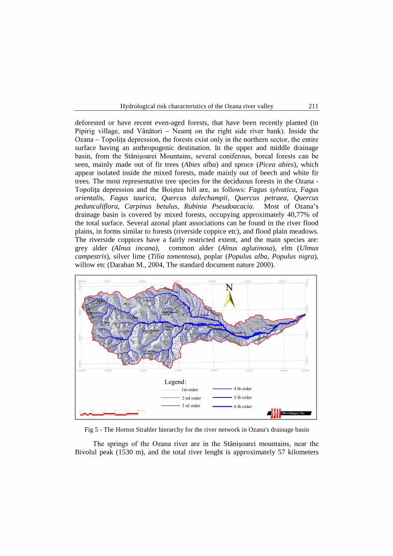
deforested or have recent even-aged forests, that have been recently planted (in Pipirig village, and Vânători – Neamţ on the right side river bank). Inside the Ozana – Topoliţa depression, the forests exist only in the northern sector, the entire surface having an anthropogenic destination. In the upper and middle drainage basin, from the Stânişoarei Mountains, several coniferous, boreal forests can be seen, mainly made out of fir trees (Abies alba) and spruce (Picea abies), which appear isolated inside the mixed forests, made mainly out of beech and white fir trees. The most representative tree species for the deciduous forests in the Ozana - Topoliţa depression and the Boiştea hill are, as follows: Fagus sylvatica, Fagus orientalis, Fagus taurica, Quercus dalechampii, Quercus petraea, Quercus pedunculiflora, Carpinus betulus, Rubinia Pseudoacacia. Most of Ozana’s drainage basin is covered by mixed forests, occupying approximately 40,77% of the total surface. Several azonal plant associations can be found in the river flood plains, in forms similar to forests (riverside coppice etc), and flood plain meadows. The riverside coppices have a fairly restricted extent, and the main species are: grey alder (Alnus incana), common alder (Alnus aglutinosa), elm (Ulmus campestris), silver lime (Tilia tomentosa), poplar (Populus alba, Populus nigra), willow etc (Daraban M., 2004, The standard document nature 2000).
Fig 5 - The Horton Strahler hierarchy for the river network in Ozana's drainage basin
The springs of the Ozana river are in the Stânişoarei mountains, near the Bivolul peak (1530 m), and the total river lenght is approximately 57 kilometers

Marina Iosub, Dan Lesenciuc
212
long. Ozana’s river course runs through the Pipirig, intramontane depression and the Ozana – Topoliţa subcarpathian depression, which are two depressions well populated, where the households are positioned mostly in the river’s flood plains. The right hand side main tributaries of the river are Pluton, Domesnic and Secu, and on the left hand side, the main one is Nemţişorul (also being the most important tributary of Ozana). Ozana’s drainage basin has a total surface of 419.35 km² and a total lenght of the drainage network of 1567,13 km, with an average density of 3,74 km/km². The hydrological network has been hierarchised conforming to the Strahler model, which revealed six river orders (Fig no. 5).
The average, multiannual run-off capacity has been calculated to 0,39 m³/s at Pluton, 2,22 m³/s at Leghin and 4,44 m³/s at Dumbrava. The maximum run-off capacity, with a 1% probability level has been recorded at 456 m³/s, and the minimum reaches 0 m³/s, both values being recorded at the Dumbrava hydrometric station.
The physical geographical features favour the occurrence and manifestation of certain hydrological risk phenomena, of which the most important are the floods and the drainage of the river.
2. Methodes and techniques The statistical data has been obtained from the Basinal Administration of
the Siret and Bacau rivers (water flow, levels and the hydrographs of the floods), and also from ISUJ Neamt, Petrodava and Piatra Neamt. The analysed data has been collected from three hydrometrical stations: Pluton, Leghin and Dumbrava.
The thematic maps were obtained by extracting certain elements from the topographic map, at a 1:25.000 scale. For this substrate study, geological maps have been utilised, at a 1:200.000 scale (papers 12 and 13, 1968 edition). The Corine Land Cover 2000 layer was used, in the making of the land use map (source: www.geospatial.org). These sets of data were selected, in order to generate a spatial perspective of the study area.
We have made the Horton-Strahler river hierarchy map in order to see the river orders that are mostly responsible for generating the biggest floods. Along the entire Ozana river basin (upstream of its outlet into the Moldova river), 6 river orders have been identified, at the study scale, of 1:25.000
The Numerical Terrain Model was processed, for the proper delimitation of the area exposed to the flood risk, therefore identifying the major flood risk zones.
Field observations have been gathered, especially for the exposed areas, during the month of august 2010, on the Ozana river floodplain, to assess the damages caused by the recent flood.
The software used in the making of the study were TNTMips (version 6.9), Gimp and Open Office Suite (for database analysing and text formatting).

Hydrological risk characteristics of the Ozana river valley
213
3. Floods – a hydrological risk phenomena The distribution of floods during one year varies, most of them have been
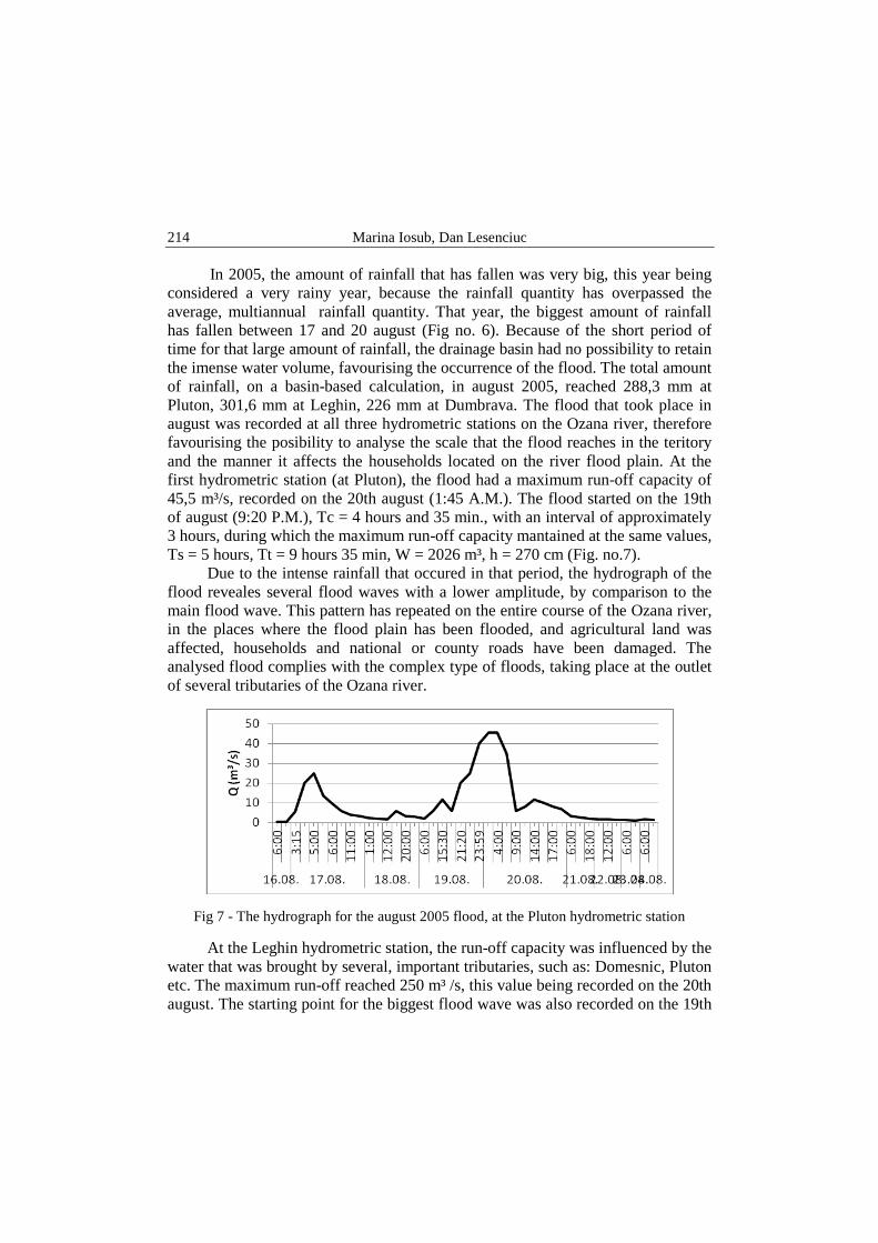
recorded during the summer period, with a 65% occurrence, and, by comparison, spring has a 29% rate of the total number of floods, during one year. The floods that have a catastrophic effect, which take place during autumn, have a low frequency, with a maximum run-off capacity that peaks 318 m³/s (06.09.1989 Dumbrava), and during the winter season, no floods have been recoreded. The months during which the most numerous flood phenomena occur are: august (29%), june (29%) and april (18%). Therefore, this monthly distribution indicates the fact that the floods are generated almost completely by the water from rainfall (Davidescu G. 2000). In order to emphasize the flood risk phenomenon, we have analysed the flood that took place in august, 2005, during which the maximum run-off capacity of 456 m³/s was reached on the 20th of august (6 A.M.), at the Dumbrava hydrometric station. The main, specific parameters of a flood are represented by: the main run-off capacity (Qb), the duration of the water level rise (Tc); the duration of the water level decrease (Ts); total duration (Tt); maximum run-off capacity (Qmax); the total water volume that has been drained (W) and the height of the water level, that has been drained during the flood (h) (Romanescu Ghe., 2009). It is characterised by an oscilatory behaviour, with a first flood wave which was small (reaching a Qmax = 41,5 m³/s, then a sudden decrease to 9,9 m³/s). This was just an announcement of the bigger flood, which was about to come in a few hours, being based on heavy rainfall on the entire drainage basin and favourising synoptic conditions. At the same station, other values of the specific parameters are: Qb = 7 m³/s, Tc = 12 hours ( for the main flood wave), Ts = 48 ore, Qmax = 456 m³/s, Tt = 60 hours, W = 9435 m³, h = 229 cm.
Fig 6 - The quantity of rainfall for august 2005 at the Leghin hydrometric station
Marina Iosub, Dan Lesenciuc
214
In 2005, the amount of rainfall that has fallen was very big, this year being considered a very rainy year, because the rainfall quantity has overpassed the average, multiannual rainfall quantity. That year, the biggest amount of rainfall has fallen between 17 and 20 august (Fig no. 6). Because of the short period of time for that large amount of rainfall, the drainage basin had no possibility to retain the imense water volume, favourising the occurrence of the flood. The total amount of rainfall, on a basin-based calculation, in august 2005, reached 288,3 mm at Pluton, 301,6 mm at Leghin, 226 mm at Dumbrava. The flood that took place in august was recorded at all three hydrometric stations on the Ozana river, therefore favourising the posibility to analyse the scale that the flood reaches in the teritory and the manner it affects the households located on the river flood plain. At the first hydrometric station (at Pluton), the flood had a maximum run-off capacity of 45,5 m³/s, recorded on the 20th august (1:45 A.M.). The flood started on the 19th of august (9:20 P.M.), Tc = 4 hours and 35 min., with an interval of approximately 3 hours, during which the maximum run-off capacity mantained at the same values, Ts = 5 hours, Tt = 9 hours 35 min, W = 2026 m³, h = 270 cm (Fig. no.7).
Due to the intense rainfall that occured in that period, the hydrograph of the flood reveales several flood waves with a lower amplitude, by comparison to the main flood wave. This pattern has repeated on the entire course of the Ozana river, in the places where the flood plain has been flooded, and agricultural land was affected, households and national or county roads have been damaged. The analysed flood complies with the complex type of floods, taking place at the outlet of several tributaries of the Ozana river.
Fig 7 - The hydrograph for the august 2005 flood, at the Pluton hydrometric station
At the Leghin hydrometric station, the run-off capacity was influenced by the water that was brought by several, important tributaries, such as: Domesnic, Pluton etc. The maximum run-off reached 250 m³ /s, this value being recorded on the 20th august. The starting point for the biggest flood wave was also recorded on the 19th

Hydrological risk characteristics of the Ozana river valley
215
of august (11:00 A.M.) and the lowering of the run-off capacity took place on the 22nd august (6:00 P.M.) (Fig no. 8). The flood had Tc = 20 hours, Ts = 38 hours, Tt = 58 hours, W = 108709 m³, h = 220 cm. Like the station at Pluton, this flood wave was succeded by another wave which had a much lower intensity, but had already damaged the defense capacity against floods.
Fig no 8. The hydrograph for the august 2005 flood, at the Leghin hydrometric station
At the Dumbrava hydrometric station, the rising of the run-off capacity began on the 19th of august (6:00 P.M.), reaching a maximum value of 456 m³/s on the 20th of august (6:00 A.M.), with the maintaining of a run-off capacity of over 400 m³/s, for two hours (Fig no. 9). The occurrence time of this flood wave was of 56 hours, of which Tc = 12 hours, Ts = 42 hours, W = 145 266 m³.
Fig. 8 - The hydrograph for the august 2005 flood, at the Dumbrava hydrometric stations

Marina Iosub, Dan Lesenciuc
216
By corellating the recorded data at the three hydrometric stations, we have obtained a graphic representation, that emphasises the time/space distribution of the analysed flood. The flood propagates progressively through space, at intervals of tens of minutes. The maximum run-off capacity has been recorded at Pluton, at 1:45 A.M., at Leghin (20 km downstream) the maximum run-off capacity was recorded at 2 A.M. and at Dumbrava, the maximum was recorded at 6, in the morning (Fig no. 10). The floods that occured during this period, on the Ozana river, affected several urban and rural settlements, such as Timişeşti (Dumbrava, Plăieşu), Târgu Neamţ (Blebea village and Humuleşti – overflow, gully erosion and dam rupture in the Cetatea Neamţului area), Vânători-Neamţ (Vânători, Lunca - overflow) and Pipirig (Pipirig, Leghin, Piţiligeni, Boboieşti, Stînca, through gully erosion, streams and overflow), the DN 15b national road , at the Stînca sector, Pipirig village was seriously damaged, because of the erosion of the lef river bank, on a 200 meter section. In the Pipirig village, 4 DN bridges have been damaged, 20 national interest bridges and 14 local interest wooden bridges, 0,5 km of village streets, 20 households (and another 103 in danger of flooding), 4 ha of pastures and arable land, being flooded. For the Vânători village, the water has risen over the flood water mark, leading to the flooding of 25 households, 100 m of national road, 1 national interest bridge, 2 km of local importance road in the Lunca village, 10 ha of pastures and 5 ha of arable land. At Târgu Neamţ, the protection dam on the right bank was damaged, and several households were flooded. Around the Humuleşti village area, the left river bank, which had no protection from dams, was eroded, and the river changed its course towards the left side by 4 meters, reaching the company buildings placed on its bank. Around Blebea village, the overflow of the water affected a few h ouseholds and 20 ha of farm land and the electric grid was damaged, due to the collapsing of a few electric posts. (information from "Report regarding the effects of floods and dangerous, meteorological phenomena, in 2005" and from the data offered by the county committee for emergency situations).
After 2005, other floods took place on the Ozana river valley in 2008, during which several floods occured, starting from april, and continued until june and july. These floods have induced much damage in the villages situated on the river valley. The most affected one was Pipirig, with 11 houses and 32 households, 40 fountains, 5 ha of farmland being flooded, the DN 15B being blocked by sediments for several hours, 1 km of local road has been destroyed and also 10, local importance bridges, collapsed. Another settlement upon which the flood had a negative impact was the city of Târgu Neamţ, where the Vânătorului street was blocked with sediments for over 100 meters and in the Blebea village (neighbourhood, part of Tg. Neamţ), a backyard was flooded and 5 basements.

Hydrological risk characteristics of the Ozana river valley
217
Fig. 9 - The hydrograph for the august 2005 flood, at the Pluton, Leghin and Dumbrava hydrometric stations
Tab. 1 - Objectives that are inside the flood risk area, on the Ozana river valley, data from
"Report regarding the effects of floods and dangerous, meteorological phenomena, in 2005"
Town Village Zone de risc
Pipirig
Pipirig 20 households ; 1 Microrafinery; 0,2 km (D.C) ; 4 bridges (D.C) ; 10 crossing decks ; 1 ha farm land ; 2 ha grassland
Leghin 25 households; 1 sawmill; 2 km DN; 1 bridge; 8 crossing decks; 1,2 ha farm land; 2 ha pasture; 1 ha grassland
Piţiligeni 7 households; 1 bridge DN; 0,10 ha farm land; 1 ha pasture; 0,5 ha grassland
Boboieşti 35 households; 10 km DC; 0,5 km local roads; 5 bridges DC; 7 wooden bridges; 4 crossing decks; 0,5 ha farm land; 2 ha grassland
Stinca 36 households; 3 km DN; 2 bridges DN; 7 wooden bridge; 10 crossing decks; 1,5 ha farm land ; 1 ha pasture ; 2 ha grassland
Vânători - Neamţ
Vânători - Neamţ
10 households; 0,1 km DN 15; 1 pod DN; 1 wooden bridge; 10 ha farm land; 50 ha pasture; 3 objectives : grinding mill, rubber factory, wood factory
Lunca 30 households; 2 km local road; 2 ha farm land; 22 ha pasture Oraşul Târgu Neamţ
15 households; 4 stores + 1 slaughter house, 30 ha farm land
Timişeşti Timişeşti 5 households
Dumbrava 12 households; 26 ha farm land
In 2010, several floods occured on the Ozana river valley, with run-off capacities that have reached the attention levels. The flood that took place on the
Marina Iosub, Dan Lesenciuc
218
21st of june, formed after heavy rainfall and inflicted heavy damage in the area of the Pipirig village (8 houses have been floded and several households suffered in the Stînca village). Between Leghin and Stînca villages, the national road DN 15B was covered with alluvium, because of the slope drainage, over a distance of 150 meters. During the same flood, several local importance roads have suffered damage, 4 wooden bridges collapsed and 4 ha of farmland have been flooded. (Table no.1).
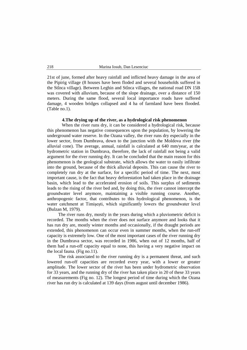
4.The drying up of the river, as a hydrological risk phenomenon When the river runs dry, it can be considered a hydrological risk, because
this phenomenon has negative consequences upon the population, by lowering the underground water reserve. In the Ozana valley, the river runs dry especially in the lower sector, from Dumbrava, down to the junction with the Moldova river (the alluvial cone). The average, annual, rainfall is calculated at 640 mm/year, at the hydrometric station in Dumbrava, therefore, the lack of rainfall not being a valid argument for the river running dry. It can be concluded that the main reason for this phenomenon is the geological substrate, which allows the water to easily infiltrate into the ground, because of the thick alluvial deposits. This can cause the river to completely run dry at the surface, for a specific period of time. The next, most important cause, is the fact that heavy deforestation had taken place in the drainage basin, which lead to the accelerated erosion of soils. This surplus of sediments leads to the rising of the river bed and, by doing this, the river cannot intercept the groundwater level anymore, maintaining a visible running course. Another, anthropogenic factor, that contributes to this hydrological phenomenon, is the water catchment at Timişeşti, which significantly lowers the groundwater level (Bulzan M, 1979).
The river runs dry, mostly in the years during which a pluviometric deficit is recorded. The months when the river does not surface anymore and looks that it has run dry are, mostly winter months and occasionally, if the draught periods are extended, this phenomenon can occur even in summer months, when the run-off capacity is extremely low. One of the most important cases of the river running dry in the Dumbrava sector, was recorded in 1986, when out of 12 months, half of them had a run-off capacity equal to none, this having a very negative impact on the local fauna. (Fig no.11).
The risk associated to the river running dry is a permanent threat, and such lowered run-off capacities are recorded every year, with a lower or greater amplitude. The lower sector of the river has been under hydrometric observation for 33 years, and the running dry of the river has taken place in 20 of these 33 years of measurements (Fig no. 12). The longest period of time during which the Ozana river has run dry is calculated at 139 days (from august until december 1986).

Hydrological risk characteristics of the Ozana river valley
219
Fig. 10 - Mean monthly flow recorded at Dumbrava hydrometric station
Fig. 11 - The frequency of the years during which the Ozana river has run dry (Dumbrava hydrometric station)
Conclusions The hydrological risk phenomena that affect the Ozana river valley are the
floods and drying up of the river itself. The floods occur due to specific climatic factors that provoque the encrease of the run-off capacity, in a relatively short amount of time, and cause significant material damage if the waters rise above the attention levels. These phenomena are relatively frequent along the river valley, mostly because of the torrential, eastern-carpathian type rainfall, typical for summer months. The analysis of the flood risk has been supported by a series of studies that focused on the most important floods which took place during the 33 years of hydrological monitoring on the river valley. The effects of these floods are amplified by the lack of hydrotechnical constructions for defense in the mountain region or by the highly degraded state of the ones that exist.

Marina Iosub, Dan Lesenciuc
220
The years with excessive rainfall cause flood risk, whereas the years characterised by a deficit in rainfall cause the river to run dry. For the Ozana river, this phenomenon appears downstream of Dumbrava, and the main negative impact is observable upon the ichthyofauna, the groundwater level decrease and the lowering of the quantity of underground water used to supply tap water for Iasi. By knowing and analysing these risk phenomena, we can reduce the potential damages, by taking decisions that involve building several hydrotechnical structures, to defend the exposed areas from floods.
Bibliography: Arghiriade, C., 1977, Rolul hidrologic al pădurii, Editura Ceres, Bucureşti, 244p Bulzan, M., 1979, Contribuţii la studiul freaticului din conul de dejecţie al Ozanei în zona
captărilor de apă potabilă de la Timişeşti, Lucrările "Stejarul", nr. 7, Piatra Neamţ, 405 – 417 pp.
Daraban, M., 2008, Contributions to the study of vegetation from the natural park Vânători – Neamţ, J. Plant Develop. 15, 89 – 98.
Davidescu, G., 2000, Depresiunea subcarpatică Ozana – Topoliţa, studiu de geografie fizică, Editura Cugetarea, Iaşi, 128pp.
Ichim I., 1979, Munţii Stânişoara – Studiu geomorfologic, Editura Academiei Socialiste Romane, Bucureşti, 121 pp.
Mară, M., 2004, Tipurile de sol din depresiunea subcarpatică Ozana - Topoliţa, Complexul muzeal de ştiinţe ale naturii “ Ion Borcea”,Bacău, 115 - 124
Păltineanu, C., Lungu, M., Mihăilescu, I., F., Riscuri climatice şi hidrologice, Editura Universitară, Bucureşi, 193 pp
Romanescu. , Gh. , 2008, Hidrologia uscatului, Ed. Terra Nostra, Iaşi, 300 pp Romanescu. , Gh. , 2009, Evaluarea riscurilor hidrologice, Ed. Terra Nostra, Iaşi, 277pp Selărescu, H. , Podani, M. , 1993, Apărarea împotriva inundaţiilor, Editra Tehnică,
Bucureşti, 169 pp Vamanu, E., Olariu, P. , 2000, Câteva aspecte privind evoluţia viiturii în spaţiul
hidrografic Siret, Lucrările seminarului geografic „Dimitrie Cantemir”, Nr. 19 – 20, 1999-2000, Iaşi, 127 – 140 pp
Zăvoianu, I., 1978, Morfometria bazinelor hidrografice, Editura Academiei Socialiste Romane, Bucureşti, 175 pp
***, 2009, Planul de analiză şi de acoperire a riscurilor de pe teritoriul judeţului Neamţ, Consiliul judeţean pentru situaţii de urgenţă, Neamţ
***, (2005) Planul judeţean de apărare împotriva inundaţiilor, fenomenelor meteorologice periculoase, accidentele la construcţii hidrotehnice şi poluări accidentale, Consiliul judeţean pentru situaţii de urgenţă, Neamţ
***, 1968, Harta geologică, Piatra Neamţ, autori: T.Joja, E. Mirăuţă, Gr. Alexandrescu, Comitetul de stat al geologiei, Bucureşti, 45 pp.
***, 2006, Raport privind efectele inundaţiilor şi fenomenelor meteorologice. periculoase produse în anul 2005.