how do river landforms in the upper course of a river form?
TRANSCRIPT

How do river landforms in the upper course of a
river form?

Which images have been taken in the upper course of the river?
11 22 33 44
55
66 77 88
99
1010 1111 1212

river disappears from view hidden by this spur of land
River Conwy
(near Mignant Moor)
Landforms in the upper course
V-shaped valleys and interlocking spursRapidsWaterfalls
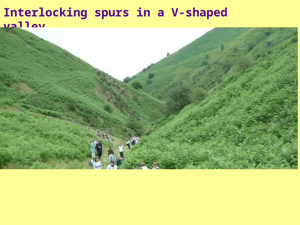
Interlocking spurs in a V-shaped valley

Techniques! – 1. Field sketching….
Produce an annotated fieldsketch to show that this is part of an upland river valley.

The formation of a V shaped valley and interlocking spurs
The river high above its _____ level has lots of potential _____. It tries to reach its base level by _____ downwards – _____ erosion.
As the river cuts down, weathering attacks the _____ sides. This breaks up and loosens the _____ and _____.
The loosened material creeps down the _____ because of _____, or is washed into the river by _____ (slope transport). The _____ carries it away.
The river _____ downwards as the load (_____, _____ and _____ particles) are bounced and scraped along the channel _____.
The result is a _____ sided _____ that has the shape of a “__”. In this valley the river is forced to _____ its way around protruding _____ – these are called _______ spurs.
Missing words: hillside; valley; slope; river; base; energy; interlocking; V; wind; vertical; soil; steep; steep; rock; rock; stones; gravity; eroding; erodes; boulders; rainwater; bed
Missing words: hillside; valley; slope; river; base; energy; interlocking; V; wind; vertical; soil; steep; steep; rock; rock; stones; gravity; eroding; erodes; boulders; rainwater; bed
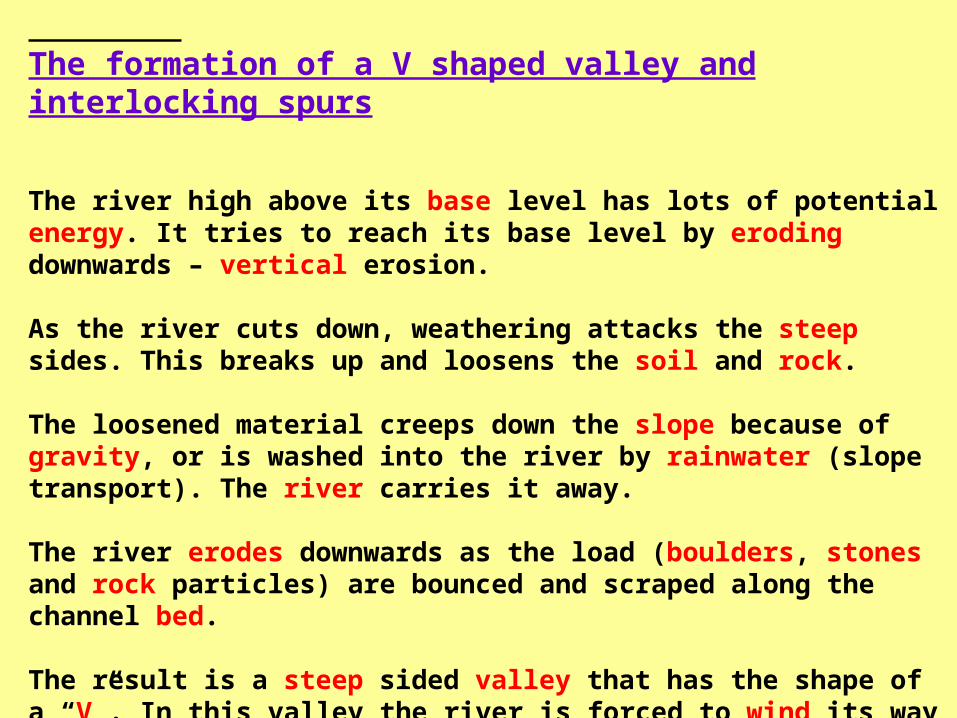
The formation of a V shaped valley and interlocking spurs
The river high above its base level has lots of potential energy. It tries to reach its base level by eroding downwards – vertical erosion.
As the river cuts down, weathering attacks the steep sides. This breaks up and loosens the soil and rock.
The loosened material creeps down the slope because of gravity, or is washed into the river by rainwater (slope transport). The river carries it away.
The river erodes downwards as the load (boulders, stones and rock particles) are bounced and scraped along the channel bed.
The result is a steep sided valley that has the shape of a “V”. In this valley the river is forced to wind its way around protruding hillsides – these are called interlocking spurs.

River valleys – examination questionsIdentify v-shaped valleys and spurs of land.


Examination question
X
Y
Study the map of a river valley below:
Sketch a cross-section of the river valley from X to Y.
Label two features of this river valley.
State at what stage of a river’s course you would expect to find this type of valley. Give reasons for your answer.
Height (m)
X Y

Definition: A representation of a vertical section across and through a landscape or landscape feature, e.g. a cross-valley profile. It is used to show what an area looks like between two points.
What is a cross-section?5 mins

0
100
200
300
400
500
National Parkboundary
MeldonQuarry
You might be asked to draw one or possibly add detail to an existing cross section, e.g. to label on human or natural features such as roads, rivers, buildings/sites, forests etc.
Heig
ht
ab
ove s
ea level (m
etr
es)
A cross section from an OS map would look like this….

Step 1Put the edge of
the piece of paper along the line of section X
to Y

Step 2Mark on the paper the start and finish
points (X and Y)

Step 3Mark on the paper
where the contours cross the
edge

Step 4Put some of the
contour values on the paper250
240220
200
200
270
350400
436

Step 5Mark on the river
(blue line)
250240
220200
200
270
350400
436
National Parkboundary
MeldonQuarry

0
100
200
Step 6Draw some axes
ready to plot your cross section onto.
Remember you
will need to draw the vertical axis so
that you can include the
highest point.
300
400
500
The horizontal axis should be the same length as X to Y on your piece of paper.
X Y

250 240220200 200
270350
400436
National P
ark
boundary Meldon
Quarry
0
100
200
Step 7Transfer the paper
to your cross section frame
300
400
500

250 240220200 200
270350
400436
National P
ark
boundary Meldon
Quarry
0
100
200
Step 8Plot the points
300
400
500

250 240220200 200
270350
400436
National P
ark
boundary Meldon
Quarry
0
100
200
Step 9Join the points
with a curved line
300
400
500

250 240220200 200
270350
400436
National P
ark
boundary
0
100
200
Step 10Mark on the river
300
400
500
National Parkboundary
Meldon
Quarry
MeldonQuarry

Examination question
X
Y
Study the map of a river valley below:
Sketch a cross-section of the river valley from X to Y.
Label two features of this river valley.
State at what stage of a river’s course you would expect to find this type of valley. Give reasons for your answer.
Height (m)
X Y
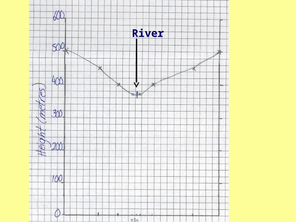
River

Exam question• Study figure 1, which is a field sketch showing the upper
course of a river.a) Name two features from figure 1 to show that this is in the
river’s upper course (2 marks)b) Explain how these two features were formed (6 marks)
Figure 1
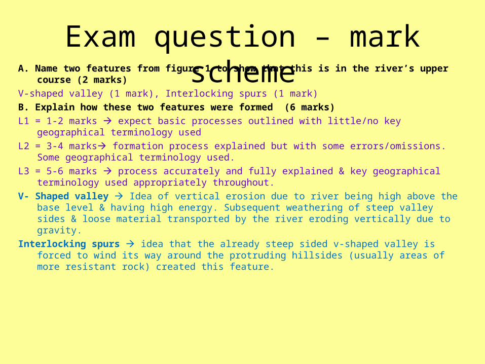
Exam question – mark schemeA. Name two features from figure 1 to show that this is in the river’s upper
course (2 marks)V-shaped valley (1 mark), Interlocking spurs (1 mark)B. Explain how these two features were formed (6 marks)L1 = 1-2 marks expect basic processes outlined with little/no key geographical
terminology usedL2 = 3-4 marks formation process explained but with some errors/omissions.
Some geographical terminology used.L3 = 5-6 marks process accurately and fully explained & key geographical
terminology used appropriately throughout.V- Shaped valley Idea of vertical erosion due to river being high above the base
level & having high energy. Subsequent weathering of steep valley sides & loose material transported by the river eroding vertically due to gravity.
Interlocking spurs idea that the already steep sided v-shaped valley is forced to wind its way around the protruding hillsides (usually areas of more resistant rock) created this feature.