horizon 2020 space information day, lisbon - ncp...
TRANSCRIPT

European GNSS Applications in Horizon 2020
Horizon 2020 Space Information Day, Lisbon15 September 2016
Vojtech FortEuropean GNSS Agency


European GNSS Agency (GSA)
The European GNSS Agency (GSA) today:
• Staff: about 145
• Nationalities: 21
• Headquarters: Prague (since September 2012)
• Other Locations: St Germain en Laye, Swanwick, Torrejon

DOWNSTREAM VALUE CHAIN
Integrated approach: understanding the market, stimulating the demand, creating a competitive EU offer
4
E-GNSS USER ADOPTION
EU PUBLIC BENEFITS
MARKET SEGMENTS
Road
LBS
Aviation
Rail
Maritime
Agriculture
Surveying & Mapping
Timing & Synchronization
Support EU
of Services, applications
and receivers
COMPETITIVE OFFER
Fundamental Elements
User Satisfaction
•Understand market and user needs and satisfaction
DEMAND & ADOPTION
Stimulate
• EGNSS added Value
• Cooperate with receiversand aps
• Roadmaps with stakeholders
• Support EC policies
Bodiesinfluencingthe market
Navigation Signal
Providers
Chipset,receiver
DevicesContent &
AppsService
providers

55Source: http://www.reancon.com/

A 4 billion GNSS devices global market, expected to further grow in the future both in volume…
Growth will be observed
in all regions
12.7%
CAGR

…and revenues, driven by mass market segments
Both core and
enabled revenues
slowly mature
Cumulated revenues
dominated by LBS

GNSS FP7 1st, 2nd and 3rd Calls
• 13 patents/registered trademarks (also on-going)• 45 commercialised products/services • 80 Working prototypes• 115 Demonstrations and more is expected…
• 3 calls for proposals on GNSS Applications
• Portfolio of ~90 R&D projects with a budget of ~€70 mil.• 425 beneficiaries
• 40% of GNSS funds to SMEs vs. EU FP7 average <15%• Business coaching for SMEs: Business expert support
GNSS FP7 results in a nutshell

Source: www.visionaryadvertising.co.uk

H2020-Galileo-2014-2015 Calls
1st Call 2nd Call
Budget available 40.2 mln EUR 25.0 mln EUR
Budget requested 174.3 mln EUR 192.2 mln EUR
No of projects funded 27 13
No of projects submitted 105 89
No of applicants 775 634
26% success rate 15% success rate
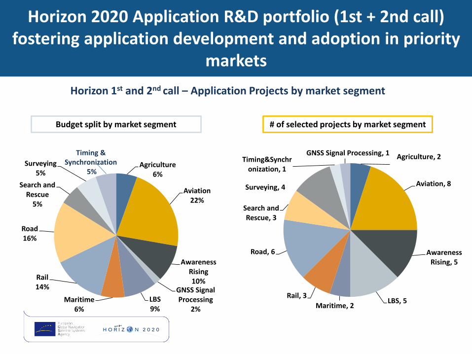
Horizon 2020 Application R&D portfolio (1st + 2nd call) fostering application development and adoption in priority
markets
Horizon 1st and 2nd call – Application Projects by market segment
Agriculture, 2
Aviation, 8
Awareness Rising, 5
LBS, 5Maritime, 2
Rail, 3
Road, 6
Search and Rescue, 3
Surveying, 4
Timing&Synchronization, 1
GNSS Signal Processing, 1
Agriculture6%
Aviation22%
Awareness Rising10%
GNSS Signal Processing
2%
LBS9%
Maritime6%
Rail14%
Road16%
Search and Rescue
5%
Surveying5%
Timing & Synchronization
5%
Budget split by market segment # of selected projects by market segment

5 LivesEGNSS for helicopters in distress situations
ERSAT EAVEuropean GNSS for safety-critical railway applications
ELAASTICComprehensive EGNSS-enhanced location platform
DEMETRAEGNSS for resilience to Timing & Sync operations
Foster ITSGalileo for Intelligent Transportation Systems
spyglassGalileo for Vessel Traffic Management Systems
H2020 1st CallEXAMPLES
• Total Cost: € 2.120 mil• EU Contribution: € 1.573 mil
• Total Cost: € 1.313 mil• EU Contribution: € 1.069 mil
• Total Cost: € 2.590 mil• EU Contribution: € 1.813 mil
• Total Cost: € 4. 366 mil• EU Contribution: € 3.506 mil
• Total Cost: € 2.501 mil• EU Contribution: € 1.751 mil
• Total Cost: € 5.536 mil• EU Contribution: € 4.252 mil
12
RAIL
LBS
PROFESSIONAL/TIMING
ROAD
MARITIME
AVIATION

SAT406M - Application providing an end-to-end solution based on the
SAR/Galileo service using the Return-Link-Message (RLM)
13
Achievements so far:
• PLB beacon prototype successfully
tested
• MEOLUT ground infrastructure
successfully tested
• PLB and MEOLUT- fully integrated
via Galileo satellites
The project develops an EGNSS application
to improve the Search and Rescue of people
in distress, comprising:
• An improved Personal Locator Beacon
(PLB)
• A new communication method enhancing
the standard communication between the
PLB and the SAR/Galileo system.
COREGAL - Combined Positioning-Reflectometry Galileo Code Receiver for Forest management
Achievements so far:
• Successful trials of GNSS-P+R
receiver
• Data Processing Algorithms
for biomass data developed
• Data Processing Algorithms
for Carbon stock estimation
developed
Innovative platform enabling low-cost, high-
accuracy and unprecedented use of airborne
GNSS-Reflectometry (GNSS-R) for biomass
retrieval and related and relevant applications
as carbon mapping and land management.
New positioning techniques enabled by E5
signals and modulations in an emerging
market
Examples of H2020 Galileo 1st call projects
Portuguese coordinator: DEIMOS ENGENHARIA

Source: www.visionaryadvertising.co.uk
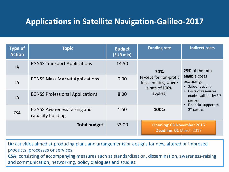
Applications in Satellite Navigation-Galileo-2017
Type of Action
Topic Budget(EUR mln)
Funding rate Indirect costs
IAEGNSS Transport Applications 14.50
70% (except for non-profit legal entities, where
a rate of 100% applies)
25% of the total eligible costs excluding:• Subcontracting• Costs of resources
made available by 3rd
parties • Financial support to
3rd parties
IAEGNSS Mass Market Applications 9.00
IAEGNSS Professional Applications 8.00
CSAEGNSS Awareness raising and capacity building
1.50 100%
Total budget: 33.00
IA: activities aimed at producing plans and arrangements or designs for new, altered or improved products, processes or services.CSA: consisting of accompanying measures such as standardisation, dissemination, awareness-raising and communication, networking, policy dialogues and studies.
Opening: 08 November 2016Deadline: 01 March 2017

Compulsory Preliminary Business PlanGALILEO-1,2,3
What: Demonstrate the commercial potential of the product and/or service and
describe how this potential will be realised.
Why: It is an input to evaluate the Impact criteria.
How: Template available in the participant portal.
• Define the proposed offering: the product and/or service and target market sector.
• Review the market sector: structure, size, drivers, market and technology trends.
• Assess the competition: main players, their current offerings and market share.
• Describe the innovation of the proposed offering in the context of the competition and the sector’s needs
• Summarise potential business model(s) together with possible entry price(s) and costs
• Assess the key risks to market entry and possible options for risk mitigation.
• Outline, graphically, the roll-out of the offering: timescale, sales growth and market share.
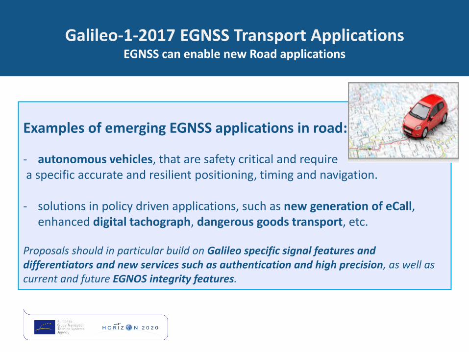
Galileo-1-2017 EGNSS Transport ApplicationsEGNSS can enable new Road applications
Examples of emerging EGNSS applications in road:
- autonomous vehicles, that are safety critical and requirea specific accurate and resilient positioning, timing and navigation.
- solutions in policy driven applications, such as new generation of eCall, enhanced digital tachograph, dangerous goods transport, etc.
Proposals should in particular build on Galileo specific signal features and differentiators and new services such as authentication and high precision, as well as current and future EGNOS integrity features.

Galileo-1-2017 EGNSS Transport ApplicationsMaritime is ready to benefit from EGNSS
Examples of emerging EGNSS applications in maritime and inland waterways (including the Arctic):
• vessels navigation, • traffic management and surveillance, • search and rescue, • port operations, • custom fraud control, • fisheries monitoring.
Proposals should in particular build on the use of current and future EGNOS dedicated services for maritime, and the Search and Rescue service of Galileo, other Galileo differentiating features and services, such as authentication, and high precision.

Galileo-1-2017 EGNSS Transport ApplicationsEGNSS will enhance the GNSS offering to Rail
Examples of emerging EGNSS applications in rail:
- train signalling and control, contributing to the evolution and cost competitiveness of the European Rail Traffic Management System
- non-safety-critical applications, such as passenger information system, asset management, etc.
Synergy and complementarity with the Shift 2 Rail Joint Undertaking and other initiatives shall be clearly identified.
Proposals should in particular build on the current and future EGNOS integrity services and multi-constellation, multifrequency, and specific signal features of Galileo that improves position performances in the challenging railway environment (e.g. urban parts).

Galileo-1-2017 EGNSS Transport ApplicationsAviation is an early EGNOS adopter and will further benefit from Galileo
20
Examples of emerging EGNSS applications in aviation:
• EGNSS solutions for navigation, surveillance and communication inall phases of flight (also for determination of location of aircraft in distress):
• GNSS based PBN (Performance Based Operations)• advanced operations for approach and landing benefitting from robust vertical
guidance and LPV-200/CAT1 services• Surveillance applications:
• ADS-B (Automatic Dependent Surveillance Broadcast) and use of reliable PVT forintegrity,
• precise positioning, orientation of remotely piloted aerial systems (RPAS)
Synergy and complementarity with the Sesar Joint Undertaking and other initiatives shall be clearlyidentified.Proposals should build on multi-constellation/multi-frequency, current and future EGNOS integrityfeatures and service levels, as well as integration of multi-constellation enabling capabilities.

Galileo-2-2017 EGNSS Mass Market ApplicationsEGNSS will contribute to better performance in LBS
Examples of emerging EGNSS applications in mass market:
• Smart Cities (examples): • cross-modal mobility and new emerging “mobility as a service” approach, in which the user
does not buy a vehicle or a public transport ticket, but a service to comply with her/his mobility needs
• innovative telematics applications in which the positioning, timing and navigation are used both to deliver the mobility service and to calculate a fair price based on the actual use of it.
• Internet of things (examples): • exploiting the interconnectivity of uniquely identifiable devices and the availability of their
location.
• Applications for commercial LBS, such as: secure financial transactions; mobile workforce management, tracking solutions; augmented reality; social networking and sport.
• Applications for social LBS, such as: safety and emergency (E112), e-health (health services more and more connected), and solutions supporting visual and mobility of impaired people.

Examples of emerging EGNSS applications in professional applications:
- Agriculture:
Automated machine guidance, precision farming and machine control and field boundary measurements.
- Surveying and Mapping:
Land survey, marine survey, cadastral and geodesy, and construction.
- Timing and Synchronisation:
Telecommunications, power generation and finance.
- Other professional applications:
clearly demonstrating amongst others the contribution of EGNSS differentiators, the potential of integration with earth observation data, and the future commercial potential.
Galileo-3-2017 EGNSS Professional ApplicationsEGNSS differentiators are already recognised in professional market segments

Galileo-4-2017 EGNSS Awareness raising and capacity building
Scope:
- support building of industrial relationships by gathering private and public institutions around services offered by EGNSS and related applications
- support the competitiveness of EU industry by identifying strategic partners and by developing market opportunities
- support to incentive schemes should foster the emergence of new downstream applications based on either Galileo and/or EGNOS and therefore to support the EU GNSS industry

R&D for GALILEO & EGNOS mobile applicationand FP7 brochure
To highlight the tangibleresults coming out of the 7thFramework Programme(FP7) and H2020 1st Callserving as inspiration forthose participating in H2020,the GSA launches its newEGNSS R&D application:
FP7 brochure offering an overview of results from GNSS research under the
FP7 R&D programme:
http://www.gsa.europa.eu/sites/default/files/FP7-brochure2015_7.pdf
http://www.gsa.europa.eu/rd-for-galileo-egnos-app
GNSS Projects’ Portfoliohttp://www.gsa.europa.eu/r-d/gnss-project-portfolio

4th issue of GNSS Market Report
Download your own copy at: http://www.gsa.europa.eu/2015-gnss-market-report
The 4th edition of the GSA’s GNSS Market Report is a comprehensive source ofknowledge on the GNSS global market for:
• European GNSS downstream industry and SMEs (e.g. for their business planning and strategic investments decisions)
• Venture capitals and other financial institutions
• European Commission
• Member States governments and policy makers
• … and GSA, as fundamental input to our adoption strategy
More than 10 000 downloads 1 month after publication
2010 2012 2013
25

EGNSS applications developmentSynergies with other H2020 calls
Transport
•MG-2.3-2016: New and improved transportconcepts in waterborne transport
•MG-5.2-2017: Innovative ICT solutions forfuture logistics operations
•MG-6.2-2016: Large-scale demonstration(s)of cooperative ITS
•ART-01-2017: ICT infrastructure to enablethe transition towards road transportautomation
•ART-02-2016: Automation pilots forpassenger cars
Information and Communication Technologies
•ICT-16-2017: Big data PPP: researchaddressing main technologychallenges of the data economy
Space(other than Applications in Satellite Navigation Call)
•COMPET-7-2017: Technology transferand business generators
•SME instrument SMEInst-04 -2016-2017: Engaging SMEs in space researchand development
•Other actions:
•Galileo Evolution, Mission and Servicerelated R&D activities
•EGNOS, Mission and Service relatedR&D activities
•GNSS evolution, infrastructure-relatedR&D activities
Secure societies – Protecting freedom and security of Europe and
its citizens
•SEC-01-DRS-2016: Integrated tools for response planning and scenario building
•SEC-19-BES-2016: Data fusion for maritime security applications
