holocene climate evolution of the ugii nuur basin, mongolia · 988 holocene climate evolution of...
TRANSCRIPT

ADVANCES IN ATMOSPHERIC SCIENCES, VOL. 25, NO. 6, 2008, 986–998
Holocene Climate Evolution of the Ugii Nuur Basin, Mongolia
Wolfgang SCHWANGHART∗1, Brigitta SCHUTT2, and Michael WALTHER3
1Department of Environmental Sciences, University of Basel, Basel, Switzerland
2Institute of Geographical Sciences, Freie Universitat Berlin, Berlin, Germany
3Mongolian Landscape Research Centre, National University of Mongolia, Ulaanbataar, Mongolia
(Received 16 May 2007; revised 29 February 2008)
ABSTRACT
In order to evaluate the Holocene palaeoenvironmental evolution of the Ugii Nuur basin, central Mongolia,investigations on chemical and mineralogical properties of lacustrine sediments were carried out on a 630cm sediment core from lake Ugii Nuur. The interpretation of the record is based on a principal componentanalysis (PCA) of the elemental composition of the samples. The results show that lacustrine depositionstarted at 10.6 kyr BP. Low lake level conditions were identified during the Early Holocene (10.6–7.9 kyrBP). The Mid Holocene (7.9–4.2 kyr BP) was characterized by generally higher lake levels and thus highermoisture supply, but it experienced strong climatic fluctuations. Arid conditions prevailed from 4.2–2.8 kyrBP and were followed by a stable, more humid phase until today.
Key words: lake sediments, palaeoclimate, Central Asia, Mongolia, Holocene
Citation: Schwanghart, W., B. Schutt, and M. Walther, 2008: Holocene climate evolution of the Ugii Nuurbasin, Mongolia. Adv. Atmos. Sci., 25(6), 986–998, doi: 10.1007/s00376-008-0986-4.
1. Introduction
Moisture availability is one of the most importantnatural factors governing almost all aspects of soci-etal and economical life. In East and Central Asia,moisture supply is mainly attributed to the Indianand South-East Asian Monsoon. These wind systemsare highly variable in space and time driven by inter-actions between the global atmosphere, oceans, landand ice systems as well as conditions imposed by theconcurrence of the East Asian land mass and solar ra-diation (An et al., 2000).
A key to the understanding of the complex controlson these wind systems are records of climate changethat are accessed and interpreted by palaeoenviron-mental research. A large number of studies on theChinese loess sequences (e.g., Maher and Thomson,1991; Madsen et al., 1998; Fang et al., 1999; Zhu etal., 2004; Liu et al., 2005), lake systems (e.g., Waltheret al., 2003; Wunnemann et al., 2005; Prokopenko etal., 2007), ice cores (e.g., Thompson et al., 1997; Yaoet al., 1997) and speleothems (e.g., Wang et al., 2001)have provided insight into the climatic and environ-
mental evolution of the regions affected by monsoonvariability and, thus, increased the understanding oftheir sensitivity to climatic change.
Moreover, current research on the human dimen-sion of monsoon variability increased the understand-ing of climate and human interactions in monsoonalAsia (Rost et al., 2003; An et al., 2005; Fu and deVries, 2006; Yancheva et al., 2007). This issue be-comes particularly challenging when considering theenvironmental changes and problems that monsoonalAsia faces, especially in its arid and semi-arid regionswhich are likely to increase in the future driven byclimate change (Liu and Diamond, 2005).
An understanding of the prehistorical and histori-cal climate and human interactions in central Mongoliais the aim of ongoing research conducted by archaeolo-gists from University of Bonn (Germany) and geogra-phers from Freie Universitat Berlin (Germany). Theirresearch focuses on the Orkhon Valley which has ex-perienced a vicissitudinous history of human influence(Rosch et al., 2005) since various cultures preferredthis region as a settlement location due to its strategicposition (Bemmann et al., 2008). Moreover, its situa-
∗Corresponding author: Wolfgang SCHWANGHART, [email protected]

NO. 6 SCHWANGHART ET AL. 987
tion in the semi-arid steppe region makes it highly vul-nerable to climate change (Gunin et al., 1999; Tarasovet al., 1999; Dulamsuren et al., 2005).
Since the climatic forces, their variability, and theenvironmental history of this region are still poorly un-derstood, this paper addresses the paleoenvironmentalhistory of the Ugii Nuur basin in the Orkhon Val-ley during the Holocene. We accomplish this goalby analyzing a lake sediment core spanning the entireHolocene history of Lake Ugii Nuur. The interpreta-tion is based on chemical and mineralogical propertiesof the lake sediments.
2. Regional setting
Lake Ugii Nuur is located at 47◦44′N and 102◦46′Eat an elevation of 1328 m EGM96 (see Fig. 1). Thefreshwater lake has a surface area of ca. 26 km anda maximum depth of 16 m. Presently, the lake is de-scribed as a thermally stratified, oligo- to mesotrophic,dimictic lake with a visible depth of 7.3 m. The metal-imnion is found between 10 and 12 m above an unsta-ble hypolimnion (Volker, 2005). The lake basin openstowards the 12–20 km wide Orkhon valley in the west-ern part of the catchment. The Old Orkhon River(Chogschin Gol) constitutes the inlet in the westernpart of the lake. This perennial river drains an areaof 4655 km that includes the eastern branches of theKhangay Mountains. The outlet is located northwestof the inlet and joins the Orkhon River after a distanceof 7 km (Fig. 1). This water course is only ephemer-ally active due to overflow from Ugii Nuur. During thetwo field campaigns in summer 2005 and 2006 it wasdried out or marshy.
While terrain in the southern and eastern drainagebasin is characterized by undulating relief, the north-ern part is hilly to mountainous with elevations up to1600 m. Bedrock in the basin consists to a large ex-tent of aeolian silts and fine sands covering Carbonif-erous shists and shales that outcrop along ridges andsteep slopes (Schwanghart and Schutt, 2008). Clifflines along the southern and eastern shore are partlycomposed of conglomerates of probably late Cretaciousand Tertiary age (Traynor and Sladen, 1995; Sladenand Traynor, 2000). Soils are weakly developed anddifferentiated by Leptosols, Regosols and Kastanozemsaccording to their position in the relief (Haase, 1983).
The Ugii Nuur basin is characterized by an ex-tremely continental climate. Kharkhorin, a town lo-cated about 60 km south of Lake Ugii Nuur (Fig. 1),has a mean annual air temperature around zero and ayearly precipitation amount of approx. 290 mm (1962–83). The continentality causes a strong seasonality intemperature and precipitation. Mean January air tem-
peratures of −18.2◦C contrast mean July air tempera-tures of 16.8◦C. Highest precipitation rates generatedby heavy rainfalls are found in summer, while precip-itation in winter (November to March) occurs mostlyin solid form and rarely exceeds 10 mm per month.The study site is situated within the area of dry, grasssteppes (Hilbig, 1995; Opp and Hilbig, 2003) and isdominated by grasses (Cleistogenes, Stipa), forbs (Al-lium), and shrubs (Artemisia, Caragana) while treesare generally lacking.
3. Methods
3.1 Sediment extraction and analysis
The sediment core Ugi-4 was drilled at the deep-est point of Ugii Nuur in 2003 using a Usinger pistoncorer. The core has a length of 630 cm and was sam-pled with an interval of 10 cm and a resolution of 2cm. Prior to chemical and mineralogical analysis, thesamples were dried at 50◦C, screened of componentslarger 2 mm and homogenized in an agate disk swingmill (Lieb-Technik). We used a conductrometric car-bon analyzer (Woesthoff, detection limit=0.02 mass-%C) to determine the total and inorganic carbon (TIC)content. Total organic carbon (TOC) content was cal-culated as the difference of both values. Mineralogicalcompounds were analyzed by X-ray powder diffractionusing a copper kα-tube (PW1729/40, Phillips) from2θ= 2◦ − 52◦ and a step width of 2θ=0.01◦ with eachstep measured for one minute. Contents of mineralcomponents were recorded semi-quantitatively (vol.-%) using the software package Phillips X’Pert High-scorev 1.0b (PW3209). After preparing samples us-ing aqua regia and microwave digestion, we analyzedthe element composition (Ca, Cr, Cu, Fe, K, Mg,Mn, Na, Ni, Pb, PO4, S, Sr) by inductively coupledplasma atomic emission spectroscopy (ICP-AES, Op-tima 3000, Perkin Elmer).
3.2 Age control
Age control was established by atomic mass spec-trometer (AMS) 14C dating of three bulk sedimentsamples in 210, 510 and 580 cm depth by the Poz-nan Radiocarbon Laboratory. Since there is a lack ofcarbonatic rocks in the lake catchment we exclude aninflux of old carbon skewing the 14C/12C ratio and,thus, the dates were not corrected for a reservoir ef-fect. Calibration of radiocarbon dates was performedusing CalPal, a software for calibration and visualiza-tion developed and distributed by the Prehistory Insti-tute at University of Cologne (http://www.calpal.de).The calibration curve CalPal2005-SFCP was used. Allages referred to hereafter are calibrated years unlessotherwise noted.

988 HOLOCENE CLIMATE EVOLUTION OF THE UGII NUUR BASIN, MONGOLIA VOL. 25
Fig. 1. Map of the Ugii Nuur basin.
3.3 Statistical analysis
We applied a principal component analysis (PCA)(Davis, 2002) based on the correlation matrix to re-duce the complexity of the elemental composition ofthe samples. Since compositions only provide infor-mation on the relative magnitudes of the componentsand are subject to a constant sum constraint (CSC),interpretations involving absolute values may be bi-ased (Aitchison, 1999; Aitchison and Egozcue, 2005).Aitchison (1986) presents a solution to the problem ofapplying multivariate statistics with CSC data by us-ing centered log-ratios, which are linear combinationsof the compositional variables. Log-ratios remove thenegative bias in the covariance and correlation matri-ces introduced by the use of CSC data and avoid falla-cious interpretations that emerge from raw componentanalysis (Kucera and Malmgren, 1998). The log-ratioof an observation i of a sample S is calculated by
y(i) = ln(x(i)/gs) , (1)
where gs is the geometric mean of a sample calculatedby
gs = e(lnx1+ln x2+...+ln xN )/N (2)
and N is the number of variables constituting the com-position in the sample. The presence of zero elements
requires a zero-replacement procedure that Aitchison(1986) implements by replacing all zero elements by avalue lower than the precision under which the originaldata were generated (Kucera and Malmgren, 1998).
Prior to log-ratio transformation the unit of allchemical parameters was set to µg g−1. Since our datadoes not add up to a constant sum (not all elementsare determined by the aforementioned analysis tech-niques), the remaining proportion was included as anadditional variable, but was not included in the PCA.
In order to enhance the interpretability of the de-rived principal components (PCs) as real endmembersthey were transformed using Varimax rotation. Thisorthogonal rotation generates an even distribution ofvariance on the PCs by maximizing the variance of thefactor loadings. Geometrically, the factor loadings arethe cosines between the variables and the factors andequal the correlation coefficient. For an interpretationof the factors 50% declared variance (modulus of factorloading >0.7) was set as boundary value. The factorscores were estimated using regression in order to gaininsight into the chronological behavior of the PCs.
4. Results
4.1 Sediment stratigraphy
The sediments of the core UGI-4 (Fig. 2) can bedistinguished according to three major stratigraphical

NO. 6 SCHWANGHART ET AL. 989
Fig. 2. Lithography and age model of the core Ugi-4.
units characterized by fluvial sands at the bottom (sec-tion 12, 13), clay to silty, organic rich sediments in sec-tions 2–11 and organic poor loam in the overlying sed-iments (section 1, <140 cm). Sections 2–11 are mainlydetermined by alternating carbonate contents locallyreaching calcite concentrations up to 30%. A fish scalefound in the sediment core in 158–160 cm depth (sed-iment age of approx. 2800 yr BP corresponding to theage model below) was identified by Joris Peters (LMUMunich) as remnant of a perch (Perca sp.), most likelyPerca fluviatilis.
4.2 Age model
The AMS 14C dates are 3535±30 (Lab. No.: Poz-16767), 7770±50 (Poz-16847) and 9210±50 yr BP(Poz-16768), respectively. Calibration of these datesyields 3809±57, 8538±55 and 10382±84 calibrated(cal.) yr BP. An age model was established by lin-ear interpolation as displayed in Fig. 2. A linear ex-trapolation at the core end yields a sediment bottomage of 11400 yr BP. Sedimentation rates derived fromthe linear interpolation range from 0.43 to 0.63 mmyr−1. Correspondingly, the sampling scheme of 10 cmintervals sampling rate and 2 cm resolution is to beequated with a sampling rate of 160–230 years, whereeach sample integrates over 31–46 years.
4.3 Element composition
Element compositions of the sediments are dis-played in Fig. 3. Sequences of TIC, Ca, Mn and Srfeature various correlative peaks. TIC values range
between the detection limit of 0.02 and 3.66 mass-%.Sections of increased TIC concentrations prevail from530 to 468 cm and 220 to 158 cm depth. Further sin-gle peaks with amounts up to 2 mass-% are found in310, 370, 580 and 590 cm depth. Except for slightlyincreased TIC concentrations at the lake bottom, TICcontent remains at the detection limit above 150 cmdepth. Fe, K, Mg, Cr, Cu and Ni show a negative cor-relation with TIC and TIC-related elements (Fig. 3).Below 600 cm depth a sharp drop in concentrationscoincides with change towards a different depositionalenvironment as indicated by the lithography.
TOC concentrations range between 2 and 8 mass-% above 600 cm depth. Below 600 cm the concentra-tions rapidly decline below the detection limit. Peaksin TIC are partly associated with TOC increases. TheTOC graph is characterized by distinct fluctuationsthroughout the profile. Coherent periods of low TOCvalues below 3 mass-% are found from 580 to 538 cm,470 to 378 cm and above 150 cm. Some peaks of TOCoverlap with increased sulphur concentrations. Herethree distinct periods with notably increased S con-centrations are observed at 600 to 480 cm, 380 to 310and 220 to 130 cm depth. Positive deflexions in TOCconcentrations are frequently associated with negativepeaks in K and Mg. Na and PO4 concentrations areplaced together in one group as both feature a trendthroughout the profile. Na has low values of 0.5 mgg−1 at the base of the core and then escalates to 1.5mg g−1 at 590 cm depth. From here a relatively con-tinuous decrease towards 0.5 mg g−1 in the upper part
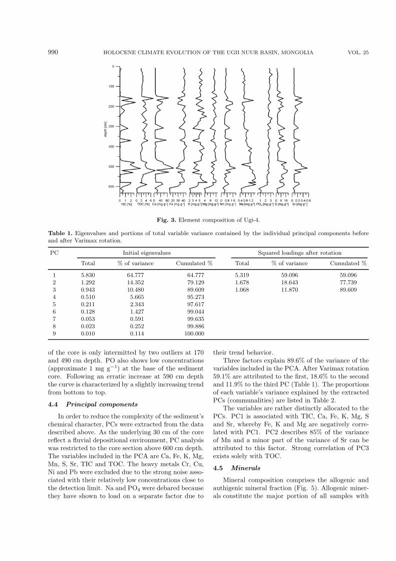
990 HOLOCENE CLIMATE EVOLUTION OF THE UGII NUUR BASIN, MONGOLIA VOL. 25
Fig. 3. Element composition of Ugi-4.
Table 1. Eigenvalues and portions of total variable variance contained by the individual principal components beforeand after Varimax rotation.
PC Initial eigenvalues Squared loadings after rotation
Total % of variance Cumulated % Total % of variance Cumulated %
1 5.830 64.777 64.777 5.319 59.096 59.0962 1.292 14.352 79.129 1.678 18.643 77.7393 0.943 10.480 89.609 1.068 11.870 89.6094 0.510 5.665 95.2735 0.211 2.343 97.6176 0.128 1.427 99.0447 0.053 0.591 99.6358 0.023 0.252 99.8869 0.010 0.114 100.000
of the core is only intermitted by two outliers at 170and 490 cm depth. PO also shows low concentrations(approximate 1 mg g−1) at the base of the sedimentcore. Following an erratic increase at 590 cm depththe curve is characterized by a slightly increasing trendfrom bottom to top.
4.4 Principal components
In order to reduce the complexity of the sediment’schemical character, PCs were extracted from the datadescribed above. As the underlying 30 cm of the corereflect a fluvial depositional environment, PC analysiswas restricted to the core section above 600 cm depth.The variables included in the PCA are Ca, Fe, K, Mg,Mn, S, Sr, TIC and TOC. The heavy metals Cr, Cu,Ni and Pb were excluded due to the strong noise asso-ciated with their relatively low concentrations close tothe detection limit. Na and PO4 were debared becausethey have shown to load on a separate factor due to
their trend behavior.Three factors explain 89.6% of the variance of the
variables included in the PCA. After Varimax rotation59.1% are attributed to the first, 18.6% to the secondand 11.9% to the third PC (Table 1). The proportionsof each variable’s variance explained by the extractedPCs (communalities) are listed in Table 2.
The variables are rather distinctly allocated to thePCs. PC1 is associated with TIC, Ca, Fe, K, Mg, Sand Sr, whereby Fe, K and Mg are negatively corre-lated with PC1. PC2 describes 85% of the varianceof Mn and a minor part of the variance of Sr can beattributed to this factor. Strong correlation of PC3exists solely with TOC.
4.5 Minerals
Mineral composition comprises the allogenic andauthigenic mineral fraction (Fig. 5). Allogenic miner-als constitute the major portion of all samples with

NO. 6 SCHWANGHART ET AL. 991
Fig. 4. Compositional and log-ratio transformed Fe, Mn and Fe-Mn ratio. Minus signs signalsections in the core with negative correlation of Fe and the Fe-Mn ratio, and vice versa.
Fig. 5. Chronology of principal components (PC) and occurrences of minerals.

992 HOLOCENE CLIMATE EVOLUTION OF THE UGII NUUR BASIN, MONGOLIA VOL. 25
Table 2. Factor loadings (eigenvectors) and communali-ties of log-ratio transformed variables after Varimax ro-tation. Bold numbers indicate factor loading higher0.7/lower −0.7.
Element Factor loading Communality
PC1 PC2 PC3
Mg −0.970 −0.081 −0.041 0.950Fe −0.947 −0.214 0.054 0.946K −0.928 −0.231 −0.089 0.923TIC 0.882 0.262 −0.181 0.879Ca 0.852 0.461 −0.105 0.950Sr 0.752 0.574 −0.092 0.903S 0.727 −0.332 0.145 0.660Mn 0.144 0.923 −0.012 0.872TOC −0.008 −0.031 0.991 0.983
a dominance of quartz and feldspars. Semi-quantitatively determined proportions of quartz andfeldspars range between 46 and 94 vol.-% with a me-dian of 91 vol.-% for all samples. A differentiation ofthe feldspar group yields mainly polymorphs of alkalifeldspars (orthoclase, sanidine and microcline) and theend-member albite. Further silicates detected as tracesare chlorite, hornblende, kaolinite and muscovite.
Calcite is found in 23 samples with concentrationsranging from 1 to 37 vol.-%. Pyrite and gypsum couldbe identified in several samples albeit only as traces.Occurrences of pyrite and gypsum are predominantlyrestricted to the lower and middle part of the profile(Fig. 5) and are mostly associated with calcite. Mono-hydrocalcite (MHC) is found in two samples in 160 and310 cm depth. While in the latter sample, MHC onlyvestigially occurs, its proportion in the 160 cm sampleis higher than 20 vol.-%.
5. Discussion
5.1 Element and mineral composition
5.1.1 Interpretation of principal componentsElement and mineral compositions vary in the Ugii
Nuur lake sediments. The PCA on the log-ratio trans-formed element compositions depicts that their vari-ance is basically explained by one factor. Positive load-ings on PC1 exist with TIC, Ca, Sr and S, elementsthat mainly reflect the authigenic mineral productionin the lake. Positive values of PC1 are consequentlyinterpreted to reflect warm limnic conditions and highbiomass production in the lake. This interpretation isbased on several aspects. The authigenic production ofTIC is subject to various physical lake conditions (tem-perature, CO2, solute concentration) that are partlylinked to biomass production (Hakanson and Jansson,1983; Dean, 1999; Xiao et al., 2006). Optimal con-
ditions for the incorporation of endogenic carbonateminerals in sediments are derived from a combinationof these parameters. The water temperature of shal-low lakes in summer is generally high and the waterbody is unstratified due to a lack of sufficient depthto form a hypolimnion in summer, and thus promotescalcite sedimentation. Calcite solubility is further de-creased by increasing pH values during algal blooms(Dean, 1999).
Increased biological activity, however, simultane-ously leads to an increase of respiratory CO2 produc-tion. This inverse effect on carbonate solubility is pre-sumably buffered by allogenic contribution of calcite tothe lake (Hakanson and Jansson, 1983). Due to an ab-sence of carbonate rocks in the Ugii Nuur catchment,the input of calcite derived from bedrock solution canbe excluded. Yet, it was shown by Lehmkuhl and Lang(2001) and Grunert and Lehmkuhl (2004) that car-bonatic loess-like deposition plays an important rolein the sediment budget of the Mongolian steppe re-gions. Direct aeolian deposition in the lake and in-put of calcium carbonate or its solutes by removal ofaeolian deposits by water erosion may be an impor-tant carbonate source for lacustrine carbonate precip-itation. Moreover, the proportion of allogenic calcitein the lake is linked to the lake volume. The assump-tion of a decreased lake volume during high values ofPC1 is further consolidated by a preponderant cooc-currence of authigenic minerals like pyrite and gypsum(Fig. 5). While sulfides are formed under highly re-duced conditions and thus indicate productive lakes(Hakanson and Jansson, 1983), sulfates are primar-ily precipitated from solutions with densities higherthan 1.115 g cm−1 and thus indicate increased salinitydriven by evaporation (Langbein, 1961; Sonnenfeld,1984; Schutt, 2004b).
The elements K, Mg and Fe negatively relate toPC1 and are interpreted as lithogenous or allogenicsediment fraction. Despite the removal of possible di-lution effects on the data by log-ratio transformation,the diametrical behavior between authigenic and allo-genic sediments remains. Thus, negative values of PC1are related to high lake levels and increased detrital in-put. The results from the upper part of the sedimentcore reflect this situation and are confirmed by the cur-rent state of the water body that is characterized asoligo- to mesotrophic and thermally stratified (Volker,2005). Higher lake levels than present are expected toexceed the present state by a maximum of only twometers due to a lack of damming to the west of thebasin and a consequent overflow to the Orkhon River(Fig. 1).
Mn variability is assigned to an independent mech-anism described by PC2. Mn, in lacustrine sediments,

NO. 6 SCHWANGHART ET AL. 993
is sensitive to lake and catchment conditions and isoften compared to Fe by means of the Fe-Mn ratio(Mackereth, 1966; Boyle, 2001; Schutt, 2004b). Acomparison of Fe and the Fe-Mn ratio (Fig. 4) re-veals that the relation between both elements variesalong the core. While in the upper part Fe and theFe-Mn ratio graphs exhibit an opposing course, par-allel behavior prevails in the lower part of the core.As aforementioned, Fe is related to the lithogenoussediment fraction, which indicates a strong erosionalmode of transport of this element (Hartmann andWunnemann, 2008). The parallel course of Fe and Mnin the upper part of the core is characterized by high Feand low Mn concentrations in comparison to the con-centration range of both. Mn concentrations duringthis phase presumably equal those of the lithosphericbackground (Mackereth, 1966). The underlying partof the core (>160 cm depth, >2.8 kyr BP) is character-ized by much stronger fluctuations of both elements.Sharp increases in Mn contents are always accompa-nied by negative Fe-concentrations. As low contents ofFe indicate an attenuation of the lithogenic sedimentfraction, the correlating high contents of Mn point to-wards a different source of Mn. We suggest that thesephases are marked by low allothigenic input by sur-face runoff and that the lake is predominantly fed bygroundwater. Since Mn in soils is more easily mobi-lized than iron under reducing conditions (Schlichtingand Schweikle, 1980), groundwater is enriched in dis-solved Mn, which is subsequently incorporated in thelake sediments. This assumption is consolidated by themedium PC2 loadings of Ca and Sr (Table 2), that arehighly mobile in soils, too (Scheffer, 2002). As a con-sequence we interpret PC2 to reflect solute transportfrom the catchment via groundwater into the lake. Apositive trend of PC2 thus indicates aquifer filling andsoil formation during the Holocene.
PC3 reflects the mechanism behind TOC accumu-lation in the lake sediments. TOC enrichment canbe attributed to increased autochthonous bioproduc-tion, dedrital input from the catchment (Dunne et al.,1991; Boyle, 2001; Xiao et al., 2006) and preserva-tion, when covering rates exceed diagenetic decom-position rates (Lerman, 1979; Schutt, 2004a). Thesediverse mechanisms impede paleoclimatological inter-pretations inferred from TOC concentrations withoutadditional source signals (e.g., N, δ13C) (Meyers, 1994;Xiao et al., 2006; Hartmann and Wunnemann, 2008).Still, various correlative peaks of TIC and TOC sug-gest a synsedimentary mechanism during some peri-ods. Since TIC is interpreted to negatively correspondwith waterdepth, TOC concentrations during low lakelevels may largely reflect increased biological produc-tivity (Scheffer, 2004). Yet, relatively high TOC con-
centrations (∼2%) prevalent during high lake levelsand suggest the additional influence of terrestrial or-ganic matter (plant detritals, humins) transported tolake via groundwater or overland flow (Xiao et al.,2006).
5.1.2 MonohydrocalciteA rather rare mineral found in 160 and 310 cm
depth is MHC (CaCO3·H2O). The natural occurrenceof this hydrated calcium carbonate was first reportedby Sapozhnikov and Tsvetkov (1959) in the form ofcalcareous incrustations on the bottom near the shoreof Lake Issyk-Kul, Kirgistan. It has been found byMarschner (1969) at the mouths of cold water pipes,by Taylor (1975) as a main constituent in beach rocksin southern Australia and by Fischbeck and Muller(1971) and Harmon (1983) in speleothems. A marineoccurrence of MHC has been first reported by Dahland Buchardt (2006) for south-west Greenland.
MHC formation is attributed to several mecha-nisms. Laboratory experiments suggest a preferableMHC genesis at water temperatures near the freezingpoint (Lippmann, 1973) and natural occurrences haveoften been associated with cold water (Marschner,1969; Fischbeck and Muller, 1971; Harmon, 1983).Yet, biological activity is also regarded as an impor-tant mechanism behind MHC formation (Broughton,1972; Taylor, 1975; Skinner et al., 1977). Since it wasshown that MHC tends to convert to anhydrous car-bonates even at low temperatures (several authors inLippmann, 1973), a stable basis for the interpretationof MHC as proxy for lake temperatures is lacking.
5.1.3 Paleoenvironmental implicationsDatings point to an onset of lacustrine sedimenta-
tion in the Ugii Nuur lake at 10.6 kyr BP after a periodof fluvial deposition most likely by the Orkhon or OldOrkhon River [Phase 1 (P1)] (Walther and Gegeen-suvd, 2005). The temporal placement is in good agree-ment with other lakes in NW China and Mongoliathat predominantly featured a negative water balanceor were dried out during the Last Glacial Maximum(LGM) and the beginning of the Holocene (Grunertand Dasch, 2004; Hartmann and Wunnemann, 2008;Karabanov et al., 2004; Tarasov et al., 1999; Walther,1999; Walther et al., 2003; Wunnemann et al., 1998;Wunnemann and Hartmann, 2002; Yang et al., 2004).Rapid increases in lake levels may be attributed tomeltwater generated by the glacier retreat after theLGM (Walther, 1999). Yet, the occurrence of glaciersin the Ugii Nuur basin was limited to the higher re-gions of the Khangay Mountains (Lehmkuhl et al.,2004). Lake level rise may also be linked to the abruptmonsoon intensification at ∼11.5 kyr BP (Sirocko et

994 HOLOCENE CLIMATE EVOLUTION OF THE UGII NUUR BASIN, MONGOLIA VOL. 25
al., 1993; Wang et al., 1999; Herzschuh, 2006).PC1 scores indicate a generally lower lake level
than today with high biological productivity duringthe early phase of lake evolution from 10.6 to 7.9 kyrBP (P2, Fig. 5). Low values of PC3 point to effi-cient decomposition during the underlying half of thissection but might also indicate a poor availability oforganic matter from the catchment. The findings ofgypsum, pyrite and generally low but partly moder-ate concentrations of calcite in this section supportthe notion of the high lake internal productivity anda lack of outflow and evaporation driven water bal-ance during this time. From 10.1 to 9.1 kyr BP PC1values around zero point at a well-balanced ratio be-tween deposition of authigenic and allogenic materialduring moderate lake levels. Lake desiccation from 9.1to 7.9 kyr BP is in good agreement with a markeddry phase observed in NW China and the TibetanPlateau (Herzschuh, 2006; Wunnemann et al., 2003;Xiao et al., 2004; Hartmann and Wunnemann, 2008)and might be attributed to the 8.2 kyr BP event (Al-ley and Agustsdottir, 2005). These results, however,disagree with evidences of wetter conditions in NWMongolia inferred from the rise of boreal evergreen andconifer pollen since 9 kyr BP (Tarasov et al., 2000).
A subsequent phase of high lake levels interruptedby a period with pronounced fluctuations occurredfrom 7.9 to 4.2 kyr BP (P3, Fig. 5). During thistime allogenic material is dominantly supplied to thelake bottom indicating increased runoff. Vegetationduring this time was characterized by an increase inwoodland (Rosch et al., 2005). A marked increase inPC3 suggests the importance of detrital organic in-put and its poor decomposition during this period. Inarid and semi-arid China most sites archive a rela-tively wet climate during the Mid Holocene (7–5 kyrBP) (e.g., Xiao et al., 2004, 2006) but spatial pat-terns among different lakes are inconsistent (An et al.,2006; Hartmann and Wunnemann, 2008). High wa-ter levels are reported for most Mongolian lakes dur-ing the Mid-Holocene (Dorofeyuk and Tarasov, 1998;Grunert et al., 2000; Tarasov et al., 2000). Yet, Pecket al. (2002) and Fowell et al. (2003) indicate a MidHolocene dry climate for Lake Telmen. Correspondingto the irregular spatial pattern of moisture availability,the temporal lake level pattern as observed in P3 andthe sporadic occurrences of pyrite and gypsum duringthis period reflect a rather unstable development of thelake during the Mid Holocene and a higher samplingrate is required to reliably resolve these fluctuations.
From 4.2 to 2.8 kyr BP (P4, Fig. 5) a phase ofreduced lake levels is indicated by PC1. Constant cal-cite precipitation and occurrences of pyrite and gyp-sum suggest high biological activity and salinity of the
lake water during this time. This period agrees fairlywell with the temporal placement of a dry phase from5.4 to 2.9 kyr BP observed in Mongolia (Walther etal., 2003) and northwest China (Xiao et al., 2004) andcorrelates with a rapid decline of forest vegetation anda re-establishment of steppe as the dominant vegeta-tion type in the Hoton-Nuur area at 4 kyr BP (Tarasovet al., 2000). Still, evidence for a more humid phasein Central Mongolia during this period is provided byPeck et al. (2002).
The Ugii Nuur record indicates stable high lakelevels from 2.8 kyr BP to present (P5, Fig. 5),thus suggesting enhanced moisture supply during theLate Holocene. Although an onset of more humidconditions is reported during the beginning of theLate Holocene for areas in NW China and Mongo-lia (Hartmann and Wunnemann, 2008; Peck et al.,2002; Walther et al., 2003), evidence for a trend to-wards dryer conditions during the last three millenniais found in many parts of Central Asia except for thoseinfluenced by the westerlies (Herzschuh, 2006).
The chronology of the factor scores and theirpalaeoenvironmental interpretation partly agrees withprevious findings from Central and East Asia. Never-theless, they partly disagree with findings from othersites located relatively close to the Ugii Nuur basin[e.g., Lake Telmen (Peck et al., 2002; Fowell et al.,2003)]. This highlights the problems associated withthe ability to transfer the findings to a larger areaand, thus, points to the difficulties that arise fromthe deduction of information on the general paleoen-vironmental conditions. Spatially variable palaeoenvi-ronmental conditions in NW China are mainly asso-ciated with the southward retreat of the South-EastAsian Monsoon since 9 kyr BP (An et al., 2000) andthe response of the Indian Monsoon and the wester-lies (Herzschuh, 2006). Still, extreme differences existamong sites located close to each other (Herzschuh,2006). Partly, the alternating timings of dry and wetintervals may be explained by site-specific sensitivi-ties to moisture supply (An et al., 2006). These site-specific sensitivities may be derived from the presentaridity of a location (An et al., 2006), but processeslike aquifer response to moisture supply should alsobe taken into account (Hartmann and Wunnemann,2008). Hence, in order to reduce the uncertainties as-sociated with the interpretation of lake sediments, notonly a larger quantity of lake proxies should be consid-ered. Moreover, spatially distinct terrestrial archivesshould be investigated to understand catchment re-sponse to climate variability.
6. Conclusions and outlook
Lacustrine deposits of Lake Ugii Nuur provide valu-

NO. 6 SCHWANGHART ET AL. 995
able insights into the palaeoenvironmental evolutionof the Ugii Nuur basin and the adjacent Orkhon Val-ley. During the Holocene the lake environment alteredbetween open and closed lake conditions. Lacustrinedeposition started at 10.6 kyr BP. Low lake level condi-tions were identified during the Early Holocene (10.6–7.9 kyr BP). It is proposed that lakes in this areabenefitted from increased discharge induced by glaciermelting in the Khangay Mountains during a warm butrelatively arid period. The Mid Holocene (7.9–4.2 kyrBP) was characterized by generally higher lake levelsand thus increased moisture supply. Yet, this periodwas prone to strong climatic fluctuations. More aridconditions prevailed from 4.2–2.8 kyr BP and were fol-lowed by a stable, more humid phase until today.
Archaeological findings provide evidences for theearliest human settlements in the Orkhon Valley morethan two thousand years (∼250 yr BP) ago. Sincethen, the Orkhon Valley was a preferred settlement lo-cation of various cultures (Weiers, 2005). Remnants ofwalls, necropoles and memorials found all over the areatestify this long history of human interference with theenvironment in this region (Bemmann et al., 2008). Aclimax phase of human activities in this area representsthe late Medieval, when Dschingis Khan chose the fandeposits of the Upper Orkhon Valley as locality forthe Mongolian capital Karakorum (Qara Qorum). Aquestion always was: Why was this area chosen againand again? We conclude, that, among many reasons,the three millennia lasting, favorable and stable en-vironmental conditions in this area were at least animportant factor.
Acknowledgements. We would like to thank Mrs.
E. Krings and Dr. H.-P. Roper for assistance in X-ray
diffractometry and Prof. Dr. Joris Peters from LMU Mu-
nich for the identification of the fishscale.
REFERENCES
Aitchison, J., 1986: The Statistical Analysis of Compo-sitional Data. Monographs on Statistics and AppliedProbability, Chapman & Hall, Ltd., London, 416pp.
Aitchison, J., 1999: Logratios and natural laws in com-positional data analysis. Mathematical Geology, 31,563–580.
Aitchison, J., and J. J. Egozcue, 2005: Compositionaldata analysis: Where are we and where should we beheading. Mathematical Geology, 37, 829–850.
Alley, R. B., and A. M. Agustsdottir, 2005: The 8kevent: Cause and consequences of a major Holoceneabrupt climate change. Quaternary Science Reviews,24, 1123–1149.
An, C.-B., L. Tang, L. Barton, and F.-H. Chen, 2005: Cli-mate change and cultural response around 4000 calyr B.P. in the western part of Chinese Loess Plateau.
Quaternary Research, 63, 347–352.An, C.-B., Z.-D. Feng, and L. Barton, 2006: Dry or hu-
mid? Mid-Holocene humidity changes in arid andsemi-arid China. Quaternary Science Reviews, 25,351–361.
An, Z., 2000: The history and variability of the EastAsian paleomonsoon climate. Quaternary ScienceReviews, 19, 171–187.
An, Z., S. P. Porter, J. E. Kutzbach, X. Wu, S. Wang,X. Liu, X. Li, and W. Zhou, 2000: AsynchronousHolocene optimum of the East Asian monsoon. Qua-ternary Science Reviews, 19, 743–762.
Bemmann, J., E. Pohl, B. Schutt, and W. Schwang-hart, 2008: Archeological findings in the Upperand Middle Orchon Valley and their geographicalsetup. Mongolian-German Qara Qorum-Expedition,Bemmann et al., Eds., FAAK (Forschungen zurArchaologie Auaereuropaischer Kulturen), in press.
Boyle, J. F., 2001: Inorganic geochemical methods inpaleolimnology. Tracking Environmental Change Us-ing Lake Sediments. Physical and Geochemical Meth-ods. Vol. 2, Developments in Paleoenvironmental Re-search, W. M. Last and J. P. Smol, Kluwer, Eds.,Dordrecht, Boston, London, 83–142.
Broughton, P. L., 1972: Monohydrocalcite in speleo-thems: An alternative interpretation. Contributionsto Mineralogy and Petrology, 36, 171–174.
Dahl, K., and B. Buchardt, 2006: Monohydrocalcite inthe Arctic Ikka Fjord, SW Greenland: First Re-ported Marine Occurrence. Journal of SedimentaryResearch, 76, 460–471.
Davis, J. C., 2002: Statistics and Data Analysis in Ge-ology. John Wiley & Sons, New York, Chichester,Brisbane, 3 Ed., 638pp.
Dean, W. E., 1999: The carbon cycle and biogeochemicaldynamics in lake sediments. Journal of Paleolimnol-ogy, 21, 375–393.
Dorofeyuk, N. I., and P. E. Tarasov, 1998: Vegetation andlake levels in Northern Mongolia in the last 12,500years as indicated by data of pollen and diatom anal-yses. Stratigraphy and Geological Correlation, 6, 70–83.
Dulamsuren, C., M. Hauck, and M. Muhlenberg, 2005:Ground vegetation in the Mongolian taiga forest-steppe ecotone does not offer evidence for the humanorigin of grasslands. Applied Vegetation Science, 8,149–154.
Dunne, T., W. Zhang, and B. Aubry, 1991: Effects ofrainfall, vegetation and microtopography on infiltra-tion and runoff. Water Resour. Res., 27, 2271–2285.
Fang, X. M., and Coauthors, 1999: Asian summer mon-soon instability during the past 60,000 years: mag-netic susceptibility and pedogenic evidence from thewestern Chinese Loess Plateau. Earth and PlanetaryScience Letters, 168, 219–232.
Fischbeck, R., and G. Muller, 1971: Monohydrocalcite,hydromagnesite, nesquehonite, dolomite, aragoniteand calcite in speleothems of the Frankische Schweiz,Western Germany. Contributions to Mineralogy and
996 HOLOCENE CLIMATE EVOLUTION OF THE UGII NUUR BASIN, MONGOLIA VOL. 25
Petrology, 33, 87–92.Fowell, S. J., B. C. Hansen, J. A. Peck, P. Khosbayar,
and E. Ganbold, 2003: Mid to late Holocene climateevolution of the Lake Telmen basin, north centralMongolia, based on palynological data. QuaternaryResearch, 59, 353–363.
Fu, C., and F. P. de Vries, 2006: Initial science plan ofthe Monsoon Asia Integrated Study, MAIRS workingpaper series, Vol. 1, International Program Office,MAIRS, 86pp.
Grunert, J., and D. Dasch, 2004: Dynamics and evolutionof dune fields on the northern rim of the Gobi Desert(Mongolia). Zeitschrift Fur Geomorphologie Suppl.,133, 81–106.
Grunert, J., and F. Lehmkuhl, 2004: Aeolian sedimen-tation in arid and semi-arid environments of West-ern Mongolia. Paleoecology of Quaternary Drylands,W. Smykatz-Kloss and P. Felix-Henningsen, Eds.,Vol. 102, Lecture Notes in Earth Sciences, Springer,Berlin, New York, Toronto, 195–218.
Grunert, J., F. Lehmkuhl, and M. Walther, 2000: Pale-oclimatic evolution of the Uvs Nuur basin and adja-cent areas (Western Mongolia). Quaternary Interna-tional, 65–66, 171–192.
Gunin, P. D., E. A. Vostokova, N. I. Dorofeyuk, P. E.Tarasov, and C. C. Black, 1999: Vegetation Dynam-ics of Mongolia, Geobotany. Vol. 26, Kluwer, Dor-drecht, Boston, London, 233pp.
Haase, G., 1983: Beitrage zur Bodengeographie der Mon-golischen Volksrepublik. Physisch-GeographischeStudien in Asien, Barthel et al., Eds., 34, 231–367.(in German)
Hakanson, L., and M. Jansson, 1983: Principles of LakeSedimentology. Springer, Berlin, Heidelberg, NewYork, 316pp.
Hartmann, K., and B. Wunnemann, 2008: Hydrologi-cal changes and Holocene climate variations in NWChina, inferred from lake sediments of Juyanze palae-olake by factor analyses. Quaternary International,doi: 10.1016/j.quaint.2007.06.037.
Harmon, R. S., 1983: The mineralogy of CastleguardCave, Columbia Icefields, Alberta, Canada. Arcticand Alpine Research, 15, 503–516.
Herzschuh, U., 2006: Palaeo-moisture evolution in mon-soonal Central Asia during the last 50,000 years.Quaternary Science Reviews, 25, 163–178.
Hilbig, W., 1995: The Vegetation of Mongolia. SPB Aca-demic Publishing, 260pp.
Karabanov, E. B., and Coauthors, 2004: Ecologicalcollapse of Lake Baikal and Lake Hovsgol ecosys-tems during the Last Glacial and consequences foraquatic species diversity. Palaeogeography, Palaeocli-matology, Palaeoecology, 209, 227–243.
Kucera, M., and B. A. Malmgren, 1998: Logratio trans-formation of compositional data—A resolution of theconstant sum constraint. Marine Micropaleontology,34, 117–120.
Langbein, W. B., 1961: Salinity and hydrology of closedlakes. U. S. Geology Survey Professional Paper, 421,
1–20.Lehmkuhl, F., and A. Lang, 2001: Geomorphological in-
vestigations and luminescence dating in the southernpart of the Khangay and the Valley of the Gobi Lakes(Central Mongolia). Journal of Quaternary Science,16, 69–87.
Lehmkuhl, F., M. Klinge, and G. Stauch, 2004: Theextent of Late Pleistocene glaciations in the Altaiand Khangai Mountains. Quaternary Glaciations Ex-tent and Chronology. Part III: South America, Asia,Africa, Australasia, Antarctica, J. Ehlers and P. L.Gibbard, Eds., Elsevier, Amsterdam, Boston, Heidel-berg, Vol. 2, Developments in Quaternary Science,243–254.
Lerman, A., 1979: Geochemical Processes, Water andSediment Environment. John Wiley and Sons, NewYork, 480pp.
Lippmann, F., 1973: Sedimentary Caronate Minerals,Minerals, Rocks and Inorganic Materials. MonographSeries of Theoretical and Experimental Studies, Vol.6, Springer, Berlin, Heidelberg, New York, 228pp.
Liu, J., and J. Diamond, 2005: China’s environment in aglobalizing world. Nature, 453, 1179–1186.
Liu, Q., S. K. Banerjee, M. J. Jackson, C. Deng, Y. Pan,and R. Zhu, 2005: Inter-profile correlation of the Chi-nese loess/paleosol sequences during Marine OxygenIsotope Stage 5 and indications of pedogenesis. Qua-ternary Science Reviews, 24, 195–210.
Mackereth, F. J. H., 1966: Some chemical observationson post-glacial lake sediments. Philosophical Trans-actions of the Royal Society B, 250, 165–213.
Madsen, D. B., L. Jingzen, R. G. Elston, X. Cheng, R. L.Bettinger, G. Kan, P. J. Brantingham, and Z. Kan,1998: The loess/paleosol record and the nature ofthe younger dryas climate in Central China. Geoar-chaeology: An International Journal, 13, 847–869.
Maher, B. A., and R. Thomson, 1991: Mineral magneticrecord of the Chinese loess and paleosols. Geology,19, 3–6.
Marschner, H., 1969: Hydrocalcite (CaCO3·H2O) andnesquehonite (MgCO3·3H3O) in carbonate scales.Science, 165, 1119–1121.
Meyers, P. A., 1994: Preservation of elemental and iso-topic source identification of sedimentary organicmatter. Chemical Geology, 114, 289–302.
Opp, C., and W. Hilbig, 2003: Verbreitungsregeln vonBoden und Pflanzengesellschaften im nordlichen Zen-tralasien unter besonderer Berucksichtigung des Uvs-Nuur-Beckens. Petermanns Geographische Mitteilun-gen, 147, 16–23. (in German)
Peck, J. A., P. Khosbayar, S. J. Fowell, R. B. Pearce, S.Ariunbileg, B. C. Hansen, and N. Soninkhishig, 2002:Mid to Late Holocene climate change in north centralMongolia as recorded in the sediments of Lake Tel-men. Palaeogeography, Palaeoclimatology, Palaeoe-cology, 183, 135–153.
Prokopenko, A. A., G. K. Khursevich, E. V. Bezrukova,M. I. Kuzmin, X. Boes, D. F. Williams, S. A. Fe-denya, N. V. Kulagina, P. P. Letunova, and A. A.
NO. 6 SCHWANGHART ET AL. 997
Abzaeva, 2007: Paleoenvironmental proxy recordsfrom Lake Hovsgol, Mongolia, and a synthesis ofHolocene climate change in the Lake Baikal water-shed. Quaternary Research, 68, 2–17.
Rosch, M., E. Fischer, and T. Markle, 2005: Hu-man diet and land use in the time of the Khans—Archaeobotanical research in the capital of the Mon-golian Empire, Qara Qorum, Mongolia. VegetationHistory and Archaeobotany, 14, 485–492.
Rost, K. T., J. Bohner, and K.-H. Portge, 2003: Land-scape degradation and desertification in the Mu UsShamo, Inner Mongolia-an ecological and climaticproblem since historical times? Erdkunde, 57, 110–125.
Sapozhnikov, D. G., and A. I. Tsvetkov, 1959: Precipita-tion of hydrous calcium carbonate on the bottom ofLake Issyk-Kul. Dokl. Akad. Nauk SSSR, 124, 402–405.
Scheffer, F., 2002: Lehrbuch der Bodenkunde/Scheffer/Schachtschabel. Spektrum, Heidelberg, Berlin, 15Ed., 593pp. (in German)
Scheffer, M., 2004: Ecology of Shallow Lakes, Popula-tion and Community Biology Series, Vol. 22, KluwerAcademic Publishers, Dordrecht, Boston, London,394pp.
Schlichting, E., and V. Schweikle, 1980: Interpedontranslocations and soil classification. Soil Science,130, 200–204.
Schutt, B., 2004a: The chemistry of playa-lake-sedimentsas a tool for the reconstruction of Holocene environ-mental conditions—A case study from the centralEbro basin. Paleoecology of Quaternary Drylands,W. Smykatz-Kloss and P. Felix-Henningsen, Eds..Vol. 102, Lecture Notes in Earth Sciences, Springer,Berlin, New York, Toronto, 5–30.
Schutt, B., 2004b: Zum holozanen Klimawandel der zen-tralen Iberischen Halbinsel, Relief Boden Palaoklima.Vol. 2, Borntrager, Berlin, Stuttgart, 347pp. (in Ger-man)
Schwanghart, W., and B. Schutt, 2008: Holocene mor-phodynamics in the Ugii Nuur basin, Mongolia-insights from a sediment profile and 1D electrical re-sistivity tomography. Zeitschrift fur Geomorphologie,in press.
Sirocko, F., M. Sarntheim, H. Erlenkeuser, H. Lange,M. Arnold, and J. C. Duplessy, 1993: Century-scaleevents in monsoonal climate over the past 24,000years. Nature, 364, 322–324.
Skinner, H. C. W., G. W. Osbaldiston, and A. N. Wilner,1977: Monohydrocalcite in a guinea pig bladderstone, a novel occurrence. American Mineralogist,62, 273–277.
Sladen, C., and J. J. Traynor, 2000: Lakes during the evo-lution of Mongolia. Lake Basins Through Space andTime, E. H. Gierlowski-Kordesch and K. R. Kelts,Eds., Vol. 46, American Association of PetroleumGeologists Studies in Geology, 35–57.
Sonnenfeld, P., 1984: Brines and Evaporites. AcademicPress, Orlando, 613pp.
Tarasov, P., N. Dorofeyuk, and E. Metel’Tseva, 2000:Holocene vegetation and climate changes in Hoton-Nur basin, northwest Mongolia. Boreas, 29, 117–126.
Tarasov, P. E., and Coauthors, 1999: Last Glacial Max-imum climate of the former Soviet Union and Mon-golia reconstructed from pollen and plant macrofossildata. Climate Dyn., 15, 227–240.
Taylor, G. F., 1975: The occurrence of monohydrocalcitein two small lakes in the south-east of South Aus-tralia. American Mineralogist, 60, 690–697.
Thompson, L. G., and Coauthors, 1997: Tropical climateinstability: The last glacial cycle from a Quighai-Tibetan ice core. Science, 276, 1821–1825.
Traynor, J. J., and C. Sladen, 1995: Tectonic and strati-graphic evolution of the Mongolian People’s Republicand its influence on hydrocarbon geology and poten-tial. Marine and Petroleum Geology, 12, 35–52.
Volker, J., 2005: Hydrographie und aktuellerGewasserzustand. Ugii Nuur (Central Mongolia) Pa-leoenvironmental Studies of Lake Level Fluctuationsand Holocene Climate Change, M. Walther and T.Gegeensuvd, Eds., Vol. 2, Geographica-Oekologica,MOLARE Research Centre, Ulaanbaatar, 2–6. (inGerman)
Walther, M., 1999: Befunde zur jungquartarenKlimaentwicklung rekonstruiert am Beispiel derSeespiegelstande des Uvs Nuur-Beckens (NW-Mongolei). Die Erde, 130, 131–150. (in German)
Walther, M., and T. Gegeensuvd, 2005: Ugii Nuur (Cen-tral Mongolia) Paleo Environmental Studies of LakeLevel Fluctuations and Holocene Climate Change,Geographica-Oekologica, Vol. 2, MOLARE ResearchCentre, Ulaanbaatar, 36pp.
Walther, M., B. Wunnemann, and A. Tschimeksaichan,2003: Seen und Palaoseen in der Mongolei und Nord-westchina. Petermanns Geographische Mitteilungen,147, 40–47. (in German)
Wang, L., and Coauthors, 1999: East Asian monsoon cli-mate during the Late Pleistocene: High-resolutionsediment records from the South China Sea. MarineGeology, 156, 245–284.
Wang, Y. J., H. Cheng, R. L. Edwards, Z. S. An, Y.Wu, J, C.-C. Shen, and J. A. Dorale, 2001: A high-resolution absolute-dated Late Pleistocene monsoonrecord from Hulu Cave, China. Science, 294, 2345–2348.
Weiers, M., 2005: Steppe und Steppenreiche bis Cing-gis Khan. Dschingis Khan und seine Erben, Hirmer,36–38. (in German)
Wunnemann, B., and K. Hartmann, 2002: Morphody-namics and Paleohydrography of the Gaxun NurBasin, Inner Mongolia, China. Zeitschrift fur Geo-morphologie Suppl., 126, 147–168.
Wunnemann, B., H. Pachur, and J. Li, 1998:Chronologie der pleistozanen und holozanenSeespiegelschwankungen des Gaxun Nur / Sogo Nurund Baijian Hu, Innere Mongolei, Nordwestchina.Petermanns Geographische Mitteilungen, 142,191–206. (in German)
998 HOLOCENE CLIMATE EVOLUTION OF THE UGII NUUR BASIN, MONGOLIA VOL. 25
Wunnemann, B., F. Chen, F. Riedel, C. Zhang, S. Mis-chke, G. Chen, D. Demske, and J. Ming, 2003:Holocene lake deposits of Bosten Lake, southern Xin-jiang, China. Chinese Science Bulletin, 48, 1429–1432.
Wunnemann, B., K. Hartmann, N. Altmann, U. Ham-bach, and H. J. Pachur, 2005: Interglacial and glacialfingerprints from lake deposits in the Gobi Desert,NW China. The Climate of the Past Interglacials.Developments in Quaternary Science, Sirocko et al.,Eds., Elsevier, Amsterdam, 323–347.
Xiao, J., Q. Xu, T. Nakamura, X. Yang, W. Liang, andY. Inouchi, 2004: Holocene vegetation variation inthe Daihai Lake region of north-central China: A di-rect indication of the Asian monsoon climatic history.Quaternary Science Reviews, 23, 1669–1679.
Xiao, J., J. Wu, B. Si, W. Liang, T. Nakamura, B. Liu,and Y. Inouchi, 2006: Holocene climate changes inthe monsoon/arid transition reflected by carbon con-
centration in Dahai Lake of Inner Mongolia. TheHolocene, 16, 551–560.
Yancheva, G., and Coauthors, 2007: Influence of the in-tertropical convergence zone on the East Asia Mon-soon. Nature, 445, 74–77.
Yang, X., K. T. Rost, F. Lehmkuhl, Z. Zhenda, and J.Dodson, 2004: The evolution of dry lands in northernChina and in the Republic of Mongolia since the LastGlacial Maximum. Quaternary International, 118–119, 69–85.
Yao, T., L. G. Thompson, Y. Shi, D. Qin, K. Jiao, Z.Yang, L. Tian, and E. M. Thompson, 1997: Climatevariation since the last interglaciation recorded in theGuliya ice core. Science in China (D), 40, 662–668.
Zhu, R., Q. Liu, and M. J. Jackson, 2004: Paleoenviron-mental significance of the magnetic fabrics in Chineseloess-paleosols since the last interglacial (<130 ka).Earth and Planetary Science Letters, 221, 55–69.