hkh-hycos regional flood information system – … centre for integrated mountain development...
TRANSCRIPT
International Centre for Integrated Mountain Development
Kathmandu, Nepal
Mandira Singh Shrestha
HKH-HYCOS regional flood information system – and its benefits to SAsiaFFG system First Steering Committee Meeting (SCM 1) New Delhi, INDIA 26-28 April 2016

Outline of presentation
• Flood disasters in the Himalayan region Key issues
• HKH HYCOS achievements • Development of a regional flood outlook
Why a regional flood outlook? Flood outlook model
– Data inputs – Data assimilation – Calibration and validation – Flood outlook/flood forecast – Performance of the model
• Opportunities for cooperation • Role of ICIMOD in the SAsiaFFG system
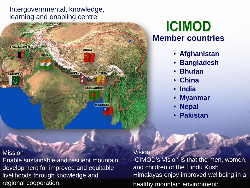
• Afghanistan• Bangladesh• Bhutan• China• India• Myanmar• Nepal• Pakistan
Member countries
Intergovernmental, knowledge, learning and enabling centre
Vision ICIMOD’s Vision is that the men, women, and children of the Hindu Kush Himalayas enjoy improved wellbeing in a healthy mountain environment;
Mission Enable sustainable and resilient mountain development for improved and equitable livelihoods through knowledge and regional cooperation.

Disaster statistics from 1985-2014 Himalayan region countries
On average, annually more than 24,000 people are killed and 160 million affected by natural disasters .
The region has an average of 60 disaster events each year
(Source: EM-DAT – The OFDA/CRED International Disaster Database)
150 232
10
684
428
32 89
141
0
100
200
300
400
500
600
700
800
Afg
hani
stan
Ban
glad
esh
Bhu
tan
Chi
na
Indi
a
Mya
nmar
Nep
al
Pak
ista
n
Num
ber o
f eve
nts

One-third of these disasters are floods
• Transboundary floods - shared vulnerability across national borders • Globally, 10% of all floods are transboundary, but they cause over 30%
of all flood causalities and displace close to 60% of all those displaced by floods (Bakker 2006)
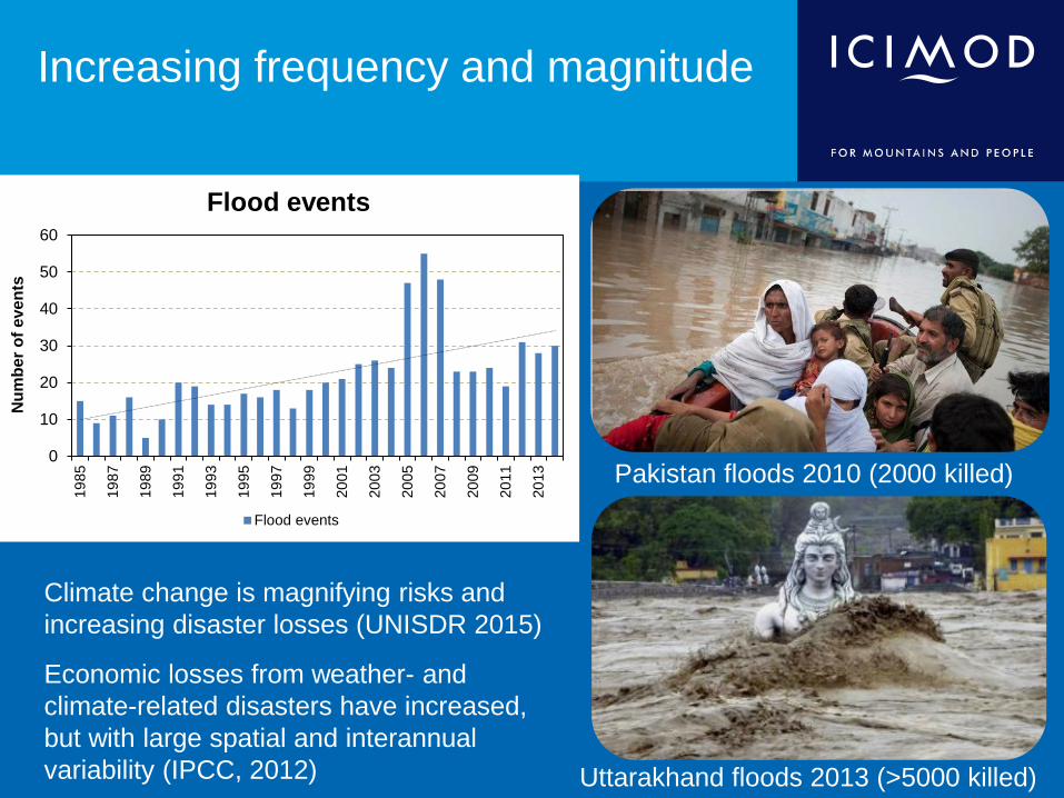
Increasing frequency and magnitude
Pakistan floods 2010 (2000 killed)
Uttarakhand floods 2013 (>5000 killed)
0
10
20
30
40
50
60
1985
1987
1989
1991
1993
1995
1997
1999
2001
2003
2005
2007
2009
2011
2013
Num
ber o
f eve
nts
Flood events
Flood events
• Climate change is magnifying risks and
increasing disaster losses (UNISDR 2015)
• Economic losses from weather- and climate-related disasters have increased, but with large spatial and interannual variability (IPCC, 2012)
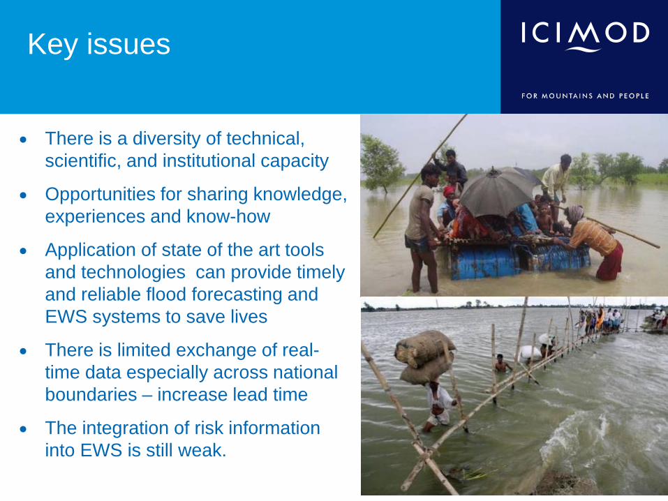
• There is a diversity of technical, scientific, and institutional capacity
• Opportunities for sharing knowledge, experiences and know-how
• Application of state of the art tools and technologies can provide timely and reliable flood forecasting and EWS systems to save lives
• There is limited exchange of real-time data especially across national boundaries – increase lead time
• The integration of risk information into EWS is still weak.
Key issues

Innovation in technologies for end to end flood early warning system
• Advancement in technology : real-time data through sensors.
• Data transmission through CDMA, GPRS/GSM, and satellite iridium.
• Space based technology using earth observations are increasing the lead time, filling data gaps and risk mapping.

Global WMO WHYCOS framework
• To improve the basic observation activities, • To strengthen the international cooperation and • To promote free exchange of data in the field of hydrometeorology.
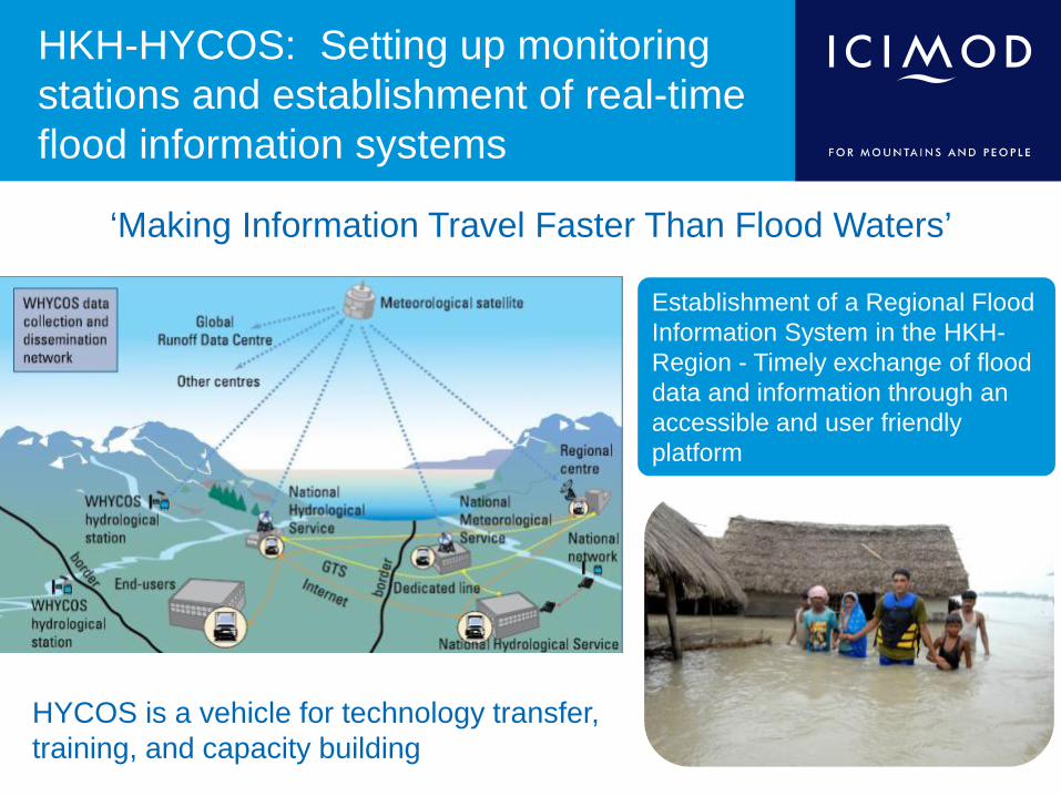
HKH-HYCOS: Setting up monitoring stations and establishment of real-time flood information systems
‘Making Information Travel Faster Than Flood Waters’
Establishment of a Regional Flood Information System in the HKH-Region - Timely exchange of flood data and information through an accessible and user friendly platform
HYCOS is a vehicle for technology transfer, training, and capacity building
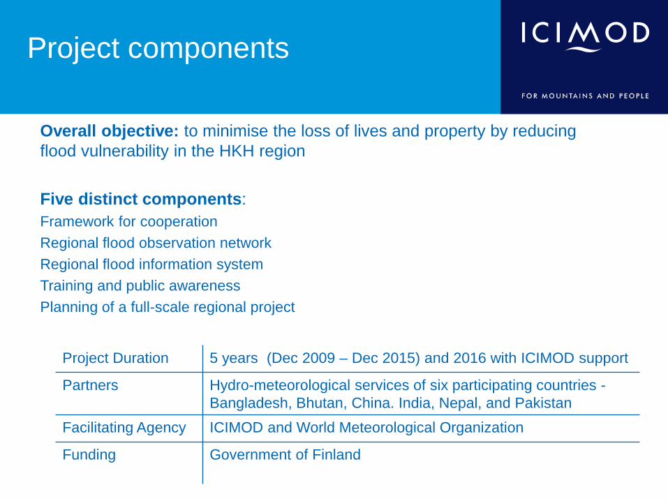
Project components
Overall objective: to minimise the loss of lives and property by reducing flood vulnerability in the HKH region Five distinct components: Framework for cooperation Regional flood observation network Regional flood information system Training and public awareness Planning of a full-scale regional project
Project Duration 5 years (Dec 2009 – Dec 2015) and 2016 with ICIMOD support
Partners Hydro-meteorological services of six participating countries -Bangladesh, Bhutan, China. India, Nepal, and Pakistan
Facilitating Agency ICIMOD and World Meteorological Organization
Funding Government of Finland

Achievements: modernization of observation network • 38 hydrometeorological stations
upgraded in four countries (Bangladesh, Bhutan, Nepal, Pakistan)
• Access to > 300 Global Telecommunication Stations of WMO
• Additional stations contributed by partners

Achievements: real-time hydrometeorological stations
• Use of latest technology for data collection
• Transmission (mobile phone using CDMA/ GSM, satellite communication)
• Establishment of regional and national flood information systems

Availability of upgraded stations and GTS stations

http://icimod.org/hycosrfis

Capacity building and public awareness • Mekong Exposure visit
• 1 Regional training is installation, operation and maintenance of equipment
• 1 Regional training in Database management
• 2 Regional training on flood outlook
• 4 National level trainings held in Bhutan , Pakistan, Nepal and Bangladesh
• Local trainings during installation held during each station upgrade
• Training materials and Standard Operating Procedures (SOP) developed for the hydrometeorological equipment

Achievements Regional flood information system Regional flood outlook
Objective: • To develop a flood outlook system
for the Ganges- Brahmaputra basin utilizing freely available data and weather forecasts
The outlook which, in essence, is a regional flood forecast based on a mathematical model describing the precipitation-runoff process in the catchments and hydrodynamic flood routing along the river system.
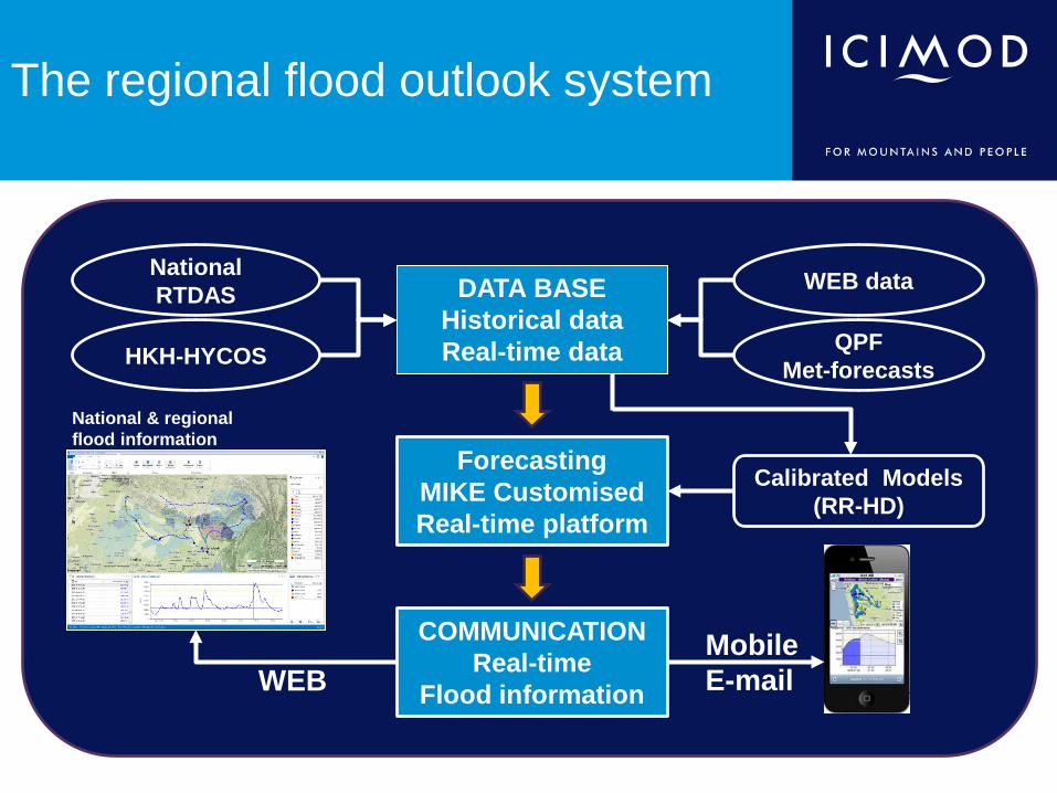
The regional flood outlook system
COMMUNICATION Real-time
Flood information
Forecasting MIKE Customised Real-time platform
DATA BASE Historical data Real-time data
WEB data
QPF Met-forecasts
Calibrated Models (RR-HD)
Mobile E-mail WEB
HKH-HYCOS
National RTDAS
National & regional flood information portals

Conceptual 1D model
Dynamic data
Observed data
Data Process
Setup of model
Static data
Model Calibration and validation of Hydrological & Hydrodynamic model
Satellite data
Topographic Data • Elevation/ DEM • Catchment delineation • River network • River cross section • Structures/controls • Model parameters
Meteorological forcing data
Real time observed/ satellite data
QPF Meteo-Forecast
Forecasting in Real time Platform
Dissemination Flood Information
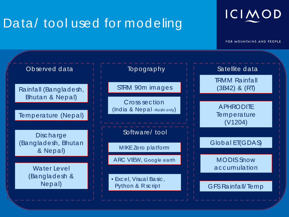
Data/ tool used for modeling
STRM 90m images
Topography
Rainfall (Bangladesh, Bhutan & Nepal)
Observed data
ARC VIEW, Google earth
TRMM Rainfall (3B42) & (RT)
Satellite data
Software/ tool
MODIS Snow accumulation
Cross section (India & Nepal –Koshi only)
Temperature (Nepal)
Discharge (Bangladesh, Bhutan
& Nepal)
APHRODITE Temperature
(V1204)
Global ET(GDAS)
• Excel, Visual Basic, Python & R script GFS Rainfall/Temp
MIKE Zero platform
Water Level (Bangladesh &
Nepal)

Pilot basins: river network & catchment delineation
Basin Ganges Brahmaputra Total Rivers 31 15 46 Catchments 53 33 86
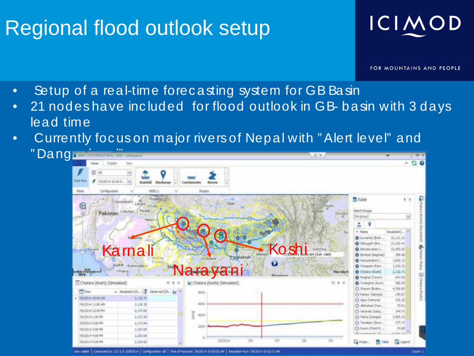
• Setup of a real-time forecasting system for GB Basin • 21 nodes have included for flood outlook in GB- basin with 3 days
lead time • Currently focus on major rivers of Nepal with ”Alert level” and
”Danger level”
Regional flood outlook setup
Karnali Narayani
Koshi

Preparation of rainfall data Merge observed data and TRMM(3b42) data
Spatial Resolution : 0.25 degree Temporal Resolution : Daily Source : NASA

Bias correction Satellite data
Linear regression in each cell point, Between monthly values in years 2000 – 2013
Slope = 0.74 R2 = 0.8

Calibration of rainfall-runoff (NAM) model

Simulation comparison - Bahadurabad
TRMM 3b42 (RT) TRMM 3b42 TRMM 3b42 bias Observed Discharge

System of flow forecast
Hindcast (Observed RT data, TRMM (RT), NASA
Quantitative Precipitation Forecast (GFS, NOAA)
~25km
Hindcast Forecast
Time of Forecast
25km +
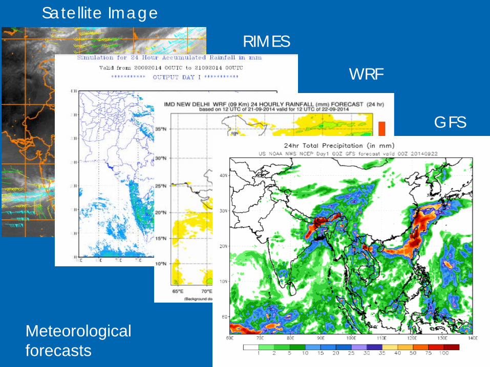
Satellite Image
RIMES
WRF
GFS
Meteorological forecasts

Testing G-B flood outlook in 2014
14 Aug 15 Aug 16 Aug
GFS rainfall forecast on 12th Aug 2014 07:00
Pilot regional flood outlook Danger Level Alert Level Monthly average Level
Legend
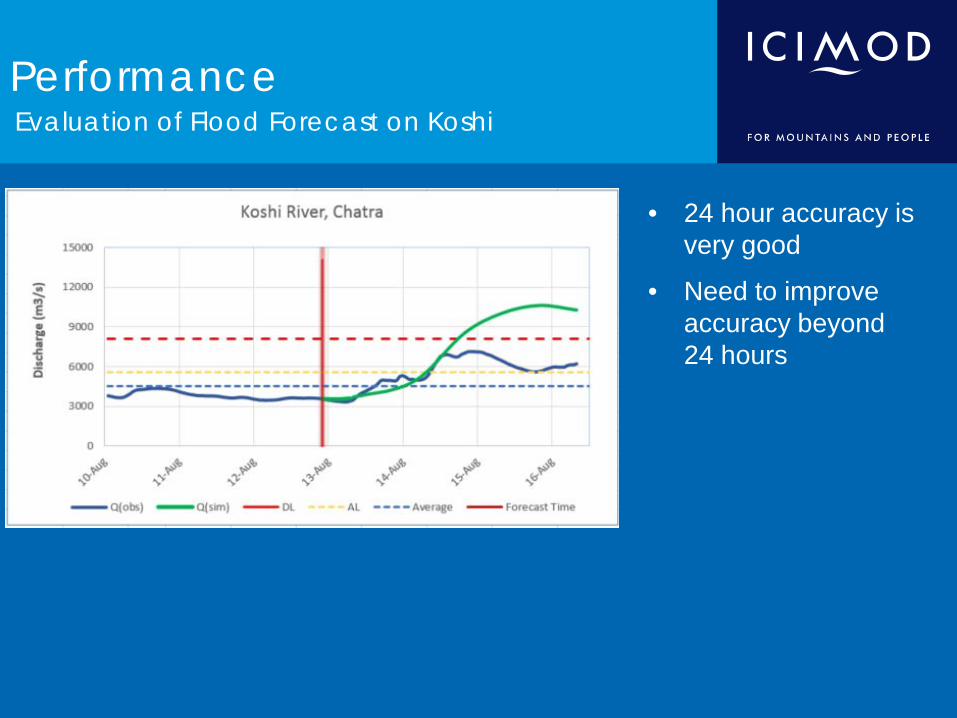
Performance Evaluation of Flood Forecast on Koshi
• 24 hour accuracy is very good
• Need to improve accuracy beyond 24 hours

Dissemination of information Web-based charts and tables

Challenges and opportunities
• Station operation and maintenance – Spare parts – Vandalism in some stations – Sim card recharge
• Database management – Quality control – Harmonization of data
• Limited capacity and human resources • Technical infrastructure and capacity for forecasting and early warning
highly variable in the region • Better integration of science-based climate information and prediction
into planning, policy and practices, especially through improved end-user interfaces.

Lessons learnt
• Latest development in the technology has enabled us to develop flood information system at basin scale
• Limited networks in the region – need further strengthening and sharing • Utility of data and information for developing flood outlook demonstrated
the value of real-time data • Capacity building and training enhanced cooperation and partnerships • Flood forecasting and warning needs to be integrated with the disaster risk
management activities for an effective end to end flood early warning system • Efforts need to be made for risk communication, awareness and better
preparedness • Institutional mechanisms for provision of flood warning to communities
need to be strengthened • Regional cooperation is a long term process which requires building trust
and confidence between and amongst countries
Opportunities for cooperation
• To better understand and analyse extreme events
• To utilize data and information for flood outlook generation and SAsiaFFG system
• To strengthen institutional capacities and build capacity through trainings
• To strengthen mutual learning, knowledge sharing and dissemination through regional platforms for enhanced disaster resilience
• To promote cooperation and collaboration in data sharing for timely warning and promote partnerships and international collaboration in disaster risk reduction.

Role of ICIMOD in SAsiaFFG System
• ICIMOD could participate at a technical level by being a part of the validation of the satellite based rainfall estimates. At the moment the flash flood guidance system is ingesting NOAA/NESDIS NOAA/CPC CMORPH) global hydroestimator product. ICIMOD could validate these products for the accuracy and also explore bias correction for improved flash flood detection.
• ICIMOD could hold regional trainings and workshops for the representatives of the national hydrometeorological services.
• ICIMOD would like to be a part of the trainings (online courses on the flash flood guidance system as well as at the HRC training programs)
• ICIMOD could work with the regional and international partners to forge cooperation in the region and provide a regional platform.

Thank you