highway 36 & manning avenue (csah 15) interchange …
TRANSCRIPT

HIGHWAY 36 & MANNING AVENUE (CSAH 15) INTERCHANGE PROJECT
P U B L I C O P E N H O U S E
WELCOMEMARCH 19, 2020
T H E B I R T H P L A C E O F M I N N E S O T A

H I G H WAY 36 & M A N N I N G AV E N U E ( C S A H 15) I N T E R C H A N G E P R O J E C T
HIGHWAY 36 CORRIDORHighway 36 is a vital principal arterial serving the north and northeast area of the Twin Cities metropolitan area. Commuter, freight, and recreational traffic use this route as a critical link to key regional, interregional, and interstate destinations.
MINNESOTA
WISCONSIN
Ram
sey
Was
hing
ton
Lake St Croix
Lake JaneLake E
lmo
Lake Olson
0 0.7 mi
MINNESOTA
36
MINNESOTA
36
MINNESOTA
36
MINNESOTA
95
MINNESOTA
95
17COUNTY
15COUNTY
15COUNTY
5COUNTY
694
694
Stillw
ater B
lvd
Lake
Elm
o Av
e
Keat
s Ave
Hilto
n Tr
Man
ning
Ave
Gree
ley S
tO
akgr
een
Ave
Osg
ood
Ave
STILLWATER
BAYPORTOAK PARK HEIGHTS
LAKE ELMO
NORTH ST. PAUL
MAHTOMEDI
GRANT
Highway 36/I-694Existing Cloverleaf
Interchange
Highway 36/Hadley AveGrade Separated
Interchange in DesignComplete 2020
Highway 36/Keats AveReduced Conflict
Intersection Constructed 2006
Highway 36/Manning AveExisting At-Grade
Intersection Shovel Ready
Highway 36/Greenley St/ Oakgreen Ave
At-Grade Intersection with Traffic Signal Constructed 2014
Highway 36/Highway 95 Diamond Interchange
Constructed 2017
St. Croix River Crossing River Bridge
Constructed 2017
Highway 36/Hilton TrailGrade Separated Interchange
with Roundabouts Constructed 2014
Highway 36/Lake Elmo Ave
Existing At-Grade Intersection
Highway 36/Stillwater BlvdExisting Grade Separated
Diamond Interchange
Highway 36/OsgoodAt-Grade Intersection
with Traffic Signal Constructed 2014
Highway 36/NorellExisting At-Grade Intersection
with Traffic Signal

H I G H WAY 36 & M A N N I N G AV E N U E ( C S A H 15) I N T E R C H A N G E P R O J E C T
PROJECT PURPOSE & GOALSPROJECT PURPOSE & GOALS
PROJECT TIMELINE
2017 2018 2019 2020 2021
CONCEPTUAL DESIGN & TRAFFIC ANALYSIS
DESIGN PROCESS, NEPA & RIGHT OF WAY
BIDDING
CONSTRUCTION
The primary purpose of this project is to improve safety and mobility at Highway 36 & Manning Avenue
Other Goals and Objectives:• Maintain access to neighborhoods and
future development• Accommodate local road connectivity• Provide safe, non-motorized access (trails,
walks, etc.)
We are here
Open House #1Accomplished Since Open House #1:• Evaluated Alternatives• Screened Against Project Goals• Coordinated with Local
Governments
Accomplished Since Open House #2:• Identified Recommended Alternative• Completed Preliminary Design (Approved
by MnDOT)• Documented Environmental Impacts
Open House #2 Open House #3
H I G H WAY 36 & M A N N I N G AV E N U E ( C S A H 15) I N T E R C H A N G E P R O J E C T
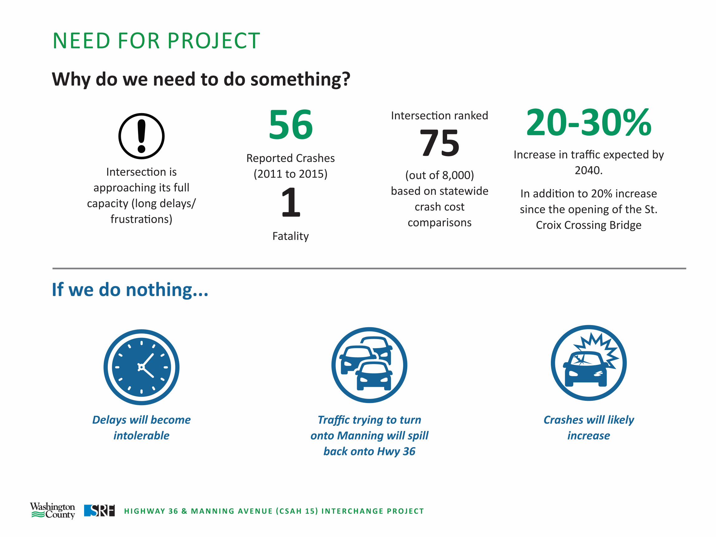
NEED FOR PROJECT Why do we need to do something?
If we do nothing...
Intersection is approaching its full
capacity (long delays/frustrations)
Delays will become intolerable
56 Reported Crashes
(2011 to 2015)
1Fatality
Traffic trying to turn onto Manning will spill
back onto Hwy 36
Intersection ranked
75 (out of 8,000)
based on statewide crash cost
comparisons
Crashes will likely increase
20-30% Increase in traffic expected by
2040.
In addition to 20% increase since the opening of the St.
Croix Crossing Bridge

H I G H WAY 36 & M A N N I N G AV E N U E ( C S A H 15) I N T E R C H A N G E P R O J E C T
DAILY TRAFFIC VOLUME – EXISTING & FORECASTED
Developer Owned
Developer Owned
MINNESOTA
36
MINNESOTA
36MINNESOTA
36
17COUNTY
15COUNTY
15COUNTY
5COUNTY
LEGEND
Interchange Concept
Full Access Intersection
Potential Local Road
Future Extension
Closed Access/Roadway Realignment
Direction of Traffic
Pedestrian Trail
x x xx x x
N
Lake
Elm
o Av
e
17,00020,000
25%Increase
NoIncrease
500500
41,00051,000
42,00049,000
33,000
14,500
63,00058,000
15%Increase
20%Increase
STILLWATER
STILLWATER TWP
OAK PARK HEIGHTS
LAKE ELMO
GRANT STILLWATER
STILLWATER TWP
OAK PARK HEIGHTS
LAKE ELMO
GRANT
Lake
Elm
o Av
e Man
ning
Ave
Stillw
ater
Blvd
Lake
Elm
o Av
e Man
ning
Ave
Stillw
ater
Blvd
x,xxx Existing 2018
x,xxx Potential 2040 with full development
Legend
Future 2040NOTE: Future traffic volumes do not account for potential development areas shown.
x,xxx
Traffic Distribution
14% 16%
69% 1%
MINNESOTA
36MINNESOTA
36
15COUNTY
Man
ning
Ave
Man
ning
Ave

H I G H WAY 36 & M A N N I N G AV E N U E ( C S A H 15) I N T E R C H A N G E P R O J E C T
CONCEPT VISUALIZATION
Interchange Concept: Not for Construction - Looking North East
Bridge Detail Concept: Not for Construction - Looking North WestExisting View: Looking North East

H I G H WAY 36 & M A N N I N G AV E N U E ( C S A H 15) I N T E R C H A N G E P R O J E C T
ENVIRONMENTAL DOCUMENTATION:
Environmental Review Summary• The project includes federal-aid highway funding; therefore, an environmental review under
the National Environmental Policy Act (NEPA) has been completed.
• The NEPA document provides information about the purpose and need; alternatives evaluation and identification of a preferred alternative; environmental impacts; and proposed mitigation measures.
• Potential impacts of the project studied in the environmental review include:
Traffic Noise• Field measurements were collected in
fall 2018.
• Modeled noise levels at most all locations in the project area are below Federal noise abatement criteria.
• A noise wall along the trail on the east side of Manning Avenue does not meet MnDOT’s reasonableness criteria and is not desired for current and future land uses.
Wetlands• Wetlands delineated in spring 2019.
• It is not possible to avoid all wetland impacts with the project.
• Features have been incorporated into the project design to minimize wetland impacts (e.g., retaining walls).
• Mitigation for wetland impacts will be acquired prior to construction.
Water Resources• The project will increase impervious
surface area compared to existing conditions.
• Existing drainage patterns will be maintained to the extent practicable.
• Stormwater basins will be constructed to treat and control runoff.
• Project includes construction of a water re-use system to irrigate Applewood Hills Golf Course.

H I G H WAY 36 & M A N N I N G AV E N U E ( C S A H 15) I N T E R C H A N G E P R O J E C T
TRAFFIC NOISE ANALYSIS
HIGHWAY 36 & MANNING AVENUE (CSAH 15) INTERCHANGE STUDY
TRAFFIC NOISE ANALYSIS
FIELD MEASUREMENTS- Document existing noise levels at
representative sites- Validate noise models (measured
levels +/- 3 dBA of model levels)
NOISE LEVEL MODELING- Develop noise models of project area roadways
and topology- Model noise levels at receptor sites (homes,
businesses, parks, etc.)- Model existing, future no-build and future build
conditions (Use 20-year traffic projections)
NOISE MITIGATION MODELING (FEASIBILITY AND REASONABLENESS)
Defined in MnDOT Noise RequirementsFeasibility- Acoustic feasibility (5 dBA reduction to be considered benefited)- Site ConstraintsReasonableness- Noise reduction design goal (reduction of at least 7 dBA at
minimum of one benefited receptor)- Cost effectiveness ($78,500 per benefited receptor)- Noise wall voting (viewpoints of benefited residents and
property owners)
- Noise levels approaching or exceeding FHWA noise abatement criteria
- 66 dBA (Leq for residential use)- Substantial noise increase (5 dBA or
more increase between future build noise levels)
NOISE ANALYSIS IS COMPLETE
IMPACTS IDENTIFIED?
YESNO
NOISE ANALYSIS IS COMPLETE
FEASIBLE AND REASONABLE NOISE WALLS ARE PROPOSED
FOR CONSTRUCTION
MEETS FEASIBILITY AND REASONABLENESS ?
YESNO
Source: Minnesota Pollution Control Agency
Decibel level of common noise sources
Field Measurement
Source: Minnesota Pollution Control Agency

H I G H WAY 36 & M A N N I N G AV E N U E ( C S A H 15) I N T E R C H A N G E P R O J E C T
NOISE ANALYSIS SUMMARY
0 800 1,600US Feet [
Legend
Approach or exceed the noise abatement criteria
Proposed Hwy 36/Manning Ave Interchange
Below the noise abatement criteria
Noise abatement criteria (NAC): upper limit of highway traffic noise levels for different land uses and activities. Noise abatement measures (e.g., noise walls) must be evaluated when modeled noise levels approach or exceed NAC limits at a receptor location.
���������
36
15COUNTY
Man
ning
Ave
5COUNTY
Stillw
ater
Blvd
17COUNTY
Lake
Elm
o Av
e
OAK PARK HEIGHTS
LAKE ELMO
GRANT STILLWATER
Sanctuary Neighborhood Noise Analysis Results
Existing noise levels (Leq, dBA)
2040 No Build noise levels
(Leq, dBA)
2040 Build noise levels
(Leq, dBA)
Change in noise levels(2040 Build - Existing)
(Leq, dBA)
47.2 - 54.2 47.9 - 55.1 48.6 - 55.8 0.5 - 2.4
• Includes modeled noise levels along trail• Approaching the noise abatement criterion is 66 dBA (Leq)
Summary
• Noise levels at one residence on the south side of Hwy 36 exceeds the Federal noise abatement criterion. A noise wall at this location would not meet MnDOT’s cost effectiveness threshold to be considered reason-able.
• Noise levels in the Sanctuary neigh-borhood are below the Federal noise abatement criterion for residential uses with the Hwy 36/Manning Avenue interchange.
• A noise wall along the trail on the east side of Manning Avenue does not meet MnDOT’s reasonableness criteria and is not desired for current and future land uses.

H I G H WAY 36 & M A N N I N G AV E N U E ( C S A H 15) I N T E R C H A N G E P R O J E C T
PROJECT FUNDING
Project Websitewww.co.washington.mn.us/Manning36Interchange
$29 MILLIONCURRENT FUNDING
$2 MILLIONLOCAL GOVERNMENTS
$5 MILLIONSTATE AID (WASHINGTON COUNTY C.I.P.)
$5 MILLIONMNDOT/METROPOLITAN COUNCIL MOBILITY FUNDS
$7 MILLIONMETROPOLITAN REGIONAL SOLICITATION (FEDERAL FUNDING)
$10 MILLIONTRANSPORTATION ECONOMIC DEVELOPMENT (TED) GRANT
$32 MILLIONTOTAL PROJECT COST
$3 MILLIONFUNDING DEFICITPOTENTIAL FUNDING SOURCES:- GENERAL OBLIGATION BONDS (NOT SECURED)