haynes land and livestock company v. jacob family chalk
TRANSCRIPT

Brigham Young University Law SchoolBYU Law Digital Commons
Utah Court of Appeals Briefs
2008
Haynes Land and Livestock Company v. JacobFamily Chalk Creek : Brief of AppelleeUtah Court of Appeals
Follow this and additional works at: https://digitalcommons.law.byu.edu/byu_ca3
Part of the Law Commons
Original Brief Submitted to the Utah Court of Appeals; digitized by the Howard W. Hunter LawLibrary, J. Reuben Clark Law School, Brigham Young University, Provo, Utah; machine-generatedOCR, may contain errors.Jonathan O. Hafen, Bryan S. Johansen; Parr, Brown, Gee and Loveless; attorneys for appellees.Ray G. Martineau, Anthony R. Martineau, Brett D. Cragun, Leslie W. Slaugh; Howard, Lewis andPetersen; attorneys for appellant. Brent A. Bohman; Attorney for Gerald Boyer, Gregory Boyer, FernBoyer, J.S. Hansen and Alfred C. Blonquist.
This Brief of Appellee is brought to you for free and open access by BYU Law Digital Commons. It has been accepted for inclusion in Utah Court ofAppeals Briefs by an authorized administrator of BYU Law Digital Commons. Policies regarding these Utah briefs are available athttp://digitalcommons.law.byu.edu/utah_court_briefs/policies.html. Please contact the Repository Manager at [email protected] withquestions or feedback.
Recommended CitationBrief of Appellee, Haynes Land & Livestock v. Jacob Family Chalk Creek, No. 20080858 (Utah Court of Appeals, 2008).https://digitalcommons.law.byu.edu/byu_ca3/1229

IN THE UTAH COURT OF APPEALS
HAYNES LAND & LIVESTOCK COMPANY, a partnership, and Triple H. Ranch, LC, a limited liability company
Plaintiff-Appellants,
JACOB FAMILY CHALK CREEK, LLC, a limited liability company; et. al.,
Defendants-Appellees
BRIEF OF APPELLEES AND CROSS APPELLANTS FERN J BOYER, GERALD G. BOYER, GREGORY BOYER, L.S. HANSEN AND ALFRED C. BLONQUIST
Appeal No. 20080858
[District Court Case No. 980600244]
Appeal from the Third Judicial District Court, Summit County, State of Utah The Honorable Bruce C. Lubeck, District Court Judge
Ray G. Martineau (2105) Anthony R. Martineau (5859) Brett D. Cragun (8683) 3098 Highland Drive, Suite 450 Salt Lake City, UT 84106 Telephone: (801) 486-0200 Email: [email protected]
Leslie W. Slaugh (3752) HOWARD, LEWIS & PETERSEN
120 East 300 North Street P.O. Box 1248 Provo, UT 84603 Telephone: (801) 373-6345 Email: [email protected]
Attorneys for Haynes Land & Livestock Company and Triple H. Ranch, LC
UTAH APPELLATE COURTS
Jonathan O. Hafen (6096) Bryan S. Johansen (9912) PARR BROWN GEE & LOVELESS
185 South State Street, Suite 800 Salt Lake City, UT 84111 Telephone: (801) 532-7840 Email: [email protected]
Attorneys for Jacob Family Chalk Creek, LLC, Catherine B. Christensen, LLC and Brian Garff
Brent A. Bohman P.O. Box 120 Morgan, UT 84050
Attorney for Gerald Boyer, Gregory Boyer, Fern Boyer, J.S. Hansen and Alfred C. Blonquist
AUG 0 6 2009

IN THE UTAH COURT OF APPEALS
HAYNES LAND & LIVESTOCK COMPANY, a partnership, and Triple H. Ranch, LC, a limited liability company
Plaintiff-Appellants,
Vo.
JACOB FAMILY CHALK CREEK, LLC, a limited liability company; et. al.,
Defendants-Appellees
BRIEF OF APPELLEES AND CROSS APPELLANTS FERN J BOYER, GERALD G. BOYER, GREGORY BOYER, L.S. HANSEN AND ALFRED C. BLONQUIST
Appeal No. 20080858
[District Court Case No. 980600244]
Appeal from the Third Judicial District Court, Summit County, State of Utah The Honorable Bruce C. Lubeck, District Court Judge
Ray G. Martineau (2105) Anthony R. Martineau (5859) Brett D. Cragun (8683) 3098 Highland Drive, Suite 450 Salt Lake City, UT 84106 Telephone: (801) 486-0200 Email: [email protected]
Leslie W. Slaugh (3752) HOWARD, LEWIS & PETERSEN
120 East 300 North Street P.O. Box 1248 Provo,UT 84603 Telephone: (801) 373-6345 Email: [email protected] Attorneys for Haynes Land & Livestock Company and Triple H. Ranch, LC
Jonathan O. Hafen (6096) Bryan S. Johansen (9912) PARR BROWN GEE & LOVELESS
185 South State Street, Suite 800 Salt Lake City, UT 84111 Telephone: (801) 532-7840 Email: [email protected]
Attorneys for Jacob Family Chalk Creek, LLC, Catherine B. Christensen, LLC and Brian Garff
Brent A. Bohman P.O. Box 120 Morgan, UT 84050 Telephone: (801) 557-7087 Attorney for Gerald Boy er, Gregory Boy er, Fern Boyer, J.S. Hansen and Alfred C. Blonquist
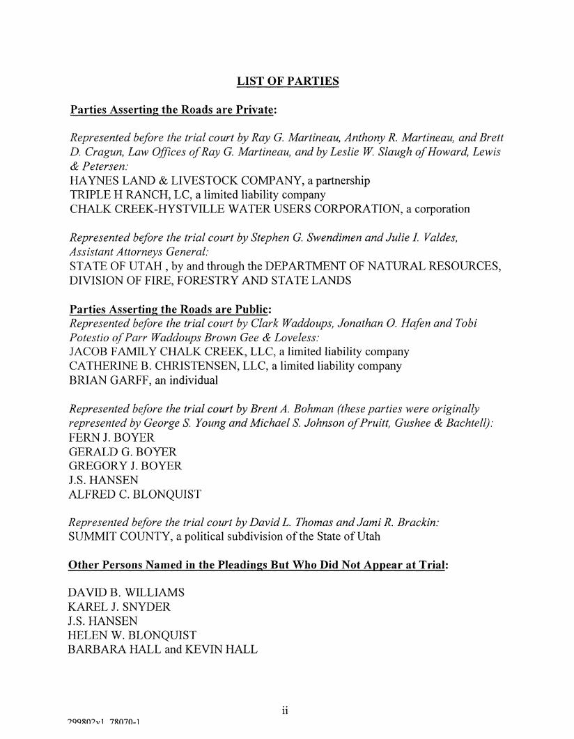
LIST OF PARTIES
Parties Asserting the Roads are Private:
Represented before the trial court by Ray G. Martineau, Anthony R. Martineau, and Brett D. Cragun, Law Offices of Ray G. Martineau, and by Leslie W. Slaugh of Howard, Lewis & Petersen: HAYNES LAND & LIVESTOCK COMPANY, a partnership TRIPLE H RANCH, LC, a limited liability company CHALK CREEK-HYSTVILLE WATER USERS CORPORATION, a corporation
Represented before the trial court by Stephen G. Swendimen and Julie I. Valdes, Assistant Attorneys General: STATE OF UTAH , by and through the DEPARTMENT OF NATURAL RESOURCES, DIVISION OF FIRE, FORESTRY AND STATE LANDS
Parties Asserting the Roads are Public: Represented before the trial court by Clark Waddoups, Jonathan O. Hafen and Tobi Potestio of Parr Waddoups Brown Gee & Loveless: JACOB FAMILY CHALK CREEK, LLC, a limited liability company CATHERINE B. CHRISTENSEN, LLC, a limited liability company BRIAN GARFF, an individual
Represented before the trial court by Brent A. Bohman (these parties were originally represented by George S. Young and Michael S. Johnson ofPruitt, Gushee & Bachtell): FERN J. BOYER GERALD G. BOYER GREGORY J. BOYER J.S. HANSEN ALFRED C. BLONQUIST
Represented before the trial court by David L. Thomas andJami R. Brackin: SUMMIT COUNTY, a political subdivision of the State of Utah
Other Persons Named in the Pleadings But Who Did Not Appear at Trial:
DAVID B. WILLIAMS KAREL J. SNYDER J.S. HANSEN HELEN W. BLONQUIST BARBARA HALL and KEVIN HALL
?OQRO?v1 78070-1 ii

TABLE OF CONTENTS
LIST OF PARTIES ii
TABLE OF AUTHORITIES v
STATEMENT OF JURISDICTION 1
STATEMENT OF ISSUES 1
STATUTORY AUTHORITIES 2
STATEMENT OF THE CASE 3
A. Nature of the Case 3
B. Course of Proceedings and Disposition Below 3
STATEMENT OF FACTS 6
1. Orientation of the Properties and the Road 6 2. Existence of the Road 8
3. Use of the Road 9
A. A Presence of Sawmills and Timbering Activity Along the Road 9
B. Grazing and Trailing of Livestock Along the Road 10
C. Homes and Farms 12
D. Reservoirs and Water Diversion 15
E. Hunting and Fishing 15
F. Socials and Dances 17
G. Federal Ownership of the Land in Dispute 17
H. Public Acknowledgments of Road Status 18
SUMMARY OF ARGUMENT 19
ARGUMENT 20
hi

TABLE OF CONTENTS (cont)
I. THE TRIAL COURT ERRED BY FAILING TO DECLARE THE MIDDLE FORK ROAD A PUBLIC ROAD ALL THE WAY TO THE BOYER PROPERTY 20
A Based On The Evidence Of Record, And The Trial Court's Own Findings, The Only Reasonable Inference Is That Members Of The Public Used The Middle Fork Road To Access The Boyer Property 21
B. The Absence Of a Map Depicting The Exact Path The Public Used To Cross The Last One-half Mile to the Boyer Property Does Not Preclude The Finding of a Public Road 22
II. THE TRIAL COURT ERRED BY NOT DECLARING THE EAST FORK ROAD A PUBLIC ROAD ALL THE WAY TO THE BOYER PROPERTY 24
A. Contrary To The Trial Court's Finding, Every Single Witness Who Testified Concerning The East Fork Road Testified As To The Existence Of Established Trail Or Way 24
B. The Fact That The East Fork May Not Have Been Used As Frequently Or As Heavily As The Middle Fork Road Does Not Preclude It From Being A Public Road 26
III. THE TRIAL COURT ERRED IN GRANTING THE WATER USERS A PRESCRIPTIVE EASEMENT ACROSS THE BOYER PROPERTY 29
CONCLUSION 30
ADDENDUM: Map of properties
299802vl 78070-1 iv

TABLE OF AUTHORITIES
Cases Cited:
Boyerv. Clark,326?.2d 107, 109 (Utah 1958) 27
Campbell v. Box Elder County, 962 P.2d 806, 809 (Utah App. 1998) 27
Town of Leeds v. Prisbrey, 179 P.3d 757 (Utah 2008) 1, 2
Lindsay Land & Livestock Co. v. Churnos, 285 P.646, 649 (Utah 1929) 23
Mason v. State, 656, P.2d 465, 468-470 (Utah 1982) 5
Memmott v. Anderson, 642 P.2d 750, 752 (Utah 1982) 23
Okelberry v. Wasatch County, 179 P.3d 768 (Utah 2008) 27
Valcarcev. Fitzgerald, 961 P.2d 305, 311 (Utah 1998) 2
Controlling Statutes Cited:
Utah Code Ann. § 72-5-104 2
Utah Code Ann. §72-5-108 3,5
Rule 15(b) of the Utah Rules of Civil Procedure 29
v

STATEMENT OF JURISDICTION
The Order and Final Judgment was entered September 16, 2008. The Notice of
Appeal was timely filed on October, 14, 2008. The Jacobs and Boyers Notice of Cross
Appeal was timely filed October 17, 2008.
The Order and Final Judgment contained a certification of finality under Rule
54(b) of the Utah Rules of Civil Procedure. A claim of partition by Triple H Ranch
against Fern Boyer, Gerald Boyer, J.S. Hansen, and Alfred C. Blonquist remains pending
before the trial court.
STATEMENT OF ISSUES
The Boyers join in Jacob's Statement of the Issues and arguments thereon and do
not separately set forth or address the same herein. This Brief of Appellee and Cross
Appellant is limited to the issues raised by way of Boyers' Cross Appeal, which are as
follows:
1. Did the trial court error in not declaring the Middle Fork Road a public all the
way to the Boyer Property?
Standard of Review: The appellate court reviews the decision of the lower court
for correctness and its factual findings for clear error, but grants to the trial court
significant discretion in the application of the facts to the statute. Town of Leeds v.
Prisbrey, 179 P.3d 757 (Utah 2008).
Preservation Below: In the Amended Answer and Counterclaims and Third Party
Claims, Boyer asserted the subject road, including the entire loop, was a public road. R-
TripleH 85-88.
1 299802vl 78070-1

2. Did the trial court error in not declaring the East Fork Road a public road all
the way to the Boyer Property?
Standard of Review: The appellate court reviews the decision of the lower court
for correctness and its factual findings for clear error, but grant to the trial court
significant discretion in the application of the facts to the statute. Town of Leeds v.
Prisbrey, 179 P.3d 757 (Utah 2008).
Preservation Below: In the Amended Answer and Counterclaims and Third Party
Claims, Boyer asserted the subject road, including the entire loop, was a public road. R-
Triple H 85-88.
3. Did the trial court error in granting the Water Users a prescriptive easement in
the road across the Boyer Property?
Standard of Review: Whether an easement exists is a conclusion of law. Such a
finding is highly fact dependent which accords the trial court a broad measure of
discretion when apply the correct legal standard to the facts. An appellate court,
therefore, overturns the conclusion of the trial court only if it finds it exceeded the broad
discretion granted. Valcarce v. Fitzgerald, 961 P.2d 305, 311 (Utah 1998).
Preservation Below: Boyers objected to the trial court granting the Water Users a
prescriptive easement in their Memorandum in Support of Motion for Reconsideration, or
in the Alternative, For Clarification. R-Haynes 1616.
STATUTORY AUTHORITIES
Utah Code Ann. §72-5-104:
^ n n o m , , ! 7 0 A 7 H 1 2

(1) A highway is dedicated and abandoned to the use of the public when it has been continuously used as a public thoroughfare for a period of ten years. (2) The dedication and abandonment creates a right-of-way held by the state in accordance with Sections 72-3-102, 72-3-104, 72-5-1-5, and 72-5-103. (3) The scope of the right-of-way is that which is reasonable and necessary to ensure safe travel according to the facts and circumstances.
Utah Code Ann. §72-5-108:
The width of rights-of-way for public highways shall be set as the highway authorities of the state, counties, or municipalities may determine for the highways under the respective jurisdiction.
STATEMENT OF THE CASE
A. Nature of the Case. This is a consolidated civil case wherein all of the parties are
seeking a determination as to whether the road at issue is a public road by virtue of R.S.
2477 and/or Utah Code § 72-5-104(l)(2006), or in the alternative, whether any easements
exist.
B. Course of Proceedings and Disposition Below. More than 100 years ago, Gerald
Boyer, Gregory Boyer, Fern Boyer, J.S. Hansen and Alfred C. Blonquist (the "Boyers")
predecessors in interest purchased a parcel of land (the "Boyer Property") for the purpose
of constructing an irrigation reservoir and, until the current dispute arose, have had
uninterrupted access to their land. Trial Transcript, Vol. II, 352, 367. In 2000, the
principles of Haynes Land and Livestock Company ("Haynes") created Triple H Ranch,
L.C. ("Triple H Ranch55) for the purpose of acquiring a one-third undivided interest in the
Boyer Property. After acquiring that interest, Triple H Ranch filed this lawsuit against
the Boyers alleging that the Boyers have no legal right of ingress or egress to their
299802vl 78070-1 3

property and, therefore, the Boyer property should he partitioned by sale. R-Triple H 1-6.
Ultimately, Haynes has admitted it is their intent to eliminate the Boyers as a landowners
in the East Fork of Chalk Creek and to acquire their property interests. Trial Transcript,
Vol III, 739. In response, the Boyers asserted that the road was a public road, or in the
alternative, they had a prescriptive right to use the road. R-Triple H, 85-89.
Prior to the initiation of this lawsuit, Haynes took issue with other landowners,
Jacob Family Chalk Creek, LLC and Catherine B. Christensen, LLC (referred to herein
together as "Jacob"), who were constructing a fourth cabin on their 10,000 acre ranch. In
an effort to control the Jacob's use of their property, in 1998 Haynes sued the Jacobs
asserting that they only had a right of ingress and egress for agricultural purposes. R-
Haynes, 1-8. In response, the Jacobs also asserted the road at issue is a public highway.
R-Haynes, 65-79.
Because of the common issues in both lawsuits; namely, whether the subject road
is a public highway, by stipulation of the parties the two actions were consolidated. R-
Triple H, 116-119. By further stipulation of the parties, Haynes' claim against the
Boyers for partition by sale was bifurcated from the underlying road dispute and reserved
for a later determination.
During the trial of the road issues, Boyers, Jacobs and Summit County introduced
evidence showing that between 1865 and 1947 the subject road was used by many
members of the public for a variety of different purposes, including accessing the area
known as The Blue Lakes which includes the Boyer Property on which Boyer Lake is
located. Trial Transcript, Vols. I - IV , 1-892. In the Memorandum Decision, the trial
4 299802vl 78070-1

court found that there was overwhelming evidence the Bench Road and the Middle Fork
Road to a point just shy of the Boyer Property had been used continuously by many
members of the public from 1865 until 1941, and declared that portion of the road to be a
public road. R-Haynes, 1393-1475. Although that determination was based in part on
the trial court's finding that many people used the public portion of the road to access
The Blue Lakes, it nevertheless failed to connect the road to the Boyer Property. R-
Haynes 1393-1475. Likewise, the trial court found the East Fork Road was a public road
only to the middle of section 8 of Township 2 North Range 8 East and, therefore, did not
connect the public portion of that road to the Boyer Property either. R-Haynes, 1451-
1452. In other words, the trial court failed to recognize that the Boyers, who have owned
and accessed their property for over 100 years, have any independent right of their own to
get to their property.1
The trial court did, however, grant the Chalk Creek-Hoytsville Water Users
Corporation (the "Water Users") a prescriptive easement across the road on the Boyer
Property despite the fact it never asserted or introduced evidence in support of such
claim. R-Haynes, 1466.
The failure of the trial court to connect the public road to the Boyer Parcel creates a dilemma for the Boyers. Should Haynes again seek to petition Summit County to vacate the public's interest in the road, the Boyer's would not be entitled to written notice of the hearing because under Utah Code §72-3-108(2)(c) written notice is only required to be provided to "owners of property abutting the county road." Even more troubling, because Boyers are not abutting landowners to the public portion of the road, were Summit County to vacate the road they would not retain a right of way in the road because they would not be abutting landowners to the vacated public road. See, e.g., Mason v. State, 656, P.2d 465, 468-470 (Utah 1982)
299802vl 78070-1 5

Following the denial of the Boyers and other parties post trial motions, the trial
court issued its Order and Final Judgment declaring the Bench Road was public, the East
Fork Road public to the middle section 8, and the Middle Fork public to a point just short
of the Boyer Property, denying the Boyers a prescriptive easement from the public
portion of the East Fork Road to their property, granting the Water User's a prescriptive
easement over the Boyer Property and delegating to Summit County the responsibility to
determine the width of the public portions of the roads. R-Haynes, 1678-1692.
STATEMENT OF FACTS
1. Orientation of the Properties and the Road.
Haynes owns approximately 9,574 acres of real property along or close to the East
Fork of Chalk Creek in Summit County. R-Haynes 2, <J| 6 (referencing Exhibit A) (the
"Haynes Property"). Jacob also owns approximately 9,346 acres of real property along
or close to the East Fork of Chalk Creek in Summit County. R-Haynes 2. 6 (referencing
Exhibit B) (the "Jacob Property"). The Jacob- Property adjoins the Haynes Property both
on the south and west borders of the Haynes Property as illustrated by Trial Exhibit 117.
Boyers own a two-thirds undivided interest in approximately thirty seven acres of land
surrounding Boyer Lake as illustrated by Exhibit 117; Trial Ex. 116.
The Road at issue in this Lawsuit consists of a loop providing Jacob and Boyer the
sole means of access to their respective properties over the land owned by the Haynes.
This loop is represented in Trial Exhibit 117. The trial court broke down the Road into
different segments. R-Haynes 1406. The first segment of the road departs from Highway
133 ("Chalk Creek Canyon Road") and travels in a southerly direction until it reaches the
?QQRO?v1 7R070-1 6

Jacob Christensen's property (the "Bench Road"). Id., see also Trial Ex. 117. The first
quarter mile of the Bench Road crosses over land owned by the Binghams and the
remainder, over land owned by the Haynes. Id. Once it reaches the Jacobs property, it
travels in a southern and easterly direction across their property until it reaches the Boyer
property (the "Middle Fork Road"). R-Haynes 1406-1407; see also, Trial Ex. 117. There
is a fork in the Bench Road located on the Haynes property at the Northwest corner of
Section 7, Range 8, Township 2 which travels in an easterly and somewhat southerly
direction. R-Haynes 1407. Trial Ex. 117. (Segments B & D)]. The Road then turns
south over Haynes' property through Sections 15, 22, 23, 25, and portions of Section 27
of Range 8, Township 2 until it reaches the Jacob Christensen property due north of
Joyce Lake. R-Haynes 1407. Trial Ex. 117. The Road then travels the east side of
Joyce Lake on Jacob Christensen's property until it reaches the Boyer Property at the
north end of Section 34, Range 8, Township 2. Id.; Trial Exhibit 117. The Road then
crosses the Boyer Property (the "Boyer Road"), travels across the reservoir until then
travels to Jacob Christensen's property once more, completing the loop in the center of
Section 34 of Range 8, Township 2, near the southern end of the Boyer Reservoir. R-
Haynes 1407-1408.
In total, the Road is approximately twenty-four miles in length and travels through
four separate townships, with the majority of the Road traveling through Township 2
North, Range 8 East, SLM. Trial Ex. 117.
299802vl 78070-1 7

2. Existence of the Road.
According to official government documents, The Bench Road, Middle Fork
Road, and the East Fork Road (to approximately the center of Township 2, Range 8,
Section 8) portions of the Road have existed for over 100 years. Trial Ex. 108 ("Survey
Plat 1"); Trial Ex. 109 (Survey Plat 2"); Trial Ex. 111 ("Survey Plat 3"); Trial Ex. 112
("Survey Plat 4"). In 1875, the United States surveyed the lands over which the first two
miles of the Bench Road are located. Trial Ex. 101 ("Government Survey 1"). This
survey shows the road described as "road to sawmill" leaving highway 133 and extending
to the south of section 1 of township 2N Range 7 East. Trial Ex. 101, p. 36. The
remaining lands in which the Bench Road, Middle Fork Road, and the first portion of the
East Fork Road are located were surveyed in 1893. Trial Ex. 103 ("Government Survey
3"); Trial Ex. 111. The surveys show that by 1893 the entire Bench Road had been
established and the Middle Fork Road extended south all the way to Section 4 of
Township 1 North, Range 8 East. See Trial Ex. 103; 104; 105, pp. 400, 419, 425, 428-
29, 432-33, 438-40, 443;111 and 112.
By 1900, the Middle Fork Road circled around towards the northeast and extended
to the midpoint of the south line of Section 34, Township 2 North Range 8 East. Trial
Ex. 113; See also Trial Ex. 166, 168 and 169.
The last portion of the Middle Fork Road, however, no longer follows that route.
Compare Trial Ex. 113 with 174. Rather, the Middle Fork Road now takes a more direct
path from Section 4 to Boyer Reservoir. Trial Ex. 174. It is this alignment that is
reflected on the Summit County Class "D" Road map. Trial Ex. 205.
8 299802vl 78070-1

3. Use of the Road.
A. Presence of Sawmills and Timbering Activity Along the Road.
In addition to the U.S. Geological Surveys showing the physical existence of the
Road as far back as 1875, there is evidence of sawmill and timbering activity along the
first couple miles of the Bench Road as early as 1865. Specifically, in 1865 the probate
court granted the petition of L.L. Randall, Jacob Huffman (and two others) to saw timber
on Chalk Creek Canyon, and further provided that u[t]he citizens shall have the privilege
to haul logs to said mill and have them sawed ...." Trial Ex. 131. Historical records
establish that the referenced sawmill was located approximately two miles up the east
fork of Chalk Creek. Trial Ex. 137 p. 139 ("The men who first owned these mills were as
follows: L.L. Randall owning a saw mill about two miles up from Pine Cliff, in the East
Fork of Calk [sic] Creek.55); Trial Ex. 158, p. 9; Trial Ex. 101, p. 36; 108 (stating in the
1875 U.S. Geological Survey that the Road went to the sawmill). Further, a 1874 map of
the Territory of Utah (Trial Ex.163), a 1875 Mineral Map of Utah (Trial Ex.164) and a
1878 Mineral Map of Utah (Trial Ex. 165) also show the existence of a saw mill in this
vicinity. This mill was operated for many years and supplied timber to the local
communities. Trial Ex. 158, p. 9.
In addition, the record shows another sawmill, owned by Merritt Staley, was
located "way up the East Fork where the ledges are." Trial Ex. 159, p. 3. This sawmill
was in existence at least by 1886 because a newspaper reported diptheria spread through
Merritt Staley's family in 1886 while the family was living at Staley's "saw mill in the
mountains." Trial Ex. 146; Trial Ex. 147 (reporting that M.T. Staley's family lost two
9 299802vl 78070-1

children to diphtheria). It operated for at least four years as at least one record shows it
was still operating in 1890. Trial Ex. 159, pp. 2-3 (noting that a boy who was born in
1880 went to visit Mr. Staley at the sawmill when the boy was 10).
In 1893, a United States surveyor reported seeing two old sawmills located along
or close to the Road. Trial Ex. 105, p. at 431, 440. One of the sawmills was located
close to the Road in Section 20, Township 2 North, Range 8 East and the other was
located along the Road in Section 7 of the same Township. Id.; Trial Ex. 117.
Further, although these records and accounts do not reveal the total number and
duration of the mills, the 1893 field notes of the U.SS. Geological surveyor revealed that
most of the usable pine trees had already been cut down, thereby establishing the
widespread and long standing timbering activities in the area adjacent to the Road. Trial
Ex. 105, p. 447.
In addition to the larger scale timbering activities occurring at the sawmills, the
trial record also shows individual members of the public also cut down and hauled away
timber from the land adjacent to the Road. See., e.g. Trial Transcript, Vol. II, 422.
B. Grazing and Trailing of Livestock Along the Road.
Besides timbering and sawmill operations, sheep herds constituted another source
of commerce in the Chalk Creek area. According to several homestead records,
individuals settled along the Road for purposes of farming and grazing. See e.g., Trial
Ex. 120, pp. JC 1546-47; Trial Ex. 119, pp. JC 1572-73.
The Boyer Property, a good portion of the Jacob property and part of the Haynes
Property are enclaves within the boundaries of the forest where the sheep were grazed
10 299802vl 78070-1

and trailed into other forest land or parts of Wyoming. Trial Ex. 117 (showing
boundaries of forest and location of the parties' property within the forest); Trial Ex. 149,
p. 8 (noting sheep herds were "making their way up Chalk Creek and to other ranges");
Trial Ex. 157, p. 7 , in App. II, Tab 28 (noting sheep herds were moved through the
Chalk Creek area and to other ranges each Spring, with some traveling as far as 200
miles); Deposition of Lloyd ("Collard Depo."), p. 18, admitted at Trial Tr. Vol. IV, p.
874 (stating "the East Fork Road" was used to trail sheep up through adjoining property
"and over to the head of the Weber").
The number of sheep moved specifically along the East Fork of Chalk Creek can
be partially measured by information about shearing and dipping corrals in the area. The
"Clark Brothers . . . built the first shearing corral, which served thousands of sheep for
many years." Trial Ex. 137, p. at 143. In 1890, the Deseret News reported that a sheep
herder who was herding "Church sheep, and was camped near Bishop Clark's shearing
corral on Mill Fork of Chalk Creek, is lost." Trial Ex. 148, p. 494. Mill Fork of Chalk
Creek connects to the Road in Section 20, Township 2 North, Range 8 East, Trial Ex.
117, and is shown as extending into and stopping at a corral in Section 12, Township 1
North, Range 7 East. Trial Ex. 117, Point L; Trial Ex. 110.
In 1893, a United States surveyor reported that John Clark had a dipping corral
located along Segment A of the Road. Trail Ex. 117; Trial Ex. 105, p. 431. His notes
state: "John Clark has a sheep dipping correll [sic] and cabin in the N.W.1/4 of Sec. 20.
His improvements are worth about $200.00." Trial Ex. 105, p. 447. The northwest
quarter of Section 20 is the head of Mill Fork. Trial Ex. 117.
11 299802vl 78070-1

In 1895, an article in the Coalville Times reported that 40,000 sheep had been
dipped already at Clark's corral that season, and that by the end of the season they
expected to dip 100,000 sheep. Trial Ex. 150, p. 1. A year later, another article reported
that over 100,000 sheep had been dipped at Clark's corral in 1896. Trial Ex. 151, p. 1. A
third article reported Clark's dipping corral was opening for another season in July 1898.
Trial Ex. 152, p. 1. Thus, Clark's dipping corral continued operations at least through
1898.
C. Homes and Farms.
Along with these business activities, by approximately 1882 people began
building homes, corrals, ditches, and fences along or close to the Road. Trial Ex. 119,
pp. JC 1570-72; Trial Ex. 120, pp. JC 1542, 1544-46.
In 1883, William H. Staley ("W. Staley") began occupying part of Section 18,
Township 2 North, Range 8 East. Trial Ex. 117; Trial Ex. 119, pp. JC 1570-72. He built
a house, corrals, and a stable, and used the property for grazing and farming. Trial Ex.
119, pp. JC 1570-72.
W. Staley did not file his homestead entry, however, until 1895. Trial Ex. 119, pp.
JC 1559, 1562. Thus, for more than ten years he used and occupied the land without
license or permission from the federal government. A homestead patent was issued to W.
Staley in 1901 for the 160-acre parcel. Trial Ex. 119, p. JC 1576.
Leonard W. Randall ("L.W. Randall") began occupying land in Section 18 of
Township 2 North Range 8 East in 1882. Trial Ex. 117; Trial Ex. 112; Trial Ex. 120, pp.
JC 1542, 1544-46. He built a house, corrals, ditches, and fences, and used the property
12 299802vl 78070-1

for grazing and farming. Trial Ex. 120, pp. 1542, 1544-46. A survey plat map also noted
the location of an irrigated field in the area. Trial Ex. 117; Trial Ex. 112 (showing the
location of the irrigated field related to the Randall cabin; see also Trial Ex. 129 (showing
L.W. Randall ditch diverted water from Red Hole Creek as early as 1884.
In 1896, L.W. Randall first filed his homestead entry, again more than ten years
after he began to use and occupy the land without license or permission. Trial Ex. 120,
pp. JC 1537, 1540. A homestead patent was issued to L.W. Randall in 1903 for the 160-
acre parcel. Trial Ex. 120, p. JC 1558.
Between 1893 and 1896, two other individuals began occupying land in Section 8,
Township 2 North, Range 8 East, along Segment B of the Road, for purposes of
establishing a homestead. Trial Ex. 121, pp. JC 2347-48; Trial Ex. 122, pp. JC 2327-28;
Trial Ex. 117.
George Huff settled on land in Section 8, Township 2 North, Range 8 East, in
December 1893, and established his actual residence a year later. Trial Ex. 117; Trial Ex.
121, pp. JC 2337, 2347. In addition to building a home, he built a stable, corrals, and
fencing. Trial Ex. 121, pp. 2345-47. He also cleared and cultivated part of the land.
Trial Ex. 121, pp. 2345-47; see also Trial Ex. 130 (showing Geo. Huffs ditch diverted
water from the East Fork of Chalk Creek as early as 1893).
Similar to W. Staley and L.W. Randall, Huff did not immediately file his
homestead entry, but waited two years, filing in December 1895. Trial Ex. 121, p. JC
2337. A homestead patent was issued to Huff in 1901 for the 160-acre parcel. Trial Ex.
121, p. 2351.
13 299802vl 78070-1

In 1896, Charles Saxton also filed his homestead entry in Section 8, Township 2
North, Range 8 East. Trial Ex., 122, p. JC 2314; Trial Ex. 117. He built a house,
corrals, fencing, and ditches. Trial Ex. 122, pp. JC 2325-27. He cultivated some of the
land, and indicated it was good for grazing. Trial Ex. 122, pp. JC 2325-27. A homestead
patent was issued to Saxton in 1903 for the 160-acre parcel. Trial Ex. 122, p. JC 2333.
Survey Plat 4, which was done in 1893, reflects further use of the Road by noting
that another corral was located in Section 10, Township 2 North, Range 8 East, about one
mile from the Huff and Saxton homesteads. Trial Ex. 112; Trial Ex. 117.
A fifth cabin was located in Section 20, Township 2 North, Range 8 East, close to
the Road. Trial Ex. 112; Trial Ex. 117. This is the same section in which Clark's
dipping corral and an old sawmill were located, which section remained in federal
ownership until 1899. Trial Ex. 112. No documents show grant of title, license, or
permission by the federal government for any person or entity to build or use a cabin,
dipping corral, or sawmill on the property either before or during the relevant time period
of 1880 to 1896. Trial Ex. 107 (hereinafter "BLM Conveyances 1") (detailing when each
portion of Section 20 was conveyed by the United States).
According to Government Survey 4, the Middle Fork Road ended in Section 4,
Township 1 North, Range 8 East, about 23 chains south of the section's north border.
Trial Ex. 117; Trial Ex. 105, p. 221 (discussing cabin that was visible in an adjoining
township. No documents show grant of title, license, or permission by the federal
government for any person or entity to build and use the cabin on the property either
299802vl 78070-1 14

before or during the relevant time period of 1880 to 1896. See Trial Ex. 106 (detailing
when each portion of Section 4 was conveyed by the United States.
D. Reservoirs and Water Diversion
By 1902, growth in the area was sufficient that farmers in Upton were
contemplating building at least three reservoirs at the head of the East Fork because there
were some lakes there and places to build a reservoir. See Trial Ex. 155.
In January 1903, a Notice of Appropriation of Water was filed by William Boyer
and others for the dual purpose of establishing a reservoir in Section 34, Township 2
North, Range 8 East, and diverting the water to Upton and Coalville. Trial 123. The
water was needed in Upton and Coalville for "irrigation purposes, domestic] purposes,
and other useful purposes." Trial Ex. 123.
E. Hunting and Fishing
The Road also provided access for recreational activities in and around the East
Fork of Chalk Creek, such as hunting and fishing. Trial Ex. 139, pp. 10-11 (discussing
hunting and fishing throughout the Chalk Creek area); Trial Transcript Vol. II, 428; 10-
22; - Fern Testimony (testifying her Uncle Sam Banner used to hunt around Red Hole
and fish around Blue Lake). "Early accounts by pioneers, stockman and explorers make
clear that bear roamed the forested land of Utah." Trial Ex. 143, p. 249. In 1899, the
Coalville Times reported that people were hunting and killing bear in the vicinity of uEast
Fork Creek.55 Trial Ex. 154, p. 1; see also Trial Ex. 153, p. 1 (reporting Clarks found bear
tracks near the "dipper,55 and the Staleys killed bear near East Fork canyon). Indeed, Red
Hole, "was a natural haunt for bear and a very popular hunting ground.55 Trial Ex. 139, p.
15 299802vl 78070-1

26; Trial Ex. 117 (showing location of Red Hole); see also Trial Transcript Vol. II., pp
425-428).
Another witness, Gwennola Blonquist, born in 1912, testified she went to the Blue
Lakes using the Middle Fork Road twice in 1933 with her husband and several other
"yahoos" to hike and recreate. Gwennola Blonquist Depo., pp. 10:24-11:8, admitted at
Trial Tr. Vol. Ill, p. 556; see also, Trial Ex. 262 (a photograph of Ms. Blonquist and a
friend in boats on the Boyer Reservoir).
During the trial, C. Kay Crittenden, born 1923, testified that he had gone up to the
Blue Lakes and fished and camped on numerous occasions prior to 1935 and never saw
any gates, signs, or any other obstruction preventing the public at large from traveling
along the Road. Trial Tr. Vol. Ill, p. 502:5-504:18.
During the trial, Fern Boyer, bom in 1928, testified that her father (and others)
used to go to Blue Lake to fish "all the time." Trial Tr. Vol. II, pp. 433:14-435:9.. A
photograph taken in 1920's was admitted showing in one photograph her mother and
father holding up a string of fish and in the other her uncle Leslie and his wife doing the
same. Trial Ex. 261. In the 1930s Ms. Boyer testified she would go up to the Blue Lakes
annually for two weeks at a time with her grandparents to camp, fish and cut timber.
Trial Tr. Vol. II, pp. 422:17-424:18.
A former resident of Upton, Robert Powell, bom in 1929, testified on one occasion
that he and his cousin drove part way up the Middle Fork Road, parked and walked to the
Blue Lakes. In fact, on the way down, he testified they encountered the local fish warden
who was patrolling the area. Trial Tr. Vol III, pp. 485:22-486:20.
16 799802v1 78070-1

Lamont Staley testified that in 1939 at the age of 12 his scoutmaster took him and
his scout troop camping to the Blue Lakes for four or five days. Deposition of Lamont
Staley, p. 17:12-21, admitted at Trial Tr. Vol. Ill, p. 554.
Finally, the biography of Myrtle Rigby, a lady homesteader, states:
Sundays were especially fun and exciting at Chalk Creek Ranch in the Summer. More frequently than not there were city visitors. A bountiful lunch was prepared, favorite horses were saddled, a team harnessed — and everyone was off to Blue Lake or Bear River to fish.
Trial Ex. 160, p. 6.
F. Socials and Dances
Social events like dances also occurred in the area. "When a dance was scheduled
[in Upton during the late 1800s], the word traveled far. The men and women at the
sawmills high in the hills heard of it and even those herding sheep around and above the
sawmills" came. Trial Ex. 142, p. at 31. By 1891, an amusement hall was built in Upton.
Trial Ex. 137, p. 143; Trial Ex. 139, p. 7; Trial Tr. Vol., II, p. 435:10-17.
G. Federal Ownership of the Land in Dispute
The United States retained ownership of every even-numbered section through
which Segments A and B of the Road traverse until approximately 1896. See, e.g., Trial
Ex. 119, p. JC 1559 (stating that homestead entry for section 18 was filed December 26,
1895); Trial Ex. 120, p. JC 1537 (stating that homestead entry for section 18 was filed
February 17, 1896); Trial Ex. 121, p. JC 2338 (stating that homestead entry for section 8
was filed December 14, 1895); Trial Ex. 122, p. JC 2314 (stating that homestead entry for
section 8 was filed May 20, 1896).
299802vl 78070-1 17

Subsequently, the sections passed from federal ownership into state or private
ownership on various dates, but the United States continued to own some of the land
along the Road as late as 1909. With respect to the odd-numbered sections, the Union
Pacific Railroad (the "Railroad") filed its map of definite location on January 8, 1869
showing the location of its tracks from Omaha, Nebraska to Promontory Summit, Utah.
Trial Ex. 132, p. 516. Odd sections of land along Segments A and B of the Road
transferred to the Railroad on that date. See, e.g., id.', Trial Ex. 127; 12 Stat. 489, § 3. A
table attached hereto as Appendix UF" details when each section along Segments A and B
of the Road passed from federal ownership.
H. Public A cknowledgments of Road Status.
The importance of canyon roads, such as the Road at issue in this Lawsuit, to the
local communities they served is shown by the 1894 minutes of the probate court. These
minutes reflect that the "[pjrosecuting attorney was instructed to forbid any person or
persons from closing any of the canyon roads in Summit County that have been used as
public highways for seven years and to prosecute any person violating the instructions
herein given." Trial Ex. S.C. 243. Further, the minutes of the Summit County
Commission show that in 1913 the county expended monies for road construction on
Sage Brush Flats which constitutes part of the Bench Road. Trial Ex. S.C. 244. In 1918,
the road is set forth on the Summit County [?] and in 1975 the entirety of the road
including the loop was designated as a Class D road on Summit County's general
highway map. Trial Ex. 114.
?QORO?vl 7R070-1 18

Further, Gwennola Blonquist, born in 1912, testified that when they used the Road
to travel to the Blue Lakes they believed that the roads were public and knew of many
people that used the Road. G. Blonquist Depo., p. 12:8-11. Fern Boyer testified that the
community was shocked with Howard Haynes, Sr. blocked off access via the Road in
about 1947 given that it hadn't been closed off prior and anyone was free to travel upon
it. Trial Tr. Vol. II, pp. 440:17-445:21. Similarly, Robert Powell testified that prior to
1950, it was his belief that the community viewed it as a public road. Trial Tr. Vol. Ill, p.
498:9-499:15. C. Kay Crittenton, bom inn 1923, also testified that there were no
restrictions on access along the Road until the Late 1940s or early 1950s and the public
was free to traverse across it. Trial Tr. Vol. Ill, pp. 507:22-509:12.
SUMMARY OF ARGUMENT
The trial court erred in not extending the public portion of the Middle Fork Road
to the Boyer Property. In the Memorandum Decision the trial court found that many
members of the public used the Middle Fork Road to access The Blue Lakes. Given that
Boyer Lake is located within the Boyer Property, and is one of the three lakes making up
The Blue Lakes, the only reasonable inference is that the public used the Middle Fork
Road to access the Boyer Property. By failing to declare the Middle Fork Road a public
road all the way to the Boyer Property, it has deprived the Boyers of the rights associated
with being abutting landowners to a public road and left them without any independent
legal right of their own to access property they have owned for over one hundred years.
In addition, the trial court erred in not extending the public portion of the East
Fork Road to the Boyer Property. Every witness who testified including Howard Haynes
19 299802vl 78070-1

Jr., acknowledged that a trail or other way extended from the middle of section 8 up to
The Blue Lakes and/or the Boyer Property. The fact that this trail or way was not
depicted on the early maps does not justify finding the public's use was not continuous
when the undisputed testimony and other facts of record evidence the public could and
did use that way whenever they choose to do so.
Finally, the trial court erred in granting the Water User's a prescriptive easement
across the Boyer Property. The Water Users did not plead such a claim, and did not
introduce into evidence any testimony or records in support of such a claim.
ARGUMENT
I. THE TRIAL COURT ERRED BY FAILING TO DECLARE THE MIDDLE FORK ROAD A PUBLIC ROAD ALL THE WAY TO THE BOYER PROPERTY.
Based in part on the trial court's finding that the public used the Middle Fork Road
to access The Blue Lakes (R-Haynes, 1443, 1464), it concluded the Middle Fork Road
was public extending into Section 4 of Township 1 North, Range 8 East.2 R-Haynes,
1464. Moreover, the trial court expressly states that it is "from that approximate point
where the public gained access to the lakes." R-Haynes, 1464. Despite these findings,
In finding that the public portion of the Middle Fork Road only extended into Section 4 of Township 1 North Range 8 East, the trial court relied upon what it refers to as exhibit 134, a 1903 U.S.G.S. map. Exhibit 134, however, is a petition to vacate and none of the parties introduced into evidence a 1903 U.S.G.S. map. The Boyers did, however, introduce into evidence a 1900 U.S.G.S. map, which is exhibit 113. It is undoubtedly this 1900 map that the court is referring to as it is the only U.S.S.G. map in evidence during that early time period. Contrary to the trial court's findings and conclusions, the 1900 U.S.G.S. map shows the Middle Fork Road curving around in a northeast direction until it reaches the southline of Section 34 of Township 2 North Range 8 East, which is just one-half mile due south of the Boyer Property. See also the 1918 Summit County map, 1929 and 1931 Wasatch National Forrest maps evidencing the same. Exhibits 166, 168 and 169 respectively.
?QQRO?v1 78070-1 20

however, the trial court concluded the public portion of Middle Fork Road does not
extend to the Boyer Property for two reasons. First, the trial court states "the evidence
does not convince the court that any particular route was used to gain access to The Blue
Lakes area." R-Haynes, 1464. Second, the trial court states, "there was insufficient
evidence (if any) that the public went across the Boyer Property ...." R-Haynes, 1464-
1465.
A. Based On The Evidence Of Record, And The Trial Court's Own Findings, The Only Reasonable Inference Is That Members Of The Public Used The Middle Fork Road To Access The Boyer Property.
During the pertinent time period, The Blue Lakes consisted of three natural bodies
of water, one of which was Boyer Lake. See Exhibits 117 and 166. These lakes are
located in a basin at the top of the East Fork of Chalk Creek Canyon into which the trial
court found the public portion of the Middle Fork Road extended. Exhibit 117, R-
Haynes, 1464. Until Boyer Reservoir was constructed in the 1930's, Boyer Lake was
located entirely within and encompassed by the Boyer Property. See Exhibits 116 and
117. Thus, access to Boyer Lake could only be accomplished by crossing over the Boyer
Property. Furthermore, Joyce Lake is located directly north of and next to Boyer Lake.
See Exhibits 117, 173 and 174. Thus, from where the 1903 U.S.G.S. map shows the
Middle Fork road extending, the most direct route to access Joyce Lake would have been
to cut across the Boyer Property.
Given the trial court's finding that many people used the Middle Fork Road to
gain access to The Blue Lakes, given that Boyer Lake is one of three lakes constituting
the area known as The Blue Lakes, given that access to Boyer Lake could not be
21 299802vl 78070-1

accomplished without crossing the Boyer Property, and given that the most direct route to
Joyce Lake from the Middle Fork is across the Boyer Property, the only reasonable
inference that can be draw from the facts of record is that the public used the Middle Fork
Road to access the Boyer Property. The trial court's finding to the contrary, therefore, is
clearly erroneous.
B. The Absence Of a Map Depicting The Exact Path The Public Used To Cross The Last One-half Mile to the Boyer Property Does Not Preclude The Finding of a Public Road.
The second basis on which the trial court concluded the Middle Fork Road is not a
public road was the lack of any evidence as to the exact path the last one-half mile of the
road traveled. R-Haynes, 1464. Although Boyer concedes that the record below does not
show any specific course or route used by the public over this short one-half mile stretch,
contrary to the conclusion of the trial court this lack of evidence is not fatal to their claim.
By way of this action, Boyers are seeking a right of ingress to and egress from
property they have owned for over 100 years - not some undefined right to travel across
Haynes' property as they please. As discussed in Part LA. above, the 1900 U.S.G.S. map
and other evidence introduced at trial was for the purpose of showing that the Middle
Fork Road was being used by the public to access The Blue Lakes, including the Boyer
Property on which Boyer Lake is located. The Boyer were not seeking during the trial to
have the trial court impose a road across the Haynes from the end of the road as depicted
on the 1903 U.S.G.S. map over to the Boyer property. The simple fact is that the portion
of the road depicted in the 1900 U.S.G.S. Map from its southernmost point in Section 4 to
the midpoint of the south section line of Section 34 no longer exists. See Exhibit 174.
22 299802v1 78070-1

As evidenced by the 1998 United States Department of Agriculture, Slader Basin
Quadrangle Map, the Middle Fork Road currently traverses on a more direct course to
and across the Boyer Parcel from section 4 of Township 1 North Range 8 East and no
longer curves around into Section 3 thereof. See Exhibit 174. In other words, the last
segment of the Middle Fork Road has been relocated.
There is no evidence that Summit County, or for that matter, the Jacobs, have ever
objected to or complained about the relocation. In fact, like the Boyers, it is the current
alignment of the road that both the Jacobs and Summit County contended during the trial
of this action should be declared to be a public road. See Exhibit 205.
It is well settled under Utah law that the relocation of a road that does not
substantially affect the general course of a highway does not alter its public status. See,
e.g., Memmott v. Anderson, 642 P.2d 750, 752 (Utah 1982) (wherein the Utah Supreme
Court held that the relocation of a segment of a road 1,800 feet to the north did not affect
the claimant's rights as an allotting landowner to a public road); Lindsay Land &
Livestock Co. v. Churnos, 285 P.646, 649 (Utah 1929) (wherein the Utah Supreme Court
held that deviations or alterations of a road that do not substantially alter its course do not
defeat the public status thereof).
It follows therefrom that the trial court should have declared the Middle Fork
Road a public road all the way to the Boyer Property.
299802v1 78070-1 23

II. THE TRIAL COURT ERRED BY NOT DECLARING THE EAST FORK ROAD A PUBLIC ROAD ALL THE WAY TO THE BOYER PROPERTY.
Although the trial court acknowledged "some" evidence the public used the East
Fork Road to gain access to The Blue Lakes (R-Haynes 1452), it concluded that the
evidence failed to clearly establish the East Fork Road is public from the middle of
section 8 to the Boyer Property because:
1. the evidence did not show "that a particular route was used along the East
Fork after leaving the middle of section 8" (R-Haynes, 1461); and
2. the uarea was described as a terrible passage, a rock pile, and other terms
showing it was not heavily used or as regularly used as the Bench and Middle Fork Roads
(R-Haynes, 1452)."
A. Contrary To The Trial Court's Finding, Every Single Witness Who Testified Concerning The East Fork Road Testified As To The Existence Of Established Trail Or Way.
By whatever their description, every single witness who testified regarding the
East Fork Road beyond the middle of section 8 acknowledged the existence of a trail or
other way, including the witnesses the trial court stated its finding was based upon:
Howard Haynes Jr.: After having testified that the East Fork Road ended in the
middle of section 8, on cross examination he testified as follows:
Q. If I understand your testimony correctly earlier, you testified that, at the time
your father purchased the property, the road that we call the East Fork loop that comes off the bench road in an easterly direction terminated at some point in Section 8; is that correct? A. That's correct. Q. And didn't continue any further. Is that your testimony? A. That's right.
?QQK0?v1 78070-1 24

Q. Okay. And you further testified that a road from that terminus point did not exist until when the reservoir built it in approximately 1940, correct? A. Well, I think it would be passable with horses and maybe some wagons, but it wasn't much of a road.
Trial Transcript, Vol. III., 670.
Kay Crittenden: Likewise, after testifying that the "road" ended in the middle of
section 8, he further testified as follows:
Q. You discussed that the road terminated around Section 8 and that your father
went in and constructed the road right? A. Right. Q. Was there a trail that led over the reservoir, though, where the road stopped that you considered to be a trail? A. That used to be what they call a pack trail. Q. Why is it a pack trail? Would you describe what a pack trail is? A. Well, a pack trail, Boyers would maybe have used that. I don't know which way the Boyers got up to build that first reservoir that was there. Q. Okay. A. And there was just a trail where they'd trail their horses and pack horses. Q. So you would be able to take a horse in there with packs or go from where the road ended in Section 8 over to the reservoir. A. Yes.
Trial Transcript, Vol. Ill, 523-524.
LeRoy Meadows: In his deposition, LeRoy Meadows testified that prior to 1932
his brother and two cousins traveled by horse and buggy to The Blue Lakes three
different years using the East Fork Road:
Q. What was the road like as you traveled up to the lake?
A. Well, it was just - a wagon road is all I can say. Q. Was it more of a road or a trail? A. Well, to the forks, there was a creek there, the two streams. It was a wagon road. It was a road. But from there on, why, there was very little road. Q. What did you use to travel it?
3 Initially, he testified this occurred in the early 1930's but later acknowledged it was prior to 1932. Deposition of LeRoy Meadow, 10-11; 28.
299802vl 78070-1 25

A. Well, we took a buggy. We had two old horses, one from each family that we hooked together, and hooked them on the buggy. It was a two-seated buggy. And we went from there right on up to Blue Lake.
Deposition of LeRoy Meadows, 13-14.
Fern Boyer: Ms. Boyer testified that in the 1930's, starting at a very early age,
she, her parents, her grandparents and others went to The Blue Lakes on many occasions
to camp, fish, and cut timber. Although she described the road as a "very rocky" and
stated her grandfather Sam Banner referred to it as that ccrocky pile", she also testified
they went up the East Fork Road traveling by team and wagon or in her father's model T
Ford. Trial Transcript, Vol. II, 420-434.
In light of this undisputed testimony, including that of Haynes, the fact that this
road does not appear on the 1900 U.S.G.S. map is not indicative of the absence of a trail
or way. The foregoing testimony clearly evidences that an established trail or way
existed from section 8 to The Blue Lakes, whatever the description used by the witness.
Conversely, no evidence of record exists denying the existence of such a trail or other
way. The trial court's conclusion that the evidence failed to show a particular route was
traveled, therefore, is contrary to the undisputed evidence of record and is clearly
erroneous.
B. The Fact That The East Fork May Not Have Been Used As Frequently Or As Heavily As The Middle Fork Road Does Not Preclude It From Being A Public Road.
In the Memorandum Decision, the trial court did not find that the public did not
use the East Fork Road beyond the middle of Section 8. To the contrary, the trial court
expressly acknowledged that there was evidence that people used that road to go to the
9QQR0?v1 7R070-1 26

Blue Lakes. R-Haynes, 1452. Nevertheless, the trial court stated it "does not believe that
portion [beyond section 8] of the road ever became public because of its much more
limited use." R-Haynes, 1460. By applying a quantitative rather than qualitative
analysis, however, the trial court applied the incorrect legal standard. See Okelberry v.
Wasatch County, 179 P.3d 768 (Utah 2008).
Under Utah Code §72-5-104(1), a road is deemed to have been dedicated to the
public "when it has been continuously used as a public thoroughfare for a period often
years." To constitute "continuous use," a claimant need only establish that the public
uuse[d] the road whenever they found it necessary or convenient." Campbell v. Box
Elder County, 962 P.2d 806, 809 (Utah App. 1998); see also Boyer v. Clark, 326 P.2d
107, 109 (Utah 1958) (concluding that continuous used requires use by the public "as
often as they found it convenient or necessary"). This does not mean, however, that use
had to be frequent. Specifically, the Utah Court of Appeals concluded that under Utah
law "[e]ven infrequent use can result in dedication of a road as a public thoroughfare."
Campbell, 962 P.2d at 809. To determine whether the East Fork Road is or is not a
public road, therefore, the proper inquiry is not how many people used the road but,
rather, whether the public was free to and in fact used the road whenever they had the
occasion to do so.
It is clear from the evidence that the public was free to use the East Fork Road
beyond section 8 at their convenience. Prior to 1941 when the trial court determined
Haynes commenced interrupting the public's use of the Bench Road, Kay Crittenden
(Trial Transcript, Vol. Ill, 508-509) and Fern Boyer (Trial Transcript, Vol. Ill, 499) both
27 299802vl 78070-1

testified that during that time period people were free to go wherever they wanted.
Moreover, there is no evidence whatsoever that once a person traveled to the middle of
Section 8 on what the trial court determined is a public road that there was anything to
prevent that person from continuing up the road.
It is also clear from the evidence that the public actually used the road to travel to
the Blue Lakes for in excess often years. For three years prior to 19324, LeRoy
Meadows testified in his deposition that he, his brother and two cousins traveled to The
Blue Lakes by horse and buggy across the East Fork Road. Deposition of LeRoy
Meadows, 10-11. Although Mr. Meadows, who is a member of the board of directors of
the Water User's, self-servingly claimed his father obtained permission from Elmer
Wright, during this time period the lands over which the East Fork Road traverses were
owned by Joseph Livingston and his wife. See Exhibit 1. Thus, his use of the East Fork
Road was as a member of the public.
Between 1932 and 1938, Fern Boyer testified that during the summers she, her
parents and her grandparents traveled by team and wagon and/or a Model T Ford up the
East Fork Road to camp, fish and cut timber. In addition, Exhibit 261 was introduced
through her showing her parents and her uncle Leslie and his wife holding up a string of
fish, which photographs she testified were taken in the 1920's. Trial Transcript, Vol. II,
420-436.
4 Initially, Mr. Meadows testified this occurred in the early 1930's but later acknowledged it was prior to 1932. Deposition of LeRoy Meadows, 28.
299802vl 78070-1 28

Yet another witness, LaMont Staley, who was born in 1927 testified that when he
was twelve years old his scout master took him and his boy scout troop camping at The
Blue Lakes using the East Fork Road. Deposition of LaMont Staley, 17. Although he
testified he did not remember which route they took to get to The Blue Lakes, later in his
deposition he stated they crossed a creek and went past the bungalows, thereby
establishing he went up the East Fork Road. Deposition of LaMont Staley, 29.
Based on the foregoing, it is clear not only that the public was free to use the road
at their convenience but also that the public actually did so. Such being the case, the trial
court erred in not declaring the East Fork Road public all the way to The Blue Lakes.
III. THE TRIAL COURT ERRED IN GRANTING THE WATER USERS A PRESCRIPTIVE EASEMENT ACROSS THE BOYER PROPERTY.
The Water Users were brought into this litigation as third party defendants and did
not assert any claim to a right to use the road across the Boyer Property. During the trial
no witnesses testified that the Water Users have ever used the road across the Boyer
property, let alone continuously under some claim of right. Moreover, the trial court did
not make a single factual finding addressing any use by the Water Users of the road
across Boyer property.
While Rule 15(b) of the Utah Rules of Civil Procedure provides that u[w]hen
issues not raised by the pleadings are tried by express or implied consent of the parties,
they shall be treated in all respects as if they had been raised in the pleadings", this rule
pre-supposes that the issue actually have been addressed at trial. Here, the Water Users
299802vl 78070-1 29

neither plead a prescriptive easement across the Boyer Property, nor did it present any
evidence pertaining to such a claim.
The trial court's decision, therefore, to grant the Water Users an easement sua
sponte across the Boyer Property was clearly erroneous.
CONCLUSION
The trial court's conclusion that the public portion of the Middle Fork Road does
not extend to the Boyer Property is clearly erroneous. Given the trial court's finding that
many members of the public used the Middle Fork Road to access The Blue Lakes, the
only reasonable inference that can be drawn therefrom is that the public used the road to
access the Boyer Property. This court, therefore, should declare the Middle Fork Road,
as currently aligned, a public road all the way to the Boyer Property.
In addition, the evidence clearly shows that the public was free to use the East
Fork Road whenever they choose to do so and that the public did in fact use the East Fork
Road for a period in excess often years. This court, therefore, should declare the East
Fork Road public all the way to the Boyer Property.
Finally, there is no evidence of record to support the trial court granting the Water
User's an easement across the Boyer Property. This court, therefore, should declare that
no such easement exists.
DATED this 6th day of August, 2009.
By:
Attorney for Gregory Boyer, Gerald Boyer, Fern Boyer and Eugene Hansen
299802vl 78070-1 30

CERTIFICATE OF SERVICE
-th I hereby certify that on the 6 day of August, 2009, a true and correct copy of the
foregoing BRIEF OF APPELLEES AND CROSS APPELLANTS FERN J BOYER,
GERALD G. BOYER, GREGORY BOYER, L.S. HANSEN AND ALFRED C.
BLONQUIST was served via first class U.S. mail, postage prepaid, upon:
Ray G. Martineau Anthony R. Martineau Brett D. Cragun 3098 Highland Drive, Suite 450 Salt Lake City, UT 84106
Leslie W. Slaugh HOWARD, LEWIS & PETERSEN
120 East 300 North Street P.O. Box 1248 Provo,UT 84603
Jonathan O. Hafen Parr Brown Gee & Loveless 185 S. State Street, Suite 800 Salt Lake City, Utah 84111
Jami R. Brackin David R. Brickey David L. Thomas SUMMIT COUNTY ATTORNEYS
60 North Main Street, Suite 227 P.O. Box 128 Coalville, UT 84017
Brent A. Bohman
onoom,,! 79mn.l 2

APPENDIX

Summit County COMMERCE' ruu strict COMPMCIAI. MAI (STATE
17 5 East 400 Soulh, Suite 700 '
S4ltL*ktCi»y.Uah84lll
Ption«: 801-322-2000
FAX: 801-322-2040
www.cornmeiceCTg.com
K! IOXO; ?Ji Km
OCcp,Ti»)«J00/
& JLCUSHMAN& ! S WAKEFIELD,
A H ' AN c »