have your say about danks street south precinct · the precinct is approximately 850metres walk...
TRANSCRIPT
have your say about
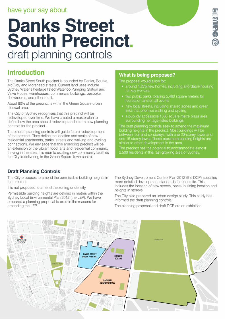
Danks Street South Precinctdraft planning controls IntroductionThe Danks Street South precinct is bounded by Danks, Bourke, McEvoy and Morehead streets. Current land uses include Sydney Water’s heritage listed Waterloo Pumping Station and Valve House, warehouses, commercial buildings, bespoke showrooms, and other retail.
About 80% of the precinct is within the Green Square urban renewal area.
The City of Sydney recognises that this precinct will be redeveloped over time. We have created a masterplan to define how the area should redevelop and inform new planning controls for the precinct.
These draft planning controls will guide future redevelopment of the precinct. They define the location and scale of new residential apartments, parks, streets and walking and cycling connections. We envisage that this emerging precinct will be an extension of the vibrant food, arts and residential community thriving in the area. It is near to exciting new community facilities the City is delivering in the Green Square town centre.
DANKS STREETSOUTH PRECINCT
GREEN SQUARETOWN CENTRE
CROWNESQUARE
LACHLANNEIGHBOURHOOD
VICTORIA PARKNEIGHBOURHOOD
GREEN SQUARESTATION
WATERLOOSTATION
Bour
ke S
treet
Botany Road
Phillip Street
Anzac Parade
Cleveland Street
Sout
h D
owlin
g St
reet
O'Dea Avenue
Lachlan Street
Mcevoy Street
Mor
ehea
d St
reet
Eliz
abet
h St
reet
Redfern Street
Joyn
ton
Aven
ue
O'Rior
dan
Stre
et
Moore Park
Redfern Park
Waterloo Park
Draft Planning ControlsThe City proposes to amend the permissible building heights in the precinct.
It is not proposed to amend the zoning or density.
Permissible building heights are defined in metres within the Sydney Local Environmental Plan 2012 (the LEP). We have prepared a planning proposal to explain the reasons for amending the LEP.
The Sydney Development Control Plan 2012 (the DCP) specifies more detailed development standards for each site. This includes the location of new streets, parks, building location and heights in storeys.
The City also prepared an urban design study. This study has informed the draft planning controls.
The planning proposal and draft DCP are on exhibition.
What is being proposed?The proposal would allow for:
• around 1,275 new homes, including affordable housing for key workers
• two public parks totalling 5,460 square meters for recreation and small events
• new local streets, including shared zones and green links that prioritise walking and cycling
• a publicly accessible 1500 square metre plaza area surrounding heritage-listed buildings.
The draft planning controls seek to amend the maximum building heights in the precinct. Most buildings will be between four and six storeys, with one 20-storey tower and one 16-storey tower. These maximum building heights are similar to other development in the area. The precinct has the potential to accommodate almost 2,500 residents in this fast-growing area of Sydney.

have your say about
Danks Street South Precinctdraft planning controls InfrastructureThe City of Sydney anticipates the Danks Street South precinct will redevelop over a significant period – possibly up to ten years. The sites have multiple owners, and many have successful businesses operating on them. The draft DCP considers the likely phasing of development and allows for individual sites to redevelop independently.
The Green Square Infrastructure Strategy and Plan identifies what infrastructure is required to be provided, including both physical (such as roads, parks, stormwater management) and social infrastructure (such as community centres, libraries, and schools). The strategy and plan also identifies the relevant agencies and timeframes for the delivery of this infrastructure. The precinct is approximately 850metres walk from the services and facilities in the Green Square Town Centre
The City recognises that traffic congestion and accessing public transport are significant issues in this area. We do not propose to increase the density of the precinct, and new streets will be provided to give access for the new residents. Shared zones are proposed, which will be designed so that people walking, riding bikes and driving will have equal access to the carriageway. The shared zones will be designed so that vehicles will have to travel at very slow speeds.
Traffic and TransportThe City engaged consulting firm, PeopleTrans to assess potential traffic and transport impacts resulting from the precinct’s redevelopment. Their report contains recommendations that will need to be implemented as development starts.
Roads and Maritime Services is currently investigating upgrading the intersection of Lachlan/Bourke and McEvoy Streets, and this will connect the WestConnex portal at Sydney Park to South Dowling Street. This is a state government project. The City does not support WestConnex or this intersection upgrade as they will most likely increase the amount of traffic in the area.
The City is aware that in the morning peak many of the buses along Bourke Street are often full. The City is in regular contact with Sydney Buses lobbying them to increase the frequency of bus services along this route. The proposed cycleways will provide alternative transport options for new and existing residents.
The City has referred the draft planning controls to relevant state government agencies and invited their feedback.
VEHICULAR ENTRIES(OPTIONAL)
SHARED ZONE(WITH DIRECTION OF TRAVEL)
DIRECTION OF TRAVEL
SIGNALISED INTERSECTION
CONSOLIDATED CAR PARK(OPTIONAL)
NO CAR PARKING
PEDESTRIAN CROSSING
CIRCULATION AND ACCESS
PUBLIC OPEN SPACEVEHICULAR ENTRIES
PEDESTRIAN / CYCLE LINK
N
NOVEMBER 2016
KEY
PRECINCT BOUNDARY
YOU
NG
STR
EET
McEVOY STREET
WAL
KER
STR
EET
POWELL STREET
BOURKE
STR
EET
HU
NTE
R S
TREE
T
MO
REH
EAD
STR
EET
YOUNG STR
EET
DUNKERLEY PLACE
ARCHIBALD AVENUE
SAM
SIN
G S
TREE
T
LACHLAN STREET
POTTER STREET
CR
YSTA
L ST
REE
T
KEN
SIN
GTO
N S
TREE
T
WELLINGTON STREET
DANKS STREET
PHILLIP STREET
KEPO
S ST
REE
T
MAR
RIO
TT S
TREE
T
BAPT
IST
STR
EET
TimeframeStep 1 Public exhibition of planning controls 2 May to 30
May 2017.
Step 2 Review submissions, make any amendments to the draft planning controls.
Step 3 Report outcomes of the public exhibition to Council and the Central Sydney Planning Committee.
Step 4 If approved by Council and the Central Sydney Planning Committee, the process to amend the LEP will commence with Parliamentary Counsel.
Step 5 Plan becomes a legal document and is used to assess development applications.
VEHICULAR ENTRIES(OPTIONAL)
SHARED ZONE(WITH DIRECTION OF TRAVEL)
DIRECTION OF TRAVEL
SIGNALISED INTERSECTION
CONSOLIDATED CAR PARK(OPTIONAL)
NO CAR PARKING
PEDESTRIAN CROSSING
CIRCULATION AND ACCESS
PUBLIC OPEN SPACEVEHICULAR ENTRIES
PEDESTRIAN / CYCLE LINK
N
NOVEMBER 2016
KEY
PRECINCT BOUNDARY
YOU
NG
STR
EET
McEVOY STREET
WAL
KER
STR
EET
POWELL STREET
BOURKE
STR
EET
HU
NTE
R S
TREE
T
MO
REH
EAD
STR
EET
YOUNG STR
EET
DUNKERLEY PLACE
ARCHIBALD AVENUE
SAM
SIN
G S
TREE
T
LACHLAN STREET
POTTER STREET
CR
YSTA
L ST
REE
T
KEN
SIN
GTO
N S
TREE
T
WELLINGTON STREET
DANKS STREET
PHILLIP STREET
KEPO
S ST
REE
T
MAR
RIO
TT S
TREE
T
BAPT
IST
STR
EET

have your say about
Danks Street South Precinctdraft planning controls HeritageWaterloo was once famous for being an industrial centre but this has been in decline since the 1950s. This industrial decline has resulted in residential and retail development. There are traces, however, of the industrial past, as seen in the traditional workers terraces of the Waterloo Conservation area, and the heritage listing of some of the former factories and warehouses.
There are four heritage listed buildings in the Danks Street South precinct. Sydney Water own two, the Pump House and Valve House, which were built in the mid 1920s. These two buildings are still operating, supplying water to the eastern suburbs. The heritage listing also includes the underground pipes associated with these two buildings.
The other two heritage listed buildings are on Young Street. One is an electricity substation at 198-222 Young Street (owned by Ausgrid and dating back to 1915), and a privately-owned industrial building at 241 Young Street that dates back to the early 1900s.
H
H
H
H
N
NOVEMBER 2016
KEY
PRECINCT BOUNDARY
YOU
NG
STR
EET
McEVOY STREET
WAL
KER
STR
EET
POWELL STREET
BOURKE
STR
EET
HU
NTE
R S
TREE
T
MO
REH
EAD
STR
EET
YOUNG STR
EET
DUNKERLEY PLACE
ARCHIBALD AVENUE
SAM
SIN
G S
TREE
T
LACHLAN STREET
POTTER STREET
CR
YSTA
L ST
REE
T
KEN
SIN
GTO
N S
TREE
T
WELLINGTON STREET
DANKS STREET
PHILLIP STREET
KEPO
S ST
REE
T
MAR
RIO
TT S
TREE
T
BAPT
IST
STR
EET
It is not proposed to list any more buildings in the precinct.
The City of Sydney proposes to create a new plaza located between the two Sydney Water heritage buildings. It will be approximately 1,500 square metres in size and located at the terminus of the central park. The plaza will be open to the public but will be owned by Sydney Water due to their infrastructure assets. Where appropriate buildings around the edges of the plaza and parks could offer outdoor dining spaces for local cafes.
The heritage listed buildings, will help to provide architectural variety and character to the precinct.
A heritage impact assessment by heritage architect Matt Devine is provided. It makes some recommendations on redevelopment of the precinct that can improve the amenity and setting of these heritage buildings. These can be incorporated into the finalised planning controls where appropriate.

have your say about
Danks Street South Precinctdraft planning controls
Urban designThe current planning controls do not allow development sites to achieve the permissible floor space ratio (FSR) within the current permissible height controls. This is because of the constraints of easements, arterial road reservation, heritage items and stormwater culverts.
The City, with SJB Planning, undertook urban design testing and an urban design study to better understand how the FSR could be accommodated across the precinct without compromising amenity.
The study defines the public domain layout and includes indicative locations and functions of new streets, open spaces, meeting places, land uses, walking and bike connections to the wider Green Square and surrounding areas.
The proposed built form will provide a variety of building heights (see image below right). This is a similar approach taken in other precincts such as Victoria Park in Zetland. New buildings will provide a noise buffer to Bourke, McEvoy and Lachlan streets, with the living and sleeping spaces facing the plaza and park areas, rather than the busy streets.
The Urban Design Study provides detail on the built form testing and a recommended built form option. A predominant building height of six storeys, with some four storey buildings is recommended with two taller buildings of 16 and 20 storeys.
Two new parks and green links will be provided. These new open spaces will provide improved amenity and passive recreation for the community.
The proposal provides:• around 1,275 new homes, including affordable housing for
key workers
• two public parks totalling 5,460 square meters for recreation and small events
• new local streets, including shared zones that prioritise walking and cycling
• a 1500 square metre publicly accessible plaza area surrounding the heritage-listed buildings.
The City has assessed the overshadowing impacts of the proposed built form, and these comply with the requirements in the NSW Government’s Apartment Design Guide and the City’s planning controls. The two towers will have small footprints to reduce impacts on overshadowing and distrct views.
A height of buildings (in metres) map is provided in the planning proposal. The draft DCP shows the location of buildings and their height in storeys.
25 STOREYS 25
STOREYS
14STOREYS
20STOREYS
16STOREYS
15STOREYS
10STOREYS
13STOREYS
17STOREYS
12STOREYS
12STOREYS
7STOREYS
have your say about
Danks Street South Precinctdraft planning controls Invitation to commentThe exhibition runs from 2 May to 30 May 2017.
Written submissions should be sent to:
John Davies, Specialist Planner
City of Sydney Council
GPO Box 1591
Sydney NSW 2001
or emailed to [email protected]
Community information sessionThe City is consulting with the community about the Danks Street South planning proposal outside Danks Street Plaza, Crystal Street, Waterloo from 4pm to 7pm on Thursday 18 May 2017.
Accessing the informationIn addition, the City will:
• send a notification letter to residents and stakeholders
• create a page on the SydneyYourSay website (www.sydneyyoursay.com.au)
• consult key stakeholders using community networks
• exhibit a 3D physical model of the planning proposal at the Tote
• exhibit hard copies at the One-Stop-Shop, Waterloo Library and Neighbourhood Service Centres (Green Square and Redfern)
• advertise the proposal in local media
The draft planning controls, and supporting material can be viewed online at sydneyyoursay.com You can also see hard copies of the exhibition material at:
� City of Sydney One Stop Shop
Level 2, 456 Kent St
Sydney
Monday to Friday: 8am – 6pm
� Green Square
The Tote building
100 Joynton Avenue
Zetland
Monday to Friday: 10am-6pm
� Redfern
158 Redfern Street
Redfern
Monday to Friday: 9-5pm
Saturday: 9am to midday
� Waterloo Library
770 Elizabeth Street
Waterloo
Monday to Thursday: 10am to 6pm
Friday: 10am to 5pm
Saturday: 11am to 4pm
All these venues are closed on Sundays and public holidays.
Need help with this information?