east werribee employment precinct precinct structure plan · 30 east werribee employment precinct...
TRANSCRIPT
30
EAST WERRIBEE EMPLOYMENT PRECINCT PRECINCT STRUCTURE PLAN
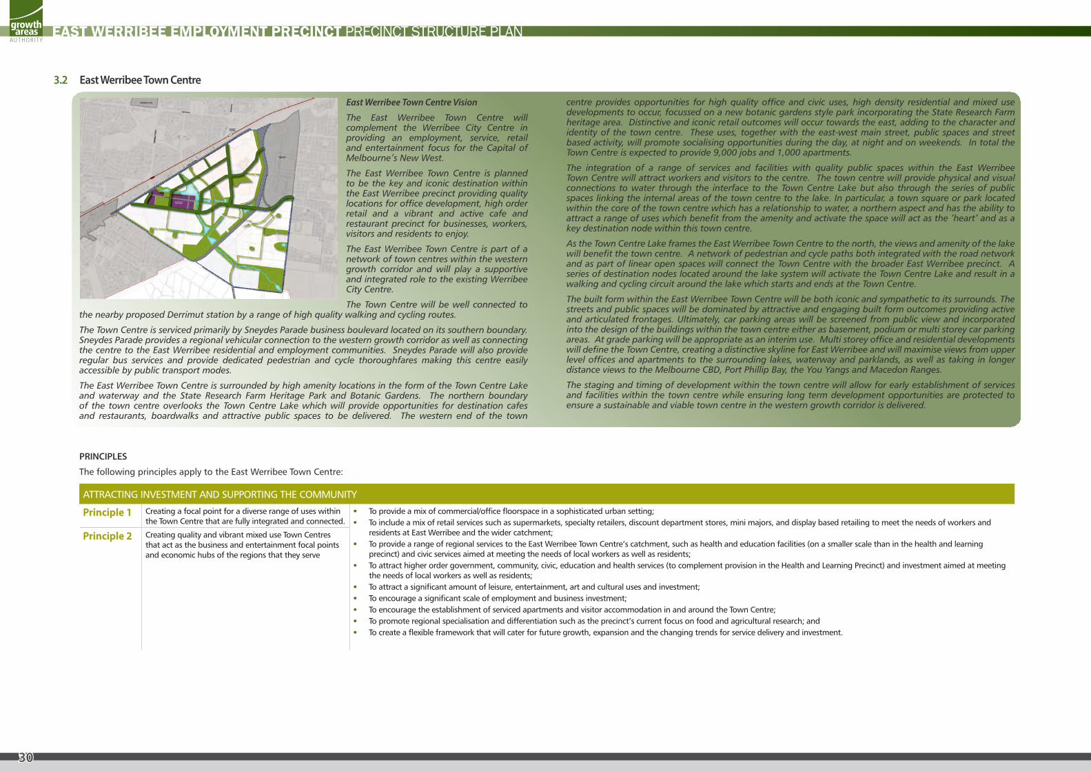
East Werribee Town Centre Vision
The East Werribee Town Centre will complement the Werribee City Centre in providing an employment, service, retail and entertainment focus for the Capital of Melbourne’s New West.
The East Werribee Town Centre is planned to be the key and iconic destination within the East Werribee precinct providing quality locations for office development, high order retail and a vibrant and active cafe and restaurant precinct for businesses, workers, visitors and residents to enjoy.
The East Werribee Town Centre is part of a network of town centres within the western growth corridor and will play a supportive and integrated role to the existing Werribee City Centre.
The Town Centre will be well connected to the nearby proposed Derrimut station by a range of high quality walking and cycling routes.
The Town Centre is serviced primarily by Sneydes Parade business boulevard located on its southern boundary. Sneydes Parade provides a regional vehicular connection to the western growth corridor as well as connecting the centre to the East Werribee residential and employment communities. Sneydes Parade will also provide regular bus services and provide dedicated pedestrian and cycle thoroughfares making this centre easily accessible by public transport modes.
The East Werribee Town Centre is surrounded by high amenity locations in the form of the Town Centre Lake and waterway and the State Research Farm Heritage Park and Botanic Gardens. The northern boundary of the town centre overlooks the Town Centre Lake which will provide opportunities for destination cafes and restaurants, boardwalks and attractive public spaces to be delivered. The western end of the town
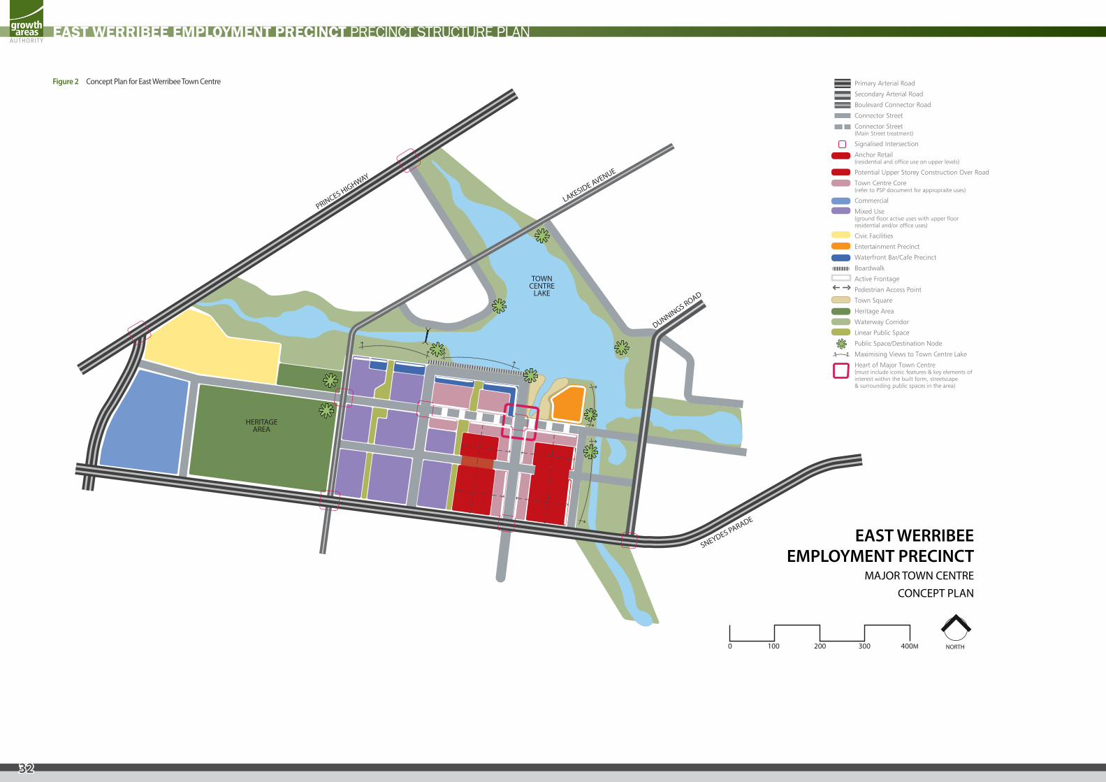
centre provides opportunities for high quality office and civic uses, high density residential and mixed use developments to occur, focussed on a new botanic gardens style park incorporating the State Research Farm heritage area. Distinctive and iconic retail outcomes will occur towards the east, adding to the character and identity of the town centre. These uses, together with the east-west main street, public spaces and street based activity, will promote socialising opportunities during the day, at night and on weekends. In total the Town Centre is expected to provide 9,000 jobs and 1,000 apartments.
The integration of a range of services and facilities with quality public spaces within the East Werribee Town Centre will attract workers and visitors to the centre. The town centre will provide physical and visual connections to water through the interface to the Town Centre Lake but also through the series of public spaces linking the internal areas of the town centre to the lake. In particular, a town square or park located within the core of the town centre which has a relationship to water, a northern aspect and has the ability to attract a range of uses which benefit from the amenity and activate the space will act as the ‘heart’ and as a key destination node within this town centre.
As the Town Centre Lake frames the East Werribee Town Centre to the north, the views and amenity of the lake will benefit the town centre. A network of pedestrian and cycle paths both integrated with the road network and as part of linear open spaces will connect the Town Centre with the broader East Werribee precinct. A series of destination nodes located around the lake system will activate the Town Centre Lake and result in a walking and cycling circuit around the lake which starts and ends at the Town Centre.
The built form within the East Werribee Town Centre will be both iconic and sympathetic to its surrounds. The streets and public spaces will be dominated by attractive and engaging built form outcomes providing active and articulated frontages. Ultimately, car parking areas will be screened from public view and incorporated into the design of the buildings within the town centre either as basement, podium or multi storey car parking areas. At grade parking will be appropriate as an interim use. Multi storey office and residential developments will define the Town Centre, creating a distinctive skyline for East Werribee and will maximise views from upper level offices and apartments to the surrounding lakes, waterway and parklands, as well as taking in longer distance views to the Melbourne CBD, Port Phillip Bay, the You Yangs and Macedon Ranges.
The staging and timing of development within the town centre will allow for early establishment of services and facilities within the town centre while ensuring long term development opportunities are protected to ensure a sustainable and viable town centre in the western growth corridor is delivered.
PRINCIPLES
The following principles apply to the East Werribee Town Centre:
ATTRACTING INVESTMENT AND SUPPORTING THE COMMUNITY
Principle 1 Creating a focal point for a diverse range of uses within the Town Centre that are fully integrated and connected.
• To provide a mix of commercial/office floorspace in a sophisticated urban setting; • To include a mix of retail services such as supermarkets, specialty retailers, discount department stores, mini majors, and display based retailing to meet the needs of workers and
residents at East Werribee and the wider catchment; • To provide a range of regional services to the East Werribee Town Centre’s catchment, such as health and education facilities (on a smaller scale than in the health and learning
precinct) and civic services aimed at meeting the needs of local workers as well as residents; • To attract higher order government, community, civic, education and health services (to complement provision in the Health and Learning Precinct) and investment aimed at meeting
the needs of local workers as well as residents; • To attract a significant amount of leisure, entertainment, art and cultural uses and investment; • To encourage a significant scale of employment and business investment; • To encourage the establishment of serviced apartments and visitor accommodation in and around the Town Centre; • To promote regional specialisation and differentiation such as the precinct’s current focus on food and agricultural research; and • To create a flexible framework that will cater for future growth, expansion and the changing trends for service delivery and investment.
Principle 2 Creating quality and vibrant mixed use Town Centres that act as the business and entertainment focal points and economic hubs of the regions that they serve
3.2 East Werribee Town Centre
31
EAST WERRIBEE EMPLOYMENT PRECINCT PRECINCT STRUCTURE PLAN
FOSTERING BUSINESS DEVELOPMENT AND EMPLOYMENT
Principle 3 Integrate employment and service opportunities in a business friendly environment.
• To provide employment opportunities to enable at least 9,000 jobs including a progressive range of office premises and office/showroom spaces; • To support and promote nearby employment and industrial areas within the region, for example by encouraging local industrial companies to locate their head office at East
Werribee; • To attract a range of small, medium and large businesses to provide employment opportunities in high quality built form locations, locations with amenity, transport options and
infrastructure and an active and vibrant Town Centre; • To foster the growth of small scale local businesses offering services and products to the local and metropolitan markets; and • To create an attractive place to conduct bus
Principle 4 Supports and promotes nearby employment and industrial areas within the region.
CONNECTING THE REGION
Principle 5 Design the Town Centre to be pedestrian friendly and accessible by all modes including public transport, while enabling private vehicle access.
• To provide the Town Centre with direct access to the arterial road network and Princes Freeway via Sneydes Road; • To locate the Town Centre on the intersection of Sneydes Road and Lakeside Avenue, and with good exposure to Dunnings and Derrimut Roads for ease of access and to maximise
exposure; • To ensure the Town Centre is well serviced by multiple transport modes and routes and promote their use; • To support the network of existing and proposed Town Centres within the region, particularly Werribee City Centre; and • To provide strong connections to, from and within the Town Centre to promote walking and cycling;
Principle 6 Creating Town Centres that are well served by multiple transport routes and are located at a major transit stop.
Principle 7 Locating Town Centres on or close to arterial/arterial intersections.
CREATING VALUED DESTINATIONS
Principle 8 Create a sense of place with high quality engaging urban design.
• To connect the various precincts of the Town Centre through a interconnected series of public spaces which are attractive environments to walk and cycle through; • To ensure all public spaces are framed by a variety of uses and are active at various times of the day and night and on weekends; • To create a high quality and engaging environment with appropriate urban scale, density and intensity; • To create well linked high quality destinations in and around the Town Centre, including the Town Centre Lake, the State Research Farm Heritage Park and Botanic Gardens and a
central public space within the Town Centre that become meeting places and the ‘heart’ of the business precincts and the community; and • To create a Town Centre that is authentic to both the local and regional communities and promotes social interaction and exchange.
Principle 9 Providing clear location and cultural identity for the catchment that the Town Centre serves.
Principle 10 Providing clear location and cultural identity for the catchment that the Town Centre serves.
Principle 11 Focus on a public space as the centre of community life.
DELIVERING HOUSING OPTIONS
Principle 12 Include a range of medium and high density housing and other forms of residential uses within and around the Town Centre.
• To provide a range of high density housing options within the Town Centre (above ground floor level) to support the services and facilities on offer; • To create a fine grain mixed use environment within the Town Centre which facilitates the establishment of commercial and residential outcomes; and • To provide options for retirement living/aged care/assisted care in close proximity and which is well connected to the services offered by the Town Centre.
RESPECTING THE ENVIRONMENT
Principle 13 Locate the Town Centre in an attractive setting which respects the natural environment and history of the area.
• To incorporate the state research farm and D1 Drain into the town centre design through the creation of the Town Centre Lake and State Research Farm Heritage Park and Botanic Gardens, and to create a high level of amenity on surrounding roads through the boulevard tree planting, all of which assist in creating a sense of place;
• To incorporate water efficiencies and WSUD principles in the town centre to ensure minimum impact to surrounding waterways; • To create a regional destination which links the natural elements with the urban fabric of the Town Centre; • To provide regional pedestrian and cycle links which link the natural environment to the Town Centre; and • To integrate views to the Town Centre Lake, State Research Farm Heritage Park, Macedon Ranges, You Yangs, Port Phillip Bay and the Melbourne CBD into the design of the Town
Centre.
PROMOTING SUSTAINABILITY AND ADAPTABILITY
Principle 14 Creating a Town Centre which promotes regional specialisation and differentiation.
• To promote the localisation and regionalisation of services into the Town Centre that will contribute to a reduction of travel distance to access local services and less dependence on the car;
• To design the Town Centre to be sympathetic to its natural surrounds through integrated water management and through appropriate landscape and construction techniques; and • To ensure the Town Centre has an inbuilt capacity for growth and change to enable adaptation and the intensification of uses as the needs of the businesses and community evolve.
Principle 15 Ensuring the Town Centre has scope for future development and expansion.
32
EAST WERRIBEE EMPLOYMENT PRECINCT PRECINCT STRUCTURE PLAN
HERITAGEAREA
SNEYDES PARADE
LAKESIDE AVENUE
DUNNINGS ROAD
PRINCES HIGHWAY
Primary Arterial Road
Secondary Arterial Road
Boulevard Connector Road
Connector Street
Connector Street(Main Street treatment)
Signalised Intersection
Anchor Retail(residential and office use on upper levels)
Potential Upper Storey Construction Over Road
Town Centre Core(refer to PSP document for appropraite uses)
Commercial
Mixed Use(ground floor active uses with upper floorresidential and/or office uses)
Civic Facilities
Entertainment Precinct
Waterfront Bar/Cafe Precinct
Boardwalk
Active Frontage
Pedestrian Access Point
Town Square
Heritage Area
Waterway Corridor
Linear Public Space
Public Space/Destination Node
Maximising Views to Town Centre Lake
Heart of Major Town Centre(must include iconic features & key elements ofinterest within the built form, streetscape& surrounding public spaces in the area)
NORTH
EAST WERRIBEEEMPLOYMENT PRECINCT
MAJOR TOWN CENTRECONCEPT PLAN
TOWN CENTRE
LAKE
0 100 200 300 400M
Figure 2 Concept Plan for East Werribee Town Centre
33
EAST WERRIBEE EMPLOYMENT PRECINCT PRECINCT STRUCTURE PLAN
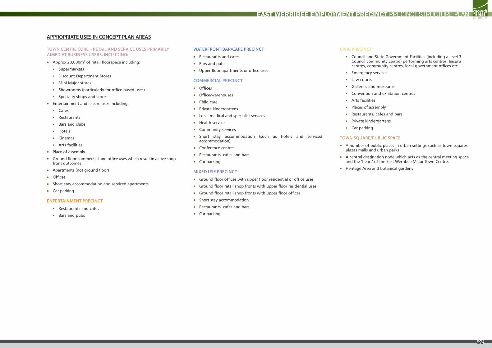
TOWN CENTRE CORE – RETAIL AND SERVICE USES PRIMARILY AIMED AT BUSINESS USERS, INCLUDING:
• Approx 20,000m2 of retail floorspace including:
• Supermarkets
• Discount Department Stores
• Mini Major stores
• Showrooms (particularly for office based uses)
• Specialty shops and stores
• Entertainment and leisure uses including:
• Cafes
• Restaurants
• Bars and clubs
• Hotels
• Cinemas
• Arts facilities
• Place of assembly
• Ground floor commercial and office uses which result in active shop front outcomes
• Apartments (not ground floor)
• Offices
• Short stay accommodation and serviced apartments
• Car parking
ENTERTAINMENT PRECINCT
• Restaurants and cafes
• Bars and pubs
WATERFRONT BAR/CAFE PRECINCT
• Restaurants and cafes
• Bars and pubs
• Upper floor apartments or office uses
COMMERCIAL PRECINCT
• Offices
• Office/warehouses
• Child care
• Private kindergartens
• Local medical and specialist services
• Health services
• Community services
• Short stay accommodation (such as hotels and serviced accommodation)
• Conference centres
• Restaurants, cafes and bars
• Car parking
MIXED USE PRECINCT
• Ground floor offices with upper floor residential or office uses
• Ground floor retail shop fronts with upper floor residential uses
• Ground floor retail shop fronts with upper floor offices
• Short stay accommodation
• Restaurants, cafes and bars
• Car parking
CIVIC PRECINCT
• Council and State Government Facilities (including a level 3 Council community centre) performing arts centres, leisure centres, community centres, local government offices etc
• Emergency services
• Law courts
• Galleries and museums
• Convention and exhibition centres
• Arts facilities
• Places of assembly
• Restaurants, cafes and bars
• Private kindergartens
• Car parking
TOWN SQUARE/PUBLIC SPACE
• A number of public places in urban settings such as town squares, plazas malls and urban parks
• A central destination node which acts as the central meeting space and the ‘heart’ of the East Werribee Major Town Centre.
• Heritage Area and botanical gardens
APPROPRIATE USES IN CONCEPT PLAN AREAS
34
EAST WERRIBEE EMPLOYMENT PRECINCT PRECINCT STRUCTURE PLAN
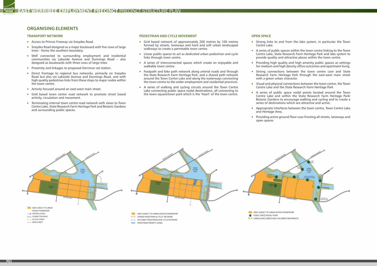
TRANSPORT NETWORK
• Access to Princes Freeway via Sneydes Road.
• Sneydes Road designed as a major boulevard with five rows of large trees - forms the southern boundary.
• Well connected to surrounding employment and residential communities via Lakeside Avenue and Dunnings Road – also designed as boulevards with three rows of large trees
• Proximity and linkages to proposed Derrimut rail station.
• Direct frontage to regional bus networks, primarily on Sneydes Road but also via Lakeside Avenue and Dunnings Road, and with high quality pedestrian links from these stops to major nodes within the town centre.
• Activity focused around an east-west main street.
• Grid based town centre road network to promote street based activity, circulation and movement.
• Terminating internal town centre road network with views to Town Centre Lake, State Research Farm Heritage Park and Botanic Gardens and surrounding public spaces.
PEDESTRIAN AND CYCLE MOVEMENT
• Grid based network of approximately 200 metres by 100 metres formed by streets, laneways and hard and soft urban landscaped walkways to create a permeable town centre.
• Linear public spaces to act as dedicated urban pedestrian and cycle links through town centre.
• A series of interconnected spaces which create an enjoyable and walkable town centre.
• Footpath and bike path network along arterial roads and through the State Research Farm Heritage Park, and a shared path network around the Town Centre Lake and along the waterways connecting the town centre to the wider employment and residential precincts.
• A series of walking and cycling circuits around the Town Centre Lake connecting public space nodal destinations, all connecting to the town square/town park which is the ‘heart’ of the town centre.
OPEN SPACE
• Strong links to and from the lake system, in particular the Town Centre Lake.
• A series of public spaces within the town centre linking to the Town Centre Lake, State Research Farm Heritage Park and lake system to provide quality and attractive places within the town centre.
• Providing high quality and high amenity public spaces as settings for medium and high density office outcomes and apartment living.
• Strong connections between the town centre core and State Research Farm Heritage Park through the east-west main street with a green urban character.
• Visual and physical connections between the town centre, the Town Centre Lake and the State Research Farm Heritage Park
• A series of public space nodal points located around the Town Centre Lake and within the State Research Farm Heritage Park/ Botanic Gardens to encourage walking and cycling and to create a series of destinations which are attractive and active.
• Appropriate interfaces between the town centre, Town Centre Lake and Heritage Area.
• Providing active ground floor uses fronting all streets, laneways and open spaces.
ORGANISING ELEMENTS
TOWN CENTRE
LAKE
SNEYDES ROAD DU
NN
ING
S RO
AD
LAKESIDE AVENUE
PRINCES HIGHWAY
EAST WERRIBEE EMPLOYMENT PRECINCTMAJOR TOWN CENTRE - ROAD NETWORK
Precinct Area
Urban Growth Boundary
Enterprise
Town Centre/Mixed use
Commercial/Mixed use
Commercial/Enterprise
Medium density residential
Conventional density residential
Health and Learning Precinct
Primary school
Utilities
Heritage
Active open space
Passive open space
Waterway corridor/Retarding Basin
Freeway and Interchange
Primary Arterial
Secondary Arterial Road
Boulevard Collector
Collector
Access Street
Reserve for potential future grade separation of arterial road
Rail line & station
Proposed station
HERITAGE AREA
AREA SUBJECT TO URBANDESIGN FRAMEWORKARTERIAL ROADCONNECTOR ROADACCESS STREETMAIN STREET
TOWN CENTRE
LAKE
DU
NN
ING
S RO
AD
LAKESIDE AVENUE
PRINCES HIGHWAY
SNEYDES ROAD
EAST WERRIBEE EMPLOYMENT PRECINCTMAJOR TOWN CENTRE
PEDESTRIAN AND CYCLE NETWORK
HERITAGE AREA
AREA SUBJECT TO URBAN DESIGN FRAMEWORKSHARED PEDESTRIAN & CYCLE NETWORKON STREET PEDESTRIAN AND CYCLE NETWORKPEDESTRIAN PRIORITY ZONES
TOWN CENTRE
LAKE
SNEYDES ROAD
DUNNINGS ROAD
LAKESIDE AVENUE
PRINCES HIGHWAY
HERITAGEAREA
GATEWAY TO HERITAGE CIVIC
PRECINCT
GATEWAY TO TOWN CENTRE
GATEWAY TO TOWN CENTRE
CENTRAL MEETINGSPACE/TOWN SQUARE
LAKENODE
LAKENODE
LAKENODE
PENINSULA NODE
EAST WERRIBEE EMPLOYMENT PRECINCTMAJOR TOWN CENTRE - OPEN SPACE
AREA SUBJECT TO URBAN DESIGN FRAMEWORKPUBLIC SPACE NODAL POINTLINEAR LINKS (GREEN AND/ OR URBAN TREATMENTS)
35
EAST WERRIBEE EMPLOYMENT PRECINCT PRECINCT STRUCTURE PLAN
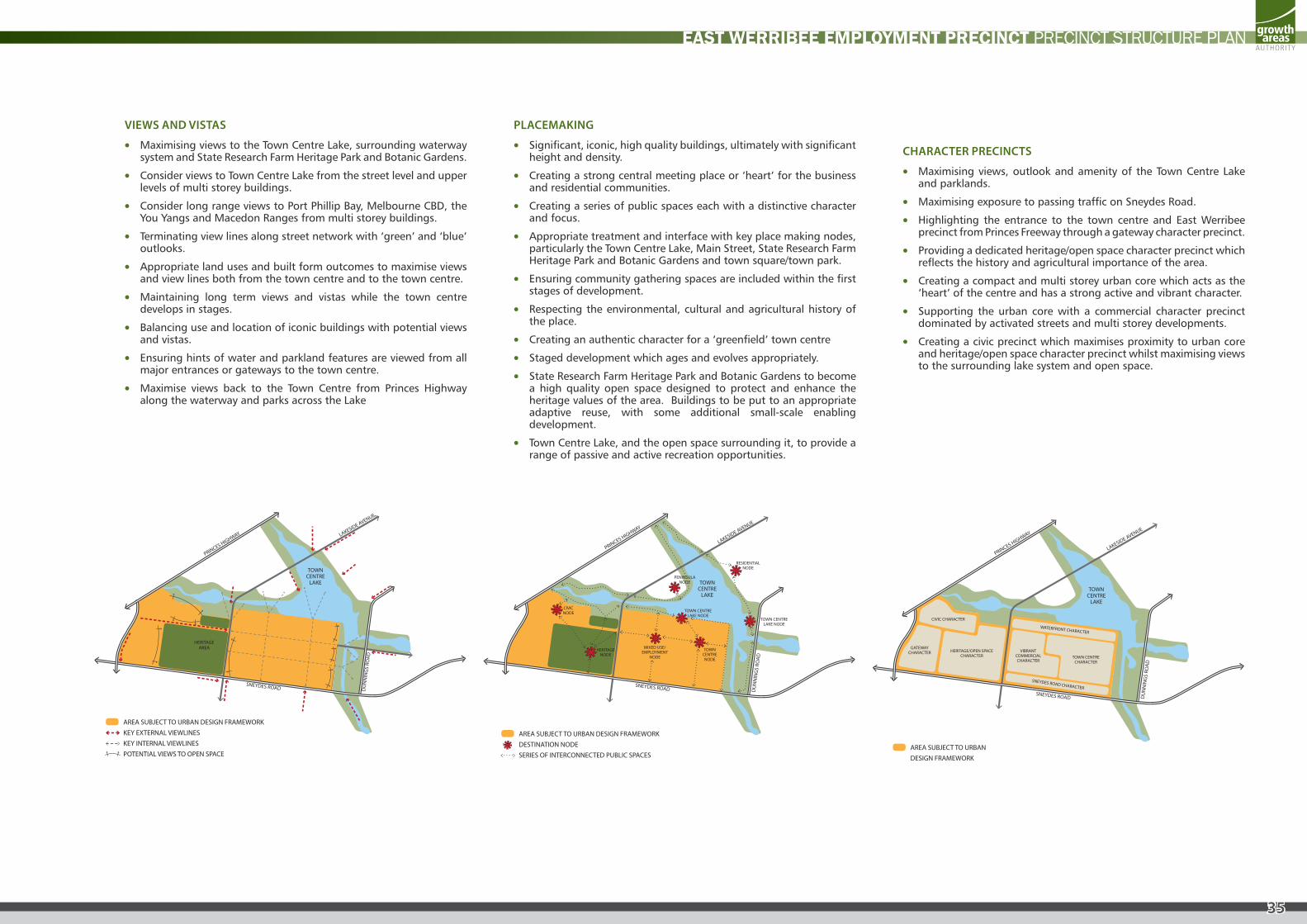
VIEWS AND VISTAS
• Maximising views to the Town Centre Lake, surrounding waterway system and State Research Farm Heritage Park and Botanic Gardens.
• Consider views to Town Centre Lake from the street level and upper levels of multi storey buildings.
• Consider long range views to Port Phillip Bay, Melbourne CBD, the You Yangs and Macedon Ranges from multi storey buildings.
• Terminating view lines along street network with ‘green’ and ‘blue’ outlooks.
• Appropriate land uses and built form outcomes to maximise views and view lines both from the town centre and to the town centre.
• Maintaining long term views and vistas while the town centre develops in stages.
• Balancing use and location of iconic buildings with potential views and vistas.
• Ensuring hints of water and parkland features are viewed from all major entrances or gateways to the town centre.
• Maximise views back to the Town Centre from Princes Highway along the waterway and parks across the Lake
PLACEMAKING
• Significant, iconic, high quality buildings, ultimately with significant height and density.
• Creating a strong central meeting place or ‘heart’ for the business and residential communities.
• Creating a series of public spaces each with a distinctive character and focus.
• Appropriate treatment and interface with key place making nodes, particularly the Town Centre Lake, Main Street, State Research Farm Heritage Park and Botanic Gardens and town square/town park.
• Ensuring community gathering spaces are included within the first stages of development.
• Respecting the environmental, cultural and agricultural history of the place.
• Creating an authentic character for a ‘greenfield’ town centre
• Staged development which ages and evolves appropriately.
• State Research Farm Heritage Park and Botanic Gardens to become a high quality open space designed to protect and enhance the heritage values of the area. Buildings to be put to an appropriate adaptive reuse, with some additional small-scale enabling development.
• Town Centre Lake, and the open space surrounding it, to provide a range of passive and active recreation opportunities.
CHARACTER PRECINCTS
• Maximising views, outlook and amenity of the Town Centre Lake and parklands.
• Maximising exposure to passing traffic on Sneydes Road.
• Highlighting the entrance to the town centre and East Werribee precinct from Princes Freeway through a gateway character precinct.
• Providing a dedicated heritage/open space character precinct which reflects the history and agricultural importance of the area.
• Creating a compact and multi storey urban core which acts as the ‘heart’ of the centre and has a strong active and vibrant character.
• Supporting the urban core with a commercial character precinct dominated by activated streets and multi storey developments.
• Creating a civic precinct which maximises proximity to urban core and heritage/open space character precinct whilst maximising views to the surrounding lake system and open space.
TOWN CENTRE
LAKE
SNEYDES ROAD DU
NN
ING
S RO
AD
LAKESIDE AVENUE
PRINCES HIGHWAY
EAST WERRIBEE EMPLOYMENT PRECINCTMAJOR TOWN CENTRE - VIEWS & VISTAS
HERITAGE AREA
AREA SUBJECT TO URBAN DESIGN FRAMEWORKKEY EXTERNAL VIEWLINESKEY INTERNAL VIEWLINESPOTENTIAL VIEWS TO OPEN SPACE
HERITAGENODE
CIVICNODE
RESIDENTIAL NODE
TOWN CENTRE LAKE NODE
TOWN CENTRE LAKE NODE
TOWNCENTRENODE
MIXED USE/EMPLOYMENT
NODE
PENINSULA NODE TOWN
CENTRE LAKE
SNEYDES ROAD DU
NN
ING
S RO
AD
LAKESIDE AVENUE
PRINCES HIGHWAY
EAST WERRIBEE EMPLOYMENT PRECINCTMAJOR TOWN CENTRE - PLACEMAKING ELEMENTS
AREA SUBJECT TO URBAN DESIGN FRAMEWORKDESTINATION NODESERIES OF INTERCONNECTED PUBLIC SPACES
GATEWAY CHARACTER
CIVIC CHARACTER
HERITAGE/OPEN SPACE CHARACTER
VIBRANT COMMERCIAL CHARACTER
TOWN CENTRECHARACTER
WATERFRONT CHARACTER
SNEYDES ROAD CHARACTER
TOWN CENTRE
LAKE
SNEYDES ROAD DU
NN
ING
S RO
AD
LAKESIDE AVENUE
PRINCES HIGHWAY
EAST WERRIBEE EMPLOYMENT PRECINCTMAJOR TOWN CENTRE - CHARACTER PRECINCTS
AREA SUBJECT TO URBANDESIGN FRAMEWORK
36
EAST WERRIBEE EMPLOYMENT PRECINCT PRECINCT STRUCTURE PLAN
REQUIREMENTS
R34
An Urban Design Framework Plan (UDF) must be approved by the Responsible Authority for the East Werribee Town Centre. The UDF applies to the East werribee Town Centre as shown on the Future Urban Structure Plan (plan 2).
The Urban Design Framework must address the following items:
• A response to the East Werribee Town Centre Concept Plan (Figure 2) and the vision and organising elements set out in this PSP;
• The role and function of the Town Centre as a whole;
• Appropriate land uses, their locations and relationships to the Town Centre;
• The location and integration of community facilities and services;
• The fine grain road network and how the network fosters connectivity within, to and from the Town Centre;
• Appropriate building heights
• The incorporation of public transport services, including a bus interchange, into the design of the Town Centre;
• The retention and enhancement of the natural environment and its integration into the Town Centre design;
• A hierarchy of public spaces including active recreation, passive recreation, conservation areas, pedestrian and cycle links, urban spaces and landscape nodes. An overall landscape concept must be included within the Urban Design Framework;
• Placemaking elements, character precincts and nodal destinations within the Town Centre including a central meeting space within the urban core of the Town Centre (such as a town square, urban park or plaza space);
• Opportunities for higher density housing and how this can be incorporated into the design of the Town Centre; and
• The staging and indicative development timing of the Town Centre.
Specifically the East Werribee Town Centre Urban Design Framework must:
• Demonstrate an appropriate design response that addresses the East Werribee Town Centre vision, principles, objectives and organising elements outlined within this document;
• Address any relevant design guidelines prepared by the Victorian Government or by Wyndham City Council;
• Explain how the Urban Design Framework responds to feedback received following consultation with infrastructure agencies including VicRoads, the Growth Areas Authority and the Department of Transport;
• Show how the Town Centre relates to the existing or approved developments in the area;
• Set out guidelines to positively address environmental sustainability including integrated water management and energy conservation;
• Set out provisions for car parking including the location and design of the car parking areas and car parking rates for proposed uses within the Town Centre;
• Set out arrangements for the provision of service areas for deliveries and waste disposal including access for larger vehicles and measures to minimise the impact on the amenity of the Town Centre and adjoining neighbourhoods;
• Set out design guidelines for the provision of advertising signs; and
• Set out clear and specific strategies, actions and guidelines for the development of the East Werribee Major Town Centre which will form the assessment tool for future development applications for the Town Centre.
37
EAST WERRIBEE EMPLOYMENT PRECINCT PRECINCT STRUCTURE PLAN
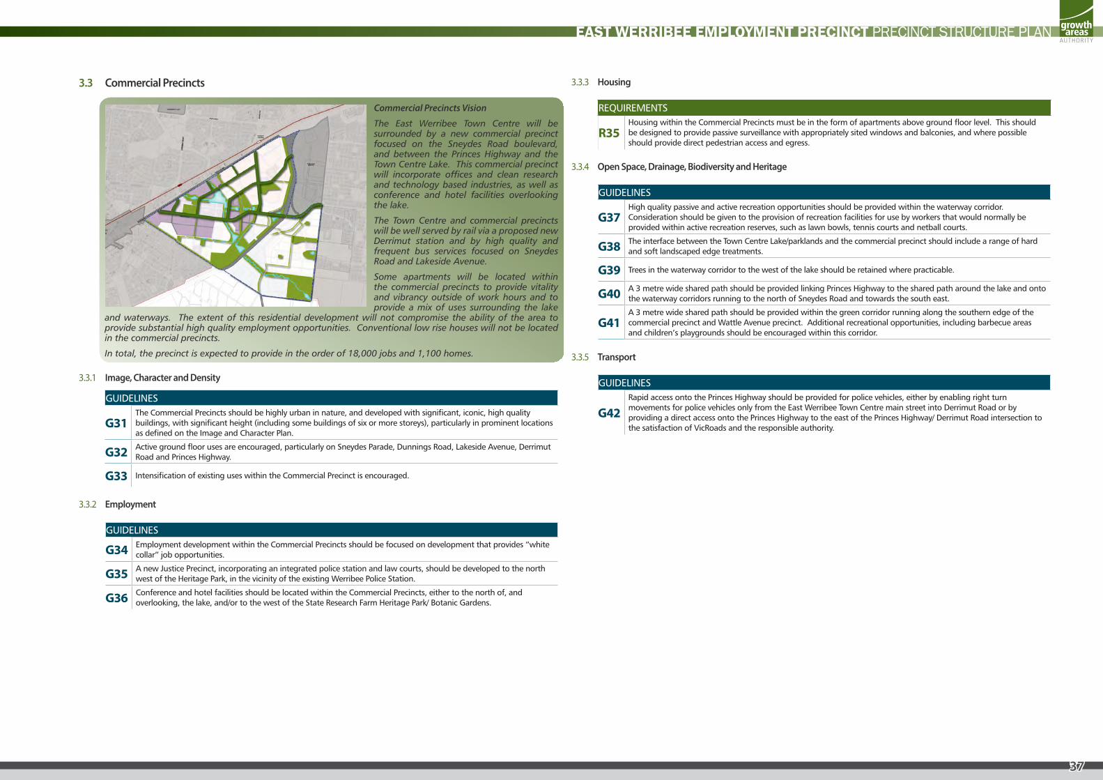
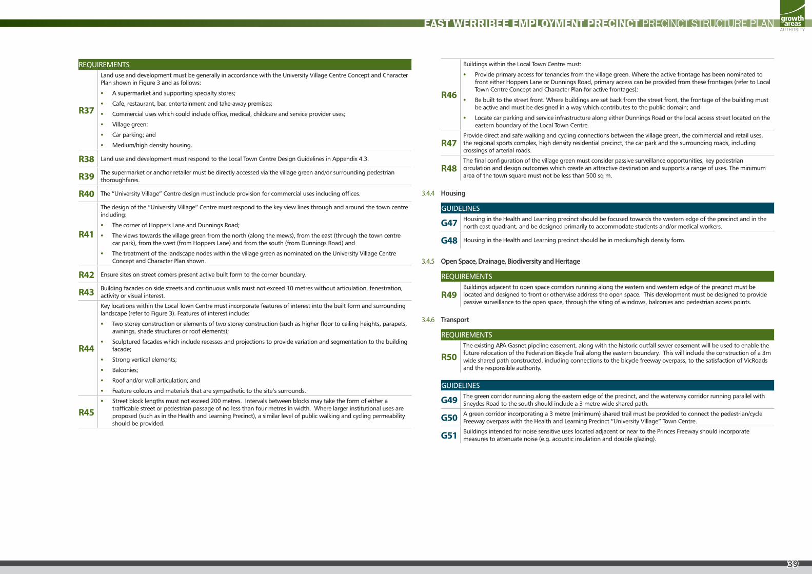
3.3 Commercial Precincts
Commercial Precincts Vision
The East Werribee Town Centre will be surrounded by a new commercial precinct focused on the Sneydes Road boulevard, and between the Princes Highway and the Town Centre Lake. This commercial precinct will incorporate offices and clean research and technology based industries, as well as conference and hotel facilities overlooking the lake.
The Town Centre and commercial precincts will be well served by rail via a proposed new Derrimut station and by high quality and frequent bus services focused on Sneydes Road and Lakeside Avenue.
Some apartments will be located within the commercial precincts to provide vitality and vibrancy outside of work hours and to provide a mix of uses surrounding the lake
and waterways. The extent of this residential development will not compromise the ability of the area to provide substantial high quality employment opportunities. Conventional low rise houses will not be located in the commercial precincts.
In total, the precinct is expected to provide in the order of 18,000 jobs and 1,100 homes.
3.3.1 Image, Character and Density
GUIDELINES
G31 The Commercial Precincts should be highly urban in nature, and developed with significant, iconic, high quality buildings, with significant height (including some buildings of six or more storeys), particularly in prominent locations as defined on the Image and Character Plan.
G32 Active ground floor uses are encouraged, particularly on Sneydes Parade, Dunnings Road, Lakeside Avenue, Derrimut Road and Princes Highway.
G33 Intensification of existing uses within the Commercial Precinct is encouraged.
3.3.2 Employment
GUIDELINES
G34 Employment development within the Commercial Precincts should be focused on development that provides “white collar” job opportunities.
G35 A new Justice Precinct, incorporating an integrated police station and law courts, should be developed to the north west of the Heritage Park, in the vicinity of the existing Werribee Police Station.
G36 Conference and hotel facilities should be located within the Commercial Precincts, either to the north of, and overlooking, the lake, and/or to the west of the State Research Farm Heritage Park/ Botanic Gardens.
3.3.3 Housing
REQUIREMENTS
R35 Housing within the Commercial Precincts must be in the form of apartments above ground floor level. This should be designed to provide passive surveillance with appropriately sited windows and balconies, and where possible should provide direct pedestrian access and egress.
3.3.4 Open Space, Drainage, Biodiversity and Heritage
GUIDELINES
G37 High quality passive and active recreation opportunities should be provided within the waterway corridor. Consideration should be given to the provision of recreation facilities for use by workers that would normally be provided within active recreation reserves, such as lawn bowls, tennis courts and netball courts.
G38 The interface between the Town Centre Lake/parklands and the commercial precinct should include a range of hard and soft landscaped edge treatments.
G39 Trees in the waterway corridor to the west of the lake should be retained where practicable.
G40 A 3 metre wide shared path should be provided linking Princes Highway to the shared path around the lake and onto the waterway corridors running to the north of Sneydes Road and towards the south east.
G41 A 3 metre wide shared path should be provided within the green corridor running along the southern edge of the commercial precinct and Wattle Avenue precinct. Additional recreational opportunities, including barbecue areas and children’s playgrounds should be encouraged within this corridor.
3.3.5 Transport
GUIDELINES
G42 Rapid access onto the Princes Highway should be provided for police vehicles, either by enabling right turn movements for police vehicles only from the East Werribee Town Centre main street into Derrimut Road or by providing a direct access onto the Princes Highway to the east of the Princes Highway/ Derrimut Road intersection to the satisfaction of VicRoads and the responsible authority.
38
EAST WERRIBEE EMPLOYMENT PRECINCT PRECINCT STRUCTURE PLAN
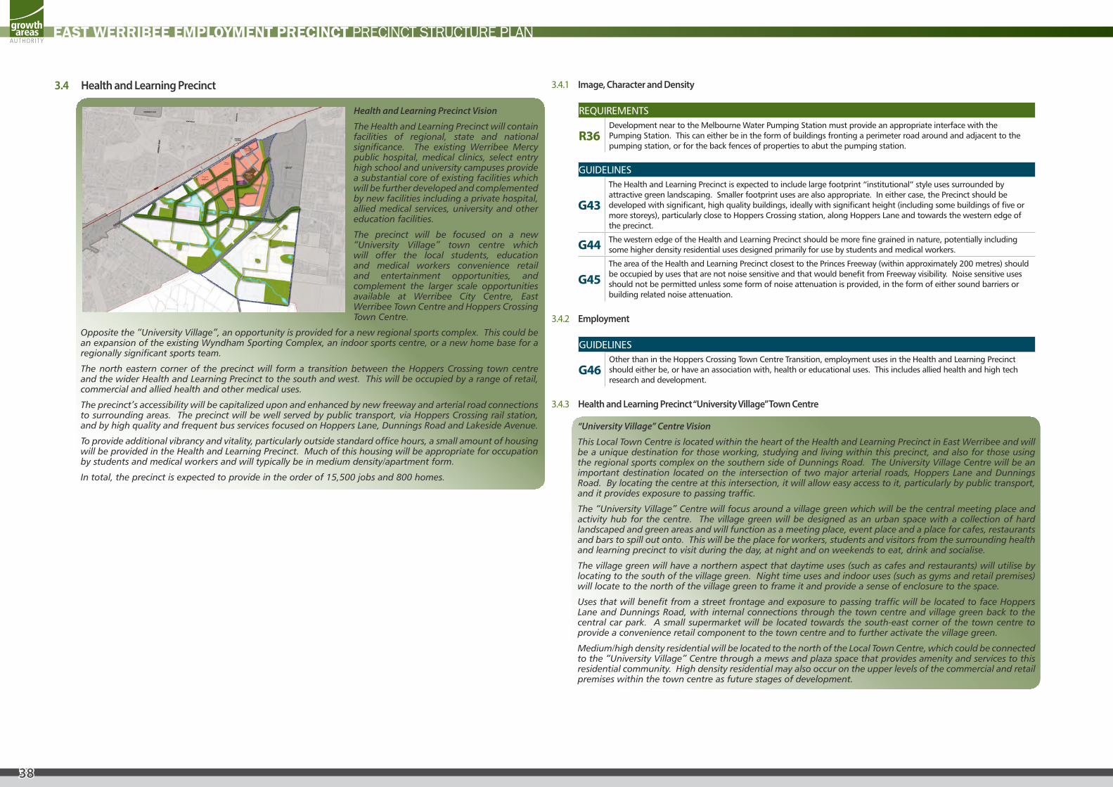
3.4 Health and Learning Precinct
Health and Learning Precinct Vision
The Health and Learning Precinct will contain facilities of regional, state and national significance. The existing Werribee Mercy public hospital, medical clinics, select entry high school and university campuses provide a substantial core of existing facilities which will be further developed and complemented by new facilities including a private hospital, allied medical services, university and other education facilities.
The precinct will be focused on a new “University Village” town centre which will offer the local students, education and medical workers convenience retail and entertainment opportunities, and complement the larger scale opportunities available at Werribee City Centre, East Werribee Town Centre and Hoppers Crossing Town Centre.
Opposite the “University Village”, an opportunity is provided for a new regional sports complex. This could be an expansion of the existing Wyndham Sporting Complex, an indoor sports centre, or a new home base for a regionally significant sports team.
The north eastern corner of the precinct will form a transition between the Hoppers Crossing town centre and the wider Health and Learning Precinct to the south and west. This will be occupied by a range of retail, commercial and allied health and other medical uses.
The precinct’s accessibility will be capitalized upon and enhanced by new freeway and arterial road connections to surrounding areas. The precinct will be well served by public transport, via Hoppers Crossing rail station, and by high quality and frequent bus services focused on Hoppers Lane, Dunnings Road and Lakeside Avenue.
To provide additional vibrancy and vitality, particularly outside standard office hours, a small amount of housing will be provided in the Health and Learning Precinct. Much of this housing will be appropriate for occupation by students and medical workers and will typically be in medium density/apartment form.
In total, the precinct is expected to provide in the order of 15,500 jobs and 800 homes.
3.4.1 Image, Character and Density
REQUIREMENTS
R36 Development near to the Melbourne Water Pumping Station must provide an appropriate interface with the Pumping Station. This can either be in the form of buildings fronting a perimeter road around and adjacent to the pumping station, or for the back fences of properties to abut the pumping station.
GUIDELINES
G43
The Health and Learning Precinct is expected to include large footprint “institutional” style uses surrounded by attractive green landscaping. Smaller footprint uses are also appropriate. In either case, the Precinct should be developed with significant, high quality buildings, ideally with significant height (including some buildings of five or more storeys), particularly close to Hoppers Crossing station, along Hoppers Lane and towards the western edge of the precinct.
G44 The western edge of the Health and Learning Precinct should be more fine grained in nature, potentially including some higher density residential uses designed primarily for use by students and medical workers.
G45 The area of the Health and Learning Precinct closest to the Princes Freeway (within approximately 200 metres) should be occupied by uses that are not noise sensitive and that would benefit from Freeway visibility. Noise sensitive uses should not be permitted unless some form of noise attenuation is provided, in the form of either sound barriers or building related noise attenuation.
3.4.2 Employment
GUIDELINES
G46 Other than in the Hoppers Crossing Town Centre Transition, employment uses in the Health and Learning Precinct should either be, or have an association with, health or educational uses. This includes allied health and high tech research and development.
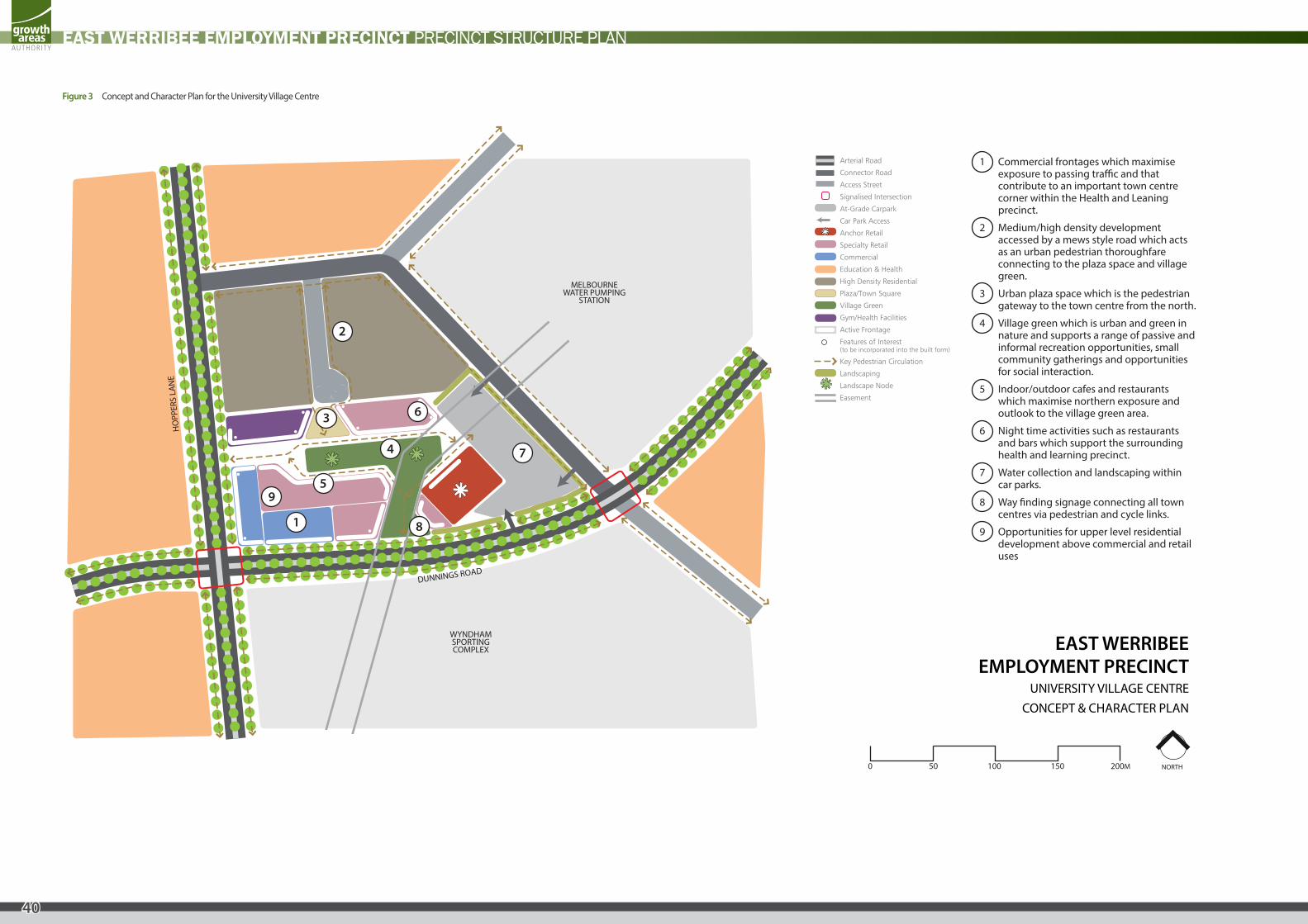
3.4.3 Health and Learning Precinct “University Village” Town Centre
“University Village” Centre Vision
This Local Town Centre is located within the heart of the Health and Learning Precinct in East Werribee and will be a unique destination for those working, studying and living within this precinct, and also for those using the regional sports complex on the southern side of Dunnings Road. The University Village Centre will be an important destination located on the intersection of two major arterial roads, Hoppers Lane and Dunnings Road. By locating the centre at this intersection, it will allow easy access to it, particularly by public transport, and it provides exposure to passing traffic.
The “University Village” Centre will focus around a village green which will be the central meeting place and activity hub for the centre. The village green will be designed as an urban space with a collection of hard landscaped and green areas and will function as a meeting place, event place and a place for cafes, restaurants and bars to spill out onto. This will be the place for workers, students and visitors from the surrounding health and learning precinct to visit during the day, at night and on weekends to eat, drink and socialise.
The village green will have a northern aspect that daytime uses (such as cafes and restaurants) will utilise by locating to the south of the village green. Night time uses and indoor uses (such as gyms and retail premises) will locate to the north of the village green to frame it and provide a sense of enclosure to the space.
Uses that will benefit from a street frontage and exposure to passing traffic will be located to face Hoppers Lane and Dunnings Road, with internal connections through the town centre and village green back to the central car park. A small supermarket will be located towards the south-east corner of the town centre to provide a convenience retail component to the town centre and to further activate the village green.
Medium/high density residential will be located to the north of the Local Town Centre, which could be connected to the “University Village” Centre through a mews and plaza space that provides amenity and services to this residential community. High density residential may also occur on the upper levels of the commercial and retail premises within the town centre as future stages of development.
39
EAST WERRIBEE EMPLOYMENT PRECINCT PRECINCT STRUCTURE PLAN
REQUIREMENTS
R37
Land use and development must be generally in accordance with the University Village Centre Concept and Character Plan shown in Figure 3 and as follows:
• A supermarket and supporting specialty stores;
• Cafe, restaurant, bar, entertainment and take-away premises;
• Commercial uses which could include office, medical, childcare and service provider uses;
• Village green;
• Car parking; and
• Medium/high density housing.
R38 Land use and development must respond to the Local Town Centre Design Guidelines in Appendix 4.3.
R39 The supermarket or anchor retailer must be directly accessed via the village green and/or surrounding pedestrian thoroughfares.
R40 The “University Village” Centre design must include provision for commercial uses including offices.
R41
The design of the “University Village” Centre must respond to the key view lines through and around the town centre including:
• The corner of Hoppers Lane and Dunnings Road;
• The views towards the village green from the north (along the mews), from the east (through the town centre car park), from the west (from Hoppers Lane) and from the south (from Dunnings Road) and
• The treatment of the landscape nodes within the village green as nominated on the University Village Centre Concept and Character Plan shown.
R42 Ensure sites on street corners present active built form to the corner boundary.
R43 Building facades on side streets and continuous walls must not exceed 10 metres without articulation, fenestration, activity or visual interest.
R44
Key locations within the Local Town Centre must incorporate features of interest into the built form and surrounding landscape (refer to Figure 3). Features of interest include:
• Two storey construction or elements of two storey construction (such as higher floor to ceiling heights, parapets, awnings, shade structures or roof elements);
• Sculptured facades which include recesses and projections to provide variation and segmentation to the building facade;
• Strong vertical elements;
• Balconies;
• Roof and/or wall articulation; and
• Feature colours and materials that are sympathetic to the site’s surrounds.
R45 • Street block lengths must not exceed 200 metres. Intervals between blocks may take the form of either a
trafficable street or pedestrian passage of no less than four metres in width. Where larger institutional uses are proposed (such as in the Health and Learning Precinct), a similar level of public walking and cycling permeability should be provided.
R46
Buildings within the Local Town Centre must:
• Provide primary access for tenancies from the village green. Where the active frontage has been nominated to front either Hoppers Lane or Dunnings Road, primary access can be provided from these frontages (refer to Local Town Centre Concept and Character Plan for active frontages);
• Be built to the street front. Where buildings are set back from the street front, the frontage of the building must be active and must be designed in a way which contributes to the public domain; and
• Locate car parking and service infrastructure along either Dunnings Road or the local access street located on the eastern boundary of the Local Town Centre.
R47 Provide direct and safe walking and cycling connections between the village green, the commercial and retail uses, the regional sports complex, high density residential precinct, the car park and the surrounding roads, including crossings of arterial roads.
R48 The final configuration of the village green must consider passive surveillance opportunities, key pedestrian circulation and design outcomes which create an attractive destination and supports a range of uses. The minimum area of the town square must not be less than 500 sq m.
3.4.4 Housing
GUIDELINES
G47 Housing in the Health and Learning precinct should be focused towards the western edge of the precinct and in the north east quadrant, and be designed primarily to accommodate students and/or medical workers.
G48 Housing in the Health and Learning precinct should be in medium/high density form.
3.4.5 Open Space, Drainage, Biodiversity and Heritage
REQUIREMENTS
R49 Buildings adjacent to open space corridors running along the eastern and western edge of the precinct must be located and designed to front or otherwise address the open space. This development must be designed to provide passive surveillance to the open space, through the siting of windows, balconies and pedestrian access points.
3.4.6 Transport
REQUIREMENTS
R50 The existing APA Gasnet pipeline easement, along with the historic outfall sewer easement will be used to enable the future relocation of the Federation Bicycle Trail along the eastern boundary. This will include the construction of a 3m wide shared path constructed, including connections to the bicycle freeway overpass, to the satisfaction of VicRoads and the responsible authority.
GUIDELINES
G49 The green corridor running along the eastern edge of the precinct, and the waterway corridor running parallel with Sneydes Road to the south should include a 3 metre wide shared path.
G50 A green corridor incorporating a 3 metre (minimum) shared trail must be provided to connect the pedestrian/cycle Freeway overpass with the Health and Learning Precinct “University Village” Town Centre.
G51 Buildings intended for noise sensitive uses located adjacent or near to the Princes Freeway should incorporate measures to attenuate noise (e.g. acoustic insulation and double glazing).
40
EAST WERRIBEE EMPLOYMENT PRECINCT PRECINCT STRUCTURE PLAN
HO
PPER
S LA
NE
DUNNINGS ROAD
MELBOURNEWATER PUMPING
STATION
WYNDHAM SPORTING COMPLEX
Arterial Road
Connector Road
Access Street
Signalised Intersection
At-Grade Carpark
Car Park Access
Anchor Retail
Specialty Retail
Commercial
Education & Health
High Density Residential
Plaza/Town Square
Village Green
Gym/Health Facilities
Active Frontage
Features of Interest(to be incorporated into the built form)
Key Pedestrian Circulation
Landscaping
Landscape Node
Easement
NORTH
EAST WERRIBEEEMPLOYMENT PRECINCT
UNIVERSITY VILLAGE CENTRECONCEPT & CHARACTER PLAN
1
2
3
4
6
7
8
95
1 Commercial frontages which maximise exposure to passing tra�c and that contribute to an important town centre corner within the Health and Leaning precinct.
2 Medium/high density development accessed by a mews style road which acts as an urban pedestrian thoroughfare connecting to the plaza space and village green.
3 Urban plaza space which is the pedestrian gateway to the town centre from the north.
4 Village green which is urban and green in nature and supports a range of passive and informal recreation opportunities, small community gatherings and opportunities for social interaction.
5 Indoor/outdoor cafes and restaurants which maximise northern exposure and outlook to the village green area.
6 Night time activities such as restaurants and bars which support the surrounding health and learning precinct.
7 Water collection and landscaping within car parks.
8 Way �nding signage connecting all town centres via pedestrian and cycle links.
9 Opportunities for upper level residential development above commercial and retail uses
0 50 100 150 200M
Figure 3 Concept and Character Plan for the University Village Centre
41
EAST WERRIBEE EMPLOYMENT PRECINCT PRECINCT STRUCTURE PLAN
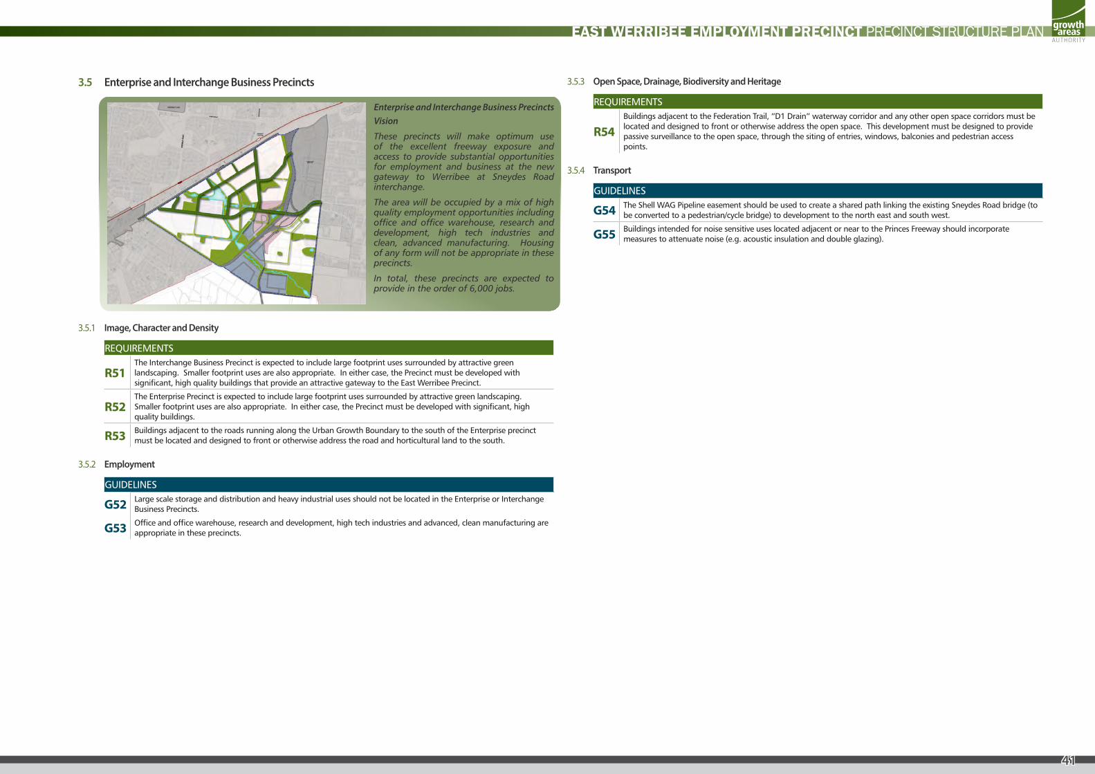
3.5 Enterprise and Interchange Business Precincts
Enterprise and Interchange Business Precincts Vision
These precincts will make optimum use of the excellent freeway exposure and access to provide substantial opportunities for employment and business at the new gateway to Werribee at Sneydes Road interchange.
The area will be occupied by a mix of high quality employment opportunities including office and office warehouse, research and development, high tech industries and clean, advanced manufacturing. Housing of any form will not be appropriate in these precincts.
In total, these precincts are expected to provide in the order of 6,000 jobs.
3.5.1 Image, Character and Density
REQUIREMENTS
R51 The Interchange Business Precinct is expected to include large footprint uses surrounded by attractive green landscaping. Smaller footprint uses are also appropriate. In either case, the Precinct must be developed with significant, high quality buildings that provide an attractive gateway to the East Werribee Precinct.
R52 The Enterprise Precinct is expected to include large footprint uses surrounded by attractive green landscaping. Smaller footprint uses are also appropriate. In either case, the Precinct must be developed with significant, high quality buildings.
R53 Buildings adjacent to the roads running along the Urban Growth Boundary to the south of the Enterprise precinct must be located and designed to front or otherwise address the road and horticultural land to the south.
3.5.2 Employment
GUIDELINES
G52 Large scale storage and distribution and heavy industrial uses should not be located in the Enterprise or Interchange Business Precincts.
G53 Office and office warehouse, research and development, high tech industries and advanced, clean manufacturing are appropriate in these precincts.
3.5.3 Open Space, Drainage, Biodiversity and Heritage
REQUIREMENTS
R54 Buildings adjacent to the Federation Trail, “D1 Drain” waterway corridor and any other open space corridors must be located and designed to front or otherwise address the open space. This development must be designed to provide passive surveillance to the open space, through the siting of entries, windows, balconies and pedestrian access points.
3.5.4 Transport
GUIDELINES
G54 The Shell WAG Pipeline easement should be used to create a shared path linking the existing Sneydes Road bridge (to be converted to a pedestrian/cycle bridge) to development to the north east and south west.
G55 Buildings intended for noise sensitive uses located adjacent or near to the Princes Freeway should incorporate measures to attenuate noise (e.g. acoustic insulation and double glazing).
42
EAST WERRIBEE EMPLOYMENT PRECINCT PRECINCT STRUCTURE PLAN
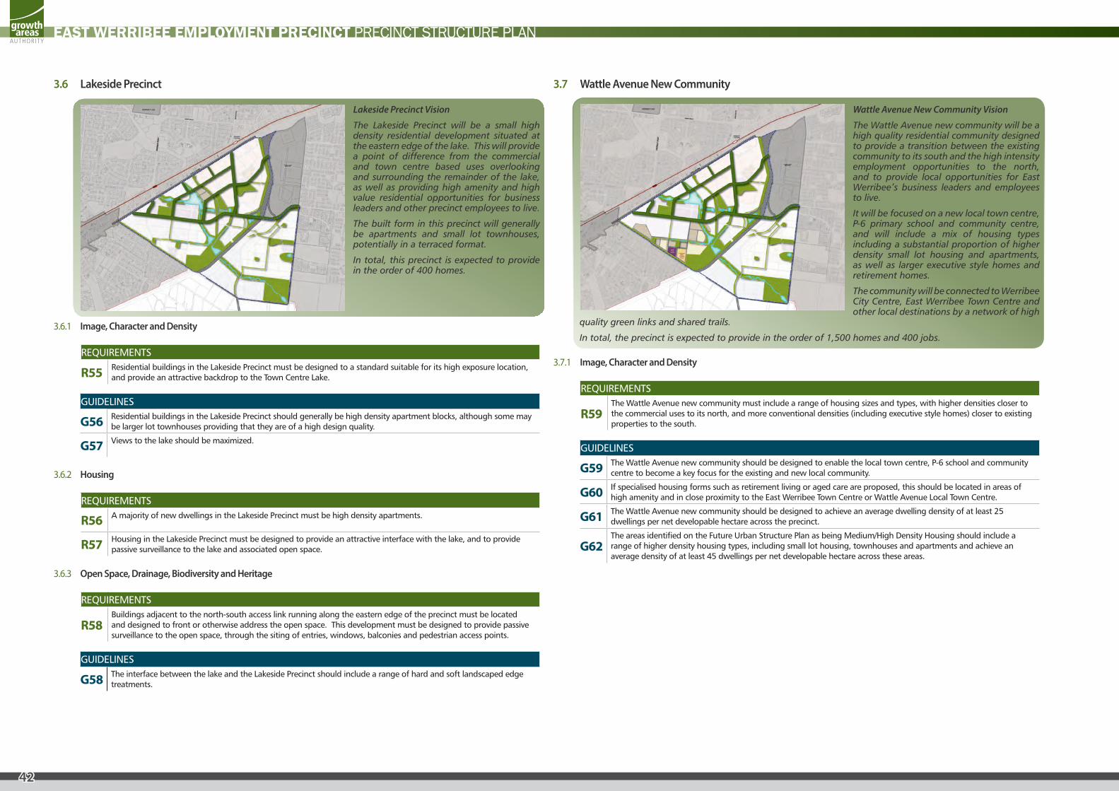
3.6 Lakeside Precinct
Lakeside Precinct Vision
The Lakeside Precinct will be a small high density residential development situated at the eastern edge of the lake. This will provide a point of difference from the commercial and town centre based uses overlooking and surrounding the remainder of the lake, as well as providing high amenity and high value residential opportunities for business leaders and other precinct employees to live.
The built form in this precinct will generally be apartments and small lot townhouses, potentially in a terraced format.
In total, this precinct is expected to provide in the order of 400 homes.
3.6.1 Image, Character and Density
REQUIREMENTS
R55 Residential buildings in the Lakeside Precinct must be designed to a standard suitable for its high exposure location, and provide an attractive backdrop to the Town Centre Lake.
GUIDELINES
G56 Residential buildings in the Lakeside Precinct should generally be high density apartment blocks, although some may be larger lot townhouses providing that they are of a high design quality.
G57 Views to the lake should be maximized.
3.6.2 Housing
REQUIREMENTS
R56 A majority of new dwellings in the Lakeside Precinct must be high density apartments.
R57 Housing in the Lakeside Precinct must be designed to provide an attractive interface with the lake, and to provide passive surveillance to the lake and associated open space.
3.6.3 Open Space, Drainage, Biodiversity and Heritage
REQUIREMENTS
R58 Buildings adjacent to the north-south access link running along the eastern edge of the precinct must be located and designed to front or otherwise address the open space. This development must be designed to provide passive surveillance to the open space, through the siting of entries, windows, balconies and pedestrian access points.
GUIDELINES
G58 The interface between the lake and the Lakeside Precinct should include a range of hard and soft landscaped edge treatments.
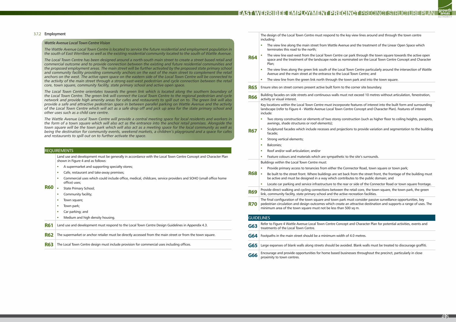
3.7 Wattle Avenue New Community
Wattle Avenue New Community Vision
The Wattle Avenue new community will be a high quality residential community designed to provide a transition between the existing community to its south and the high intensity employment opportunities to the north, and to provide local opportunities for East Werribee’s business leaders and employees to live.
It will be focused on a new local town centre, P-6 primary school and community centre, and will include a mix of housing types including a substantial proportion of higher density small lot housing and apartments, as well as larger executive style homes and retirement homes.
The community will be connected to Werribee City Centre, East Werribee Town Centre and other local destinations by a network of high
quality green links and shared trails.
In total, the precinct is expected to provide in the order of 1,500 homes and 400 jobs.
3.7.1 Image, Character and Density
REQUIREMENTS
R59 The Wattle Avenue new community must include a range of housing sizes and types, with higher densities closer to the commercial uses to its north, and more conventional densities (including executive style homes) closer to existing properties to the south.
GUIDELINES
G59 The Wattle Avenue new community should be designed to enable the local town centre, P-6 school and community centre to become a key focus for the existing and new local community.
G60 If specialised housing forms such as retirement living or aged care are proposed, this should be located in areas of high amenity and in close proximity to the East Werribee Town Centre or Wattle Avenue Local Town Centre.
G61 The Wattle Avenue new community should be designed to achieve an average dwelling density of at least 25 dwellings per net developable hectare across the precinct.
G62 The areas identified on the Future Urban Structure Plan as being Medium/High Density Housing should include a range of higher density housing types, including small lot housing, townhouses and apartments and achieve an average density of at least 45 dwellings per net developable hectare across these areas.
43
EAST WERRIBEE EMPLOYMENT PRECINCT PRECINCT STRUCTURE PLAN
3.7.2 Employment
Wattle Avenue Local Town Centre Vision
The Wattle Avenue Local Town Centre is located to service the future residential and employment population in the south of East Werribee as well as the existing residential community located to the south of Wattle Avenue.
The Local Town Centre has been designed around a north-south main street to create a street based retail and commercial outcome and to provide connection between the existing and future residential communities and the proposed employment areas. The main street will be further activated by the proposed state primary school and community facility providing community anchors on the east of the main street to complement the retail anchors on the west. The active open space on the eastern side of the Local Town Centre will be connected to the activity of the main street through a strong east-west pedestrian and cycle connection between the retail core, town square, community facility, state primary school and active open space.
The Local Town Centre orientates towards the green link which is located along the southern boundary of the Local Town Centre. The green link will connect the Local Town Centre to the regional pedestrian and cycle network and provide high amenity areas for cafes and restaurants to spill out on to. The green link will also provide a safe and attractive pedestrian space in between parallel parking on Wattle Avenue and the activity of the Local Town Centre which will act as a safe drop off and pick up area for the state primary school and other uses such as a child care centre.
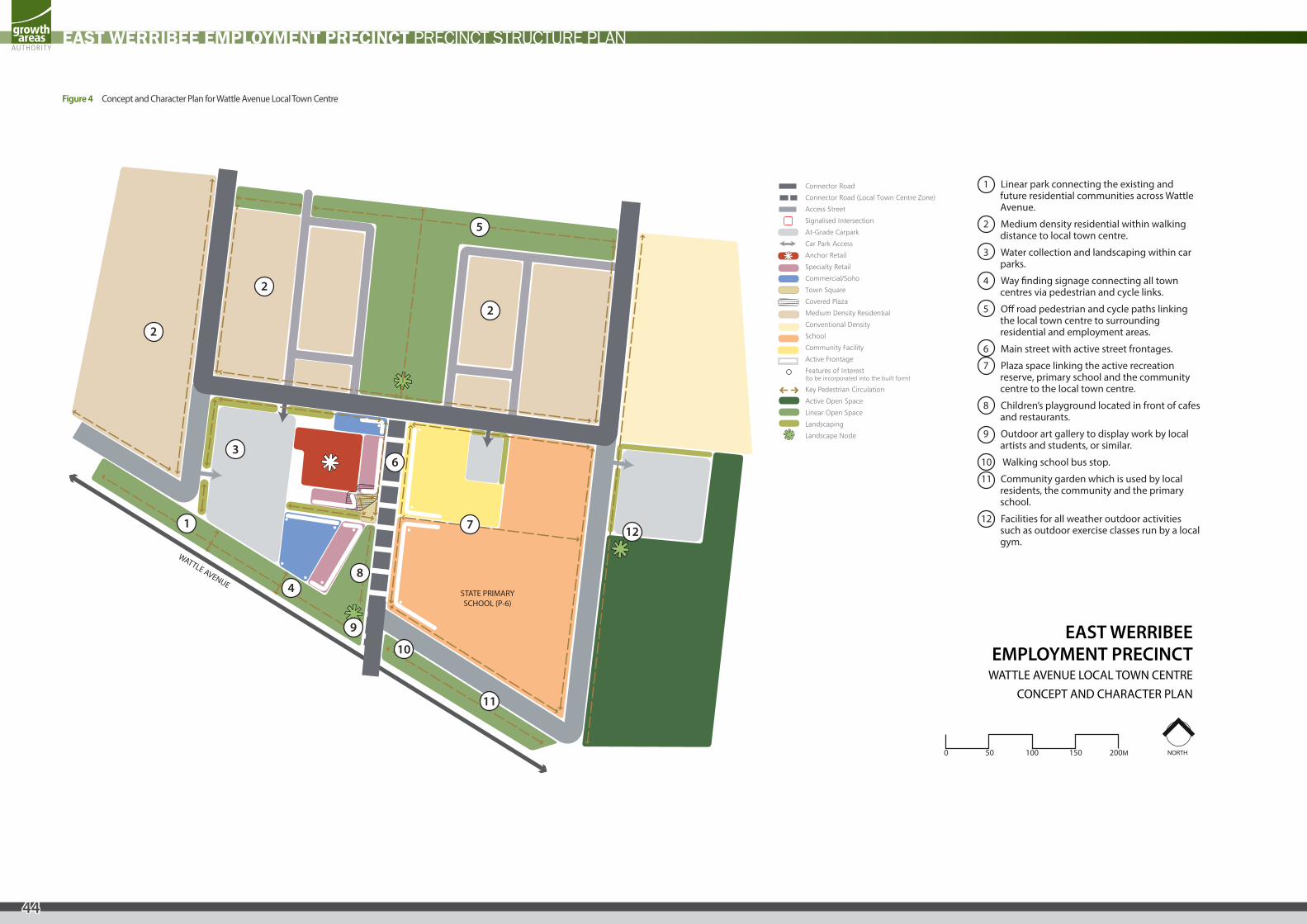
The Wattle Avenue Local Town Centre will provide a central meeting space for local residents and workers in the form of a town square which will also act as the entrance into the anchor retail premises. Alongside the town square will be the town park which will also act as a meeting space for the local community as well as being the destination for community events, weekend markets, a children’s playground and a space for cafes and restaurants to spill out on to further activate the space.
REQUIREMENTS
R60
Land use and development must be generally in accordance with the Local Town Centre Concept and Character Plan shown in Figure 4 and as follows:
• A supermarket and supporting specialty stores;
• Cafe, restaurant and take-away premises;
• Commercial uses which could include office, medical, childcare, service providers and SOHO (small office home office) uses;
• State Primary School;
• Community facility;
• Town square;
• Town park;
• Car parking; and
• Medium and high density housing.
R61 Land use and development must respond to the Local Town Centre Design Guidelines in Appendix 4.3.
R62 The supermarket or anchor retailer must be directly accessed from the main street or from the town square.
R63 The Local Town Centre design must include provision for commercial uses including offices.
R64
The design of the Local Town Centre must respond to the key view lines around and through the town centre including:
• The view line along the main street from Wattle Avenue and the treatment of the Linear Open Space which terminates this road to the north;
• The view line east-west from the Local Town Centre car park through the town square towards the active open space and the treatment of the landscape node as nominated on the Local Town Centre Concept and Character Plan;
• The view lines along the green link south of the Local Town Centre particularly around the intersection of Wattle Avenue and the main street at the entrance to the Local Town Centre; and
• The view line from the green link north through the town park and into the town square.
R65 Ensure sites on street corners present active built form to the corner site boundary.
R66 Building facades on side streets and continuous walls must not exceed 10 metres without articulation, fenestration, activity or visual interest.
R67
Key locations within the Local Town Centre must incorporate features of interest into the built form and surrounding landscape (refer to Figure 4 - Wattle Avenue Local Town Centre Concept and Character Plan). Features of interest include:
• Two storey construction or elements of two storey construction (such as higher floor to ceiling heights, parapets, awnings, shade structures or roof elements);
• Sculptured facades which include recesses and projections to provide variation and segmentation to the building facade;
• Strong vertical elements;
• Balconies;
• Roof and/or wall articulation; and/or
• Feature colours and materials which are sympathetic to the site’s surrounds.
R68
Buildings within the Local Town Centre must:
• Provide primary access to tenancies from either the Connector Road, town square or town park;
• Be built to the street front. Where buildings are set back from the street front, the frontage of the building must be active and must be designed in a way which contributes to the public domain; and
• Locate car parking and service infrastructure to the rear or side of the Connector Road or town square frontage.
R69 Provide direct walking and cycling connections between the retail core, the town square, the town park, the green link, community facility, state primary school and the active recreation facilities.
R70 The final configuration of the town square and town park must consider passive surveillance opportunities, key pedestrian circulation and design outcomes which create an attractive destination and supports a range of uses. The minimum area of the town square must not be less than 500 sq m.
GUIDELINES
G63 Refer to Figure 4 Wattle Avenue Local Town Centre Concept and Character Plan for potential activities, events and treatments of the Local Town Centre.
G64 Footpaths in the main street should be a minimum width of 4.0 metres.
G65 Large expanses of blank walls along streets should be avoided. Blank walls must be treated to discourage graffiti.
G66 Encourage and provide opportunities for home based businesses throughout the precinct, particularly in close proximity to town centres.
44
EAST WERRIBEE EMPLOYMENT PRECINCT PRECINCT STRUCTURE PLAN
STATE PRIMARYSCHOOL (P-6)
WATTLE AVENUE
Connector Road
Connector Road (Local Town Centre Zone)
Access Street
Signalised Intersection
At-Grade Carpark
Car Park Access
Anchor Retail
Specialty Retail
Commercial/Soho
Town Square
Covered Plaza
Medium Density Residential
Conventional Density
School
Community Facility
Active Frontage
Features of Interest(to be incorporated into the built form)
Key Pedestrian Circulation
Active Open Space
Linear Open Space
Landscaping
Landscape Node
NORTH
EAST WERRIBEEEMPLOYMENT PRECINCT
WATTLE AVENUE LOCAL TOWN CENTRECONCEPT AND CHARACTER PLAN
1
2
2
2
3
4
6
5
7
8
9
10
11
12
1 Linear park connecting the existing and future residential communities across Wattle Avenue.
2 Medium density residential within walking distance to local town centre.
3 Water collection and landscaping within car parks.
4 Way �nding signage connecting all town centres via pedestrian and cycle links.
5 O� road pedestrian and cycle paths linking the local town centre to surrounding residential and employment areas.
6 Main street with active street frontages.
7 Plaza space linking the active recreation reserve, primary school and the community centre to the local town centre.
8 Children’s playground located in front of cafes and restaurants.
9 Outdoor art gallery to display work by local artists and students, or similar.
10 Walking school bus stop.
11 Community garden which is used by local residents, the community and the primary school.
12 Facilities for all weather outdoor activities such as outdoor exercise classes run by a local gym.
0 50 100 150 200M
Figure 4 Concept and Character Plan for Wattle Avenue Local Town Centre
45
EAST WERRIBEE EMPLOYMENT PRECINCT PRECINCT STRUCTURE PLAN
3.7.3 Community Facilities
REQUIREMENTS
R71 Space must be provided within the Wattle Avenue Precinct to enable the provision of a Level 2 Community Centre incorporating multi-purpose meeting space integrated with an early years centre (with 2 kindergarten rooms, a dual maternal and childhood health facility, specialist consulting rooms and playgroup space.
GUIDELINES
G67 Any private kindergartens should be integrated well with the Level 2 Community Centre.
G68 Co-location of the Wattle Avenue community centre with proposed children’s playgrounds, recreation infrastructure and kindergartens is encouraged.
G69 The Wattle Avenue community centre should be located proximate to the Wattle Avenue Local Town Centre.
3.7.4 Open Space, Drainage, Biodiversity and Heritage
REQUIREMENTS
R72 New access points across the Melbourne Water trunk sewer to the Wattle Avenue district active recreation reserve (adjacent Princes Freeway) must be designed to the satisfaction of the Responsible Authority and Melbourne Water.
GUIDELINES
G70 The approximately 28 metre wide treed strip to the rear of properties on Nantilla Crescent and Willowtree Drive and along Wattle Avenue should be designed as a landscaped shared path to Wyndham Civic Centre and Werribee City Centre. This should also be designed to provide an appropriate interface between existing dwellings to its south west and new commercial and residential development to its north east.
3.7.5 Transport
REQUIREMENTS
R73
The road network linking Wattle Avenue and Sneydes Road must be designed to:
• enable shorter vehicular journeys from Wattle Avenue through to the local town centre and East Werribee Town Centre; and
• actively discourage longer vehicular journeys from Duncans Road to Sneydes Road.
46
EAST WERRIBEE EMPLOYMENT PRECINCT PRECINCT STRUCTURE PLAN
3.8 Point Cook South West New Community
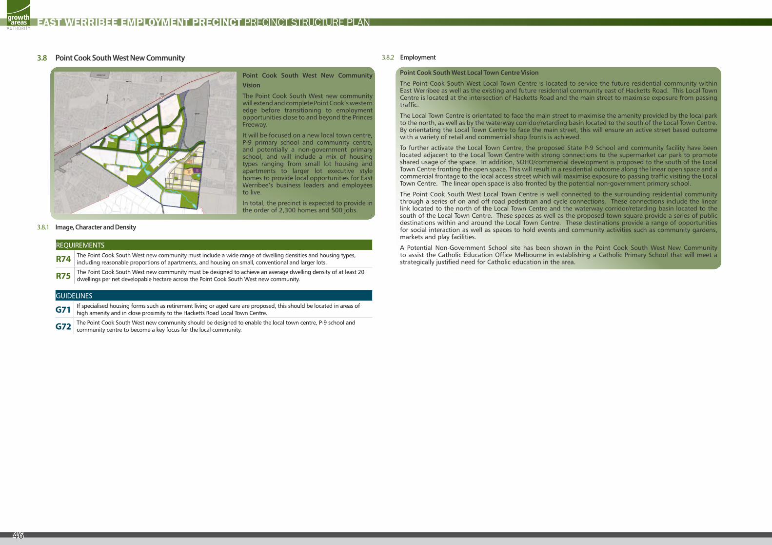
Point Cook South West New Community Vision
The Point Cook South West new community will extend and complete Point Cook’s western edge before transitioning to employment opportunities close to and beyond the Princes Freeway.
It will be focused on a new local town centre, P-9 primary school and community centre, and potentially a non-government primary school, and will include a mix of housing types ranging from small lot housing and apartments to larger lot executive style homes to provide local opportunities for East Werribee’s business leaders and employees to live.
In total, the precinct is expected to provide in the order of 2,300 homes and 500 jobs.
3.8.1 Image, Character and Density
REQUIREMENTS
R74 The Point Cook South West new community must include a wide range of dwelling densities and housing types, including reasonable proportions of apartments, and housing on small, conventional and larger lots.
R75 The Point Cook South West new community must be designed to achieve an average dwelling density of at least 20 dwellings per net developable hectare across the Point Cook South West new community.
GUIDELINES
G71 If specialised housing forms such as retirement living or aged care are proposed, this should be located in areas of high amenity and in close proximity to the Hacketts Road Local Town Centre.
G72 The Point Cook South West new community should be designed to enable the local town centre, P-9 school and community centre to become a key focus for the local community.
3.8.2 Employment
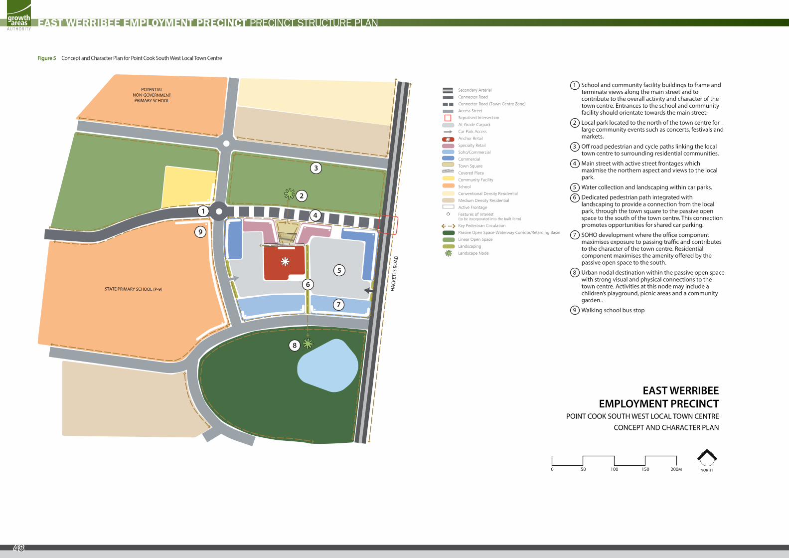
Point Cook South West Local Town Centre Vision
The Point Cook South West Local Town Centre is located to service the future residential community within East Werribee as well as the existing and future residential community east of Hacketts Road. This Local Town Centre is located at the intersection of Hacketts Road and the main street to maximise exposure from passing traffic.
The Local Town Centre is orientated to face the main street to maximise the amenity provided by the local park to the north, as well as by the waterway corridor/retarding basin located to the south of the Local Town Centre. By orientating the Local Town Centre to face the main street, this will ensure an active street based outcome with a variety of retail and commercial shop fronts is achieved.
To further activate the Local Town Centre, the proposed State P-9 School and community facility have been located adjacent to the Local Town Centre with strong connections to the supermarket car park to promote shared usage of the space. In addition, SOHO/commercial development is proposed to the south of the Local Town Centre fronting the open space. This will result in a residential outcome along the linear open space and a commercial frontage to the local access street which will maximise exposure to passing traffic visiting the Local Town Centre. The linear open space is also fronted by the potential non-government primary school.
The Point Cook South West Local Town Centre is well connected to the surrounding residential community through a series of on and off road pedestrian and cycle connections. These connections include the linear link located to the north of the Local Town Centre and the waterway corridor/retarding basin located to the south of the Local Town Centre. These spaces as well as the proposed town square provide a series of public destinations within and around the Local Town Centre. These destinations provide a range of opportunities for social interaction as well as spaces to hold events and community activities such as community gardens, markets and play facilities.
A Potential Non-Government School site has been shown in the Point Cook South West New Community to assist the Catholic Education Office Melbourne in establishing a Catholic Primary School that will meet a strategically justified need for Catholic education in the area.
47
EAST WERRIBEE EMPLOYMENT PRECINCT PRECINCT STRUCTURE PLAN
REQUIREMENTS
R76
Land use and development must be generally in accordance with the Point Cook South West Local Town Centre Concept and Character Plan shown in Figure 5 and as follows:
• A supermarket and supporting specialty stores;
• Cafe, restaurant and take-away premises;
• Commercial uses which could include office, medical, childcare, service providers and SOHO (small office home office) uses;
• State P-9 School;
• Community facility;
• Town square;
• Car parking; and
• Medium and high density housing.
R77 Land use and development must respond to the Local Town Centre Design Guidelines in Appendix 4.2.
R78 The supermarket or anchor retailer must be directly accessed from the Connector Street or from the town square.
R79 The Local Town Centre design must include provision for commercial uses including offices.
R80
The design of the Local Town Centre must respond to the key view lines around and through the town centre including:
• The view line along the main street from Hacketts Road and the treatment of the Hacketts Road and main street intersection;
• The treatment of the facades of the community facility and proposed state primary school terminating the view line along the main street;
• The facades of the commercial uses fronting Hacketts Road; and
• The treatment of the landscape nodes within the waterway corridor/retarding basin as nominated on the Local Town Centre Concept and Character plan shown.
R81 Ensure sites on street corners present active built form to the corner site boundary.
R82 Building facades on side streets and continuous walls must not exceed 10 meters without articulation, fenestration, activity or visual interest.
R83
Key locations within the Local Town Centre must incorporate features of interest into the built form and surrounding landscape (refer to Figure 5: Point Cook South West Local Town Centre Concept and Character Plan). Features of interest include:
• Two storey construction or elements of two storey construction (such as higher floor to ceiling heights, parapets, awnings, shade structures or roof elements);
• Sculptured facades which include recesses and projections to provide variation and segmentation to the building facade;
• Strong vertical elements;
• Balconies;
• Roof and/or wall articulation; and/or
• Feature colours and materials that are sympathetic to the site’s surrounds.
R84
Buildings within the Local Town Centre must:
• Provide primary access for retail tenancies from either the main street or town square;
• Provide primary access to commercial or SOHO/commercial premises from the street frontages rather than from car parks;
• Be built to the street front. Where buildings are set back from the street front, the frontage of the building must be active and must be designed in a way which contributes to the public domain; and
• Locate car parking and service infrastructure to the rear or side of the main street or town square frontage.
R85 Provide direct walking and cycling connections between the retail core, the town square, the waterway corridor/retarding basin, linear open space, community facility and state primary school.
R86 The final configuration of the town square must consider passive surveillance opportunities, key pedestrian circulation and design outcomes which create an attractive destination and supports a range of uses. The minimum area of the town square must not be less than 500 sq m.
GUIDELINES
G73 Refer to Figure 5 Point Cook South West Local Town Centre Concept and Character Plan for potential activities, events and treatments of the Local Town Centre.
G74 Footpaths in the main street should be a minimum width of 4.0 metres.
G75 Large expanses of blank walls along streets should be avoided. Blank walls must be treated to discourage graffiti.
G76 Encourage and provide opportunities for home based businesses throughout the precinct, particularly in close proximity to town centres.
48
EAST WERRIBEE EMPLOYMENT PRECINCT PRECINCT STRUCTURE PLAN
Figure 5 Concept and Character Plan for Point Cook South West Local Town Centre
STATE PRIMARY SCHOOL (P-9)
POTENTIALNON-GOVERNMENTPRIMARY SCHOOL
HA
CKET
TS R
OA
D
Secondary Arterial
Connector Road
Connector Road (Town Centre Zone)
Access Street
Signalised Intersection
At-Grade Carpark
Car Park Access
Anchor Retail
Specialty Retail
Soho/Commercial
Commercial
Town Square
Covered Plaza
Community Facility
School
Conventional Density Residential
Medium Density Residential
Active Frontage
Features of Interest(to be incorporated into the built form)
Key Pedestrian Circulation
Passive Open Space-Waterway Corridor/Retarding Basin
Linear Open Space
Landscaping
Landscape Node
NORTH
EAST WERRIBEEEMPLOYMENT PRECINCT
POINT COOK SOUTH WEST LOCAL TOWN CENTRECONCEPT AND CHARACTER PLAN
0 50 100 150 200M
1
2
3
4
6
7
8
9
5
1 School and community facility buildings to frame and terminate views along the main street and to contribute to the overall activity and character of the town centre. Entrances to the school and community facility should orientate towards the main street.
2 Local park located to the north of the town centre for large community events such as concerts, festivals and markets.
3 O� road pedestrian and cycle paths linking the local town centre to surrounding residential communities.
4 Main street with active street frontages which maximise the northern aspect and views to the local park.
5 Water collection and landscaping within car parks.
6 Dedicated pedestrian path integrated with landscaping to provide a connection from the local park, through the town square to the passive open space to the south of the town centre. This connection promotes opportunities for shared car parking.
7 SOHO development where the o�ce component maximises exposure to passing tra�c and contributes to the character of the town centre. Residential component maximises the amenity o�ered by the passive open space to the south.
8 Urban nodal destination within the passive open space with strong visual and physical connections to the town centre. Activities at this node may include a children’s playground, picnic areas and a community garden..
9 Walking school bus stop
49
EAST WERRIBEE EMPLOYMENT PRECINCT PRECINCT STRUCTURE PLAN
3.8.3 Transport
REQUIREMENTS
R87 A 3.0 metre wide shared path must be provided along the green space to the north of the Point Cook South West Local Town Centre and government P-9 school.
3.8.4 Community Facilities
REQUIREMENTS
R88 Space must be provided within the Point Cook South West Precinct to enable the provision of a Level 1 Early Years Centre (with 2 kindergarten rooms, a dual maternal and childhood health facility, specialist consulting rooms and playgroup space).
GUIDELINES
G77 Any private kindergartens should be integrated well with the Early Years Centre.
G78 Co-location of the Point Cook South West Early Years Centre with proposed children’s playgrounds, recreation infrastructure and kindergartens is encouraged.
G79 The Point Cook South West Early Years Centre should be located proximate to the Point Cook South West Local Town Centre.
G80 Where a Responsible Authority is satisfied that land shown as a non-government school site is unlikely to be used for a non-government school, that land may be used for an alternative purpose which is generally in accordance with the Precinct Structure Plan and consistent with the provisions of the applied zones.
PRINCES FREEWAY
PRINCES FREEWAY
MAL
TBY
BYPA
SS
MAL
TBY
BYPA
SS
WERRIBEECITY
CENTRE
HoppersCrossing
WERRIBEE PLAZA
SNEYDES ROAD
DER
RIM
UT
ROAD
MO
RRIS
RO
AD
HEATHS ROAD
HO
PPERS LAN
E
PRINCES HIGHWAY
POINT COOKWEST PSP
DUNNINGS ROAD
LAKESIDE AVENUE
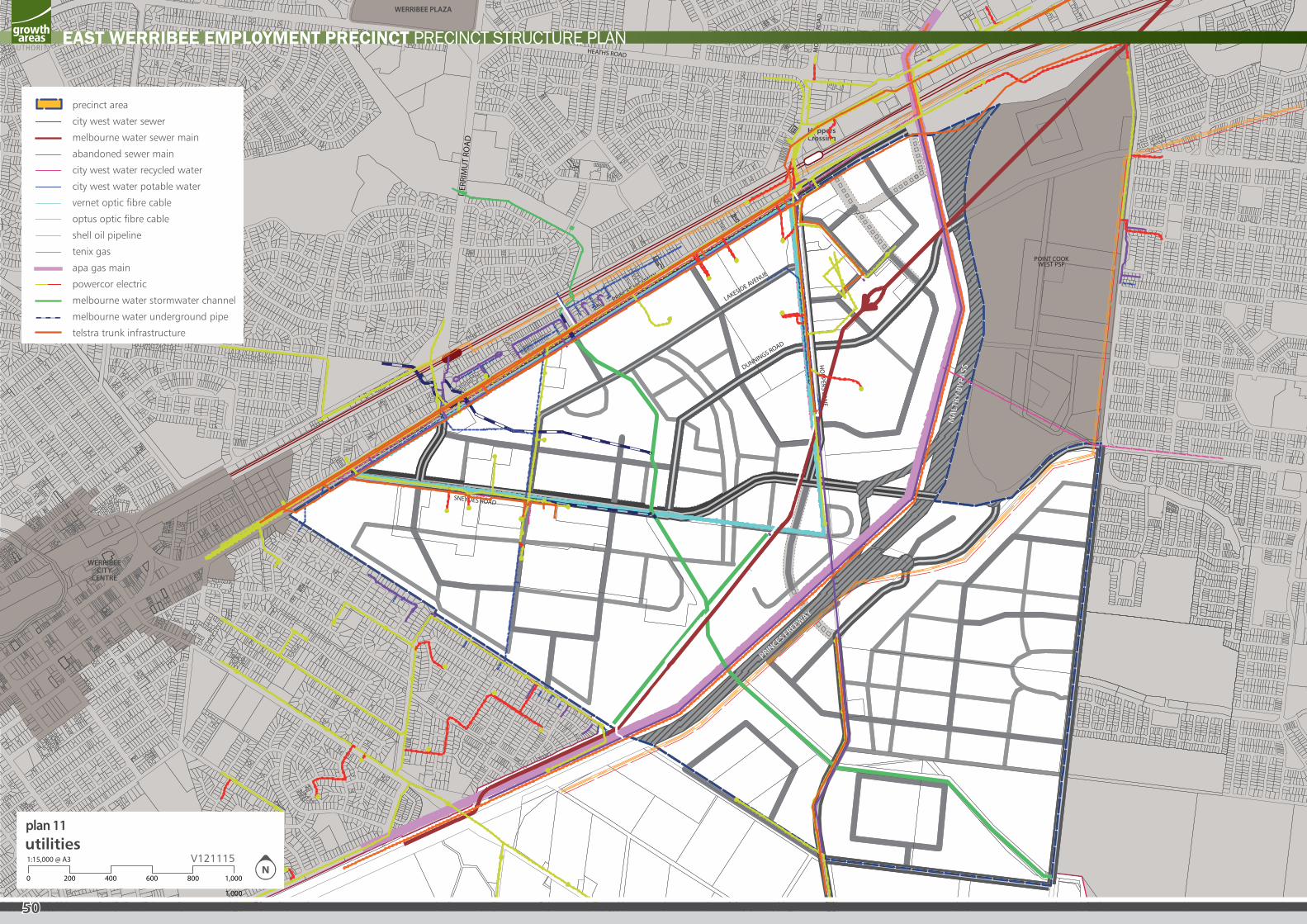
1,000
utilities1:15,000 @ A3
8006004002000 1,000
V121115
precinct area
city west water sewer
melbourne water sewer main
abandoned sewer main
city west water recycled water
city west water potable water
vernet optic fibre cable
optus optic fibre cable
shell oil pipeline
tenix gas
apa gas main
powercor electric
melbourne water stormwater channel
melbourne water underground pipe
telstra trunk infrastructure
plan 11
50
EAST WERRIBEE EMPLOYMENT PRECINCT PRECINCT STRUCTURE PLAN
51
EAST WERRIBEE EMPLOYMENT PRECINCT PRECINCT STRUCTURE PLAN
3.9 Servicing and Utilities
REQUIREMENTS
R89 Final design of constructed and modified waterways, retarding basins and wetlands must be approved by Melbourne Water.
R90 Stormwater drainage must be designed in accordance with any Development Services Scheme established by Melbourne Water. The current extent of retarding basins, wetlands and waterway corridors shown in this PSP are indicative only and the final size and alignment of the drainage system will need to be determined through further detailed investigation.
R91 Stormwater quality treatment must be to the satisfaction of the Responsible Authority and Melbourne Water. The treatment must consider Best Practice Environmental Management targets for discharge into waterways within any developed site and both distributed and end of pipe systems. Sediment must be removed prior to discharge to any waterway. (See Integrated Water Cycle Management targets)
R92 Development must conform to relevant policies and strategies being implemented by the Responsible Authority, Melbourne Water and the Water Retail Authority, including any approved Integrated Water Management Plan.
R93 All new electricity supply infrastructure (excluding substation and cables with a voltage greater than 66kV) must be provided underground.
R94 Any new zone substations must be identified at the subdivision design response stage to ensure effective integration with the surrounding land uses and to minimize amenity impacts.
R95 All businesses, organisations and dwellings must have access to broadband.
R96 Provision must be made for an APA Gasnet/SP Ausnet CityGate in close proximity to the existing high pressure gas main that runs along the western side of the historic sewer.
R97 Any part of a new building must not be located within 5 metres of the Melbourne Water trunk sewer. The “University Village” Concept and Character plan takes this into account.
R98 Vegetation proposed within 3 metres of the Melbourne Water trunk sewer must be to the satisfaction of Melbourne Water and meet the requirements of “Planting near Sewers, Drains and Water Mains Guide”.
R99 Vegetation proposed near the Shell WAG and BOPL Pipeline easement must not be planted closer than two-thirds of the mature height from the edge of the easement.
R100 The Stormwater Strategy for the precinct is based on the use of distributed water sensitive urban design treatment measures across a range of spatial scales including allotment, streetscapes, passive parks, neighbourhood and estates. Development cannot occur within the 1:100 year floodplain where there will be impacts to flood storage or conveyance. Any encroachment into the 1:100 year floodplain must be approved by Melbourne Water.
GUIDELINES
G81 Corridors and buffers along waterways should be managed to protect water quality and public health and safety.
G82 Integrated water cycle management systems should be designed to maximize habitat values for local flora and fauna species.
G83 Development should aim to maintain existing flow regimes (flow intensity, direction) at the pre-development level to the satisfaction of Melbourne Water.
G84 Electricity substations should be located outside of key view lines and screened with vegetation.
G85 The design of electricity infrastructure at the time of subdivision should consider the practicality of removing existing above ground electricity lines in the local and arterial road network both within and abutting the subdivision and re-routing lines underground through the subdivision.
G86
Staging will be determined largely by the development program of proponents within the precinct and the availability of infrastructure services. Within this context, the following should be achieved:
• Development staging should not create circumstances in which residents will be unreasonably isolated from community facilities or public transport;
• Development staging should, to the extent practicable, be integrated with adjoin developments, including the timely provision of connecting roads and walking/ cycling paths;
• Access to each new lot must be via a sealed road.
G87 The early delivery of active open space, community facilities, local parks and playgrounds should be encouraged within each neighbourhood and may be delivered in stages.
G88
The new zone substation required by PowerCor should be located within either the Enterprise precinct or the Interchange Business precincts. If an appropriate site cannot be found within the Enterprise or Business Interchange precincts, then the zone substation may be located between the Melbourne Water pumping station and the Maltby Bypass in the Health and Education precinct.
In all cases, the zone substation should be located on a non-prominent corner site.
G89 800m2 of land adjacent to the Melbourne Water Trunk Sewer, with road access, should be set aside to enable the provision of a sewage pump station.
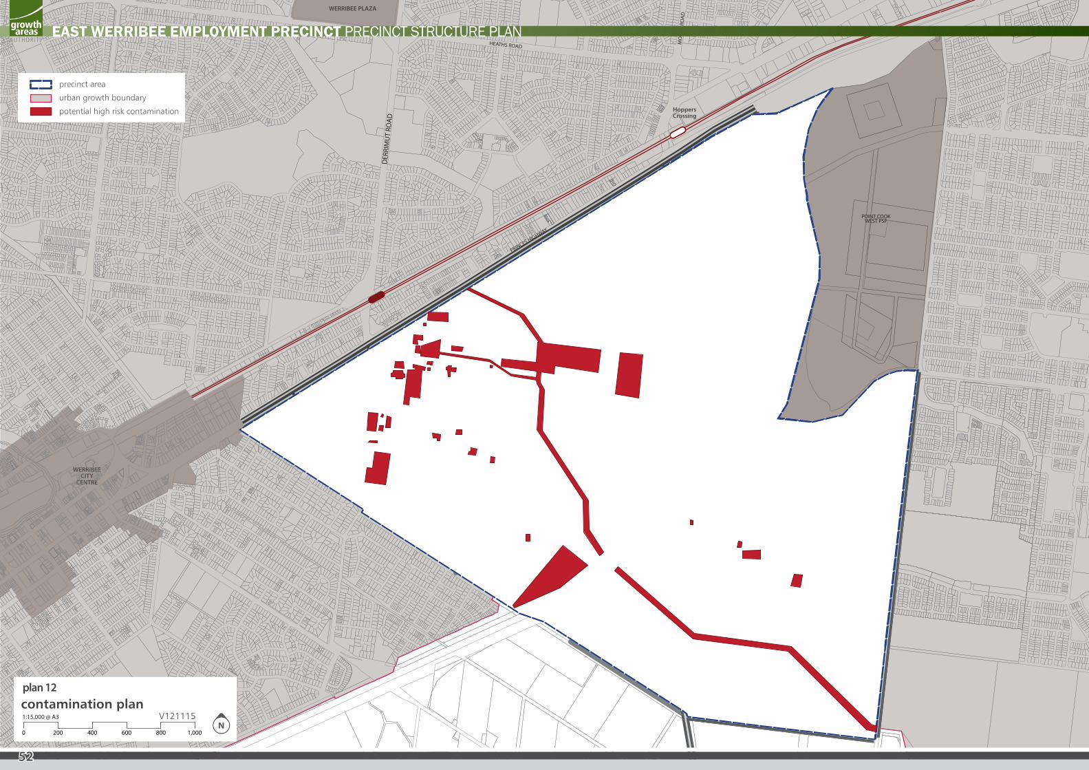
PRINCES FREEWAY
PRINCES FREEWAY
MAL
TBY
BYPA
SS
MAL
TBY
BYPA
SS
MercyHospital
Universityof
Melbourne
ProposedState
PrimarySchool
(P-6)
ProposedState
School(P-9)
PotentialNon-Gov.PrimarySchool
SuzanneCory School
WERRIBEECITY
CENTRE
HoppersCrossing
WERRIBEE PLAZA
MelbourneWater
PumpingStation
WyndhamSportingComplex
VictoriaUniversity
SNEYDES ROAD
DER
RIM
UT
ROAD
MO
RRIS
RO
AD
HEATHS ROAD
HO
PPERS LAN
E
PRINCES HIGHWAY
HeritageArea East Werribee
Town Centre
LocalTown
Centre
LocalTown
Centre
Hoppers CrossingTown Centre
Transition
LocalTown
Centre
POINT COOKWEST PSP
DUNNINGS ROAD
LAKESIDE AVENUE
precinct area
city west water sewer
melbourne water sewer main
abandoned sewer main
city west water recycled water
city west water potable water
vernet optic fibre cable
optus optic fibre cable
shell oil pipeline
tenix gas
apa gas main
powercor electric
melbourne water stormwater channel
melbourne water underground pipe
sneydes road retetion basin
telstra trunk infrastructure
precinct area
urban growth boundary
potential high risk contamination
contamination plan1:15,000 @ A3
8006004002000 1,000
V121115
plan 12
52
EAST WERRIBEE EMPLOYMENT PRECINCT PRECINCT STRUCTURE PLAN
53
EAST WERRIBEE EMPLOYMENT PRECINCT PRECINCT STRUCTURE PLAN
3.10 ContaminationAs a result of the site’s former use as a State Research Farm, limited parts of the site may to be subject to contamination.
Studies conducted by Compass Environmental for VicUrban in 2009 and by Coffey for DPCD in 2010 indicated the level of risk across the site, including a number of high risk areas and point sources. The reports recommend a Phase 2 Environmental Assessment. (See GAA website for more details)
The planning provisions alongside this Precinct Structure Plan set out requirements for a Phase 2 Environmental Assessment for sensitive uses proposed anywhere in the precinct.
3.11 Precinct InfrastructureThe Precinct Infrastructure Table at Table 4 below sets out the infrastructure and services required to meet the needs of development of the precinct. The infrastructure items and services are to be provided through a number of mechanisms including:
• Subdivision construction works by developers;
• Agreements under Section 173 of the Act;
• Utility service provider requirements; and
• Capital works projects by Council, State government agencies and non-government organizations.
REQUIREMENTS
R101
As part of subdivision construction works, new development must provide and meet the total cost of delivering the following infrastructure:
• All shared paths shown on Plan 10 – Public and Active Transport Plan
• Connector roads and local streets.
• Local bus stop infrastructure.
• Landscaping of all existing and future roads and local streets.
• Intersection works and traffic management measures along arterial roads, connector streets, and local streets.
• Council approved fencing and landscaping (where required) along arterial roads.
• Pedestrian and bicycle paths along local arterial roads, connector roads and local streets and within local parks (except those included in the Development Contributions Plan).
• Bicycle parking facilities in convenient locations at key destinations such as parks and activity centres.
• Basic improvements to local parks / open space including leveling, grassing, tree planting and local paths consistent with the Councils required construction standards.
• Local drainage systems and associated pedestrian bridges.
• Infrastructure as required by utility services providers including water, sewerage, drainage (except where the item is funded through a Development Services Scheme), electricity, gas, and telecommunications.
R102 The detailed land budget included in Section 2.3 clearly sets out the NDA for every property included in the PSP. The NDA will not be amended to respond to minor changes to land budgets that may result from the subdivision process unless the Responsible Authority agrees to a variation.
R103
All parks (where not otherwise provided via a Development Contributions Plan) must be finished to the standard to the satisfaction of the Responsible Authority prior to the transfer of the space to Council, including:
• Removal of all existing disused structures, foundations, pipelines or stockpiles.
• Cleared of rubbish and environmental weeds, levelled, topsoiled and grassed with warm climate grass (unless conservation reserve requirements dictate otherwise).
• Provision of water tapping, potable and recycled water connection points. Sewer and gas connection points must also be provided to land identified as an active reserve,
• Drought resistant plantings.
• Vehicles exclusion devices (fence, bollards or other suitable method) and maintenance access points.
• Construction of a 2.5 metre shared path (concrete unless otherwise approved by the responsible authority) around the perimeter of the reserve, connecting and linking into any other surrounding paths or points of interest, and
• Installation of park furniture including BBQs, shelters, tables, local scale playgrounds and other local scale play elements such as ½ basketball courts and hit-up walls, rubbish bins and appropriate paving to support these facilities.
• For town squares and urban spaces – paving and planters, furniture including seating, shelters and bollards, tree and other planting, lighting, drainage and water tapping.
Parkland that is provided via a Developer Contributions Plan (and where future DCP construction works will be carried out by Council) must be finished to a ‘fit for purpose’ condition, prior to handover to Council, as follows:
• Removal of surface / protruding rocks.
• Basic grading and / or topsoiling to create a safe and regular surface suitable for public use and maintenance (maximum 1:6 gradient).
• Seeding, top-dressing of drought resistant grass to bare, patchy and newly graded areas.
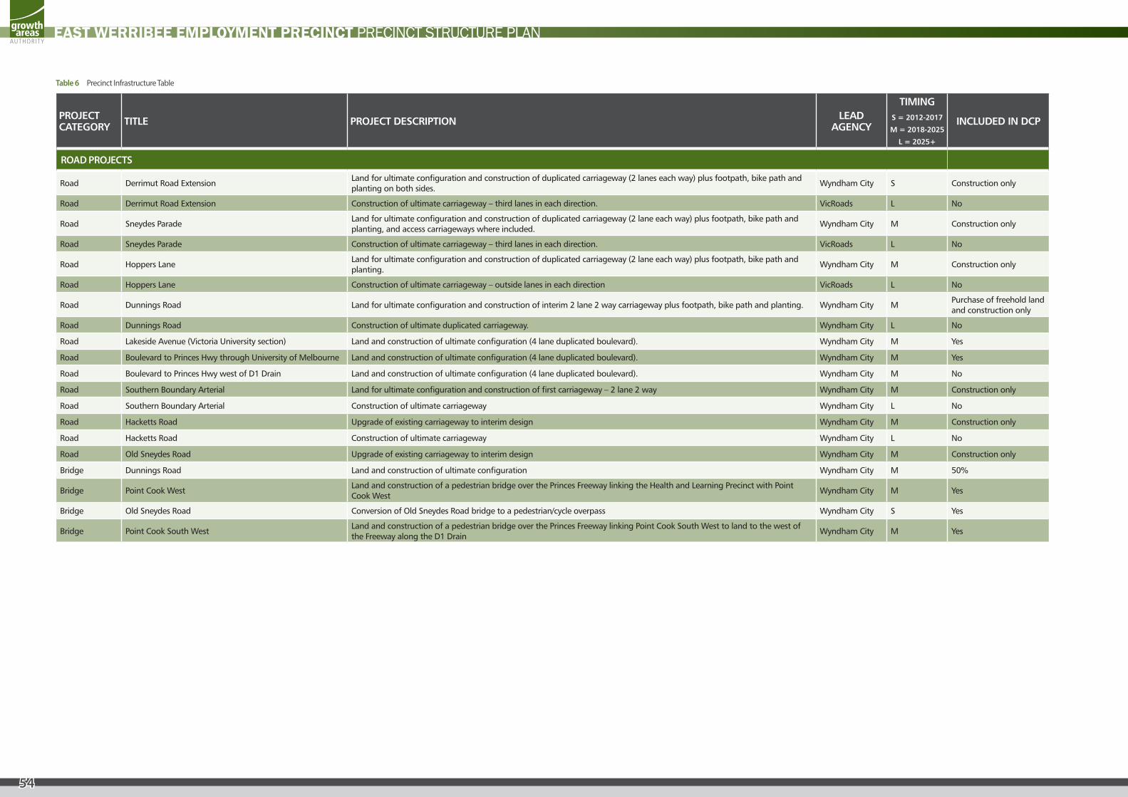
54
EAST WERRIBEE EMPLOYMENT PRECINCT PRECINCT STRUCTURE PLAN
PROJECT CATEGORY TITLE PROJECT DESCRIPTION LEAD
AGENCY
TIMINGS = 2012-2017
M = 2018-2025
L = 2025+
INCLUDED IN DCP
ROAD PROJECTS
Road Derrimut Road ExtensionLand for ultimate configuration and construction of duplicated carriageway (2 lanes each way) plus footpath, bike path and planting on both sides.
Wyndham City S Construction only
Road Derrimut Road Extension Construction of ultimate carriageway – third lanes in each direction. VicRoads L No
Road Sneydes ParadeLand for ultimate configuration and construction of duplicated carriageway (2 lane each way) plus footpath, bike path and planting, and access carriageways where included.
Wyndham City M Construction only
Road Sneydes Parade Construction of ultimate carriageway – third lanes in each direction. VicRoads L No
Road Hoppers LaneLand for ultimate configuration and construction of duplicated carriageway (2 lane each way) plus footpath, bike path and planting.
Wyndham City M Construction only
Road Hoppers Lane Construction of ultimate carriageway – outside lanes in each direction VicRoads L No
Road Dunnings Road Land for ultimate configuration and construction of interim 2 lane 2 way carriageway plus footpath, bike path and planting. Wyndham City MPurchase of freehold land and construction only
Road Dunnings Road Construction of ultimate duplicated carriageway. Wyndham City L No
Road Lakeside Avenue (Victoria University section) Land and construction of ultimate configuration (4 lane duplicated boulevard). Wyndham City M Yes
Road Boulevard to Princes Hwy through University of Melbourne Land and construction of ultimate configuration (4 lane duplicated boulevard). Wyndham City M Yes
Road Boulevard to Princes Hwy west of D1 Drain Land and construction of ultimate configuration (4 lane duplicated boulevard). Wyndham City M No
Road Southern Boundary Arterial Land for ultimate configuration and construction of first carriageway – 2 lane 2 way Wyndham City M Construction only
Road Southern Boundary Arterial Construction of ultimate carriageway Wyndham City L No
Road Hacketts Road Upgrade of existing carriageway to interim design Wyndham City M Construction only
Road Hacketts Road Construction of ultimate carriageway Wyndham City L No
Road Old Sneydes Road Upgrade of existing carriageway to interim design Wyndham City M Construction only
Bridge Dunnings Road Land and construction of ultimate configuration Wyndham City M 50%
Bridge Point Cook WestLand and construction of a pedestrian bridge over the Princes Freeway linking the Health and Learning Precinct with Point Cook West
Wyndham City M Yes
Bridge Old Sneydes Road Conversion of Old Sneydes Road bridge to a pedestrian/cycle overpass Wyndham City S Yes
Bridge Point Cook South WestLand and construction of a pedestrian bridge over the Princes Freeway linking Point Cook South West to land to the west of the Freeway along the D1 Drain
Wyndham City M Yes
Table 6 Precinct Infrastructure Table
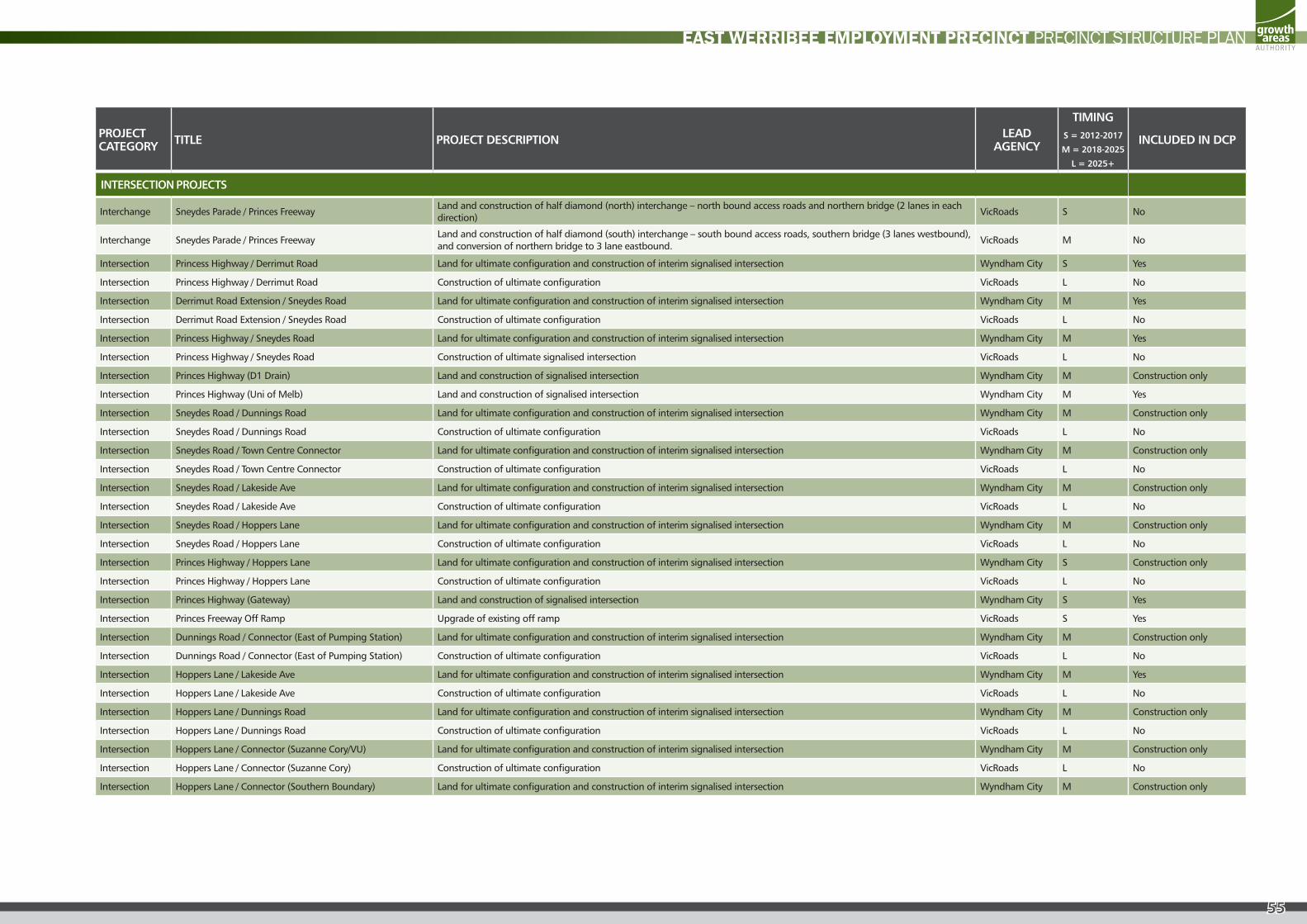
55
EAST WERRIBEE EMPLOYMENT PRECINCT PRECINCT STRUCTURE PLAN
PROJECT CATEGORY TITLE PROJECT DESCRIPTION LEAD
AGENCY
TIMINGS = 2012-2017
M = 2018-2025
L = 2025+
INCLUDED IN DCP
INTERSECTION PROJECTS
Interchange Sneydes Parade / Princes FreewayLand and construction of half diamond (north) interchange – north bound access roads and northern bridge (2 lanes in each direction)
VicRoads S No
Interchange Sneydes Parade / Princes FreewayLand and construction of half diamond (south) interchange – south bound access roads, southern bridge (3 lanes westbound), and conversion of northern bridge to 3 lane eastbound.
VicRoads M No
Intersection Princess Highway / Derrimut Road Land for ultimate configuration and construction of interim signalised intersection Wyndham City S Yes
Intersection Princess Highway / Derrimut Road Construction of ultimate configuration VicRoads L No
Intersection Derrimut Road Extension / Sneydes Road Land for ultimate configuration and construction of interim signalised intersection Wyndham City M Yes
Intersection Derrimut Road Extension / Sneydes Road Construction of ultimate configuration VicRoads L No
Intersection Princess Highway / Sneydes Road Land for ultimate configuration and construction of interim signalised intersection Wyndham City M Yes
Intersection Princess Highway / Sneydes Road Construction of ultimate signalised intersection VicRoads L No
Intersection Princes Highway (D1 Drain) Land and construction of signalised intersection Wyndham City M Construction only
Intersection Princes Highway (Uni of Melb) Land and construction of signalised intersection Wyndham City M Yes
Intersection Sneydes Road / Dunnings Road Land for ultimate configuration and construction of interim signalised intersection Wyndham City M Construction only
Intersection Sneydes Road / Dunnings Road Construction of ultimate configuration VicRoads L No
Intersection Sneydes Road / Town Centre Connector Land for ultimate configuration and construction of interim signalised intersection Wyndham City M Construction only
Intersection Sneydes Road / Town Centre Connector Construction of ultimate configuration VicRoads L No
Intersection Sneydes Road / Lakeside Ave Land for ultimate configuration and construction of interim signalised intersection Wyndham City M Construction only
Intersection Sneydes Road / Lakeside Ave Construction of ultimate configuration VicRoads L No
Intersection Sneydes Road / Hoppers Lane Land for ultimate configuration and construction of interim signalised intersection Wyndham City M Construction only
Intersection Sneydes Road / Hoppers Lane Construction of ultimate configuration VicRoads L No
Intersection Princes Highway / Hoppers Lane Land for ultimate configuration and construction of interim signalised intersection Wyndham City S Construction only
Intersection Princes Highway / Hoppers Lane Construction of ultimate configuration VicRoads L No
Intersection Princes Highway (Gateway) Land and construction of signalised intersection Wyndham City S Yes
Intersection Princes Freeway Off Ramp Upgrade of existing off ramp VicRoads S Yes
Intersection Dunnings Road / Connector (East of Pumping Station) Land for ultimate configuration and construction of interim signalised intersection Wyndham City M Construction only
Intersection Dunnings Road / Connector (East of Pumping Station) Construction of ultimate configuration VicRoads L No
Intersection Hoppers Lane / Lakeside Ave Land for ultimate configuration and construction of interim signalised intersection Wyndham City M Yes
Intersection Hoppers Lane / Lakeside Ave Construction of ultimate configuration VicRoads L No
Intersection Hoppers Lane / Dunnings Road Land for ultimate configuration and construction of interim signalised intersection Wyndham City M Construction only
Intersection Hoppers Lane / Dunnings Road Construction of ultimate configuration VicRoads L No
Intersection Hoppers Lane / Connector (Suzanne Cory/VU) Land for ultimate configuration and construction of interim signalised intersection Wyndham City M Construction only
Intersection Hoppers Lane / Connector (Suzanne Cory) Construction of ultimate configuration VicRoads L No
Intersection Hoppers Lane / Connector (Southern Boundary) Land for ultimate configuration and construction of interim signalised intersection Wyndham City M Construction only
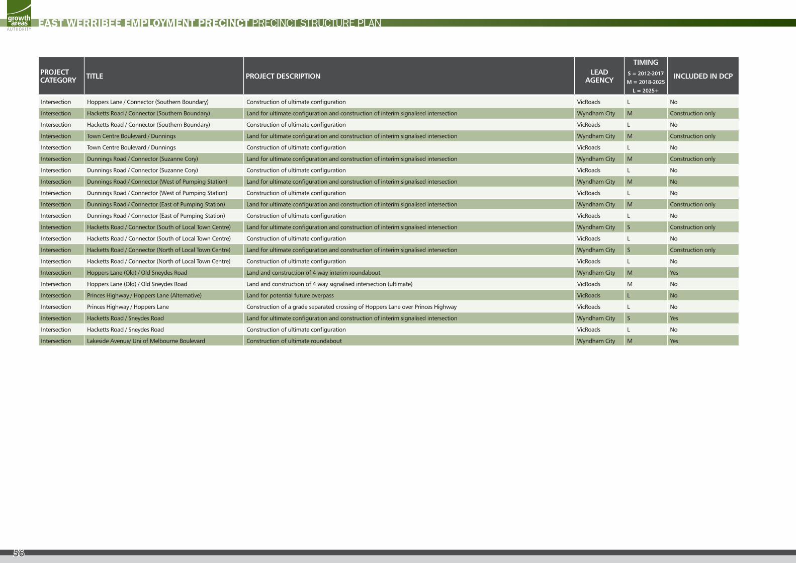
56
EAST WERRIBEE EMPLOYMENT PRECINCT PRECINCT STRUCTURE PLAN
PROJECT CATEGORY TITLE PROJECT DESCRIPTION LEAD
AGENCY
TIMINGS = 2012-2017
M = 2018-2025
L = 2025+
INCLUDED IN DCP
Intersection Hoppers Lane / Connector (Southern Boundary) Construction of ultimate configuration VicRoads L No
Intersection Hacketts Road / Connector (Southern Boundary) Land for ultimate configuration and construction of interim signalised intersection Wyndham City M Construction only
Intersection Hacketts Road / Connector (Southern Boundary) Construction of ultimate configuration VicRoads L No
Intersection Town Centre Boulevard / Dunnings Land for ultimate configuration and construction of interim signalised intersection Wyndham City M Construction only
Intersection Town Centre Boulevard / Dunnings Construction of ultimate configuration VicRoads L No
Intersection Dunnings Road / Connector (Suzanne Cory) Land for ultimate configuration and construction of interim signalised intersection Wyndham City M Construction only
Intersection Dunnings Road / Connector (Suzanne Cory) Construction of ultimate configuration VicRoads L No
Intersection Dunnings Road / Connector (West of Pumping Station) Land for ultimate configuration and construction of interim signalised intersection Wyndham City M No
Intersection Dunnings Road / Connector (West of Pumping Station) Construction of ultimate configuration VicRoads L No
Intersection Dunnings Road / Connector (East of Pumping Station) Land for ultimate configuration and construction of interim signalised intersection Wyndham City M Construction only
Intersection Dunnings Road / Connector (East of Pumping Station) Construction of ultimate configuration VicRoads L No
Intersection Hacketts Road / Connector (South of Local Town Centre) Land for ultimate configuration and construction of interim signalised intersection Wyndham City S Construction only
Intersection Hacketts Road / Connector (South of Local Town Centre) Construction of ultimate configuration VicRoads L No
Intersection Hacketts Road / Connector (North of Local Town Centre) Land for ultimate configuration and construction of interim signalised intersection Wyndham City S Construction only
Intersection Hacketts Road / Connector (North of Local Town Centre) Construction of ultimate configuration VicRoads L No
Intersection Hoppers Lane (Old) / Old Sneydes Road Land and construction of 4 way interim roundabout Wyndham City M Yes
Intersection Hoppers Lane (Old) / Old Sneydes Road Land and construction of 4 way signalised intersection (ultimate) VicRoads M No
Intersection Princes Highway / Hoppers Lane (Alternative) Land for potential future overpass VicRoads L No
Intersection Princes Highway / Hoppers Lane Construction of a grade separated crossing of Hoppers Lane over Princes Highway VicRoads L No
Intersection Hacketts Road / Sneydes Road Land for ultimate configuration and construction of interim signalised intersection Wyndham City S Yes
Intersection Hacketts Road / Sneydes Road Construction of ultimate configuration VicRoads L No
Intersection Lakeside Avenue/ Uni of Melbourne Boulevard Construction of ultimate roundabout Wyndham City M Yes
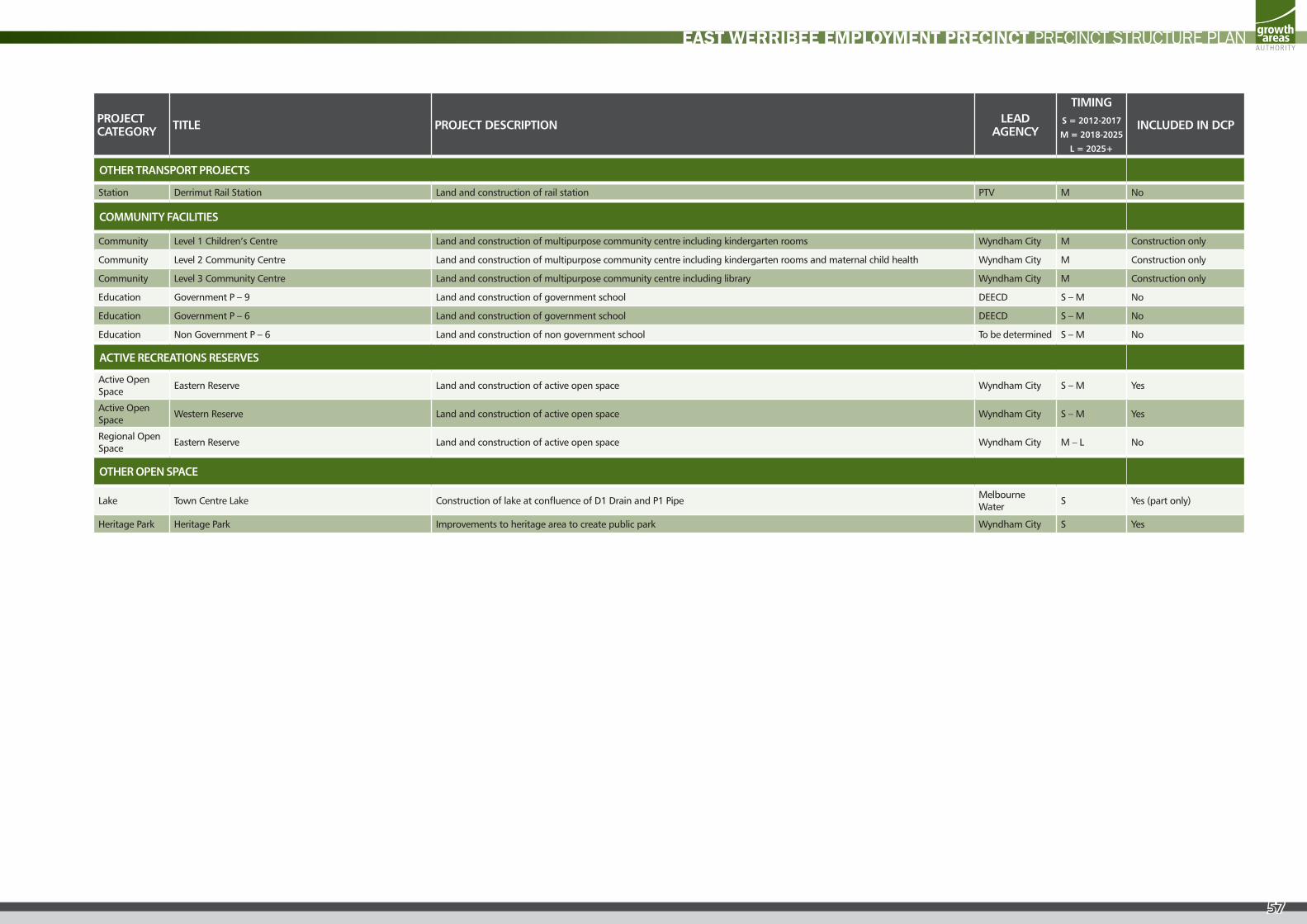
57
EAST WERRIBEE EMPLOYMENT PRECINCT PRECINCT STRUCTURE PLAN
PROJECT CATEGORY TITLE PROJECT DESCRIPTION LEAD
AGENCY
TIMINGS = 2012-2017
M = 2018-2025
L = 2025+
INCLUDED IN DCP
OTHER TRANSPORT PROJECTS
Station Derrimut Rail Station Land and construction of rail station PTV M No
COMMUNITY FACILITIES
Community Level 1 Children’s Centre Land and construction of multipurpose community centre including kindergarten rooms Wyndham City M Construction only
Community Level 2 Community Centre Land and construction of multipurpose community centre including kindergarten rooms and maternal child health Wyndham City M Construction only
Community Level 3 Community Centre Land and construction of multipurpose community centre including library Wyndham City M Construction only
Education Government P – 9 Land and construction of government school DEECD S – M No
Education Government P – 6 Land and construction of government school DEECD S – M No
Education Non Government P – 6 Land and construction of non government school To be determined S – M No
ACTIVE RECREATIONS RESERVES
Active Open Space
Eastern Reserve Land and construction of active open space Wyndham City S – M Yes
Active Open Space
Western Reserve Land and construction of active open space Wyndham City S – M Yes
Regional Open Space
Eastern Reserve Land and construction of active open space Wyndham City M – L No
OTHER OPEN SPACE
Lake Town Centre Lake Construction of lake at confluence of D1 Drain and P1 PipeMelbourne Water
S Yes (part only)
Heritage Park Heritage Park Improvements to heritage area to create public park Wyndham City S Yes