hap program update in japan- - capanina · collapse of elevated highway by hanshin earthquake ......
TRANSCRIPT
1
1
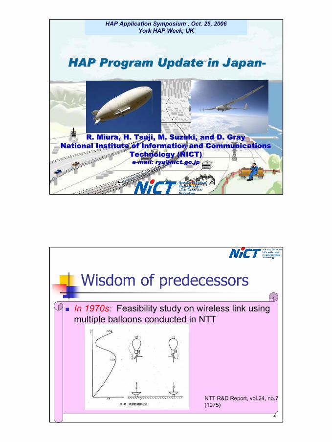
HAP Application Symposium , Oct. 25, 2006York HAP Week, UK
R. Miura, H. Tsuji, M. Suzuki, and D. GrayR. Miura, H. Tsuji, M. Suzuki, and D. GrayNational Institute of Information and Communications National Institute of Information and Communications
Technology (NICT)Technology (NICT)ee--mail: mail: [email protected]@nict.go.jp
HAP Program Update in JapanHAP Program Update in Japan--
2
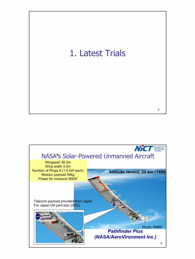
Wisdom of predecessors
In 1970s: Feasibility study on wireless link using multiple balloons conducted in NTT
NTT R&D Report, vol.24, no.7(1975)
2
3
1. Latest Trials
4
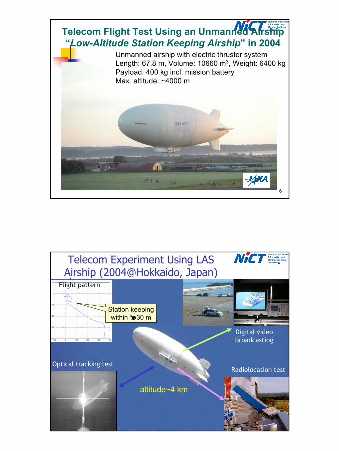
NASA’s Solar-Powered Unmanned Aircraft
Pathfinder Plus (NASA/AeroVironment Inc.)
Wingspan 36.3mWing width 3.4m
Number of Props 8 (1.5 kW each)Mission payload 50kg
Power for missions 600W
Altitude record: 24 km (1998)
Photo: PMRF
Telecom payload provided from JapanFor Japan-US joint trial (2002)
3
6
Telecom Flight Test Using an Unmanned Airship “Low-Altitude Station Keeping Airship” in 2004
Unmanned airship with electric thruster systemLength: 67.8 m, Volume: 10660 m3, Weight: 6400 kgPayload: 400 kg incl. mission batteryMax. altitude: ~4000 m
7
Telecom Experiment Using LAS Airship (2004@Hokkaido, Japan)
altitude~4 km
Optical tracking testRadiolocation test
Station keeping within 30 m
Flight pattern
Digital video broadcasting
4
8
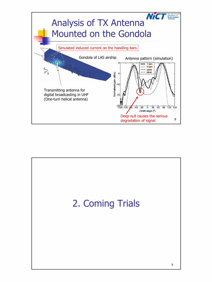
Analysis of TX Antenna Mounted on the Gondola
Simulated induced current on the handling bars
Deep null causes the serious degradation of signal
Transmitting antenna for digital broadcasting in UHF(One-turn helical antenna)
Gondola of LAS airship Antenna pattern (simulation)
9
2. Coming Trials
5
10
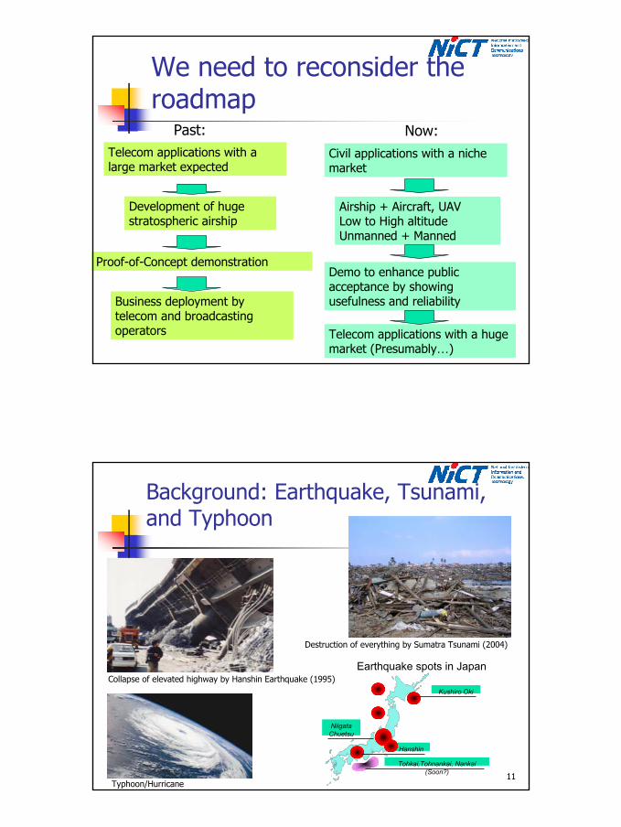
We need to reconsider the roadmap
Past:Telecom applications with a large market expected
Development of huge stratospheric airship
Business deployment by telecom and broadcasting operators
Now:Civil applications with a niche market
Proof-of-Concept demonstration
Airship + Aircraft, UAVLow to High altitudeUnmanned + Manned
Demo to enhance public acceptance by showing usefulness and reliability
Telecom applications with a huge market (Presumably…)
11
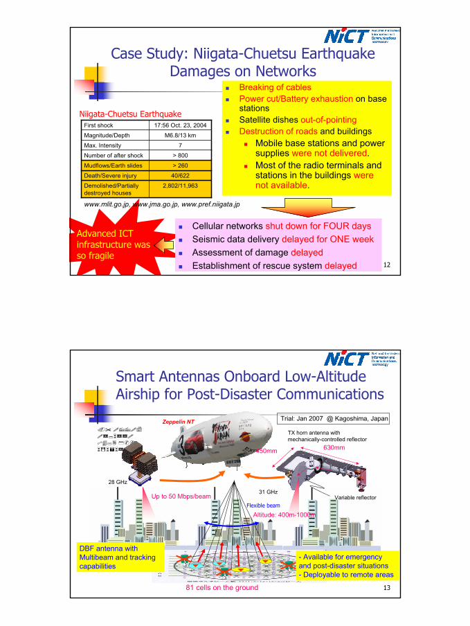
Background: Earthquake, Tsunami, and Typhoon
Niigata Chuetsu
Hanshin
Tohkai,Tohnankai, Nankai(Soon?)
Kushiro Oki
Earthquake spots in JapanCollapse of elevated highway by Hanshin Earthquake (1995)
Typhoon/Hurricane
Destruction of everything by Sumatra Tsunami (2004)
6
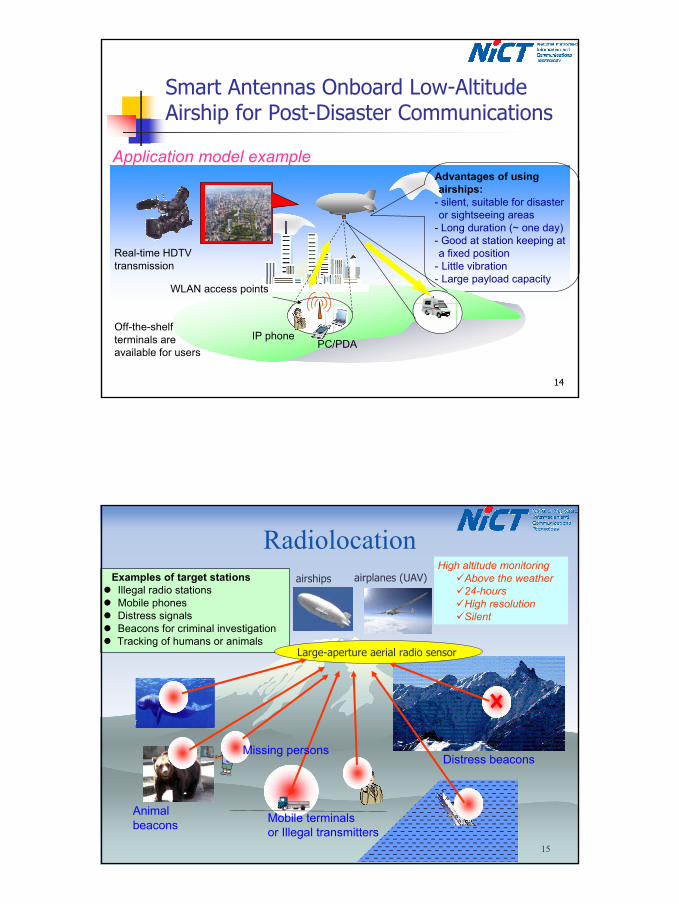
12
Advanced ICT infrastructure was so fragile
Case Study: Niigata-Chuetsu EarthquakeDamages on Networks
Breaking of cablesPower cut/Battery exhaustion on base stationsSatellite dishes out-of-pointingDestruction of roads and buildings
Mobile base stations and power supplies were not delivered.Most of the radio terminals and stations in the buildings were not available.
Cellular networks shut down for FOUR daysSeismic data delivery delayed for ONE weekAssessment of damage delayedEstablishment of rescue system delayed
> 260Mudflows/Earth slides
40/622Death/Severe injury
> 800Number of after shock
2,802/11,963Demolished/Partially destroyed houses
7Max. Intensity
M6.8/13 kmMagnitude/Depth
17:56 Oct. 23, 2004First shock
Niigata-Chuetsu Earthquake
www.mlit.go.jp, www.jma.go.jp, www.pref.niigata.jp
13
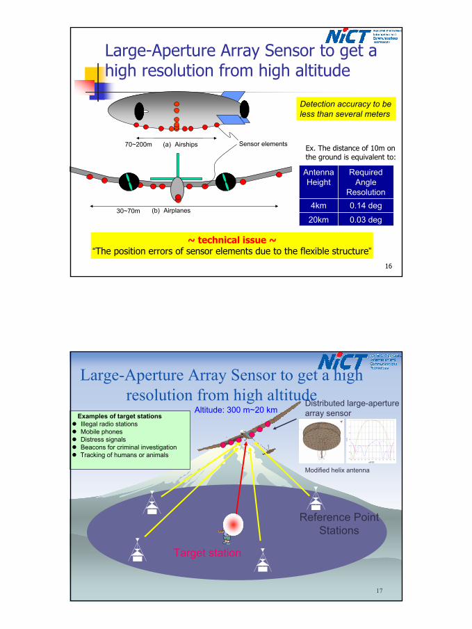
Smart Antennas Onboard Low-Altitude Airship for Post-Disaster Communications
Up to 50 Mbps/beam
28 GHz
Variable reflector
Zeppelin NT
31 GHz
630mm450mm
TX horn antenna with mechanically-controlled reflector
Altitude: 400m-1000mFlexible beam
- Available for emergency and post-disaster situations- Deployable to remote areas
DBF antenna with Multibeam and tracking capabilities
81 cells on the ground
Trial: Jan 2007 @ Kagoshima, Japan
7
14
Smart Antennas Onboard Low-Altitude Airship for Post-Disaster Communications
Advantages of using airships:
- silent, suitable for disaster or sightseeing areas
- Long duration (~ one day)- Good at station keeping at a fixed position
- Little vibration- Large payload capacity
Real-time HDTV transmission
WLAN access points
IP phonePC/PDA
Application model example
Off-the-shelf terminals are available for users
15
Radiolocation
Mobile terminalsor Illegal transmitters
Distress beacons
High altitude monitoringAbove the weather24-hoursHigh resolutionSilent
Animal beacons
Examples of target stationsIllegal radio stationsMobile phonesDistress signalsBeacons for criminal investigationTracking of humans or animals
Large-aperture aerial radio sensor
Missing persons
airships airplanes (UAV)
8
16
Large-Aperture Array Sensor to get a high resolution from high altitude
~ technical issue ~“The position errors of sensor elements due to the flexible structure”
70~200m
30~70m
(a) Airships
(b) Airplanes
Sensor elements
Detection accuracy to be less than several meters
0.03 deg20km
0.14 deg4km
Required Angle
Resolution
Antenna Height
Ex. The distance of 10m on the ground is equivalent to:
17
Large-Aperture Array Sensor to get a high resolution from high altitude
Reference PointStations
Target station
Distributed large-aperture array sensor Examples of target stations
Illegal radio stationsMobile phonesDistress signalsBeacons for criminal investigationTracking of humans or animals
Altitude: 300 m~20 km
Modified helix antenna
9
18
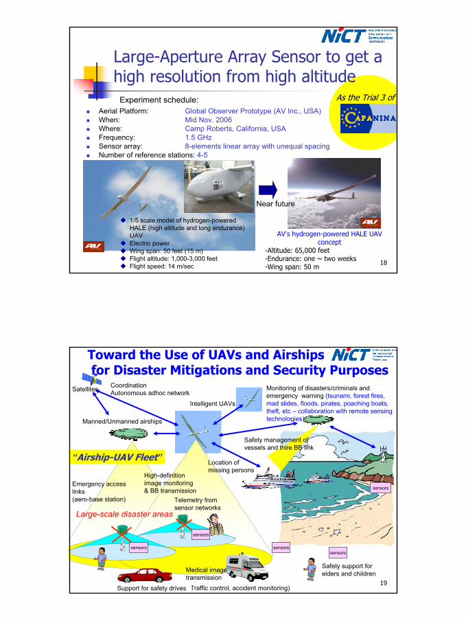
Large-Aperture Array Sensor to get a high resolution from high altitude
Aerial Platform: Global Observer Prototype (AV Inc., USA)When: Mid Nov. 2006Where: Camp Roberts, California, USAFrequency: 1.5 GHzSensor array: 8-elements linear array with unequal spacingNumber of reference stations: 4-5
1/5 scale model of hydrogen-powered HALE (high altitude and long endurance) UAVElectric powerWing span: 50 feet (15 m)Flight altitude: 1,000-3,000 feetFlight speed: 14 m/sec
AV’s hydrogen-powered HALE UAV concept
-Altitude: 65,000 feet-Endurance: one ~ two weeks-Wing span: 50 m
Experiment schedule:
Near future
As the Trial 3 of
19
Monitoring of disasters/criminals and emergency warning (tsunami, forest fires, mad slides, floods, pirates, poaching boats, theft, etc – collaboration with remote sensing technologies)
Toward the Use of UAVs and Airshipsfor Disaster Mitigations and Security Purposes
sensors
sensors
sensorssensorssensors
Intelligent UAVs
Manned/Unmanned airships
Emergency access links(aero-base station)
High-definition image monitoring & BB transmission
Telemetry from sensor networks
Location of missing persons
Medical image transmission
Safety management of vessels and thire BB link
(Traffic control, accident monitoring)
Safety support for elders and children
Support for safety drives
CoordinationAutonomous adhoc networkSatellites
Large-scale disaster areas
“Airship-UAV Fleet”