habersham county board of commission executive summary · habersham county board of commission...
TRANSCRIPT
HABERSHAM COUNTY BOARD OF COMMISSION
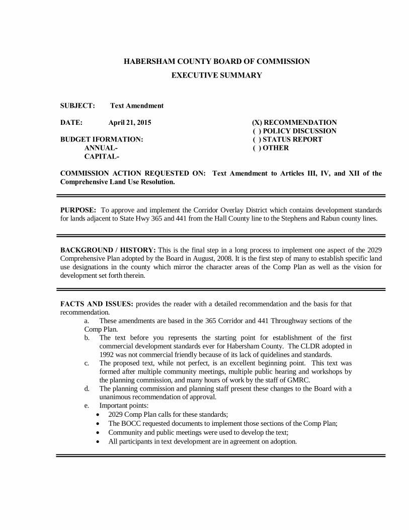
EXECUTIVE SUMMARY SUBJECT: Text Amendment DATE: April 21, 2015 (X) RECOMMENDATION ( ) POLICY DISCUSSION BUDGET IFORMATION: ( ) STATUS REPORT ANNUAL- ( ) OTHER CAPITAL- COMMISSION ACTION REQUESTED ON: Text Amendment to Articles III, IV, and XII of the Comprehensive Land Use Resolution.
PURPOSE: To approve and implement the Corridor Overlay District which contains development standards for lands adjacent to State Hwy 365 and 441 from the Hall County line to the Stephens and Rabun county lines.
BACKGROUND / HISTORY: This is the final step in a long process to implement one aspect of the 2029 Comprehensive Plan adopted by the Board in August, 2008. It is the first step of many to establish specific land use designations in the county which mirror the character areas of the Comp Plan as well as the vision for development set forth therein.
FACTS AND ISSUES: provides the reader with a detailed recommendation and the basis for that recommendation. a. These amendments are based in the 365 Corridor and 441 Throughway sections of the
Comp Plan. b. The text before you represents the starting point for establishment of the first
commercial development standards ever for Habersham County. The CLDR adopted in 1992 was not commercial friendly because of its lack of quidelines and standards.
c. The proposed text, while not perfect, is an excellent beginning point. This text was formed after multiple community meetings, multiple public hearing and workshops by the planning commission, and many hours of work by the staff of GMRC.
d. The planning commission and planning staff present these changes to the Board with a unanimous recommendation of approval.
e. Important points: • 2029 Comp Plan calls for these standards; • The BOCC requested documents to implement those sections of the Comp Plan; • Community and public meetings were used to develop the text; • All participants in text development are in agreement on adoption.
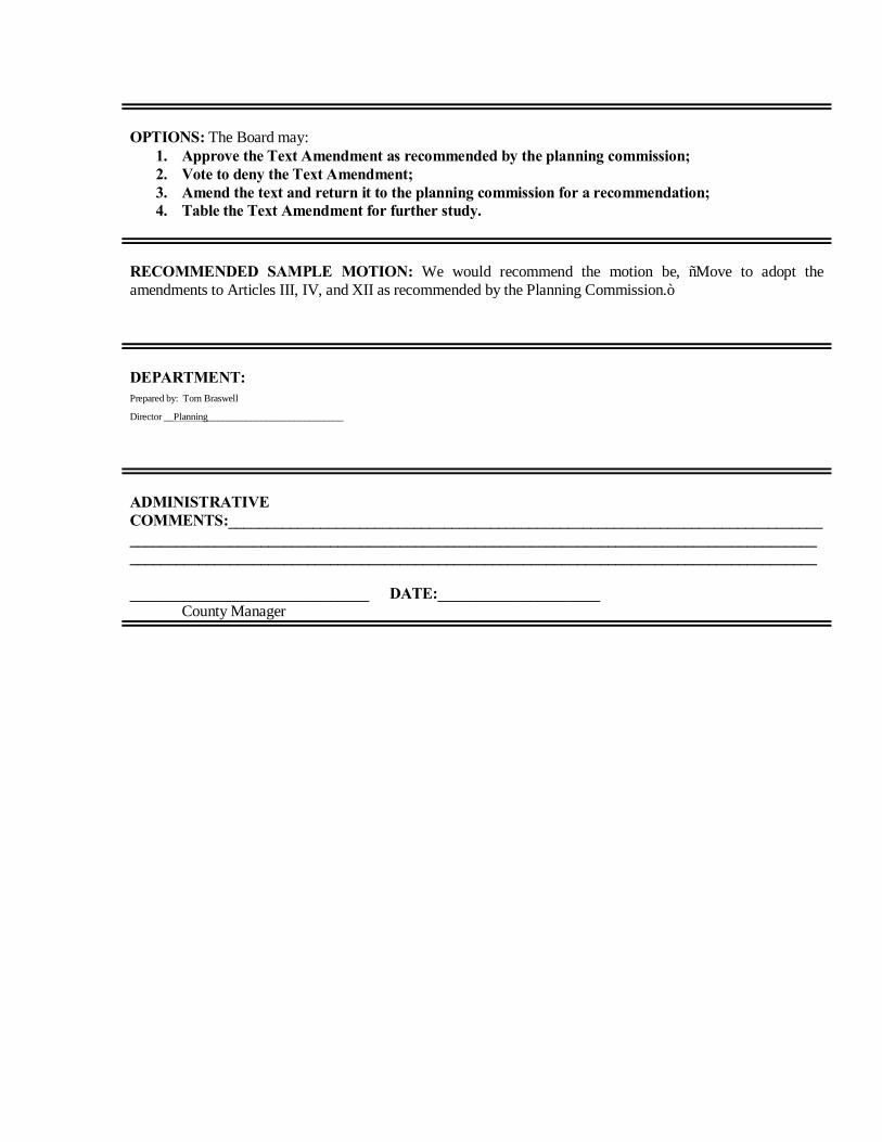
OPTIONS: The Board may:
1. Approve the Text Amendment as recommended by the planning commission; 2. Vote to deny the Text Amendment; 3. Amend the text and return it to the planning commission for a recommendation; 4. Table the Text Amendment for further study.
RECOMMENDED SAMPLE MOTION: We would recommend the motion be, “Move to adopt the amendments to Articles III, IV, and XII as recommended by the Planning Commission.”
DEPARTMENT: Prepared by: Tom Braswell
Director __Planning____________________________
ADMINISTRATIVE COMMENTS:_______________________________________________________________________________________________________________________________________________________________________________________________________________________________________________________________ _______________________________ DATE:_____________________ County Manager
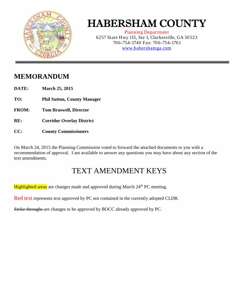
MEMORANDUM DATE: March 25, 2015 TO: Phil Sutton, County Manager FROM: Tom Braswell, Director RE: Corridor Overlay District CC: County Commissioners On March 24, 2015 the Planning Commission voted to forward the attached documents to you with a recommendation of approval. I am available to answer any questions you may have about any section of the text amendments.
TEXT AMENDMENT KEYS
Highlighted areas are changes made and approved during March 24th PC meeting. Red text represents text approved by PC not contained in the currently adopted CLDR. Strike throughs are changes to be approved by BOCC already approved by PC.
HABERSHAM COUNTY Planning Department
6257 State Hwy 115, Ste 1, Clarkesville, GA 30523 706-754-1740 Fax: 706-754-1761
www.habershamga.com
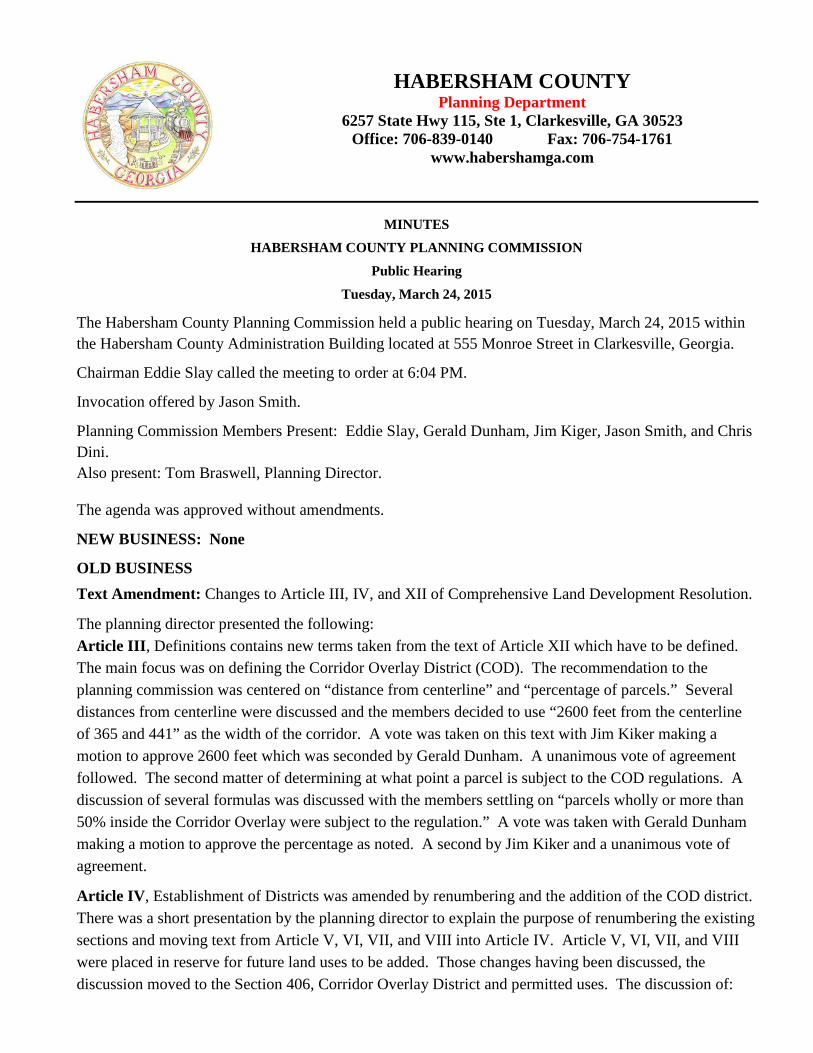
MINUTES HABERSHAM COUNTY PLANNING COMMISSION
Public Hearing
Tuesday, March 24, 2015
The Habersham County Planning Commission held a public hearing on Tuesday, March 24, 2015 within the Habersham County Administration Building located at 555 Monroe Street in Clarkesville, Georgia.
Chairman Eddie Slay called the meeting to order at 6:04 PM.
Invocation offered by Jason Smith.
Planning Commission Members Present: Eddie Slay, Gerald Dunham, Jim Kiger, Jason Smith, and Chris Dini. Also present: Tom Braswell, Planning Director.
The agenda was approved without amendments.
NEW BUSINESS: None
OLD BUSINESS Text Amendment: Changes to Article III, IV, and XII of Comprehensive Land Development Resolution.
The planning director presented the following: Article III, Definitions contains new terms taken from the text of Article XII which have to be defined. The main focus was on defining the Corridor Overlay District (COD). The recommendation to the planning commission was centered on “distance from centerline” and “percentage of parcels.” Several distances from centerline were discussed and the members decided to use “2600 feet from the centerline of 365 and 441” as the width of the corridor. A vote was taken on this text with Jim Kiker making a motion to approve 2600 feet which was seconded by Gerald Dunham. A unanimous vote of agreement followed. The second matter of determining at what point a parcel is subject to the COD regulations. A discussion of several formulas was discussed with the members settling on “parcels wholly or more than 50% inside the Corridor Overlay were subject to the regulation.” A vote was taken with Gerald Dunham making a motion to approve the percentage as noted. A second by Jim Kiker and a unanimous vote of agreement.
Article IV, Establishment of Districts was amended by renumbering and the addition of the COD district. There was a short presentation by the planning director to explain the purpose of renumbering the existing sections and moving text from Article V, VI, VII, and VIII into Article IV. Article V, VI, VII, and VIII were placed in reserve for future land uses to be added. Those changes having been discussed, the discussion moved to the Section 406, Corridor Overlay District and permitted uses. The discussion of:
HABERSHAM COUNTY Planning Department
6257 State Hwy 115, Ste 1, Clarkesville, GA 30523 Office: 706-839-0140 Fax: 706-754-1761
www.habershamga.com
• Section 406 (B), Permitted Uses followed with consideration given to what types of uses were appropriate for the COD based on the visioning of the 2029 Comprehensive Plan. The planning director offered some guidance here by suggesting that use of specific business types, such as restaurant, physician offices, car dealership, etc., be avoided. Use more general categories which captures more of the desired developments while omitting those less desirable developments. The members reviewed previously discussed land uses and others suggested by GMRC during workshops. A short list was created.
• Section 406 (C), Conditional Uses was discussed and several uses were placed in this section. These uses fit the corridor vision but because of their nature and level of impact would require a more intensive review with an opportunity for the community to have input at a public hearing or workshop.
Having completed the discussion and with no further comments, the chairman called for a motion on Article IV. Jason Smith made a motion to approve which was seconded by Chris Dini. A unanimous vote of agreement followed.
Article XII, Subdivision and Commercial Development Standards was the final text amendment to consider. This article was divided into three parts: PART I SUBDIVISION REGULATIONS PART II. ROADWAYS, STREETS, AND RIGHT-OF-WAY STANDARDS PART III CORRIDOR OVERLAY DEVELOPMENT STANDARDS
Part I and II contain the original text of Article XII with all new text being placed in Part III. The discussion of Part III was long and very detailed because of the level of regulation contained in it. All the architectural, landscaping, parking, and roadway standards for developing in the COD are in this Part. The discussion of Part III was conducted by the chairman with the planning director answering questions from the members as necessary. This was the fifth opportunity for the members to consider this text and any final changes. Several text changes were suggested by various members and noted by the planning director on the active document visible on the large screen monitor in the room. After a lengthy discussion of the effect this document would have on properties inside the COD and the owners of such property, the chairman asked if any additional changes or corrections were needed. The document was then reviewed from the developer’s perspective. With members having backgrounds in development, engineering, finance, government, and construction, the discussion was very productive. It was agreed among the members that the document was fair to the developer and offered a good level of protection for the residents along the COD. With no further questions or comments the chairman called for a motion from the members. Gerald Dunham moved to send the text amendment forward to the Board of Commissioners with a recommendation of approve as amended. Chris Dini seconded and a unanimous vote followed.
REPORTS TO COMMISSION: None ADMINISTRATIVE MATTERS: Training The planning director presented the schedule of training classes available for members in April and May.
ADJOURNMENT With no further business for discussion and no reports to the commission, the Chairman called for a motion to adjourn. Jason Smith made a motion to adjourn which was seconded by Chris Dini. Vote was unanimous. Meeting was adjourned at 8:26 PM.
As approved by the Habersham County Planning Commission:
Executive Secretary Date
ARTICLE III. DEFINITIONS OF TERMS USED IN RESOLUTION Section 301. Definitions.
When used in this appendix, the following words and phrases shall have the meaning given in this article. Terms not herein defined shall have their customary dictionary definitions where not inconsistent with the context. The term "shall" is mandatory. When not inconsistent with the context, words used in the singular number include the plural and those used in the plural number include the singular. Words used in the present tense include the future.
Abandoned sign/abandoned outdoor advertising: A sign shall be considered abandoned when the business activity or firm which such signs advertises, is no longer in operation, production or in existence.
Abandoned sign. A sign shall be considered abandoned when the sign owner is no longer in operation or does not have a current occupational tax certificate and/or business license in effect.
Abutting: Having property or district lines in common, or having property separated by only an alley.
Access easement: An easement, as defined herein, devoted to vehicular access which affords a principal means of access to abutting property or properties, but which is not necessarily open to the general public and which is not necessarily improved.
Accessory building: A building which is subordinate to and serves a principal building; is subordinate in area, extent, or purpose to the principal building served; contributes to the comfort, convenience or necessity of occupants of the principal building; and is located on the same lot as the principal building.
Accessory Equipment” means any equipment serving or being used in conjunction with a wireless facility or wireless support structure and includes, but is not limited to, utility or transmission equipment, power supplies, generators, batteries, cables, equipment buildings, cabinets, and storage sheds, shelters
Accessory use: The use of land that is subordinate to, incidental to and customarily found in connection with the principal use allowed on a lot by the applicable resolution, ordinance or law.
Acre: 43,560 square feet of area. Acre-foot: The volume that would cover one acre to a depth of one foot. Administrative officer: The director of the planning department. Administratively Granted Authorization means a review process whereby the Planning
Department may authorize approve an applicable permit and that does not require a public hearing or vote by the Planning Commission or Board of Commissioners
Advertising sign/billboards/outdoor advertising: Any structure or portion thereof, on which lettered, figured pictorial matter, illuminated or non-illuminated is displayed for advertising purposes, identification, description, or illustration to the general public.
Aggregate sign area means the area of all signs on a parcel.
Agriculture: The cultivation or growth of a field or horticultural crop, including dairying, livestock and poultry raising, aquaculture, forestry, and other similar enterprises or uses. The process of producing food, feed, fiber, fuel, and other goods by the systematic raising of plants and animals.
Airport: Any area of land, water or mechanical structure which is used for the landing and take off of aircraft, including any appurtenant structures and areas which are used or intended to be used for airport buildings, other airport facilities, rights-of-ways or easements.
Alley: A public way which affords a secondary means of access used primarily for vehicular service access to the back or side of properties otherwise abutting on a street and is not intended for general traffic circulation.
Alteration: Any change in the supporting members of a building, any modification or change in construction, any addition which increases the area or height, any change in use from that of one district classification to another, or movement of a building from one location to another.
Animal hospital: A facility operated by a licensed veterinarian specifically for the practice of veterinary medicine.
Animated sign: Any sign of which all or any part thereof visibly moves or imitates movement in any fashion whatsoever; and any sign which contains or uses for illumination any light(s) or lighting device(s) which change color, flash, or alternate, show movement or motion or change the appearance of said sign or any part thereof automatically. Wind activated elements such as flags or banners are excluded.
Animated sign means a sign or part of a sign that uses movement or change of natural light, artificial light, color effects, or physical position by any means whatsoever to depict action or create a special effect or scene or give the impression of movement. The term "animated sign" does not include signs which indicate time, temperature or date or signs which rotate less than five times per hour.
Antenna: Any exterior apparatus designed for wireless telecommunication, radio, or television communications through sending and/or receiving of electromagnetic waves.
Antenna means communications equipment that transmits and receives electromagnetic radio signals used in the provision of all types of wireless communication services
Antique shop: A store or shop for the sale of relics, objects of ancient times or of an earlier period, works of art, pieces of furniture or decorative objects made at a much earlier period than present.
Apartment house: A multi-family dwelling located on a parcel of land under a single ownership, designed for use by three or more housekeeping units, living independently of each other, and doing their own cooking on the premises.
Applicant means anybody submitting an Application for a Permit or other approval under this Resolution.
Area of a sign or sign area means the area within a continuous perimeter enclosing the limits of writing, representation, emblem, or any figure of similar character together with any frame, other material, open space, or color forming an integral part of the display or used to differentiate such writing, representation, emblem or any figure of similar character from the background against which it is placed. For double-faced signs, only the largest display face shall be measured in computing the sign area.
Art gallery: A facility, structure or building used for the display of sculptures, paintings, photographs or other artistic works for public viewing with only incidental sales.
Awning/canopy sign means a sign located on a roof-like cover extending before a place as a shelter and which may be used in lieu of a wall sign.
Bakery/bake shop: The use of a structure or building for the production and retail sale of bakery products, including but not limited to breads, cakes, pastries, and doughnuts. Wholesale bakeries are not included in this definition.
Banner: A flexible substance (such as cloth, plastic, or paper) on which copy or graphic may be displayed. It is characteristically suspended along or across any street, from a building, or towed by or attached to an aircraft or other mobile machinery.
Banner means a temporary flag, bunting, pennant, streamer or other flexible sign characteristically hung on a building or a pole or otherwise suspended down or along the face of a building or across any public street of the county. The banner may or may not include copy or other graphic symbols but is intended to display a message of temporary significance or garner the attention of the passing public. The term "banner" does not include flags of the United States of America or any of its several states' flags which are specifically excluded hereby from regulation by this article so long as said flags are of standard size and height.
Basement: A story of a building located wholly or partly underground but having less than one-half of its height above the average grade.
Beacon: Any light with one or more beams directed into the atmosphere or directed at one or more points not on the same zone as the light source; also, any light with one or more beams that rotate or move.
Berm: An earthen structure used as a screening device in conjunction with the planting of grass, shrubbery and trees.
Billboard sign means a stanchion sign with a sign area between 100 square feet and 150 square feet, the maximum square footage for signage within the county.
Block: A piece or parcel of land entirely surrounded by public streets (other than alleys), river, streams or U.S. government property, regardless of size, shape, or number of lots therein.
Board means the Board of Commissioners of Habersham County, Georgia, also referred to as local governing authority or governing body.
Board Designee means staff member or his designee employed by the County. Boarding house: A building, where for compensation, both lodging and meals are provided
for persons, provided that a single-family dwelling shall not be deemed to be a boarding house by reason of a contribution to or expense sharing arrangement with the owner or tenant occupying the dwelling by a person related by blood or marriage.
Broadcasting studio: A room or suite of rooms operated as a radio or television broadcasting studio or station with local broadcast capability or intended for satellite distribution of programs.
Buffer, planted: A landscaped open space and/or screen located between incompatible land uses for the purpose of visibly separating uses through distance and to shield or block noise, light, glare, or visual or other nuisances; that portion of a given lot, not covered by buildings, pavement, parking, access and service areas, established for the purpose of screening and separating properties with incompatible land uses, the width of which is measured from the common property line and extending the developed portion of the common property line.
Buffer, natural: A buffer consisting of trees, shrubs and other natural vegetation for ground stabilization undisturbed by grading or site development and/or replanted where sparsely vegetated or where disturbed for approved access and utility crossings.
Bufferyard: a unit of land together with required landscaping which may be required between land uses to eliminate or minimize conflicts between them.
Buildable area: The portion of a lot remaining after required yards, buffers and building setbacks have been provided.
Building: Any structure, either temporary or permanent, above or below ground, having a roof or other covering, and designed, built, or used as a shelter or enclosure for persons, animals, or property of any kind, including tents, awnings, or vehicles used for purposes of a building.
Building addition: Any walled and roofed expansion to the perimeter of a building in which the addition is connected by a common load bearing wall other than a firewall. Any walled and roofed addition which is connected by a firewall or is separated by independent perimeter load bearing walls is new construction.
Building, elevated: A non-basement building built to have the lowest floor elevated above the ground level by means of fill, solid foundation perimeter walls, pilings, columns (posts and piers), sheer walls, or breakaway walls.
Building line: The perimeter of that portion of a building or structure nearest a property line but excluding open steps, terraces, cornices, and other ornamental features projecting from the walls of the building or structure. Porches, decks, roof overhangs greater than 30 inches, and similar features are considered a part of the building or structure for the purpose of determining building line and setbacks.
Building marker: Any sign indicating the name of a building, the date, and incidental information about its reconstruction, and is cut into masonry surface or made of bronze or other permanent material.
Building sign: Any sign attached to any part of a building to identify or indicate the name or address of the building.
Business/office center or complex sign: A sign located on a single parcel of land which is planned, developed and managed as an unit by a single owner or landlord on contiguous lots containing three or more businesses or establishments, including all types of retail, wholesale, industrial and services which provide parking facilities.
Building, principal: A building or structure in which is conducted the main use of the property on which the building or structure is located.
Building setback line: A line establishing the minimum allowable distance between a building, including any covered porches, and the street right-of-way, edge of private road, or property line when measured perpendicularly thereto. In cases where no right-of-way has been documented or established, the required front building setback shall be measured from, a point ten feet from the existing construction limits of the road when the road lies within a public street right-of-way or private road.
Bulk: A term used to describe the size and shape of a building or structure and its relationship to other buildings, to the lot area for a building and to open spaces and yards.
Bus terminal: An area and building where buses stop to load and unload passengers and luggage or packages and which may include the sale of bus tickets.
Campground: Land containing two or more campsites which are located, established or maintained for occupancy by people in temporary lodging units such as camp tents, or cabins, for recreation, education or vacation purposes. Recreational vehicles may constitute as many as 25 percent of the total temporary lodging within the campground.
Canopy: Any permanent roof-like structure, including awnings and marquees, projecting beyond a building or extending along and projecting beyond the wall of a building, generally designed and constructed to provide protection form the weather.
Canopy sign: Any sign attached to, or made part of the front, side, or top of a canopy, awning or marquee.
Car wash: An establishment engaged in the business of washing domestic vehicles with self-serve, automated or staffed facilities.
Carport: An accessory structure or portion of a principal structure, consisting of a roof and supporting members such as columns or beams, unenclosed from the ground to the roof on at least two sides, and designed or used for the storage of motor vehicles.
Centerline of street or road: That line surveyed or designated by the governing body as the center of a street or road. If a centerline has not been surveyed or designated, it shall be the line running midway between the outside curbs, ditches or pavement ends of such street or road.
Certificate of occupancy: A legal statement or document issued by the building official or authority having jurisdiction (AHJ) indicating that the building and use or reuse of a particular building or land is in conformity with all applicable codes and regulations.
Changeable copy sign.
(1) Automatic changeable copy sign (ACCS) means a sign on which the copy changes automatically or by remote control. The term "ACCS" includes mechanically operated devices which change the copy through rotation of any type of panel and also signs which are illuminated partially or entirely by a matrix of electric lamps that are electronically changeable. An ACCS must contain a default design that will freeze the sign in one position if a malfunction occurs.
(2) Manual changeable copy sign means a sign on which copy is changed manually in the field, e.g., reader boards with changeable letters.
(3) Smartboards means a sign, display or device that changes the message or copy on the sign by means of a liquid crystal display. Smartboards may not incorporate animation or scrolling in the copy or change of copy. Notwithstanding other transition regulations, each message displayed on a smartboard when changed must be accomplished within an interval no greater than one second. Smartboard signs must contain a default design that will freeze the sign in one position if a malfunction occurs.
Changing sign/electronic message board means a sign that is capable of changing the position or format of word messages or other displays on the sign and that can also change the visible display of words, letters, numbers, symbols and graphics by the use of a matrix of electric lamps, movable discs, movable panels, light apertures or other methods when such changes are actuated by a control mechanism rather than manually, whether or not the message appears to move across the sign face. A sign that changes no more frequently than once every 24 hours shall not be considered a changing sign. A changing sign shall include electronic message boards and changeable copy signs.
Circus: The temporary use of land offering entertainment and instruction in the form of such things as thrill rides, games of chance and skill, educational exhibits, display of oddities and the like. The term also includes carnivals and fairs.
Club: A building or facility owned or operated by a group for social, educational, or recreational purposes, but not customarily for profit or to render a service that is customarily carried on for financial gain.
Collocation means the placement or installation of new wireless facilities on previously approved and constructed wireless support structures in a manner that negates the need to construct a new freestanding wireless support structure. Such term includes the placement of related accessory equipment within an existing equipment compound.
Compatibility: The characteristics of different uses or activities that permit such uses or activities to be located near each other in harmony and without conflict. Some elements affecting
compatibility include: intensity of occupancy as measured by dwelling units per acre or gross square footage per acre; pedestrian or vehicular traffic generated; volume of goods handled, and such environmental affects as noise, vibration, odor, glare, air pollution, or radiation.
Commercial use: Any non-residential or industrial use not defined as a residential use in this section.
Comprehensive plan: Those coordinated plans or portions thereof which have been prepared by or for the governing body for the physical development of the jurisdiction; or any plans that designate regulations or programs to encourage the most appropriate use of the land in the interest of public health, safety and welfare or any plan by a regional development center covering the center's region proposed or prepared pursuant to be minimum planning standards and procedures for preparation of comprehensive plans and for implementation of comprehensive plans, established by the department of community affairs in accordance with O.C.G.A. 50-8-1 through 50-8-12. (Note: this is the same definition as used in O.C.G.A. 50-8-2).
Comprehensive Plan means the Habersham County 2029 Comprehensive Plan Update adopted October 2008, as amended, prepared following the rules of the Georgia Department of Community Affairs, Chapter 1110-12-1-05, and effective May 1, 2005
Conditions to zoning approval: A requirement adopted by the governing body at the time of approval of a rezoning or conditional use which places greater or additional requirements or restrictions on the use and development of the subject property than provided in this zoning ordinance and is designed to ameliorate the negative effects of the rezoning or conditional use on neighboring properties and to protect the public health, safety, or general welfare.
Conditional use: A use which would not be appropriate without restriction throughout a land use intensity district and is not automatically permitted by right within a land use intensity district but which may be permitted within a land use intensity district subject to meeting specific conditions (such as controls on number, size, area, location and activities) contained in this appendix or required by the governing body. Such uses may be permitted only if approved by the governing body in accordance with the regulations established herein.
Condominium: A building or complex of multiple-unit dwellings in which a tenant holds full title to his unit and joint ownership in the common grounds.
Contractor's establishment: An establishment engaged in the provision of construction activities including but not limited to plumbing, electrical work, building, paving, carpentry and other such contracting activities, including the storage of materials and the overnight parking of commercial vehicles.
Convalescent home: A home for the care of children or the aged or infirm, or a place of rest for those suffering bodily disorders, wherein two or more persons are professionally cared for.
Convenience store: A small retail store, 10,000 square feet or less, which sells convenience items as its primary sales. A convenience store may include the sale of gasoline and diesel fuel but such sales shall be accessory to the primary sale of convenience goods.
Conversion: Any change in the original use or purpose of a building or lot to a different use. Copy: The wording or graphics on a sign surface in either permanent or removable form.
Corridor Overlay District: All that land which is wholly located within 2600 feet of the right-of-way centerline for Highway 365 and Highway 441 within Habersham County, and the entirety of each parcel for which more than 50% of the property lies within the designated corridor overlay district.”
Cottage industry: A processing, assembling, packaging, or storage industry, carried on for gain by at least one person residing on the property on which such establishment is located, not employing more than 15 persons, conducted entirely within the principal and accessory buildings on the property except for outside storage which meets the requirements of these regulations, and which does not generate more than 60 total vehicle trips per day nor generates noise, smoke, odor, dust, glare or vibration or flies/insects detectable at any property line and hereafter called rural business.
County or” Habersham County” means unincorporated Habersham County, Georgia Crest means the highest part of a hill or mountain range. Cul-de-sac: A street having one end open to traffic and being permanently terminated by a
vehicular turn-around. Curb cut: A provision for vehicular ingress and/or egress between property and an abutting
street or road. Day care center: A child care facility, pre-kindergarten, play or other special school for young
children (other than at public or private elementary schools) providing, for compensation, care and maintenance to seven or more children under age 17 for a period of 12 hours or less, typically during normal daytime hours. A day care center of six children or less is considered to be a residential business
DBH: Diameter at breast height, a term used in measurement of tree trunk. Density: The number of dwelling units developed, or to be developed, per gross acre of land,
or the gross square footage of a building per acre of land. Department: The Habersham County Building and Planning Department. Development: Any manmade change to improved or unimproved real estate, including but not
limited to, buildings or other structures, mining, dredging, filling, grading, paving, excavating, drilling operations, or permanent storage of materials or equipment.
Developmentally disabled person: A person with a disability resulting in substantial functional limitations in such person's major life activities which disability is attributable to mental retardation, cerebral palsy, epilepsy, or autism or is attributable to any other condition related to mental retardation because such condition results in impairment of general intellectual functioning or adaptive behavior similar to that of mentally retarded persons.
Directional sign: An unofficial or non-standard traffic control sign, intended to direct or regulate the movement of traffic and/or pedestrians. This includes but is not limited to "enter", "drive through", and directional arrow signs. These signs may be freestanding or mounted on a building.
Director: Director of the Habersham County Community Development Services Department or his/her designee.
District, land use intensity: A geographical area or areas, designated with the use of symbols on the official land use intensity map, wherein performance standards regarding type, size, height and other limitations on structures are established in this appendix. Said district permits the flexibility of mixed land uses (i.e. residential, commercial, and industrial) to exist within the same district.
Divided highway: Any state or federal route which has four or more travel lanes with a median dividing the directions of travel.
Double-faced sign means a sign which has two display areas placed back to back against each other or where the interior angle formed by the display areas is 60 degrees or less, where one face is designed to be seen from one direction and the other face from another direction.
Drive-in: A retail or service enterprise wherein service is provided to the customer within a motor vehicle on the outside of the principal building.
Drive-in theater: A facility designed for the outdoor projection of motion pictures onto a permanent screen to be viewed from the patron's automobile.
Driveway: A type of access or easement for local access to one or a small group of structures, and is owned and maintained by an individual or group.
Driveway, shared: A paved or gravel private road that may serve no more than four dwelling units or lots and does not connect thoroughfares. Shared driveways shall not be maintained by the governing body.
Dry cleaners: An establishment engaged in providing laundry, dyeing and dry cleaning services to individual customers.
Dry cleaning plant: An establishment engaged in providing laundry, dyeing and dry cleaning services on a large scale for institutions, businesses or other such establishments.
Dual faced sign: A sign containing two or more faces. Dwelling: A building, other than a motor home or travel trailer, that contains one or two
dwelling units used, intended or designed to be used, rented, leased, let or hired out to be occupied for living purposes.
Dwelling unit: A single unit providing complete, independent living facilities for one or more persons, including permanent provisions for living, sleeping, eating, cooking and sanitation, but not including units in hotels or other structures designed for transient residence.
Dwelling, multi-family: A building, under single ownership, designed for or occupied exclusively by three or more single housekeeping units with separate kitchen or housekeeping facilities for each family or housekeeping unit, including apartment houses, row houses, town houses, and similar housing types but not including motels, hotels, lodging houses, hospitals, nursing homes, or public institutions such as prisons and mental institutions.
Dwelling, single-family: A building designed or arranged to be occupied by one single housekeeping unit only.
Dwelling, two-family (duplex): A building designed or arranged to be occupied by two single housekeeping units living independently of each other.
Easement: A grant of one or more of the real property rights by the owner to, or for the use by, the public, a corporation, or another person or entity.
Easement, ingress/egress: An easement devoted to vehicular access which affords a principal means of access to abutting property or properties which are not necessarily open to the general public which is used in specific instances of subdivision of land and to comply with section 1117 of this appendix.
Easement, prescriptive: An implied easement that gives the easement holder a right to use another person's property for the purpose the easement holder has used the property for a certain number of years but does not convey the title to the property in question, only the right to utilize the property for a particular purpose. Electric sign: A sign containing electrical wiring but, excluding signs illuminated by an exterior light source.
Equipment Compound means an area surrounding or adjacent to the base of a wireless support structure within which accessory equipment is located
Electromagnetic interference: The result of electromagnetic radiation which is emitted by electrical circuits carrying rapidly changing signals, as a by-product of their normal operation, and which causes unwanted signals (interference or noise) to be induced in other circuits. This interrupts, obstructs, or otherwise degrades or limits the effective performance of those other circuits.
Exemption plat: A plat, drawn to final specifications, mapping the division of land which can be administratively approved by the administrative officer without the requirement to be considered by the Habersham County Planning Commission.
Expressway: (For the purposes of this Resolution) refers to the StHwy 365 from the Hall County line to the Stephens County line and Expressway 441 from the 365/441 split to the Rabun County line.
Exterminator: An establishment engaged in the service of killing insects, mice, rats, or other pests.
“FAA” means the Federal Aviation Administration, or its duly designated and authorized successor agency.
Family: An individual or two or more persons if related by blood, marriage, adoption or guardianship and not more than four unrelated persons, occupying a single dwelling unit and using the same cooking facilities. A family shall also include a personal care home of not more than six persons receiving personal care and two supervisory residents.
Farm: An area of land principally devoted to agriculture. Farm supply store: An establishment engaged in the retail sale of animal feeds, fertilizers,
agricultural chemicals, pesticides, seeds, and other such farm supplies. “FCC” means the Federal Communications Commission, or its duly designated and
authorized successor agency. Fence: A structural barrier for enclosure, screening or demarcation, presenting a solid face or
having openings amongst or between its constituents members; also, a wall separate from or extending from a building.
Flag: Any fabric, banner, or bunting containing distinctive colors, patterns, or symbols, used as a symbol of a government, political subdivision, or other entity.
Flashing sign means a sign of which the illumination is not kept constant in intensity at all times when in use or which exhibits sudden or marked changes in lighting effects. Changeable copy signs permitted in accordance with Section 14-34 shall be exempted from this definition.
Flood, base: The flood having a one percent chance of being equaled or exceeded in any given year, also known as the 100-year flood.
Flood, (flooding): A general and temporary condition of partial or complete inundation of normally dry land areas from the overflow of inland waters or the unusual and rapid accumulation of runoff of surface waters from any source.
Flood hazard area, special: Special flood hazard areas are those lands subject to periodic flooding and shown on the flood insurance rate map and/or flood hazard boundary map as a numbered or unnumbered "A" zone.
Flood hazard boundary map (FHBM): An official map of a community, issued by the Federal Emergency Management Agency, where the boundaries of the areas of special flood hazard have been designated as zone A.
Flood insurance rate map (FIRM): An official map of a community, on which the Federal Emergency Management Agency has delineated both the areas of special flood hazard and the risk premium zones applicable to the community.
Flood insurance study: The official report provided by the Federal Emergency Management Agency containing flood profiles as well as the flood hazard boundary-floodway map and the water surface elevation of the base flood.
Floodproofing: Any combination of structural and nonstructural additions, changes, or adjustments to structures which reduce or eliminate flood damage to real estate or improved real property, water and sanitary facilities, structures and their contents.
Flood plain: An area within the flood contour elevations subject to periodic flooding as designated by federal, state, regional, county or local studies.
Floodway: The channel of a river or other watercourse and the adjacent land areas that must be reserved in order to discharge the base flood without cumulatively increasing the water surface elevation more than one foot.
Floor: The surface on which people walk of an enclosed area in a building (including basement), i.e., top of slab in concrete slab construction or top of wood flooring in wood frame construction. The term does not include the floor of a garage used solely for parking vehicles.
Floor area: The gross heated, finished horizontal area of the floor or floors of a dwelling unit, exclusive of basement, attic, carport or garage.
Forestry: The management of forest lands for wood, forage, water, wildlife, and recreation. The farming of trees to ensure a continuing supply of timber and other forest products.
Freestanding sign: A sign principally supported by a structure affixed to the ground, and not supported by one or more columns, poles or braces placed in or upon the ground.
Freestanding sign means a sign securely affixed to a support structure which is permanently attached to the ground and wholly independent of any building for support such as monument or stanchion signs.
Fringe means at the outer edge of developed areas and/or property lines. Front of building: The exterior wall of a structure parallel to the public way. Frontage
property: The length of the property line(s) of any single premise along either a public way or other properties on which it borders.
Functionally dependent facility: A facility which cannot be used for its intended purpose unless it is located in close proximity to water, such as a docking or port facility necessary for the loading or unloading of cargo or passengers, shipbuilding, or ship repair, but not including long-term storage, manufacture, sales or service facilities.
Furniture finishing and repair: An establishment engaged in the stripping, cleaning, painting, staining, sealing, varnishing, or other like refinishing of the wood or metal components of furniture or the replacement or repair of broken or missing portions of a piece of furniture.
Garage: An accessory building or portion of a principal building used only for the private storage of motor vehicles and other personal property as an accessory use.
Governing body: The Habersham County Board of Commissioners.
Greenhouse: A building designed or used for growing or propagating plants, with walls or roof usually designed to transmit light. Greenhouses shall not be construed to include commercial horticultural activities.
Guesthouse: A lodging unit for temporary guests in an accessory building. No such lodging unit shall contain independent cooking or kitchen facilities and shall not be rented or otherwise used as a separate dwelling.
Habitable Structures means a space in a building for living, sleeping, eating, and cooking for humans
Hazardous waste: Any solid waste which has been defined as a hazardous waste in regulations, promulgated by the administrator of the United States Environmental Protection Agency pursuant to the federal act, which are in force and effect on February 1, 1988, codified as 40 C.F.R. Section 261.3. (Note: This is same definition as used in the Georgia Hazardous Waste Management Act.)
Health department: The County Health Department of Habersham County, Georgia. Height, wireless support structure” means the distance measured from the pre-existing grade
level to the highest point on the structure, even if said highest point is an antenna. Height, building: The vertical distance measured from the grade to the highest point of the
coping of a flat roof; to the deck lines of a mansard roof; or to the mean height level between the eaves and ridge of a gable, hip, or gambrel roof. Grade is defined as the average elevation of the ground on all sides of a building.
Heliport: An area, either at ground level or elevated on a structure, licensed or approved for the landing and take off of helicopters, and including auxiliary facilities such as parking, waiting room, fueling, and maintenance equipment.
Helistop: A heliport, but without auxiliary facilities such as parking, waiting room, fueling, and maintenance equipment.
Home occupation: A detached single-family dwelling where a use, occupation, or activity is conducted entirely within the dwelling by the residents thereof, or within an accessory building, which is clearly incidental and secondary to the single-family use of the dwelling and does not change the residential character thereof.
Home occupation/cottage industry sign: A wall sign for a legally existing home occupation or cottage industry, or rural business or residential business.
Hospital: An institution providing health services, for in-patients and medical or surgical care of the sick or injured, including as an integral part of the institution, such related facilities as laboratories, out-patients department, training facilities, central service facilities and staff offices.
Hotel: A public commercial lodging facility intended for use as temporary residence including meals, entertainment and various personal services provided for compensation to persons traveling for business, tourism or other visitation purposes in which ingress and egress from all rooms is made through an inside lobby or office supervised by a person in charge at all hours.
Illuminated sign: A sign which gives forth artificial light or which is designed or arranged to reflect light from an independent source.
Illuminated sign means a sign that has light cast upon the sign from a source either internal to the sign or from an external light source directed primarily toward such sign.

Impervious surface: A manmade structure or surface which prevents the infiltration of stormwater into the ground below the structure or surface, including but not limited to, buildings, roads, driveways, parking lots, decks, swimming pools, and patios.
Inoperable vehicle: Any motorized vehicle, other than those vehicles characterized by temporary disrepair incapable of immediately being driven. Any motorized vehicle without a current vehicle registration tag shall be considered an inoperable vehicle.
Intensity: A measure of the degree to which land is developed based on density, use, mass, size, impact and traffic generation.
Junk/salvage yard: Any property involving the abandonment, parking, storage or disassembly of junked or inoperable vehicles or junked machinery, the abandonment, storage, sale, or resale of used auto parts, tires, scrap iron, metal; used plumbing fixtures, old stoves, refrigerators and other old household appliances, used brick, wood, or other building/structural materials, used paper, rags or other scrap materials.
Kennel: The housing, breeding, boarding or training of four or more dogs, cats, or other domestic animals for the purpose of providing income or revenue.
Laboratory: A place devoted to experimental study, such as testing and analyzing, but not including the manufacturing of product or products.
Land-disturbing activity: Any grading, scraping, excavating, or filling of land; clearing of vegetation; any other alteration of land which causes land and stream bank erosion, siltation or water pollution and any construction, rebuilding, or alteration of a structure. Land-disturbing activity shall not include activities such as ordinary timber maintenance and landscaping operations, individual home gardens, yard and grounds upkeep, repairs, additions or minor modifications to a single-family dwelling, and the cutting of firewood for personal use.
Land uses, existing: Any land use or land-disturbing activity, including all human endeavors directly associated with such use or activity, which, prior to the promulgation of the river corridor protection plan, falls within one of the following categories: is zoned for such use and expenditures in excess $2,500.00 have been made in preparation for construction in accordance with such zoning, all material have been submitted for approval by the governing authority, is fully approved by the governing authority, is under construction, or is completed.
Landfill: An area wherein solid wastes may be placed, but specifically excluding hazardous or radioactive wastes.
Landscape strip: That portion of a given lot, not covered by buildings, pavement, parking, access and service areas, established as landscaped open space, the width of which is measured from a given property line and extending the developed portion of the property line. A landscape strip, as distinguished from a buffer, may be disturbed by grading or side development but shall be maintained as landscaped open space. A landscape strip may consist of grass lawns, decorative planting, berms, walls, fences or other approved features designed and arranged to produce an aesthetically pleasing effect within and outside of the development.
Landscaping: Changing, rearranging or adding to the original vegetation or scenery of a piece of land to produce an aesthetic effect appropriate for the use to which the land is put. It may include reshaping the land by moving the earth, as well as preserving the original vegetation.
Landscaping service: An establishment engaged in performing a variety of lawn and landscaping services such as lawn fertilizing, mowing, spraying and planting, and the planting and maintenance of landscaping.
Laundromat: A business that provides home-type washing and drying machines for hire to be used by customers on the premises.
Library: A building in which literary, musical, artistic or reference materials are kept for use but not generally for sale.
Light emitting diode (LED) sign: Signs containing changing copy; moving signs involving motion or sound; "trivision" type signs; signs displaying moving pictures or images; LED signs; signs with content that changes more than once daily; signs with moving words; signs with waiving elements, whether motorized or wind powered; or similar moving signs.
Loading and unloading space: A space, typically with dimensions of 12 feet by 60 feet, logically and conveniently located for pickups and/or deliveries or for loading and/or unloading, scaled to delivery vehicles to be used, and accessible to such vehicles.
Local government: The governing authority of a political subdivision. Local Governing Authority” means a municipality or county that has adopted land use or
zoning regulations for all or the majority of land uses within its jurisdiction. Lodging house: A fraternity house, sorority house, dormitory, or other such building designed
and occupied, with or without separate kitchen or housekeeping facilities for each unit. Lot: A parcel of land in one ownership, legally transferable as a single unit of land, occupied
or capable of being occupied by a use, building, or group of buildings devoted to one or more uses, together with the customary accessory uses, structures, yards and open spaces belonging to the same, and having principal frontage on a public street, approved private street, or, in the case of nonconforming lots of record not fronting on a public street or approved private road, or an access easement complying with section 1117 of this appendix.
Lot area: The total horizontal area within the lot lines of a lot, exclusive of public street right-of-ways, private road right-of-ways, and easements.
Lot, corner: A lot abutting upon two or more streets or roads at their intersection. In the case of a corner lot, frontage shall be measured along the longer of the two lot frontages.
Lot coverage: The part or percent of a lot occupied by impervious surfaces. Lot depth: The mean horizontal distance from the front lot line to the rear lot line. Lot, double frontage: Any lot, other than a corner lot, which has frontage on two streets or
roads that do not intersect at a point abutting the property. In the case of a double frontage lot, frontage shall be measured along both lot frontages.
Lot, flag: A lot where terrain or geometry makes standard design or access impossible or impractical in which the portion fronting on a public street, or approved private street is less than the required minimum width for construction of a building or structure on a lot, as set forth in this appendix.
Lot frontage: The width in linear feet of a lot where it abuts the right-of-way of any public or private street.
Lot of record: A lot created by a division of land or, part of a subdivision, of which a plat or deed has been recorded in the records of the county superior court clerk; or a parcel of land of which the deed has been recorded in the same office as of the date of adoption of this appendix.
Lot width: The horizontal distance between the side lines of a lot measured at right angles to its depth along a straight line parallel to the front line at the minimum required building setback line.
Mail order office: An establishment which engages in the taking of requests for mail order or catalog merchandise by telephone, but not including the storage or distribution of such merchandise. The establishment where orders are picked up or taken in person is not considered a mail order office.
Major arteries means the major arteries in the county specifically meaning the following: State Highways 441, 365, 255, 197, 17, and 115.
Major Street between two streets adjacent to a parcel, means the street with the highest daily traffic count.
Mansard: An inclined decorative roof-like projection that is attached to an exterior building
facade. Manufactured home: A structure, transportable in one or more sections, which, in the traveling
mode, is eight body feet or more in width or 40 body feet or more in length or, when erected on site, is 320 or more square feet and which is built on a permanent chassis and designed to be used as a dwelling with or without a permanent foundation when connected to the required utilities and includes the plumbing, heating, air conditioning, and electrical systems contained therein; except that such term shall include any structure which meets all the requirements of this paragraph except the size requirements and with respect to which the manufacturer voluntarily files a certification required by the Secretary of Housing and Urban Development and complies with the standards established in the National Mobile Home Construction and Safety Standards Act of 1974, 42 U.S.C. Section 5401, et. seq. A travel trailer is not to be considered as a mobile home/manufactured home. For the purposes of this appendix any "relocatable home" as defined by "The Uniform Standards Code for Factory Manufactured Moveable Home Act" (Georgia Laws 1968, p. 415) shall be considered to be included in this definition.
Manufacturing, processing and assembling: The mechanical or chemical transformation of materials or substances into new products. The land uses engaged in these activities are usually described as plants, factories or mills and characteristically use power driven machines and materials handling equipment. Establishments engaged in assembling component parts of manufactured products are also considered under this definition if the new product is neither a fixed structure nor other fixed improvement. Also included is the blending of materials such as lubricating oils, plastic resins or liquors.
Marina: A facility for storing, servicing, fueling and securing and launching of boats and other private pleasure craft.
Menu board: A freestanding sign oriented to the drive-through lane for a restaurant that advertises the menu items available from the drive-through window, and which has no more than 20 percent of the total area for such a sign utilized for business identification.
Metes and bounds: A system of describing and identifying land by distances or measures (metes) and bearings or direction (bounds) from an identifiable point of reference, such as a monument or other marker or the corner of intersecting streets.
Mini-warehouse: A building or group of buildings in a controlled access and fenced compound that contains varying sizes of individual, compartmentalized stalls or lockers used for storage, including accessory office and/or night watchman's residence, but not including retail sale on the premises, commercial repair or other services, manufacturing or any other commercial use.
Mobile home: A structure, transportable in one or more sections, which, in the traveling mode, is eight body feet or more in width or 40 body feet or more in length or, when erected on site, is 320 or more square feet and which is built on a permanent chassis and designed to be used as a dwelling with or without a permanent foundation when connected to the required utilities and includes the plumbing, heating, air-conditioning, and electrical systems contained therein and manufactured prior to June 15, 1976. OCGA 8-2-131[2].
Mobile home/manufactured home park: Premises where more than two mobile homes/manufactured homes are parked for living or sleeping purposes, or where spaces or lots are set aside and offered for rent for use by mobile homes/manufactured homes for living or sleeping purposes, including any land, building, structure or facility used by occupants of mobile homes/manufactured homes on such premises. This definition shall not include mobile homes/manufactured homes sales lots.
Modification or Modify means the improvement, upgrade, expansion, or replacement of existing wireless facilities on an existing wireless support structure or within an existing equipment compound
Modular home: Any structure or component thereof, designed primarily for residential occupancy which is wholly or in substantial part made, fabricated, formed, or assembled in manufacturing facilities for installation, or assembly and installation, on the building site, and which is designed and constructed to conform to the local building code rather than a national housing or construction code.
Monument sign: A freestanding sign where the base of the sign structure is on the ground. Monument sign means a freestanding sign mounted directly upon the ground. Such sign may not be
attached to or be a part of or supported by the building in or to which the sign applies. A freestanding sign where the base of the sign structure is on the ground. The width of the sign structure can be no more than 120 percent of the width of the base.
Motel: A public commercial lodging facility intended for use as temporary residence including meals, entertainment and various personal services provided for compensation to persons traveling for business, tourism or other visitation purposes, distinguished from a hotel in that ingress and/or egress to and from all rooms is made primarily from an exterior walkway rather than from an interior lobby.
Museum: An establishment engaged in the procurement, care, study, and display of objects of historical, educational and cultural value and interest.
Multiple faced sign: A sign containing three or more faces. Natural vegetative buffer or buffer area: A river corridor containing the flora native to that
area. The natural floras for specific areas are described in Georgia Geologic Survey Bulletin 114, "the Natural Environments of Georgia." Habitats for endangered and threatened species may require human management of the river corridor in order to maintain those species.
Need means anything that is technically required for the wireless service to be provided primarily and essentially within the County of Habersham and creates the least physical and visual impact. This does not necessarily mean the internal design standards of the applicant, rather, need relates to the ability of the user-equipment to function as designed
Net acre: The area, in square feet, which remains after deducting the area under water and other lands dedicated for specific purposes.
NIER means Non-Ionizing Electromagnetic Radiation.
Nonconforming lot of record: A lot of record as defined herein, the area, width, frontage, or other characteristic of which fails to meet requirements of the land use intensity district in which it is located or fails to meet other provisions of this appendix.
Nonconforming sign: A nonconforming sign is a sign that was lawfully erected and maintained prior to the adoption of this appendix, and which by reason of such adoption fails to conform to applicable regulations and restrictions of this appendix.
Nonconforming sign means any sign that does not conform to the provisions of this article.
Nonconforming structure: Any building or structure which does not conform to the regulations governing the bulk, location, height or size of buildings or structures permitted in the district.
Nonconforming use: Any use of land lawfully existing at the effective date of this resolution or as a result of subsequent amendments to this appendix, which does not conform with the provisions established herein for the district in which it is located.
Nonprofit activity: An activity, project, operation or enterprise of a temporary nature carried on by a corporation or an organization qualified as an exempt organization under applicable provisions of the International Revenue Code.
Nuisance: Anything that interferes with the use or enjoyment of property, endangers public health or safety, or is offensive to the senses.
Nursing home: Any building in which aged, chronically ill or incurable persons are housed and furnished with meals and professional nursing care for compensation, but not including hospitals and mental health institutions.
Occupiable Structure means a room or enclosed space designed for human occupancy in which individuals currently congregate for amusement, educational or similar purposes, and which is equipped with means of egress and light and ventilation facilities.
OCGA means Official Code of Georgia Annotated Open air business: Any commercial establishment that displays products in a non-enclosed
area. Open space, landscaped: That portion or portions of a given lot, not covered by buildings,
pavement, parking, access and service areas, set aside and maintained as a buffer, landscape strip or other approved open area.
Parcel: A contiguous area of land described in a single description by a deed or other instrument or as one of a number of lots on a plat or plan, separately owned and capable of being separately conveyed. A parcel is a unit of land under unified ownership (with or without buildings).
Parking lot: Any public or private open area used for the express purpose of temporary storage of private motor vehicles. A parking lot may be the principal use on a given lot or an accessory use to the principal use on a given lot.
Parking space: An area having typical dimensions of not less than nine feet by 20 feet and 300 square feet including maneuvering space within a parking lot, to be used exclusively as a temporary storage space for a motor vehicle.
Pavement: Any finish road/street surfacing treatment. Permit-sign: A permit issued by the building department prior to the erection of a sign.
Permit-sign completion: A permit issued by the building department after the applicant has finished the erection of a sign in conformance with approved application and standards as set forth herein.
Permitted use: A use by right which is specifically authorized in a particular land use intensity district.
Perennial stream: A stream which flows throughout the whole year as indicated on a United States Geological Survey Quadrangle Map.
Perennial river: A river or section of a river that flows continuously throughout the year. Person means any individual, corporation, estate, trust, partnership, joint stock company, and
association of two (2) or more persons having a joint common interest, or any other entity. Personal care home: Any dwelling, whether operated for profit or not, which undertakes
through its ownership or management to provide or arrange for the provision of housing, food service, and one or more personal services for two or more adults who are not related to the owner or administrator by blood or marriage. O.C.G.A. 31-7-12(a) (1).
Personal service establishment: A business that primarily provides services generally involving non-medical care of a person or a person's apparel, including but not limited to barber shops, beauty salons, seamstress shops, shoe repair and shining shops, dry cleaning facilities, and laundromat. Eating and drinking places are not considered personal service establishments.
Personal Wireless Facility, See definition for “Wireless Telecommunications Facilities. Personal Wireless Services or PWS or Personal Telecommunications Service or PTS shall have
the same meaning as defined and used in the 1996 Telecommunications Act 47 USC 332(c) (7)(C) Pit privy (outhouse): A building or structure completely enclosed, containing a bench with
holes through which bodily waste is expelled. Planning coordinator: Planning director. Planning commission: The Habersham County Planning Commission as established in this
appendix and hereafter referred to as HCPC. Planning Department means the staff members employed by the County and positions created by the
Board of Commissioners to administer applicable local, state, and federal laws relating to the development of Habersham County
Planning Director means the person employed by the County to operate and manage the Planning Department and interpret and apply the applicable laws relating to development of the County.
Plat, final: A drawing of a subdivision showing completely and accurately all legal and engineering information and certification necessary for recording.
Plat, preliminary: A drawing showing proposed layout of a subdivision in adequate detail to convey to the planning commission, the board of commissioners or others, the concept and workability of a subdivision, but not complete in form or detail required for recording.
Platting authority: The planning commission, planning department, and/or board of commissioners as dictated by this appendix.
Portable sign: Any sign supported by its own frame or trailer, with or without wheels, which can be transported from one place to another. Portable signs include signs on vehicles
Porta-potty: A temporary restroom facility which is brought onto building sites to serve workers and removed once construction ceases.
Premises: A lot as otherwise used in this appendix.
Projecting wall sign: Any sign affixed or attached to a wall of a building, horizontally extending no more than 18 inches beyond the wall and which displays only one sign surface. Wall signs shall not extend further than 18 inches from the top of the wall into the roof area.
Protected river: Any perennial river or watercourse with an average annual flow of at least 400-cubic feet per second as determined by appropriate U.S. Geological Survey documents. However, those segments of river covered by the Metropolitan River Protection Act or the Coastal Marshlands Protection Act are specifically excluded from the definition of a protected river. In coastal areas, the seaward limit of any protected river shall be the inland limits of the jurisdiction of the Coastal Marshlands Protection Act.
Public officer: As used in O.C.G.A. 41-2-7 through 41-2-17, shall mean the Director of the Habersham County Building and Planning Department.
Public service signs: A sign erected by or on behalf of a governmental body, public officials, or public agencies to post legal notices, identify public property, covey public information, or direct/regulate pedestrian or vehicular traffic.
Public utility or utilities: A service or services provided by a public utility company or a private entity which provides such service or services and all equipment and structures necessary to provide such services.
Public use: Any building, structure or use owned and/or operated by the Federal Government, State of Georgia, Habersham County or other county, or municipality, or any authority, agency, board or commission of the above governments, which is necessary to serve a public purpose, such as but not limited to the following: government administrative buildings, police and fire stations, public health facilities and hospitals, public works camps, parks and community centers, public roads and streets, airports, water and sanitary sewerage storage, intake, collection and treatment and pumping facilities, public housing facilities, jails and correctional centers.
Radial spacing: A measurement with the sign forming the center of a circle and measurements taken in all directions from the sign.
Real estate sign: A temporary sign erected by the owner, or his agent, advertising the real property upon which the sign is located for rent, lease, or sale.
Recognized Historic Area means districts or locations identified as having historic and/or architectural significance through an ordinance, guideline, map, listing, or designated by a local, state, or federal government.
Recreation facility, commercial: A use of land involving some form of recreational activity or activities operated as a business and open to the public for a fee.
Recreational vehicle: A vehicle which is built on a single chassis; is 400 square feet or less when measured at the largest horizontal projection; is designed to be self-propelled or permanently towable by a light duty truck; and is designed primarily not for use as a permanent dwelling but as temporary living quarters for recreational, camping, travel or seasonal use.
Recreational vehicle park: Except as provided within campgrounds, as defined by this article, any lot of land upon which more than two recreational vehicle sites are located, established, or maintained for occupancy by recreational vehicles of the general public as temporary living quarters for recreation or vacation purposes.
Rehabilitation center: Facilities authorized or licensed by appropriate agencies for the primary purpose of rehabilitation of offenders against the law; persons with drug or alcohol abuse problems, mentally handicapped and/or physically handicapped persons.
Repairs and Maintenance means the replacement or repair of any components of a wireless without the addition, removal, or change of any of the physical or visually discernable components or aspects of a wireless facility that will alter the visible appearance of the facility as originally permitted.
Reservoir boundary: The edge of a water supply reservoir defined by its normal pool level. Residence for caretaker or night watchman: An accessory residence, which may be a mobile
home, located inside or in addition to the principal structure or use of a parcel of land, designed or occupied by security personnel for security reasons only.
Residential use: A structure designed and used as a one, two or three family dwelling, intended or built to be, rented, leased, let, or hired out to be occupied for living purposes.
Residential business: A retail or service establishment carried on for gain by at least one person residing on the property which such establishment is located, not employing more than five persons, conducted entirely within the principal or accessory building(s) on the property except for product display and except for outside storage which meets the requirements of these regulations, and which does not generate more than 20 total vehicle trips per day to/from the property nor generates noise, smoke, odor, dust, glare or vibration or flies/insects detectable at any property line.
Restaurant: Any place or premises used for sale, dispensing or service of food, refreshment or beverages.
Restaurant, drive-in: Any place or premises used for sale, dispensing or service of food, refreshment or beverage to person(s) in automobiles, including those establishments where customers may eat or drink on the premises.
Retail sales establishment, enclosed: A business which sells merchandise to the consumer of the merchandise, where storage, display and sales transactions are conducted entirely within an enclosed building, including but not limited to the sale of convenience goods, antiques, produce and apparel.
Review Committee: The Habersham County Planning Commission Revolving or rotating sign: A sign that revolves partially or fully about an axis. “Ridge” means an elongated crest or a linear series of crests or the long narrow horizontal line
formed by two sloping surfaces with slopes of 15% or more. Right-of-way, private: That area, distinguished from an access easement or public right-of-
way, which is fee simple ownership by property owners of the subdivision involved or other individuals, and which affords permanent access to abutting property or properties. A private right-of-way is distinguishable from a public street in that maintenance and ownership of the road and accessory improvements is by private individuals or an association rather than the governing body or another government.
Right-of-way, public: That area, distinguished from an access easement or private right-of-way, which is owned in fee-simple title by the governing body or other government, for the present or future use of roads, streets, and highways, together with its drainage facilities and other accessory or supporting uses and structures.
River bank: The rising ground, bordering a river, which serves to confine the water to the natural channel during the normal course of flow.
River corridor: All the land, inclusive of islands, not regulated under the Metropolitan River Protection Act (O.C.G.A. 12-5-440 through 12-5-457), or the Coastal Marshlands Protection Act (O.C.G.A. 12-5-280 through 12-5-293), in areas of a protected river and being within 100 feet horizontally on both sides of the river as measured from the river banks.
River corridor protection plan: That part of the local comprehensive plan which deals with the river corridor protection requirements specified in this appendix.
Road: A public or private thoroughfare which is open to the general public and which affords a principal means of access to abutting property or properties.
Roadbed: The graded portion of a road/street within top and side slopes, prepared as a foundation for the pavement structure and shoulder.
Road, private: An improved street, road or driveway within a private right-of-way of 30 feet or more dedicated, by deed or other legal instrument, which affords a principal means of access to abutting property or properties.
Road Classification: The Georgia Department of Transportation and Federal Highway Administration classification based on the Highway Functional Classification Concepts, 2013 Edition. All roadways in Habersham County shall be classified as:
1. Interstates: Interstates are the highest classification of Arterials and were designed and constructed with mobility and long-distance travel in mind. Since their inception in the 1950’s, the Interstate System has provided a superior network of limited access, divided highways offering high levels of mobility while linking the major urban areas of the United States.
2. Other Freeways and Expressways Roadways in this functional classification category look very similar to Interstates. While there can be regional differences in the use of the terms ‘freeway’ and ‘expressway’, for the purpose of functional classification the roads in this classification have directional travel lanes are usually separated by some type of physical barrier, and their access and egress points are limited to on- and off-ramp locations or a very limited number of at-grade
3. Other Principal Arterials These roadways serve major centers of metropolitan areas, provide a high degree of mobility and can also provide mobility through rural areas. Unlike their access-controlled counterparts, abutting land uses can be served directly. Forms of access for Other Principal Arterial roadways include driveways to specific parcels and at-grade intersections with other roadways. For the most part, roadways that fall into the top three functional classification categories (Interstate, Other Freeways & Expressways and Other Principal Arterials) provide similar service in both urban and rural areas. The primary difference is that there are usually multiple Arterial routes serving a particular urban area, radiating out from the urban center to serve the surrounding region. In contrast, an expanse of a rural area of equal size would be served by a single Arterial.
4. Minor Arterials provide service for trips of moderate length, serve geographic areas that are smaller than their higher Arterial counterparts and offer connectivity to the higher Arterial system. In an urban context, they interconnect and augment the higher Arterial system, provide intra-community continuity and may carry local bus routes. In rural settings, Minor Arterials should be identified and spaced at intervals consistent with population density, so that all developed areas are within a reasonable distance of a higher level Arterial. Additionally, Minor Arterials in rural areas are typically
designed to provide relatively high overall travel speeds, with minimum interference to through movement. The spacing of Minor Arterial streets may typically vary from 1/8- to 1/2-mile in the central business district (CBD) and 2 to 3 miles in the suburban fringes. Normally, the spacing should not exceed 1 mile in fully developed areas.
5. Major and Minor Collectors Collectors serve a critical role in the roadway network by gathering traffic from Local Roads and funneling them to the Arterial network. Within the context of functional classification, Collectors are broken down into two categories: Major Collectors and Minor Collectors. Until recently, this division was considered only in the rural environment. Currently, all Collectors, regardless of whether they are within a rural area or an urban area, may be sub-stratified into major and minor categories. The determination of whether a given Collector is a Major or a Minor Collector is frequently one of the biggest challenges in functionally classifying a roadway network. In the rural environment, Collectors generally serve primarily intra-county travel (rather than statewide) and constitute those routes on which (independent of traffic volume) predominant travel distances are shorter than on Arterial routes. Consequently, more moderate speeds may be posted.
1.6.Local Roads Locally classified roads account for the largest percentage of all roadways in terms of mileage. They are not intended for use in long distance travel, except at the origin or destination end of the trip, due to their provision of direct access to abutting land. Bus routes generally do not run on Local Roads. They are often designed to discourage through traffic.
Road; rural minor and urban residential: Typically serve to provide access to single and multiple residencies. Motorists using such streets generally include only residents and their visitors. Use of such streets by large trucks and other heavy vehicles is rare, except for occasional use by delivery and maintenance vehicles.
Road; rural major and collector: Those roads/streets that serve a dual function of providing access to abutting properties as well as providing through or connecting service between other local roads or higher type facilities. In rural areas, major access roads/streets and collectors may have a significant local continuity and may operate at relatively high speeds.
Road; rural arterial system minor: Forms a network with the following service characteristics:
a. Linkage to cities, towns and other traffic generators (such as major resort areas) that is capable of attracting travel over similarly long distances. b. Integrated interstate and inter-county service. c. Corridor movements consistent with the above items, with trip lengths and travel densities greater than those predominantly served by rural collector and local road systems. d. Minor arterials therefore constitute routes expected to provide for relatively high speeds and minimum interference to through movement.
Roadside stand: A structure, or portion thereof, for the shelter, display and sale of agricultural products produced on the premises, with no space for customers within the structure itself.
Roof line: The top edge of a peaked roof or in case of an extended facade or parapet, the uppermost point of said facade or parapet.
Roof sign: A sign mounted on, and supported by, the main portion of a building, or above the uppermost edge of a parapet wall of a building and which is wholly or partially supported by such a building.
Roof sign means a sign attached to, painted on or supported by the roof of a building that extends above the immediately adjacent eave line of the building. Rooming house: A building where, for compensation, lodging only is provided.
Rural business: A processing, assembling, packaging or storage industry, carried on for gain by at least one person residing on the property on which such establishment is located, not employing more than 15 persons, conducted entirely within the principal and accessory buildings on the property except for outside storage which meets the requirements of these regulations, and which does not generate more than 60 total vehicle trips per day nor generates noise, smoke, odor, dust, glare or vibration or flies/insects detectable at any property line.
Screening: A method of shielding or buffering one use from another by fencing, walls, berms, densely planted vegetation, natural vegetation or other means; a visual and acoustical barrier which is of such nature and density that provides year-round maximum opacity from the ground to a height of at least six feet or that screens structures and activities from view from the normal level of a first story window on an abutting lot.
Semi-public use: Any building, structure or use owned and/or operated by private utilities or private companies for a public purpose, or which is reasonably necessary for the furnishing of adequate service by such utilities, such as but not limited to the following: underground or overhead gas, electrical, steam or water distribution or transmission lines or systems, electric power substations, wires, towers, cables, and poles.
Sensitive environments maps: A set of maps, as established by this appendix, which provides the location and boundaries of significant groundwater recharge areas, wetlands, and water supply watersheds
Sensitive natural areas: Any area, as identified now or hereafter by the department of natural resources, which contains: habitat, including nesting sites, occupied by rare or endangered species, rare or exemplary natural communities, significant landforms, hydro forms, or geological features; or other areas so designated by the department of natural resources; and which are sensitive or vulnerable to physical or biological alteration.
Septic tank: An approved watertight tank designed or used to receive sewage from a building sewer and to effect separation and organic decomposition of sewage solids, and discharging sewage effluent to an absorption field or other management system.
Service drive: A public way used primarily for vehicular service access to the back or side of properties otherwise abutting on a street and is not intended for general traffic circulation.
Service station: Any building, structure or land used for the retail sale of motor vehicle fuel, oil, accessories, and motor vehicle servicing, except that major repairs, body repairs, and painting of motor vehicles shall not be considered motor vehicle servicing.
Setback: The minimum horizontal distance between a street, alley, or the property boundary lines of a lot and the front, rear, or side lines of a building located on that lot.
Shopping center: A group of commercial establishments, planned, developed, owned and managed as a unit, with off-street parking on the property.
Shoulder: The portion of the roadway contiguous with the traveled way for accommodation of stopped vehicles, for emergency use, and lateral support of base and surface courses.
Sight triangle: The area of visibility required on a corner to allow for the safe operation of vehicles, pedestrians, trains and cyclists in the proximity of intersecting streets, roads, rail lines, sidewalks and bicycle paths.
Sign: Any writing, pictorial presentation, illustration, or decoration, flag, banner or pennant or other device which is used to announce, direct attention to, identify, advertise or otherwise make anything known, and which is designed to be visible from any street or adjoining property, except for house numbers and address numbers and non-business letters on mailboxes. For the purposes of this appendix, any sign not visible from a street or adjoining property or any sign within a business, office, mall or totally enclosed area is exempted from this appendix.
Sign means a device or representation for visual communication that is used for the purpose of bringing the subject thereof to the attention of others.
Sign, animated: Any sign of which all or any part thereof visibly moves in any fashion whatsoever; and any sign which contains or uses for illumination any light, lights or lighting device or devices which change color, flash or alternate, show movement or motion, or automatically change the appearance of said sign or any part thereof.
Sign area: The entire area within a circle, triangle, or parallelogram enclosing the extreme limits of writing, representation, emblem, or any figure of similar character, together with any frame or other material or color forming an integral part of the display or used to differentiate the sign from the background against which it is placed; excluding the necessary supports or uprights on which such sign is placed. Where a sign consists solely of lettering or other sign elements printed or mounted on a wall of a building without any distinguishing border, panel, or background, any blank rectangular area which consists of ten percent or more of the area of the sign as otherwise computed shall be disregarded. All of the lettering and other sign elements printed or mounted upon a wall of a building without any distinguishing border, panel, or background and pertaining to the same enterprise shall be treated as a single sign for purposes of area computation. Where a sign has two or more faces, the sign area shall be counted as the area of one face if the all faces are of equal area or as the area of the largest face if the faces are of unequal area.
Sign, bench: A sign located on any part of the surface of a bench or seat placed on or adjacent to a public right-of-way.
Signs, community: Temporary signs, generally made of a woven material or durable synthetic materials primarily attached to or hung from light poles or on buildings. These signs are solely of a decorative, festive and/or informative nature announcing activities, promotional events, seasonal or traditional themes having broad community interest, and which are sponsored by Habersham County or a nonprofit organization located in Habersham County.
Sign, construction: Any sign giving the name or names and location of principal contractors, architects, and lending institutions responsible for construction on the site where the sign is placed.
Sign, directional: A sign temporarily or permanently erected on a site other than that to which persons are directed (off-site) which denotes the route to a particular destination.
Sign face: The surface upon, against or through which the sign copy is displayed or illustrated. Size restrictions or dimensions as to square feet are applicable only to the sign face.
Sign, flashing: A sign designed to attract attention through the use of a flashing, changing, revolving or flickering light source, or a change in light intensity.
Sign, ground: Any sign which is supported by structures or supports in or upon the ground and independent of support from any building.
Sign height: The distance in vertical feet from the elevation of the adjacent dedicated public street, at the edge of the pavement, to the highest point of the sign structure, measurements and dimensions include the sign face, above ground foundations, supports and braces. For property
with an elevation higher than the adjacent public street, the height shall be measured from the ground level at base of sign to highest point of the sign structure. The ground shall not be altered for the sole purpose of providing additional sign height.
Sign, identification: A sign which depicts the name and/or address of a building, subdivision or establishment on the premises where the sign is located as a means of identifying said building, subdivision or establishment.
Sign, internally illuminated: A sign illuminated with a light source which is enclosed within the sign and viewed through a translucent panel.
Sign, mansard: A sign attached to or erected against a mansard or marquee of a building, with the face parallel to the building wall. Since said sign is mounted parallel to and within the limitations of the building wall on which same is mounted, such sign is deemed to be a wall sign and not a roof sign.
Sign number: For the purposes of determining the number of signs, a sign shall be construed to be a single display surface or device containing elements organized, related and composed to form a single unit. A ground sign with sign surface on both sides of such sign shall be construed as a single sign, and the total area of such sign shall be the area computed on a single side. y
Sign, political: A sign which announces, promotes, or advertises the name, program, or political party of any candidate for public office, or an opinion regarding a public referendum.
Sign, portable: A sign, whether on its own trailer, wheels, or otherwise, which is designed to be transported from one place to another. It is characteristic of a portable sign that the space provided for advertising messages may be changed at will by the replacement of lettering or symbols. Even though the wheels or supports of such sign should be removed and the sign converted and attached, temporarily or permanently, to the ground or other structure, such sign shall retain its character as a portable sign based on its original design unless modified to change its original design through incorporation into a permanent ground sign.
Sign projecting: A sign other than a wall sign affixed and perpendicular to any building or wall and having a leading edge that extends more than one foot beyond such building or wall.
Sign, real estate: A temporary sign erected by the owner, or his agent, advertising the real property upon which the sign is located for rent, lease or for sale.
Sign, roof: Any sign erected, constructed and maintained wholly upon or over the roof of any building with the principal support on the roof structure.
Sign, sandwich: Any sign, double or single-faced, which is portable and may readily, be moved from place to place.
Sign structure: Any construction used or designed to support a sign. Sign, wall: A sign attached to or erected against the wall of a building with the face in a parallel
plane to the plane of the building wall. Significant groundwater recharge areas: Those areas, as indicated by the sensitive
environments maps, found by technical studies to contain thick soils, slopes lower than eight percent, rocks with little porosity, and other characteristics, where most groundwater is stored in the overlying soils.
Slaughterhouse: An establishment where animals are killed, butchered, and prepared for further processing.
Slope: The degree of deviation of a horizontal usually expressed in percentage or degrees. The ratio of the difference in elevation between two points on the ground and the horizontal distance between the two points.
Snipe sign: A sign of any material whatsoever that is attached in any way to a utility pole, tree, fence, rock, or any other similar object located on public or private property. Snipe signs shall not include "keep out", "posted", or "no trespassing" signs.
Stanchion sign means a freestanding sign mounted on one or more steel poles set in the ground and of sufficient strength and size to support the advertisement portion of such structure, which rests upon or is supported by such poles.
Stealth or Camouflage Technique means mechanisms to minimize adverse aesthetic and visual impacts on the land, property, buildings and other facilities adjacent to, surrounding, and in generally the same area as the requested location of a Wireless Telecommunications Facility, which shall mean using the least visually and physically intrusive facility that is not technologically or commercially impracticable under the facts and circumstances.
Story: That portion of a building comprised between a floor and the floor or roof next above. Stream corridor: All land within the buffer area and impervious surface setback area specified
for perennial streams within water supply watersheds. Stream natural buffer: A natural, vegetated area, with a specified required width adjacent to a
perennial stream, which allows no land disturbance; limited minor land disturbances, such as trails and picnic areas, may be allowed by the governing body.
Street: A public or private thoroughfare which is open to the general public and which affords a principal means of access to abutting property.
Street, public: An improved street or road within a dedicated and accepted public right-of-way which affords a principal means of access to abutting property or properties.
Street; rural minor and urban residential: Typically serve to provide access to single and multiple-residencies. Motorists using such streets generally include only residents and their visitors. Use of such streets by large trucks and other heavy vehicles is rare, except for occasional use by delivery and maintenance vehicles.
Street; rural major and collector: Those streets that serve a dual function of providing access to abutting properties as well as providing through or connecting service between other local roads or higher type facilities. In rural areas, major access streets and collectors may have a significant local continuity and may operate at relatively high speeds.
Street; rural minor arterial system: The rural minor arterial road system forms a network with the following service characteristics:
a. Linkage to cities, towns and other traffic generators (such as major resort areas) that are capable of attracting travel over similarly long distances. b. Integrated interstate and intercounty service. c. Corridor movements consistent with the above items, with trip lengths and travel densities greater than those predominantly served by rural collector and local road systems. d. Minor arterials therefore constitute routes expected to provide for relatively high speeds and minimum interference to through movement.
Structure: That which is built or constructed. Subdivider: One who divides land into two or more separate, usable lots for immediate or
future sale or development.
Subdivision: The division of a lot, tract or parcel of land into two or more lots, plats, sites or other divisions of land for the purpose, whether immediate or future, of sale or of building development where new roads, streets (public or private) and supporting infrastructure is required by this appendix.
Subdivision of land: The dividing of a parcel or tract of land into two or more lots, all of which have the required frontage on an existing public road or private street and complies with the dimensions and minimum acreage requirements of the Habersham County Land Development Resolution. Such divisions may be accomplished on existing lots of record not fronting on a public street or private road may be divided into a maximum of four lots by use of an easement as defined in this section for the purpose of access.
Subdivision, family: The subdivision of land for legacy or inheritance with principal means of ingress/egress as described in section 1117 of this appendix.
Subdivision entrance signs: Any sign designed to identify the entrance of a subdivision, neighborhood, residential complex, apartment or townhouse.
Substantial damage: Damage of any origin sustained by a structure whereby the cost of restoring the structure to its before-damaged condition would equal or exceed 50 percent of the market value of the structure before the damage occurred.
Substantial Evidence means such relevant evidence as a reasonable mind might accept as adequate to support a conclusion.
Substantial improvement: Any combination of repairs, reconstruction, alteration, or improvements to a building taking place in which the cumulative cost equals or exceeds 50 percent of the market value of said building.
Taxi cab station: An establishment engaged in furnishing passenger transportation by automobile or van, not operating on regular schedules or between fixed terminals and containing space for taxi cab fleets and related office facilities.
Telecommunications means the transmission and/or reception of audio, video, data, and other information by wire, radio frequency, light, and other electronic or electromagnetic systems.
Telecommunications Structure means a structure used in the provision of services described in the definition of ‘Wireless Telecommunications Facilities’.
Temporary means temporary in relation to all aspects and components of this Article, something intended to, or that does, exist for fewer than ninety (90) days.
Tower means any structure designed primarily to support an antenna for receiving and/or transmitting a wireless signal.
Townhouse: A single-family dwelling unit constructed in a group of three or more attached units in which each unit extends from the foundation to the roof and with open space on at least two sides and under fee simple ownership.
Traditional neighborhood as defined and identified in the 2029 Comprehensive Plan.. Travel trailer: A vehicular, portable structure built on a chassis, designed to be used as a
temporary dwelling for travel and recreational purposes, having a body width not exceeding eight feet.
Tree: Any self-supporting, woody perennial plant having a single trunk diameter, measured at DBH, of two inches or more which normally grows at maturity to an overall height of a minimum of 15 feet.
Truck stop: An area principally devoted to the service re-fueling, temporary storage or parking of trucks, including accessory buildings, structures and uses such as restaurants.
Truck terminal: An area where cargo is loaded, unloaded and stored on a regular basis. Under canopy sign: A sign that is suspended from the underside of a canopy (including
awnings marquees), is perpendicular to the wall surface of a building, and whose canopy is not clearly visible from a public right-of-way.
Unlawful sign (illegal sign): Any sign erected without a permit when a permit for the sign was otherwise required by this appendix or previously adopted resolution or code; or a permitted sign which has not been properly erected in accordance with its permit application and approved sign permit; or an otherwise lawful and permitted sign which has become hazardous or a nuisance to the public due to poor maintenance, dilapidation, or abandonment, and so declared by the administrative officer.
Use: Any purpose for which a building or structure or a tract of land may be designed, arranged, intended, maintained, or occupied; or any activity, occupation, business, or operation carried on, or intended to be carried on, in a building or structure or on a tract of land.
Utility: Public or private water or sewer piping systems, water or sewer pumping stations, electric power lines, fuel pipelines, telephone lines, roads, driveways, river/lake access facilities, stormwater systems and railroads.
Variance: A minimal relaxation or modification of the strict terms of the height, area, placement, setback, yard, buffer, landscape strip, parking and loading regulations, consistent with the criteria established within these regulations, as applied to specific property when, because of particular physical surroundings, shape, or topographical condition of the property, compliance would result in a particular hardship upon the owner.
Viewshed means an area of land, water, or other environmental element with esthetic value to be protected from adverse effects of development that is visible to the human eye from a fixed vantage point. These areas include but are not limited to ridges, mountains, hills, rural and natural lands, and streams, designated through ordinance, guideline, map listing, or designation by a local, state, or federal government.
Visual Impact Assessment means a computer aided photographic analysis of the visual impact on and around a proposed development site.
Visual quality: The appropriate design, arrangement and location of tower structures in relation to the built or natural environment to avoid abrupt or severe differences.
Wall means all of the vertical face of a building including any parapet but excluding the roof.
Wall sign means a sign fastened, placed or painted upon or parallel to the exterior wall of the structure whether front, rear or side of the structure.
Warehouse: A building or group of buildings for the storage of goods or wares, with access to contents only through management personnel.
Water supply reservoir: A governmentally owned impoundment of water for the primary purpose of providing water to one or more governmentally owned public drinking water systems, excluding multi-purpose reservoirs owned by the United States Army Corps of Engineers.
Water supply watershed: The area of land upstream of a governmentally owned public drinking water intake or water supply reservoir.
Wetlands: Those areas that are inundated or saturated by surface or groundwater at a frequency and duration sufficient to support, and that under normal circumstances do support, a prevalence of vegetation typically adapted for life in saturated soil conditions.
Wholesale distribution: An establishment engaged in selling merchandise to retailers, to industrial, commercial, institutional or professional business users or to other wholesalers.
Width, “Wireless Facility” shall mean the lateral measurement of any wireless facility array on a wireless support structure at the widest spot. The measurement of width shall not be limited by the array immediately above or below the wireless array being applied for.
Width, “wireless support structure” means the dimensions of the structure as noted on the design documents submitted at the time of application and used as a basis for approval by the Board.
Window sign: Any sign, excluding identification and incidental signs, placed inside or upon a window, containing a commercial message, and intended to be seen from the exterior.
Window sign means a sign installed flush with or on a window and intended to be viewed from the outside.
Wireless Facility means the set of equipment and network components, exclusive of the underlying wireless support structure. Including antennas, transmitters, receivers, base stations, power supplies, cabling, and accessory equipment used to provide wireless data and telecommunication services.
Wireless Support Structure means a freestanding structure, such as a monopole tower, either guyed or self-supporting, or suitable existing or alternative structure designed to support or capable of supporting wireless facilities. Such term shall not include any electrical utility pole or tower used for the distribution or transmission of electrical service.
Wireless Telecommunications Facilities means and includes a “Telecommunications Site” and “Personal Wireless Facility”. It means a structure, facility or location designed, or intended to be used as, or used to support Antennas or other transmitting or receiving devices. This includes without limit, Wireless support structures of all types, kinds and structures, including, but not limited to buildings, church steeples, silos, water towers, signs, or other structures that can be used as a support structure for Antennas or the functional equivalent of such. It further includes all related facilities and equipment such as cabling, equipment shelters, and other structures associated with the site. It is a structure and facility intended for transmitting and/or receiving radio, television, cellular, SMR, paging, 911, Personal Communications Services (PCS), commercial satellite services, microwave services and any commercial wireless telecommunication service not licensed by the FCC
Wrecked motor vehicle compound: An area used to store disabled motor vehicles until such time as their disposition (either by junk, salvage or repair) has been determined by the insurance company, the owner of the vehicle, or his legal representative.
Yard: A space on the same lot with a principal building, which is open, unoccupied, and unobstructed by buildings or structures. A yard may contain a parking and/or loading area unless otherwise specified by this appendix.
Yard, front: The area extending across the full width of the lot located between the front lot line or planned street line and the front building line.
Yard, rear: An open, unoccupied space on the same lot with a principal building, extending the full width of the lot and situated between the rear line of the lot and the rear line of the building projected to the side lines of the lot.
Yard, side: A space on the same lot with a principal building, situated between the building and the side lot line and extending from the rear line of the front yard to the front line of the rear yard.
Zero lot line: The location of a building on a lot in such a manner that one or more building sides have no side building set back and rest directly on a side lot line.
ARTICLE IV. ESTABLISHMENT OF DISTRICTS Section 401. Use districts.
For the purpose of this appendix, Habersham County is hereby divided into land use intensity districts as set out below:
AG, Agricultural Protection District LI, Low Intensity District MI, Moderate Intensity District HI, High Intensity District COD, Corridor Overlay District
The mountain protection plan and river corridor plan of Article XV may supersede some applicable standards of the afore-mentioned districts.
Section 402 A. Official land use intensity district map. The location and boundaries of the above listed districts are hereby established as shown on the
Official Land Use Intensity District Map of Habersham County, Georgia. Said map, together with all explanatory matter thereon, is hereby adopted by reference and declared to be a part of this appendix.
The official land use intensity district map shall be identified by the signature of the county commission chairman, attested by the county clerk, and bear the seal of the county under the following words: "This is to certify that this is the Official Land Use Intensity District Map referred to in Article IV of the Comprehensive Land Development Resolution, Habersham County, Georgia", together with the date of the adoption of the resolution.
If in accordance with the provisions of this appendix and the applicable laws of the State of Georgia, changes are made in boundaries or other matter portrayed on the official land use intensity district map, such changes shall be entered on the official land use intensity district map promptly after the amendment has been approved by the county commission, with appropriate entry or indication of such amendment on the official land use intensity district map. No amendment to this appendix which involves matter portrayed on the official land use intensity district map shall become effective until after such change and entry has been made on said map
No changes of any nature shall be made in the official land use intensity district map or matter shown thereon except in conformity with the procedures set forth in this appendix. Any unauthorized change of whatever kind by any person or persons shall be considered a violation of this appendix.
Regardless of the existence of purported copies of the official land use intensity district map which may from time to time be made or published, the official land use intensity district map which shall be located in the planning department and shall be the final authority as to the current district status of land and water areas, buildings, and other structures in the county.
Section 403 B.. Replacement of official land use intensity district map. In the event that the official land use intensity district map becomes damaged, destroyed, lost, or
difficult to interpret because of the nature or number of changes and additions, the county commission may adopt a new official land use intensity district map which shall supersede the prior official land use intensity district map.
Section 404 C. Interpretation of district boundaries. Where boundaries are indicated as approximately following the centerline of streets or highways,
street right-of-way lines or railroad right-of-way lines or such lines extended, such centerline, street right-of-way lines, or railroad right-of-way lines shall be construed to be such boundaries.
Where boundaries are indicated as approximately following the corporate limit line of a city, such corporate limit line shall be construed to be such boundaries.
Where boundaries are indicated as approximately following property lines or such lines extended, such property lines or such lines extended, as indicated by boundary survey, deed or legal description maintained in the official file of said property redistricting if available, shall be construed to be such boundaries.
Where boundaries are indicated as approximately following the centerline of stream beds or river beds, such centerline shall be construed to be such boundaries.
In the case where the exact location of a boundary cannot be determined by the foregoing methods, the county commission shall, upon application, determine the location of the boundary.
Section 405 D. Boundary line divides a lot of single ownership. Where a boundary line as appearing on the official land use intensity district map divides a lot in
single ownership at the time of the enactment of this appendix, the requirements for the district in which the greater portion of the lot lies shall be deemed to extend to the balance of the lot without recourse or amendment procedure, provided that this provision shall not apply to a double frontage lot.
In the case of a double frontage lot, the restrictions of the district applying to the adjoining lots which front on the same street as the longest lot frontage of the lot in question shall apply.
Section 406 E. Uses prohibited when not specified. Unless otherwise stated, any use not specifically permitted in a land use intensity district as
provided in this appendix shall be prohibited in that district.
ARTICLE V.SECTION 402 AG, AGRICULTURAL PROTECTION DISTRICT Section 501A. Purpose and intent.
The intent of the agricultural protection district is to establish a voluntary mechanism by which individuals and family-farm corporations owning property devoted to bona fide agricultural uses can be afforded protection from increases in land values due to encroachment by non-agricultural land uses, and can be afforded preferential tax assessment in accordance with the Official Code of Georgia Annotated (48-5-7 seq.). It is also the intent of this district to permit, in rural areas, home occupation, residential business, and rural business which may be compatible with agricultural and residential areas, subject to the limitations established in these regulations.
Section 502 B. Permitted uses. 1. Accessory uses and structures customarily incidental to one or more permitted uses.
2. Bona fide agricultural uses, including commercial production from or on the land of agricultural products: horticultural, floricultural, forestry, dairy, livestock, poultry, apiarian products, and all other forms of farm products. 3. Farm buildings and structures, including barns, chicken houses, horse stables, grain storage facilities, and implement sheds, provided that such buildings and structures used to house poultry or livestock for commercial purposes shall be located on a lot of at least ten acres and shall be setback a minimum of 300 feet from any dwelling on abutting properties and a minimum of 100 feet from any property line abutting a LI, MI, or HI district. This provision shall not be construed as to require ten acres and the aforementioned setback for buildings and structures used to house farm animals which are for private or personal use. 4. Home occupation, residential business, and rural business as defined by this appendix, subject to the requirements of section 1119. 5. Dwellings, single-family detached, mobile/manufactured homes, modular homes and manufactured homes with a minimum land area of ten acres. 6. Public and semi-public buildings and uses. 7. Family subdivisions as defined in section 301 and section 1205.
Section 503 C. Conditional uses. 1. Campgrounds, including customary accessory buildings and structures.
Section 504 D. Special district requirements. AG districts include uses of land primarily for active farming activities and will result in odors, noise,
dust and other effects which may not be compatible with adjacent single-family development. Future abutting developers in non-AG land use intensity districts shall be provided with a "Notice of AG Adjacency" at the time of an application for a land use intensity district change of property abutting to an AG district, or at the time of an application for a building or occupancy permit for property adjacent to an AG district. Prior to administrative action on either the land use intensity district or the issuance of a building or occupancy permit the applicant therefore shall be required to sign a waiver on a form prepared by the administrative officer which will indicate that the applicant understands that a use is ongoing adjacent to his use which will produce odors, noise, dust and other effects which may not be compatible with the applicant's development. Nevertheless, understanding the effects of the adjacent AG use, the applicant agrees by executing the form to waive any objection to those effects and understands that his district change and/or his permits are issued and processed in reliance on his agreement not to bring any action (asserting that the adjacent uses in the AG district constitute a nuisance) against local governments and adjoining landowners whose property is located in an AG district. Any such notice or acknowledgment provided to or executed by a landowner adjoining a tract in an AG district shall be a public record.
ARTICLE VI SECTION 403. LI, LOW INTENSITY DISTRICT Section 601 A. Purpose and intent.
Low intensity districts are intended to apply in rural areas of the county characterized by mixtures of cropland, poultry, residences and other land uses and large, undeveloped tracts of land where urban services such as public water and sanitary sewer are unavailable. Within these stable, mixed use rural areas, the prospects for appreciable land use change and rapid urban development are not immediately evident, and the need is not so much to prevent development that might conflict with future urban patterns as it is to offer protection from detrimental land uses. It is also the intent of this district to permit, in rural areas, home occupation, residential and rural business which may be compatible with residential areas, subject to the limitations established in these regulations. Section 602 B. Permitted uses.
1. Accessory buildings and uses customarily incidental to one or more permitted principal buildings or uses. 2. Agricultural uses, including farm buildings and structures, provided that such buildings and structures used to house poultry or livestock for commercial purposes shall be located on a lot of at least ten acres and shall be setback a minimum of 300 feet from any dwelling on abutting property and a minimum of 100 feet from any property line abutting a LI, MI or HI district. This provision shall not be construed as to require ten acres and the aforementioned setback for buildings and structures used to house farm animals which are for private or personal use. 3. Churches, temples, synagogues and places of worship, and their customary related facilities, including cemeteries, provided such uses are located on a lot with a minimum area of two acres, principal buildings are setback a minimum of 50 feet from any property line. For safety reasons, parking areas are permitted only outside of the required front yard building setback. Parking areas shall also be separated from any side or rear property line by a minimum six foot high, opaque fence or wall, or a densely planted landscape strip of at least ten feet in width. 4. Clubs, lodges and meeting halls for fraternal institutions, operated on a non-profit basis, provided such uses are located on a lot with a minimum area of two acres, principal buildings are setback a minimum of 50 feet from any property line. For safety reasons parking areas are permitted only outside of the required front yard building setback. Parking areas shall also be separated from any side or rear property line by a minimum six-foot high, opaque fence or wall, or a densely planted landscape strip of at least ten feet in width. 5. Day care centers, kindergartens and nursery schools serving 12 or less persons, provided that no principal building shall be located closer than 50 feet to any property line, that all applicable regulations of the Georgia Department of Human Resources regarding fencing and play area are met, and provided a copy of the approved state license or permit is filed with the administrative officer prior to the issuance of a certificate of occupancy. 6. Dwellings, single-family detached, with a minimum land area of one acre per dwelling, subject to section 1107. 7. Dwellings, two-family, with a minimum land area of two acres for each two-family dwelling (duplex). 8. Home occupation, or residential business uses as defined in section 301 are subject to the requirements of section 1119 of this appendix. 9. Mobile, manufactured and modular homes, with a minimum land area of one acre per dwelling. 10. Park, playgrounds, community centers, tennis courts, swimming pools, golf courses and other recreational facilities, operated on a non-profit basis. 11. Personal care homes, homes for the elderly, boarding homes, lodging houses and dormitories serving ten residents or less, provided that no such buildings shall be located closer than 100 feet to any property line, and provided a copy of the approved state license or permit is filed with the administrative officer prior to the issuance of a certificate of occupancy.
12. Public and semi-public buildings and uses. 13. Schools, public elementary, middle and secondary. 14. Schools, parochial, private and others offering courses in general education not offered for profit. 15. Subdivision, family--As defined in Section 301 and Section 1206.
Section 603 C. Conditional uses. 1. Convalescent homes, nursing homes, group homes, rehabilitation centers, sanitariums and similar institutionalized residential facilities involving professional care and treatment, provided such use is located on property fronting an arterial or collector street, that no such dwelling is located closer than 100 feet to any property line, and provided a copy of the approved state license or permit is filed with the administrative officer prior to the issuance of a certificate of occupancy. 2. Offices and professional services establishments, not to exceed a density of 1,500 square feet of gross floor area per acre. 3. Personal service establishments, not to exceed 1,000 square feet of gross floor area per acre. 4. Retail sales establishments, operated entirely within an enclosed building, not to exceed 1,000 square feet of gross floor area per acre. 5. Any use listed in section 702 and meets the requirements of section 2008 and 2015 of this title shall be subject to county commission approval. 6. Campgrounds, including customary accessory buildings and structures.
ARTICLE VII SECTION 404. MI, MODERATE INTENSITY DISTRICT
Section 701 A. Purpose and intent. Moderate intensity districts are intended to provide for mixtures of a wide variety of light commercial
and service establishments and rural and suburban land uses at moderate densities in areas where some land development has already taken place and certain urban services such as public water and sanitary sewer are available. The moderate intensity district is most appropriately located in areas of transition between high intensity districts and low intensity districts. Furthermore, any proposed residential dwelling and/or subdivision development not served by sanitary sewer shall be subject to the requirements of Sections 1107 and 1222.
Section 702 B. Permitted uses. 1. Accessory buildings and uses customarily incidental to one or more permitted principal buildings or uses. 2. Agricultural uses, including farm buildings and structures, provided that such buildings and structures used to house poultry or livestock for commercial purposes shall be located on a lot of at least five acres and shall be setback a minimum of 300 feet from any dwelling on abutting property and a minimum of 100 feet from any property line abutting a LI, MI or HI district. This provision shall not be construed as to require ten acres and the aforementioned setback for buildings and structures used to house farm animals which are for private or personal use. 3. Animal hospitals and veterinary clinics, with no kennel area except for observation during treatment. 4. Banks and financial institutions, including drive-in, drive-through and automatic teller facilities as accessory uses. 5. Campgrounds, including customary accessory buildings and structures. 6. Churches, temples, synagogues and places of worship, and their customary related facilities, including cemeteries. 7. Clubs, lodges and meeting halls for fraternal institutions, operated on a non-profit basis. 8. Convalescent homes, nursing homes, group homes, rehabilitation centers, sanitariums and similar institutionalized residential facilities involving professional care and treatment, provided such use is located on property fronting an arterial or collector street, that no such dwelling is located closer than 100 feet to any property line, and provided a copy of the approved state license or permit is filed with the administrative officer prior to the issuance of a certificate of occupancy. 9. Day care centers, kindergartens and nursery schools provided that all applicable regulations of the Georgia Department of Human Resources regarding fencing and play area are met, and provided a copy of the approved state license or permits is filed with the administrative officer prior to issuance of a certificate of occupancy. 10. Dwellings, single-family attached (townhouses), not to exceed five units per acre. 11. Dwellings, single-family detached, with a minimum land area of 21,780 square feet per dwelling. 12. Dwellings, two-family, with a minimum land area of 20,000 square feet per dwelling. 13. Dwellings, multiple-family, including apartments and condominiums, not to exceed five dwelling units per acre. 14. Home occupation, residential and/or rural business subject to the requirements of Section 1119, as defined by this appendix. 15. Hospitals and clinics. 16. Instructional studios, not to exceed 5,000 square feet of gross floor area per acre. 17. Mobile, manufactured and modular homes, with a minimum land area of 21,780 square feet per dwelling. 18. Mobile/manufactured home parks, not to exceed five dwelling units per acre.
19. Offices and professional service establishments, not to exceed 5,000 square feet of gross floor area per acre. 20. Parks, playgrounds, community centers, tennis courts, swimming pools, golf courses, and other recreational facilities, operated on a non-profit basis. 21. Photographic studios, not to exceed 5,000 square feet of gross floor area per acre. 22. Personal care homes, homes for the elderly, boarding homes, lodging houses and dormitories. 23. Personal service establishments, not to exceed 3,500 square feet of gross floor area per acre. 24. Public and semi-public buildings and uses. 25. Retail sales establishments, operated entirely within an enclosed building, not to exceed 3,500 square feet of gross floor area per acre. 26. Schools, non-profit or operated for profit. 27. Subdivision, family--As defined in Section 301 and Section 1205 "Definitions" of the Comprehensive Land Development Resolution. 28. All uses permitted in section 602 of this appendix.
Section 703 C. Conditional uses. 1. Restaurants, not including drive-in or drive-through facilities, not to exceed 2,500 square feet of gross floor area per acre or a total of 5,000 square feet. 2. Any other use listed in Section 802 405 and meets the requirements of Section 3.2. 2008 and 2015 of this title shall be subject to county commission approval.
ARTICLE VIII.SECTION 405 HI, HIGH INTENSITY DISTRICT
Section 801A. Purpose and intent. High intensity districts are intended to provide for mixtures of commercial, light-industrial and
higher density residential uses in areas where public water, sanitary sewer, public sewer, private sewage disposal system approved by environmental health, and access to an arterial street is available. More intensive land development uses will be properly screened and shielded from adjacent properties so as to reduce any adverse impacts. Furthermore, any proposed residential dwelling and/or subdivision development not served by sanitary sewer shall be subject to the requirements of Section 1107 and 1222.
Section 802 B. Permitted uses. 1. Any use permitted in the MI, moderate intensity district, as enumerated in Section 702 404 of this appendix, but not subject to the square footage limitations or setback limitations specified in section 702404; provided, however, that buildings and structures used to house poultry or livestock for commercial purposes shall be located on a lot of at least ten acres and shall be setback a minimum of 300 feet from any dwelling on abutting property and 100 feet from any property abutting a LI, MI, or HI district. This provision shall not be construed as to require ten acres and the aforementioned setback for buildings and structures used to house farm animals for private or personal use. 2. Residences for a security guard or night watchman are permitted as an accessory use upon approval of a permit by the administrative officer. 3. Agricultural implement and equipment sales, service, rental and repair. 4. Amphitheaters and stadiums. 5. Assembly halls, auditoriums and meeting halls. 6. Automobile, boat, truck, motorcycle, bicycle and other vehicle sales, rental, repair, parts sales and service. 7. Automobile car washes, including full-service or self-service. 8. Billiard halls, poolrooms, and amusement arcades. 9. Blueprinting establishments. 10. Bowling alleys. 11. Building materials sales and lumber yards. 12. Bus passenger stations, terminals. 13. Cabinet shops. 14. Campgrounds. 15. Camper and recreational vehicle sales, service and repair, and camper and recreational vehicle parks. 16. Christmas tree lot sales. 17. Circuses and carnivals. 18. Clothes pressing, repair, sale or rental 19. Contractor's establishments, building, electrical and plumbing. 20. Convalescent homes, nursing homes, group homes, rehabilitation centers, sanitariums and similar institutionalized residential facilities involving professional care and treatment. 21. Department stores. 22. Dry-cleaning establishments, laundromats, and laundries. 23. Equipment rental, sales and service. 24. Exterminators and pest control businesses. 25. Fairgrounds. 26. Firearms sales and service, including gun clubs and indoor shooting ranges. 27. Firewood sales lots. 28. Flea markets. 29. Floor covering stores.
30. Funeral homes, mortuaries, and mausoleums. 31. Furniture, fixtures and home furnishing stores, including rental, finishing, repair and sales but not manufacturing. 32. Garden supply centers, greenhouses and landscaping services. 33. Golf courses, golf driving ranges, miniature golf courses, and baseball batting cages.
34. Health clubs and spas. 35. Heliports and helistops. 36. Hotels and motels. 37. Kennels. 38. Lawn mower rental, repair and sales and service shops. 39. Machine shops. 40. Mini-warehouse and mini-storage facilities. 41. Mobile home and mobile building sales, but not including residential occupancy of mobile homes. 42. Monument sales establishments 43. Open air business establishments. 44. Palm reading and fortune telling establishments. 45. Parking garages and parking lots. 46. Pawn shops. 47. Personal service establishments. 48. Pet stores and grooming establishments. 49. Printing establishments. 50. Private clubs operated for profit. 51. Public auction facilities. 52. Race tracks for animals or motor-driven vehicles, provided the site contains a minimum of 15 acres. 53. Radio and television studios, including broadcasting towers. 54. Recreational vehicle parks. 55. Repair of household appliances. 56. Research and scientific laboratories. 57. Restaurants, lounges and taverns, including drive-in and drive-through facilities. 58. Retail sales establishments. 59. Sign fabrication and painting shops. 60. Skating rinks. 61. Taxi-cab and limousine services. 62. Taxidermist shops. 63. Theaters, indoor and outdoor. 64. Truck stops and truck terminals. 65. Welding shops. 66. Warehouses and wholesale establishments, including the distribution of products and merchandise.
Section 803 C. Conditional uses. 1. Airports. 2. Asphalt plants. 3. Canning establishments. 4. Ceramic production facilities. 5. Cold storage, frozen food lockers and ice manufacture. 6. Concrete, cement, clay, mortar and plaster production. 7. Dry-cleaning plants.
8. Extraction or removal of sand, gravel, topsoil, clay, dirt, or other natural resources. 9. Feed, grain, or fertilizer manufacture or storage. 10. Food processing plants, including fish and poultry facilities. 11. Junkyards and used auto parts yards. 12. Crematorium. 13. Landfills. 14. Manufacturing, processing and assembling of the following products: chemicals, floor coverings, glass, machinery, metals, rubber, textiles, tobacco, and wood.
Within any high intensity district, the loudness or energy level of sound resulting from machinery or activities shall not exceed 70 decibels (db) for more than five minutes during any one hour, as measured at any given property line abutting a low intensity district. Said restriction, however, shall not be construed as to prohibit or otherwise limit the operation of normal lawn maintenance equipment or other such activities customarily necessary to maintenance of yards and grounds.
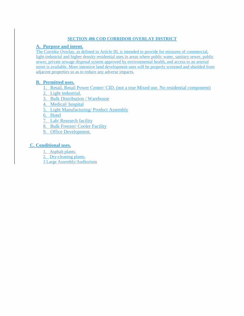
SECTION 406 COD CORRIDOR OVERLAY DISTRICT
A. Purpose and intent. The Corridor Overlay, as defined in Article III, is intended to provide for mixtures of commercial, light-industrial and higher density residential uses in areas where public water, sanitary sewer, public sewer, private sewage disposal system approved by environmental health, and access to an arterial street is available. More intensive land development uses will be properly screened and shielded from adjacent properties so as to reduce any adverse impacts. B. Permitted uses.
1. Retail, Retail Power Center/ CID. (not a true Mixed use. No residential component) 2. Light industrial. 3. Bulk Distribution / Warehouse 4. Medical/ hospital 5. Light Manufacturing/ Product Assembly 6. Hotel 7. Lab/ Research facility 8. Bulk Freezer/ Cooler Facility 9. Office Development.
C. Conditional uses. 1. Asphalt plants. 2. Dry-cleaning plants. 3 Large Assembly/Auditorium
ARTICLE XII. SUBDIVISION REGULATIONSAND COMMERCIAL DEVELOPMENT STANDARDS
PART I SUBDIVISION REGULATIONS
Section 1201. Short title.
This section shall be known and may be cited as the "Subdivision Regulations of Habersham County, Georgia."
Section 1202. Application, platting jurisdiction and enforcement. (A) Plats required: Since subdivisions require land disturbances and infrastructure development that affects
the residents of the county, financially, aesthetically and generally, any subdivider proposing to subdivide land shall submit plats of the proposed subdivision as set forth in Section 1208 and/or 1212.
(B) New work: No subdivider shall proceed with any construction work on a proposed subdivision before obtaining preliminary plat approval from the planning commission.
(C) Platting authority is as follows: 1. An exemption plat, as defined by Section 301 shall be reviewed, approved and marked for recording by the designated representatives of the planning department. 2. A preliminary plat, as defined in Section 301 shall be reviewed, approved and marked by the planning commission. 3. A final plat, as defined in Section 301, shall be reviewed, approved and marked by the planning commission.
Section 1203. Use of plat. (A) No final plat of a subdivision as set forth in Sections 1204 and 1212 shall be recorded in the office of the
clerk of the Superior Court of Habersham County unless it shall have the approval of the planning department or the planning commission written on said plat.
(B) No person shall sell or transfer or agree to sell any land by reference to or exhibition of or other use of a plat of a subdivision before that plat has been approved and marked in accordance with this appendix and recorded in the office of the clerk of the Superior Court of Habersham County. The description by metes and bounds in the instrument of transfer or other documents shall not exempt the transaction from such penalties.
(C) The filing or recording of a plat of a subdivision without the approval as required by this appendix shall be a misdemeanor. The planning commission and the governing body is authorized to levy charges for certain actions, inspections, and to cover certain direct costs. Such fees are to be used only to defray costs incurred by the planning commission when enforcing the provisions of Article XII.
Section 1204. Administrative plat approval. The following types of land subdivisions, transfers, and sales are specifically exempted from the preliminary
and final plat approval requirements of these regulations but shall be required to file an exemption plat meeting the requirements of Section 1212 with the planning department.
(A) The combination of portions of previously platted lots in an approved subdivision where the total number of lots is not increased and the resultant lots are equal to the standards of the county and no new roads or road location changes are involved;
(B) The creation and sale of cemetery plots; 23/20(C) The creation of leaseholds for space within a multiple-occupancy building or the division of property
into leaseholds (but not for sale) for commercial, industrial, or institutional use; (D) Subdivision of land as defined in Section 301; (E) Subdivision, family as defined in Section 301.
Section 1205. Subdivision of land and family subdivisions.
(A) Subdivision of land as defined in Section 301 is allowed and can be approved administratively if the following requirements are met: 1. Panhandle or flag lots shall be designed as specified in Section 1217 of this article unless terrain or geometry makes standard design or frontage impossible or impractical. 2. Minimum lot size is equal to that required by the district or minimum required by environmental health for septic tank or in compliance with the slope table of Section 1107, or whichever is greater. 3. Plats shall meet the applicable specifications for a final plat required in Section 1212.
(B) Family subdivisions are allowed and can be approved administratively if the following requirements are met:
1. Does not involve the creation of any new streets, public or private, or parcels intended to utilize any community water or sewer system.
(a) Up to four lots or dwellings may use a shared driveway as defined in section 301. When shared driveways are used the following statement shall be placed on the approved plat(s): "SOME DRIVES IN THIS SUBDIVISION ARE DESIGNATED PRIVATE AND WILL NOT BE ACCEPTED FOR MAINTENANCE BY HABERSHAM COUNTY." (b) Five lots or more must comply with the requirements stipulated in Section 1117. (c) Panhandles of 600 feet maximum may be allowed where terrain or geometry makes standard design or frontage impossible or impractical. (d) Minimum one acre lot or minimum required by environmental health for septic tank or in compliance with the slope table of Section 1107, whichever is greater. (e) A minimum setback of 35 feet from any easement or shared driveway on the front of the lot. Side and rear setbacks are determined by district requirements. (f) Plats shall meet the applicable specifications for a final plat required in Section 1212.
2. Ownership is limited to property transfers to immediate family members related by blood, by virtue of marriage and/or adoption. Transfer of property to immediate family members includes but is not limited to: spouse to spouse, parent to children, sibling to sibling, grand-parent to grand-children. Whenever a family subdivision is proposed, appropriate deeds and/or plats must be submitted to the planning department clearly stating the transfer of property from family member(s) to family member(s) so as not to circumvent any portion of this appendix.
If the plat complies with all applicable regulations, the administrative officer shall mark the plat as an approved family subdivision plat. If the exemption plat does not comply, the administrative officer shall not approve the plat unless it is modified to conform.
Provided, however, that such exemptions shall not require the county to issue permits if the resulting lot(s) fail(s) to meet any applicable provisions for lot size, lot width, access, or other dimensional requirements of this appendix, or any applicable provisions of this section.
Further subdivision of property for sale to or transfer to or development by other than a family member will subject this property to the requirements of Section 1207 and referenced sections.
Section 1206. Special Subdivisions. I. Conservation subdivision design option.
A. Purpose and intent. This section is intended to allow for the development of conservation subdivisions that cluster development and provide for preservation of open space, as an alternative to conventional subdivision development. This section is specifically intended:
1. To provide for the preservation of greenspace as a nonstructural stormwater runoff and watershed protection measure; 2. To provide a residential development option that permits flexibility of design in order to promote environmentally sensitive and efficient uses of the land; 3. To preserve in perpetuity unique or sensitive natural resources such as groundwater, floodplains, wetlands, streams, steep slopes, woodlands and wildlife habitat;
4. To permit clustering of houses and structures on less environmentally sensitive soils which will reduce the amount of infrastructure, including paved surfaces and utility easements, necessary for residential development; 5. To reduce erosion and sedimentation by minimizing land disturbance and removal of vegetation in residential development; 6. To promote interconnected greenways and corridors throughout the community; 7. To promote contiguous greenspace with adjacent jurisdictions; 8. To encourage interaction in the community by clustering houses and orienting them closer to the street, providing public gathering places and encouraging use of parks and community facilities as focal points in the neighborhood; 9. To encourage street designs that reduces traffic speeds and reliance on main arteries; 10. To promote construction of convenient landscaped walking trails and bike paths both within the subdivision and connected to neighboring communities, businesses, and facilities to reduce reliance on automobiles; 11. To conserve scenic views and reduce perceived density by maximizing the number of houses with direct access to and views of open space; and 12. To preserve important historic and archaeological sites.
B. General regulations. 1. Applicability of regulations. This design option is available as an alternative for the development of subdivisions that are served by public sewer or an approved private sewer system, as permitted by right in the LI, MI and HI districts. The applicant shall comply with all other provisions of the comprehensive land development resolution and all other applicable laws. 2. Ownership of development site. The tract of land to be subdivided may be held in single and separate ownership or in multiple ownership. If held in multiple ownership, however, the site shall be developed according to a single plan with common authority and common responsibility. 3. Housing density determination. The maximum number of lots in the conservation subdivision shall be determined by development of a "Yield Plan". In a "Yield Plan", a conventional subdivision design plan is prepared by the applicant, in which the tract of land is subdivided in a manner intended to yield the highest number of lots possible. The plan does not have to meet formal requirements for a site plan, but the design must be capable of being constructed given site features and the comprehensive land development resolution and all other applicable laws. 4. Minimum lot size. Once the maximum number of lots is determined through development of the "Yield Plan", a conservation subdivision layout is developed by meeting the requirements of this section. The minimum lot size in a conservation subdivision shall be 10,000 square feet or the area necessary to accommodate required water and waste disposal systems.
C. Application requirements. 1. Site analysis map required. Concurrent with the submission of a preliminary plat, the applicant shall prepare and submit a site analysis map. The purpose of the site analysis map is to ensure that the important site features have been adequately identified prior to the creation of the site design and that the proposed open space will meet the requirements of this section. The site analysis map shall include the following features:
(a) Property boundaries; (b) All streams, rivers, lakes, wetlands and other hydrologic features; (c) Topographic contours of no less than five-feet intervals for hilly terrain (slopes greater than ten percent), two feet intervals for rolling terrain (two percent to ten percent), and one foot for flat terrain (slopes less than two percent) as referenced in the comprehensive land development resolution; (d) All primary and secondary conservation areas labeled by type, as described in this section; (e) General vegetation characteristics; (f) General soil types;
(g) The planned location of protected open space; (h) Existing roads and structures; and (i) Potential connections with existing greenspace and trails.
2. Open space management plan required. An open space management plan, as described in this section shall be prepared and submitted prior to the issuance of a land disturbance permit. 3. Instrument of permanent protection required. An instrument of permanent protection, such as a conservation easement or permanent restrictive covenant, as described in this section shall be placed on the open space concurrent with the issuance of a land disturbance permit. 4. Other requirements. The applicant shall adhere to all other applicable requirements of the underlying zoning, the land development resolution, and all other applicable provisions of the Official Code of Habersham County, Georgia. 5. The configuration and location of the subdivision and the proposed open space are subject to approval of the administrative officer and planning commission, to ensure that the purposes and intent of this section are met by the application.
D. Open space. 1. Definition. Open space is the portion of the conservation subdivision that has been set aside for permanent protection. Activities within the open space are restricted in perpetuity through the use of an approved legal instrument. 2. Standards to determine open space.
(a) The minimum restricted open space shall comprise at least 40 percent of the gross tract area. (b) The following are considered primary conservation areas and are required to be included within the open space, unless the applicant demonstrates that this provision would constitute an unusual hardship and be counter to the purposes of this section:
i. The regulatory 100-year floodplain; ii. Buffer zones of at least 75-foot width along all perennial and intermittent streams; iii. Slopes above 25 percent of at least 5,000 square feet contiguous area; iv. Wetlands that meet the definition used by the Army Corps of Engineers pursuant to the Clean Water Act; v. Populations of endangered or threatened species, or habitat for such species; and, vi. Archaeological sites, cemeteries and burial grounds.
(c) The following are considered secondary conservation areas and should be included within the open space to the maximum extent feasible:
i. Important historic sites; ii. Existing healthy, native forests of at least one acre contiguous area: iii. Individual existing healthy trees greater than eight inches caliper, as measured at DBH; iv. Other significant natural features and scenic viewsheds such as ridge lines, peaks and rock outcroppings, particularly those that can be seen from public roads; v. Prime agricultural lands of at least five acres contiguous area; and vi. Existing trails that connect the tract to neighboring areas.
(d) Above-ground utility right-of-ways and small areas of impervious surface may be included within the protected open space but cannot be counted towards the 40 percent minimum area requirement (exception: historic structures and existing trails may be counted.) Large areas of impervious surface shall be excluded from the open space. (e) At least 75 percent of the open space shall be in a contiguous tract. The open space should adjoin any neighboring areas of open space, other protected areas, and non-protected natural areas that would be candidates for inclusion as part of a future area of protected open space. (f) The open space shall be directly accessible to the largest practicable number of lots within the subdivision. Non-adjoining lots shall be provided with safe, convenient access to the open space.
3. Permitted uses of open space. Uses of open space may include the following: (a) Conservation of natural, archeological or historical resources;
(b) Meadows, woodlands, wetlands, wildlife corridors, game preserves, or similar conservation-oriented areas; (c) Walking or bicycle trails, provided they are constructed of porous paving materials; (d) Active recreation areas, provided that they are limited to no more than ten percent of the total open space and are not located within primary conservation areas. Active recreation areas may include impervious surfaces. Active recreation areas in excess of this limit must be located outside of the protected open space; (e) Agriculture, horticulture, silviculture or pasture uses, provided that all applicable best management practices are used to minimize environmental impacts, and such activities are not conducted within primary conservation areas; (f) Nonstructural stormwater management practices; (g) Easements for drainage, access, and underground utility lines; or (h) Other conservation-oriented uses compatible with the purposes of this chapter.
4. Prohibited uses of open space. (a) Golf courses; (b) Roads, parking lots and impervious surfaces, except as specifically authorized in the comprehensive land development resolution; (c) Agricultural and forestry activities not conducted according to accepted best management practices; and, (d) Other activities as determined by the applicant and recorded on the legal instrument provided for permanent protection.
E. Ownership and management of open space. 1. Ownership of open space. The applicant must identify the owner of the open space who is responsible for maintaining the open space and facilities located thereon. If a Homeowners' Association is the owner, membership in the association shall be mandatory and automatic for all homeowners of the subdivision and their successors. If a Homeowners' Association is the owner, the Homeowners' Association shall have lien authority to ensure the collection of dues from all members. The responsibility for maintaining the open space and any facilities located thereon shall be borne by the owner. 2. Management plan. Applicant shall submit a plan for management of open space and common facilities ("plan") that:
(a) Allocates responsibility and guidelines for the maintenance and operation of the open space and any facilities located thereon, including provisions for ongoing maintenance and for long-term capital improvements; (b) Estimates the costs and staffing requirements needed for maintenance and operation of and insurance for, the open space and outlines the means by which such funding will be obtained or provided; (c) Provides that any changes to the plan be approved by the planning commissioners; and, (d) Provides for enforcement of the plan.
3. In the event the party responsible for maintenance of the open space fails to maintain all or any portion in reasonable order and condition, Habersham County, Georgia may assume responsibility for its maintenance and may enter the premises and take corrective action, including the provision of extended maintenance. The costs of such maintenance may be charged to the owner, Homeowners' Association, or to the individual property owners that make up the Homeowners' Association, and may include administrative costs and penalties. Such costs shall become a lien on all subdivision properties.
F. Legal instrument for permanent protection. 1. The open space shall be protected in perpetuity by a binding legal instrument that is recorded with the deed. The instrument shall be one of the following:
(a) A permanent conservation easement in favor of either: i. A land trust or similar conservation-oriented non profit organization with legal authority to accept such easements. The organization shall be bona fide and in perpetual existence and the
conveyance instruments shall contain an appropriate provision for retransfer in the event the organization becomes unable to carry out its functions; or ii A governmental entity with an interest in pursuing goals compatible with the purposes of this section.
If the entity accepting the easement is not Habersham County, Georgia, then a right of enforcement favoring Habersham County, Georgia, shall be included in the easement;
(b) A permanent restrictive covenant for conservation purposes in favor of a governmental entity; or, (c) An equivalent legal tool that provides permanent protection, if approved by Habersham County, Georgia.
2. The instrument for permanent protection shall include clear restrictions on the use of the open space. These restrictions shall include all restrictions contained in this appendix, as well as any further restrictions the applicant chooses to place on the use of the open space.
II. Planned developments (Reserved).
Section 1207. Procedures and requirements for approval of subdivision plats. A. Pre-application conference: Whenever a subdivision is proposed within Habersham County, the developer is urged to consult early with the administrative officer, their designee and/or the review committee. The developer may present sketch plans and data showing existing conditions within the site and in its vicinity and the proposed layout and development of the subdivision and request advice and guidance concerning the project and the administrative procedures involved. B. Sequence of administrative procedures: Listed below in normal sequential order are the generally occurring steps required to successfully complete development of a subdivision:
1. Pre-application conference with the administrative officer. For projects of unique design, a conceptual site drawing would aid in the conference. 2. Review online or purchase Habersham County Comprehensive Land Development Resolution for guidance in design. 3. Determine the public school district(s) and school(s) that will be necessarily impacted by the proposed subdivision. 4. Request the board of education determine the current student load and maximum capacity in each public school to be necessarily impacted by the proposed subdivision. 5. Consult with Habersham County Health Department to identify any possible water or sewage problems associated with the land proposed for subdividing. 6. Consult FIRM maps, historical flood data, county review staff and design professionals to ensure that land being developed does not propose building sites in flood plains, flood hazard areas and that natural waterways will not be interrupted. 7. Have land surveyed to obtain required data for plat submittal and to determine and detail natural features, such as topography and geometry, establish lot lines and other specifications required in this appendix. Submit the preliminary plat to the planning department at least 30 days prior to the next regular meeting of the planning commission with the following:
(a) A letter requesting review and approval of a preliminary plat and giving the name and address of a person to whom the notice of the hearing by the Planning Commission on the preliminary plat shall be sent. (b) Ten copies of the preliminary plat and other documents, as may be specified. (c) A preliminary plat filing fee shall be assessed as established in the fee schedule approved by the Habersham County Board of Commissioners. (d) A department of transportation letter is required at the preliminary plat stage if any new road or street is created that abuts/joins a state route. (e) A traffic study is required at the preliminary plat stage when any new road or street is created that abuts or joins a public street and serves one of the following:
i. A residential development of 25 lots or more or
ii. A commercial/industrial project creating more than 50 trips per day. Note to staff: Upon review of the preliminary plat by the planning department, all comments that need to be addressed shall be given to the applicant no later than three working days prior to the advertising deadline of next scheduled planning commission meeting. Each comment is to be referenced to the applicable section of code being commented upon.
8. Be prepared to accompany the planning department staff or a planning commission member to the development site prior to the next public hearing of the planning commission meeting. 9. Attend planning commission meeting at which preliminary plat approval is sought, or send competent representative with written authorization who can answer questions in your name. No action will be taken by the planning commission when no representative is present. 10. The planning commission shall review the preliminary plat at its public hearing. After staff presentation, the applicant shall have ten minutes to make a presentation and any opponents shall have ten minutes to speak. The planning commission may grant more time as necessary. 11. Prepare and submit to the planning department all documents required for a land disturbance permit. 12. Begin initial subdivision work. 13. Request inspection of earthwork, and utility work if any, by planning department prior to applying road surface material such as gravel or pavement and before seeding required by conditions of grading permit. 14. Complete survey work as needed. 15. Develop final plat for submission to HCPC. 16. Complete road, utility, and soil erosion work. 17. Request final planning department on-site inspection of completed required improvement work. 18. Submit final plat to planning department 30 days before meeting at which approval is sought. Plat must bear all required certificates noted in the appendix as well as all notations or changes specified by the planning commission when the preliminary plat was tentatively approved and the following:
(a) A letter requesting review and approval of a final plat and giving the name and address of the person to whom the notice of the hearing by the planning commission on the final plat shall be sent. (b) The required number of paper copies of the final plat and other documents, as may be specified; and reproducible(s) which are to be returned to the subdivider for filing. (c) A final plat fee shall be assessed as established in the fee schedule approved by the Habersham County Board of Commissioners. (d) A complete disclosure on how all utilities, roads and amenities are to be maintained, (including department of housing and urban development property report where appropriate) plus information requested as a result of findings during preliminary review. (e) A copy of all recorded covenants associated with the subdivision.
19. Attend planning commission meeting or send a competent representative with written authorization who can answer questions in your name. No action will be taken by the HCPC when no representative is present.
Section 1208. Preliminary plat specifications. The preliminary plat shall conform to the specifications contained in Appendix B.
Section 1209. Preliminary plat review. (a) The administrative officer or their designee shall check the plat for compliance with these and other relevant county regulations and ordinances and report findings and recommendations to the HCPC in public session. (b) No preliminary plat shall be reviewed by HCPC except in public session and advertised as required by Section 1207. Such sessions or hearings must be held at least monthly and are generally held on the third Tuesday of each month. The administrative officer is not empowered to act or speak for the HCPC in approving or disapproving preliminary plat requests. Not less than five days before the public hearing a
notice of the time and place of the hearing shall be sent by the administrative officer via registered or certified mail to the person designated in the letter requesting preliminary plat review. If personal telephone contact between these parties can be made before the five-day requirement, only regular mail follow-up is required. (c) HCPC shall not review the preliminary plat or hear public comments unless the applicant or a designated representative with written authorization is present at the hearing. If the applicant or approved representative is no in attendance, the 60 day requirement in subsection (f) below is automatically waived for an additional 61 days. (d) After conducting the public hearing as specified in subsection 1207(b) (11), the HCPC shall make one of the following decisions which shall be recorded in the minutes:
1. Approve the preliminary plat. 2. Approve the preliminary plat on condition that necessary modifications be made. Such required modifications must be recorded on the plat and in the minutes. 3. Disapprove the preliminary plat.
(e) If the HCPC approves the preliminary plat, it shall be noted by a certificate of preliminary plat approval (See Appendix A, Form 1) inscribed on two copies of the preliminary plat and distributed as follows: 1. One annotated copy of the plat shall be returned to the subdivider or agent; 2. One copy permanently filed in HCPC records.
(f) Plats not acted on by HCPC within 60 days of request for approval shall be deemed approved by the HCPC. If, however, HCPC determines that additional time is required to study a preliminary plat, an extension of time shall be requested in writing from the subdivider, who may agree to a specific time extension in lieu of a denial.
Section 1210. Parameters of preliminary plat approval. (a) All preliminary plat approvals shall be limited by these qualifications:
1. The approval is a tentative approval only, pending submission of a final plat. 2. The approval is valid for only one year from the issuance of a land disturbance permit or two years from the date of preliminary plat approval whichever is the lesser and shall be null and void after that date. If final plat approval is not received before the expiration of the preliminary plat a new preliminary plat application shall be required. 3. Exception: One extension of the land disturbance permit, for good cause shown and for a maximum time period not to exceed the life of the preliminary plat approval, may be granted when requested as follows:
i. In writing prior to the expiration of the preliminary plat approval and ii. Must be filed with the planning department. iii. The developer shall have the burden of proof and/or justification of a need for the extension.
(b) Preliminary plat approval does not constitute authorization for subdivider to begin physical improvement to the property being subdivided, but rather the authority to:
1. Prepare and submit road and infrastructure construction plans and 2. Erosion and sedimentation plans for approval and 3. To request land disturbance permit(s) and 4. All required permits to construct only one model house.
(c) Plats of developments within municipalities where the resolution has not been adopted shall have the following certificate attached:
"This plat of land within the city limits of _________ is not subject to regulation by the Habersham County Planning Commission."
(d) Major changes to preliminary plats necessitate that the plat be resubmitted to the planning commission for review and approval. No final plat will be approved that does not substantially comply to the approved preliminary plat. Major changes would be changing the street configuration, location of uses, number of lots, and similar changes.
Section 1211. Land disturbance permit application. The land disturbance permit application shall conform to and meet the specifications contained in [Article XII
of this appendix.]
Section 1212. Final plat specifications. The final plat shall conform to and meet the specifications contained in appendix B and contain the following:
(a) A surveyor's certification, directly on the final plat. See appendix A, Form 4. (b) An owner's certification, directly on the final plat. See appendix A, Form 5. (c) Certificate of dedication. See appendix B. (d) A certificate of approval of the final plat by the planning commission, directly on the plat, see appendix A, Form 3. (e) Copy of official action of governing body. A copy of the resolution adopted by the governing body accepting the streets, improvements, easements and any other property dedicated by the owner for public use as indicated on the final plat, shall be attached to the final plat within 45 days after action by the governing body.
Section 1213. Final plat review and approval. (a) The planning department staff shall check the plat for conformance with the approved/conditionally approved preliminary plat and for compliance with this and other relevant county regulations and ordinances and report their findings with their recommendation to the Habersham County Planning Commission in public session. The planning department, upon review of the final plat, shall notify the applicant of any comment that needs to be addressed no later than ten working days prior to the next scheduled planning commission meeting. Each comment shall be referenced to the applicable section of code being commented upon. (b) No final plat shall be acted upon by the Habersham County Planning Commission except in public session. Such sessions or hearings must be held at least monthly and are generally held on the third Tuesday of each month. The administrative officer is not empowered to act or speak for the Habersham County Planning Commission in approving or disapproving final plat requests. (c) Not less than five days before the public hearing, notice of the time and place of the hearing shall be sent by the administrative officer via registered or certified mail to the person designated in the request for final plat approval or if personal contact between these parties can be made by telephone before the five-day requirement, only regular mail follow-up is required. (d) The Habersham County Planning Commission shall take no action on a final plat if the applicant or a designated representative is not present at the hearing, in which case the 45-day requirement in subsection (g) below is automatically waived for 46 days. (e) At a public hearing, conducted under the procedures of subsection 1207(B) (11), within 45 days of request for final plat approval, the Habersham County Planning Commission shall take one of the following actions which shall be recorded, with reasons for disapproval where appropriate, in the minutes:
1. Approve the final plat. 2. Disapprove the final plat and further notify the subdivider in writing of the specific reasons for disapproval within five days.
(f) In order for the Habersham County Planning Commission to approve a final plat, all requirements of these regulations must have been satisfied, and all improvements required must have been completed not less than five workdays prior to the scheduled hearing at which final plat approval is requested. All improvements shall be inspected by HCPC. No final plat will be approved that does not substantially comply to the approved preliminary plat. (g) Plats not acted on by the Habersham County Planning Commission within 45 days of a request for approval, shall be deemed approved and a certificate of final plat approval shall be issued on request of the subdivider. If, however, the Habersham County Planning Commission determines that additional time is required to study a final plat, an extension of time shall be requested in writing from the, applicant or their duly authorized agent who may agree to a specific time extension in lieu of a plat disapproval.
(h) If final plat approval is requested two times and is denied both times because required improvements have not been made, the Habersham County Planning Commission shall not further consider that plat for 90 days following date of the second disapproval. (i) When all conditions for approval of the final plat have been met and such approval has been granted, the Habersham County Planning Commission shall endorse and date the certificate of final plat approval on the original copy of the final plat. Such approval and endorsement convey the authority to record the plat and to sell lots shown on the plat. (j) Upon approval of a final plat, the chairman of the planning commission or his designated representative shall have the final plat recorded in the office of the Clerk of the Superior Court of Habersham County. The subdivider shall be responsible for the payment of the recording fee at the time of submitting the final plat.
Section 1214. Reserved. Section 1215. General design and other requirements.
(a) Suitability of the land. Land subject to flooding, improper drainage, or erosion or that is for topographical or other reasons unsuitable for residential use that will contribute to danger to health, safety, or property destruction, unless the hazards can be and are corrected. No land determined to fall in a 25-year flood plain identified by state or federal authority shall be approved for any building site. All land falling into the 100-year flood zone must be so identified on the preliminary and final plats. (b) Name of subdivision. The name of the subdivision must have approval of the planning commission. The name shall not duplicate or closely approximate the name of an existing subdivision in the county. (c) Conformance to adopted major thoroughfare and other plans. All streets and other features of the major thoroughfare plan of Habersham County, Georgia, shall be platted by the subdivider in the location and to the dimension indicated on the major thoroughfare plan. When features of other plans such as schools or public building sites, parks, or other land for public uses are located in whole or in part in a land subdivision, such features shall be either dedicated or reserved by the subdivider for acceptance or acquisition within a reasonable time by the appropriate public agency. Whenever a plat proposes the dedication of land to public use that the planning commission finds not required or suitable for such public use, the planning commission shall refuse to approve the plat, and shall notify the governing body of the reasons for such action. (d) Special easements. Easements having a minimum width of 12 feet and located along the side or rear lot lines shall be provided, as required for utility lines, underground mains, and cables. Where a watercourse, drainageway, channel or stream traverses a subdivision, there shall be provided a storm-water or drainage right-of-way of adequate width, parallel to streets. When suitable road shoulder slopes cannot be obtained within prescribed road right-of-way widths, slope easements shall be required on abutting lots.
Section 1216. Reservation of public sites and open spaces. (Figure 2) (a) Where the features of the comprehensive plan, such as school sites, parks, playgrounds and other public spaces are located in whole or in part in a proposed subdivision, such features shall be reserved by the subdivider, provided, however, that no more than ten percent of the total area of the subdivision shall be required for reservation to fulfill the requirements of this section. Whenever the land required for such planned features is not dedicated to and accepted, purchased, acquired, optioned, or condemned by the appropriate public agency within a two-year period from the date of recording the subdivision plat or by the time that at least 75 percent of the lots are built on and occupied, whichever is sooner, the subdivider may claim the original reservation and cause it to be subdivided in a manner suitable to the subdivider, subject to the provisions of this appendix. Whenever the public body responsible for land acquisition executes a written release stating that the reserved land is not to be acquired, the planning commission shall waive the reservation requirements. When a development is of such size or of a nature which will have a significant impact on community facilities, the dedication of an appropriate amount of land to meet such needs may be required by the planning commission.
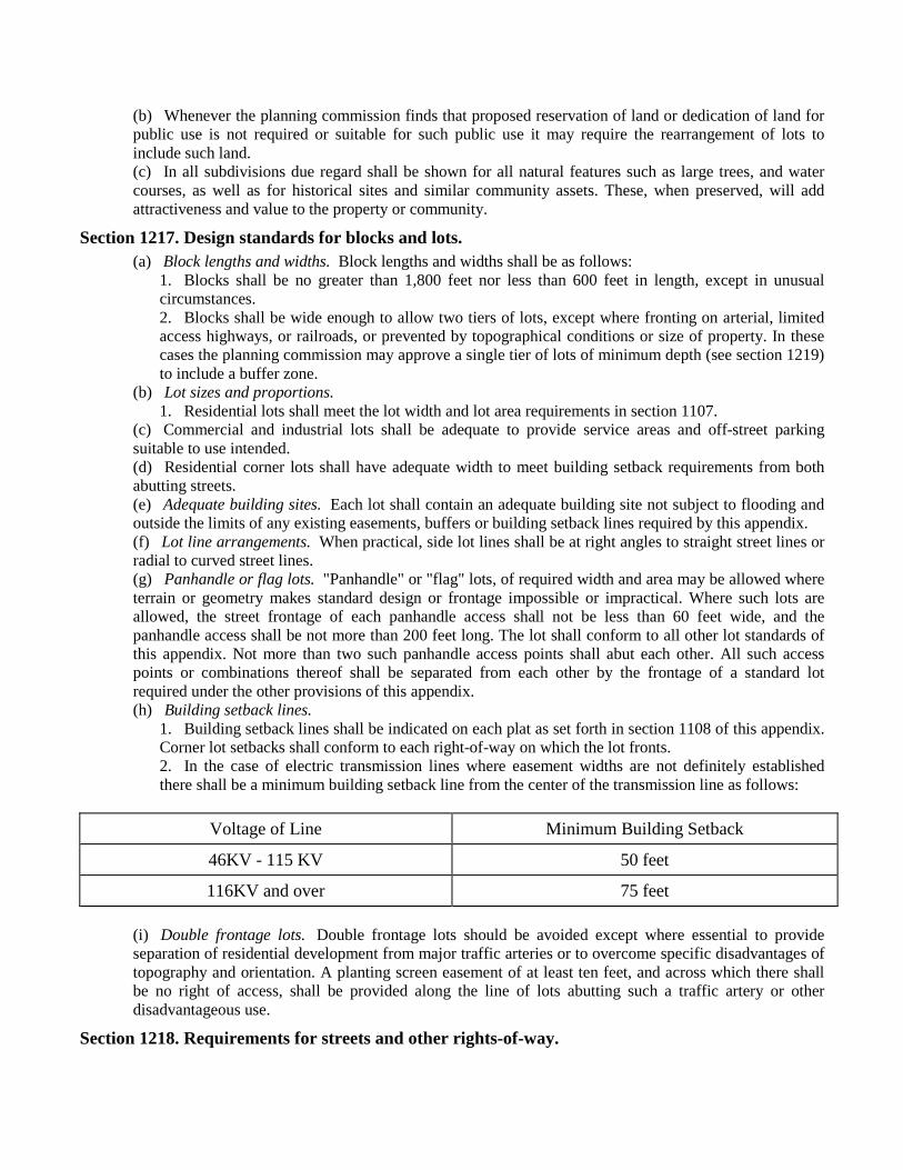
(b) Whenever the planning commission finds that proposed reservation of land or dedication of land for public use is not required or suitable for such public use it may require the rearrangement of lots to include such land. (c) In all subdivisions due regard shall be shown for all natural features such as large trees, and water courses, as well as for historical sites and similar community assets. These, when preserved, will add attractiveness and value to the property or community.
Section 1217. Design standards for blocks and lots. (a) Block lengths and widths. Block lengths and widths shall be as follows:
1. Blocks shall be no greater than 1,800 feet nor less than 600 feet in length, except in unusual circumstances. 2. Blocks shall be wide enough to allow two tiers of lots, except where fronting on arterial, limited access highways, or railroads, or prevented by topographical conditions or size of property. In these cases the planning commission may approve a single tier of lots of minimum depth (see section 1219) to include a buffer zone.
(b) Lot sizes and proportions. 1. Residential lots shall meet the lot width and lot area requirements in section 1107.
(c) Commercial and industrial lots shall be adequate to provide service areas and off-street parking suitable to use intended. (d) Residential corner lots shall have adequate width to meet building setback requirements from both abutting streets. (e) Adequate building sites. Each lot shall contain an adequate building site not subject to flooding and outside the limits of any existing easements, buffers or building setback lines required by this appendix. (f) Lot line arrangements. When practical, side lot lines shall be at right angles to straight street lines or radial to curved street lines. (g) Panhandle or flag lots. "Panhandle" or "flag" lots, of required width and area may be allowed where terrain or geometry makes standard design or frontage impossible or impractical. Where such lots are allowed, the street frontage of each panhandle access shall not be less than 60 feet wide, and the panhandle access shall be not more than 200 feet long. The lot shall conform to all other lot standards of this appendix. Not more than two such panhandle access points shall abut each other. All such access points or combinations thereof shall be separated from each other by the frontage of a standard lot required under the other provisions of this appendix. (h) Building setback lines.
1. Building setback lines shall be indicated on each plat as set forth in section 1108 of this appendix. Corner lot setbacks shall conform to each right-of-way on which the lot fronts. 2. In the case of electric transmission lines where easement widths are not definitely established there shall be a minimum building setback line from the center of the transmission line as follows:
Voltage of Line Minimum Building Setback
46KV - 115 KV 50 feet
116KV and over 75 feet
(i) Double frontage lots. Double frontage lots should be avoided except where essential to provide separation of residential development from major traffic arteries or to overcome specific disadvantages of topography and orientation. A planting screen easement of at least ten feet, and across which there shall be no right of access, shall be provided along the line of lots abutting such a traffic artery or other disadvantageous use.
Section 1218. Requirements for streets and other rights-of-way.
(a) Continuation of existing streets. Existing streets shall be continued at the same or greater width, but in no case less than the required width. (b) Street names. Proposed streets that are obviously in alignment with others already existing and named, shall bear the names of existing streets. In no case shall the name for proposed streets duplicate existing street names, regardless of the use of the suffix street, avenue, boulevard, drive, place, way, or court. Through its index list of street names on file the planning commission can assist the subdivider in avoiding duplication. (c) Street jogs. Street jogs with centerline offsets of less than 125 feet shall not be permitted. (d) Cul-de-sacs or dead-end streets.
1. Minor streets or courts designed to have one end permanently closed shall serve no more than 25 lots per block and have a turn-around or cross street every 1,000 feet unless necessitated by topography. They shall be provided with a turnaround at the closed end. 2. Where in the opinion of the platting authorities, it is desirable to provide street access to adjoining property, streets shall be extended to the boundary of such property and provided with a temporary turnaround.
(e) Single entry road restriction. In no case shall more than 100 lots in any subdivision be dependent on a single road or interval of road for entry/exit to/from the subdivision.
PART II. ROADWAYS, STREETS, AND RIGHT-OF-WAY STANDARDS
Section 1219. Development along major thoroughfares, limited access highway or railroad right-of-way.
Conditions and standards for land development within Habersham County shall be assigned in accordance with the type of road or street access provided to the properties. All roadways within the county shall be classified based according to Georgia Department of Transportation and Federal Highway Administration guidelines. The classifications shall be outlined within the County’s Comprehensive Plan and updated at a minimum of every five years.
(a) Lots shall have no access to an arterial road, expressway or other limited access highway but only to rural minor access or residential streets. Where a subdivision abuts or contains an arterial, a limited access highway or a railroad right-of-way, the platting authorities shall require street approximately parallel to and on each side of such right-of-way either as a marginal access street or at a distance suitable for an appropriate use of the intervening land, with a ten-foot non-access reservation suitably planted. Due regard should be given requirements for approach grades and future grade separations in determining distances (b) Alleys. Alleys may be required at the rear of all lots used for multi-family, commercial, or industrial developments but shall not be provided in one and two family residential developments unless the subdivider provides evidence satisfactory to the platting authorities of the need for alleys. (c) Street right-of-way and roadway pavement widths. The right-of-way width shall be the distance across a street from property line to property line. All subdivision streets, public or private, shall be platted as right-of-way streets. Lots shall not include any portion of the right-of-way. All streets shall be evaluated according to performance within specific site requirements or limitations. No street shall be platted on the basis of a private easement. (d) Minimum street right-of-way widths shall be as follows:
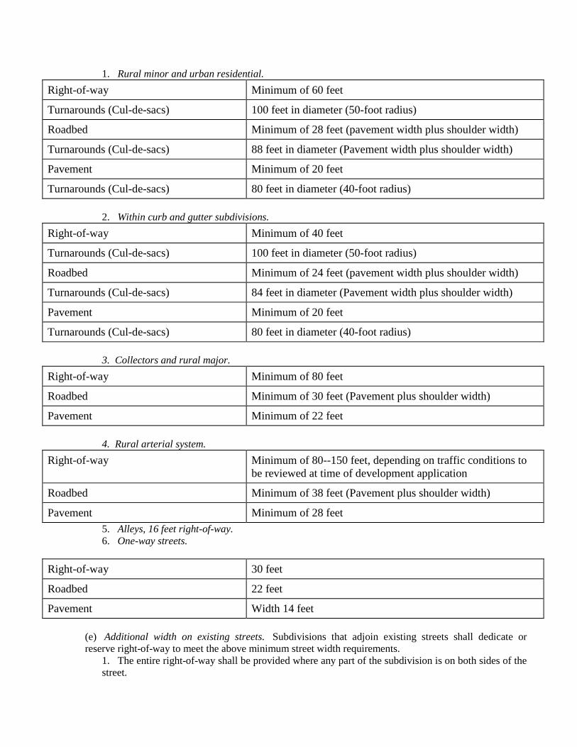
1. Rural minor and urban residential. Right-of-way Minimum of 60 feet
Turnarounds (Cul-de-sacs) 100 feet in diameter (50-foot radius)
Roadbed Minimum of 28 feet (pavement width plus shoulder width)
Turnarounds (Cul-de-sacs) 88 feet in diameter (Pavement width plus shoulder width)
Pavement Minimum of 20 feet
Turnarounds (Cul-de-sacs) 80 feet in diameter (40-foot radius)
2. Within curb and gutter subdivisions. Right-of-way Minimum of 40 feet
Turnarounds (Cul-de-sacs) 100 feet in diameter (50-foot radius)
Roadbed Minimum of 24 feet (pavement width plus shoulder width)
Turnarounds (Cul-de-sacs) 84 feet in diameter (Pavement width plus shoulder width)
Pavement Minimum of 20 feet
Turnarounds (Cul-de-sacs) 80 feet in diameter (40-foot radius)
3. Collectors and rural major. Right-of-way Minimum of 80 feet
Roadbed Minimum of 30 feet (Pavement plus shoulder width)
Pavement Minimum of 22 feet
4. Rural arterial system. Right-of-way Minimum of 80--150 feet, depending on traffic conditions to
be reviewed at time of development application
Roadbed Minimum of 38 feet (Pavement plus shoulder width)
Pavement Minimum of 28 feet 5. Alleys, 16 feet right-of-way. 6. One-way streets.
Right-of-way 30 feet
Roadbed 22 feet
Pavement Width 14 feet
(e) Additional width on existing streets. Subdivisions that adjoin existing streets shall dedicate or reserve right-of-way to meet the above minimum street width requirements.
1. The entire right-of-way shall be provided where any part of the subdivision is on both sides of the street.
2. When the subdivision is located on one side of an existing street, one-half of the required right-of-way, measured from the centerline of the existing roadway, shall be provided.
(f) Street grades. Maximum and minimum street grades shall be as follows: 1. Rural arterial, not in excess of ten percent. 2. Rural major and collector streets, not in excess of 12 percent. 3. Rural minor routes, residential streets and alleys, not in excess of 16 percent. 4. No more than 25 percent of the total square feet of pavement within a subdivision may be applied to a grade of 12 to 16 percent. 5. No street grade shall be less than one-half of one percent in cases where streets are curbed and guttered. 6. In meeting these grade and slope requirements on steep terrain, the planning commission suggests wherever feasible that the developer utilize a divided roadway in which the lanes for travel in opposite directions are cut at different levels of elevation. Under certain conditions, this method of giving separate treatment to each travel lane would lessen cut and fill requirements. Median cuts would be used at points where both lanes have the same roadway grade. The median cuts would shorten distance of traveling any one direction and facilitate access to lots served by each lane.
(g) Horizontal curvature. The minimum radii of centerline curvature shall be as follows: 1. Arterial streets, as indicated on the road classification map, but in no case less than 800 feet. 2. Collector and rural major streets, 300 feet. 3. Rural minor and residential streets and alleys and other lower classification rural roads (industrial/commercial access, agricultural access, recreation and scenic, resource recovery), 100 feet. 4. Exceptions may be granted based on proven performance for special site requirements.
(h) Tangents. Between reverse curves, there shall be tangent having a length not less than the following:
1. Minor arterial streets, not less than 200 feet. 2. Collector and rural major streets, 100 feet. 3. Rural minor, residential streets and alleys and other lower classification rural roads (industrial/commercial access, agricultural access, recreation and scenic, and resource recovery), 25 feet.
(i) Vertical alignment. Vertical alignment shall be such that the following requirements are met: 1. Rural arterial streets shall have a sight distance of at least 500 feet at four feet above ground level. (10 × the speed limit or 10 × the algebraic distance, per DOT/AASHTO.) 2. Rural major and collector streets shall have a sight distance of at least 200 feet at four feet above ground level. 3. Rural minor, residential streets and alleys and other lower classification rural roads (industrial/commercial access, agricultural access, recreation and scenic, and resource recovery) shall have a sight distance of at least 100 feet at four feet above ground level. 4. Rural arterial streets shall have a sight distance of at least 500 feet at four feet above ground level. 5. Local rural routes, 75 feet at four feet above ground level.
(j) Street intersections. Street intersections shall be as nearly at right angles as possible. No street inter-section shall be at an angle of less than 75 degrees, unless required by unusual circumstances. (k) Curb-line radii. Property lines at street intersections shall be rounded with a curb radius of 20 feet. Where the angle of intersection is less than 75 degrees, the platting authorities may require a greater radius. The platting authorities also may permit comparable cut-offs or chords in place of rounded corners. (l) Steep slope development. Street alignments are subject to performance standards as are appropriate to Habersham County and state construction requirements as may be adjusted to any given site limitations. Driveways and roads coming into a county road shall observe at a minimum a 25-foot deep area, with a slope of no more than two percent, at the intersection with the county right-of-way. No storm water shall
run out onto the county road from a subdivision or individual lot or parcel. Stormwater runoff coming from driveways shall be diverted into ditches and away from the county road.
Section 1220. Development/project access improvements. Single-family detached, single-family attached, duplex residential subdivisions, multi-family and non-residential development.
When property that abuts upon an existing or proposed county road is to be developed or redeveloped as a single-family detached or duplex subdivision, multi-family and non-residential development and the county road will provide access to the property, access improvements to the county road (turn lanes, etc.) shall be provided by the developer as provided herein:
1. Design criteria shall be in accordance with the requirements of this document or the latest edition of the Georgia Department of Transportation's "Regulations for Driveway and Encroachment Control", 2. A right turn deceleration lane shall be required at each subdivision of 25 lots or more and commercial or private industrial project creating more than 50 trips per day with a road/street intersecting with a public road. Right turn deceleration lanes shall have a minimum length of 150 feet with an additional 50 feet taper length. Pavement width shall be 12 feet (exclusive of curb and gutter) if curb and gutter is required. The design thickness of the base and pavement structure shall include eight-inch compacted graded aggregate base course, four-inch compacted asphalt concrete binder and two-inch compacted asphalt concrete "E" of "F" surface course. Additional right-of-way, if required, to accommodate the right turn deceleration lane and shoulder width to match the existing county road (in no case less than a four-foot wide shoulder) shall be acquired and dedicated by the developer to Habersham County at no cost. Associated drainage improvements as deemed necessary by the construction of the right turn deceleration lane shall be required. 3. In the event a developer desires to construct a median break to serve the subdivision, a left turn lane leading to the median break shall be required to be provided by the developer and shall meet the standards contained in the GDOT" standards specifications manual" and "Regulations for Driveway and Encroachment Control", current editions. 4. Other access improvements may be required by the county upon the recommendation of either GDOT or the county engineer in order to ensure adequate site access, pedestrian access, convenience and safety to the motoring public. 5. The developer shall be responsible for the relocation of public or private utilities and drainage structures as may be occasioned by the required access improvements. 6. Subdivision street intersections with county maintained roads shall be located to provide adequate sight distance. Minimum intersection sight distances are criteria provided in Table (A). The line of sight establishes the boundary of a sight triangle within which there should be no sight obstruction between the heights of 30 inches and 108 inches. No plants or shrubs shall be planted in this area that grows to a height greater than 30 inches. The sight distance criteria are based on the average time required for a vehicle to make a left or right turn from a stop controlled approach to the public road (AASHTO Case B1 and B2). The time to execute the maneuver is based on recommendations contained in NCHPR Report 383, Intersection Sight Distance. The sight distances, for a two lane road are the distance traveled at the posted speed limit during the average of 6.5 and 7.5 seconds. See ASSHTO Green Book, chapter 9 Intersections, for adjustments due to grades greater than three percent and design vehicle other than passenger cars. The developer's engineer shall certify that sight distance requirements are in accordance with table (A), and so state on the preliminary plans at the time of submittal.
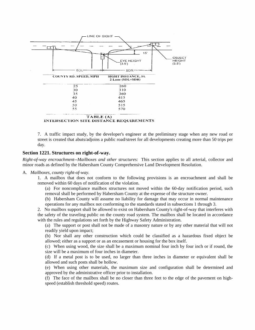
7. A traffic impact study, by the developer's engineer at the preliminary stage when any new road or street is created that abuts/adjoins a public road/street for all developments creating more than 50 trips per day.
Section 1221. Structures on right-of-way. Right-of-way encroachment--Mailboxes and other structures: This section applies to all arterial, collector and minor roads as defined by the Habersham County Comprehensive Land Development Resolution.
A. Mailboxes, county right-of-way. 1. A mailbox that does not conform to the following provisions is an encroachment and shall be removed within 60 days of notification of the violation.
(a) For noncompliance mailbox structures not moved within the 60-day notification period, such removal shall be performed by Habersham County at the expense of the structure owner. (b) Habersham County will assume no liability for damage that may occur in normal maintenance operations for any mailbox not conforming to the standards stated in subsections 1 through 3.
2. No mailbox support shall be allowed to exist on Habersham County's right-of-way that interferes with the safety of the traveling public on the county road system. The mailbox shall be located in accordance with the rules and regulations set forth by the Highway Safety Administration.
(a) The support or post shall not be made of a masonry nature or by any other material that will not readily yield upon impact; (b) Nor shall any other construction which could be classified as a hazardous fixed object be allowed; either as a support or as an encasement or housing for the box itself. (c) When using wood, the size shall be a maximum nominal four inch by four inch or if round, the size will be a maximum of four inches in diameter. (d) If a metal post is to be used, no larger than three inches in diameter or equivalent shall be allowed and such posts shall be hollow. (e) When using other materials, the maximum size and configuration shall be determined and approved by the administrative officer prior to installation. (f) The face of the mailbox shall be no closer than three feet to the edge of the pavement on high-speed (establish threshold speed) routes.
3. Multiple mailbox installations shall meet the same criteria as single mailbox installations. Multiple support installations should have their supports separated a minimum distance equal to three-fourths of their heights above ground. This will reduce interaction between adjacent mailboxes and supports.
B. Mailboxes--Subdivision roads with low traffic volume and speed. A mailbox that does not conform to the following provisions is an encroachment and shall be removed within 60 days of notification of the violation
1. Subdivision roads with low traffic volume and speed, shall comply with the following standard: (a) The supporting structure shall be as described in subsection 1221(A)2 above. (b) The face of the mailbox shall be no closer than two feet to the edge of the pavement or one foot from the back of the curb.
2. In the event that a request is made to place a subdivision road in the county maintenance system all existing structures on right-of-way shall be brought into compliance with section 1221 of this appendix.
C. Mailboxes--Existing structures on county maintained roads: Single-entrance subdivision roads with a rural minor road classification that have existing brick or masonry mailbox structures will be allowed so long as they meet the following requirements:
1. No portion of the mailbox or its structure shall be closer than two feet to the edge of pavement or one foot from the back of the curb. 2. The planning commission reserves the right to review all existing mailbox structures on a case-by-case basis as requested. 3. All undeveloped lots within a subdivision on a single entrance, low volume and low speed road shall conform to the specifications for mailbox structures defined in subsection 1221(A)2 above.
D. Other structures. 1. Masonry or other type vertical walls that create a hazard will not be allowed on county rights-of-way. Existing masonry or other type walls built on driveways in the right-of-way will comply with the following regulation:
(a) Single entrance subdivision roads with a rural minor road classification that have existing brick, rubble, or masonry driveway headwalls will be allowed so long as they meet the following requirements:
i. The wall shall not come within four and one-half feet of the edge of pavement. ii. The wall shall not extend above the existing driveway height without having adequate drain
holes through the wall. iii. The overall height shall not exceed 12 inches above the driveway surface. iv. All undeveloped lots within a subdivision on a single entrance, low volume, low speed road
shall conform to these same specifications. (b) Subdivision entrances with elaborate cosmetic structures of brick, masonry or other materials forming an island shall conform to the following:
i. No structure shall extend beyond the right-of-way line of the adjoining street. ii. No structure shall extend vertically to a height that would impair visibility of adjacent vehicle traffic. iii. Structure walls must not lean or protrude over the adjacent pavement so as to hinder resurfacing or maintenance of the surface. iv. No structure shall be placed in conflict with utility facilities. v. Structures placed in the middle of the cul-de-sac shall conform to all of the above specifications. vi. All structures must have some type of approved reflective device or be lit. vii. Any damage to existing structures during routine maintenance of the street will be the liability of the property owner.
(c) Exemption for new construction. Masonry or other type vertical walls may be built on driveways that are located in a platted subdivision on a "rural minor" road, defined herein and classified as a low volume, low speed, residential road that primarily serves the residents of the subdivision. A subdivision road or
street that may be used as a cut through or connector road to a main road may not be considered a "minor" road. These structures must conform to the regulations as stated in this section. Habersham County does not accept maintenance responsibility for these vertical wall structures. The planning commissioners reserve the right to review all structures on a case-by-case basis as requested.
E. Enforcement. 1. Existing structures. It shall be the responsibility of the public works director to enforce the provisions of this section as it relates to existing structures. The public works director shall notify, in writing, property owners found to be in violation of this section. If the property owners fail to remove the structures(s) in violation within the time allowed by this section, the public works director is authorized to issue a citation to the property owner stating the nature of the violation, the cost to the property owner for removal and the time and date the matter will be reviewed by the board of commissioners. A copy of the citation shall be sent to the chief building inspector. The public works director shall refer the citation to the board of commissioners at its earliest regularly scheduled meeting. The board shall review the facts and if the property owner is found in violation, the public works director shall be authorized and directed to remove structures in violation and to bill the property owner the cost of removal. 2. Enforcement (new construction). It shall be the responsibility of the chief building inspector to enforce the provisions of this section as it relates to all new construction. In addition, the chief building inspector is directed and authorized to deny any and all construction permits for any property or to any property owner with a structure(s) in violation of this section as cited by the public works director.
Section 1222. Required improvements. A. Performance and specifications. Every subdivider shall be required to make the improvements outlined in this article in accordance with the specifications herein or otherwise adopted by Habersham County. The necessity for storm drainage on each site will be determined by inspection. B. Monuments. Monumentation shall be done as required by Georgia State Rules Section 108-7-05. C. Grading. All streets, roads, and alleys shall be graded by the subdivider so that pavements and sidewalks, where required, can be constructed to the required cross section. The minimum width of grading shall be the pavement width as specified in section 1219, plus eight feet on each side. Deviation from the above will be allowed only when due to special topographical conditions.
1. Preparation: Before grading is started, that part of the right-of-way consisting of the area to be paved plus the shoulders shall be first cleared of all stumps, roots, brush and other objectionable materials and all trees not intended for preservation. 2. Cuts: All boulders and other obstructions shall be removed to a depth of two feet below the subgrade. Rock, when encountered, shall be scarified to a depth of 18 inches below the subgrade. All vegetative debris, to include tree stumps and roots must be removed from the site or may be burned in its entirety on site if burning complies with state rules and regulations. 3. Fill: All suitable material from roadway cuts may be used in the construction of fills, approaches, or at other places as needed. Excess materials, including organic materials, soft clays, etc., shall be removed from the roadway. The fill shall be spread in layers not to exceed six inches loose and compacted by a sheepsfoot roller. The filling of utility trenches and other places not accessible to the roller shall be mechanically tamped. 4. Subgrade: The subgrade shall be properly shaped, rolled and uniformly compacted to conform to the lines, grades, and typical cross-sections as shown on drawings approved by the planning commission. Unsuitable materials shall be excavated and replaced with acceptable compacted material.
D. Stormwater management plan. This section is to formulate a plan to manage stormwater runoff so that stormwater hazards are not created and existing runoff-related problems are not exacerbated, either upstream or downstream from or within the boundaries of the development. The stormwater management plan will consist of a stormwater report and construction documents (if applicable) to meet the minimum requirements set forth in this section.
1. A stormwater management plan shall be submitted with the request for land disturbance permit stage and shall contain the following information:
a. Location of proposed drainage-ways, streams and sediment ponds within the development. b. Location, size, and invert elevations of proposed drainage structure including culverts, bridges, pipes, drop inlets and top elevations of headwalls, diversion ditches, etc. c. Area of land contributing runoff to each drainage feature. d. Location of easements and right-of-way for drainage ways and maintenance accesses therefore. e. Typical improvement around drainage features and culverts, if any. f. Direction of waterflow throughout the subdivision and computed velocities at those points deemed necessary by the review agency staff. g. Detailed engineering drawings on all impoundment structures, dams, sediment ponds, etc.
2. A stormwater management plan must be prepared for new development or redevelopment to any site that meets one or more of the following criteria:
a) A new development in which 5,000 square feet or greater of new impervious area is created or that involves the land disturbing activity of one acre of land or greater. b) Land development activity on a redevelopment site that constitutes more than 50 percent of the site area for the entire site or increases the impervious area on site by more than 5,000 square feet. c) Any commercial or industrial development. (All commercial and industrial developments must have at least one storm water management facility).
3. The following development activities may be exempt from a stormwater management plan: a) Developments that do not create the addition of 5,000 square feet of impervious surfaces or disturb more than one acre of land. b) Individual single-family residential lots. (Single-family lots that are part of a subdivision or phased development project are not exempt.) c) Additions or modifications to existing single-family structures. d) Agricultural and silvicultural construction is exempt.
E. Stormwater report: A storm water hydrology report shall be provided to ensure that the requirements and criteria in these regulations are being complied with and that opportunities are being taken to minimize post-development stormwater runoff impacts from the development. The stormwater hydrology report shall identify the locations and quantities of stormwater runoff entering and exiting the site for both existing and developed conditions. The report at a minimum shall consist of pre and post developed topographic drainage maps delineating study points, drainage basins, soil types, runoff coefficients/curve numbers and land cover. In addition the report shall contain: a brief narrative, a vicinity map, a chart summarizing the water runoff associated with the proposed development and supporting design calculations for any proposed stormwater management facility (such as and including stage-storage or outlet rating curves and inflow and outflow hydrographs, pre and post developed hydrographs). Pond discharge locations shall be in defined drainage ditches or piped systems. If this is not possible the hydrology report shall address the creation of concentrated flows where none had occurred previously. The design professional shall ensure that the addition of any stormwater management facility within its watershed basin does not adversely affect down stream property owners or storm water drainage systems and structures. Stormwater hydrology reports shall be conducted in accordance with the criteria established in this section and must be submitted with the stamp and signature of a professional engineer (PE) or a registered land surveyor (RLS) licensed in the State of Georgia. F. Stormwater management facilities: Stormwater management facilities shall be implemented to control post-developed stormwater runoff. The facility shall be designed so that the peak release rates (when combined with all detention bypass areas) are equal to or less than the pre developed runoff rates at the same location. The facility will be designed to control the two to 50-year storm events. The facility shall also provide the safe passage of the 100-year storm event while providing one foot of free board between the 100-year pond elevation and the top of the dam. A proposed storm water management facility must be accompanied by a set of construction documents, signed by a design professional, depicting the location and layout of the proposed facility and provide details for the construction of the facility (ex. outlet structures, dams, positive drainage other structural controls, etc.) All stormwater facilities shall be enclosed by fencing and an access gate where the sides of the facility adjacent to the water are steeper than 3:1 and the depth of the water in the pond is greater than three feet. The owner of the property on which the facility is located shall be responsible for maintaining all stormwater management
facilities. A clean-out marker showing tow-thirds volume level of the pond shall be designated on the outlet structure to facilitate in inspection of the facility. If it is determined that the facility is not hydraulically functioning as designed, due to inadequate maintenance, the county may conduct inspections and maintenance on the facility and the owner will be responsible for all expenses involved. A 25-foot easement measured from the elevation of the 100-year storm event within the facility and a 25-foot access easement to the facility shall be provided to the county. The county shall notify the owner 24 hours prior to any inspection or maintenance work which involves accessing the easement. All stormwater management facilities shall be designed in accordance with the criteria established in this section and plans and reports must be submitted with the stamp and signature of a professional engineer (PE) licensed in the State of Georgia.
1. The following may be exempt from storm water management facilities but must provide a hydrology report:
a) A residential subdivision that does not increase the runoff for the two to 50-year storm event by more than 0.1 cubic feet per second per acre. Designated open space areas, flood plains, wetlands, green space, and any other areas that are not buildable, with an exemption for stream or creek buffers, may not be included in the hydrological analysis in determining if the subdivision meets this exemption. In addition the lot sizes must be uniformly sized throughout the subdivision development. b) Where development does not increase the stormwater runoff by more than one cubic feet per second (cfs) for the two to 50-year storm event.
2. Stormwater conveyance pipes: All culverts, cross drain, storm sewers or other drainage facilities under the county's jurisdiction shall be designed to accommodate all runoff from its entire upstream drainage area and be based upon the 50-year storm event. 3. An adequate drainage system, including necessary open ditches, pipes, culverts, intersectional drains, drop inlets, bridges, etc., shall be provided for the proper drainage of all surface water. Cross-drains shall be provided to accommodate all natural waterflow, and shall be of sufficient length to permit full width roadway (roadway is defined as the portion of a road or street within the limits of construction) and the required slopes. The culvert pipe size to be provided shall be determined based on an engineering study. In no case shall the pipe diameter for cross drain pipe be less than 18 inches. Side drain pipe (driveway, etc.) shall not be less than 15 inches in diameter.
a. All pipe used for cross drains shall consist of one of the following: i. Reinforced concrete pipe. ii. Metal pipe with paved invert and coated with bituminous material. iii. Aluminized coated pipe meeting ASSHTO Standard M274 and M36. iv. Smooth interior corrugated polyethylene pipe not to exceed 36 inches in diameter meeting ASSHTO Standard M294.
b. Certificate executed as shown in appendix A, Form 6.
E. Installation of utilities and driveways. After grading is completed and approved and before any base is applied, all of the underground work, water mains, gas mains, etc., and all service connections shall be installed completely and approved throughout the length of the road and across the flat section. All driveways for houses as they are built shall be cut and drained from the right-of-way. F. Water supply system. Water mains within the subdivision must be provided with connections to each lot from a community water system controlled by EPD or public water system. Minimum diameter of water pipes shall normally be six inches. Fire hydrants must be provided at not more than 1,000 feet intervals whenever community or public water system is used. Required fire hydrants shall be served with adequate water volume and pressure as required by the fire chief and the governing body of Habersham County.
If a municipal water supply is not available to the subdivision at the time of development of the subdivision, then the developer should provide an adequate water source and an adequate water storage facility. This shall be accomplished by the use of individual wells for each housing unit or by a community water system. Individual wells are the responsibility of the lot purchaser, however, the community (subdivision) or municipal water system shall provide a minimum flow of 400 gallons per day per lot, shall be sanitary, and shall have a minimum adverse pressure of 30 pounds per square inch at each lot in the subdivision.
G. The community water system shall be approved by the Habersham County Health Officer or the Georgia Department of Natural Resources, Water Supply Section and a letter of approval shall accompany the recording permit application.
1. Water distribution plan. A water distribution plan shall be provided for all developments providing a community water supply system, regardless of the provider/municipality. All designs shall meet the Habersham County Water Main Standards or the state requirements whichever is more stringent. It shall contain the following information: a. Location and size of water distribution system including pipes, valves, fittings, hydrants, high pressure
pumping equipment, pressure reducing valves, etc., complete to individual lots. b. Location and size of all wells, storage tanks and lift stations. c. A water supply system letter of approval from environmental health or the department of natural
resources water supply section shall be attached. H. Sanitary sewers. If the sewage disposal facilities cannot be connected to a trunk line sewer at the time of the development of the subdivision; septic tanks, or another approved method of treatment of sanitary sewerage shall be installed by and at the expense of the subdivider or lot purchaser for interim use, in conformity with the requirements of the county health department. Plans shall be reviewed by the appropriate municipality or county facility accepting the waste. Further, approved sanitary sewage methods other than septic tanks shall include the maintenance and ownership agreements and requirements explained in detail. In addition, once the proposed plans are approved by a municipality the building and planning department shall review and approve the plans for installation on county right-of-way. A sanitary sewer plan shall be provided for those developments offering such service. See Appendix A, Form 2.
I Street and alley improvements. 1. Required streets shall be either public streets or private streets, all platted with right-of-way specified in
section 1218. All streets must be paved to meet specifications in sections 1219 and 1222 below in order to qualify for final plat approval by the planning commission or acceptance for maintenance by the county governing body as public streets.
2. Asphalt paving and curb and gutter required. All streets within subdivisions with any lot 1.5 acre or less in size or slope of five percent or shall be paved with asphalt per subsection (K) below and provided with curbs and gutters constructed with either pre-cast concrete curb, or integral concrete curb and gutter conforming to the dimensions and standards in the adopted standard drawings. Driveways shall require curb cuts.
3. Street name markers required. Each street, at each street intersection, shall be marked with street name markers of single pole design being a two inches diameter metal post or U channel post standing no shorter than six feet or taller than nine feet. Marker plates shall be a standard grade metal with green reflectorized sheeting at least six inches high and lettered with four-inch high or larger letters and attached not lower than ten inches from top of pole. Letters are to be white on green plates.
J. Base. The base course shall consist of compacted and graded aggregated crushed stone or other approved material having a minimum thickness, after being thoroughly compacted, of six inches on all rural minor and residential streets regardless of the type pavement wearing surface used.
1. Base and pavement structure for collectors, rural major, other rural roads, arterial roads, and streets shall be designed based on projected traffic and use. Commercial and/or industrial streets and roads shall be designed by a registered engineer according to the projected loads and weight capacities for the project but in no case shall be no less than eight inches compacted base course and two inches asphaltic concrete surface binder with an one and one-half inch asphalt concrete surface course. Residential streets and roads shall also consist of no less than six inches of compacted base course and two inches of asphaltic concrete surface course.
2. All materials shall be secured from an approved source and shall generally conform to minimum acceptable standards of the Georgia Department of Transportation.
3. All materials shall be mixed to the extent necessary to produce a thoroughly pulverized and homogeneous mixture.
4. As soon as the base material has been spread and mixed, the base shall be brought to approximate line, grade and cross-section and then rolled with a sheepsfoot or other approved roller until full thickness of the base course has been compacted thoroughly. Defects shall be remedied as soon as they are discovered.
5. The base course shall be maintained under traffic and kept free from ruts, ridge and dusting, true to grade and cross-section until it is primed.
6. No base material shall be deposited or shaped when the subgrade is frozen or thawing or during unfavorable weather conditions.
K. Pavement. Wearing surface shall conform to mixes found suitable by the Georgia Department of Transportation, Highway Division, or an independent testing laboratory and shall be applied after prime coat. Unless otherwise approved by the platting authority, pavement shall be constructed as follows:
1. Bituminous material used for prime coat shall be in accordance with the current edition of the Georgia Department of Transportation Standard Specifications Manual and shall be applied on clean slightly damp surface in the amounts of from 0.15 to 0.30 gallons/square yard, depending on the nature and condition of the surface.
2. Wearing surface shall consist of either an approved plant mix prepared in accordance with the standards in the current edition of the Georgia Department of Transportation Standard Specifications Manual and shall have a completed minimum compacted thickness of two inches, or a triple surface treatment constructed in accordance with section 424 of the current edition of the Georgia Department of Transportation Standard Specifications Manual.
3. Weather limitations. Comply with the current edition of the Georgia Department of Transportation Standard Specifications Manual.
4. Care and precaution shall be taken that all joints between the surface mixture and such structures as manholes and curbs are well sealed.
5. Materials and installation of traffic control devices, such as striping or required signal devices and signage, shall be at the developers expense and comply with Manual for Uniform Traffic Control Devices.
L. Guarantee against faulty material and workmanship. 161. Final approval. Public streets to be accepted by the county will be at the discretion of the governing body. Road acceptance, and acceptance of any other dedicated easement to the county, shall only be accomplished by written resolution, adopted by the governing body at a public meeting; approval of the final plat does not indicate acceptance of roads or easements by the county. Final approval will be considered upon separate written request by the developer, subdivider or any person or persons who own all fee simple interest in the subject road to the governing body and in accordance with one of the following:
(a) The subdivider shall post with the county a guaranty bond or other surety in an amount equal to 15 percent of the street and utility improvement cost, verified by the county engineer, and approved by the governing body for the street for which acceptance is sought. Said bond will guarantee the county that the street has been installed in a workmanlike manner, that it is free from defects caused by faulty materials or workmanship and that the street will remain in acceptable condition for a period of at least 18 months. This bond shall be effective for a period of at least 18 months. At the end of this period, if the street is found to have settled or be otherwise unacceptable because of faulty workmanship or material. (b) The defective street shall be repaired at the expense of the subdivider up to the amount of the bond. Upon his failure or refusal to do so within 90 days after demand is made upon him by the governing body, the county shall make such repairs as are reasonably necessary and recover the cost thereof from the bond issuer.
2. Certificate of development conformance required. A certificate of development conformance is required for final approval of road system. The certificate will not be issued until all requirements of these and other applicable regulations have been met. It is also required that the building and planning department receive a completed request for approval of development conformance, an executed development performance and maintenance agreement, and a final inspection report has been done. Approval will be determined by
published procedures entitled procedures for development conformance, to be given to applicant at time of request for final approval prior to final inspection.
3. Process of road inspection/acceptance. All roads will be inspected at time of construction pursuant to the published procedures as set forth by the building and planning department. Published procedures will be included with the development application.
4. Warranty deed required. A warranty deed must be provided by the developer, subdivider, or any person or persons who own all fee simple interest in the subject road.
M. Private roads. 1. Private roads may, upon application, be permitted by the planning commission within subdivisions, subject to the requirements of this section. The planning commission may impose conditions on the approval of private roads to ensure various public purposes and to mitigate potential problems with private roads. No final plat involving a private road shall be approved unless said final plat conforms to the requirements of this section. 2. It shall be unlawful for any person, firm, or corporation to construct a new private road or alter an existing private road or to cause the same to be done without complying with this section; provided, however, that this shall not be construed to apply to logging roads (trails) and roads (trails) serving agricultural purposes 3. All private roads shall at minimum be constructed to all standards specified in this article except Section 1222. 4. Rights-of-ways for private roads shall be designated on final plats as general purpose public access and utility rights-of-ways, along with the name of said private road. Rights-of-ways for private roads shall not be included in any calculation of minimum lot size established by this appendix. Private road right-of-ways shall be shown on the final plat as a discrete parcel to be dedicated to a private homeowners association or other appropriate group (i.e., not shown to be a part of any lot). 5. Habersham County shall have no responsibility to maintain, repair, resurface, rebuild, or otherwise improve private roads, signs, drainage improvements or any other appurtenances within general purpose public access and utility rights-of-ways established for private roads. A private maintenance covenant recorded with the office of the clerk of the Superior Court of Habersham County shall be required for any private road and other improvements within general purpose public access and utility rights-of-ways established for private roads. The covenants shall set out the distribution of expenses, remedies for noncompliance with the terms of the agreement, and other pertinent considerations. 6. The covenant shall specifically include the following terms:
(a) The covenant shall establish minimum annual assessments in an amount adequate to defray costs of ordinary maintenance and procedures for approval of additional needed assessments. The covenant shall also specify that the funds from such assessments will be held by a homeowners or property owners association, or other appropriate group.
(b) The covenant shall include a periodic maintenance schedule. (c) The covenant for maintenance shall be enforceable by any property owner served by the private road. (d) The covenant shall establish a formula for assessing maintenance and repair costs equitably to
property owners served by private road. (e) The covenant shall run with the land. (f) The planning commission may, at its discretion, as a condition of approving private roads, require a
performance bond and/or maintenance bond be submitted by the subdivider and held by a homeowners or property owners association, or the planning commission may require that the subdivider pay an amount of money as recommended by the county engineer into an escrow account or other suitable account for the maintenance and repair of private roads and stormwater management improvements, to be drawn from by the homeowners or property owners association as maintenance and repair needs may arise.
N. No final plat involving a private road shall be approved by the Planning Commission for recording unless and until it shall contain the following on the face of the plat:
1. Deed book and page reference to the recorded covenant required by this section.

2. "Warning, Habersham County has no responsibility to build, improve, maintain, or otherwise service the private roads, drainage improvements, and other appurtenances contained within the general public purpose access and utility right-of-way or rights-of-ways for private roads shown on this plat." 3. Grant of right-of-way as displayed in Appendix A, Form 7.
Section 1223. Opening and improving public streets. The governing body of Habersham County shall not accept, lay out, open, improve, grade, pave or light
any street or lay any utility lines in any street, which had not attained the status of a public street prior to the effective date of this appendix, unless such street corresponds to the street location shown on an approved subdivision plat or on an official street map adopted by the planning commission.
PART III CORRIDOR OVERLAY DEVELOPMENT STANDARDS
Section 1224. – Applicability The following developments must bring the site into compliance with the requirements of this section:
a. Any new public or private development; b. Changes to use of higher impact as determined by the Planning Director; c. Properties that have remained unused or without a permitted use for a period of 180 days; d. Any improvements with total cost exceeding 50 percent of the assessed value of the building
according to county tax records; e. Expansions of existing structures exceeding 50 percent of the pre-expansion floor area; f. Any vehicular use area that is enlarged.
Section 1225. – Landscape Plan Required 1. A landscape plan drawn to scale shall be submitted for any commercial or industrial development, as well as any multi-family residential development bordering a major arterial road. 2. The landscape plan shall indicate:
a. All types and sizes of plant material; b. All notes relating to protection and preservation of existing vegetation; and c. The location of all existing and proposed easements.
Section 1226. – Location of Landscape Buffers 1. Unless otherwise specified, required bufferyards and screenings shall be located on the outer perimeter of the lot or parcel boundary line, however, in the case of recorded access/egress easements between two properties, the landscape buffer shall be installed along the recorded easement line. 2. Bufferyards and screenings shall not be located on any portion of an existing public or private street right-of-way. 3. Unless otherwise specified, bufferyards shall be as specified in Section 902.
Section 1227. – Industrial and Business Park Design Guidelines Location of industrial buildings and business park developments should be accessed from secondary access roads to limit traffic congestion on main arterial roadways.
Site Design This section provides direction for the site design of new industrial and business park development, and the renovation of existing structures. Effective site planning techniques should create a unified industrial and business park environment that enhances the character of the area.
The major principles of industrial and business park site design are intended to: a. Create a distinctive character and sense of place; b. Enhance the vitality of the district; and c. Create a comfortable and welcoming environment for customers and employees.
Design considerations should include: A. Building Orientation
1. Design Principle Building orientation and positioning of other elements on a site (e.g., entrances, parking lots, and driveways) shall be planned to assure a viable, safe, and attractive site design. Site planning considers how the various components of a development (e.g., buildings, circulation, parking, open space, etc.) relate to adjacent streets and existing development, and how the various components relate to each other within the development site.
2. Rationale: Appropriate building location and site organization can help to create a safe and interesting streetscape that promotes interaction and visibility. Building orientation also plays an important role in neighborhood context particularly in proximity to residential development. 3. Site Design Guidelines
a. If adjacent to a residential zoning districtdevelopment, additional building setbacks should be provided adjacent to the residential use to reduce the visual impact of the large-scale buildings. b. Site elements such as buildings, parking, driveways, and out-door activities should be arranged to emphasize the more aesthetically pleasing components of the site (e.g., landscaping and superior architectural features) and disguise less attractive elements (e.g., service facilities, outdoor storage, equipment areas, and refuse enclosures) through proper placement and design of buildings, screen walls, and landscaping. c. In multiple building developments requiring multiple service / loading facilities, the design of such facilities should be, when feasible, located adjacent to each other to reduce visual and noise impacts. d. Loading areas should be located and designed to minimize direct exposure to public view. These areas should be buffered with landscaping to reduce the visual impact whenever possible. e. When adjacent to residential uses, uses or activities above the first floor should consider the privacy of residents when placing windows, balconies or other accessible spaces.
B. Parking Lot Design & Vehicular Circulation 1. Design Principle Parking areas shall provide vehicular access without compromising pedestrian accessibility and the character of the public realm.
2. Rationale: Planning for safer and efficient movement of vehicles and pedestrians can result in an aesthetically appealing site with less impervious surface and increased business visibility. In addition, pedestrian ingress and egress provides opportunities for increased transit use and pedestrian activity.
3. Site Design Guidelines a. parking Parking lots should not be the dominant visual element at the front of the site. Large
expansive paved areas located between the street and the building should be avoided.
b. Parking lots should be placed at the side or rear of the building, when feasible, to ensure b .preserve an aesthetic view of the building’s front facade from the street.
c. Primary access points for automobiles, especially visitors, should be enhanced with elements such as ornamental landscaping, low-level decorative walls, and monument-type signs, and decorative paving to emphasize site access locations.
d. Convenient public access and short-term visitor parking should be at the front of the building to produce the shortest route of travel from a building entrance.
e. Employee parking and service areas should be located at the sides and/or rear of buildings. f. Site access and internal circulation should promote safety, efficiency, convenience, and minimize
conflict between vehicles and large trucks. Appropriate maneuvering and stacking areas for trucks should be a primary consideration in the overall design of the circulation system.
g. Unobstructed sight lines at corners and mid-block are important to improve visibility for vehicles exiting and entering the site and to reduce potential conflicts with other vehicles, bicycles, and pedestrians.
C. Landscape Elements 1. Design Principle Landscaping shall be used in a variety of functions, including softening the edges of development, screening unattractive views, buffering incompatible uses, providing shade, and increasing the overall aesthetic appeal of a project.
2. Rationale: There is no one other single element that makes a greater contribution to the visual appeal of a site than landscaping. An attractive landscape can contribute to the pride, maintenance, and care of adjacent or nearby properties. Landscaping also helps reduce heat gain during the summer, and provides naturally cleaner air. 3. Site Design Guidelines
a. When industrial and warehouse uses are located adjacent to less intense uses (e.g., residential, office, or retail commercial), additional landscaping in conjunction with appropriate decorative walls and setbacks should be provided to mitigate potential adverse impacts. b. The front, public portions of buildings, should be separated from parking areas by landscaping and pedestrian walkways. c. Landscaped areas should be planned and designed as an integral part of the project. The type, quantity and placement of plant material should be selected for its structure, texture, color, and compatibility with the building design and materials. d. A landscaped area is required after each 12 consecutive parking spaces. The landscaped area should be a minimum of 180 square feet and contain at least one (1) shade tree which is a minimum of 2.5 inches in diameter measured at DBH. de. Parking areas located within or abutting residential areas should be developed with landscaped buffers and attractive walls along property lines. This helps to screen the visible presence of cars.
D. Screening & Fencing
1. Design Principle Screening and fencing play an important role in securing a site, as well as defining property boundaries. It shall be designed to project a high quality image for the area.
2. Rationale: Higher quality materials are provided to help improve the aesthetics of a district, and improve a sense of safety.
3. Site Design Guidelines a. The colors, materials, and appearance of walls and fences should be compatible with the overall design, character, and style of the development. They should also be compatible with high-quality examples on adjacent sites. b. When security fencing is required adjacent to streets, it should consist of wrought iron, tubular steel, vinyl coated chain-link or similar material. The use of galvanized chain-link or wood fence material is strongly discouraged, especially adjacent to streets. c. Where fences or walls are visible from public streets, a combination of landscaping (trees, hedges, shrubs and vines) should be planted along the street-facing side to visually soften blank surfaces and to deter graffiti.
II. Architectural Elements Architectural design guidelines address the exterior of buildings, as well as the relationship of these buildings to the surrounding built context. It is paramount to ensure that the design of the building complements the community setting and character, and contributes to the public realm. Architectural design should promote buildings that are:
a. visually welcoming from the street; b. constructed of high-quality materials that will contribute to the longevity of the building.
Design considerations should include: A. Building Height, Massing, and Scale Design Principle The architectural design of a structure shall consider many variables, from the functional use of the building, to its aesthetic design, to its “fit” within the context of existing development. Buildings shall achieve the appropriate level of design detail on all facades, and avoid blank or unarticulated facades.
Rationale: Variations in the form of a building can add visual interest and break up what would otherwise be a large box-like form, into more pleasing and visually harmonious elements. A variety of techniques can be used to ‘break up’ the mass of a building.
Architectural Design Guidelines a. The mass and scale of large buildings should be reduced by varying building heights, and/or setbacks, along the front and street side building façades. b. Building heights, massing and setbacks should be varied, to define different functions such as offices and warehousing. c. Industrial and business park development should be similar in scale and massing to adjacent development, and establish a smooth transition between uses. If a different scale for new development is required for functional reasons, the new development should provide a transition between adjacent buildings.
d. Vertical and horizontal offsets should be integrated within building facades to minimize building bulk. e. Techniques that should be used to ‘break up’ the massing of a building include stepping the building height, furring out walls to create offsets in plane, adding battens or reveals to walls surfaces, and insets or other variations in plan.
B. Building Facades Design Principle Building facades shall be designed to create visually interesting buildings that offer variety in industrial and business park areas.
Rationale: Varied facades enhance the aesthetic appeal of the district, and help to retain the overall quality and value of new development.
Architectural Design Guidelines a. Long, blank facades should be avoided. More articulation, detailing, and fenestration should be provided on facades visible from major thoroughfares and freeways. b. Facades of large buildings visible from a public street should include architectural features such as reveals, windows and openings, changes in parapet heights, color, texture, and material to add interest to the building elevation and reduce its visual mass.
C. Entry Features
Design Principle Entry features of industrial and business park buildings shall be clearly visible, accessible, and designed as a significant aspect of the building’s overall composition.
Rationale: Highly visible building entries provide a visual cue for pedestrians seeking to access a building, and help ensure safety and security of employees and visitors.
Design Guidelines a. Building entries should be clearly identifiable, and integrated within the overall building design. Projections, columns, overhangs, enhanced landscaping, vertical architectural features, distinctive materials, and colors should be used to articulate entrances. b. Primary building entries should be readily identifiable and well defined through the use of projections, recesses, columns, roof structures, or other design elements.
D. Windows & Doors Design Principle The proper placement and design of windows and doors shall be used to create visual interest in buildings, and contribute to the stylistic coherence of development along the street.
Rationale: Windows and doors, when properly designed and located, can help to enhance publicly-visible facades, and encourage “eyes on the street” for safety and security. They also minimize views of unsightly loading, storage and service areas.
Architectural Design Guidelines a. Recessed windows, awnings, landscaping, and shading devices to reduce solar heat gain should be used where appropriate. b. Window type, material, shape, and proportion should complement the architectural style of the building entry.
c. Glare-producing reflective glass is discouraged, but tinted glass may be used. The tinted glass should be as clear as possible while still being energy efficient. d. Building openings, such as windows and doors, should maintain the proportions and spacing of other openings on the block. e. Roll-up doors should be oriented away from public street views and adjacent residential areas to avoid unsightly views and noise emissions beyond the property line.
E. Canopies & Awnings Design Principle When incorporated into a building, canopies and awnings shall be made of high-quality components that complement the overall design, colors, and materials of the building.
Rationale: Canopies and awnings can help shield building occupants from excessive heat gain and glare, add visual interest to building facades, and provide shelter for employees and visitors who are entering or exiting the building during inclement weather.
Architectural Design Guidelines a. Canopies, awnings, arcades, and overhangs are encouraged over windows and entries along public sidewalks on the ground floor. b. Canopies, awnings, and arcades should be designed with respect for the proportions of the building in terms of size, shape, and placement, unless a unique architectural style encourages something different. c. Canopies and awnings should fit within individual bays or structural divisions of the building facade rather than extending beyond a single bay, unless the building structure dictates an alternative placement. d. Use of a continuous awning for the windows on the upper floors is discouraged. Each window, or small grouping of windows, should be articulated with an individual canopy or awning, with awnings extending no more than halfway down the window. The color and style should complement ground-level awnings and canopies on the same building. e. Brightly colored awnings should be compatible with the colors used on the main building. Uncolored or light-colored canvas awnings may be appropriate for dark and north-facing facades. f. Materials should be of the highest quality such as metal and glass. If canvas material is used, it should be heavy duty and non-reflective matte finish. Plastic or vinyl canopies should not be used. g. Signs, logos and other graphics on awnings shall comply with Article XIV of the CLDR.
F. Service Areas & Utilities Design Principle Service and utility areas, including loading docks, storage areas, mechanical systems, and trash bins, shall be screened from view and integrated into the design of a project.
Rationale: Unappealing views of service areas can mar an otherwise successful site plan and building design. Carefully sited and screened services and utilities can be both functional and unobtrusive.
Architectural Design Guidelines a. Refuse, storage, and equipment areas should be screened from view from adjacent uses.
b. All installed equipment, electrical rooms, and service rooms should be placed within the footprint of the structure. No equipment of any kind should be visible on the outside of the structure. c. All screening devices should be compatible with the architecture, materials and colors of the building. d. Trash enclosures that are visible from upper stories of adjacent structures should have an opaque or semi-opaque horizontal cover/screen to mitigate unsightly views. The covering structure should be compatible with the architectural theme of the site’s buildings. e. Roof ladders should be located inside the building or be designed to be compatible with the architectural design of the building. Equipment used to retract and store roof ladders should not be mounted to the exterior of the structure. f. Refuse storage and loading areas should be located at the rear of the development and screened from public view.
G. Signage & Graphics Design Principle Building identification signs and graphics shall enhance the appearance of the building and contribute to the overall character of the street, while minimizing the appearance of clutter.
Rationale: Attractive, artistic, well-proportioned, and carefully located signs can enhance the character of industrial and business districts. Signage should enhance the character of existing older buildings, and can help new development to be compatible with existing development.
Design Guidelines a. Signage can be wall-mounted, projecting, combined with awnings, or placed on windows. Hanging signs with projecting lettering are encouraged. b. Attached signage should consist of individual letters; or cabinet signs that are compatible with the architecture, materials and colors of the building.
H. Roads and Streets All roadsways and streets used in these developments shall comply with Part II of this Article. Use of easements when larger right-of-way widths cannot be achieved, are subject to approval of the review committee
Section 1228. – Buffer, Landscape, Screening and Open Space Requirements
Applicability The following developments must bring the site into compliance with the requirements of this section:
a. Any new public or private development; b. Changes to use of higher impact as determined by the Zoning and Codes Administrator; c. Properties that have remained unused or without a permitted use for a period of 120 days;
Remove c d. Any improvements with total cost exceeding 50 percent of the assessed value of the
building according to county tax records; e. Expansions of existing structures exceeding 50 percent of the pre-expansion floor area;
and
f. Any vehicular use area that is enlarged.
Section 1229. – Landscape Plan Required 1. A landscape plan drawn to scale shall be submitted for any commercial or industrial
development, as well as any multi-family residential development bordering a major arterial road.
2. The landscape plan shall indicate: a. All types and sizes of plant material; b. All notes relating to protection and preservation of existing vegetation; and c. The location of all existing and proposed easements.
Section 1230. – Location of Landscape Buffers 1. Unless otherwise specified, required bufferyards and screenings shall be located on the outer
perimeter of the lot or parcel boundary line, however, in the case of recorded access/egress easements between two properties, the landscape buffer shall be installed along the recorded easement line.
2. Bufferyards and screenings shall not be located on any portion of an existing public or private street right-of-way.
3. Unless otherwise specified, the depth of required bufferyards shall be as specified in Table 1230. Buffer specifications. All buffers required by this appendix shall conform to the following provisions:
1. The placement, species, and materials of required plants and structures shall be as indicated on the approved landscape plan required for any commercial, industrial, or multi-family developments bordering a major arterial road.
2. Utilization will be made of existing vegetation where it has been determined by the administrative officer that existing vegetation is appropriate for inclusion within the buffer, or when found not appropriate, shall be supplemented with approved, additional plantings.
3. Disturbance or modification of the natural topography of the land for property improvements or during construction and maintenance activities is to be minimized, except in the following instances that have been approved by the administrative officer.
a. Where the land must be cleared and graded as required by the application of laws to prevent soil erosion or sedimentation;
b. Where regulations for storm drainage improvements require alteration of the topography; c. Where necessary to prevent a nuisance, or to thin natural growth that has become so
dense as to prohibit normal growth, or to remove diseased, misshapen, or dangerous or decayed growth;
d. Where access and/or utility crossings have been approved. 4. Vegetation planted for screening, except for ground covers, shall be of such type as to be a
height of not less than three feet when planted and which will, in normal growth, attain a height of six feet within three years; provided, however that such plant materials can form a hardy screen, dense enough and high enough both to interrupt vision and to reduce the transmission of sound.
5. Vegetation planted for erosion control shall meet the minimum requirements of this appendix and chapter 26, Environment of the Code of Habersham County. Required buffers must be well established and maintained to control erosion until completion of the entire project.
6. General landscaping requirements: a. All required plantings installed shall be nursery grown stock that is free from disease or
growth problems and shall comply with the latest edition of the American Standards for Nursery Stock, published by the American Nurserymen’s Association;
b. Required and approved bufferyards shall not be used or disturbed for any reason except for approved driveways, pedestrian or bicycle paths, designated greenways, utilities, drainage ways, walls, fences, and other passive uses. However, there shall be no reduction of required landscape material in these cases. Approval from the Zoning and Codes Administrator is required prior to initiating any disturbance of the buffer or any required plant material. The Utilities Director shall approve all landscaping material within a utility easement;
c. Clustering or random spacing of plants and trees is allowed within each bufferyard to produce a natural appearance in the landscape, except where uniformity is required for opaque screening or formal plantings;
d. Landscaping, including berms, shall be installed and maintained so as not to interfere with the sight distance requirements of this ordinance or the sight distance needs of drivers in parking areas, at entrance and exit locations, and at street intersections or as required by the city engineer;
e. Understory trees are permitted to be substituted for required upper-story trees whenever the larger tree would interfere with existing overhead utility lines. Approval for tree substitution within specified districts is delegated to the Zoning and Codes Administrator;
f. The minimum landscape area for each required or preserved tree shall be no less than 170 square feet;
g. All landscaping shall be coordinated throughout the development site in terms of its location, planting, and dimensions at maturity;
h. The Zoning and Codes Administrator may approve revisions to an approved landscaping plan in order to accommodate seasonal planting problems or a lack of plant availability provided:
1. There is no reduction in the quantity of plant material; 2. There is no significant change in the size or location of plant materials; 3. New plants are of the same general category and have the same general design
characteristics as the materials being replaced; and 4. Any substituted plant material does not conflict with any required approval
from any review board or commissioner. i. A type of ground cover shall cover all portions of landscape area not occupied by
landscape materials. Ground cover may consist of the following: grass or turf material,
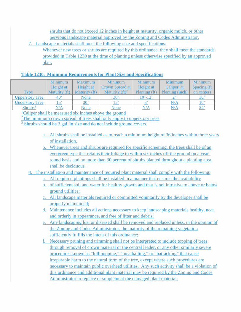
shrubs that do not exceed 12 inches in height at maturity, organic mulch, or other pervious landscape material approved by the Zoning and Codes Administrator.
7. Landscape materials shall meet the following size and specifications: Whenever new trees or shrubs are required by this ordinance, they shall meet the standards provided in Table 1230 at the time of planting unless otherwise specified by an approved plan;
Table 1230. Minimum Requirements for Plant Size and Specifications
Type
Minimum Height at
Maturity (ft)
Maximum Height at
Maturity (ft)
Minimum Crown Spread at
Maturity (ft)2
Minimum Height at
Planting (ft)
Minimum Caliper1 at
Planting (inch)
Minimum Spacing (ft on center)
Upperstory Tree 40’ None 30’ 10’-12’ 2” 30’ Understory Tree 15’ 30’ 15’ 8’ N/A 10’
Shrubs3 N/A None None N/A N/A 24’ 1Caliper shall be measured six inches above the ground 2The minimum crown spread of trees shall only apply to upperstory trees 3 Shrubs should be 3 gal. in size and do not include ground covers.
a. All shrubs shall be installed as to reach a minimum height of 36 inches within three years of installation.
b. Whenever trees and shrubs are required for specific screening, the trees shall be of an evergreen type that retains their foliage to within six inches off the ground on a year-round basis and no more than 30 percent of shrubs planted throughout a planting area shall be deciduous.
8. The installation and maintenance of required plant material shall comply with the following: a. All required plantings shall be installed in a manner that ensures the availability b. of sufficient soil and water for healthy growth and that is not intrusive to above or below
ground utilities; c. All landscape materials required or committed voluntarily by the developer shall be
properly maintained; d. Maintenance includes all actions necessary to keep landscaping materials healthy, neat
and orderly in appearance, and free of litter and debris; e. Any landscaping lost or diseased shall be removed and replaced unless, in the opinion of
the Zoning and Codes Administrator, the maturity of the remaining vegetation sufficiently fulfills the intent of this ordinance;
f. Necessary pruning and trimming shall not be interpreted to include topping of trees through removal of crown material or the central leader, or any other similarly severe procedures known as “lollipopping,” “meatballing,” or “hatracking” that cause irreparable harm to the natural form of the tree, except where such procedures are necessary to maintain public overhead utilities. Any such activity shall be a violation of this ordinance and additional plant material may be required by the Zoning and Codes Administrator to replace or supplement the damaged plant material;
g. All landscaping and screening shall be installed, inspected, and approved prior to the issuance of a certificate of occupancy;
h. If seasonal and/or prevailing weather conditions prohibit planting, the Zoning and Codes Administrator may authorize a temporary certificate of occupancy;
i. The owner of the property where landscaping is required shall be responsible for the maintenance and protection of all plant and screening material;
j. Failure to maintain or replace dead, damaged or diseased plant material or to repair a broken wall within 30 days of notification shall constitute a violation of this section;
k. If a catastrophic event occurs which destroys a large quantity of vegetation, the owner or lessee shall have 180 days to replant with extensions authorized by the Zoning and Codes Administrator; and
l. Replaced plant material must be in compliance with the minimum size, spacing, and quantity standards of this section.
9. Vehicular use area shall be designed to comply with the following: a. At least 10 percent of the total interior square footage of all vehicular use areas as
designed and constructed shall be dedicated to landscaping and shall meet the following requirements:
1. All areas of the parking lot framed by the required buffer and adjacent buildings (where the perimeter buffer is not required) shall be used in calculating the required interior landscaped area and the required interior landscaping shall be located within this area;
2. Each required interior landscaped area shall be at least 64 feet in size with no dimension less than four feet; and
3. A pass-through for pedestrian access shall be placed at intervals not less than one every 100 feet across landscape strips between parking aisles. No reduction in required vegetation will be permitted to accommodate this access. All such pedestrian access areas shall be clearly shown and labeled on the landscape plan;
b. Any vehicular use area shall require a minimum landscape buffer of eight feet in depth or a berm along the lineal boundary of all streets or alleys and five feet along all other perimeters of the vehicular use area, except that the perimeter buffer shall not be required where it interferes with pedestrian access to a building for which the parking is provided or with loading, unloading and utility areas;
c. Berms may be used to fulfill the requirements of the eight foot exterior landscape buffer along the linear boundary of streets or alleys and shall comply with the following:
1. Maximum rise to run ratio of 2:1 is provided; 2. Minimum depth of the berm shall be eight feet; and 3. All areas shall be stabilized and maintained with appropriate landscape
materials with ground covers, mulches or similar natural materials;
d. Within AR districts a decorative wall no higher than six feet may be used in lieu of a landscape buffer at the side or rear property lines with the approval of the Board of Architectural Review; and
e. If perimeter buffer requirements overlap with the bufferyard and screening requirements from Table 19-907, the greater requirement shall apply.
10. Landscaping requirements associated with vehicular use areas shall comply with the following: a. There shall be sufficient upper story trees within and around the vehicular use area to
ensure any portion of the vehicular use area is within 40 feet of a planted or retained tree trunk;
b. The trees shall be located within the front or side street setbacks; c. The minimum landscape area for each tree shall be no less than 170 square feet with four
feet minimum distance between all trees and paving at time of planting, measured at the base of the tree;
d. Shrubs within a landscape buffer abutting a street right-of-way or within a perimeter of the vehicle use area shall be arranged to form a continuous row, designed to be planted three feet on center and must occupy the buffer for which they were calculated;
e. The shrubs shall be planted no farther than four feet from the vehicular use area; f. Shrubs must be located within the interior landscaped area for which they were
calculated; and g. The required shrubs shall be maintained at a height of approximately 36 inches.
11. Other requirements include: a. All landscaped areas shall be stabilized and maintained with ground covers, mulches, or
similar natural materials to control weeds, prevent soil erosion and allow rainwater infiltration. Ground cover shall cover all portions of landscape area not occupied by landscape materials. Ground cover may consist of the following: grass or turf material, shrubs that do not exceed 12 inches in height at maturity, organic mulch, or other pervious landscape amenity approved by the Zoning and Codes Administrator;
b. All landscaped areas shall be protected from vehicle damage by the installation of curbing, wheel stops, or other comparable methods allowing for a 30 inch vehicle overhang; and
c. This standard shall not prohibit the use of planting areas as on-site storm water management devices. Vehicle overhang areas shall not count towards required minimum landscaping areas.
12. The following additional plantings required for residential development: a. In addition to other landscaping requirements, one upperstory tree shall be required to be
planted within the required open space for every three dwelling units in multi-family residential developments.
13. All bulk waste receptacles are subject to the following:
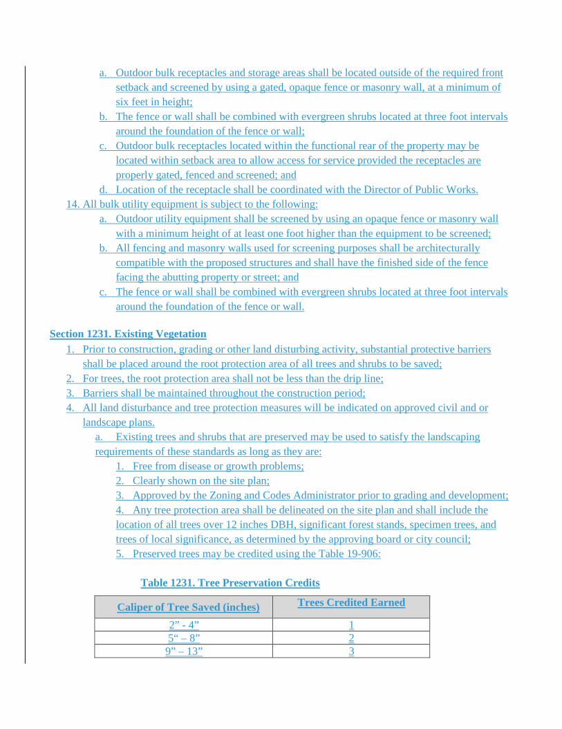
a. Outdoor bulk receptacles and storage areas shall be located outside of the required front setback and screened by using a gated, opaque fence or masonry wall, at a minimum of six feet in height;
b. The fence or wall shall be combined with evergreen shrubs located at three foot intervals around the foundation of the fence or wall;
c. Outdoor bulk receptacles located within the functional rear of the property may be located within setback area to allow access for service provided the receptacles are properly gated, fenced and screened; and
d. Location of the receptacle shall be coordinated with the Director of Public Works. 14. All bulk utility equipment is subject to the following:
a. Outdoor utility equipment shall be screened by using an opaque fence or masonry wall with a minimum height of at least one foot higher than the equipment to be screened;
b. All fencing and masonry walls used for screening purposes shall be architecturally compatible with the proposed structures and shall have the finished side of the fence facing the abutting property or street; and
c. The fence or wall shall be combined with evergreen shrubs located at three foot intervals around the foundation of the fence or wall.
Section 1231. Existing Vegetation
1. Prior to construction, grading or other land disturbing activity, substantial protective barriers shall be placed around the root protection area of all trees and shrubs to be saved;
2. For trees, the root protection area shall not be less than the drip line; 3. Barriers shall be maintained throughout the construction period; 4. All land disturbance and tree protection measures will be indicated on approved civil and or
landscape plans. a. Existing trees and shrubs that are preserved may be used to satisfy the landscaping requirements of these standards as long as they are:
1. Free from disease or growth problems; 2. Clearly shown on the site plan; 3. Approved by the Zoning and Codes Administrator prior to grading and development; 4. Any tree protection area shall be delineated on the site plan and shall include the location of all trees over 12 inches DBH, significant forest stands, specimen trees, and trees of local significance, as determined by the approving board or city council; 5. Preserved trees may be credited using the Table 19-906:
Table 1231. Tree Preservation Credits
Caliper of Tree Saved (inches) Trees Credited Earned
2” - 4” 1 5“ – 8” 2
9” – 13” 3
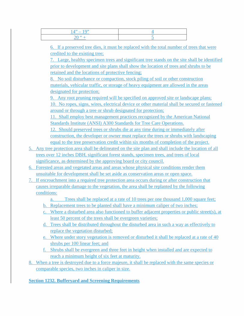
14” – 19” 4 20 “ + 5
6. If a preserved tree dies, it must be replaced with the total number of trees that were credited to the existing tree; 7. Large, healthy specimen trees and significant tree stands on the site shall be identified prior to development and site plans shall show the location of trees and shrubs to be retained and the locations of protective fencing; 8. No soil disturbance or compaction, stock piling of soil or other construction materials, vehicular traffic, or storage of heavy equipment are allowed in the areas designated for protection; 9. Any root pruning required will be specified on approved site or landscape plans; 10. No ropes, signs, wires, electrical device or other material shall be secured or fastened around or through a tree or shrub designated for protection; 11. Shall employ best management practices recognized by the American National Standards Institute (ANSI) A300 Standards for Tree Care Operations. 12. Should preserved trees or shrubs die at any time during or immediately after construction, the developer or owner must replace the trees or shrubs with landscaping equal to the tree preservation credit within six months of completion of the project.
5. Any tree protection area shall be delineated on the site plan and shall include the location of all trees over 12 inches DBH, significant forest stands, specimen trees, and trees of local significance, as determined by the approving board or city council.
6. Forested areas and vegetated areas and areas whose physical site conditions render them unsuitable for development shall be set aside as conservation areas or open space.
7. If encroachment into a required tree protection area occurs during or after construction that causes irreparable damage to the vegetation, the area shall be replanted by the following conditions:
a. Trees shall be replaced at a rate of 10 trees per one thousand 1,000 square feet; b. Replacement trees to be planted shall have a minimum caliper of two inches; c. Where a disturbed area also functioned to buffer adjacent properties or public street(s), at
least 50 percent of the trees shall be evergreen varieties; d. Trees shall be distributed throughout the disturbed area in such a way as effectively to
replace the vegetation disturbed; e. Where under story vegetation is removed or disturbed it shall be replaced at a rate of 40
shrubs per 100 linear feet; and f. Shrubs shall be evergreen and three feet in height when installed and are expected to
reach a minimum height of six feet at maturity. 8. When a tree is destroyed due to a force majeure, it shall be replaced with the same species or
comparable species, two inches in caliper in size. Section 1232. Bufferyard and Screening Requirements
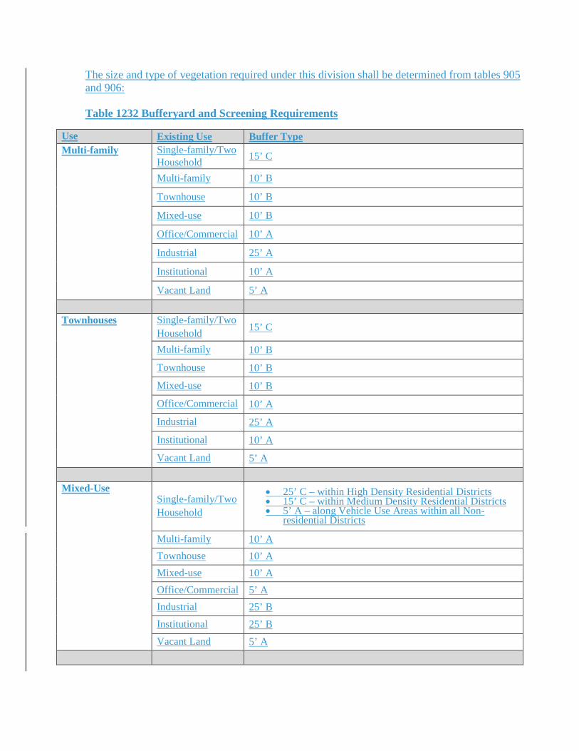
The size and type of vegetation required under this division shall be determined from tables 905 and 906: Table 1232 Bufferyard and Screening Requirements
Use Existing Use Buffer Type Multi-family Single-family/Two
Household 15’ C
Multi-family 10’ B
Townhouse 10’ B
Mixed-use 10’ B
Office/Commercial 10’ A
Industrial 25’ A
Institutional 10’ A
Vacant Land 5’ A Townhouses Single-family/Two
Household 15’ C
Multi-family 10’ B
Townhouse 10’ B
Mixed-use 10’ B
Office/Commercial 10’ A
Industrial 25’ A
Institutional 10’ A
Vacant Land 5’ A Mixed-Use
Single-family/Two Household
• 25’ C – within High Density Residential Districts • 15’ C – within Medium Density Residential Districts • 5’ A – along Vehicle Use Areas within all Non-
residential Districts
Multi-family 10’ A Townhouse 10’ A Mixed-use 10’ A Office/Commercial 5’ A Industrial 25’ B Institutional 25’ B Vacant Land 5’ A
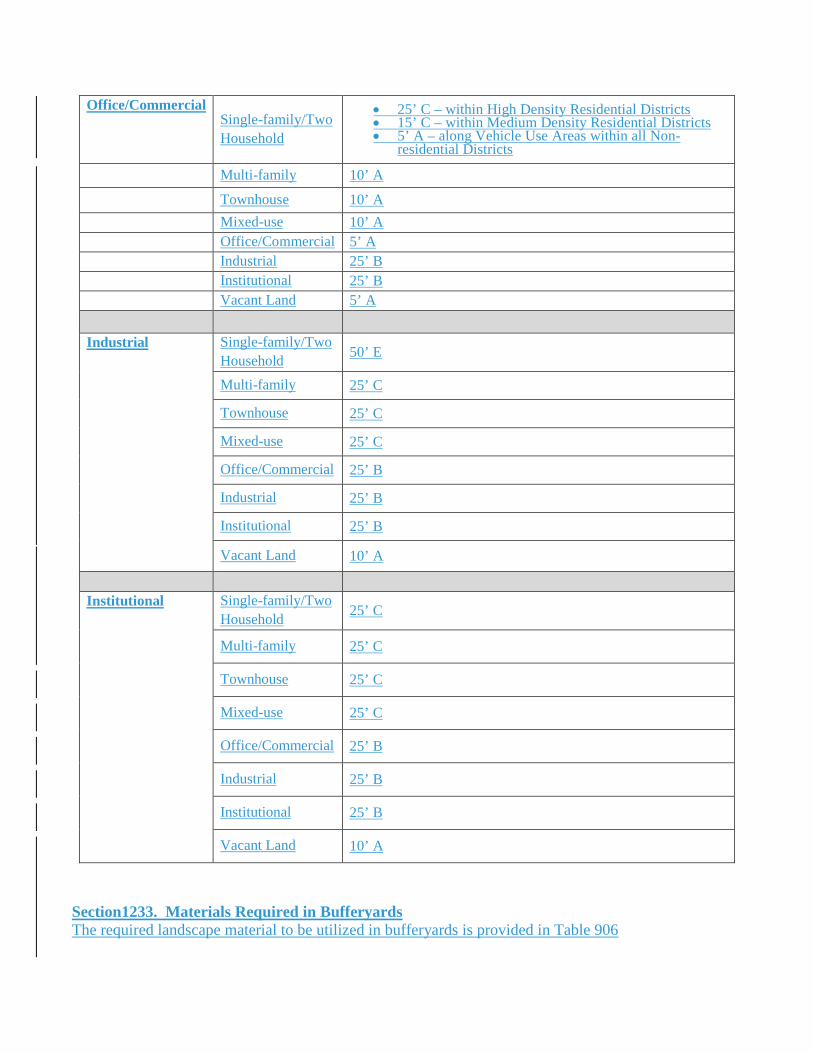
Office/Commercial Single-family/Two Household
• 25’ C – within High Density Residential Districts • 15’ C – within Medium Density Residential Districts • 5’ A – along Vehicle Use Areas within all Non-
residential Districts
Multi-family 10’ A
Townhouse 10’ A Mixed-use 10’ A Office/Commercial 5’ A Industrial 25’ B Institutional 25’ B Vacant Land 5’ A Industrial Single-family/Two
Household 50’ E
Multi-family 25’ C
Townhouse 25’ C
Mixed-use 25’ C
Office/Commercial 25’ B
Industrial 25’ B
Institutional 25’ B
Vacant Land 10’ A
Institutional Single-family/Two
Household 25’ C
Multi-family 25’ C
Townhouse 25’ C
Mixed-use 25’ C
Office/Commercial 25’ B
Industrial 25’ B
Institutional 25’ B
Vacant Land 10’ A
Section1233. Materials Required in Bufferyards The required landscape material to be utilized in bufferyards is provided in Table 906
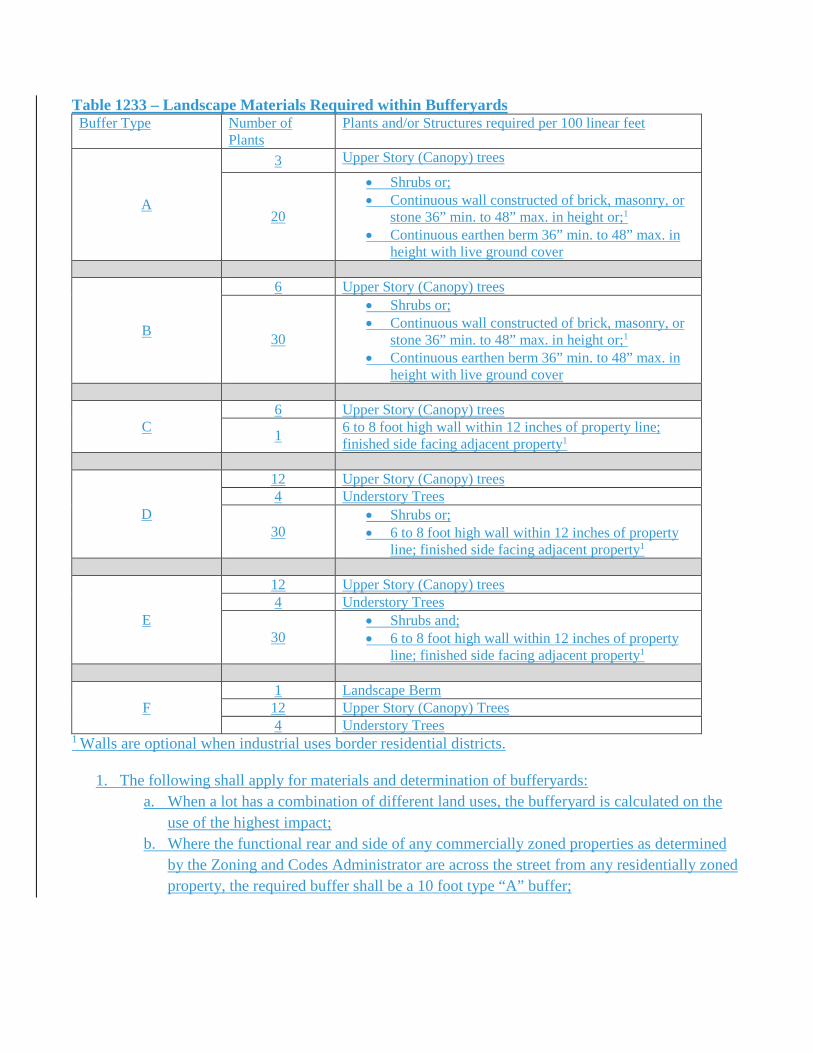
Table 1233 – Landscape Materials Required within Bufferyards Buffer Type Number of
Plants Plants and/or Structures required per 100 linear feet
A
3 Upper Story (Canopy) trees
20
• Shrubs or; • Continuous wall constructed of brick, masonry, or
stone 36” min. to 48” max. in height or;1 • Continuous earthen berm 36” min. to 48” max. in
height with live ground cover
B
6 Upper Story (Canopy) trees
30
• Shrubs or; • Continuous wall constructed of brick, masonry, or
stone 36” min. to 48” max. in height or;1 • Continuous earthen berm 36” min. to 48” max. in
height with live ground cover
C 6 Upper Story (Canopy) trees
1 6 to 8 foot high wall within 12 inches of property line; finished side facing adjacent property1
D
12 Upper Story (Canopy) trees 4 Understory Trees
30 • Shrubs or; • 6 to 8 foot high wall within 12 inches of property
line; finished side facing adjacent property1
E
12 Upper Story (Canopy) trees 4 Understory Trees
30 • Shrubs and; • 6 to 8 foot high wall within 12 inches of property
line; finished side facing adjacent property1
F 1 Landscape Berm 12 Upper Story (Canopy) Trees 4 Understory Trees
1 Walls are optional when industrial uses border residential districts.
1. The following shall apply for materials and determination of bufferyards: a. When a lot has a combination of different land uses, the bufferyard is calculated on the
use of the highest impact; b. Where the functional rear and side of any commercially zoned properties as determined
by the Zoning and Codes Administrator are across the street from any residentially zoned property, the required buffer shall be a 10 foot type “A” buffer;
c. Where industrial and institutional uses are across the street from any residentially zoned properties, the property shall be buffered as if the properties were abutting without the fence or wall;
d. Where the adjacent land use is nonconforming, the depth of the buffer and live landscape materials shall be reduced by 60 percent;
e. When two landscape buffers are abutting the materials for either buffer may be intermingled provided the required amount for each buffer is maintained. A maintenance agreement between the property owners for the landscape areas will be required to be approved by the Zoning and Codes Administrator before the buffer is accepted.
f. When perimeter landscape buffers overlap, the greater requirement shall apply. 2. Exceptions to Landscape Materials Requirements:
a. When the site is impacted by one or more of the following the materials within a required landscape buffer may be modified as follows:
i. When natural body of water or stream that is within the required landscape buffer the amount of trees and shrubs will be reduced by the linear area affected; ii. When the adjacent property is on elevation greater than six feet above from the developed property the requirement for any wall will be removed by the linear feet affected provided the property line is within six feet of the base of the slope;
b. When a parcel of land is partially developed then the area that is not developed is not required to be buffered provided:
i. The undeveloped area is at least 0.50 acres; ii. The closest improvement, buildings, parking areas, or any other structure is 100 feet from the neighboring property; iii. There is no grading, clearing or any other disturbance of the area, other than water/sewer installation; iv. Any development or site disturbance within this area will require installation of the required buffer, if any portion of this property has been graded or clear cut of vegetation within the past three years.
c. For “E” type bufferyards, a wall is not required when there are no structure or vehicle use areas within four times the width of the required buffer.
Section 1234. - Acceptable plant materials In those instances where the natural vegetation and topography are insufficient to achieve the desired level of screening required by this appendix, a planted buffer shall be provided and shall consist of plant material of such growth characteristics as will provide an acoustical and visual screen and/or erosion control barrier. Planted materials shall conform to the following specifications: Trees used for screening purposes should be native to the region and shall not be deciduous. Trees should be at least three feet in height above the ground when planted or which will, in normal growth, attain a height of six feet within three years. Shrubs that are used to form hedges shall not be deciduous. Shrubs shall be a least two feet above the ground level when planted. They should be spaced in such a way that, when mature, they will form a continuous visual screen (hedge) that is at least six feet in height.
For purposes of erosion control, ground covers, perennial plants and shrubs shall be placed to facilitate development of a continuous root network within one year or the period of construction whichever is the greater. Section 1235. - Maintenance of buffers and landscape strips. The owner and/or user of the property shall be responsible for installing the trees, shrubs and ground covers and maintaining them in good health in a neat and orderly appearance. This includes irrigating or watering, fertilizing, pruning and replanting where necessary. In cases of non-compliance, the administrative officer shall be empowered to take action as provided by law to ensure maintenance of all plant and landscaping materials. Section 1236. - Administration and enforcement. Where buffers are required, the applicant must demonstrate, whether on appropriate plans or after inspection by the administrative officer, that the plant materials in place or installed achieve the required screening and/or erosion controls. All site plans, plot plans and grading and drainage plans shall indicate all required buffers and landscape strips. Required buffers, landscape strips, and parking lot landscaping shall be installed in accordance with approved plans prior to the issuance of a certificate of occupancy. Certificates of occupancy may be withheld if, after inspection, the required buffers and landscape strips have not been installed in accordance with approved plans. However, owing to special conditions or exceptional circumstance such as drought, said buffers and landscape strips may be installed within 90 days after the issuance of a certificate of occupancy, provided that a letter of credit, escrow money, performance bond or other approved alternative is submitted to the administrative officer prior to the issuance of a certificate of occupancy. Section 1237. - Exception to buffer, landscape, screening and open space requirements The single exception to the buffer, landscape, screening and open space requirements is public and semi-public buildings and uses to house communication equipment, pumps, security or similar such uses, as determined by the administrative officer, located on small parcels that could not normally meet the buffer, landscape, screening and open space requirements in section1228,1229, 1230, 1231, 1232, and 1233.