gunpowder creek watershed health report - phase ii
TRANSCRIPT

The Gunpowder Creek Watershed Initiative
(GCWI) is developing a watershed plan for
Gunpowder Creek and its tributary creeks.
As a part of this process, samples are being
collected to determine the health of these
creeks and watersheds. In order to share the
findings from these samples with residents
and stakeholders of Boone County, GCWI has
borrowed a “report card” approach from the
Kentucky Division of Water’s (KDOW) Total
Maximum Daily
Load Section.
With assistance
from KDOW, this
approach
processes the
findings from the
samples collected.
A letter grade is
calculated for
different factors
that influence the
watersheds and
affect the quality
of the water in the
creeks flowing in
these watersheds.
After grades have
been calculated
for the individual
factors, these
grades are
combined and
averaged to
develop an overall
grade for
Gunpowder Creek Watershed.
A watershed is an area of land where runoff
flows to a common stream. When creeks
come together, the two creeks’ watersheds
combine to make a larger watershed. Many
small creeks, such as Fowlers Fork and
Riddles Run, flow into Gunpowder Creek.
Eventually, Gunpowder Creek flows into the
Ohio River, and is therefore part of the Ohio
River Watershed. A map of the watershed is
included in this report card. As rainfall or
water from melting snow and ice flows across
the land and structures in the watershed, it
picks up any pollution on the ground and
carries it into creeks. This includes bacteria
from humans and animals, fertilizers from
homes, farms, and businesses, oils and
chemicals from roads, parking lots, homes
and farms, dirt from construction areas and
farms, and heat from rooftops, roads, parking
lots and other paved areas.
When areas of land are covered over with
buildings, pavement, and other structures, we
prevent the rain and snow melt from soaking
into the ground, disrupting this natural cycle.
This sends more water to creeks more quickly
and causes more
frequent and severe
flooding. The
increased frequency
and strength of
flooding in creeks
cause erosion that
adds smothering dirt
to the system and
cause stream banks to
become unstable.
In 2011 and 2012
project staff and
students from the
Thomas More College
Environmental
Academy were trained
and then conducted
tests to gather
scientific information.
Based on this
information, GCWI has
calculated a 2012
“report card grade” of
C for the Gunpowder
Creek Watershed. This
is higher than the C– that it received in 2011.
Although the overall grade went up, some
grades went down (dissolved oxygen and
specific conductivity), some stayed the same
(riparian zone and total habitat) and
improvement was seen in certain indicators
(macroinvertebrates and E. coli). This health
report discusses some of the changes that
were seen between 2011 and 2012. These
two years were extreme in regard to rainfall,
with 2011 being very wet and 2012 being
very dry. These comparisons can help
understand the potential sources of
pollutants, ways to reduce them, and help
those who live in the watershed understand
how their actions affect the water in their
streams.
Gunpowder Creek
Watershed Initiative
Mark Jacobs Boone County
Conservation District 6028 Camp Ernst Rd Burlington, KY 41005
859-586-7903 www.boonecountyky.org/bccd/
For more information
Like “Kentucky Watershed Health Reports” on Facebook and check DOW webpage for watershed Health Reports at
http://water.ky.gov/waterquality/Pages/ TMDLHealthReports.aspx
Water Quality Reports
http://water.ky.gov/waterquality/Pages/default.aspx
Or contact:
Kentucky Division of Water
Lajuanda Haight-Maybriar Licking River Basin Coordinator 200 Fair Oaks Lane 4th Floor Frankfort, KY 40601 502-564-3410 Ext. 4937 What other watersheds are doing:
• Hinkston Creek at http://
www.hinkstoncreek.org/index.html
• Strodes Creek Conservancy at
http://www.strodescreek.org
• Friends of Stoner Creek at
http://www.stonercreek.us/
This work was funded in part by a
grant from the U.S. Environmental
Protection Agency under §319(h) of the Clean Water Act through the
Kentucky Division of Water to the
Boone County Conservation District
(Grant # 09-10).
The Energy and Environment Cabinet
and Conservation Districts prohibit
discrimination in all programs and
activities on the basis of race, color, national origin, sex, religion, age,
disability, political beliefs, sexual
orientation, or marital or family
status.
Gunpowder Creek Watershed
Health Report - Phase II Gunpowder Watershed Initiative Steering Committee
Thursday, March 21, 2013

1. Information collected was divided into indicators of water quality or indicators of biological health.
2. Each indicator received a grade, A through F, according to the results of our study, which were compared to health and science requirements and KDOW scientific information.
3. The grades from each biological health
indicator were averaged to achieve a biological health score.
4. Similarly, each indicator of water quality was averaged to achieve a water quality score.
5. These two scores were averaged to achieve a watershed health grade.
Indicators of
Water Quality
Indicators of
Biological Health
Watershed Health
Watershed
Grade: C
Worst in Show: For the second year
in a row, Long Branch sub-watershed
received the lowest grade with a D+.
Although other sites experienced
improvement in their E. coli levels, this site
still had such high E. coli levels that it scored
an F. Poor habitat, macroinvertebrate
communities and water quality kept this site
from reaching the C level.
Best in Show: For the second year
in a row, Gunpowder Creek’s
mainstem sub-watershed had the
highest overall grade scoring a B. Improved
macroinvertebrate communities and lower
levels of E. coli brought this site up from a
C+ that it received last year. However,
elevated levels of TSS and nutrients kept this
site from scoring in the A range.
How was Gunpowder Creek Graded?
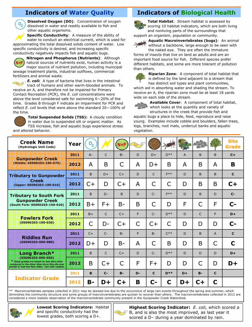
Dissolved Oxygen (DO): Concentration of oxygen
dissolved in water and readily available to fish and
other aquatic organisms.
Specific Conductivity: A measure of the ability of
water to conduct an electrical current, which is used for
approximating the total dissolved solids content of water. Low
specific conductivity is desired, and increasing specific
conductivity negatively impacts fish and aquatic bugs.
Nitrogen and Phosphorus (Nutrients): Although
natural sources of nutrients exist, human activity is a
major source of nutrient pollution, including municipal
sewage treatment plants, industrial outflows, commercial
fertilizers and animal waste.
E. coli: A type of bacteria that lives in the intestinal
tract of humans and other warm-blooded animals. To
receive an A, and therefore not be impaired for Primary
Contact Recreation (PCR), the E. coli concentrations were
above the level considered safe for swimming 0—20% of the
time. Grades B through F indicate an impairment for PCR and
reflect E. coli levels that were above the standard 20—100% of
the time.
Total Suspended Solids (TSS): A cloudy condition
in water due to suspended silt or organic matter. As
TSS increase, fish and aquatic bugs experience stress
and altered behavior.
Indicators of Water Quality
Total Habitat: Stream habitat is assessed by
scoring 10 habitat indicators, which are both living
and nonliving parts of the surroundings that
support an organism, population or community.
Aquatic Macroinvertebrates (bugs): An animal
without a backbone, large enough to be seen with
the naked eye. They are often the immature
forms of insects that live on land as adults and are an
important food source for fish. Different species prefer
different habitats, and some are more tolerant of pollution
than others.
Riparian Zone: A component of total habitat that
is defined by the land adjacent to a stream that
has distinct soil types and plant communities,
which aid in absorbing water and shading the stream. To
receive an A, the riparian zone must be at least 18 yards
wide on each side of the stream.
Available Cover: A component of total habitat,
which looks at the quantity and variety of
structures in the creek that provide fish and
aquatic bugs a place to hide, feed, reproduce and raise
young. Examples include cobble and boulders, fallen trees,
logs, branches, root mats, undercut banks and aquatic
vegetation.
Indicators of Biological Health
Creek Name (Hydrologic Unit Code)
Year Site
Grade
Gunpowder Creek (Middle: 05090203-190-070)
2011 A- C B- D D+ D** A B B C+
2012 A B C A D+ B A B A B
Tributary to Gunpowder
Creek (Upper: 05090203-190-010)
2011 B D+ C+ D C F** D B B C
2012 C+ D C+ A C C D B B C+
Tributary to South Fork
Gunpowder Creek (South Fork: 05090203-190-020)
2011 B D- B D C- F** D B D C-
2012 B+ F+ B- B C D F C F C-
Fowlers Fork (05090203-190-030)
2011 B+ C C+ F C- D** D C F D+
2012 C D- C+ C C+ C D D D C-
Riddles Run (05090203-090-080)
2011 C+ C- B- F B- C** D B A C
2012 D+ D B- A C B D B C C
Long Branch* (05090203-090-050)
* these grades are based on less data when
compared to the other sites since this site was pooled or had low flow often. Use with caution.
2011 B C C+ D C- D** D D D D+
2012 B C+ C F F+ D D C D D+
Indicator Grade 2011 B C- B- D- C D** D+ B- C
2012 B- D+ C+ B C- C D+ C+ C
** Macroinvertebrate samples collected in 2011 may be skewed low due to the occurrence of large rain events throughout the spring and summer, which
diminishes the community structure and some groups of macroinvertebrates are quicker to recover than others. The macroinvertebrates collected in 2012 are
considered a more realistic observation of the macroinvertebrate community present in the Gunpowder Creek Watershed.
Lowest Scoring Indicators: Habitat
and specific conductivity had the
lowest grades, both scoring a D+.
Highest Scoring Indicator: E. coli, which scored a
B, and is also the most improved, as last year it
scored a D– during a year dominated by rain.

• Protect the good that remains. Work with local government
and land owners to protect areas that are less degraded and improve land management to minimize further degradation.
• Trees and other plants protect and restore water qual-
ity and biological health.
◊ Leave in place or establish trees and other vegetation
along streams to provide natural filters that stabilize stream banks, minimize erosion, regulate water flow, provide shade, retain sediment, absorb excess nutri-ents, and provide habitat.
◊ Don’t mow to the edge of a stream. Leave a buffer of
trees and other vegetation at least 18 yards wide along the stream bank.
◊ Allow fallen trees, logs, leaves, gravel, cobble and
boulders to remain in the stream to create habitat for fish and macroinvertebrates to feed, find refuge and reproduce.
◊ Minimize streamside grazing by animals.
• Reduce Total Suspended Solids (TSS)
◊ Maintain streamside vegetation.
◊ Plant cover crops.
◊ Install settling ponds.
◊ Reduce animal access to streamside grazing.
◊ Guard waterways during construction activities.
• Education
◊ Check out some of the resources provided on the front
page. Knowing how our daily actions affect water quality is half the battle to improve it.
• To keep water safe for swimming
◊ Maintain functional septic systems and replace failing
septic systems.
◊ Pick up after your pets. Dispose of animal waste prop-
erly.
◊ Keep animals out of the stream.
• Other Tips
◊ Keep grass clippings and petroleum products out of
storm drains. This material enters the stream directly without treatment.
◊ Dispose of trash and recyclables properly.
◊ Disconnect downspouts from storm sewers.
◊ Install a rain garden to absorb storm water and reduce
the amount of runoff from your property.
◊ Consider using porous pavement for driveways and
parking lots.
◊ Have your soil tested and apply fertilizers according to
the results of the soil test. Apply pesticides according to label directions. Check the weather before applying fertilizers and pesticides to be sure they will be ab-sorbed before it rains!
• Volunteer
◊ Become a certified citizen water quality monitor by
joining Kentucky Watershed Watch. Contact Water-shed Watch in Kentucky at water.ky.gov/wsw/Pages/default.aspx or contact Jo Ann Palmer at 800-928-0045 or [email protected]
◊ Organize a creek clean-up to remove litter along and
within Gunpowder Creek.
POSITIVES
By comparing the results of samples collected from a stream in a wet year (2011) to the results of the same set of samples collected in a dry year (2012), one can learn a lot about the watershed and the potential sources of pollution. Some indicators, such as habitat and riparian zone, are not affected by rainfall and change more slowly over time. So, it is not surprising that these scores were similar between the two years.
Water quality indicators, on the other hand, can change dramatically from year to year, especially when the amounts of rainfall are different. In 2011, when the weather was wet, the E. coli levels were high, but then in 2012, which was dry, most of the E. coli levels were low. This demonstrates that the source of E. coli in the Gunpowder Creek watershed is most often linked to runoff events when rain washes the bacteria present on the land into the streams.
Conversely, specific conductivity and nutrient levels were low in 2011 when the weather was wet, but were higher when the weather was dry in 2012. This demonstrates that the source of dissolved solids (measured by specific conductance) and nutrients is most often linked to sources that release water regardless of weather, but become diluted by rainfall. Additionally, dissolved oxygen (DO) was lower in 2012 when compared to 2011, which is not surprising since warm, stagnant water holds less oxygen than cold, moving water, and this can again be explained by the differences in rainfall between the two years.
Macroinvertebrate communities are sensitive to both habitat and water quality issues, which makes them such an important group of animals in the watershed. Their types and numbers can change from year to year in response to changes created by higher and lower amounts of rainfall. The macroinvertebrates scored a C in 2012, which was better than in 2011 when
they scored a D. However, the 2011 macroinvertebrate samples were collected soon after a large rain event, and this may have affected their community makeup. Some types of macroinvertebrates recover more quickly than others, so some types may have been incorrectly represented. In 2012, the macroinvertebrate samples were collected in lower flow conditions and without a recent large rain event. This resulted in an improved score, but the continuing habitat and water quality issues prevented the
macroinvertebrate community from achieving a better than average score. So, the score of C may or may not be representative of a true improvement in macroinvertebrates.
What can you do?
GRAY AREA NEGATIVES
Summary: The middle ground dominates during a year of drought