gulf coast incident management team · pdf filegulf coast incident management team ... the...
TRANSCRIPT

GULF COAST INCIDENT MANAGEMENT TEAM
ORPHAN ANCHOR PHASE II PROGRAM
Report to the Federal On-scene Commander
SUBMITTED 06-20-11
Received by: Federal On-scene Commander: _________________________ Date: ____________ BP Incident Commander: _________________________ Date: ____________
Gulf Coast Incident Management Team
Orphaned Anchor Program Phase II

GC-IMT Orphan Anchor Program Phase II Report to the FOSC Page 2 of 57
Report to the Federal On-Scene Commander
The purpose of this report is to provide the Federal On-Scene Coordinator (FOSC) for the Deepwater Horizon (DWH) MC252 Spill of National Significance with the Orphaned Anchor Program Phase II Program description and results.
The report describes the scope of the project, the technology employed to locate any Danforth anchors which may remain in place after being used to secure shoreline protection boom, the design principals of Danforth anchors and how they were deployed, local sedimentation processes and the two Net Environmental Benefit Analyses (NEBAs) completed prior to the Phase II survey operations and prior to any recovery operations.
The Project team used the refined passive technology developed during the Phase I Pilot over a larger area in the waters of St. Bernard and Jefferson Parish. The findings of the bottom conditions and composition from the use of the passive system were verified by manual checks and measurements.
Executive Summary
• Fewer anchor targets were identified than anticipated. Those located were found in areas consistent with the original boom placement.
Key Findings
• Anchor targets were found buried at an average depth of 1.9 – 2.1 meters, where the risk of damage to personal and commercial vessels is extremely low.
• The anchor targets were generally located where the very soft, unconsolidated surface sediments met more consolidated and competent bottom conditions.
• Deep burial of Danforth anchors, in soft bottom conditions, is consistent with how the anchors are designed to perform.
• No free-floating polypropylene rope was identified over the course of the project. • To date, there have been no documented reports of vessel incidents with orphan anchors. • The degradation of the anchor material (steel and galvanized steel) poses no significant threat to
human health or the environment. • Because the anchor targets were found buried so deep, no attempts were made to recover them due
to personal safety and the NEBA associated with removal of the over-burden sediment. • Over the course of Phase I, it was evident that the technology utilized to locate the placed anchors was
extremely effective. That same technology, coupled with algorithms developed to make it more effective, was applied to Phase II in an effort to find the greatest number of anchors.
• The technology employed for detection of orphan anchors in the surveyed area was successful in locating orphan anchors (46) as well as a very large number (1157) of other ferrous objects, which the State of Louisiana should consider reviewing as they may pose a hazard to navigation and risk to commercial and personal vessels (the comprehensive search data should be provided to the State of Louisiana for review and for security of information).

GC-IMT Orphan Anchor Program Phase II Report to the FOSC Page 3 of 57
Table of Contents
Background and Introduction 4
Purpose and Scope of Orphan Anchor Phase II Project 4
Passive Search Technology Utilized 12
Danforth Anchor Overview 10
Sedimentation 12
Net Environmental Benefit Analysis (NEBA) 15
NEBA Prior to Survey Operations (March 18, 2011)
NEBA Prior to Recovery Operations (June 13, 2011)
Results 16
St. Bernard Parish Division 4
St. Bernard Parish Division 5
Jefferson Parish
Key Findings 26
Conclusions 26
Appendices
A – Pre-Phase II Survey Net Environmental Benefit Analysis (NEBA) 27 B – Pre-Phase II Recovery Net Environmental Benefit Analysis (NEBA) 38 C – GV-882TVG Cesuim Magnetometer and Transverse Gradiometer 49 D – KNUDSEN 3200 Sub-Bottom Profiler 51 E – Marine Sonic Side-Scan Sonar 52

GC-IMT Orphan Anchor Program Phase II Report to the FOSC Page 4 of 57
During the DWH Oil Spill Response in spring/summer 2010, numerous Vessels of Opportunity (VoOs) were employed by the response to place oil spill containment boom in near shore areas to prevent oiling of shorelines. Typically a length of boom was anchored at one end then deployed over the transom with additional anchors deployed along the boom length to secure it in place. Containment boom was deployed for an extended period of months in most cases. Boom was supplied from numerous sources and thus a wide variety of sizes, shapes, colors and lengths were deployed. This program resulted in approximately 3.8 million linear feet of containment boom placed along the shoreline of the Gulf of Mexico of which approximately 2.0 million linear feet were deployed in Louisiana waters. Due to the urgency and pace used to deploy the containment boom, the exact number and location of the anchors was not recorded and is not available. Due to the extended period of use as well as the mooring load placed on the anchor system during normal and high wind and wave periods it was common practice to perform normal boom maintenance and redeploy the boom into its intended position. There are limited records of this boom maintenance activity in the response.
Once free oil from the DWH spill was no longer on the water surface and no longer posed a threat for oiling shorelines, a program to collect the boom and anchors was implemented. VoOs were dispatched to collect the boom and anchors. Although most boom anchors were collected at that time, some of the VoO operators, likely due to the size and capability of their vessels, were unable to recover all of them. Because of natural forces on the mooring system while the boom was deployed as well as the inability to recover all the anchors upon retrieval, it is a reasonable assumption that a small percentage remain in their deployed position and have been subsequently ‘orphaned’.
Background and Introduction
At the direction of the FOSC, the Project Team utilized the best available technology to locate and evaluate the feasibility of recovering the orphaned anchors. Additionally, the original NEBA recommended a limited reconnaissance in key areas of higher risk such as lanes of high boat traffic where records and local knowledge gave guidance on locations where booms with anchors had been deployed. The reconnaissance was intended to provide data on what representative portion of anchors were left in place and whether the anchors left behind were buried in sediment or at the sea bottom. Further the reconnaissance would also provide data on whether or not associated polypropylene rope had sunk to the sea floor or was floating near surface as a potential hazard. Following the completion of the Phase I Pilot Orphan Anchor Project which developed and verified the technology to locate orphaned anchors, the field work for the second phase of the Orphan Anchor program began April 6, 2011 and ended on May 23, 2011. The project was intended to mitigate potential propulsion entanglement threats from suspended polypropylene anchor rope and possible collision hazards with embedded orphaned anchors (a particular concern to commercial and recreational mariners) in heavily trafficked waterways. Additionally, with consideration for safety, the Project team needed to determine whether there would be a net environmental benefit from removal of any remaining orphaned anchors. At the conclusion of this phase of the program, the Project team was to present the findings to the FOSC to help inform decisions regarding further actions.
Purpose and Scope of Orphan Anchor Phase II Project

GC-IMT Orphan Anchor Program Phase II Report to the FOSC Page 5 of 57 The 73507 anchors purchased during the response and the inventory of 71779 after boom recovery operations were completed indicate about 1728 or 2.35% of the purchased anchors were unaccounted for across the entire Gulf of Mexico. This number and percentage may be orphaned in place and/or may have been lost due to poor record keeping or pilferage. Detection of orphaned anchor and orphaned anchor related polypropylene rope in selected areas was completed through the use of multiple instruments including concurrent acoustic and magnetic surveys. Focus was centered on shallow water depth, key pre-determined high volume traffic locations that present the highest degree of hazards to navigation for both commercial and recreational traffic within the Inland Bays, Passes and Waterways of St. Bernard and Jefferson Parishes. During the acoustic and magnetic surveys (same method used for locating unexploded ordnance) for anchor detection, a Marine Sonic 600kHz side-scan sonar was employed to investigate magnetic anomalies that did not match known GIS data. Magnetic data was collected using the Geometrics G-882TVG system and one of the gradiometers surveyed at higher speeds (8-10 knots) and wider survey swaths from Research 2 (clearance vessel). All potential magnetic anomalies detected were investigated with the Marine Sonic 600 kHz transducer and second gradiometer at standard survey speeds (2.5 – 3.5kts) aboard Research 1 (discreet target hunting vessel). These oceanographic systems ran concurrently and allowed for greater mapping area at higher speeds with the customized gradiometer. All identified signatures matching the acoustic signal of possible orphaned anchors in the GIS data were mapped with Hemisphere VS101 GPS and readied for final review. Discreet target identification also included intensive area coverage with a Knutsen 3200 sub-bottom profiler. The side-scan was utilized to determine visibility of orphaned anchors and to investigate the presence of attached poly rope. During calibration at the beginning of Phase II, a 43 pound, Danforth anchor was placed on the sea floor and within hours sank to a depth of 2.8 meters below the mud line. The Project Coordinator working with local marine experts involved in the deployment, maintenance and recovery of boom in the survey area as well as GIS boom location data and topographical layouts, developed the search area criteria based on the best data available and a potential ‘confidence of anchor location matrix’. The aerial extent of each search grid was adjusted to account for varying confidence levels in where the boom and anchors were set and possibly reset during boom maintenance. This resulted in a wider search area where lower confidence of anchor location existed and a more limited search area where confidence was higher. The search locations selected are displayed in detail on the GIS maps contained in the Results section of this report. All areas where boom and anchors were used in St. Bernard Parish Division 4 and 5 were surveyed. At the request of the State of Louisiana, an additional limited and prioritized set of areas were surveyed in Jefferson Parish Division 1. The detection search collected concurrent digital and magnetic data using high-resolution Marine Sonic 600kHz Side Scan Sonar (SSS), Geometrics G-88TVG Gradiometer and a Knudsen 3200 scientific echo sounder in the search grids of Saint Bernard and Jefferson Parish. It was determined using test anchors that measurable signatures (between 5nt and 150nt) were evident at 50 to 100 ft of distance. These line spacing’s were determined during anchor calibration testing in Phase I and verified each morning and afternoon during Phase II (patch testing). Clearings, or high-speed passes (7-10 Knots), were made with the towed gradiometer on parallel lines at intervals of 100 feet. Utilizing this evidence, in addition to data review and discussion with Mikhail Tchernychev (software developer for the gradiometer), a search plan/grid was developed for each probable boom location. The plan included clearing passes spaced between 50 and 100 ft intervals to insure

GC-IMT Orphan Anchor Program Phase II Report to the FOSC Page 6 of 57 there was never more than 50 ft of distance between the vessel and potential signatures. All anomalies fitting the parameters between 5nt and 150nt were labeled for low speed narrow swath discreet target identification using higher resolution equipment. The post-processing GIS team further investigated the data signatures acquired in the field using dipole inversion software, which provided quality assurance around data interpretation to produce a more accurate listing of signatures requiring further identification. Using a gradiometer, discreet target identification included 25 ft passes with gradiometer in a perpendicular pass grid for the surrounding 100 ft radius centering on the target mark determined in the clearing pass. Field adjustments were made to the grids based on further analysis of anomalies during data collection. Data collected during the discreet target identification was presented to the offsite GIS post-processing team to determine specific geo-reference and signature profile for comparison with known constants derived from survey activity with test anchors in Phase I.
Typical clearing and discreet pass grids for West South Canal (St. Bernard Division 5) – the area search boundaries are marked in light yellow; the wide spaced lines are the high speed search (gradiometer only). The tightly spaced lines are the low speed investigations (uses gradiometer plus side scan plus sub-bottom profiling) – the red dots denote eliminated potential targets, the green dots are anchor signatures.
Anchor Signature GREEN Dot
Other Debris RED Dots
5.6 West South Canal Ferrous: 58 Anchor Signature: 2 Average Depth of Consolidation (m): 2 Potentially Recoverable: 0

GC-IMT Orphan Anchor Program Phase II Report to the FOSC Page 7 of 57
Acoustic and Magnetic Search Tools
Passive Search Technology Utilized
A magnetometer is an instrument used to measure the strength or direction of the magnetic field. Ferrous objects all create recordable signatures recognized by changes in the magnetic field near them. By recording the levels and reviewing the data stream it is possible to locate and estimate the size of a ferrous object. The Gradiometer’s dual magnetometer configuration consists of two magnetometers mounted on a rigid frame at a known distance, which allows for a more accurate location estimate of signatures through data interpolation from the individual signature amplitudes.
The G-882TVG cesium magnetometer and transverse gradiometer (see Appendix C for detailed specifications) was utilized due to its effectiveness shown in Phase-1 of the Orphaned Anchor Project. The G-882TVG’s framework is designed and configured to be towed in deep water and to “Fly” a short, controlled distance from the sea floor (5m or less). This posed an interesting challenge as to how to modify its design to override its inherent diving nature. Multiple tests were done with a variety of flotation configurations before the current design was reached that allows the gradiometer to be towed and collect data from the surface at speeds up to 8 knots. This allowed for areas to be cleared relatively quickly compared to the original configuration.
Gradiometer Side-scan sonar is an acoustic search device used in underwater imaging. It is most commonly used to image marine substrates. The side-scan transmits a very narrow vertical fan shaped beam of acoustic energy (sound) from two transducers - one on the port and one on the starboard side of a torpedo like device commonly referred to as a towfish. The acoustic energy travels through the water and reflects off of things such as the seafloor or items on the seafloor. The acoustic energy that is reflected or is absorbed by the seafloor and

GC-IMT Orphan Anchor Program Phase II Report to the FOSC Page 8 of 57 other items returns to the transducers on the towfish. The data that is received at the towfish is sent up the tow cable and through the winch, deck cable and into the CPU. The side-scan sonar utilized for this project was a commercial grade Marine Sonics Technology system with heavy towfish in 600kHz frequency (see Appendix E for detailed specifications). The sonar towfish was deployed over the bow of the search vessel, which allowed it to work in shallow water and avoid imaging vessel prop wash. While the boat was moving the towfish was lowered to a given distance above the seafloor and the gains were adjusted to the desired settings. As the search vessel ran transects, the towfish was raised and lowered to maintain the given distance above the seafloor. The sonar and navigation data was viewed in real time and stored on a hard drive for post processing.
Marine Sonics Technology
Sub-bottom profiling systems identify and measure various marine sediment layers that exist below the sediment/water interface. Acoustic systems used during Phase II, like the Knudsen 3200 (see Appendix D for detailed specifications), use a technique that is similar to single beam echo sounders. A sound source emits an acoustic signal vertically downwards into the water and a receiver monitors the return signal reflected off the seafloor. Some of the acoustic signal will penetrate the seabed and be reflected when it encounters a boundary between two layers that have different acoustic impedance. The system uses this reflected energy to provide information on sediment layers beneath the sediment-water interface.
Acoustic impedance is related to the density of the material and the rate at which sound travels through the material. When there is a change in acoustic impedance, such as the water-sediment interface, part of the transmitted sound is reflected. However, some of the sound energy penetrates through the boundary and into the sediments. This energy is reflected when it encounters boundaries between deeper sediment layers having different acoustic impedance. The system uses the energy reflected by these layers to create a profile of the marine sediments.

GC-IMT Orphan Anchor Program Phase II Report to the FOSC Page 9 of 57
Knudsen 3200
Sub-Bottom Profiler Data Image
Probing To Refusal The manual use of probing to refusal was also utilized during the search to check and verify the results of the sub-bottom profiles. Probing consists of probing with a 20 ft bamboo pole in multiple locations on each site to determine the composition of the bottom. This method worked very well as the water depths in most search areas was < 6 ft and this gave the ability to quickly and accurately measure the depth of the soft and weak surface sediments of the seabed and in some cases the interface of the soft surface sediment and harder layers at depth.
Water
Unconsolidated Sediments
Consolidated Sediments

GC-IMT Orphan Anchor Program Phase II Report to the FOSC Page 10 of 57 Discreet target identification also included intensive area coverage with the MarineSonics 600 kHz side-scan sonar and the Knudsen 3200 sub-bottom profiler. The side-scan was utilized to determine if an orphaned anchor or polypropylene rope were visible on the sea floor. The findings of the sub bottom profiler confirmed that the anchors detected were generally positioned at the soft surface sediment and harder layer interface on average 1.9 to 2.1 meters below the seabed. The sub-bottom profiler’s data was instrumental in determining the depth of the unconsolidated sediment in the search areas, most areas showed unconsolidated sediment of > 2 meters. The method of probing to refusal was also brought in to confirm the findings of the sub-bottom profiler data. Danforth Anchor Overview
Example of proper anchor tackle
The anchoring method used for the booming of the waters searched was intended to be the standard Danforth-style anchor weighing 25-43 lbs. The anchor is coupled with a shackle attached to 10+ ft of 3/8” chain, which is attached to a length of polypropylene rope that is spliced and fitted with a metal thimble to avoid chafing and line separation where contact is made. The spacing of anchors along the boom length varied and was not recorded. The spacing varied due to different boom manufacturers’ design and anchor points, boom size, the exposure of the boom to natural wind and wave loading and the availability of anchors when deployed. Information obtained from response personnel involved in the boom deployment and maintenance activity indicated a typical spacing of 200 to 400 ft. Due to supply issues and the urgency to deploy boom in the area, some anchors were set using only polypropylene rope tied directly to the anchor (see image below). The absence of chain or thimble between the rope and the anchor stock expose the rope to potential chafing which could lead to separation when the mooring line is under load during high wind and waves periods or during anchor retrieval. The lack of splicing eyes into the ends of rope also creates the risk of knot separation as polypropylene rope is extremely slick and can allow knots to release if constant tension is not applied.

GC-IMT Orphan Anchor Program Phase II Report to the FOSC Page 11 of 57
Example of how a large number anchors were set in St. Bernard
The Danforth style anchor uses a stock at the crown attached to two large flat triangular flukes. The stock is hinged so the flukes can orient toward the bottom. Tripping palms at the crown act to tip the flukes into the seabed. The flukes are designed to bury themselves deeper as more pulling pressure is applied to its stock. This type of anchor achieves strength through depth of burial, and has a 30+ degree angle of the flukes to the stock of the anchor that forces it to dig in further as additional tension is applied. When set, the stock of the Danforth style anchor lays parallel with the seabed (A 40 lb anchor has an estimated holding strength of 2000 lbs but can vary depending upon sediment strength). The Danforth anchor holds well in seabed with a variety of sedimentary consistencies. It is also important to note that if a Danforth anchor is left in place, the stock of the anchor is free to drop into a horizontal position parallel to the seabed due to the force of gravity and will not be left sticking up.

GC-IMT Orphan Anchor Program Phase II Report to the FOSC Page 12 of 57
Boom secured with 40 pound Danforth Anchors
Sedimentation
Jesse E. McNinch, an Adjunct Professor of Marine Science at the Virginia Institute of Marine Science, observes and models small-scale sedimentary processes (e.g. scour, burial) around artifacts such as anchors. The following publication yields insights into what will happen to buried anchors during tropical storms and normal weather periods. The dynamic nature of the deposition and scouring is such that buried debris may be uncovered during tropical storms; however, as described in the study results below, it will likely move deeper and will be covered again with the soft fluidized sediments. McNinch - Potential Fate of Material Left on the Seabed of Chandeleur Sound Anecdotal reports from workers probing the seabed, coupled with chirp sub-bottom profiles (Figure X), indicate a thick layer (0.3-1m) of fluidized mud overlying more consolidated, cohesive clay substrates across the study site. This seabed characterization is consistent with conditions described on the west side of the Mississippi river delta in similar water depths (Elgar and Raubenheimer, 2008) where the density of the overlying fluid mud was reported to be 1.3g/cm3 (Kineke, 2007 referenced in Elgar and Raubenheimer, 2008). Sediments comprising Chandeleur Sound, part of the subsiding St. Bernard deltaic plain (Suter et al, 1988), include clay, silt and sand (Kahn and Roberts, 1982). Sand layers likely result from winnowing during storm conditions and possible transport from the fringing barrier islands when the Chandeleur Islands are over-washed and breached (Keen, 2002).

GC-IMT Orphan Anchor Program Phase II Report to the FOSC Page 13 of 57
Figure X: Chirp sub-bottom profile showing fluidized mud layer at seabed surface and underlying acoustic reflection surfaces that are likely more cohesive, clay-rich substrates. The limited fetch and shallow water depths of Chandeleur Sound constrain wave heights. Observations by Keen (2002) at the north end of Chandeleur Sound reveal significant wave heights of less than 0.3m and wave periods of less than 3s during non-storm conditions. Winter cold fronts may generate substantial wind conditions but the strongest winds associated with the frontal passage phase are typically directed from the west and north (Keen, 2002), which minimizes the fetch distance at the study site. Strong winds from tropical cyclones, however, may be directed from the south and southeast, which would maximize wave conditions at the study site. Smith (2007) used STWAVE, a numerical wave model, to simulate wave conditions in Chandeleur Sound during Hurricane Katrina. Significant wave heights exceeded 1m over the study site and were directed from the southeast with periods in excess of 8s at the peak of the hurricane (Figure Y). Observations by Goni et al (2007) from a wide region of the Mississippi delta revealed substantial reworking of the seabed during Hurricane Katrina, typically seen as erosion of the surface sediment (incised 8cm) followed by deposition of suspended silts and clays.
Figure Y: Maximum significant wave height (ft) and direction during Hurricane Katrina (28-30 August, 2005) modeled from STWAVE simulations (Smith, 2007). The study site region is shown inside red oval.
Consolidated Sediments
Unconsolidated
Water

GC-IMT Orphan Anchor Program Phase II Report to the FOSC Page 14 of 57 The layer of fluidized mud observed at the study site is very likely re-suspended and mixed throughout the water column during tropical cyclone events like Hurricane Katrina. Although the fluidized mud layer typically dissipates surface wave energy (Elgar and Raubenheimer, 2008) during extreme storm conditions, the surface sediment layer will be removed and some erosion of the underlying, more-cohesive substrate may occur. McNinch et al (2006) examined the fate of artifacts (e.g. cannons) in shallow settings and found that material associated with the shipwreck settled 3-4m over 300yrs but remained largely in-place (horizontal position) and intact. The settling process was driven by episodic events of scour when the artifacts became exposed on the seabed during large wave conditions that eroded the surrounding seabed. Once exposed and protruding above the surrounding seabed, scour processes initiated and the artifacts settled deeper into its scour hole until no longer projecting above the seabed. This episodic process of erosion – scour – settling (Figure Z) may continue until the material reaches a depth below wave base such that wave orbital velocities are too slow to transport sediment or the object settles to a substrate that is erosion resistant and cannot be scoured sufficiently to lower the object below the surrounding seabed surface (McNinch et al., 2006).
Figure Z: Schematic diagram of scour and settling processes when an object rests on an unconsolidated substrate and is exposed to flows that are near or above critical threshold velocities for sediment transport.

GC-IMT Orphan Anchor Program Phase II Report to the FOSC Page 15 of 57 It is likely that the material at the study site will settle to lower substrate depths during extreme storm events when wave conditions mobilize the surface fluid mud layer and then become buried again when the fine-grained sediment settle from the water column during quiescent conditions. Should the material encounter an erosion-resistant substrate (e.g. a cohesive clay layer) the objects will likely remain proud above the seabed (i.e. not scour and settle) during extreme storms and then get re-buried by subsequent deposition of silt and clay.
References Elgar, S. and B. Raubenheimer, 2008, Wave dissipation by muddy seafloors, Geophysical Research Letters, 35, L07611, doi:10.1029/2008GL033245. Goni, M., Alleau, Y., Corbett, R., Walsh, J., Mallinson, D., Allison, M., Gordon, E., Petsch, S., and T. Dellapenna, 2007, The effects of Hurricanes Katrina and Rita on the seabed of the Louisiana Shelf, The Sedimentary Record, SEPM, 5 (1), 4-9. Kahn, J. and H. Roberts, 1982, Variations in storm response along a microtidal transgressive barrier-island arc, Sedimentary Geology, 33, 129-146. Keen, T., 2002, Waves and currents during a winter cold front in the Mississippi Bight, Gulf of Mexico: implications for barrier island erosion, Journal of Coastal Research, 18 (4), 622-636. McNinch, J.E., Wells, J.T. and A.C. Trembanis, 2006, Predicting the fate of artifacts in energetic, shallow marine environments: an approach to site management, The International Journal of Nautical Archaeology, 35.2: 290-309 doi: 10.1111/j.1095-9270.2006.0010.x. Smith, J., 2007, Modeling nearshore waves for Hurricane Katrina., System-wide Water Resources Program (SWWRP) ERDC TN-SWWRP-07-6, ERDC/CHL CHETN-1-76. Suter, J., Penland, S., Williams, S., and J. Kindinger, 1988, Transgressive evolution of the Chandeleur Islands, Louisiana. Transactions of the Gulf Coast Associations of Geological Societies, 38, 315-322.
Net Environmental Benefit Analyses (NEBAs)
As part of the Phase II project two NEBAs were completed – a pre-survey NEBA (March 18th, 2011) and a pre-recovery NEBA (June 9th, 2011). Phase II Pre-survey Net Environmental Benefit Analysis (NEBA) A risk based pre-survey NEBA was performed to examine the environmental, health and safety impacts of three alternative actions: 1) leave the anchors in place, (toxicity of iron and pathways, toxicity of zinc and pathways, navigation hazard) 2) locate and identify the anchors using remote sensing techniques, (acoustics on mammals, risk to personnel of marine operations, disturb habitat) and 3) locate, salvage and remove the anchors from the sea bottom (snag a pipeline, damage an oil line, damage an abandoned well, damage a communication cable, unexploded ordinance, disturb marine archeology, disturb habitat, and risk to personnel of marine operations). The NEBA team was lead by a recognized expert in the application of risk based NEBA and the team was selected for their expertise and for their cognitive abilities. Input was sought from appropriate State agencies. In summary, leaving the anchors in place posed the lowest overall environmental and human health risk. However when specific geographic areas were evaluated in detail certain risks such as hazard to navigation, commercial fishing and recreation were higher. Therefore, although the overall risk of leaving anchors in place is low, this Phase II program was undertaken to survey locations in higher risk areas such as lanes of high boat traffic that cross know areas of booms. Locating and identifying anchors also presented a relatively low level of environmental and human health risk. However medium risk existed for marine personnel in conducting the operations. This Phase II performed modest reconnaissance in prioritized targeted areas, which minimized

GC-IMT Orphan Anchor Program Phase II Report to the FOSC Page 16 of 57 risk. As this report confirms, the anchors pose no hazard to recreational boaters or commercial fishermen. Finally it was determined that salvage and removal of the anchors from the sea bottom posed the greatest risk. Although there was a low probability of occurrence, the consequential risk of these categories was substantial if an accident were to occur. Salvage and removal of the anchors showed the highest risk and the most dangerous consequences of the three alternatives. This NEBA (see Appendix A) was delivered to the FOSC on March 18, 2011, well in advance of the finalization of the Phase II plan.
Phase II Pre Recovery Net Environmental Benefit Analysis (NEBA) A risk based pre recovery NEBA was performed to provide the Federal On-Scene Coordinator (FOSC) with a NEBA associated with removing orphan anchors from the waters of the State of Louisiana, which were deployed during the response to the Deepwater Horizon MC252 Spill of National Significance. This NEBA also considered the personal and public safety implications of removing the anchors, which is not normally done as part of the NEBA. The question for this NEBA was which response option provides for the greatest net environmental benefit when considering that recovery operations will have some adverse environmental impacts. It was noted that the State of Louisiana stated their expectation that the anchors used during the response be removed. The conclusion was that the response option that would derive the greatest net environmental benefit is that of allowing the anchors to remain in place to degrade via natural processes. The analysis utilized effect values from +2 to -2 and a weight scale from 1 to 5. Thus the maximum scoring range is between +10 to -10 for each response option. Natural processes scored a -0.46 and had the least negative score of the response options studied. The “least invasive methods” category ranked as the second best option with a score of -4.70. Ranking third and as the most adverse response option consider was the “most invasive methods” category, which scored -7.63. This NEBA (see Appendix B) was delivered to the FOSC on June 9, 2011. Results An industry leader was utilized to successfully and safely carry out an Acoustic and Magnetic Search for Orphaned Anchor Detection using the best available technology and possible subsequent recovery in key pre-determined high volume traffic locations (with input from area experts) within the Inland Bays, Passes and Waterways of Saint Bernard and Jefferson Parish, Louisiana as part of the Orphan Anchor Phase II Project. The Phase II investigation was successful in providing answers to the questions raised in the pre survey NEBA:
1. Can orphan anchors be located using passive survey methods, 2. How many anchors were orphaned, 3. Were they buried or on the sea floor, and 4. Were polypropylene ropes connected to orphan anchors a floating hazard?
In summary, the Phase II investigation showed that there were fewer than expected anchors left behind, that those found were buried in sediment and not a hazard to boats or fishing, and that polypropylene rope was
GC-IMT Orphan Anchor Program Phase II Report to the FOSC Page 17 of 57 not a floating hazard. The NEBA addressing the possibility of recovering the orphaned anchors and indicates that less environmental harm will be done by leaving the anchors in place.
The findings of the side-scan and sub-bottom profilers confirmed that the 46 anchor signatures detected in St. Bernard Parish Division 4 and Division 5 had settled deep into the unconsolidated sediment layers. No anchor signatures were identified within the limited search area in Jefferson Parish likely due to the different seabed sediment conditions (harder bottom making for easier removal). The sub-bottom profiler’s data was instrumental in determining the depth of the unconsolidated sediment in the search areas. Most areas showed unconsolidated sediment of greater than 2 meters. The method of probing to refusal was also utilized to confirm the findings of the sub-bottom profiler data. Most areas probed showed a layer of unconsolidated sediment of greater than 2 meters above point of refusal in St. Bernard Parish. The bottom profile in Jefferson Parish is a sandy bottom characterized by consolidated sediment showing almost zero meters of penetration when probing to refusal. Due to this bottom condition and the use of proper anchor tackle, no anchor signatures were identified in the limited search area within Jefferson Parish. Detailed St. Bernard Division 4 Findings and Examples St. Bernard’s Division 4 was divided into nineteen search locations that were chosen by working with local marine experts involved in the deployment, maintenance and recovery of boom in the Division as well consulting GIS boom location data and topographical layouts covering all boom and anchor locations. The aerial extent of each search grid was adjusted to account for varying confidence levels in where the boom and anchors were set and possibly reset during boom maintenance. Clearance passes were conducted over all search locations first. These passes recorded all 506 ferrous targets and eliminated those that clearly fell outside the amplitude of an anchor signature (15-150 nt). This eliminated 284 of the ferrous objects from further consideration. The 222 remaining targets that fell in within the anchor signature range were each looked at individually using the low speed target identification process, which eliminated 195 of these targets. The remaining 27 anchor signatures were checked for depth of burial and examined with side-scan to make sure no part of the anchor tackle was exposed. Bayou Loutre depicted below provides a good example of a location with a large number of ferrous material but no anchors.

GC-IMT Orphan Anchor Program Phase II Report to the FOSC Page 18 of 57
The only example in St. Bernard Division 4 that could be interpreted as an example of stranded boom was found at the mouth of Lake Eloi. Note the highlighted green dots along the likely boom line.
Anchor signatures

GC-IMT Orphan Anchor Program Phase II Report to the FOSC Page 19 of 57 The Results for St. Bernard Division 4 are shown in the following figure and summarized in the table below.
Location # General Location Start End
Clea
red
Dat
e
Boom
ft
Ttl F
erro
usTa
rget
s
Pote
ntia
l A
ncho
rs
Elim
inat
edD
urin
g ID
Dep
th (m
) of
Cons
olid
atio
n
Anc
hor
Sign
atur
e
Notes
Div 4-1 Treasure Pass 29.818991°-89.416033°
29.817656° -89.412465° 5/1/2011 1216 8 2 1 2.2 1 Too shallow < 2' water (>2.2m. uncon.
Sediment. no-refusal)submerged
Div 4-2 Treasure Pass 29.818933°-89.402760°
29.819007°-89.399276° 5/1/2011 1089 11 4 3 2.0 1 Too shallow < 2' water (>2.0m. uncon.
sediment. no-refusal)submerged
Div 4-3 Treasure Pass 29.820075°-89.384967°
29.820827°-89.379404° 5/1/2011 1791 34 7 7 2.0 0 All potentials outside magnetic signatures
Div 4-4 Christmas Camp Lake 29.818424°-89.346631°
29.816391°-89.345667° 4/21/2011 792 3 2 1 2.1 1 Less than 2' water (>2.1m. uncon.
sediment. no refusal) submerged
Div 4-5 Treasure Bay 29.809892°-89.358546°
29.798685°-89.356370° 4/29/2011 4153 102 27 25 2.1 2 Submerged (>2.1m. unconsolidatd
sediment. no-refusal)
Div 4-6 Treasure Bay 29.798685°-89.356370°
29.797817°-89.354879° 4/30/2011 562 21 15 14 2.0 1 Submerged (> 2m. unconsolidatd sediment.
no-refusal)
Div 4-7 Bayou Loutre 29.798323°-89.367243°
29.797480°-89.367477° 4/30/2011 312 17 11 11 2.2 0 All potentials outside magnetic signatures
Div 4-8 Bayou Loutre 29.798323°-89.367243°
29.797806°-89.364772° 4/30/2011 805 12 4 4 2.3 0 Potential (> 2m. unconsolidated sediment.
no-refusal) submerged
Div 4-9 Morgan Harbor 29.797250°-89.347900°
29.794056°-89.344936° 4/30/2011 1546 11 6 6 1.9 0 All potentials outside magnetic signatures
Div 4-10 Lake Eloi 29.801139°-89.466458°
29.801532°-89.463127° 4/30/2011 1061 9 5 3 2.0 2 Less than 2' water (>2.0m. Uncon.
Sediment. no refusal)
Div 4-11 Lake Eloi 29.796879°-89.472965°
29.793834°-89.472126° 4/30/2011 1142 19 7 5 2.2 2 Less than 2' water (>2.2m. Uncon.
Sediment. no refusal) submerged
Div 4-12 Lake Eloi 29.794184°-89.446358°
29.781313°-89.436439° 4/30/2011 5606 96 38 22 2.1 16 Less than 2' water (>2.1m. Uncon.
Sediment. no refusal) submerged
Div 4-13 Lake Eloi 29.781288°-89.426838°
29.781320°-89.423658° 4/29/2011 1004 28 5 4 2.4 1 (>2.4m Uncon. Sediment. no refusal)
Submerged
Div 4-14 Bay Eloi 29.786890°-89.400446°
29.787575°-89.400515° 4/28/2011 239 7 3 3 2.0 0 Outside mag. Signatures (>2.0m-no refusal)
Div 4-15 Bay Eloi 29.783900°-89.371959°
29.783101°-89.371211° 4/23/2011 384 15 15 15 2.1 0
Metal garbage lined the narrow shoreline. Hazards were marked with pilings. (>2.1 m-
nr)
Div 4-16 Deadman Island 29.741132°-89.360989°
29.743013°-89.355535° 5598
Div 4-17 Point Lidia 29.772937°-89.321154°
29.761745°-89.315875° 4/29/2011 4352 113 71 71 x Area marked by oil industry pipeline &
debris. Weathered out
Div 4-18 Point Lidia 29.761621°-89.296227°
29.763519°-89.285174° 3537
Div 4-19 Bay Eloi 29.757784°-89.440869°
29.758691°,-89.441955° 466
35655 506 222 195 2.1 27
Orphan Anchor Phase II Search Results: St. Bernard Parish Division 4

GC-IMT Orphan Anchor Program Phase II Report to the FOSC Page 20 of 57
Detailed St. Bernard Division 5 Findings and Examples St. Bernard’s Division 5 was divided into 25 search locations. The process for setting out the search patterns was exactly the same as what was done for Division 4. Further, the clearing searches and the target ID searches were done with the same equipment, using the same procedures, to detect ferrous material and eliminate those items that were not anchors. In this case, 386 of the 593 ferrous objects were eliminated during the clearing passes. A further 188 were eliminated during the target identification operations. The remaining 19 anchor signatures locations were checked for depth of burial and examined with side scan to make sure no part of the anchor tackle was exposed. Comfort Island is an example of a large number of ferrous targets with no discernable anchor signatures.
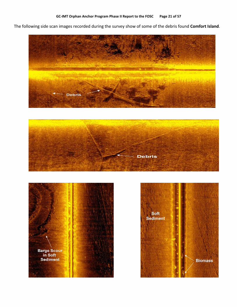
GC-IMT Orphan Anchor Program Phase II Report to the FOSC Page 21 of 57 The following side scan images recorded during the survey show of some of the debris found Comfort Island.

GC-IMT Orphan Anchor Program Phase II Report to the FOSC Page 22 of 57
Cat Fish Pass is an example of where boom was set in an area of oyster leases that showed little debris and no anchors.
Dry Bread Island was only citable example of where boom may have been stranded. The spacing between anchors at the upper left is approximately 350 feet.
Anchor Signatures GREEN Dots
Other Debris RED Dots
Dry Bread Island
350 foot spacing

GC-IMT Orphan Anchor Program Phase II Report to the FOSC Page 23 of 57 St. Bernard Division 5 results are shown in the following figure and summarized in the table below.
St. Bernard Parish Div. 5

GC-IMT Orphan Anchor Program Phase II Report to the FOSC Page 24 of 57
Jefferson Parish Division 1 – A Consolidated Bottom Environment Clear of Anchor Signatures A limited search was conducted in Jefferson Division 1 to test a consolidated sandy bottom environment. The same process was used to set out search patterns and 10 search grids were selected. The clearing searches identified 58 ferrous objects for further investigation. All 58 of those objects were eliminated during the target ID searches. The bottom profile in Jefferson Parish is a sandy bottom characterized by consolidated sediment showing almost zero meters of penetration when probing to refusal. No anchor signatures were identified in the area, likely due to this bottom condition and the use of proper anchor tackle.
MapLocation
#General Location Start End
Cle
ared
Dat
e
Boo
m ft
Ferr
ous
Targ
ets
Pot
entia
l A
ncho
rs
Elim
inat
edD
urin
g ID
Dep
th (m
) to
Con
solid
atio
n
Anc
hor
Sig
natu
re
Notes
5-1 Comfort Island 29°49'46.00N 89°15'55.00W
29°49'46.00N 89°14'35.00W 40640 14852 244 78 43 2.1 NA
100's of targets of all strengths. No visible anchors. Too shallow in
5-2 Dry Bread Island 29°50'56.00N
89°18'29.00W29 50'17.00N89 17'46.00W 40641 10928 31 19 11 2.2 8 Too shallow and submerged
5-3 Drum Bay Island 29°55'16.50N 89°15'55.00W
29°55'16.50N89° 15'35.00W 40646 5037 27 11 10 2 1 Too shallow. < 2' water.
5-4 Treasure Pass 29°49'34.00N 89°25'20.00W
29°49'37.00N 89°25'15.00W 40644 1152 0 0 0 x 0 Off Priority Listing(Cptn Casey)
5-5 Sample Island Pass 29°52'31.00N 89°15'39.00W
29°52'36.00N 89°15'25.00W 40646 1580 22 16 15 2.2 1 submerged
5-6 West South Canal 29°49'24.00"N 89°19'13.37"W
29°49'39.00"N 89°19'23.00"W 36995 1640 58 11 9 2 2 submerged
5-7 North end of Canal 29°50'22.35"N 89°19'28.19"W
29°50'27.77"N 89°19'22.32"W 40647 1444 7 4 4 2 0 4: cleared < 2' water
5-8 Pipeline Pass 29°50'14.72"N 89°23'42.62"W
29°50'20.74"N 89°23'32.27"W 40644 2815 0 0 0 x 0 Off Priority Listing(Cptn Casey)
5-9 Scow Pass 29° 52.388'N 89° 16.482'W
29° 52.405'N89° 16.160'W 40642 732 27 12 11 2.1 1 SS images show entanglement.
5-10 Keelboat Pass West 29° 53.037'N 89° 15.309'W
29° 53.005'N89° 15.258'W 40642 75 2 0 0 x 0 Zero contacts
5-11 Keelboat Pass East 29° 53.007'N 89° 14.572'W
29° 53.054'N89° 14.489'W 40642 808 1 0 0 x 0 Zero contacts
5-12 White Log Lake North 29° 51.254'N 89° 19.337'W
29° 51.304'N89° 19.138'W 40642 1154 14 4 3 2 1 ruled out. < 2' water
5-13 White Log Lake South 29° 50.918'N 89° 19.706'W
29° 51.024'N89° 19.434'W 40644 979 17 5 4 2 1 All potential anchors ruled out
5-14 Skiff Lake North 29° 52.065'N 89° 18.663'W
29° 52.130'N89° 18.486'W 40644 1282 11 2 2 2.1 2 Outside Signature
5-15 Skiff Lake South 29° 51.858'N 89° 18.533'W
29° 51.860'N89° 18.381'W 40644 1018 7 3 3 2 0 < 2' water.
5-16 Bayou De Soto 29° 53.397'N 89° 21.606'W
29° 53.373'N89° 21.538'W 40647 329 3 2 2 1.8 0 > 3' of unconsolidated
5-17 Bayou Julia West 29° 52.783'N 89° 21.391'W
29° 52.652'N89° 21.153'W 40647 581 10 2 2 2.2 0 > 3' of unconsolidated
5-18 Bayou Julia East 29° 52.640'N 89° 20.507'W
29° 52.707'N89° 20.390'W 40644 589 22 10 10 2.3 0 All outside Mag. Signatures
5-19 Bayou Julia South 29° 52.235'N 89° 19.913'W
29° 52.254'N89° 19.772'W 40647 778 10 2 2 1.8 0 Target in 12' water. 3+ feet of
unconsolidated sediment
5-20 Catfish Pass 29° 53.713'N 89° 20.709'W
29° 53.621'N89° 20.499'W 40644 2212 14 7 7 2 0 Shallow & outside signature
5-21 Deadman Bayou 29° 55.423'N 89° 17.154'W
29° 55.438'N89° 17.100'W 40646 367 27 4 3 2 1 Data shows submerged
5-22 Work Order #22 x x 40644 213 0 0 0 x Off Priority Listing(Cptn Casey)
5-23 Work Order #23 C. Casey C. Casey 40646 613 13 4 4 2.2 0 outside signature
5-24 Work Order #24 C. Casey C. Casey 40646 3096 17 8 7 2.2 1 Cleared
5-25 Work Order #25 C. Casey C. Casey 40646 1117 9 3 3 2 0 Outside scope of magnetics
55391 593 207 155 2 19
Orphan Anchor Phase II Search Results: St. Bernard Parish Division 5

GC-IMT Orphan Anchor Program Phase II Report to the FOSC Page 25 of 57
As required by the Archeological Resources and Protection Act of 1979, and the National Historic Preservation Act of 1966, as amended, the raw and processed data from the survey will be transferred to the State of Louisiana for security of information purposes. As well the State may take the opportunity to assess the thousands of ferrous objects found that were not anchors for potential hazards to navigation and risk to commercial and private fishing. A copy of this data will be maintained on the GIS database server bp1xtxdb081-c as required by the legal hold order.
Map Location General Location Start End END LAT End LON AssignmentDescription
Cent
erlin
e M
easu
rem
ent f
eet
Offse
t Rati
o
Total
Boo
m F
eet
High
Spe
ed S
urve
y Da
te
Low
Spee
d Sur
vey
Date
Total
V1T
arge
ts
V2 E
limin
ated
Anch
or S
igna
ture
Survey Notes1. Water <2 ft2. buried >3 ft
Div 2-1 Grand Isle Jetty 29.200125°,-90.039392°
29.193262°,-90.039034° 29.193262°,-90.039034° High traffic 2446 1.5 3669 x x 14 14 0
Div 2-2 Grand Isle Channel west
29.192515°,-90.044953°
29.182935°, -90.046385° 29.182935°, -90.046385° High traffic 3502 1.5 5253 x x 20 20 0
Div 2-3 Back Bay 29.204297°,-90.056100°
29.201246°,-90.054873°
29.201246°,-90.054873° High traffic 1182 1.5 1773 x x 13 13 0 1
Div 2-4 Caminada Bay Southwest
29.212957°,-90.095618°
29.207491°,-90.095528°
29.207491°,-90.095528° High traffic 1947 1.5 2921 x x 6 6 0
Div 2-5 Bay Lizette South 29.248914°,-90.095914°
29.253077°,-90.103248°
29.253077°,-90.103248° High traffic 2778 1.5 4167 x x 5 5 0
Div 2-14 Grand Ilse Pass East
29°15'49.67"N, 89°56'53.84"W
29°15'36.69"N, 89°56'32.97"W
29;15;36.69 N 089;56;32.97 W High traffic 2270 1.5 3405 x x 0 0 0 40' depth - too deep to survey
Div 2-15 Grand Ilse Pass East
29°16'15.88"N, 89°56'37.47"W
29°15'58.55"N, 89°56'36.73"W
29;15;58.55 N 089;56;36.73 W High traffic 1717 1.5 2576 x x 0 0 0 40' depth - too deep to survey
Div 2-16 Grand Terre Pass 29°17'34.64"N, 89°54'13.90"W
29°16'53.44"N, 89°54'18.87"W
29;16;53.44 N 089;54;18.87 W High traffic 4181 1.5 6272 x x 0 0 0 40' depth - too deep to survey
Div 2-23 Queen Bess Island 29°18'6.25"N,
89°57'49.57"W29°18'6.25"N,
89°57'49.57"W
High traffic/Rookery Boom circled island 8742 1.5 13113 x x 0 0 0
Div 2-24 Grand Ilse Channel
29°12'55.04"N, 90° 2'51.86"W
29°13'6.70"N, 90° 2'41.98"W
29;13;06.70 N 090;02;41.98 W High traffic 1468 1.5 2202 x x 0 0 0
30233 Total Boom Ft 45350 100% 100% 58 58 0
Jefferson Parish Division 1 Trials
Jefferson Parish Division I

GC-IMT Orphan Anchor Program Phase II Report to the FOSC Page 26 of 57 Key Findings
• Fewer anchor targets were identified than anticipated. Those located were found in areas consistent with the original boom placement.
• Anchor targets were found buried at an average depth of 1.9 – 2.1 meters, where the risk of damage to personal and commercial vessels is extremely low.
• The anchor targets were generally located where the very soft, unconsolidated surface sediments met more consolidated and competent bottom conditions.
• Deep burial of Danforth anchors, in soft bottom conditions, is consistent with how the anchors are designed to perform.
• No free-floating polypropylene rope was identified over the course of the project. • To date, there have been no documented reports of vessel incidents with orphan anchors. • The degradation of the anchor material (steel and galvanized steel) poses no significant threat to
human health or the environment. • Because the anchor targets were found buried so deep, no attempts were made to recover them due
to personal safety and the NEBA associated with removal of the over-burden sediment. • Over the course of Phase I, it was evident that the technology utilized to locate the placed anchors was
extremely effective. That same technology, coupled with algorithms developed to make it more effective, was applied to Phase II in an effort to find the greatest number of anchors.
• The technology employed for detection of orphan anchors in the surveyed area was successful in locating orphan anchors (46) as well as a very large number (1157) of other ferrous objects, which the State of Louisiana should consider reviewing as they may pose a hazard to navigation and risk to commercial and personal vessels (the comprehensive search data should be provided to the State of Louisiana for review and for security of information).
Conclusions
The Orphan Anchor Survey Phase II investigation clearly answered the questions raised in the NEBA by showing that there were far fewer anchors left behind than expected and that those found were buried in sediment. No evidence of floating polypropylene rope was found in any of the locations surveyed. The Orphan Anchor Survey verified that orphan anchors in St. Bernard are deeply buried in soft deltaic sediments. These anchors are unlikely to be re-exposed, dislodged and moved shoreward. Anchors are small, compact, heavy objects that have a small cross sectional area – they are heavy for their size. If the same amount of steel were to be reformed into another shape, for example a barrel or box shape, it would weigh the same but have a much larger cross sectional area, which would make it subject to being moved by wave action. Because waves disturb the bottom by suspending sediments in the water column, an anchor is likely to migrate further downward vertically in the sediments in which it is buried than to be transported horizontally.

GC-IMT Orphan Anchor Program Phase II Report to the FOSC Page 27 of 57 Appendix A – Pre-Survey Net Environmental Benefit Analysis (NEBA)
18 March, 2011
Prepared for Capt. Hanzalik, FOSC and Tom Zimmer, BP IC by
L. Bruce, A. Maki, B. Wood, M. Taylor, T. M. Garrett, J. Burns, J. Hokanson
Executive Summary
The purpose of this report is to provide the Federal On-Scene Coordinator (FOSC) for the Deepwater Horizon MC252 Spill of National Significance with a risk-based Net Environmental Benefits Analysis (NEBA) associated with removing remaining anchors used to secure oil booms. Three alternative actions were considered: 1) Leave the anchors in place, 2) locate and identify the anchors using remote sensing techniques, and 3) locate, salvage and remove the anchors from the sea bottom.
Alternative 1: Results from the Phase I Orphaned Anchor Identification Program indicate that there were fewer anchors left in place than previously envisioned. Empirical data from that investigation also show that five of the six anchors placed in the study area were completely buried beneath the sediment within ten days of their placement on the water bottom. Leaving the anchors in place posed the lowest overall environmental and human health risk. However when specific geographic areas were evaluated in detail, certain risks such as potential hazard to navigation, commercial fishing and recreational use were higher. Therefore, although the overall risk of leaving anchors in place is low, consideration should be given to reconnaissance location surveys in higher risk areas. These surveys could be performed on a priority basis. Alternative 2: Locating and identifying anchors also presented a relatively low level of environmental and human health risk. However medium risk existed for marine personnel in conducting the operations. The overall level of risk would depend upon the level of effort and extent of operations. Modest reconnaissance style operations in prioritized targeted areas would pose minimal risks. A limited reconnaissance effort may provide additional data to evaluate whether or not further efforts may be warranted.
Alternative 3: Salvage and removal of the anchors from the sea bottom posed the greatest risk of the three alternatives. Although the composite risk for any given category did not exceed “medium” because of the low probability of occurrence, the consequential risk of some of these categories was substantial if an incident were to occur. This alternative shows the highest risk and most dangerous consequences of the three.
Net Environmental Benefits Analysis
Statement of the Problem – During the DWH Oil Spill Response period in summer 2010, numerous Vessels of Opportunity (VOOs) were employed by BP to place oil spill boom in nearshore areas to prevent oiling of sensitive shorelines. Typically a length of boom was anchored at one end then deployed over the transom and a second anchor was deployed at the end of the boom length. Boom was supplied from numerous sources and thus a wide variety of boom sizes, shapes, colors and lengths were deployed. This program resulted in approximately 3.8 million linear feet of containment boom placed along Gulf of Mexico shores of which approximately 2.0 million linear feet were employed in Louisiana waters. Accordingly, an undetermined number of anchors held this boom in place.

GC-IMT Orphan Anchor Program Phase II Report to the FOSC Page 28 of 57
Figure 1 Photograph of deployed boom that would require anchors to hold in place.
Once free oil was removed from the water surface and no longer posed a threat for oiling shorelines, a program to collect the boom was implemented. The VoOs were dispatched to collect the boom. Although most boom anchors were collected at that time, some of the VoO operators, likely due to the size and capability of their vessels, were unable to recover some of the anchors. Inventories have been conducted to try to determine how many anchors were left on the sea bottom, where the “orphaned” anchors may be located, and whether or not they pose any risks to ecological resources, human health and vessel navigation.
Efforts from the Orphaned Anchor Identification and Recovery Pilot Program Phase 1 yielded the following information. During operations to recover the boom, every anchor that could be found and recovered was removed with the boom. There were two circumstances in which some anchors were not recovered:
1. anchors that were no longer attached to the boom, a circumstance that made it impossible at the time to know the location of the anchor, and
2. anchors that were attached to the boom but buried so deeply in the sediment as to make recovery unreasonable or impossible
The pilot program also demonstrated that with the appropriate combination of equipment, anchors resting on the surface of the sediment can be detected but with significant limitations:
• the technology demonstrated to be effective at identifying anchors is only usable in water depth of four feet or more,
• there is infrastructure in the coastal waters and a large volume of ferrous material that interfere with the successful identification of orphaned anchors even when using the most effective technology, and

GC-IMT Orphan Anchor Program Phase II Report to the FOSC Page 29 of 57
• three percent or less of the objects detected by even the most effective technology were proven to be anchors.
The removal of the test anchors proved to be a difficult task. Only four of the six test anchors were successfully retrieved using conventional retrieval tools. Five of the six anchors were completely buried beneath the sediment within ten days of their placement on the water bottom. NEBA Methodology – During the Exxon Valdez Oil Spill (EVOS) in 1989 a decision making process was developed to assist in identifying relative risks of clean-up alternatives including the no-action alternative. The process identified the ecological and human health risks associated with an action and then provided a basis to develop a comparison of risks with other alternatives. Using this comprehensive identification of the ecological and human health risks approach allowed for a science-based identification and ultimate selection of the least harmful clean-up alternatives. This study evaluates the risks of certain alternative actions and places them in a matrix for comparison. Recommendations based on the relative risks are summarized in conclusion.
NEBA for Boom Anchor Removal -This study was designed to assess the relative risks comparing the alternatives of boom anchor removal vs. the option of leaving these anchors in place by conducting a Net Environmental Benefits Analysis (NEBA). Specifically the questions addressed by this NEBA are:
1. What, if any, are the risks to human health, the environment, and public safety if the remaining anchors are left in place?
2. What, if any, are the risks to human health, the environment, and public safety in employing various means in locating and identifying the remaining anchors?
3. What, if any, are the risks to human health, the environment, and public safety in removal operations for the remaining anchors?
Alternatives Analysis:
(1). Leaving the Remaining Anchors in Place
The risk factors posed by leaving the anchors in place are the ecological and human health risks associated with the slow rust and decay of the anchors and the physical risk of hazard to navigation as well as commercial fishing and recreational activities. Most of the anchors used are standard galvanized Danforth anchors composed of zinc galvanized Iron.

GC-IMT Orphan Anchor Program Phase II Report to the FOSC Page 30 of 57
Danforth schematic. Note 30 degree angle on shank.
Photos of Danforth anchors. Shank rises maximum of thirty degrees from horizontal when deployed. This encourages the flukes to dig in and hold rather than slide along the bottom. The anchors are designed to lay flat in storage or if free from chain or rode to avoid creating a hazard.
Ecological and Human health risk of zinc and iron
Zinc
Zinc is naturally present in seawater and is considered an essential dietary mineral necessary for human health. Zinc is present in surface waters largely from naturally occurring deposits in the earth’s crust but it is also present as a result of industrial wastewater discharges from galvanic industries, battery production etc. The average zinc concentration in seawater is 0.6 – 5 parts per billion. Rivers generally contain between 5 and 10 parts per billion. Algae contain as much as 20-700 parts per million, sea fish and shells contain 3-25 parts per million, oysters contain 100-900 parts per million and lobsters contain 7-50 parts per million. The World Health Organization states that there is no health based limit required for zinc in drinking water. However, there is an aesthetic limit for zinc in drinking water of 5 parts per million because of taste. Thus elemental zinc is generally not considered a hazard to human health or the environment.
Ecotoxicological tests indicate that a predicted no effect concentration is 150 to 200 parts per billion. This is considered to be the concentration at which no environmental effects occur. The human body contains approximately 2-3 grams of zinc; and the mineral zinc has dietary value as a trace element. Its functions

GC-IMT Orphan Anchor Program Phase II Report to the FOSC Page 31 of 57 involve mainly enzymatic processes and DNA replication. The human hormone insulin contains zinc. The minimum daily intake is 2-3 grams, at which level it prevents deficiencies.
The low toxicity of zinc to humans and aquatic life and the fact that it is an essential trace mineral for humans, all indicate the risks from exposure to the small amount of zinc that may be slowly released from rusting anchors in the nearshore environment are extremely low. At this stage of the NEBA, there are no significant ecological or human health risks from potential exposure to zinc resulting from leaving the anchors in place.
Iron:
Iron is one of the most abundant metals on earth and is considered essential to most life forms including humans. Iron is generally considered not soluble in water, particularly seawater, because when iron contacts water the normal product is rust particles. However, in very low concentrations, iron may occur in freshwater in two forms: either the soluble ferrous iron or the insoluble ferric iron. Freshwater containing ferrous iron is clear because the iron is dissolved. When exposed to air or atmosphere (oxygen), the water turns cloudy and a reddish brown substance begins to form. This sediment is the oxidized (rust) or ferric form of iron that dissolves in water only at very low concentrations.
Rivers contain 0.5 to 1 part per million iron naturally. Oxygen in the water limits the concentration. Some groundwater with low oxygen levels may contain approximately 100 parts per million. Seawater contains 1 to 3 parts per billion iron naturally. The amount varies by area and depth because of available oxygen in seawater and because iron is an essential nutrient for life that is quickly taken up by plankton and other sea life when it is available. Most algae naturally contain between 20 and 200 parts per million iron and some brown algae may contain up to 4,000 parts per million. Iron is part of their life chemistry. Iron occurs naturally in many seafoods such as tuna, halibut, shrimp and oysters, and in terrestrial foods such as chicken, pork and beef.
In humans, iron is a central component of hemoglobin in the blood. One pint of blood contains approximately 250 milligrams of iron which binds oxygen and transports it from the lungs to other body parts. It then transports CO2 back to the lungs. People with low iron levels in their blood are called anemic and they may be treated with iron supplements. Iron is considered a vitamin supplement for children under 6 years old and is vital to some brain and memory functions. Like all chemicals, iron can be toxic if ingested in extreme overdose or in some chemical forms not common in nature.
Iron is not classified as a priority pollutant because of its low toxicity to sea life in water and sediments. Thus at this stage of the NEBA analysis we conclude that the human health and ecological risks from rusting anchors on the sea bottom are considered insignificant.
Physical risks of Hazard to Navigation
Mr. Tim Boriski and Mr. David Ledet with US Coast Guard Eighth District in New Orleans were interviewed to help define and evaluate hazards to navigation. The following information was provided: A Hazard to navigation is an obstruction, usually sunken, that presents sufficient danger to navigation so as to require

GC-IMT Orphan Anchor Program Phase II Report to the FOSC Page 32 of 57 expeditious, affirmative action such as marking, removal, or redefinition of a designated waterway to provide for navigational safety (33CFR part 245.5).
Additionally, in determining whether an obstruction is a hazard to navigation for the purposes of marking, the District Commander considers, but is not limited to, the following factors: (a) Location of the obstruction in relation to the navigable channel and other navigational traffic patterns; (b) Navigational difficulty in the vicinity of the obstruction; (c) Depth of water over the obstruction, fluctuation of the water level, and other hydrologic characteristics in the area; (d) Draft, type, and density of vessel traffic or other marine activity in the vicinity of the obstruction; (e) Physical characteristics of the obstruction; (f) Possible movement of the obstruction; (g) Location of the obstruction in relation to other obstructions or aids to navigation; (h) Prevailing and historical weather conditions; (i) Length of time that the obstruction has been in existence; (j) History of vessel incidents involving the obstruction; and (k) Whether the obstruction is defined as a hazard to navigation under other statutes or regulations. (33CFR part 64.31). Also under 33CFR part 64, the owner of a wreck or obstruction is responsible/liable for marking and removing said wreck or obstruction.
In light of these definitions, unless the precise location of an orphaned anchor is specified, and it is in a shallow navigation way, a hazard to navigation determination cannot be made.
Physical Risk to Commercial Fishing
Louisiana Department of Wildlife and Fisheries data indicate that are approximately 40,000 commercial shrimp trips and 32,000 oyster trips per year in state waters. Some commercial shrimpers may use “butterfly nets” where the boat is primarily stationary letting the current bring the shrimp. Some use “otter nets” where the boat deploys nets to trawl actively at or near bottom. Some otter nets may use “rollers” or “rockhoppers” at the bottom of the net that allow the nets to roll or jump some obstacles on the sea bottom as shown below.
Illustrations of shrimp boat with nets deployed and of rollers and rockhoppers at bottom of nets.

GC-IMT Orphan Anchor Program Phase II Report to the FOSC Page 33 of 57 Of the shrimp trips, approximately 29,000 per annum use “skimmer” nets in shallow water along the shoreline or banks. Skimmer nets are usually deployed from small boats and the net consists of a top bar holding the net and two vertical bars on either end to extend the net downward. There is no bottom bar on the net because lead lines are used to weight the bottom. Occasionally the furthest vertical bar from the boat is shorter than the near bar to allow for slope of the bottom toward the bank.
Oysters are harvested with an oyster dredge consisting of open top box with beveled teeth on one open side and a heavy duty bag or net attached to gather the oysters. Of necessity, shrimp and oyster trawls or dredges proceed at slow speeds.
Physical Risk to Recreational Fishing and other Recreation
In Louisiana recreational boaters and fishermen seldom use nets as described above. When they do there are restrictions regarding net size (16 foot), size of catch (100 pound daily limit) and use of catch (cannot be sold).
Both recreational boating and recreational hook and line fishing are popular and important to the State of Louisiana. In 2008 the Louisiana Department of Wildlife and Fisheries sold 483,591 marine recreational fishing licenses. These shallow water activities, both private and charter, are conducted in waters as shallow as two feet and done from boats ranging from eight to thirty feet in length. Speeds of these vessels range from trawling to transit speeds in excess of 40 knots. If a recreational or charter vessel, while being operated in compliance with commonly accepted practice and regulations, were to become entangled with an anchor kit (anchor, chain or polypropylene rope) a potential outcome could be an injury or disabling of a vessel in a remote area. Because the Phase I study indicated that five out of six anchors in the study area were buried beneath the sea bottom within 10 days of placement the NEBA team has assigned the overall level of potential hazard by the anchors to commercial fishing and recreation as medium, with a probability of low. However, efforts to check for or locate anchors in areas that could be of greater hazard, such lanes of boat traffic that are in known Response boom deployment areas, should be considered on a priority basis.
The risk ratings for navigational hazards from leaving anchors in place are given by category in the final risk matrix (Table 1) below.
NEBA Conclusions from Leaving Anchors in Place
The overall composite risk of leaving the anchors in place is medium to low. However, the potential hazard level and risk may vary considerably by location and activity. The consequential risk of a recreational boater hitting an anchor is higher than that of commercial fishing. Although the overall risk is medium to low, consideration should be given for a reconnaissance effort to locate and identify anchors in areas of greater potential hazard such as lanes of boat traffic that are in known Response boom deployment areas. A reconnaissance effort may provide an indication of whether or not further efforts may be warranted.
(2.) Locating and Identifying Anchors
Acoustic and magnetic methods have been tested for locating and identifying anchors. The acoustic method uses a bow mounted high-frequency side scan. The magnetic method uses a marine magnetic gradiometer.

GC-IMT Orphan Anchor Program Phase II Report to the FOSC Page 34 of 57 The side scan sonar is an active detection system that emits an acoustic pulse into the water column. The acoustic pulse travels outward and is reflected by objects in the water column, the seabed, and objects on the seabed. The pulses emitted by the side scan sonar are at frequencies of 600 kilohertz and 1.2 gigahertz. The high frequencies of the side scan sonar result in very rapid attenuation of the signal. The side scan sonar is bow mounted above the water-line. The rapid attenuation of the side scan sonar signal combined with the operational restriction of terminating the side scan sonar use when marine mammals are present result in a low risk of acoustic interference with marine mammals and a low probability of occurrence. Because the side scan sonar is positioned above the waterline, and because very shallow water areas are avoided, the risk of habitat disturbance by the side scan sonar system and the probability of habitat disturbance are considered low.
The marine magnetic gradiometer is a passive system that measures the ambient magnetic field. Magnetic fields generated by objects and the distortion of the earth’s natural magnetic field by ferrous objects are sensed by the gradiometer and used to determine the location of ferrous objects.
Because the gradiometer is a passive instrument that is towed just below the water surface, the risk of habitat disturbance and probability of occurrence are considered very low.
An accurate determination of the height of the gradiometer above the seabed is required to process the marine gradiometer data. Therefore the marine magnetic gradiometer is equipped with an acoustic 200 kilohertz single-beam echo sounder. Because of the high frequency, rapid attenuation and low output of the echo sounder, the probability of occurrence and risk of acoustic interference with marine mammals are low.
The weight, size and deployment method of the gradiometer pose a medium risk to personnel over the long run. Although precautions have been taken regarding personnel, and an electric winch is used to lift the gradiometer out of the water, the gradiometer is fairly large and heavy in air, and must be deployed and retrieved at the start and end of a survey. The probability of an incident occurring is low due to procedures in place for deployment and recovery of the gradiometer.
The risk ratings for locating and identifying anchors are given by category in the final risk matrix below (Table 1).
NEBA Conclusions to locating and identifying anchors
Locating and identifying anchors indicate a relatively low level of environmental and human health risk. However a medium risk exists for marine personnel conducting the location operations. The overall level of risk would depend upon the level of effort and extent of operations. Modest reconnaissance style operations in prioritized targeted areas would pose minimal risk. A limited reconnaissance effort may provide additional data to evaluate whether or not further efforts would be warranted.
(3). Location, Salvage and Removal of Anchors from the Sea Bottom
Salvage and Removal - The consequence risks and probability of an incident occurring are illustrated in the risk matrix. These are simply graded as High (H), Medium (M) or Low (L). The risks and probabilities are based on

GC-IMT Orphan Anchor Program Phase II Report to the FOSC Page 35 of 57 professional judgment of the NEBA team members and based on the premise of utilizing a competent contractor with marine equipment and cranes audited by an approved and competent BP auditor.
The orphaned anchors will have been previously located, marked and verified by a BP furnished competent survey contractor. At each location where orphaned anchor salvage is required, a hazard survey will have been performed by the BP furnished competent survey contractor. The hazard survey will identify the following: pipelines, flowlines, wells, communications cables, electric cables, unexploded ordinance, items and objects of historical/archaeological importance, oyster beds, etc.
For each of the four hazards: Snag a pipeline, snag an oil line, damage an abandoned well or encounter unexploded ordinance, the consequential risks are high. This indicates that if this hazard was to occur, the consequential risks associated with that encounter are high and would likely result in oil spills of some magnitude or a potential explosion in the case of unexploded ordinance. However if the proper survey procedures are followed as detailed above, the probability of encountering any one of these hazards would be very low i.e. the marine survey would have pin-pointed the exact location of pipelines, supply lines and wells so that the anchor retrieval process would stay clear of those areas. This then results in the composite risk rating of Medium for these four potential hazards.
Similarly the consequential risks associated with encountering a communications cable are judged to be a bit lower than an oil line and are classed as medium since no oil spill would result, however there could be a disruption of communications served by the cable. But again assuming a detailed marine survey was conducted, the location of all cables will be known and the probability of encounter would be low thus resulting in a medium composite risk rating.
The consequential risks to the benthic marine habitat are considered low since there would likely be some localized disruption of the marine sediments in the immediate area of the of the retrieval efforts but the probabilities of any meaningful risks to localized biota are considered to be low thus resulting in a medium composite risk rating.
Similarly the risks to marine operations personnel are considered medium due to the potential injury types that could occur during the retrieval operations (slips, trips, falls) or overboard risks. But again the probability of these risks is considered to be low since operations will be conducted by experienced, trained personnel. This results in the medium composite risk rating. The risk ratings for salvage and removal of anchors are given by category in the final risk matrix below (Table1).
Analysis for Submerged Cultural Resources During Salvage Operations
HDR/SEARCH, Inc. cross-referenced Louisiana archaeological databases and numerous shipwreck databases with the derived boom locations in a GIS environment. Terrestrial archaeological databases included the Louisiana Archaeological Site File and newly discovered sites post MC252 (surveyed by HDR, Inc.). The offshore databases included NOAA’s Automated Wreck and Obstruction Information System (AWOIS); NOAA’s ENC Direct to GIS for the Gulf of Mexico Region, which is a service providing nautical chart information for download; the Bureau of Ocean Energy Management, Regulation and Enforcement (BOEMRE) Historic Shipwrecks database; the U.S. Coast Guard shipwreck database; the U.S. Navy shipwreck database; the Global Maritime Wrecks Database (GMWD); and two private databases created by Garrison and Coastal

GC-IMT Orphan Anchor Program Phase II Report to the FOSC Page 36 of 57 Environments, Inc. (CEI). HDR/SEARCH, Inc. generated 150-meter buffers around all potential site locations and determined which mapped boom locations intersected these buffers. Only four known Louisiana sites are within 150 m of originally placed booms. Only one offshore site is within 150 m of an originally placed boom.
With such a small number of recorded resources the probability of encountering submerged cultural resources at the derived boom locations is low and the risk of impacting those resources if boom anchor removal operations move forward is also low.
NEBA Conclusions from salvage and removal of anchors from the sea bottom
As shown in the final risk matrix below, salvage and removal of the anchors from the sea bottom poses the greatest risk of the three alternatives. Although the composite risk for any given category did not exceed “medium” because of the low probability of occurrence, the consequential risk of some of these categories was substantial if an incident were to occur. The highest risk and most dangerous consequences lie with the salvage and removal alternative. It is not recommended unless located and identified anchors are in a very high risk geographic area.
Table 1. Risk Matrix for the three action alternatives:
Action Consequential Risk Low/Medium/High
Probability Low/Medium/High
Composite Risk Rating L = Green; M = Yellow;
H = Red (1.) Leave Remaining Anchors
Toxicity of Fe and pathways L L Low Toxicity of Zn and pathways L L Low Navigation hazard/ Commercial Fishing/ Recreational Use
M L Medium
(2.) Locating and Identifying Anchors
Acoustic on Mammals L L Low Risk to personnel of Marine Operations
M L Medium
Disturb Habitat L L Low (3.) Salvage and Removal of Anchors from sea bottom
Snag a pipeline (cause leak) H L Medium Snag oil line from well to TB H L Medium Damage abandoned oil well H L Medium Damage communication Cable
M L Medium
Unexploded Ordinance H L Medium Disturb Marine Archeology L L Low Disturb Habitat L L Medium Risk to personnel of Marine operations
M L Medium

GC-IMT Orphan Anchor Program Phase II Report to the FOSC Page 37 of 57 Conclusions: Three alternative actions were considered: 1) Leave the anchors in place, 2) locate and identify the anchors using remote sensing techniques, and 3) locate, salvage and remove the anchors from the sea bottom. Alternative 1: Results from the Phase I Orphaned Anchor Identification Program indicate that there were fewer anchors left in place than previously envisioned. Empirical data from that investigation also show that five of the six anchors placed in the study area were completely buried beneath the sediment within ten days of their placement on the water bottom. Leaving the anchors in place posed the lowest overall environmental and human health risk. However when specific geographic areas were evaluated in detail certain risks such as hazard to navigation, commercial fishing and recreation were higher. Therefore, although the overall risk of leaving anchors in place is low, consideration should be given to reconnaissance location surveys in higher risk areas such as lanes of high boat traffic that cross known areas of booms. These surveys could be performed on a priority basis. Alternative 2: Locating and identifying anchors also presented a relatively low level of environmental and human health risk. However medium risk existed for marine personnel in conducting the operations. The overall level of risk would depend upon the level of effort and extent of operations. Modest reconnaissance style operations in prioritized targeted areas would pose minimal risks. A limited reconnaissance effort may provide additional data to evaluate whether or not further efforts may be warranted. Alternative 3: Salvage and removal of the anchors from the sea bottom posed the greatest risk of the three alternatives. Although the composite risk for any given category did not exceed “medium” because of the low probability of occurrence, the consequential risk of some of these categories was substantial if an incident were to occur. This alternative shows the highest risk and most dangerous consequences of the three.

GC-IMT Orphan Anchor Program Phase II Report to the FOSC Page 38 of 57 Appendix B – Pre Recovery Net Environmental Benefit Analysis (NEBA)
Net Environmental Benefit Analysis for LA Orphan Anchors Team members: USCG: CDR Dan Norton, LTJG Tyler Stutin
NOAA: Frank Csulak, Toni Debosier, Karla Reece, David Dale USFWS: Janice Engle State of LA: Phil Bowman, Mike Algero Historic Preservation: Larry Murphy BP: John Nepywoda, Lyle Bruce, Brian Wood
Purpose: The purpose of this report is to provide the Federal On-Scene Coordinator (FOSC) with a Net Environmental Benefit Analysis (NEBA) associated with removing orphan anchors from the waters of the state of LA which were deployed during the response to the Deepwater Horizon MC252 Spill of National Significance. The question for this NEBA is which response option provides for the greatest net environmental benefit when considering that recovery operations will have some adverse environmental impacts. It is noted that the State of Louisiana stated their expectation that the anchors used during the response be removed. Geographic area of concern: The areas of concern in general for this analysis include selected tidal waters in Louisiana where oil boom was placed during the oil spill response, and specifically those waters of St. Bernard, Jefferson, Terrebonne, Lafourche and Plaquemines Parishes. The specific inland bays, passes, and waterways were selected due to their shallow water and higher vessel traffic volume which presented the highest risk for hazards to navigation, and are identified in the Orphan Anchor Phase II Program Report to the Federal On Scene Coordinator. The Mississippi River delta plain with its associated wetlands and barrier shorelines are characterized as the product of the continuous accumulation of sediments deposited by the river and its distributaries. Regular shifts in the river's course have resulted in four ancestral and two active delta lobes, which accumulated as overlapping, stacked sequences of unconsolidated sands and mud. As each delta lobe was abandoned by the river, its main source of sediment, the deltas experienced erosion and degradation due to compaction of loose sediment, rise in relative sea level, and catastrophic storms. Marine coastal processes eroded and reworked the seaward margins of the deltas forming sandy headlands and barrier beaches. As erosion and degradation continued, segmented low-relief barrier islands formed and eventually were separated from the mainland by shallow bays and lagoons. The Louisiana coastal region is transited by recreational and commercial vessels including shrimp boats, fishing vessels, duck hunters, and more. Anchor Characterization: Much background work on characterizing the anchor issues and with identifying possible anchor locations has been completed under two previous studies developed for the FOSC. The following characterization and ecological and human health risk information is provided from the NEBA for Boom Anchor Removal dated March 18, 2011. The potential risks posed by leaving the anchors in place are the ecological and human health risks associated with the slow rust and decay of the anchors and the physical risk of hazard to navigation as well as commercial fishing and recreational activities. Most of the anchors used are standard galvanized Danforth anchors composed of zinc galvanized mild steel (which consists of iron and carbon).

GC-IMT Orphan Anchor Program Phase II Report to the FOSC Page 39 of 57
Photos of Danforth anchors. Shank rises maximum of thirty degrees from horizontal when deployed. This encourages the flukes to dig in and hold rather than slide along the bottom. The anchors are designed to lay flat in storage or if free from chain or rode to avoid creating a hazard. Ecological and Human health risk of zinc and iron
1. Zinc Zinc is naturally present in seawater and is considered an essential dietary mineral necessary for human health. Zinc is present in surface waters largely from naturally occurring deposits in the earth’s crust but it is also present as a result of industrial wastewater discharges from galvanic industries, battery production etc. The average zinc concentration in seawater is 0.6 – 5 parts per billion. Rivers generally contain between 5 and 10 parts per billion. Algae contain as much as 20-700 parts per million, sea fish and shells contain 3-25 parts per million, oysters contain 100-900 parts per million and lobsters contain 7-50 parts per million. The World Health Organization states that there is no health based limit required for zinc in drinking water. However, there is an aesthetic limit for zinc in drinking water of 5 parts per million because of taste. Thus elemental zinc is generally not considered a hazard to human health or the environment. Ecotoxicological tests indicate that a predicted no effect concentration is 150 to 200 parts per billion. This is considered to be the concentration at which no environmental effects occur. The human body contains approximately 2-3 grams of zinc; and the mineral zinc has dietary value as a trace element. Its functions involve mainly enzymatic processes and DNA replication. The human hormone insulin contains zinc. The minimum daily intake is 2-3 milligrams, at which level it prevents deficiencies. The low toxicity of zinc to humans and aquatic life and the fact that it is an essential trace mineral for humans, all indicate the risks from exposure to the small amount of zinc that may be slowly released from rusting anchors in the nearshore environment are extremely low. At this stage of the NEBA, there are no significant ecological or human health risks from potential exposure to zinc resulting from leaving the anchors in place.
2. Iron: Iron is one of the most abundant metals on earth and is considered essential to most life forms including humans. Iron is generally considered not soluble in water, particularly seawater, because when iron contacts water the normal product is rust particles. However, in very low concentrations, iron may occur in freshwater in two forms: either the soluble ferrous iron or the insoluble ferric iron. Freshwater containing ferrous iron is clear because the iron is dissolved. When exposed to air or atmosphere (oxygen), the water turns cloudy and a reddish brown substance begins to form. This sediment is the oxidized (rust) or ferric form of iron that dissolves in water only at very low concentrations. Rivers contain 0.5 to 1 part per million of iron naturally. Oxygen in the water limits the concentration. Some groundwater with low oxygen levels may contain approximately 100 parts per million. Seawater contains 1 to 3 parts per billion iron naturally. The amount varies by area and depth because of available oxygen in seawater and because iron is an essential nutrient for life that is quickly taken up by plankton and other sea life when it is available. Most algae naturally contain between 20 and 200 parts per million iron and some brown algae may contain up to 4,000 parts per million. Iron is part of their life chemistry. Iron occurs naturally in many seafoods such as tuna, halibut, shrimp and oysters, and in terrestrial foods such as chicken, pork and beef. In humans, iron is a central component of hemoglobin in the blood. One pint of blood contains approximately 250 milligrams of

GC-IMT Orphan Anchor Program Phase II Report to the FOSC Page 40 of 57
iron which binds oxygen and transports it from the lungs to other body parts. It then transports CO2 back to the lungs. People with low iron levels in their blood are called anemic and they may be treated with iron supplements. Iron is considered a vitamin supplement for children under 6 years old and is vital to some brain and memory functions. Like all chemicals, iron can be toxic if ingested in extreme overdose or in some chemical forms not common in nature. Iron is not classified as a priority pollutant because of its low toxicity to sea life in water and sediments.
Species and Habitat Overview: Endangered and threatened species or critical habitat under the jurisdiction of NMFS that may occur in or near the action area are sea turtles and Gulf sturgeon. Protected marine mammal species (dolphins and whales) may also occur in or near the action area. Vessel and in-water operations, including orphan anchor location and retrieval, may affect these animals either directly or indirectly through sound, physical contact, habitat alteration, and/or harassment. General habitat types occurring in the project areas include unvegetated and vegetated bottoms, oysters, and the water column. These habitat types have been identified and described as Essential Fish Habitat for federally managed species under the Magnuson-Stevens Fishery Conservation and Management Act. Unvegetated bottoms consist of sand, silt and mud and vegetated bottoms may support algae or rooted submerged aquatic vegetation such as Ruppia sp. and Halodule sp. Response Options:
1. Natural processes - Leave known orphan anchors in place to degrade via natural processes.
2. Least Invasive Methods – Includes: Shallow water Dive team recovery, Orange peel grapple.
3. Most Invasive Methods – Includes: Water based dredge, Propeller wash deflector device, Cofferdam. All three methods are deemed to be essentially equivalent in terms of expected impact to the marine environment for the purpose of this analysis.
Response Descriptions: 1. Natural processes - Anchor degradation via natural process. No mechanical or manual recovery is
performed.
2. Least Invasive Method Examples - Dive team recovery would utilize small boats and poles for finding anchors located in shallow water & sediments. Recovery of anchors in shallow waters once located would be via divers digging up the anchor when located no more than one foot (1’) in depth within the substrate. Orange peel grapple, Orange Peel Grapple picture and specification shown below. Requires crane and the orange peel grapple. Crane to have a 50-ton lifting capacity minimum and be capable of reaching past the side of the barge a minimum of 40-ft with the Grapple. Crane shall be capable of working the specified orange peel grapple in a maximum of 30-ft of water. Crane certification papers and load test information within the last 12-months to be furnished to BP. Orange Peel Grapple has a 0.75 yard capacity, is mechanical, and is operated with 2 wire ropes. Designed to allow mud and silt to escape while capturing orphaned anchors. Grapple to have an opening large enough to capture the anchor. Some modification may be required. This method is less invasive due to its ability to make a single grab or very limited number of grabs through the sediment to retrieve an anchor.

GC-IMT Orphan Anchor Program Phase II Report to the FOSC Page 41 of 57
3. Most Invasive Method Example - Water based grab dredge. A grab dredger picks up seabed material with a clam shell grab, which hangs from an onboard crane or a crane ship, or is carried by a hydraulic arm, or is mounted like on a dragline. This technique is often used in excavation of bay mud. Most of these dredges are crane barges with spuds. This method is considered more invasive due to the repeated grabs that are required to remove the overlying sediments and expose the object for recovery. The creation of a large depression in the sediment is necessary to ensure the depression walls remain stable in order to facilitate anchor recover.
Analysis Issues: To evaluate the options above, answers were sought for these questions:
a. Are there human health concerns in leaving the anchors in place?
b. If no further action is taken, what are the potential effects of the anchors to the environment?
c. Are there commercial or recreation vessel concerns?
d. Are there hazard to navigation concerns?
e. What does a Net Environmental Benefit Analysis (NEBA) justify?
Analysis Assumptions and Ranking Factors: See appendix (c). Analysis Results: See matrix. Based on this review, the following are the responses to the questions posed above:
a. Are there human health concerns in leaving the anchors in place?
There are no expected human health concerns due to the chemical composition or degradation of the zinc galvanized mild steel Danforth anchors.

GC-IMT Orphan Anchor Program Phase II Report to the FOSC Page 42 of 57
b. If no further action is taken, what are the potential effects of the anchors to the environment? If left in place the zinc galvanized mild steel Danforth anchors are expected to remain buried in the soft, muddy sediments and slowly oxidize. An anchor test conducted found that within ten days, the test anchors settled to a depth of 1.9 to 2.1 meters at the test site. The anchor test may not be representative of sediment conditions across the entire area of concern and, for example, anchors may have minimal penetration into sand sediments. The chemical composition and degradation of the metal anchors would be the primary concern, however the loading rate would be very small, and the area of impact would be small as well. The anchors are expected to present minimal environmental threat to the marine environment including wildlife due to the natural concentrations of zinc and iron present in the marine environment. Zinc based protection products are also widely used in marine applications and the addition of zinc to the environment from orphan anchors is considered insignificant compared to the loadings from other sources.
c. Are there commercial or recreation vessel concerns? Due to the negative buoyancy of the anchors compared to the density of Louisiana’s high concentration of muddy sediments, the anchors are expected to settle within the sediment and present very minimal physical risk to commercial or recreational fishing activities. An anchor test conducted found that within ten days, the test anchors settled to a depth of 1.9 to 2.1 meters at the test site. The anchor test may not be representative of sediment conditions across the entire area of concern. Anchors may have minimal penetration into sand sediments, or be moved or exposed during weather events, but would still be expected to present minimal risk to commercial and recreational vessels due to its location on or within the substrate.
d. Are there hazard to navigation concerns? Due to the negative buoyancy of the anchors compared to the density of Louisiana’s high concentration of muddy sediments, the anchors have been found to settle within the sediment and present a very minimal hazard to navigation. An anchor test conducted found that within ten days, the test anchors settled to a depth of 1.9 to 2.1 meters at the test site. The anchor test may not be representative of sediment conditions across the entire area of concern. Anchors may have minimal penetration into sand sediments, or be moved or exposed during weather events, but would still be expected to present minimal risk to commercial and recreational vessels due to its location on or within the substrate.
e. What does the Net Environmental Benefit Analysis (NEBA) justify?
See matrix and conclusion below.
Conclusion: Based on the NEBA results, the conclusion is that the response option that would derive the greatest net environmental benefit is that of allowing the anchors to remain in place to degrade via natural processes. The analysis utilized effect values from +2 to -2 and a weight scale from 1 to 5. Thus the maximum scoring range is between +10 to -10 for each response option. Natural processes scored a -0.41 and had the least negative score of the response options studied. The “least invasive methods” category ranked as the second best option with a score of -4.25. Ranking third and as the most adverse response option consider was the “most invasive methods” category which scored -6.91. Recommendation: Based upon this analysis, the NEBA team recommends to the FOSC that the response option of Natural Processes be pursued as the response endpoint for the Louisiana Orphan Anchors.
GC-IMT Orphan Anchor Program Phase II Report to the FOSC Page 43 of 57 List of Appendixes: Appendix (a) Bird Nesting Map - St. Bernard Appendix (b) Bird Nesting Map - Jefferson Appendix (c) Analysis Assumptions and Ranking Factors Appendix (d) NEBA Matrix List of References: Net Environmental Benefits Analysis for Boom Anchor Removal, 18 March, 2011, Prepared for Capt. Hanzalik, FOSC and Tom Zimmer, BP IC by L. Bruce, A. Maki, B. Wood, M. Taylor, T. M. Garrett, J. Burns, J. Hokanson Gulf Coast Incident Management Team draft 7_5 Orphan Anchor Phase II Program, Report to the Federal On-scene Commander, Submitted 7 June 2011 Deepwater Horizon 2011 Shoreline Cleanup Assessment Technique (SCAT) Plan for Alabama/Florida/ Mississippi, March 11, 2011 GCRO, GIS. "Gulf of Mexico Response Viewer."Flexviewer. BP, 03 Jun 2011. Dynamic Web Map. <http://gomflexviewer.bp.com>. OSAT 2 (http://www.restorethegulf.gov/release/2011/03/01/osat-2-fate-and-effects-oil-beaches) Contains analytical, ecological, and environmental fate data. Pfister, C.,B.A. Harrington, and M. Lavine. 1992. The impact of human disturbance on shorebirds at a migration staging area. Biol. Conserv. 60: 115-126. USFWS Current Nesting Sites, May 31, 2011 Gulf Coast Incident Management Team Shoreline Treatment Recommendations (STRs) NIH website: http://ods.od.nih.gov/factsheets/iron/ NIH website: http://ods.od.nih.gov/factsheets/Zinc-HealthProfessional/#h2

GC-IMT Orphan Anchor Program Phase II Report to the FOSC Page 44 of 57

GC-IMT Orphan Anchor Program Phase II Report to the FOSC Page 45 of 57
Appendix (c): Analysis Assumptions and Ranking Factors Analysis Assumptions: 1. Best Management Practices will be implemented to the maximum extent practicable. 2. Any anchors present may or may not contain attached polypropylene line. 3. Any anchors present are expected to settle within soft, muddy sediments but may be partially or fully exposed on sand sediments. 4. That the State of Louisiana considers the orphan anchors to be waste if left in place. Weights: Higher weight values were assigned to those factors for which the federal government has regulatory obligations. Ranking Factors: Disturbance
-Gulf Sturgeon – Least disturbance will occur from no activities, while large equipment would create the greatest disturbance. -Sea Turtles - Least disturbance will occur from no activities, while large equipment would create the greatest disturbance. -Essential Fish Habitat Vegetated - Allowing natural processes to degrade the anchors over time below the sediment surface are anticipated to have no identifiable or measurable adverse affects on

GC-IMT Orphan Anchor Program Phase II Report to the FOSC Page 46 of 57
the quality and quantity of essential fish habitats. Any methods utilized, either least invasive or most invasive, to recover the anchors would result in turbidity and sediment removal in the immediate project area. Depending upon the utilization and effectiveness of water quality and turbidity control measures suspended sediments may adversely affect submerged aquatic vegetation and oysters beyond the immediate project area. Over time, unvegetated bottoms are expected to recover more quickly than vegetated bottoms or areas supporting oysters. Factoring longer recovery time, as well as potential permanent loss of these habitat types in the immediate project area, is cause for greater concern in these habitat types. No identifiable or measurable adverse impacts to essential fish habitats are anticipated to occur from exposure to zinc or iron if the anchors are allowed to degrade over time below the sediment surface. -Essential Fish Habitat Non-Vegetated – See Essential Fish Habitat Vegetated description. -Migratory Birds - Leaving the anchors in place (natural processes) would result in no disturbance effect to migratory birds because retrieval actions would not occur (causing disturbance) and known anchors are buried in sediments of the sea floor. Larger boats and crews operating over greater periods of time would more likely create disturbance to migratory birds nesting in the vicinity of actions (please refer to migratory bird nesting maps). -Marine Mammals - Least disturbance will occur from no activities, while large equipment would create the greatest disturbance. -Other Wildlife - Least disturbance will occur from no activities, while large equipment would create the greatest disturbance. -Physical habitat - Least disturbance will occur from no activities, while large equipment would create the greatest disturbance. -Historic Property – Concerns identified from Section 106 participation. Least disturbance will occur from no activities, while large equipment would create the greatest disturbance.
Exposure to Zinc and Iron -Gulf Sturgeon – The chemical composition and degradation of the metal anchors are expected to be insignificant due to the natural concentrations of zinc and iron present in the marine environment and the expected small loading rate and area of impact. -Sea Turtles - The chemical composition and degradation of the metal anchors are expected to be insignificant due to the natural concentrations of zinc and iron present in the marine environment and the expected small loading rate and area of impact. -Essential Fish Habitat Vegetated - Allowing natural processes to degrade the anchors over time below the sediment surface are anticipated to have no identifiable or measurable adverse affects on the quality and quantity of essential fish habitats. Any methods utilized, either least invasive or most invasive, to recover the anchors would result in turbidity and sediment removal in the immediate project area. Depending upon the utilization and effectiveness of water quality and turbidity control measures suspended sediments may adversely affect submerged aquatic vegetation and oysters beyond the immediate project area. Over time, unvegetated bottoms are expected to recover more quickly than vegetated bottoms or areas supporting oysters. Factoring longer recovery time, as well as potential permanent loss of these habitat types in the immediate project area, is cause for greater concern in these habitat types. No identifiable or measurable adverse impacts to essential fish habitats are anticipated to occur from exposure to zinc or iron if the anchors are allowed to degrade over time below the sediment surface. -Essential Fish Habitat Non-Vegetated - See Essential Fish Habitat Vegetated description. -Migratory Birds - Because the anchors are submerged, there would be no exposure of migratory birds to zinc or iron. -Marine Mammals - The chemical composition and degradation of the metal anchors are expected to be insignificant due to the natural concentrations of zinc and iron present in the marine environment and the expected small loading rate and area of impact.

GC-IMT Orphan Anchor Program Phase II Report to the FOSC Page 47 of 57
-Other Wildlife - The chemical composition and degradation of the metal anchors are expected to be insignificant due to the natural concentrations of zinc and iron present in the marine environment and the expected small loading rate and area of impact. -Physical habitat - The chemical composition and degradation of the metal anchors are expected to be insignificant due to the natural concentrations of zinc and iron present in the marine environment and the expected small loading rate and area of impact. -Historic Property – The chemical composition and degradation of the metal anchors are expected to be insignificant due to the natural concentrations of zinc and iron present in the marine environment and the expected small loading rate and area of impact.
Waste Generation – Expected waste to be generated during the response process. May include the product being removed, incidental material collected due to recovery efficiencies (sand, seaweed, etc.), disposable or soiled responder protective equipment, consumables & packaging material, etc. Human Health – Expected impacts to human health from the available response options. Normally due to the presence or reduction of potentially hazardous materials related to each response option. Safety: Industrial – Safety considerations for the response personnel conducting the specific response option. Unless mitigated, highly hazardous response options are unlikely to be considered due to the potential for personnel injury. Safety: Public - Safety considerations for the general public which may access the area under consideration and thus be exposed to specific hazards.

GC-IMT Orphan Anchor Program Phase II Report to the FOSC Page 48 of 57

GC-IMT Orphan Anchor Program Phase II Report to the FOSC Page 49 of 57 Appendix C – GV-882TVG CESIUM MAGNETOMETER & TRANSVERSE GRADIOMETER SPECIFICATIONS

GC-IMT Orphan Anchor Program Phase II Report to the FOSC Page 50 of 57

GC-IMT Orphan Anchor Program Phase II Report to the FOSC Page 51 of 57 Appendix D – KNUDSEN 3200 SUB BOTTOM PROFILER

GC-IMT Orphan Anchor Program Phase II Report to the FOSC Page 52 of 57 Appendix E – MARINE SONIC SIDE SCAN SONAR

GC-IMT Orphan Anchor Program Phase II Report to the FOSC Page 53 of 57

GC-IMT Orphan Anchor Program Phase II Report to the FOSC Page 54 of 57

GC-IMT Orphan Anchor Program Phase II Report to the FOSC Page 55 of 57

GC-IMT Orphan Anchor Program Phase II Report to the FOSC Page 56 of 57
GC-IMT Orphan Anchor Program Phase II Report to the FOSC Page 57 of 57