conservation guidelines - gauteng.pdf · province, a desirable long-term conservation goal. ridges...
TRANSCRIPT

DEPARTMENT OF AGRICULTURE, CONSERVATION, ENVIRONMENT AND LAND AFFAIRS
DIRECTORATE OF NATURE CONSERVATION
DEPARTMENTAL POLICY FINAL DRAFT
DEVELOPMENT GUIDELINES FOR RIDGES
COMPILED BY: MICHÈLE PFAB SCIENTIFIC SERVICES
CONTRIBUTIONS FROM:
MARIANNE FORSTYH (INVERTEBRATES) DEAN PEINKE (MAMMALS)
CRAIG WHITTINGTON-JONES (BIRDS, REPTILES, AMPHIBIANS)
19 APRIL 2001

CONTENTS
1. Introduction ........................................................................................................ 3
2. Delineating ridges in Gauteng........................................................................... 3
3. The value of ridges............................................................................................. 6
3.1 Ridges as biodiversity hotspots and future refuges.......................................... 6
3.2 Ridges as habitat for Red Data / threatened species ....................................... 7
Plants ................................................................................................................... 7
Mammals.............................................................................................................. 8
Birds ..................................................................................................................... 8
Reptiles ................................................................................................................ 8
Amphibians .......................................................................................................... 8
Invertebrates ........................................................................................................ 8
3.3 The importance of ridges for invertebrates....................................................... 9
3.4 Ridges of Gauteng as important wildlife corridors ............................................ 9
3.5 The role of ridges in ecosystem processes .................................................... 10
3.6 The socio-cultural value of ridges................................................................... 10
4. The conservation status of ridges in Gauteng .............................................. 11
5. Departmental development policy for ridges in Gauteng ............................. 14
6. References ........................................................................................................ 21

1. Introduction Towards the end of 1999, the Gauteng Directorate of Environment, Environmental Assessment, requested the Directorate of Nature Conservation to compile a development policy for ridges in the province. This draft document represents an attempt to address the concerns of Environmental Assessment with regard to evaluating development applications proposed for sensitive ridge environments in Gauteng. The biodiversity and socio-cultural value of ridges and their essential role in ecosystem processes will be established in order to show why it is absolutely imperative that the Department adopts a no-go development policy for the ridges of Gauteng. The conservation status of ridges in Gauteng will be examined to determine the severity of ridge loss, mainly to urbanization, in the province. Throughout this entire document, the following should be borne in mind: The quartzite ridges of Gauteng, together with the Drakensberg Escarpment, should be regarded as one of the most important natural assets in the entire region of the northern provinces of South Africa. They are characterized by a unique plant species composition that is found nowhere else in South Africa or the world (Bredenkamp & Brown, 1998). 2. Delineating ridges in Gauteng Due to similar biodiversity, ecological and aesthetic values, the term “ridge” used in this policy document will refer loosely to hills, koppies, mountains, kloofs, gorges, etc. The essential characteristic defining these topographic features is the slope of the site, whereby any topographic feature in the landscape that is characterized by slopes of 5° or more (i.e. > 8.8%, > 1 in 11 gradient), as determined by means of a GIS digital elevation model, is defined as a ridge. A GIS digital elevation model can be used to determine slopes in the landscape, as explained in the following methods that were used for the purposes of this policy. Although the IDRISI Geographic Information System was used, any GIS with similar raster capabilities is suitable. Using IDRISI, contour lines for the province were imported (Figure 1) and used to create a digital elevation model using the INTERCON module. The SURFACE module was subsequently used to identify slope characteristics for the entire province. The slope characteristics of five major ridge systems were subsequently examined, including the Roodepoort ridge, the Magaliesberg, the Bronberg, the Klipriviersberg and the Suikerbosrand. Histograms were examined (e.g. Figure 2) to determine the distribution of slopes for the quarter degree grids covering these ridge systems. The slope image (Figure 3) was also examined. In this way the minimum slope required to sufficiently represent each ridge feature could be determined. This critical minimum slope was found to be 5°. All features with characteristic slopes of 5° or more have been digitized to create a map (see Figure 5 in particular) showing the spatial distribution of ridges in the province.
3

A slope of 5° seems to be quite shallow as perceived by an observer at a local scale in the field. However, when generalized over a large landscape by a digital elevation model (DEM) these slope measurements represent fairly steep landscape features. This is primarily due to (1) interpolation of a DEM from contour intervals, resulting in averaging, and (2) a further smoothing effect related to the resolution (pixel size) used in the GIS (Dr Richard Knight, University of the Western Cape, pers.comm). Examples of ridges identified during this exercise by using a minimum of 5° slopes in a DEM are shown in the photographs below.
Daspoortrant
Roodepoort ridge
4

These GIS methods, however, have allowed for the accurate identification of all ridges, hills, koppies, kloofs and gorges in the Gauteng province. These features can be represented in a GIS. Using this spatial data, any environmental officer in the Gauteng Directorate of Environment (or local authority) can determine whether a development application falls within a ridge/kloof system or within the 200m required buffer zone (see section 5) thereof.
Figure 1. Contour map for Gauteng province.
5°
f
0.00 3.20 6.40 9.60 12.80 16.00 19.20 22.40 25.60 28.80 3slope
2.00
Figure 2. Histogram showing the frequency distribution of slopes (in degrees) for the quarter degree grid 2528CD that covers the Bronberg, where 93% of slopes are 5° or higher.
5

0°-4.99° 5°-6.99° 7°-9.99° > 10°
Figure 3. Image indicating the spatial distribution of slopes in the quarter degree grid 2528CD that covers the Bronberg. Major areas where the slope measures 5° or more are indicated. 3. The value of ridges 3.1 Ridges as biodiversity hotspots and future refuges Varied topography is recognized as one of the most powerful influences contributing to the high biodiversity of southern Africa. The interplay between topography and climate over a long period of time has led to the evolution of a rich biodiversity (Samways & Hatton, 2000). Landscapes composed of spatially heterogeneous abiotic conditions provide a greater diversity of potential niches for plants and animals than do homogeneous landscapes. The richness and diversity of flora has been found to be significantly higher in sites with high geomorphological heterogeneity and it can reasonably be assumed that associated faunal communities will also be significantly more diverse in spatially heterogeneous environments (Burnett et al., 1998). Ridges are characterized by high spatial heterogeneity due to the range of differing aspects (north, south, east, west and variations thereof), slopes and altitudes all resulting in differing soil (e.g. depth, moisture, temperature, drainage, nutrient content), light and hydrological conditions. The temperature and humidity regimes of microsites vary on both a seasonal and daily basis (Samways & Hatton, 2000). Moist cool aspects are more conducive to leaching of nutrients than warmer drier slopes (Lowrey & Wright, 1987). Variation in aspect, soil drainage (Burnett et al., 1998) and elevation/altitude (Primack, 1995) have been found to be especially important predictors of biodiversity. It follows that ridges will be characterized by a particularly high biodiversity, as such their protection will contribute significantly to the conservation of biodiversity in Gauteng. The diversity of plant communities on ridges can easily be observed, with grassland communities associated with the crests of hills and the southern slopes while woody
6

species grow on warmer northern aspects (Lowrey & Wright, 1987) as well as on protected areas on southern slopes and on rocky outcrops (Grobler, 2000). Biotic communities differ between the tops and bottoms of koppies (Samways & Hatton, 2000). Associated faunal communities are similarly diverse. For example, a wide variety of bird groups utilize ridges, koppies and hills for feeding, roosting and breeding. These groups include some owls, falcons, nightjars, swifts, swallows, martins, larks, chats, thrushes, cisticolas, pipits, shrikes, starlings, sunbirds, firefinches, waxbills, buntings, canaries, eagles and vultures. Ridges provide important habitat for sensitive species such as bats (roosting sites) and the rock elephant shrew. Ridges and kloofs also form caves, an important habitat for highly specialized animals, e.g. bats. Variable microclimate conditions have resulted in a vast array of invertebrate communities associated with the high plant diversity characterizing ridges. Hills and koppies generally have more insects (both in terms of individuals and species) than the immediate surroundings (Samways & Hatton, 2000). Some taxonomic groups, e.g. the poorly known and undercollected bryophytes, are found predominantly on ridges, hills, koppies and in kloofs. For example, the Magaliesberg is a recognized centre of moss species diversity (van Rooy, 2000). As such, the conservation of ridges in Gauteng will provide habitat for significantly high numbers of species allowing for their continued survival in a rapidly urbanizing province, a desirable long-term conservation goal. Ridges are particularly suitable for providing a future refuge for biodiversity in an urbanized landscape as they function as islands even within a natural landscape due to their structural and environmental isolation from the landscape (Samways & Hatton, 2000). Furthermore, according to climate change modelling, level topography will be particularly sensitive to future climate change and major extinction in these areas can be expected (Rutherford et al., 2001). As such, in a landscape affected by climate change chances of species survival will be higher on ridges. 3.2 Ridges as habitat for Red Data / threatened species Many Red Data / threatened species of plants and animals inhabit ridges. Due to their threatened status, Red Data species require priority conservation efforts in order to ensure their future survival. As such, the conservation of ridges in Gauteng will contribute significantly to the future persistence of these species. Plants The ridges of Gauteng form vital habitat for many threatened or Red Data plant species. Sixty-five percent of Red Data plant species have been recorded growing on ridges in the province, while 42% of Red Data plant species are confined solely to this habitat type. Furthermore, it should be emphasized that 71% of Gauteng’s endemic plant species, i.e. plant species that occur nowhere else in the world, have been recorded on ridges, while 41% of the Gauteng plant endemics are confined solely to the ridge habitat. Many of the latter plant species are Critically Endangered or Endangered, the highest categories of threat to which species can be assigned. These Gauteng endemics are predominantly threatened by habitat transformation and fragmentation and the accompanying resulting decline in habitat quality, all
7

brought on by urbanization of “prime real estate properties” that the ridge environment offers. Similarly, high percentages of Red Data plant species grouped within the second highest priority grouping (designated as A2 species) grow on ridges, while 63% are confined to ridges. It follows that protection of the ridges of Gauteng from development pressures will significantly contribute to the conservation of 65% of Red Data plant species and 71% of Gauteng plant endemics. Similarly, 50% of all Near Threatened plant species (those species that are close to qualifying as Vulnerable) will be protected through the protection of ridge environments. Mammals At least three threatened mammal species occur within the ridge environment including Juliana’s Golden mole (Amblysomus julianae), which is perhaps the most threatened small mammal in Africa. Birds Several bird species occurring in Gauteng that are on the South African or international Red Data lists or are considered to be of conservation concern are dependent on ridges, koppies and hills (Barnes, 2000; Ginn et al., 1989; Maclean, 1993; Tarboton, 1997) including Cape Vultures (Gyps coprotheres), the Peregrine Falcon (Falco peregrinus), the Lanner Falcon (Falco biarmicus), the Cape Eagle Owl (Bubo capensis), the Melodious Lark (Mirafra cheniana), the Short-toed Rock Thrush (Monticola brevipes) and the Ground Woodpecker (Geocolaptes olivaceus). Reptiles Three rare reptile species that occur in Gauteng utilize rocky habitats such as those provided by ridges (Jacobsen, 1988; Broadley, 1990; Branch, 1992). Amphibians The Northern Pygmy Toad (Bufo fenoulheti) and the Common River Frog (Rana angolensis) are found in kloofs (Frogs of Gauteng & North West Provinces, CD produced by Wildlife & Environment Society of South Africa). Numbers of the latter species are declining in Gauteng (Cook, 2000). Invertebrates Many Red Data butterflies (especially those belonging to the lycaenid group) occur on the southern slopes of ridges, e.g. the Heidelberg copper butterfly (Chrysoritis aureus) is restricted to the rocky southern slopes of the Alice Glockner Nature Reserve. Metisella meninx is a Vulnerable butterfly species that occurs at altitudes above 1600 m and as such these butterflies are often present on ridge systems. A rare species of scorpion is apparently confined to the Witwatersrand ridges and Magaliesberg range (Astri Leroy, Spider Club, pers. comm.). A rare spider also seems to be confined to ridges and is an obligate rock-living spider (Astri Leroy, Spider Club, pers. comm.).
8

3.3 The importance of ridges for invertebrates Invertebrates are reliant on hilltops as thermal refugia from winter cold air drainage (Samways, 1994) Some invertebrate species utilize ridges for survival. For example, the developmental phenology and timing of adult emergence of some butterfly species may rely directly on a ridge environment, with the distribution of larvae changing between years by shifting from cool slopes to warmer slopes as the population size increases (Samways, 1994). Because of the variety of microtopographies on hills, insects can thermoregulate by moving in and out of the shade of rocks. They can also seek shelter from predators and fire (Samways & Hatton, 2000). Ridges are particularly important for many insects to carry out behavioral activities. Many southern African butterflies engage in ‘hilltopping’, principally as a mate-meeting mechanism (Samways, 1994). Males of these species establish territories on high points in the landscape, from which intruders are chased and within which courting and mating with females occurs (Williams, 1994). Fruit chafers have also been seen to hilltop, where females tend to wander around on the ground at the hilltop and the males fly in a circling fashion until they locate the females via pheromones. Hypothesized reasons for this behaviour include access to host plants, increased mating potential via a common activity that promotes rendezvous and avoiding predators through concentration of activities (Chuck Bellamy, Transvaal museum, pers. comm.). Similarly, hilltops often support clouds of flies and hymenopterans (Samways & Hatton, 2000). The honeybee also seems to exhibit hilltopping behaviour, since drone congregation areas (where drones mate with the queens) are normally close to hills and ridges (Mike Allsopp, Agricultural Research Council, Plant Protection Institute, pers. comm.). This is a particularly important value of ridges to emphasize considering the current major pollination crisis. Disruption of pollination systems, and declines of certain types of pollinators, including the honeybee, have been reported on every continent except Antarctica. The crisis, which will have a major impact on both natural and agricultural systems, has been caused by habitat fragmentation and other changes in land use, agriculture and grazing, pesticide and herbicide use, and the introduction of non-native species (Kearns et. al., 1998). Dragonflies take up feeding beats along ridges and small hills for capturing prey. Some other species of dragonfly make use of the thermal characteristics of the sheltered and rocky landscape to gain warmth for prolonged foraging (Samways, 1994). If ridges are allowed to become developed in Gauteng, this will have serious implications for the future survival of many invertebrate species, many of which provide essential pollinator services. 3.4 Ridges of Gauteng as important wildlife corridors Natural corridors, which are present in unfragmented landscapes, such as rivers, riparian zones and topographic features, should be retained following fragmentation
9

(Loney & Hobbs, 1991). Such corridors may remain relatively self-sustaining after fragmentation as they continue to be essentially isolated in a larger matrix, unlike remnant corridors that require substantial management to counteract the external effects of the surrounding matrix. Remnant corridors only become corridors when the surrounding landscape is fragmented and until that time had been part of the overall matrix (Loney & Hobbs, 1991). The protection of ridges in their natural condition will greatly improve the biogeographical capability of the Gauteng urban open space network (Poynton & Roberts, 1985) as ridges can be viewed as naturally existing corridors that can functionally interconnect isolated natural areas (Adams & Dove, 1989) and require minimal or no management (Loney & Hobbs, 1991). Protecting naturally existing corridors promotes ecological processes and benefits regional and local biological diversity. In contrast, the creation of linear patches intended to function as corridors (i.e. remnant corridors such as servitudes) may cause the local extinction of species and thus erode biological diversity (Rosenberg et al., 1997). The ridge systems in Gauteng represent particularly vital natural corridors as they function both as wildlife habitat, providing resources needed for survival, reproduction and movement, and as biological corridors, providing for movement between habitat patches. Both functions are potentially critical to conservation of biological diversity as the landscape becomes increasingly fragmented into smaller, more isolated patches (Rosenberg et al., 1997). 3.5 The role of ridges in ecosystem processes Ridges may have a direct effect on temperature/radiation, surface airflow/wind (Samways, 1994), humidity and soil types. Ridges also influence fire in the landscape, offering protection (Lowrey & Wright, 1987) for those species that can be described as “fire-avoiders”. As a consequence of the influence of topography on rainfall, many streams in Gauteng originate on ridges (Prof Kevin Rogers, Centre for Water in the Environment, University of the Witwatersrand, pers.comm.) and control water inputs into wetlands (Samways,1994). The protection of the ridges in Gauteng in a natural state will thus ensure the normal functioning of ecosystem processes. In contrast, development of a ridge will alter these major landscape processes. For example, water runoff into streams and wetlands will increase. 3.6 The socio-cultural value of ridges Ridges provide aesthetically pleasing environments for the surrounding inhabitants and attract tourists and recreational users. Ridges can also be viewed as a source of spiritual renewal, mental equilibrium and confidence building (Eber, 2000). In general, natural areas in the urban environment can provide opportunities for human recreation, relaxation and education. Many surveys of urban areas have indicated that urban residents attach high value to wildlife around the home (Adams & Dove, 1989).
10

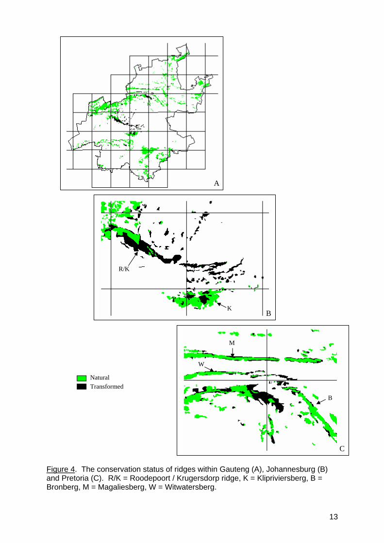
4. The conservation status of ridges in Gauteng The quartzite ridges of Gauteng are extremely limited in distribution. They are characterized by a unique plant species composition that is found nowhere else in South Africa or the world. As the Witwatersrand is considered to be transitional between the grassland and savanna biome, floristic elements from both these biomes contribute to the floristic richness of Gauteng ridges. Contributing to this richness is a third Drakensberg element in the flora. The Gauteng ridges, together with the Drakensberg Escarpment, should be regarded as one of the most important natural assets in the entire region of the northern provinces of South Africa (Bredenkamp & Brown, 1998). By 1994, eighty-three percent of ridges in Gauteng were still in an untransformed / natural state (Table 1, Figure 4). Urbanization represents the major threat to ridges, already having transformed 11% of the ridges by 1994. Encroaching alien vegetation, agriculture and mines/quarries are also responsible for the permanent transformation of ridge habitat in the province (Table 1). The situation does not appear to be so severe until the conservation status of ridges within the urban environment is taken into account. By 1994, only 38% of ridges in Johannesburg remained in a natural state, with 53% urbanized (Table 1). This is of considerable concern as the values of ridges described in section 3 become even more important within the urban environment. The Klipriviersberg is virtually the only ridge system left somewhat intact in Johannesburg (Figure 4). A highly sensitive habitat for at least two Gauteng plant endemics, one of which is only found predominantly on the Klipriviersberg, it is absolutely essential that all efforts are made to prevent any further transformation of this last remaining ridge in Johannesburg. Furthermore, any further transformation of the other ridges in Johannesburg should be prevented, since at least partial functioning of the ridges could then be retained. The ridges within Pretoria had not undergone such severe transformation by 1994 (Table 1, Figure 4). This is most likely due to the protection afforded to the Magaliesberg as a Protected Natural Environment. Urbanization of the Witwatersberg has not been that severe. The latter ridge was protected by the Greater Pretoria Guideplan as a “Nature Area” until 1995, after which the local authority continued this policy by preventing development of the ridge (Christa Grobler, Gauteng Directorate of Environment, pers. comm.). Nevertheless, 31% of the ridge environment in Pretoria had been urbanized by 1994. Currently major pressure exists to urbanize and develop the Bronberg, a trend that should be curtailed as soon as possible.
11

Table 1. The conservation status of ridges in Gauteng (GTN), Johannesburg (JHB) and Pretoria (PTA) determined using the CSIR/ARC national land cover data, which is based on 1994 1:250 000 LANDSAT imagery.
% OF RIDGES LAND COVER CLASS GTN JHB PTA
Untransformed / natural 83% 38% 62% Exotics / alien vegetation 2% 3% 5% Agriculture 2% 0% 1% Urban 11% 53% 31% Mines & quarries 2% 6% 1%
12
A
R/K
K B
W
M
B
C
Natural Transformed
Figure 4. The conservation status of ridges within Gauteng (A), Johannesburg (B) and Pretoria (C). R/K = Roodepoort / Krugersdorp ridge, K = Klipriviersberg, B = Bronberg, M = Magaliesberg, W = Witwatersberg.
13

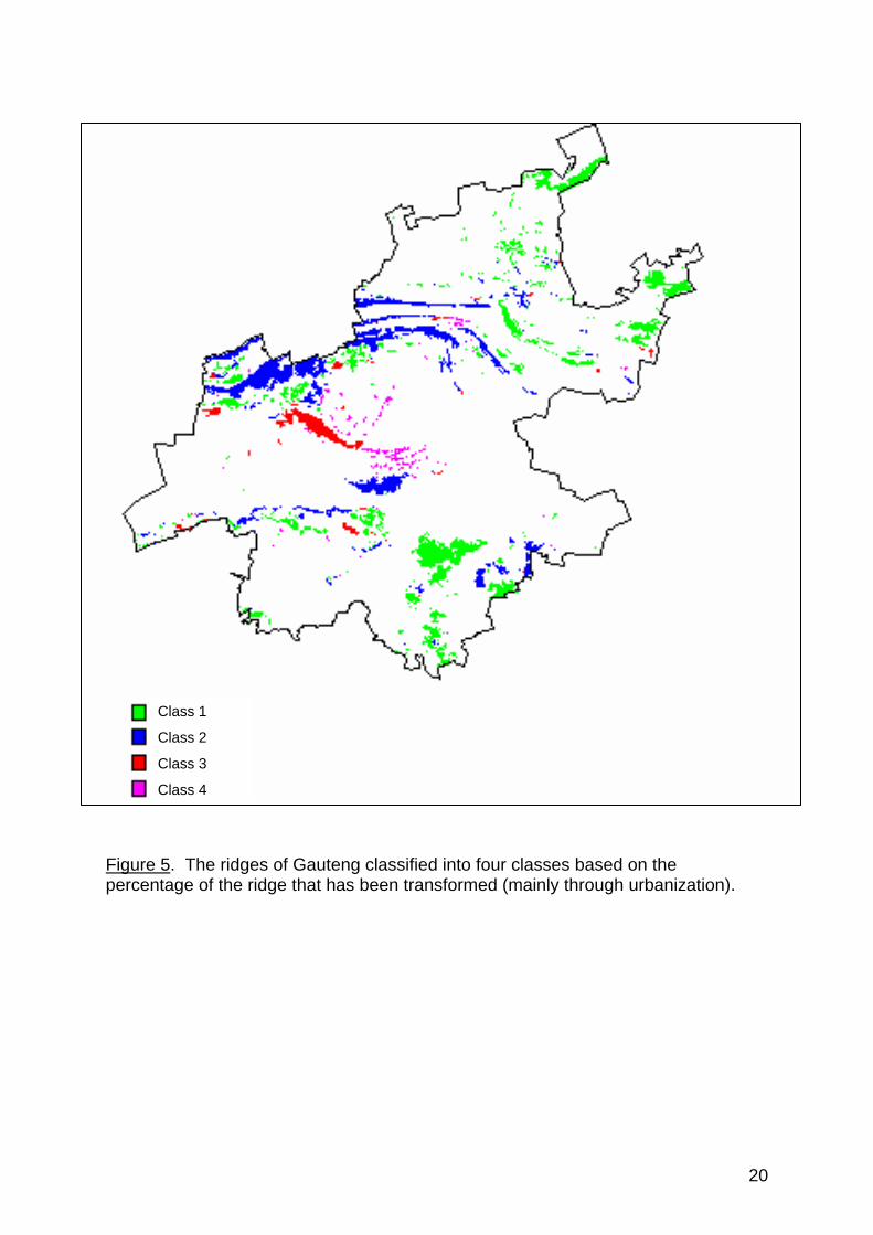
5. Departmental development policy for ridges in Gauteng In the light of the motivations presented in section 3 of this document and due to the extremely limited distribution, rarity and threatened status of the ridges in Gauteng, it is imperative that the Department adopts a strict no-go or low impact development policy for these systems. However, this policy, by necessity, will have to be adapted according to the current transformed status of some of these ridges. The policy guidelines outlined below are relevant to all ridges as defined in section 2 of this policy document and as spatially delineated in the GIS environmental management system of Environmental Assessment (Figure 5). All ridges in Gauteng have been classified into four classes (Figure 5) based on the percentage of the ridge that has been transformed (mainly through urbanization) using the 1994 CSIR/ARC Landcover data. This forms the basis of the development guidelines that are detailed in the table below. Please note that although rocky outcrops are not covered by the policy (since their small area coverage does not allow the classification of these features as ridges) they are regarded as sensitive areas characterized by high biodiversity and as such a no-go development policy should be applied. Implementation of this guideline is specifically needed at the local council level during the passing of building plans.
14

Ridge type % of
Gau-teng ridges
Policy
Class 1 (0-5% transformed) includes Suikerbosrand & parts of Magaliesberg
47% No further development allowed (including residential). Strict no-go policy. No further subdivisions will be allowed and consolidation of subdivisions will be encouraged. If developer should wish government to deviate from strict no-go policy, a full EIA (including public participation exercise) is required with full set of specialist reports including (but not limited to): • An ecological study, including both functional (ecological processes
including connectivity function of ridge at a landscape level perspective) and compositional (biodiversity) aspects
• A Red Data study for both fauna and flora • An invertebrate study • A hydrological / geohydrological study • A geotechnical study • A pollution study, including both air and water pollution • A social study, including cultural, historical and open space value
aspects • A visual study • A study of service provision and access All specialist studies to examine cumulative impacts. A 200m buffer zone¹ of low impact development is required around class 1 ridges. Development proposals within the buffer zone should proceed at least to the mini EIA stage.
Current Future
Undeveloped/untransformed Developed/transformed
15

Class 2 (5-35% transformed) includes parts of Magaliesberg, World Heritage site, Klipriviersberg, Bronberg, Skurweberg
40% No further subdivisions will be allowed and consolidation of subdivisions will be encouraged. No-go development policy; low impact (e.g. tourism developments) will be considered requiring full EIA (including public participation exercise) with full set of specialist reports including (but not limited to): • An ecological study, including both functional (ecological processes
including connectivity function of ridge at a landscape level perspective) and compositional (biodiversity) aspects
• A Red Data study for both fauna and flora • An invertebrate study • A hydrological / geohydrological study • A geotechnical study • A pollution study, including both air and water pollution • A social study, including cultural, historical and open space value
aspects • A visual study • A study of service provision and access All specialist studies to examine cumulative impacts. Ecological footprint² of low impact developments to cover no more than 5% of a property. All impacts for these developments must be sufficiently mitigated. A management plan to maintain the ecological integrity of remaining property is required and implementation is the responsibility of the developer. A 200m buffer zone¹ of low impact development is required around class 2 ridges. Development proposals within the buffer zone should proceed at least to the mini EIA stage. DACEL undertakes to conduct Strategic Environmental Assessments for these ridge systems.
Current Future
Undeveloped/untransformed Developed/transformed
16

Class 3 (35-65% transformed) includes Northcliff/ Roodepoort/ Krugersdorp ridge
8% Ridges in this class are to be designated as low impact development areas (A) and high impact development areas (B). DACEL will consider an entire ridge in this class under A until such time as the local council conducts and submits for approval a Strategic Environmental Assessment that designates B areas. Development to be contained within areas that are already transformed. (A) No further subdivisions will be allowed and consolidation of subdivisions will be encouraged. Low impact (e.g. tourism developments) will be considered requiring full EIA (including public participation exercise) with full set of specialist reports including (but not limited to): • An ecological study, including both functional (ecological processes
including connectivity function of ridge at a landscape level perspective) and compositional (biodiversity) aspects
• A Red Data study for both fauna and flora • An invertebrate study • A hydrological / geohydrological study • A geotechnical study • A pollution study, including both air and water pollution • A social study, including cultural, historical and open space value
aspects • A visual study • A study of service provision and access All specialist studies to examine cumulative impacts. Ecological footprint² of low impact developments to cover no more than 5% of a property. All impacts for these developments must be sufficiently mitigated. A management plan to maintain the ecological integrity of remaining property is required and implementation is the responsibility of the developer. A 200m buffer zone¹ of low impact development is required around class 3(A) ridges. Development proposals within the buffer zone should proceed at least to the mini EIA stage. (B) Exempt from EIA process unless: (1) A Red Data species is recorded for the ridge – implementation of
Red Data policy is required. (2) The open space³ is 4ha* or larger. EIA with all specialist reports
(see A above) required. All policy guidelines as listed for A above are applicable.
(3) Surrounding community / landowners object. A scoping report is then required with specialist reports identified in accordance with public objections but should at least include a social study, including cultural, historical and open space value aspects
Current Future
Undeveloped/untransformed Developed/transformed
B A B A
17
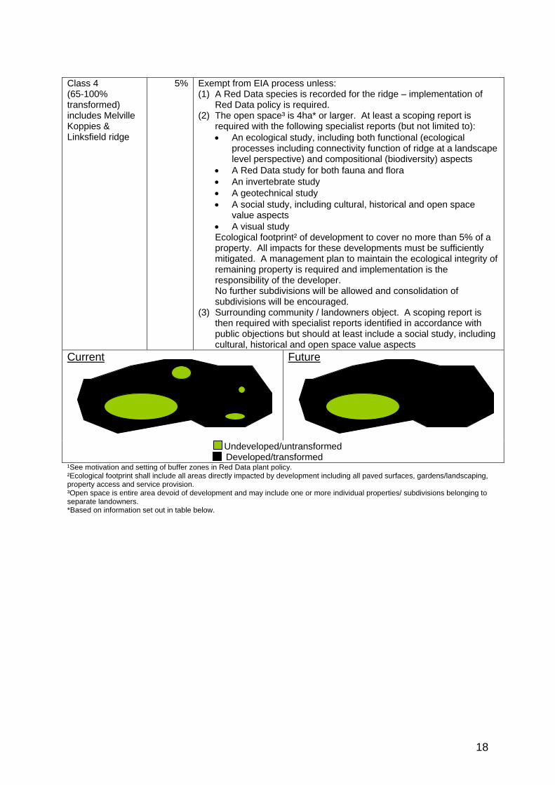
Class 4 (65-100% transformed) includes Melville Koppies & Linksfield ridge
5% Exempt from EIA process unless: (1) A Red Data species is recorded for the ridge – implementation of
Red Data policy is required. (2) The open space³ is 4ha* or larger. At least a scoping report is
required with the following specialist reports (but not limited to): • An ecological study, including both functional (ecological
processes including connectivity function of ridge at a landscape level perspective) and compositional (biodiversity) aspects
• A Red Data study for both fauna and flora • An invertebrate study • A geotechnical study • A social study, including cultural, historical and open space
value aspects • A visual study Ecological footprint² of development to cover no more than 5% of a property. All impacts for these developments must be sufficiently mitigated. A management plan to maintain the ecological integrity of remaining property is required and implementation is the responsibility of the developer. No further subdivisions will be allowed and consolidation of subdivisions will be encouraged.
(3) Surrounding community / landowners object. A scoping report is then required with specialist reports identified in accordance with public objections but should at least include a social study, including cultural, historical and open space value aspects
Current Future
Undeveloped/untransformed Developed/transformed ¹See motivation and setting of buffer zones in Red Data plant policy. ²Ecological footprint shall include all areas directly impacted by development including all paved surfaces, gardens/landscaping, property access and service provision. ³Open space is entire area devoid of development and may include one or more individual properties/ subdivisions belonging to separate landowners. *Based on information set out in table below.
18
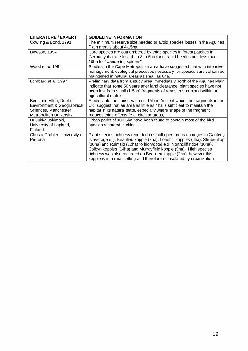
LITERATURE / EXPERT GUIDELINE INFORMATION Cowling & Bond, 1991 The minimum reserve size needed to avoid species losses in the Agulhas
Plain area is about 4-15ha. Dawson, 1994 Core species are outnumbered by edge species in forest patches in
Germany that are less than 2 to 5ha for carabid beetles and less than 10ha for “wandering spiders”
Wood et al. 1994 Studies in the Cape Metropolitan area have suggested that with intensive management, ecological processes necessary for species survival can be maintained in natural areas as small as 6ha.
Lombard et al. 1997 Preliminary data from a study area immediately north of the Agulhas Plain indicate that some 50 years after land clearance, plant species have not been lost from small (1-5ha) fragments of renoster shrubland within an agricultural matrix.
Benjamin Allen, Dept of Environment & Geographical Sciences, Manchester Metropolitan University
Studies into the conservation of Urban Ancient woodland fragments in the UK, suggest that an area as little as 4ha is sufficient to maintain the habitat in its natural state, especially where shape of the fragment reduces edge effects (e.g. circular areas).
Dr Jukka Jokimäki, University of Lapland, Finland
Urban parks of 10-35ha have been found to contain most of the bird species recorded in cities.
Christa Grobler, University of Pretoria
Plant species richness recorded in small open areas on ridges in Gauteng is average e.g. Beaulieu koppie (2ha), Lonehill koppies (6ha), Strubenkop (10ha) and Ruimsig (12ha) to high/good e.g. Northcliff ridge (10ha), Colbyn koppies (14ha) and Murrayfield koppie (9ha). High species richness was also recorded on Beaulieu koppie (2ha), however this koppie is in a rural setting and therefore not isolated by urbanization.
19
Class 1
Class 2
Class 3
Class 4
Figure 5. The ridges of Gauteng classified into four classes based on the percentage of the ridge that has been transformed (mainly through urbanization).
20

6. References Adams & Dove, (1989). Wildlife reserves and corridors in the urban environment. A guide to ecological landscape planning and resource conservation. National Institue for Urban Wildlife, U.S.A. Armstrong A.J & Van Hensbergen H.J. (1996). Small mammals in afforestable montane grasslands of the northern Eastern Cape Province, South Africa. South African Journal of Wildlife Research, 26, 11-17. Barnes, K.N. (2000). The Eskom Red Data Book of Birds of South Africa, Lesotho and Swaziland. Birdlife South Africa, Randburg. Branch, B. (1992). Bill Branch’s field guide to the snakes and other reptiles of southern Africa. Struik Publishers, Cape Town. Bredenkamp, G.J. & Brown, L.R. (1998). A vegetation assessment of open spaces in the Western Metropolitan Local Council Area. A report commissioned by the Western Metropolitan Local Council. Broadley, D.G. (1990). Fitzsimon’s snakes of southern Africa. Jonathan Ball & A.D. Donker Publishers. Burnett, M.R., August, P.V., Brown, J.H. & Killingbeck, K.T. (1998). The influence of geomorphological heterogeneity on biodiversity. I. A patch-scale perspective. Conservation Biology, 12, 363-370. Cook, C. (2000). Unpublished report on the current conservation status of amphibian species in the Gauteng province. Cowling, R.M. & Bond, W.J. (1991). How small can reserves be? An emperical approach in Cape fynbos, South Africa. Biological Conservation, 58, 243-256. Eber, S. (2000). A comparative study of land cover change in the Magaliesberg mountain area, Gauteng. South Africa. Doctoral thesis. In progress. Ginn, P.J., McIlleron, W.G. & Milstein, P. le S. (1989). The complete book of southern African birds. Struik, Cape Town. Grobler, 2000. From MSc. investigation of plant communities associated with urban open spaces in Gauteng. University of Pretoria. Hilton-Taylor, C. (1996). Red Data List of Southern African Plants. Strelitzia 4. National Botanical Institute, Pretoria. Jacobsen, N.H.G. (1988). Proposal for the deregulation of the reptiles and amphibians of Gauteng province. Kearns, C.A., Inouye, D.W. & Waser, N.M. (1998). Endangered mutualisms: The conservation of plant-pollinator interactions. Annu. Rev. Ecol. Syst. 29, 83-112.
21

Lombard, A.T., Cowling, R.M., Pressey, R.L. & Mustart, P.J. (1997). Reserve selection in a species-rich and fragmented landscape on the Agulhas Plain, South Africa. Conservation Biology, 11, 1101-1116. Loney, B. & Hobbs, R.J. (1991). Management of vegetation corridors: maintenance, rehabilitation and establishment. In Nature Conservation 2: The role of corridors. Saunders, D.A. & Hobbs, R.J. (eds). Pages 299-311. Surrey Beatty & Sons Pty Limited, Australia. Lowrey, T.K. & Wright, S. (1987). The Flora of the Witwatersrand. Volume I: The Monocotyledonae. Witwatersrand University Press, Johannesburg. Maclean, G.L. (1993). Roberts Bird Book of southern Africa. 6th Edition. The Trustees of the John Voelcker Bird Book Fund, Cape Town. Pfab, M.F. (2000). Draft Red Data plant policy. Directorate of Nature Conservation. Poynton, J.C. & Roberts, D.C. (1985). Urban open space planning in S.A.: A biogeographical perspective. South African Journal of Science, 81, 33-37. Primack, R.B. (1995). A Primer of Conservation Biology. Sinauer Associates, U.S.A. 277 pages. Rosenberg, D.K., Noon, B.R. & Meslow, E.C. (1997). Biological Corridors: Form, Function and Efficacy. Bioscience, 47, 677-687. Rutherford, M.C., Midgley, G.F., Bond, W.J., Powrie, L.W. & Rebelo, A.G. (2001). Vulnerability of the plant diversity of South Africa to projected climate change. Paper presented at the 27th annual conference of the South African Association of Botanists. Samways, M.J. (1994). Insect Conservation Biology. Chapman & Hall. Samways, M. & Hatton, M. (2000). Palmnut Post, Vol 3, No 2, 9-11. Tarboton, W.R. (1997). The status and conservation importance of birds in Gauteng province. van Rooy, J. (2000). Introduction to bryology in southern Africa. 8. Moss diversity and endemism. PlantLife, 23, 31-32. Williams, M. (1994). Butterflies of southern Africa. A field guide. Southern Book Publishers.
22