guide tourist-cinematographic route filabres-alhamilla · “el sabor de la venganza”(1963) or...
TRANSCRIPT
Tourist-Cinematographic RouteFilabres-Alhamilla
Guide
Una Comarca
de cine...
SCENE TAKE

In memory of the movie world in Almeria as a prime cultural legacy and a present and future tourist asset.
To all the tourists and visitors who want to enjoy a region full of light, colours and originality.
Tourist-Cinematographic RouteFilabres-Alhamilla
Guide

Promoted and edited by Commonwealth of Municipalities for the Development of Interior Towns
Idea and general coordination José Castaño Aliaga, manager of the Tourist Plan of Filabres-AlhamillaMalcamino’s
Route design, texts, documentation, tourist information, stills selection, locations, docu-mentary consultancy, Road Book creation, maps and GPS coordinates. Malcamino’s
Creative directionwww.oncepto.com
Design and layoutSonja Gutiérrez
Front-page picture Sonja Gutiérrez
PrintingArtes Gráficas M·3
Legal deposit XXXXXXX
TranslationItraductores
AcknowledgementTo all the municipalities integrated in the Commonwealth of Municipalities for the De-velopment of Interior Towns: Alcudia de Monteagud, Benitagla, Benizalón, Castro de Fi-labres, Lucainena de las Torres, Senés, Tabernas, Tahal, Uleila del Campo and Velefique
Documentation and publications for support and/or interestAlmería, Plató de Cine – Rodajes Cinematográficos (1951-2008) – José Márquez Ubeda (Diputación Provincial de Almería)Almería, Un Mundo de Película – José Enrique Martínez Moya (Diputación Provincial de Almería)Il Vicino West – Carlo Gaberscek (Ribis)Western a la Europea, un plato que se sirve frio – Anselmo Nuñez Marqués (Entrelíneas Editores)La Enciclopedia de La Voz de AlmeríaFuentes propias de Malcamino’s
Reference and/or interest Webs www.mancomunidadpueblosdelinterior.eswww.juntadeandalucia.es/turismocomercioydeportewww.almeriaencorto.eswww.dipalme.orgwww.paisajesdecine.comwww.almeriaclips.comwww.tabernasdecine.eswww.almeriacine.es
Photo: Sonja Gutiérrez

index
9
1011
142223252728323334364246
5054565860
6264
6872
Prologue “Land of movies for ever and ever... Almeria”
Filabres-Alhamilla Region (drop-down map) Route recommendations
ROUTE 1 Tabernas-Polopos Main RouteTabernasCastro de FilabresVelefiqueSenésTahalAlcudia de MonteagudBenitaglaBenizalónUleila del CampoLucainena de las TorresPoloposPuntal de Polopos
ROUTE 2 Arterial Tabernas RouteTabernas CastleRambla Roja or Rambla de la Sierra Tortuga or Rambla del Búho Valle del Búho Viewpoint Cerro Castillejo or Cabeza de Águila
ROUTE 3 Arterial Black Canyon RouteTabernas Main SquareBlack Canyon or Rambla del Saltador
StillsMovies filmed in the Filabres-Alhamilla Region

Land of movies forever and ever…
AlmeriaAlmeria has been converted, with the passing of hun-dreds of shootings, into landscapes of Africa, the Uni-ted States, Jordan, Mexico, Afghanistan or Australia in mythical shootings such as “Lawrence de Arabia”, “Rey de Reyes”, “Patton” or recent films like “Camino”, “Los Límites del Control” or “Millenium”, among others.
We are now in 1956. With “Ojo por Ojo”, the Tabernas Desert, one of the most appreciated landscapes of the province, jumped into stardom. With the French direc-tor André Cayatte, the eroded hillsides of the desert of
Almeria were released in all their beauty and dramatic quality all over the world. From that moment, the shootings followed one another...
The natural park of Cabo de Gata-Níjar, the towns of the Sierra de Filabres, Gádor or Alhamilla, the landscapes of Poniente and the only desert of Europe have been exceptional landscapes for leading shootings.
In 1964 the “Dollars Trilogy”, with a young Sergio Leone, was the detonator of Al-meria as a clear worldwide Land of Movies both for “spaghetti western” and for all the other genres that were looking for a backdrop in this land for their love stories, pursuits, revenges, dramas and adventures.
Up to now (2011), more than 500 feature films have been registered in the province of Almeria, 273* of which have located and developed part of their scenes in the Filabres-Alhamilla region, where the variety of landscapes goes from the Tabernas Desert to the heights of Sierra de Alhamilla or the typical towns of Sierra de Filabres.
Sergio Leone, Sergio Corbucci, Orson Welles, David Lean, Mario Caiano, Steven Spie-lberg, Alex de la Iglesia... Clint Eastwood, Claudia Cardinale, Brigitte Bardot, Peter O’Toole, Richard Burton, Henry Fonda, Terence Hill, Bud Spencer, Louis de Funés, Alain Delon, Carmen Maura, Sancho Gracia... and a great many of big names of the world cinematographic legacy that we will remember all though this route.
From the Commonwealth of Municipalities, we invite you to visit the places visited by your favourite heroes and to enjoy the authentic taste of the towns and landsca-pes that still are a “movie set”.
* Information extracted from the publications available to date. Maybe that, due the great amount of shootings, not all of them are documented and there could be more.
9

CicloturismoCycle-routes
SenderismoHiking trails
Rutas a caballoHorse-riding trails
Rutas con dromedariosDromedary tours
Rutas guiadas en todoterrenoGuided 4x4 trips
Comida típicaRegional cuisine
ArtesaníaLocal crafts
Observatorio AstronómicoObservatory
CastilloMedieval castle
Restos minerosMining towers
Productos lácteos
Dairy products
AlmazaraOil press
Vista panorámicaPanoramic view
Please unfold the right page to see the map of the region and the routes with infor-mation of interest for your visit.
Comarca
Filabres-AlhamillaThe Tourist-Cinematographic Route of the Filabres-Alhamilla region lays on a general su-ggested trip starting in Tabernas and finishing in Lucainena de Las Torres.
The route has been designed to follow it by car, as all the places mentioned are easily ac-cessible in a small car.
From the general route, there are two optio-nal transversal routes:
Arterial Tabernas Route:This is a mixed route. This route goes deeper into a surrounding watercourse of the town of Tabernas and we must respect the neighbouring natural environment; therefore we suggest making this route on foot or by bicycle. Part of the journey is accessible by car.
Cañón Negro Route:This is a small return route through a well-known watercourse in the movie world. The path is not asphalted and we advise to make it on foot or by bicycle, leaving the car at the beginning of the road.
To enjoy the routes, we recommend:
All through the route:There are interpretation signs in every point of interest, such as within the city cen-tre, viewpoints or natural areas. They are easily recognizable, as they are indicated in the guide with this logotype:
The generic map and the guide diagrams can guide you or you can look up the maps included in some of the interpretation signs.
The route has been designed on the basis of a series of GPS reference data and a series of sketches that form the “Road Book” and indicate in every moment the direction to follow.
Besides the signs, in this guide you will find references to information and anecdotes of tourist-cinematographic interest, supported by images.
1110
Tourist-Cinematographic Route Filabres-AlhamillaGuide

On the road:The route has been indicating with road signposting that will guide you together with the indications of this guide. Whenever you want to stop to watch and enjoy the landscapes in your way, please park your car properly without slowing the traffic down or holding up the passing of other vehicles on the road.
When you are in nature:
· Please observe the signs marked. · Private areas are NOT accessible to the public. They all are duly signed. It is impor-tant to follow the indications of the guide and/or the existing signs.
Respect the environment:
Please do not forget that part of the route runs through unique and fragile natural areas: · Do not leave or bury garbage, not even organic waste. Take bags to collect it and throw it away in the appropriate bins. · Please do not light a fire. · Please keep off the local flora and the slopes to prevent soil damages.· Respect the paths and the tracks of the marked routes. · Please avoid vehicles in non-asphalted areas. It is better for the environment to travel across those stretches on foot or by bicycle. · Please do not break the silence of the natural environment whenever you cross areas where the presence of fauna is clear (even if it is not visible). · You can find cattle or free animals (rabbits...). If you have a dog, please tie it up. · Please do not pull flowers or branches up or tale stones from the slopes. · Camping is forbidden in unauthorized areas.
NOTE:To make the guided routes in the nature, please contact active tourism companies and authorized tourist centres, that will provide you with a wide range of activities such as four-by-four vehicles, hiking, horse riding, dromedary riding, etc. through the natural spots of the region, authorized routes controlled by the Department of Tourism and Environment designed to minimize the negative impact on the environment.
ROUTE 1
Tabernas-Polopos Main Route / 155 Km+-
ROUTE 2
Tabernas Arterial Route / 13 Km+-
ROUTE 3
Black Canyon Arterial Route / 12 Km+-
12
Tourist-Cinematographic Route Filabres-AlhamillaGuide

ROUTE 1: Main route between Tabernas and Polopos
Tabernas In the 50s, the world impact of the movie industry gave rise to the birth of “location scouts”, persons whose work consisted in looking for places all over the world whose aesthetic characteristics and faci-lities made the development of audiovisual works more favourable. The success of the French direc-tor André Cayatte with the film “Oeil pour Oeil” (1956), partly shot in the landscapes of the Taber-nas Desert, led to the recognition of these spots as movie locations. The rest of the province also be-came a movie scene in films such as “Les Bijoutiers du Clair de Lune” (1956), “Duelo en la Cañada” (1959) and “La India en Llamas” (1959). These were the years of renowned movies such as “Rey de Re-yes”(1961), “Tierra Brutal”(1961), “Goliat contra los Gigantes”(1962),“Lawrence de Arabia”(1962), “Cleopatra”(1963) and others.
The European Western made its entrance in the market with renowned titles like “El Sabor de la Venganza”(1963) or “Antes Llega la Muerte”(1964) by the prolific and well-known director of Almeria, J.L. Romero Marchent , who said: “In Almeria we first found out the possibility that movies looked like real American western”.The landscapes of the region were required and mobile sets were built, using the existing service logistics and industry of Madrid and other capital cities.
1964: Detonation of the so-called Spaghetti Western with the Dollars Trilogy.
“Por Un Puñado de Dólares” opened the trilogy starring the character of the “Man-co” (the one-armed man), played by Clint Eastwood. With this first film, Sergio Leo-ne laid down the grounds of a new entertaining genre that revolutionized the cinematographic world.Then he only required the night landscapes of the watercourses to recreate a pursuit. Next year they shot “La Muerte Tenía un Precio” (1965). For this second movie, producer Alfredo Fraile opted for building the first far-west village, called “the vi-llage of the Fraile” (in honour of its promoter) or “Mini- Hollywood”. These sets were also used in the shooting of “El Bueno, el Feo y el Malo” (1966) and a great many of titles such as “Joe el Impla-cable” (1966), “Doc” (1971), “Los Hijos del Día y de la Noche”(1972), “Los Locos del Oro Negro” (1975), “Dos Granujas en el Oeste” (1981), “Al Este del Oeste” (1984) or “La Luz de la Primera Estrella” (2004).
Mini Hollywood village in “The Good, the Bad and the Ugly” (1966)
The detonation of the Spaghetti Western gave rise to an unprecedented fame, tur-ning the province into a real movie set, where the Filabres-Alhamilla region gained a relevant prominence.
“For a Few Dollars More” (1964) Night riding through the desert
TABERNASMain Square. SIGN. Start of the movie route Follow towardsCastro de Filabres. TOTAL Km.: 0PARTIAL Km.: 0 M. HEIGHT: 384WP/UTM: 30S 554560 mE 4101582 mN
1514
Gloria Milland in “Gunfight at Highnoon” (1963)
Tourist-Cinematographic Route Filabres-AlhamillaGuide

1965-1966: Construction of the village known as Paco Ardura, Texas Hollywood or Fort Bravo.
Today considered by many professionals as one of the few or maybe the only outdoors set within these characteristics in the Spanish territory. It seems that this village was built with the idea of providing an alternative set for “El Bueno, el Feo y el Malo”, although they finally used Mini Hollywood for the shooting. With that being said, Fort Bravo was the setting for hundreds renowned shootings, such as “El Cóndor”(1970), “Que Viene Valdez” (1970), “Catlow”(1971), Blindman (1971), “Chato” (1971) or “El Zorro” (1990), among others and, recently, “800 Balas”(2002), “Blueberry”(2004) or “Los Dalton contra Lucky Luke”(2005)... This is the only village with an original period Mexican area.
Mexican village in “Los Dalton contra Lucky Luke” (2004)Stills and cover “The Good, the Bad and the Ugly” (1966)
Stills and cover of “For a Few Dollars More” (1965)
Fort Bravo village in “Chato’s Land” (1971)
1716
Tourist-Cinematographic Route Filabres-AlhamillaGuide
1968: Western Leone was built for the shooting of “Hasta que Llegó su Hora”, directed and produced by the Italian master, who started his activity with his own production company, RAFRAN Cinematografica. The ranch constructed for the movie still stands nowadays, but the one-kilometre long railway line built for the spectacular final sce-ne of the movie has disappeared. After this movie, it was used for logistic support and as a set in “Chato”(1971), “Una Razón para Vivir, Otra para Morir” (1972), “Los Cuatro del Apocalipsis” (1975), “Estos Locos Cuatreros” (1985), etc.
“Once Upon a Time in the West” (1968)
“Conan the Barbarian” (1981)
“Besides its impres-sive landscape, Tabernas offers its urban environment with the participation of its inhabitants”
Besides these three villages, that still remain, tens of sets were built, raised, pulled down and rede-signed according to the needs of every shooting. The truth is that you can still find remains of tho-se construction walking through the desert, transformed into “re-lics” and pursued by the so-called “movie archaeologists”. We can mention, as an example, the village of Tecisa (Nueva Frontera) or the Cóndor, redesigned for the movie “Conan El Bárbaro” (1981), both of them used in several films.
INDICATIONS TO FOLLOW THE ROUTE: From the main square, go towards the exit of the town (northern area) up to the service area “LAS ERAS”, just to the left. Both the restaurant and the petrol station were the background sets of the scenes of a German series, entitled “Auf Achse” (1990). The inhabitants of the town par-ticipated in the scenes shot here as extras as well as a local company of international transport. After this shooting it was used as a set in TV audiovisual works.
This was the beginning of hundreds of “Spaghetti” movies, meeting point of great producers and directors, of incessant visits of the most famous figures of this time.... And also the shooting set of films of different genres.
In these pages you will sometimes find the circle “Point with sign*” and the logotype of the routes (the clapperboard), indicating the places where there is a sign with information about what happened there.
Tabernas became the meeting point of the movie world of this time, offering, besides the impressive natural lands-
capes of the desert, its urban atmosphere, including its inhabitants, who participated actively in the shooting of scenes in movies like “Orgullo de Estirpe”(1970) or “Agá-
chate Maldito” (1970), just to name a few. We would like to highlight the shooting of one scene in the main square in
the fantastic movie “El Valle de Gwangi”(1968), which brought together hundreds of extras and an uncommon parade of animals.*Main square
Sign point*
Arnold Schwarzenegger in “Conan the Barbarian”
Still of “The Valley of Gwangi”
Junction. Follow towards theN-340A roundabout.TOTAL Km.: 1,050PARTIAL Km.: 0,100M. HEIGHT: 438WP/UTM: 30S 554605 mE4101648 mN
Est.
Servicio
Las Eras Service Station and Restaurant.TOTAL Km.: 0,950PARTIAL Km.: 0,950M. HEIGHT: 438
Est.
Servicio
General view of Tabernas in “Tepepa” (1970)
1918
Tourist-Cinematographic Route Filabres-AlhamillaGuide

1 · Still of “Auf Achse” (1990). Las Eras petrol station2 · Leading actors of “ Auf Achse”3 · Inside Las Eras restaurant
Suggestions
Visit to the standing villages, which offer different alternatives (see situa-tion in the general map):
· Oasys theme-park (Mini-Hollywood) · Sets of Cine Fort Bravo · Western Leone village
In the town, snack bars as well as menu and/or à la carte restaurants with traditional local recipes.
Visit to the church and climb to the Tabernas castle, starting point of the arterial route of Tabernas to follow with the movie theme (page 50).
Visit to the Interpretation Centre of Terreta Ventura and the Tabernas De-sert for a better understanding of the formation of this particular landscape, as well as the habits of a prehistoric town that settled here.
Following the route book you can reach Castro de Filabres and then Velefique.
Slate deposit in the landscape of the region
Castro de Filabres-Velefique junction. Follow towardsCastro de Filabres.TOTAL Km.: 2,580PARTIAL Km.: 1,080M. HEIGHT: 467WP/UTM: 30S 554797 mE4103135 mN
Castro de Filabres-Velefique junction. Follow towardsCastro de Filabres.TOTAL Km.: 12,200PARTIAL Km.: 9,620M. HEIGHT: 690WP/UTM: 30S 551329 mE4111342 mN
Tabernas N-340A rounda-bout. Follow towards Castro de Filabres.TOTAL Km.: 1,500PARTIAL Km.: 0,50M. HEIGHT: 440WP/UTM: 30S 554607 mE 4102102 mN
Tabernas N-340A rounda-bout. Follow towards Castro de Filabres.TOTAL Km.: 1,450PARTIAL Km.: 0,400M. HEIGHT: 440WP/UTM: 30S 554628 mE 4102065 mN
2120
Tourist-Cinematographic Route Filabres-AlhamillaGuide
Velefique Castro de Filabres
Castro de Filabres-Velefique junction. Follow towards Velefique.TOTAL Km.: 23,600PARTIAL Km.: 5,700M. HEIGHT: 690WP/UTM: 30S 551317 mE4111351 mN
VelefiqueTo continue, return to the Km. 2,580 and follow towards SenésTOTAL Km.: 29,900PARTIAL Km.: 6,300M. HEIGHT: 908WP/UTM: 30S 552999 mE 4116555 mN
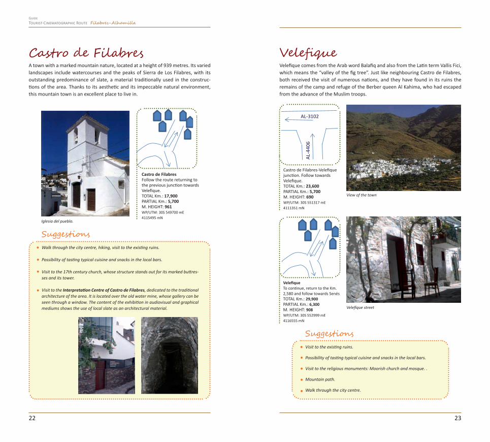
A town with a marked mountain nature, located at a height of 939 metres. Its varied landscapes include watercourses and the peaks of Sierra de Los Filabres, with its outstanding predominance of slate, a material traditionally used in the construc-tions of the area. Thanks to its aesthetic and its impeccable natural environment, this mountain town is an excellent place to live in.
Velefique comes from the Arab word Balafiq and also from the Latin term Vallis Fici, which means the “valley of the fig tree”. Just like neighbouring Castro de Filabres, both received the visit of numerous nations, and they have found in its ruins the remains of the camp and refuge of the Berber queen Al Kahima, who had escaped from the advance of the Muslim troops.
SuggestionsVisit to the existing ruins.
Possibility of tasting typical cuisine and snacks in the local bars.
Visit to the religious monuments: Moorish church and mosque. .
Mountain path.
Walk through the city centre.
Suggestions Walk through the city centre, hiking, visit to the existing ruins.
Possibility of tasting typical cuisine and snacks in the local bars.
Visit to the 17th century church, whose structure stands out for its marked buttres-ses and its tower.
Visit to the Interpretation Centre of Castro de Filabres, dedicated to the traditional architecture of the area. It is located over the old water mine, whose gallery can be seen through a window. The content of the exhibition in audiovisual and graphical mediums shows the use of local slate as an architectural material.
Iglesia del pueblo.
Castro de FilabresFollow the route returning to the previous junction towards Velefique.TOTAL Km.: 17,900PARTIAL Km.: 5,700M. HEIGHT: 961WP/UTM: 30S 549700 mE4115495 mN
View of the town
Velefique street
2322
AL-4
406
AL-3102
Tourist-Cinematographic Route Filabres-AlhamillaGuide

After the visit to Castro de Filabres and Velefique, we will take the road again up to the first crossroad to go off course towards Senés.On the way, we will pass in front of the entrance to the CAÑON NEGRO, another arterial route proposed by this guide (page 62).
SenésJust like the two previous towns, Senés stands out for the
impressive landscapes that surround it, black “coloured” by the slate material. This village has some outstanding po-pular masonry constructions finished with such material and a very special aesthetic, adapted to the rough orogra-
phy of the land.Besides some general shots used for certain scenes, Senés
was chosen to be the “set” by the cult director Jim Jarmush in his recent movie “Los Límites del Control”.
The shooting was held during two days, using both the Bar “El Mirador” and the adjacent streets. Some of the extras were inhabitants of the town. *Access Plaza to the bar “El Mirador”
Sign point*
Junction. Follow towards Senés.TOTAL Km.: 45,800PARTIAL Km.: 15,900M. HEIGHT: 467WP/UTM: 30S 554785 mE 4103142 mN
Rambla del Saltadoror Cañón NegroFollow towards Senés.TOTAL Km.: 51,600PARTIAL Km.: 5,800M. HEIGHT: 568WP/UTM: 30S 557745 mE4108157 mN
“The Horsemen” (1970)
We can highlight two stills from the film “Orgullo de Estirpe”, an American produc-tion by director John Frankenheimer, starring Omar Sharif, Leigh Taylor Young and Jack Palance among others using the landscape of the area to create the setting.
The blackish landscape and the lumberyards made of slate material from the moun-tain range adjoining the towns of Castro and Velefique served as the scenario for some of the story scenes.
“The Limits of Control” (2009)
Junction. Follow towards Senés.TOTAL Km.: 55,650PARTIAL Km.: 4,050M. HEIGHT: 632WP/UTM: 30S 559533 mE 4111609 mN
Senés. Sign.Continue the route towards Tahal.TOTAL Km.: 63,000PARTIAL Km.: 7,350M. HEIGHT: 980WP/UTM: 30S 558439 mE 4117722 mN
2524
A-349
A-34
9
Tourist-Cinematographic Route Filabres-AlhamillaGuide

Suggestions
Visit to the existing ruins.
Snacks and typical cuisine.
Visit to the religious monuments and walking through the streets.
Hiking.
Following the route guide you will cross part of the region reaching the town of Tahal, located in the crest of Collado García, a union pass between the Filabres- Al-hamilla region and the valley of Almanzora.
Junction.Follow towards Tahal.TOTAL Km.: 70,300PARTIAL Km.: 7,300M. HEIGHT: 1.134WP/UTM: 30S 562964 mE4117121 mN
Junction.Follow towards Tahal.TOTAL Km.: 76,100PARTIAL Km.: 5,800M. HEIGHT: 1.082WP/UTM: 30S 562618 mE 4120401 mN
restaurante
Suggestions
Visit to the existing ruins.
Good cuisine in bars and restaurants.
Visit to the church and walk through the streets.
Hiking around the city centre.
Visit to the Interpretation Centre of Tower of Tahal:
Tower of TahalDated from the 14th century, the tower has been recently restored and they have set up an Interpretation Centre inside about the fortifica-tions existing in the Filabres-Alhamilla region. A walk through the most recent his-tory of the region spreading
the different cultures settled in these sites throughout the years.
“The Limits of Control” (2009)
Tahal
oficina de
turismo
TahalContinue the route towards Alcudia de Monteagud.TOTAL Km.: 76,900PARTIAL Km.: 0,800M. HEIGHT: 1.033WP/UTM: 30S 563257 mE 4120659 mN
Tahal is an old domain and a traditional ranching town. Its castle and fortress deser-ves a visit before continuing the movie route.
2726
Tourist-Cinematographic Route Filabres-AlhamillaGuide

Short movie “La Hégira” (2010). Photography: Juanfran Martínez
After the visit to Tahal, following the belt road of the town, you reach Alcudia de Monteagud:
Alcudia de Monteagud
The threshing floor
This is the biggest one in the province, from where you can make out an excep-tional panorama over the Tahal valley. Its diameter is 40 m wide and it was constructed in 1894.
Besides the use it was constructed for, threshing cereals, it was the usual mee-ting place of the inhabitants of the region to share news about the outside world.
Representation of the threshing
The large THRESHING FLOOR is on the right as you reach the town. Leaving the threshing floor to the right, you must go down the street to the side of the church. From
there, go around the church and continue down the streets up to a second threshing floor. To the right of the se-
cond threshing floor, follow a poplar grove up to the entrance of an uphill narrow street that goes up to the exact point where the set of the North African town was assembled in “La Hégira”.
Sign point*
Suggestions
Visit to the existing ruins.
Good cuisine in the different local premises.
Visit to the church and walk through the streets.
Hiking around the city centre.
Junction. Follow towards Alcudia de Monteagud.TOTAL Km.: 77,100PARTIAL Km.: 0,200M. HEIGHT: 1.033WP/UTM: 30S 563233 mE 4120820 mN
During the 11th and 12th centuries, Berber tribal groups populated it. Although it was abandoned after the Moorish expulsion and later repopulated by Christians, its urban structure and aesthetic still responds to the canons established by its first inhabitants: low mud and stone houses, with thick walls and whitewashed terraces, all of them joint by an absolutely charming labyrinth of alleys.
Thanks to its Moorish aspect it has been converted into a small North African villa-ge, where part of the story of ”La Hégira”, shot in 2010, took place.
2928
Alcudia de MonteagudSign.Follow towards Benitagla.TOTAL Km.: 80,100PARTIAL Km.: 3,000M. HEIGHT: 1.034WP/UTM: 30S 565151 mE 4121374 mN
ERA
Tourist-Cinematographic Route Filabres-AlhamillaGuide
AL-5100

Shorts movies in the region
A short movie is an audiovisual production that transmits a message in a short pe-riod of time. The advances of new technologies are encouraging young talented persons to jump to movie production, highlighting the enormous existing art behind an audiovisual production.
Some of the short movies registered between 2000 and 2010 in Almeria (approxi-mately 50) opted for the landscapes and sets of the region to reproduce the at-mosphere required by the script. Two of them were the winners of the “Almería en Corto” Festival in the years 2006 and 2008.
“Almería en Corto” International Festival of Short Movies: This festival, organized by the Council of Almeria, is one of the best refe-rences for short movies professionals and amateurs since 2002. It is held in December.
“Limoncello” Euskadi (2007) “The End” Spain (2009)
Shooting team of the short movie “The End” during the shooting of the region
One of the most relevant recent shootings in the region was the short movie produ-ced by the production company from Almeria 29 Letras and directed by the director from Madrid Rosario Fuentenebro Yubero.Under the title “El Ingenio”, this production tells us the story of Pepe Rull, a student of the Art School of Almeria, whose promising artistic career is frustrated by the start of the Spanish Civil War in 1936.
Shooting of “El Ingenio” (2011)
Rodrigo Saénz de heredia Antonio Hortelano Claudia Farreny Ana María Vidal José María Sacristán Javier Server Francisco Conde Cristobal García Paco Pérez Baldó Urrutia Mar Campra
ARTISTIC TEAMPEPE RULLANSELMOENCARNAMADRE DE PEPEPROFESOR BARRENALUIS DE TABIQUEDARÍOPOLICÍAPADRE DE PEPEJULIÁNSECRETARIA ESCUELA
Rosario F. Yubero David del Águila Alberto Gómez Uriol David Ávila Barrios Raúl Valdés Ángel Salazar Patricia López Pomares Kiko Medina Fernando Contreras Díaz Marta Rodríguez Gracia del Águila
TECHNICAL TEAM Guión y DirecciónUna producción de
Dirección de fotografíaSonido y MezclasMúsicaMontajeDirección de ProducciónDirección de ArteVestuario
LOCATIONSAlmería, Tabernas, Níjar and Sorbas
Still with Antonio Hortelano
3130
Tourist-Cinematographic Route Filabres-AlhamillaGuide
BenitaglaThe route continues to two charming villages of the Sierra de Filabres, a necessary pass to reach the next milestone of movie interest.
With 84 inhabitants, Benitagla is the tiniest town of the Filabres-Alhamilla Region. In the middle of nature and far from the madding crowd, this is an ideal place for contemplation and reflection, wal-king down the streets and hiking in the surrounding area.Just these reasons, it was the protagonist of a report and documentary broadcasted in Canal Sur, entitled “Aquí somos cuatro gatos”.
Suggestions Good cuisine.
Climb to the Sanctuary of the Virgen de la Cabeza: panoramic view of the region.
Iglesia de Benizalón
BenitaglaFollow towards Benizalón.TOTAL Km.: 83,450PARTIAL Km.: 3,350M. HEIGHT: 956WP/UTM: 30S 567689 mE 4121023 mN
BenizalónFollow towards Uleila del Campo.TOTAL Km.: 87,600PARTIAL Km.: 4,150M. HEIGHT: 941WP/UTM: 30S 567293 mE 4118884 mN
Suggestions Visit to the existing ruins.
Visit to the church and walk through the streets.
Hiking around the city centre.
Church of Benitagla
Still of “Aquí somos cuatro gatos”
BenizalónBenizalón is located in the Sierra de Filabres, hanging from the false and rough valley formed between the Picachón, Monteagud and Cerro Magregorio mountains, from where you can see the mountain ranges of Gádor, Nevada, Almagrera, Segura and los Vélez. This is a charming village where you can taste an exceptional local cuisine.
Another attractive of the area is taking part in the procession of Monteagud, in honour of the Virgen de la Cabeza, shared by the towns of Uleila del Campo and Benizalón. The procession takes place the first Sunday after the 8th of September and is an occasion for fraternity among the towns of the region. Even if you are not visiting the area on that date, do not forget to go to the chapel; from the esplanade you will discern a wonderful landscape, covering great part of the province.
Junction towards Uleila del Campo.TOTAL Km.: 96,750PARTIAL Km.: 9,150M. HEIGHT: 629WP/UTM: 30S 568722 mE4112715 mN
3332
A-1100
Tourist-Cinematographic Route Filabres-AlhamillaGuide

Following the instructions of the route book, we reach Uleila del Campo.
MiradorBus
Uleila del Campo bridge viewpointFollow towards Uleila del Campo.TOTAL Km.: 100,400PARTIAL Km.: 3,650M. HEIGHT: 620WP/UTM: 30S 570603 mE4115579 mN
Uleila del Campo
In the whirlpool raised by movies, with more than 25 movies shot all over the province in the year 1969,
Almeria was recognized as a preferential cinematogra-
phic location, not only for its landscapes (which were decisive) but also for the bureaucratic facilities found for the shootings and the active popular participation, as well as the warm welcome of society in general.
The American production of a great war film, “Patton”, found in the landscape of Almeria the ideal and necessary location shots for the script demands. The director of “El Planeta de los Simios”, with the assistance of Gil Parrondo, converted the landscape of Almeria into African and Italian scenes, transfor-ming the desert into large African plains.
Sign point*
Still of “Patton” with Uleila del Campo at the bottom
With regard to the set, they created the water pass through the river, which was dry at that time, with ditches covered with plastic and full of water. At least one of the two mules that blocked the passing of the vehicles of the military convoy was gunned down to throw it from the bridge, as you can see in the movie.
Nowadays you can see one of the tanks used during the shooting in the military camp of the legion (Viator) as a memory of one of the most important super-produc-tions in the history of movies
Suggestions Visit to the existing ruins.
Good cuisine.
Visit to the church and walk through the streets.
Hiking around the city centre.
Climb to the Sanctuary of the Virgen de la Cabeza: panoramic view of the region.
The special effects work focused in the attack of the light aircraft against the General’s convoy and the explosion of two houses located at the entrance of the town, specifically built to blow them up.
They used many other towns to support the shooting, such as Uleila del Campo, including one of the scenes of Patton’s convoy towards Messina. *Viewpoint of the entrance to Uleila del Campo
Uleila del CampoTo continue, return to the Km. 96,750 and follow towards Lucainena de las Torres.TOTAL Km.: 100,650PARTIAL Km.: 0,250M. HEIGHT: 610WP/UTM: 30S 570550 mE4115736 mN
3534
A scene where we can see the bridge of Uleila
Junction. Follow towards Lucainena de las Torres.TOTAL Km.: 115,200PARTIAL Km.: 14,550M. HEIGHT: 511WP/UTM: 30S 562910 mE 4104957 mN
N-340a
Almazara Castillo de Tabernas
Tourist-Cinematographic Route Filabres-AlhamillaGuide
As you leave Uleila de Campo, follow the route towards Lucainena de las Torres, the next cinematographic and thematic stop.
Located in the Alhamilla Sierra, Lucainena de las Torres was recently (19th century) the starting point of mineral loads of iron to the coast to export them through large vessels. As an evidence of those times there are still calcination towers and part of the route of the railway line that links
this town with a village of Níjar, Aguamarga.*Street up to the Town Square
Sign point*
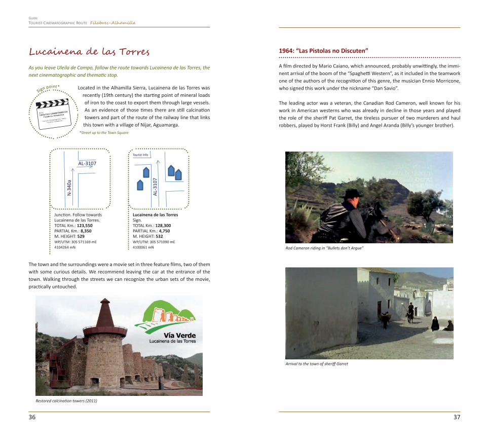
Lucainena de las Torres 1964: “Las Pistolas no Discuten”
A film directed by Mario Caiano, which announced, probably unwittingly, the immi-nent arrival of the boom of the “Spaghetti Western”, as it included in the teamwork one of the authors of the recognition of this genre, the musician Ennio Morricone, who signed this work under the nickname “Dan Savio”.
The leading actor was a veteran, the Canadian Rod Cameron, well known for his work in American westerns who was already in decline in those years and played the role of the sheriff Pat Garret, the tireless pursuer of two murderers and haul robbers, played by Horst Frank (Billy) and Angel Aranda (Billy’s younger brother).
Rod Cameron riding in “Bullets don’t Argue”
Arrival to the town of sheriff Garret
The town and the surroundings were a movie set in three feature films, two of them with some curious details. We recommend leaving the car at the entrance of the town. Walking through the streets we can recognize the urban sets of the movie, practically untouched.
Restored calcination towers (2011)
3736
Junction. Follow towards Lucainena de las Torres.TOTAL Km.: 123,550PARTIAL Km.: 8,350M. HEIGHT: 529WP/UTM: 30S 571169 mE4104264 mN
AL-3107
N-3
40a
Lucainena de las TorresSign.TOTAL Km.: 128,300PARTIAL Km.: 4,750M. HEIGHT: 532WP/UTM: 30S 571090 mE 4100061 mN
AL-3
107
Tourist Info
Tourist-Cinematographic Route Filabres-AlhamillaGuide
1 · The sheriff Garret coming into the Inn 2 · Inside the Inn 3 · Some extras (guitar player) were the inhabitants of the town
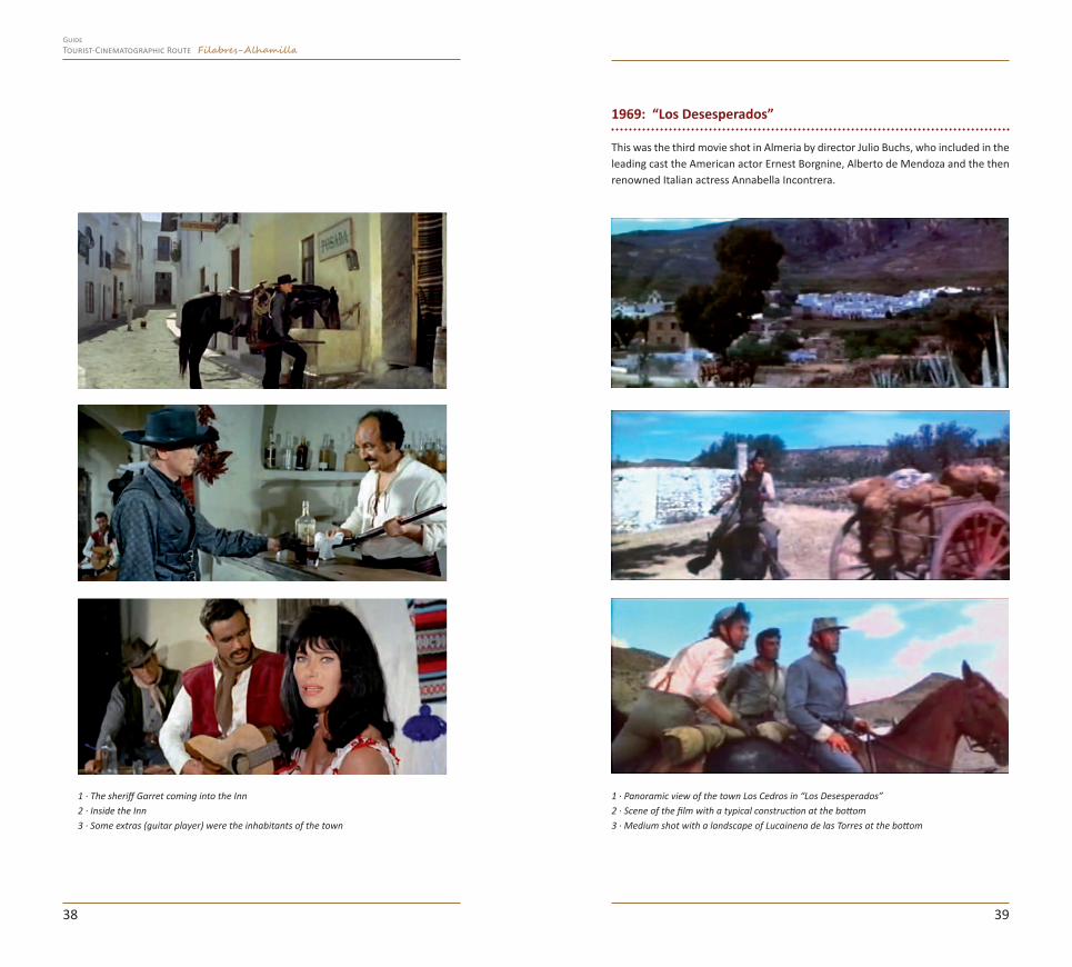
1969: “Los Desesperados”
This was the third movie shot in Almeria by director Julio Buchs, who included in the leading cast the American actor Ernest Borgnine, Alberto de Mendoza and the then renowned Italian actress Annabella Incontrera.
1 · Panoramic view of the town Los Cedros in “Los Desesperados”2 · Scene of the film with a typical construction at the bottom3 · Medium shot with a landscape of Lucainena de las Torres at the bottom
3938
Tourist-Cinematographic Route Filabres-AlhamillaGuide

1970: “La Quebrada del Diablo”
This film features some landscapes of Lucai-nena de la Torres as a background for certain scenes. This was an Italian-Yugoslavian copro-duction, directed by Burt Kennedy and Niska Fulgozi.
The cast had the participation of the director John Huston and Patrick Wayne, the son of John Wayne. Although this last one was one of the greatest figures of the western, he never visited Almeria as an actor.
Suggestions
Visit to the town.
Good cuisine in the different bars of the town del pueblo.
Visit to the church and walk through the streets.
Green path route: 5.5 Km of restored green path under the wing of the Alhamilla Sierra and in time to the watercourse of Lucainena. Travelling through a sunny land among farmhouses, silence, desert, so-litude, mountains and ravines, the stroller enjoys a region of contrasts.
Following in parallel with the green path, we reach Polopos, a village included in the municipal district of Lucainena de las Torres.
4140
Rambla Honda junctionFollow towards Polopos.TOTAL Km.: 131,700PARTIAL Km.: 3,400M. HEIGHT: 495WP/UTM: 30S 573656 mE4099040 mN
Asphalted road with Rambla Honda junction. Follow towards Polopos.TOTAL Km.: 133,000PARTIAL Km.: 1,300M. HEIGHT: 430WP/UTM: 30S 574835 mE4098993 mN
Pass below the Green Path bridge.TOTAL Km.: 133,450PARTIAL Km.: 0,450M. HEIGHT: 415WP/UTM: 30S 575227 mE4099075 mN
Junction at the beginning of the Green Path. Follow towards Polopos.TOTAL Km.: 133,650PARTIAL Km.: 0,200M. HEIGHT: 424WP/UTM: 30S 575392 mE4098993 mN
Paso elevado Vía Verde
Los Ramos. Watercourse passing. Sudden turn to the left towards Polopos.TOTAL Km.: 135,250PARTIAL Km.: 1,600M. HEIGHT: 376WP/UTM: 30S 576782 mE4098533 mN
Old mining train tunnel.TOTAL Km.: 138,000PARTIAL Km.: 2,750M. HEIGHT: 347WP/UTM: 30S 579242 mE4098191 mN
AL-5104
AL-3
107
Tourist-Cinematographic Route Filabres-AlhamillaGuide

About twenty (registered) movies have been shot in the streets and landscapes of Polopos and the so-called “Pun-tal de Polopos”, a hamlet close to the village. Together with Los Albaricoques (a village in Níjar) they offered an ideal set to reproduce Mexican villages or mountains towns of Andalusia and other places.
At present, this area is in ruins, but it is worth a walk from Polopos through the watercourse. With regard to the city centre, Polopos has cinematographic memo-ries in every corner as the general appearance of the village still preserves the taste of the shooting years despite the logical development (asphalted streets, modern constructions, etc.). We suggest a walk through the streets and enjoy recognizing the sites of certain stills.*Church Square
Sign point*
Polopos (Municipal District of Lucainena de las Torres)1968: “Cien Rifles”
An American film, starring Raquel Welch (ca-lled “the body” for her beauty according to the canons of her time). The cast included Jim Brown, the lading actor of another great film shot in the region: “El Cóndor” and other renowned names such as Burt Reynolds, Fer-nando Lamas, Aldo Sambrell, Hans Gudegast and Michael Forest.
They used hundreds of extras for this Ameri-can production. Talking to the press, during an interview, Burt Reynolds said: “I have worked everywhere in the world. Almeria becomes a movie star as it can adapt itself to any film; you can have deserts, oceans, mountains, green landscapes, wheat, it is extraordinarily versatile and you can shoot an ama-zing variety of scenes just here”.
Riding in the streets of Polopos
Raquel WelchPolopos from a baroque church setting (1970)”.
4342
Molinillo bridgeWatercourse passing. Follow towards Polopos.TOTAL Km.: 139,050PARTIAL Km.: 1,050M. HEIGHT: 309WP/UTM: 30S 580037 mE4098031 mN
Turn left. Beginning of the asphalted road. Follow towards Polopos.TOTAL Km.: 139,500PARTIAL Km.: 0,450M. HEIGHT: 294WP/UTM: 30S 580340 mE 4097798 mN
Polopos. SignFollow through Los Ángeles street towards the Church Square.TOTAL Km.: 141,500PARTIAL Km.: 2,000M. HEIGHT: 316WP/UTM: 30S 581849 mE 4098323 mN
Tourist-Cinematographic Route Filabres-AlhamillaGuide

1970: “Tepepa”
Spanish-Italian film of 1970, directed by Giulio Petroni and starring Orson Welles, Tomas Mi-lian and John Steiner. It was shot in several lo-cations of the province, like two towns of the Filabres-Alhamilla Region: Tabernas and Po-lopos (Lucainena de Las Torres, see page 36).
It was the first time that Orson Welles visited Almeria, but it would not be the last one, as he acted in “La Isla del Tesoro” and he shot here a high quality documentary entitled “Fraude” (1973).
Still with a close-up of a leading actor
1970 : “Cabalgando al infierno”
Produced by Dino de Laurentiis, one of the most important and prolific producers of his time. For this shooting they had to assembly the set of a fort (in the area of Tabernas), today disappeared, and a baroque church in the high part of Polopos, from which they shot some scenes. This last construction was made on the basis of a wood and cane struc-ture covered with plaster and paint.
Besides becoming a blockbuster, this film needed the participation of about 2,000 extras and hundreds of horses for the most complex scenes.
Set of a baroque church in Polopos
James Garner in the streets of PoloposOrson Welles in a scene of “Tepepa”
4544
Tourist-Cinematographic Route Filabres-AlhamillaGuide

1970: “Las cuatro plumas”
British feature film, directed by Don Sharp, based in the novel by A.E.W Mason set in Sudan. The African scenes were shot in Almeria.
El Puntal de Polopos1966: “Johnny Yuma”
Still of the film in El Puntal, view of the watercourse
Set of the scenes in Polopos
A film directed by Romolo Guerrieri and produced by West Film and Tiger Film, with location shots filmed in Cabo de Gata-Nijar and the Filabres-Alhamilla Region. The shooting in Almería took about a month and the film had its premiere in the capital seven years later (in 1973). The American actor Mark Damon, the English actor Lawrence Dobkin and the Italian actress Rodalba Neri played the leading roles of this film.
1967: “Tú Perdonas... Yo no”
Still. View of El Puntal farmhouses
1967: “Un Tren para Durango”
This is the third firm of the director Mario Caiano, with a script by Duccio Tessari and the music of the famous Italian composer Carlo Rustichelli. For this production they had to change the appearance of El Puntal constructing a tower that can be seen in some scenes.
General view and thr Tower of El Puntal, set
This Italian-Spanish coproduction was directed by Giuseppe Colizzi, who also par-ticipated actively in the development off the script. It was originally shot with the name of “El gato, el Perro y el Zorro”. This was the first film of the pair of actors Bud Spencer and Terence Hill; the last one was an “emergency” substitute of the actor chosen for the role due to a horse fall. José Salcedo, a regular and a lover of Almería who took part in dozens of shootings, worked as assistant producer for this film.
4746
Tourist-Cinematographic Route Filabres-AlhamillaGuide

Some of the other films shot in Polopos and/or El Puntal de Polopos.
1967 1967
1968 1970
Suggestions
Visit to the town and the surrounding area.
Polopos is the end of the general movie route in the Filabres-Alhamilla region. In the route book, the route finishes in Lucainena to take the A-road 340 a again towards Tabernas, if you want to follow the two arterial supplementary routes (very recommended).
End of the Tabernas-Polopos MainTourist-Cinematographic Route of the Filabres-Alhamilla region
To be continued...
4948
Tourist-Cinematographic Route Filabres-AlhamillaGuide
AL-3
107
Touristinformationoffice
Church Square of PoloposTo continue the route, return to Km. 128,300. Lucainena de las Torres.TOTAL Km.: 141,650PARTIAL Km.: 0,150M. HEIGHT: 319WP/UTM: 30S 581941 mE4098416 mN
Iglesia
Lucainena de las TorresTourist information office. Green Path starting point.. TOTAL Km.: 155,125PARTIAL Km.: 13,475M. HEIGHT: 530WP/UTM: 30S 571050 mE 4100198 mN
Church

ROUTE 2: Tabernas Arterial Route
Tabernas gives its name to the protected natural site known as Tabernas Desert, considered to be the only desert in Europe.
Its arid appearance can be perceived in every hollow, in every spot of this landscape of an exceptional beauty and outstanding ecological interest. Thanks to the origina-lity of the geological formations, eroded by rain and wind, it can turn into remote places and to “wear full dress” to become the silent protagonist of battles, love stories, hate and pursuits.
Sign point*
We remind you that whenever you are in a protected area, you must observe the rules for the use and enjoyment of the environment.
Did you know...
The Tabernas Desert offers more than 3,000 hours a year of sun, rainfalls bet-ween 200 y 250 mm/year and variable temperatures between -5ºC y 48ºC.
The diversity of vegetable species and the configuration of the landscape make it an ideal shelter for migratory steppe birds, as well as the varied animal spe-cies typical of arid areas.
11,625 hectares covering the municipal districts of Alboloduy, Gádor, Gérgal, Santa Cruz and Tabernas.
It was declared Protected Natural Site on 28th July 1989.
The history of Tabernas goes back to the Roman and Mus-lim periods, when it was an important passing way between
the provinces of Almeria and Murcia. Its Nasrid fortress-castle (11th-12th century) bears witness of numerous episodes of the Andalusian history of this land, including the reconquest of Almeria in 1489.
Tabernas Castle
Tabernas CastleSigns. Viewpoint with views of the Desert. Pedestrian visit.TOTAL Km.: 0PARTIAL Km.: 0M. HEIGHT: 498WP/UTM: 30S 553884 mE4101013 mN
In the Tabernas castle “El Zagal” (the Valiant) made official the voluntary surrender of the keys of the capital to the Catholic Monarchs, who stayed in the rooms of his castle.
Die to its appearance and its privileged location in the highest part of the town, with a view to the arid landscape of the desert, it was used as a movie location in films like “Patton”, “Orgullo de Estirpe” or the recent “Tirante el Blanco”, among others. *Viewpoint and Tower
“Tex e Il Signore Degli Abissi” (1985)
“The Maidens’ Conspiracy” (2006)
From the viewpoint of the castle, you can see other traditional shooting spots, such as La Tortuga (Rambla del Búho), the Cerro “Cabeza del Águila” (Eagle Head) or Ce-rro Castillejo or the Llano del Búho.
5150
Tourist-Cinematographic Route Filabres-AlhamillaGuide

Sign point*
1968: “The Valley of Gwangi”
The “Valle de Gwangi” was a revolutionary production for the special effects used in the recreation of big creatures of
old times. The landscapes of the Tabernas Desert were a great support, besides the streets of the town.*Main square
The town of Tabernas has also been used as a movie set recently, using the streets and facades as resources and, sometimes, in inside settings assembled for the oc-casion.
Junction with Alcazaba street. Follow towards Ricardo Fábrega avenue.TOTAL Km.: 0,729PARTIAL Km.: 0,129M. HEIGHT: 425WP/UTM: 30S 554175 mE 4101236 mN
Ricardo Fábrega avenue. Turn to the right. Follow up to Andalucía avenue.TOTAL Km.: 1,000PARTIAL Km.: 0,271M. HEIGHT: 424WP/UTM: 30S 554328 mE 4101012 mN
Gila Golan in “The Valley of Gwangi” (1969)
After the visit to the Castle and following the route book, go down to the town of Tabernas and cross it towards Almeria.
Path down the Castle. End of the pedestrian route.TOTAL Km.: 0,600PARTIAL Km.: 0,600M. HEIGHT: 435WP/UTM: 30S 554013 mE 4101115 mN
1 · Tabernas general view 2 · Some locals acting as extras 3 · Tabernas facade
2003: “Jericho Mansion”
5352
Tourist-Cinematographic Route Filabres-AlhamillaGuide

Following Las Angustias street, you leave the town towards Almeria. In the N-340a, you pass a crossing to the left (just after a small bridge).WARNING, it is forbidden to turn left, so you must look for the U-turn in the roundabout, about 6 Km from here (towards Almeria).
Once you are going in the right direction, take the curve (to the right) and follow the watercourse to the right (following the Route Book), up to the so-called in the movie argot, “Rambla Roja”, this is, the Rambla de la Sierra.
Town Square. SIGN. Continue through the Las Angustias avenue up to the Tabernas exit.TOTAL Km.: 1,312PARTIAL Km.: 0,312M. ALTURA: 384WP/UTM: 30S 554117 mE4100740 mN
*At this point, you can also leave the car and follow the entire route or a part of it on foot.
Tourist Office and public Parking.TOTAL Km.: 1,750PARTIAL Km.: 0,438M. HEIGHT: 380WP/UTM: 30S 553681 mE 4100706 mN
Tabernas exit with N-340A junction. Turn to the left towards Almería.TOTAL Km.: 2,238PARTIAL Km.: 0,488M. HEIGHT: 375WP/UTM: 30S 553300 mE 4100565 mN
Entry to Rambla Puente Moreno CAUTION: U-turn in 6 Km (turn left unauthorized).TOTAL Km.: 3,031PARTIAL Km.: 0,793M. HEIGHT: 355WP/UTM: 30S 552905 mE 4099885 mN
*Exit of the N-340A and road down to the watercourse area. Bifurcation: turn to the right of the watercourse.TOTAL Km.: 3,193PARTIAL Km.: 0,162M. HEIGHT: 347WP/UTM: 30S 553046 mE 4099908 mN
Rambla Los Molinos with Ram-bla de la Sierra junction.TOTAL Km.: 3,400PARTIAL Km.: 0,207M. HEIGHT: 348WP/UTM: 30S 553200 mE 4099839 mN
Rambla de la Sierraor “Cañon Rojo”.SIGN. Return to Km. 3,193TOTAL Km.: 3,842PARTIAL Km.: 0,442M. HEIGHT: 349WP/UTM: 30S 553526 mE4099776 mN
Sign point*
This is a beautiful and original watercourse made up of reddish sediments, hence its name and its movie tradition.
*The edge of the watercourse
Rambla Roja or Rambla de la Sierra
Go back to the crossing and follow under the bridge towards the movie settings of Fort Bravo. Following the watercourse we will get deeper into the landscape of the desert close to the town of Tabernas. These spots, with contrasted colours and va-ried landscapes, from watercourses to plains and hills, inspired and keep on inspiring the creativity of directors and producers …
Pass below the bridge. Continue through the watercourse. Track for vehicles. Sign towards movie settings.TOTAL Km.: 4,664PARTIAL Km.: 0,822M. HEIGHT: 347WP/UTM: 30S 552963 mE 4099967 mN
Watercourse junction in a paved dirt track. Turn right and follow ahead.TOTAL Km.: 5,402PARTIAL Km.: 0,738M. HEIGHT: 328WP/UTM: 30S 552378 mE 4100282 mN
Watercourse junction. Turn left. Unpaved road.TOTAL Km.: 5,479PARTIAL Km.: 0,77M. HEIGHT: 346WP/UTM: 30S 552343 mE4100211 mN
After taking the curve towards “la Tortuga” (towards the Fort Bravo settings to the left), there is a small cave bored through the wall next to the ruins of an old ranch. Maybe it was an old shepherd shelter, an ideal place to shoot some scenes of the film “El Bandido Malpelo” by director Giusepe Scotese.
“El Bandido Malpelo” by director Giusepe Scotese (1970)
5554
N-3
40a
Sign towards movie settingsFORT BRAVO
Tourist-Cinematographic Route Filabres-AlhamillaGuide
Touristinformationoffice
“I Want him Dead” (1968)
“Ben and Charlie” (1972)
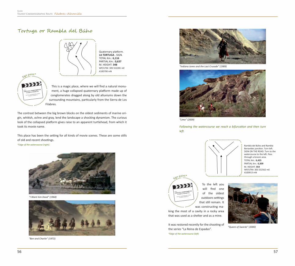
Sign point*
This is a magic place, where we will find a natural monu-ment, a huge collapsed quaternary platform made up of
conglomerates dragged along by old alluviums down the surrounding mountains, particularly from the Sierra de Los
Filabres.
The contrast between the big brown blocks on the oldest sediments of marine ori-gin, whitish, ochre and gray, lend the landscape a shocking dynamism. The curious look of the collapsed platform gives raise to an apparent turtlehead, from which it took its movie name.
This place has been the setting for all kinds of movie scenes. These are some stills of old and recent shootings. *Edge of the watercourse (right).
Tortuga or Rambla del Búho
Quaternary platform. LA TORTUGA . SIGN.TOTAL Km.: 6,116PARTIAL Km.: 0,637M. HEIGHT: 348WP/UTM: 30S 552281 mE 4100790 mN
“Indiana Jones and the Last Crusade” (1989)
“Limo” (2009)
Following the watercourse we reach a bifurcation and then turn left.
Sign point*
To the left you will find one of the oldest
outdoors settings that still remain. It
was constructing ma-king the most of a cavity in a rocky area that was used as a shelter and as a mine.
It was restored recently for the shooting of the series “La Reina de Espadas”.*Edge of the watercourse (left)
“Queen of Swords” (2000)
Rambla del Búho and Rambla Benavides junction. Turn left. SIGN ON THE ROAD. Turn to the watercourse to the left. Pass through a broom area.TOTAL Km.: 6,425PARTIAL Km.: 0,309M. HEIGHT: 354WP/UTM: 30S 552562 mE 4100913 mN
5756
Tourist-Cinematographic Route Filabres-AlhamillaGuide

Following the watercourse, we reach a bifurcation when we turn left.
Sign point* Valle del Búho viewpoint
This valley and its surroundings are emblematic places in the movie world and their varied natural scenarios have
been chosen many times. An illustrative example was the shooting of the Battle of El Guettar of “Patton” in 1969.
*Valle del Búho viewpoint
Rambla del Búho with path up to the Llano del Búho viewpoint junction. Turn left. Paved road.TOTAL Km.: 7,048PARTIAL Km.: 0,623M. HEIGHT: 387WP/UTM: 30S 552511 mE 4101508 mN
Llano del Búho viewpoint. Sign. To follow the route, return to the km. 7,048.TOTAL Km.: 8,031Km. PARCIAL: 0,983M. HEIGHT: 439WP/UTM: 30S 551612 mE 4101755 mN
Going back to the watercourse from the Búho viewpoint, you will go straight past the first crossroads (see the Route Book) and in the second crossing you turn left to go deeper into the so called Paraje Balsa de Gérgal through the Rambla Benavides.
Watercourse junction. Follow straight ahead. Paved path.TOTAL Km.: 8,973PARTIAL Km.: 0,942M. HEIGHT: 387WP/UTM: 30S 552525 mE 4101571 mN
Watercourse junction. Turn to the left. Unpaved road.TOTAL Km.: 9,435PARTIAL Km.: 0,462M. HEIGHT: 387WP/UTM: 30S 552627 mE 4101573 mN
There is a Eucalyptus about 500 m away. Leave the car in the surroundings and continue on foot.
The Battle of El Guetar, “Patton” (1969)”.
Benavides Pool. “Patton” (1969) Gérgal Pool area
Setting between the Valle del Búho and Rambla Benavides. “Patton” (1969) Balsa Gérgal
5958
Tourist-Cinematographic Route Filabres-AlhamillaGuide
Asphalted road with water-course junction. Cross the watercourse and go ahead. Pass the tunnel up to the Interpretation Centre (up to the right). Narrow asphalted path. Follow ahead.TOTAL Km.: 12,806PARTIAL Km.: 0,901M. HEIGHT: 396WP/UTM: 30S 553783 mE 4101360 mN
Tabernas. Interpretation Centre area. Turn to the right.TOTAL Km.: 13,177PARTIAL Km.: 0,371M. HEIGHT: 426WP/UTM: 30S 554121 mE 4101341 mN
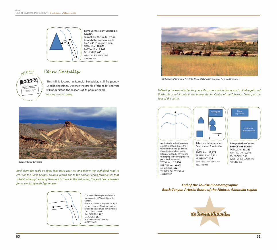
Sign point* Cerro Castillejo
This hill is located in Rambla Benavides, still frequently used in shootings. Observe the profile of the relief and you will understand the reasons of its popular name.
*In front of the Cerro Castillejo
Polideportivo
Following the asphalted path, you will cross a small watercourse to climb again and finish this arterial route in the Interpretation Centre of the Tabernas Desert, at the foot of the castle.
Interpretation Centre. END OF THE ROUTE.TOTAL Km.: 13,222PARTIAL Km.: 0,045M. HEIGHT: 427WP/UTM: 30S 554085 mE 4101333 mN
Centro de interpretacion
Pistas deportivas
Cerro Castillejo or “Cabeza del Aguila”.To continue the route, return towards the previous point.Km 9,435. Eucalyptus area.TOTAL Km.: 10,678PARTIAL Km.: 1,243M. HEIGHT: 400WP/UTM: 30S 553202 mE4102469 mN
End of the Tourist-CinematographicBlack Canyon Arterial Route of the Filabres-Alhamilla region
To be continued...
Back from the walk on foot, take back your car and follow the asphalted road to cross all the Balsa Gérgal, an area known due to the amount of big farmhouses that subsist, although some of them are in ruins. In the last years, this spot has been used for its similarity with Afghanistan
Cruce rambla con pista asfaltada para acceder al “Paraje Balsa de Gérgal”. Giro a la izquierda. A partir de aquí, seguir en coche. No dejar camino asfaltado hasta cruce con ramblilla.Km. TOTAL: 11,905Km. PARCIAL: 1,227M. ALTURA: 387WP/UTM: 30S 552994 mE4101579 mN
“Delusions of Grandeur” (1971). View of Balsa Gérgal from Rambla Benavides
View of Cerro Castillejo
6160
Tourist-Cinematographic Route Filabres-AlhamillaGuide

ROUTE 3: Black Canyon Arterial Route
Sign point* This arterial route starts in the main square of Tabernas. Next we will indicate you the map to follow. You can look up the contents in the pages 14-21 (of the general route) and XXX (of the Tabernas arterial route), coincident with
this one in the first stretch.*Main square
Go towards Serón-Tahal in the road out of the town.
On the way, to the right, besides the solar platform, you can see a huge plain, for-merly used as an aerodrome. Both sites were used as shooting sets and nowadays they are still used for their appearance of big plain.
“The Girl with the Dragon Tattoo” (2009)
“Exterminators in the Year 3000” (1983)
One of the most recent shootings was a final scene of Millenium “Los Hombres que no Amaban a las Mujeres”, when the protagonist goes to Australia to meet the disappeared protagonist. Another scene of this shooting used the desert watercour-ses to reproduce the Australian desert.
After the solar platform of Tabernas, to the left, there is an entrance (without chains) to gain access to a watercourse area.
6362
TABERNASTown Square. SIGN. Start of the movie route. Follow towards Castro de Filabres.TOTAL Km.: 0PARTIAL Km.: 0M. HEIGHT: 384WP/UTM: 30S 554560 mE 4101582 mN
Las Eras Service Station.TOTAL Km.: 0,950PARTIAL Km.: 0,950M. HEIGHT: 438
Est.
Servicio
Junction. Turn to the left towards N-340A.TOTAL Km.: 1,050PARTIAL Km.: 0,100M. HEIGHT: 438WP/UTM: 30S 554605 mE 4101648 mN
Est.
Servicio
Junction. Follow towards Tahal.TOTAL Km.: 1,500PARTIAL Km.: 0,50M. HEIGHT: 440WP/UTM: 30S 554607 mE 4102102 mN
Castro de Filabres-Velefique junction. Follow towards Serón-Tahal.TOTAL Km.: 2,580PARTIAL Km.: 1,080M. HEIGHT: 467WP/UTM: 30S 554797 mE 4103135 mN
N-340A roundabout. Exit from Tabernas. Follow towards Serón-Tahal.TOTAL Km.: 1,450PARTIAL Km.: 0,400M. HEIGHT: 440WP/UTM: 30S 554628 mE 4102065 mN
Tourist-Cinematographic Route Filabres-AlhamillaGuide
Est.
Servicio

As you reach the watercourse area, we advise you to leave the car parked and cover this short walk on foot to apprecia-te the slate landscape, sprinkled with brooms and espartos.
The route covers about 6 km (round trip), surrounded by a movie-like landscape.
*Signs in three points of the route
Sign point*
In the different signs, and with the help of the guide, you will recogni-ze the particular landscape of this watercourse. The end of the route has been marked with a sign of “private property” from where you must go back to the starting point.
THE END
End of the Tourist-Cinematographic Arterial Route of the Filabres-Alhamilla region
The end of a continuous line is here, so you CANNOT turn back. We advise you to go on up to the first crossing that allows to make a U-turn and take the entrance to the Cañón Negro to cover this short but intense route.
Cañon Negro.TOTAL Km.: 10,500PARTIAL Km.: 1,740M. HEIGHT: 627WP/UTM: 30S 555927 mE 4109123 mN
Cañon Negro.THREE SIGNS ALL THROUGH THE ROUTE. TOTAL Km.: 8,760PARTIAL Km.: 0,390M. HEIGHT: 572WP/UTM: 30S 557291 mE 4108093 mN
Undoubtedly, there is much more... but we will tell you in next episodes.“El Tesoro de Manitú” (2001)
“Chato’s Land” (1971)
Cañon Negro.TOTAL Km.: 11,850PARTIAL Km.: 1,350M. HEIGHT: 648WP/UTM: 30S 556345 mE 4110326 mN
Cañon Negro. Arrival to an area in a Private Property. End of the route.TOTAL Km.: 11,950PARTIAL Km.: 100M. HEIGHT: 650WP/UTM: 30S 556354 mE4110445 mN
6564
Junction with Rambla Honda or “Cañon Negro”CAUTION: Solid line. Unauthorized turn to the left. U-turn I the next junction.TOTAL Km.: 8,370PARTIAL Km.: 5,790M. HEIGHT: 566WP/UTM: 30S 557745 mE4108157 mN
A-34
9
Tourist-Cinematographic Route Filabres-AlhamillaGuide