guide of good practice
TRANSCRIPT

Guide of Good Practice
Published by Ellinogermaniki Agogi
GEOTHNK: Semantic pathways for building a spatially-thinking society

GEOTHNK Guide of Good Practice

Published by Ellinogermaniki Agogi
Editors:
Eugenia Kypriotis, Dr. Angelos Lazoudis, Dr. Sofoklis Sotiriou
Authors-Contributors:
National Technical University of Athens, INTRASOFT International S.A., Association of Geographic Information Laboratories for Europe, Casa Corpului Didactic Cluj, Konstantin Preslavsky University of Shumen, Bundesministerium für Bildung und Frauen, Stichting GeoFort
Design:
Makis Mazarakos
With the support of the Lifelong Learning Programme of the European Union
Pr. no 543451-LLP-1-2013-1-GR-KA3-KA3MP
All rights reserved.
Reproduction or translation of any part of this work without the written permission of the copyright owners is unlawful. Request for permission or further information should be addressed to Ellinogermaniki Agogi, Athens, Greece
Printed by EPINOIA S.A.
ISBN: 978-960-473-682-9

Table of Contents1 Introduction 51.1 Introduction 51.2 The GEOTHNK approach 51.3 Impact in Education & Society 61.4 Implementation & Dissemination Events 71. 5 References 15
2 The GEOTHNK Platform 162.1 Functional Requirements 172.2 Usage Scenarios 182.3 Actors Specifications 222.4 Use Case Descriptions 262.5 GEOTHNK Educational Pathway Authoring Tool 35
3 The GEOTHNK Pedagogical Approach 603.1 Pedagogical Principles 613.2 Bridging the gap between formal and informal learning 623.2 Inquiry Based Learning 623.3 Essential features of inquiry in learning environments with the integration and use of technology Establishing inquiry-based learning environment 633.4 GEOTHNK Educational Pathways 643.5 GEOTHNK Pedagogical Pattern 663.6 Space, Representation, and Reasoning 673.7 The GEOTHNK approach: how do we promote spatial thinking? 743.8 The GEOTHNK approach: how do we promote spatial thinking? 753.9 References 76
4 Educational Scenarios 804.1 Introduction 814.2 Educational Scenarios 824.3 Define questions from current knowledge 92
5 Validation 985.1 Introduction 995.2 Methodology-Validation Design 995.3 Results 1015.4 Appendix 126

1Introduction

5
Introduction
1.1 IntroductionGEOTHNK has been shaped on the fact that spatial thinking is considered as a key ability for the STEM dis-
ciplines (Science, Technology, Engineering, and Mathematics). Although, research results stress the reward-ing effects of developing geospatial skills in growing the participation in STEM disciplines, whose lack acts as a barrier for students leading them to dropout. Furthermore, spatial thinking is a vital talent for achieving STEM innovation, but due to being neglected by educational systems it has been missed: “Individuals with such talents constitute a lost resource for creating future STEM innovation, since 90% of STEM doctorate holders scored in the top quartile of spatial ability during adolescence”.
Lately, spatial thinking has also been acknowledged as highly relevant to social sciences and humanities, as well as significant for several tasks required in everyday life, such as giving and following directions, navigating in known and unknown spaces, and interpreting images, graphs, and diagrams. Additionally, com-prehending central visual-spatial notions such as scale and generalization finds also its cognitive analogy to the way people learn, communicate, or deal with (not necessarily spatial) everyday life issues. It actually constitutes a very important and new approach to learning (learn-to learn), differing from the more established auditory-sequential type of learning.
GEOTHNK through its lifetime has focused on shaping the ground for the development of geospatial skills through the training of teachers, students and adults in correlating material coming from different disciplines, and resources, engaging also critical thinking and reasoning, including spatial thinking, and on the enhance-ment of research into best practices in presentation, exploration, and visualisation of geospatial information, especially through the creation of interoperable semantic networks.
1.2 The GEOTHNK approachThe GEOTHNK approach supports learners (students, university students and adult learners) to apply spa-
tial thinking and purposefully address spatial concepts, across all curricular areas and at any developmental level. This approach enables them to grasp the interdisciplinary character of fundamental spatial concepts. At the same time, it grounds the coherence of the curriculum, reveal interrelations among disciplines and apply fundamental reasoning and thinking to everyday life developing problem-solving skills of the target groups.
As a strategy it includes the development of the GEOTHNK pedagogical framework and a series of learning

6
pathways that have acted as demonstrators and best practices of the proposed approach. The technologi-cal approach included the development of the GEOTHNK educational platform. The vision was to develop a socially empowered platform that allows users to search for resources, to share lesson plans, to exchange information and resources. The platform supports educators to develop state-of-the-art pathways that reveal learners innovative ways to relate geospatial concepts with concepts from other disciplines (e.g., Environ-ment, Earth Sciences, Social Sciences, etc.) and deduce and associate knowledge, e.g., explore historical events that coincide in space and time, or understand the correlation of physical and cultural phenomena.
The GEOTHNK educational platform development embraces a sharing design that interrelates the peda-gogical approach and the technological development that deployed to support the users’ needs. This partici-patory design has ensured the ongoing identification, update, and integration of multi-perspective and multi-user necessities and it had secured the development of an effective and easy to use GEOTHNK interface that also meets the needs of the proposed pedagogical framework. Along, the outcomes of the needs analysis have been taken into serious consideration on multiple levels regarding the requirements of all practitioners (teachers, students, adult learners, teachers trainers, museum staff) and that also offered value to the GEO-THNK platform in a way that meets the requirements of all different target groups and a formative user experi-ence evaluation through the validation plan that gave respective feedback to the work that was related to the pedagogical design and the technology development.
1.3 Impact in Education & SocietyGEOTHNK has concentrated to the teachers and their students, to teachers trainers, to University students
to science center educators and to adult learners.
For teachers, teachers trainers and university students, GEOTHNK offers pedagogical “plug, share, and play” through a Web-based interface and a community framework to disseminate best practices and find mutual support. A modular approach and innovative pathways that crosscut the boundaries between formal and informal learning settings promote a seamless incorporation of numerous open educational resources into the classroom.
For science center educators, GEOTHNK provides open interfacing solutions to easily prepare learning pathways for their communities (visitors), construct their virtual didactic counterparts, and share them with teachers and researchers in the field.
For adult learners (e.g. science centres visitors), GEOTHNK offers the opportunity to be involved in innova-tive learning activities that builds on the strengths of both formal and informal learning that are extended with social communication facilities.
GEOTHNK platform and its integrated tools and resources are based on an open education platform, and remain publicly accessible.

Guide of Good Practice
7
1.4 Implementation & Dissemination EventsSeveral events have taken place regarding GEOTHNK Activities in Bulgaria, Romania, Greece, Austria and
the Netherlands. Below follows an example of a very successful one with great impact to the students.
Hyperglobe Demonstrations, 28.01., 18.05. and 20.05.2015, Vienna
The Hyperglobe allows sensational insights and perspectives on the Earth, as they are normally reserved for spacemen.
On a giant globe sphere with 1.2 m diameter (scale 1: 10 million) can be astonishingly realistic experience the earth - with spectacular views and animations of weather processes, continental drift, flight movements, volcanic eruptions, tsunamis, climate change ....
The form of representation tactile Hyperglobe is particularly suited for schools, science centers, research institutes, museums and for public relations. A Hyperglobe aims clearly, promptly and dynamically visualize various global processes. In particular, new forms of expression with different degrees of complexity and (di-dactic) techniques for optimal processing and visualization of global processes are intended.
The topics of these global stories can be based on current social and geoscientific issues and, inter alia, serve to present research results from different disciplines in a global context. In particular, climate, flora, fauna, environment, ecology, population, culture, history, transport, economic, military, and extraterrestrial themes (planets, moons, universe) can be made available regarding geological and geophysical processes and threads.
Demonstration for classes from three schools (secondary education, ages 9-10) was organized in coopera-tion with the GEOTHNK project in Vienna. One of the schools has chosen the time zones as main topic at this time in the subject geography.
As preparation for the visit and demonstration with the Hyperglobe the current time at several cities on the whole Earth were shown in the classroom. The times were chronological ordered and a relation between this order and geographical positions in an atlas were explored and discussed. Also some flight routes were checked within Europe for their total flight times, the departure and arrival times and written in a protocol.
The classes visited on the given days the Department of Geography and Regional Research which hosts one Hyperglobe in a building of the University of Vienna. The Hyperglobe scenario about the time zones of Earth have been shown and a lively discussion between school children, teachers and researchers took place. The pupils observed and investigated how day and night on Earth evolves and selected distinct coun-tries or cities and calculated differences in time between two points on Earth. Another Hyperglobe scenario showed the global flight traffic during day and night changes.

8
Apart from the very basic workshops and presenta-tion of GEOTHNK to local educational communities there were also some events that required special treatment.
The GEOTHNK Summer SchoolThe Summer School was a course centred on the
development of an important ability both for scienc-es and everyday life: geospatial thinking. It actu-ally constituted a very important and new approach
to learning (learn-to learn), differing from more established learning approaches. The course addressed to teachers across all subject areas who are interested in developing their own as well as their students’ geospatial thinking skills.
The aim of the course was twofold: firstly, to acquaint the participants with this important form of thinking and secondly, to support them in applying innovative teaching methods for enhancing their students’ geospatial thinking skills with the use of information technologies. Participants made use of an open, collaborative educational environment and a collection of open educational resources and tools in order to develop educational scenarios across different subject areas that will expand the limitations of classroom instruction.
The course included lectures, group-work, training on the educational platform, and activities of playful learning supporting critical thinking and understanding of scientific concepts.

Guide of Good Practice
9
A special website has been created to communicate the Summer School news
Also a special community has been created in the GEOTHNK environment where resources were stored and also participants could interact even before the beginning of the Summer School and they had the op-portunity to introduce themselves.
Picture 1.4a Summer School homepage

10
Picture 1.4 c Supporting material
Picture 1.4b Summer School Community in GEOTHNK platform

Guide of Good Practice
11
Also, all tutors’ presentation were uploaded real time, support material could be easily searched and last participants could upload the educational material they have developed.
Participants were coming from Roamania, Serbia, Finland and Greece and they have all created rich GEO-THNK scenarios. GEOTHNK Summer School was considered as a success and here are some comments from the participants.
The GEOTHNK International Scenario ContestThe contest took place in May 2015 and it was open to the educational community. All the participation
however had to be in the English language so that they could be comparable. The registration and all the participation procedures had to be followed within the GEOTHNK environement.
The successful scenarios should:
• enable the development of geospatial thinking through educational objectives
• be complete and properly structured according to the Inquiry Based Model
• make use of modern and innovative teaching methods and approaches
• support interdisciplinarity
• combine also informal education context
• provide multiple means of action and expression
• encourage engagement throughout the learning process
• take into account imagination and the creative and entertaining features of knowledge
• make use of digital resources
• emphasize the development of students’ skills and their personalities
For the needs of the contest a special community was also created in order to contact with those interested.
“The whole atmosphere was great. The location was very good and the bal-ance between the lessons, workshops, activities and spare time was very good. Of course the topics were interesting.”
“I had the opportunity to elaborate with teachers from different countries, ex-change ideas and learn about very use-ful tools which otherwise it could very difficult for me to find out.”

12
Overall, 28 participants have participated with very intersecting scenarios which made the selection very difficult. The winners have won scholarships for the GEOTHNK Summer School.
Picture 1.4 d GEOTHNK International Scenario Contest Community

Guide of Good Practice
13
GEOTHNK Closing ConferenceThe GEOTHNK INTERNATIONAL CLOSING CONFERENCE “EDUCATING THE FUTURE SPATIAL CITI-
ZENS” took place in Athens, on the 7th of November 2015 in the premises of Ellinogermaniki Agogi at Pallini, Athens. The participants had the opportunity to attend very interesting presentation about the geospatial skills and their development.
The Conference mainly focused on presenting the outcomes of the GEOTHNK Project. However, contribu-tion by educators & researchers working on relevant issues around the world was encouraged and expected. The concentarion was around spatial thinking, geospatial education, geospatial semantics in education, ICT platforms for spatial teaching and learning and digital agenda for Europe.
The invitation was open to GEOTHNK project participants and community, educational practitioners of all levels (teachers, tutors, professors, etc.), academic students, post graduates and doctorate candidates, adult learning instructors and heads of education departments from private or state institutions, academics, re-searchers and teachers.
Also, the dissemination activity has been very powerful. The tables below show the activity in two of the most popular social media Facebook and twitter.
Picture 1.4 e GEOTHNK Closing Conference

14
Also, in the cases of the GEOTHNK Closing Conference and the GEOTHNK International Scenario Contest special dissemination material has been produced. In some cases poster shave been translated in other languages apart from English.
Regarding the publications and the presentations below there is a pie showing the activity
Picture 1.4 f GEOTHNK posters

Guide of Good Practice
15
And this pie shows the activity of disseminating local events.
1. 5 ReferencesUttal D. H. & Cohen C. A. (2012). Spatial Thinking and STEM Education: When, Why, and How?. Psychol-
ogy of Learning and Motivation.
Goodchild, M., & Janelle, D. (2010). Toward critical spatial thinking in the social sciences and humanities. GeoJournal, 3-13.
National Research Council (NRC), 2006. Learning to Think Spatially: GIS as a Support System in the K-12 Curriculum, Washington, D.C.: The National Academies Press, http://www.nap.edu/catalog.php?record_id=11019

2The GEOTHNK Platform

17
The GEOTHNK Platform
The software development methodology applied in GEOTHNK is the “Rational Unified Process” (RUP). RUP as a commercial product consists of an online knowledge-based, templates for different third party applica-tions and a development kit. In addition it is supported by several tools, which automate large parts of the process. It is continually updated and maintained by the integration of experiences and proven best practices. The product itself was not user but leveraged the process methodology as it is described in several publica-tions.
RUP is very valuable for GEOTHNK. On one hand, GEOTHNK as an innovative initiative requires a software development process, which is flexible enough to handle changing requirements and to adjust technical con-cepts if necessary. On the other hand, the process must be rigorous enough to ensure high quality from the requirements analysis and system design over implementation to testing
It is in the nature of such initiatives that initial concepts are adjusted over time. Therefore, system require-ments, as the basis of the system, have to be controlled in a very rigorous way. This fact also requires an iterative approach to software development. The use cases are a suitable means for communicating and collaborating.
As already stated above, GEOTHNK does not employ RUP by using respective product suites. Instead, the methodology itself is applied and adjusted to its needs. Since RUP provides a structured and detailed framework, it can be applied to structure subsequent phases, particularly system design, implementation, and testing.
2.1 Functional RequirementsThis chapter focuses on the first step of the development life-cycle, namely requirements analysis, by ini-
tially defining usage scenarios, identifying the main actors and afterwards discussing functional requirements throughout a series of use cases.
Moreover, given that the educational environment of the GEOTHNK is integrated to the ISE Portal in the form of a community, the GEOTHNK educational environment inherits various features and functionality of the ISE and the ODS Portals. Therefore in order to avoid duplication or repetition of the base-line specifications, the reader is re-directed to deliverables of ISE and ODS whenever required.

18
2.2 Usage ScenariosThis section describes scenarios of usage for the GEOTHNK platform to identifying the most common user
functionality. Usage scenarios take the form of short stories describing the interaction of the users with the GEOTHNK platform.
The scenarios here described focus on the main elements of the GEOTHNK, which refer to the functionality that supports the creation of Educational Pathways and the use of the main resources for geospatial thinking. The GEOTHNK platform will benefit from the socially-empowered services of the ODS platform as soon as the GEOTHNK portal is integrated as a community of the ISE Portal.
1. First Encounter with the GEOTHNK platform: The GEOTHNK platform takes the form of a community of the ISE Portal. The GEOTHNK community pro-
vides access to the following information and services:
a. User support services for registration and login.
b. Service to search for GEOTHNK sub-communities inside the ISE Portal.
c. Service to search for Users registered as members of the GEOTHNK community and sub-communities.
d. A “Resources” section provides access to services for sharing and searching for GEOTHNK resources including Educational Pathways, as well as Concepts, Reasoning and Representation tools.
e. A “Community Building” section provides access to social-oriented services supported by the ODS plat-form such as Activities, Events, Discussions, Blogs, Discussions and Polls.
2. User AccessAnonymous users that want to exploit the social and share services of the GEOTHNK community need first
to register and login to the GEOTHNK community. From the Register link of the GEOTHNK community the user opens up a registration form. During sign-up the user declares his/her member-type, organization/institu-tion, role/position, user name and email address. The Portal informs the user of the terms and conditions for the use of the service. An email is sent to the GEOTHNK community manager and the corresponding mes-sage notification appears at his dashboard to inform him for the registration request. The GEOTHNK com-munity manager follows the provided link to either accept or reject the request. In the accept case an email is sent to the user with a unique URL that activates his personal account in the ISE portal. In the reject case an email is sent with the reason of rejection.

Guide of Good Practice
19
3. User’s dashboard The dashboard interface presents the user with information on his/her profile. From the bookmark list, the
user can access educational resources he has previously bookmarked. Whenever the user requests to join a group, a message appears in his dashboard with the answer of the group’s moderator. Moreover there is a section for each of the social services available in the platform, which provides access to the specific discus-sions, blogs, etc., where the user participates. Finally in the section Educational Objects the user has access to all the Resources he has created.
4. Share Educational ObjectsA registered user is able to share Educational Objects to a specific GEOTHNK community. The user enters
the “Resources” area of the community and chooses to share Educational Objects. A new webpage opens with a submission form to be completed with metadata (e.g., title, description, educational context.). The user can submit the content through a URL or can upload a file.
5. Share Educational PathwaysA registered user is able to share Educational Pathways to a specific GEOTHNK community. The user
enters the Resources area of the community and chooses to share Educational Pathways. A new webpage opens that provides access to the GEOTHNK authoring tool. The creation of Educational Pathways is orga-nized in two stages. In a first stage, the content of the Educational Pathway is provided. The content is divided into fixed phases depending on the chosen pedagogy. Each phase has activities. For each activity it will be possible to add the core elements of spatial thinking, including (a) geospatial concepts, (b) representation tools, and (c) reasoning tools. It is compulsory to add at least one geospatial concept per activity. Adding the core elements of geospatial thinking can be done by selecting from existing ones. Adding of new elements is only allowed for reasoning tools and educational objects. In the second stage, the Educational Pathway is enriched with compulsory and optional metadata. While editing the Educational Pathway, the default status of the resource is “draft” which means it is private to the user. Only until the user provides all the compulsory content and metadata, the user can publish the resource so it can be searchable from the community.
6. Share Reasoning ToolsA registered user is able to share Reasoning Tools to a specific GEOTHNK community. The user enters
the Resources area of the community and chooses to share Reasoning Tools. A new webpage opens with a submission form where the user has to provide, name, tool owner, description and URL.
20
7. Search for Educational ResourcesA user can search for educational resources by navigating to the Resources area of the community and
chooses the option Search Educational Resources. A new webpage, from now on called “Search Webpage”, is opened presenting the different search tools that can be used to search the repository. Depending on the tool a different input is required. Once the required input is provided a list of search results is presented, which can be filtered through different options e.g., discipline, target audience, context, etc. The user can click on the title of a resource from the list of search results to access the summary page of the object.
8. Keyword based SearchA user can use this search tool to look for all types of Resources, including Educational Objects, Learning
Pathways, Geospatial Concepts, Reasoning tools and Representation Tools of a community. This tool is ac-cessible from the Search Webpage once the user selects the type of resource he looks for.
9. Map-based SearchA user can use this search tool to look for Educational Pathways of a community. This tool is accessible
from the Search Webpage once the user selects the option to search resources from the community. With the Map-based search the user navigates in a map to look for markers. If the user clicks on a mark the search tool uses the associated geographical instance as input to look for Educational Pathways that have used the corresponding geographical instance.
10. Graph-based SearchA user can use this search tool to look for Educational Pathways of a community. This tool is accessible
from the Search Webpage once the user selects the option to search resources from the community. With the Graph-based search the user is able to navigate a semantic network of geospatial concepts (nodes) and relations between them (edges) in a graph tool. If the user clicks on a node in the graph, the search tool uses the associated geospatial concept as input to look for Educational Pathways that have used the correspond-ing concept. The user is also able to select concept instances associated to the nodes. Every time a node is selected the associated concept description is visible.
The user can explore the semantic network by zooming-in and out, as well as pan, and can differentiate between concepts that have related Educational Pathways by the size of the node. The size of the node indi-cates an amount. The bigger the size of the node, the more Educational Pathways that are associated to the concept and that can be retrieved as part of the search result. When the user clicks on a node, the node is highlighted with a different colour to indicate that it has been chosen and used for the search. The user can click on more than one concept and use them all as input for the search. The edges that directly or indirectly

Guide of Good Practice
21
relate all the selected concepts are highlighted as well.
11. Search Representation ToolsAny user registered or unregistered is able to browse the Representation Tools of the GEOTHNK com-
munity. The user navigates to the Resources area of any GEOTHNK community and chooses to search for Representation Tools. The Search Webpage is opened containing the list of all available representation tools for the GEOTHNK community. The user can use the keyword-based tool to search for a specific tool or use the Categories filter to reduce the search space to his convenience. With a click on the title of a tool, the sum-mary page of the tool opens.
12. Search Reasoning ToolsAny user registered or unregistered is able to browse the Reasoning Tools of the GEOTHNK community.
The user navigates to the Resources area of any GEOTHNK community and chooses to search for Reason-ing Tools. The Search Webpage is opened containing the list of all available reasoning tools for the GEO-THNK community. The user can use the keyword-based tool to search for a specific tool. With a click on the title of a tool, the summary page of the tool opens.
13. Open a ResourceTo open a resource the user has to first navigate to the Resources area of the community, make a search,
finally from the search results click on the headline of the resource he is interested in. The summary page of the resource can be opened containing a short description, and other relevant metadata such as title, author, provided keyword, tags, user ratings date, user comments, recommendations, etc. The user can tag, com-ment, bookmark and rate the resource. Additionally, the user has the option to report inappropriate comments or content. If the user finds the resource interesting, he/she can store it in their favorites for later use.
14. View Resources and ToolsThe user navigates to the summary page of a resource or tool and chooses the View icon that provides ac-
cess to the content of the resource which is most commonly a URL. If the resource is an Educational Pathway a webpage is opened that shows the content of the pedagogical scenario, as well as the associated resources attached to each activity in the scenario. Finally also a graph view of the Educational Pathway is accessible when the user clicks on a graph icon, which opens a graph tool that highlights the nodes that are used in the Educational Pathway and the edges that directly or indirectly relates the nodes. The user can zoom-in, zoom-out and pan the graph.
22
2.3 Actors SpecificationsThis section presents the actors’ specifications along with the corresponding actions that each actor will be
able to perform within the GEOTHNK community.
2.3.1 Teacher
Teacher Actor Specification
Actor Name Teacher
Brief DescriptionTeacher is an actor that has a user account. The Teacher is considered as the main role of the
GEOTHNK Communities. He is able to search and retrieve both learning content and social net-work information, and formulate groups of interest, have full social network interactions, such as participation to activities, events, polls, discussions, blogs, creating, uploading.
Available Actions• Register to the GEOTHNK Community• Login to the GEOTHNK Community
Educational Resources:• Search for Educational Resources in the GEOTHNK Community• Search for Educational Resources in the ISE Portal• Search for Tools in the GEOTHNK Community• Share Reasoning Tools to the GEOTHNK community• Share Educational Objects to the GEOTHNK community• Share Educational Pathways to the GEOTHNK community• Navigate to the GEOTHNK Authoring Tool • Create a new Educational Pathway based on an existing one• Search for Educational Resources and Tools while editing an Educational Pathway• Search the Semantic Network of Geospatial Concepts while editing an Educational Path-
way.• Attach Educational Resources and Tools to the activities of an Educational Pathway• Attach Concepts from the Semantic Network to the activities of an Educational Pathway• Attach Concept Instances to the activities of an Educational Pathway• Remove Educational Resource and Tools from the active Educational Pathway • Save the Educational Pathway as draft for private access• Save the Educational Pathway as public• Add comments to Resources• Delete his own Resources

Guide of Good Practice
23
Table 1. Teacher Actor Specification
2.3.2 Teacher trainersThis is a role sharing the same access rights as the teacher (see Table 1).
2.3.4 Science centre educatorsThis is a role sharing the same access rights as the teacher (see Table 1).
Available ActionsSocial-oriented services:Communities:
• Create Community• Request to Join a Community
Discussions:• Create a discussion• Manage Discussion• Annotate a discussion
Activities:• Create a Training Activity• Edit a Training Activity • Participate to an Activity
Events:• Create an Event• Manage an Event• Edit Event Information
Blogs:• Create Blog• Edit-update blogs
Groups:• Create a Group• Join a Group• Leave a Group
Poll:• Manage Poll• Create Poll

24
2.3.5 University studentsThis is a role sharing the same access rights as the teacher (see Table 1).
2.3.6 Web visitor
Table 2. Web Visitor Actor Specification
Student Actor Specification
Actor Name Web visitor
Brief Description Web visitors are actors that do not have a user account to the Portal or they are not logged-in.
Available Actions • Search for Educational Resources in the GEOTHNK Community• Search for Tools in the GEOTHNK Community• Search for Educational Resources in the ISE Portal.• Request Analyst Privileges• Find an Event• Find a Poll• Navigate to Blogs • New User Registration• Share an Event• Find Community Members• Register to the GEOTHNK Community

Guide of Good Practice
25
2.3.7 Community Administrator
Table 3. Community Administrator Actor Specification
2.3.8 Analyst
Table 4. Analyst Actor Specification
Community Administrator Actor Specification
Actor Name Community Administrator
Brief Description Any user registered as a Teacher can become a Community Administrator. Administrators will be able to delete inappropriate content, certify and rate content. Also, they will be able to moni-tor participants’ interactions for signs of inappropriate behavior. In addition, they will be able to configure the community’s features and permissions.
Available Actions • Accept Community Registration Requests• Reject Community Registration Requests• Invite People to Join Community• Manage Community Members• Delete the Community
Analyst Actor Specification
Actor Name Analyst
Brief Description Actors that are interested in the reporting capabilities and activities of a GEOTHNK Community.
Available Actions • View Community Analytics• Login to GEOTHNK Community• Edit user profile• Find Group Members• Search Users
26
2.4 Use Case DescriptionsIn this section only GEOTHNK specific use cases and community use cases are described. Refer to (6) for
a description of the rest of the social-oriented use cases that are supported, e.g., Polls, Activities, Events, Discussions, Blogs and Groups.
2.4.1 User Access
Use Case Name Register to the GEOTHNK Community
Use Case ID UC-1
Actor(s) Teacher, Community Administrator, Analyst
Precondition(s) Navigate to the GEOTHNK Community in the ISE Portal
Post condition(s) The user is registered as a member of the GEOTHNK Community and the ISE Portal
Brief Description The actors have access to the GEOTHNK services (based on their profiles) after being registered to the GEOTHNK community. To be registered, the actors have to visit the ISE Portal and navigate to the GEOTHINK Community and ask for registration. The user provides the required informa-tion regarding his account and personal details. After entering correctly this information, a request is sent to the GEOTHNK community administrator for approval. After the approval, a notification is sent to the actor with special guidelines on how to access the ISE Portal and admin their own profile.
Associated Use Case(s) Login to the GEOTHNK Community

Guide of Good Practice
27
Table 5. Register to the GEOTHNK Community
Activity Diagram

28
Table 6. Login to the GEOTHNK Community
Use Case Name Login to the GEOTHNK Community
Use Case ID UC-2
Actor(s) Teacher, Community Administrator, Analyst
Precondition(s) The user has registered to the community
Post condition(s) The user has access to the GEOTHNK community services (based on their profiles) after being registered to the GEOTHNK community.
Brief Description The actor enters his credentials to the ISE Portal in order to login. In case he does not remem-ber the credentials, he uses his username or his e-mail account to receive a reminder and then access then login. In any case, when the user provides correctly his username and password then he accesses the ISE Portal as a logged-in user with credentials as well for the GEOTHNK community.
Associated Use Case(s) Register to the GEOTHNK Community
Activity Diagram

Guide of Good Practice
29
2.4.2 GEOTHNK Communities
Table 7. Create a GEOTHNK Sub community
Use Case Name Create a GEOTHNK Sub community
Use Case ID UC-3
Actor(s) Teacher
Precondition(s)The user has registered to the GEOTHNK community
The user has logged in to the ISE Portal
Post condition(s) The user becomes Community Administrator of the GEOTHNK sub community
Brief Description
The user can follow this use case in order to create a new GEOTHNK sub community. The user has logged in to the ISE Portal and navigated to the GEOTHNK community and requests a new community. The user completes the request form and sends the request. If the information provided in the form has been correctly given, then a notification is sent to the community manager’s dashboard of the parent GEOTHNK community. The com-munity manager examines the request and approves or rejects the request. If the request has been approved an e-mail is sent to the actor. The e-mail contains a link to the visited community homepage. The actor logins and goes to his/her dashboard. Then the actor selects to configure the new community enters information about the community (such as description, URL, etc.), configures the layout. Specifies community’s privacy settings. To complete the creation process, the actor selects to publish the community. Alternatively, the actor can save the configuration for later processing.
Associated Use Case(s) Register to the GEOTHNK Community
Activity Diagram

30
Table 8. Invite users to join a GEOTHNK Sub community
Use Case Name Invite users to join a GEOTHNK Sub community
Use Case ID UC-4
Actor(s) Community Administrator
Precondition(s) The user created the communityThe user visited his dashboard
Post condition(s) The actor has sent an invitation either to non-ISE users or to a teacher who has not joined the community yet.
Brief Description The user has initially visited his/her dashboard and selects to manage a community (note that the actor may manage multiple communities). Then the actor selects to invite people. He/she can invite a teacher or non-ISE users. When the actor invites a teacher, the user can send an e-mail invitation or an internal notification to teachers contained in his/her connections. In all cases, the actor can compose a short message and he/she finally sends the invitation.
Associated Use Case(s) Create a GEOTHNK Sub community
Activity Diagram

Guide of Good Practice
31
Table 9. Manage Community Registration Requests
Use Case Name Manage Community Registration Requests
Use Case ID UC-5
Actor(s) Community Administrator
Precondition(s) The actor has visited his/her dashboard.The actor is a community manager of the specific community
Post condition(s)
The actor has accepted or rejected a join request.The requester has received a notification about the decision.If the request has been answered affirmatively then the requester becomes a member of the spe-cific community (acquiring all rights of being member of the specific community).
Brief Description
The actor can follow this use case in order to manage join requests for his/her community. The actor has initially visited his/her dashboard and views his/her notifications. He/she views the join requests and selects one of them (Note that people requests to join a community either as an Analyst or as a teacher). Then the actor views the request. Finally, the actor can reject or accept the join request.
Associated Use Case(s) Create a GEOTHNK Sub community
Activity Diagram

32
Use Case Name Leave Community
Use Case ID UC-6
Actor(s) Teacher
Precondition(s)The actor has visited his/her dashboard.
The actor is a member of the specific community.
Post condition(s) The actor is no longer member of the specific community.
Brief DescriptionThe actor can follow this use case in order to leave a community. The actor has initially visited his/her dashboard and views the list of the communities he/she belongs to. Then the actor selects to leave a community. The system asks for a confirmation and the process ends.
Associated Use Case(s) Invite users to join a GEOTHNK sub community
Activity Diagram
Table 10. Leave Community

Guide of Good Practice
33
2.4.3 Share Resources
Use Case Name Share Reasoning Tools
Use Case ID UC-7
Actor(s) Teacher
Precondition(s) The user should have logged in to the ISE PortalThe user has registered as a member of the GEOTHNK community
Post condition(s) A new resource is found in the tools repository and available for search
Brief DescriptionAfter the user has logged in and navigated to the GEOTHINK community, the user can add new reasoning tools to the community by navigating to the resources area and selects to share a Rea-soning Tool. The user fills in a form providing Title, Author, Description, and URL.
Associated Use Case(s) Register to the GEOTHNK Community
Activity Diagram
Table 11. Share Reasoning Tools
34
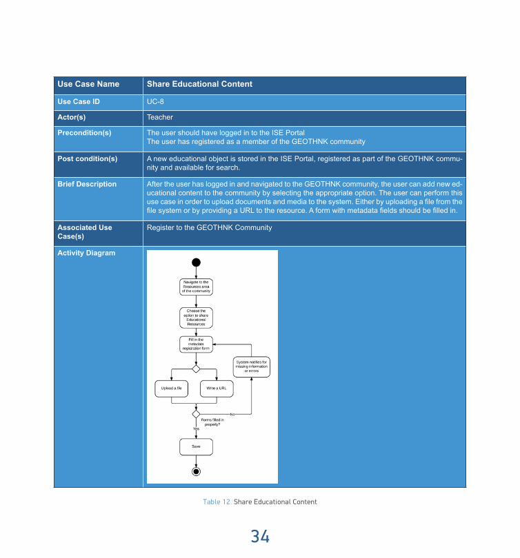
Use Case Name Share Educational Content
Use Case ID UC-8
Actor(s) Teacher
Precondition(s) The user should have logged in to the ISE PortalThe user has registered as a member of the GEOTHNK community
Post condition(s) A new educational object is stored in the ISE Portal, registered as part of the GEOTHNK commu-nity and available for search.
Brief Description After the user has logged in and navigated to the GEOTHNK community, the user can add new ed-ucational content to the community by selecting the appropriate option. The user can perform this use case in order to upload documents and media to the system. Either by uploading a file from the file system or by providing a URL to the resource. A form with metadata fields should be filled in.
Associated Use Case(s)
Register to the GEOTHNK Community
Activity Diagram
Table 12. Share Educational Content

Guide of Good Practice
35
2.5 GEOTHNK Educational Pathway Authoring ToolThe GEOTHNK Educational Pathway Authoring Tool is a web based application aiming to help users de-
velop Educational Pathways applying the Educational Pathway Patterns presented in the previous section of this Guide. Access to the GEOTHNK Community (and its platform within) is provided through the project’s website (Figure 1). By clicking on the GEOTHNK Community tab (Figure 1a) one is directed to the GEOTHNK Community (Figure 2).
Figure 2: GEOTHNK community
Figure 1: GEOTHNK website

36
2.5.1 PrerequisitesBasic familiarity with computers and how to browse the Internet will be adequate for using the GEOTHNK
Educational Pathway Authoring Tool. It is recommended that the resolution of the computer display is ad-justed to 1024x768 or higher.
2.5.2 Entering The GEOTHNK Pathway Authoring ToolIn order to precede either visit the GEOTHNK project’s website (Figure1) and access the Authoring Tool
through the Community tab (Figure 1a) or direct the browser to the following link: www.geothink-portal.eu and afterwards login (Figure 3a) by providing your account credentials, username and password (Figure 3b). In case you do not have an account, please register with the community by selecting the “Join Now!” link (Figure 3c).
Figure 3: Εntering the GEOTHNK Community
Upon joining the GEOTHNK Community the user can navigate to the Community Main Page and select from three available sections: “Tools”, “Resources” and “People” (Figure 4). Section “Tools” includes the existing Tools of the GEOTHNK Community, section “Resources” includes the existing Resources of the GEOTHNK
3a
3c3b

Guide of Good Practice
37
Community and section “People” includes the members of the GEOTHNK Community. “Top Tools” shows the most viewed tools, “Featured Resources” shows the most viewed resources and “Top Members” shows the users with the most contributions to the Community (Figure 5). When the user clicks on “Resources” then this choice will take him/her in the community resources area where he/she can either search for existing educational resources (Figure 6a) or select to create a new one (Figure 6b). In addition when following any of the two options the user can preselect the type of resource that he/she is either looking for or wishes to create (Figure 7).
Figure 4: The GEOTHNK Community Interface Introduction
Figure 5: The GEOTHNK most viewed Resources area

38
Figure 6: The GEOTHNK Resources Page
Figure 7: The “Create New” Resources Page
6a 6b

Guide of Good Practice
39
Figure 8: The GEOTHNK type of Resources Page
Figure 9: The GEOTHNK Pathway Tool Interface
9a
9b

40
There are two types of resources: educational object and learning pathway (Figure 7-8). The user might click on the help balloons next to each choice in order to learn more about each kind of Resource before making his/her selection. Upon selecting the ”Learning Pathway” type of Resource and clicking on the “Create New” option the user automatically enters the Educational Pathway Authoring Tool and could choose what type of pathway he/she wishes to construct, selecting from structured (labelled as “Pre-structured visit”) (Figure 9a) or open (labelled “Open Visit”) (Figure 9b).
Detailed documentation about the difference between structured and open pathways is provided in Section 2 of this Guide. The authoring of both types of Pathways is based on a similar structure and the same inter-face and tools. In the following sections of this Guide the construction of a Structured Pathway is presented.
2.5.3 Creating An Educational PathwayUpon selecting the Structured Pathway type the platform forwards the user to the authoring page. The au-
thoring page consists of:
• The Language boxes: The user should select at least one language. For each language he/she selects, equal number of Content Fields in the corresponding language will appear in the Content Tab (Figure 10). Currently there are 6 languages to choose from: English, German, Romanian, Bulgarian, Greek and Dutch (Figure 10a)
• The Content and Metadata tabs: These tabs indicate at which part of the authoring tool the user is work-ing. In the content area the user creates the Title, Short description and main body of the Educational Scenario while in the Metadata area the user adds the necessary metadata of the Pathway that was created in the previous area (Figure 10b).
• The “Save”, “Save & View” buttons: These buttons serve for saving each Educational Pathway. More specifically, the “Save” button serves for saving the Educational Pathway without further action, the “Save & View” button serves for saving the Educational Pathway and redirecting the user to a new page where he/she can view the summary of his/her Educational Pathway. Finally, there is the “Save as” but-ton which is used only when a user wants re-use an already existing pathway (more information can be found below). These buttons are related to the “Status” drop-down menu (Figure 10c).
• The “Status” drop down menu: This feature is used in order to identify a Pathway as a draft or final. The unfinished Pathway can be retrieved later for completion. Once the user saves the Pathway as draft, the draft Pathway can be accessed later on section as it will appear in the account page of the user (Figure 10d).
• “Portrait” of each Educational Pathway: The Portrait of your Educational Pathway: Here, the user can upload a picture that would accompany his/her Educational Pathway, serving as its identity (Figure 10e).
• The main authoring pane of the phase: In this pane the user will be able to provide input for each of the available activities of each phase (Figure 10f).

Guide of Good Practice
41
• The “Back to the community” Button: The “Back to the Community” link directs the user to the starting page of the GEOTHNK Community, ignoring any information provided to the tool so far (Figure 10g).
• The phase’s navigation pane: Within the main authoring pane one can find the navigation breadcrumb appearing in the form of tabs. The breadcrumb is a navigation aid that helps the user to keep track of his/hers location within the different phases of the Educational Pathway. The breadcrumb appears in the Content section of the page. The navigation between the different phases (pre-visit, visit, post-visit) can be done by the tabs appearing in the breadcrumb. This feature is being presented in the next sec-tion (Figure 9a).
Figure 10: The GEOTHNK Pathway Authoring Pane
2.5.4 Authoring PaneThe authoring pane is the section where the activities of each Pathway phase are inserted by the user. Both
“Structured” and “Open” Pathways consist of three phases:
• Pre-visit • Visit • Post-visit
Each phase contains a series of activities, which the user completes in order to create the Pathway. The “Eratosthenes Experiment” activity pane is presented in the sections that follow in order to illustrate how a real learning pathway appears on the GEOTHNK platform. This activity for the Pre-visit phase of a Structured Pathway is presented in Figure 9. Visit and Post-visit phases follow a similar design to the Pre-visit phase and
10a
10b
10c
10d
10e
10g
10f

42
will be presented in section 3.4.6 of this Guide.
Figure 11: Pre-visit Phase Authoring Pane
Each activity consists of four fields:
• Title of the Activity: The title for each activity of the respective phase (Figure 11b).
• Guidelines for each activity: A short text describing the actions the user has to perform for the specific activity. In order to activate the instructions the user has to click on the green button next to the sub-activity (Figure 11c).
• Description: In this field the user describes what the actual actions should be for the specific activity. To accomplish this, the user can insert in the provided box area the input he/she wishes, including text, photos, links, videos and other options that can be styled and formatted with the help of the special edi-tor that accompanies each box area (Figure 11d).
• Attaching additional info and/or Learning Objects: In this field the user can associate various digital learning resources to the specific activity via the “Attach” button (Figure 11e). In each sub-activity of every educational phase the user has the following options (Figure 12):
1. Correlate his learning pathway to specific geo-concepts
2. Instantiate these geo-concepts with geo-instances (where applicable).
11a
11e
11b
11d
11c

Guide of Good Practice
43
3. Add representation and reasoning tools that can be used in this activity
4. Search for and attach educational objects that are either defined by the specific user within the commu-nity or by other users either within the GEOTHNK community or in the parent community of GEOTHNK, i.e. the ISE community.
5. Upload various kinds of files (.pdf,.kml,.png,.jpg,.rar,.zip, shape files (.shp,.shx,.dbf,.sbn))
6. Add external links.
A detailed description for the aforementioned options offered to the user is provided in paragraphs 3.4.1 to 3.4.5 of this Guide.
Figure 12: Attaching resources to GEOTHNK sub-activities
2.5.5 Geo-concepts and Geo-instancesThrough this feature the user can select to link the educational pathway to geo-concepts by selecting the
nodes in the graph or the elements in the taxonomic view. In order for the user to be able to see the taxonomic view, he has to click the “Show graph” button (Figure 12a). When he clicks on it, the window of the Semantic Network of geo-concepts appears (Figure 13-15). It consists of three panes:
1. 1. The first pane on the left includes the Semantic Network in a Treeview Structure. The user can either navigate through the Tree of geo-concepts or type in the keyword search field in order to easily find the
12a
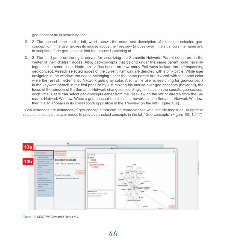
44
geo-concept he is searching for.
2. 2. The second pane on the left, which shows the name and description of either the selected geo-concept, or, if the user moves its mouse above the Treeview (mouse-over), then it shows the name and description of the geo-concept that the mouse is pointing at.
3. 3. The third pane on the right, serves for visualizing the Semantic Network. Parent nodes are in the center of their children nodes. Also, geo-concepts that belong under the same parent node have al-together the same color. Node size varies based on how many Pathways include the corresponding geo-concept. Already selected nodes of the current Pathway are denoted with a pink circle. While user navigates in the window, the nodes belonging under the same parent are colored with the same color while the rest of theSemantic Network gets gray color. Also, while user is searching for geo-concepts in the keyword search in the first pane or by just moving his mouse over geo-concepts (hovering), the focus of the window of theSemantic Network changes accordingly, to focus on the specific geo-concept each time. Users can select geo-concepts either from the Treeview on the left or directly from the Se-mantic Network Window. When a geo-concept is selected or hovered in the Semantic Network Window, then it also appears in its corresponding position in the Treeview on the left (Figure 13a).
Geo-instances are instances of geo-concepts that can be characterized with latitude-longitude. In order to select an instance the user needs to previously select concepts in the tab “Geo-concepts” (Figure 13b,16-17).
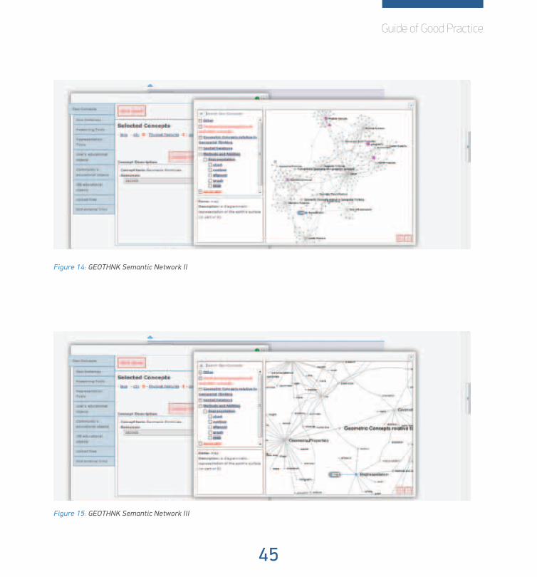
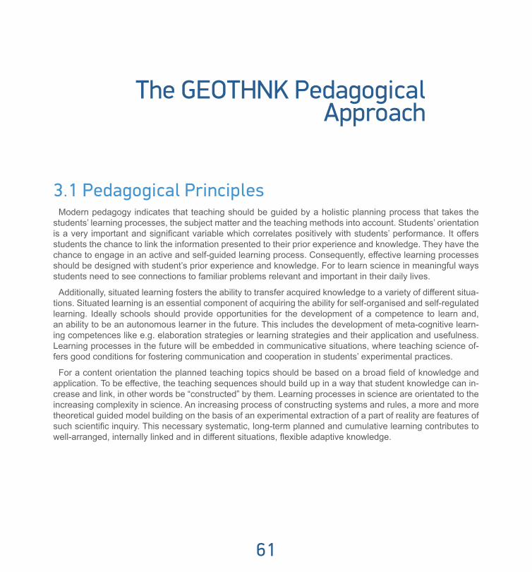
Figure 13: GEOTHNK Semantic Network I
13a
13b
Guide of Good Practice
45
Figure 14: GEOTHNK Semantic Network II
Figure 15: GEOTHNK Semantic Network III

46
Figure 16: GEOTHNK Adding Geo-Instances I Figure 17: GEOTHNK Adding Geo-Instances II
2.5.6 Reasoning ToolsReasoning tools provoke critical thinking about geospatial entities, phenomena, and events that occur in
space, as well as their relations and interactions. Examples of this kind of tools are educational games, geo-graphic information systems, map making and other interactive applications. For each reasoning tool the user is able to upload a screen shot of the tool to illustrate his/her activity with the use of the tool (Figure 18-19). More specifically, following the corresponding figure, the user can upload the screenshot he wishes, by click-ing on “Browse...” and select the suitable picture from his computer. Then, she/he should add in the “Source” field the source where he found this picture (by adding free text). Finally, she/he should click the “Upload” button, in order to finalize his selection of picture. Then, she/he should click on the “Confirm Selection” button, in order to finalize his selection of tools.
Figure 18: GEOTHNK Adding Reasoning Tools I Figure 19: GEOTHNK Adding Reasoning Tools II

Guide of Good Practice
47
2.5.7 Representation ToolsRepresentation tools illustrate and communicate the structure and function of geospatial entities and their
relations, such as maps, atlases, satellite images, globes, 3D views, diagrams, charts, etc. For each rep-resentation tool you the user is able to upload a screen shot of the tool to illustrate his/her activity with the use of the tool (Figure 20-21). More specifically, following the corresponding figure, the user can upload the screenshot he wishes, by clicking on “Browse...” and select the suitable picture from his computer. Then, she/he should add in the “Source” field the source where he found this picture (by adding free text). Finally, she/he should click the “Upload” button, in order to finalize his selection of picture. Then, she/he should click on the “Confirm Selection” button, in order to finalize his selection of tools.
Figure 20: GEOTHNK Adding Representation Tools I Figure 21: GEOTHNK Adding Representation Tools II
2.5.8 Attaching Educational ObjectsEducational Objects are typically digital materials such as video and audio lectures (podcasts), references
and readings, workbooks and textbooks, as well as multimedia animations. There are three types of educa-tional objects that can be added:
a) User’s educational objects
In this tab the user search the educational objects that he has shared to the community. This includes ob-jects from the user’s collected object list. The search can be applied on the title or keywords of the object and can be also performed through the drop down menu provided to the user (Figure 22a).
b) Community’s educational objects.

48
In this tab the user can search the educational objects from the community. The search can be applied on the title or keywords of the object as well as through the drop down menu provided to the user (Figure 22b).
c) ISE educational objects
In this tab the user can search the educational objects from the ISE (Inspiring Science Education).
2.5.9 Upload files and add external linksIn order to add external digital resources the user has to browse in his computer and click the “Upload” but-
ton under the “Upload files” section. The user then will be prompted to select the desired file and click “Open”. Automatically then the file starts uploading in the portal. Αfter the file is uploaded the user must finalize the upload by clicking the “Confirm Selection” button (Figure 23a). The authoring tool supports the upload of a variety of files (.pdf,.png,.jpg,.rar,.zip,.kml, shape files (.shp,.shx,.dbf,.sbn))
Moreover, the user by clicking the “Add external links” button can create an area where useful links can be added to the learning pathway (Figure 23b).
Figure 22: Attaching Educational Objects Figure 23: Uploading files and adding external links
2.5.10 Authoring the Visit and Post-visit phasesThe authoring and editing of the consequent two phases of a Pathway, ‘Visit’ (Figure 24-25) and ‘Post-visit’
(Figure 26-27), can be done in the same way as described in the previous sections for the ‘Pre-visit’ phase.
23a
22a
22b
22c

Guide of Good Practice
49
Figure 24: Visit phase Authoring Pane I Figure 25: Visit phase Authoring Pane II
Figure 26: Post-Visit phase Authoring Pane I Figure 27: Post-Visit phase Authoring Pane II
2.5.11 Finalizing the Pathway with MetadataDuring the completion of the different phases, the user can temporally save the work that has been done by
using the “Draft status” functionality. The user can retrieve the draft Pathway and continue authoring by visit-ing his account page and selecting the draft Pathway that wishes to amend.
To finalize a Structured Pathway the user must complete all phases and activities in the Content area and

50
also proceed to add all necessary information (some is mandatory) in the Metadata area. Users should always bear in mind that in order to finalize an Educational Pathway, they should select AT LEAST one geo-concept and one tool (either reasoning or representation one).
Figure 28: Metadata Mandatory Area I Figure 29: Metadata Mandatory Area II
In the “Mandatory” section the following metadata has to be added:
Author’s background, Keywords, Subject domain, Context (selection of: informal context, primary education, secondary education), Age Range and Target audience (selection of: Content Providers, Parents, Teachers, Technology Developers) (Figure 28a). The “Recommended” section provides metadata on: Author (name), Ob-jectives (a list of objectives is provided to the user from which he/she can select the most suitable objectives), Prerequisites, Linear of difficulty (select form five levels: difficult, easy, medium, very difficult, very easy) and Time required (to complete the activity) (Figure 29-30).
Figure 30: metadata Recommended Area II
28a
28b
28c

Guide of Good Practice
51
Once all phases in the Content area are completed the user is required to move to the Metadata section in order to add metadata to the learning pathway. This section is divided by tabs in three subareas based on the degree of classification of information: Mandatory, Recommended and Optional (Figure 28).
The last section characterized as “Optional” includes metadata on:
Assessment Strategy, Learning Environment, Special Needs, Teaching Approach, Technical Requirements, Coverage, Structure (selection of: atomic, collection, hierarchical, linear, networked), Rights Cost (where either a payment is required or the activity is offered for free), Copyright and Other Restrictions, and Right Description (Figure 31-32).
In this authoring pane the user can preview the Educational Pathway developed and publish it. By clicking the Save and View button the user will be able to view the Educational Pathway. There the user is able to see all the information and the digital resources used for the specific Pathway. If the educational Pathway is not ready, the user is able to move back to the previous phases by clicking the browser’s back button and correct the corresponding activities.
Figure 31: Metadata Optional Area I Figure 32: Metadata Optional Area II
If the Pathway is considered as final and the user wants to publish it in the GEOTHNK Portal, the following actions must take place:
• Complete the Metadata of the activity (Figure 28).
• Click on the “Save” tab to save your Pathway (Figure 28b) in the GEOTHNK Repository or on the “Save and View” tab to save the Pathway and also view it (Figure 28c).

52
2.5.12 Viewing the Educational PathwayAfter the completion of the Content and Metadata sections, the learning pathway can be saved and viewed
(Figure 33-39).
The user can view 7 different tabs in this section:
1. Description: It includes the title, author and short description of the Educational Pathway.
2. Information: This tab includes the various meta-data associated with this Pathway.
3-5: Pre-visit/Visit/Post-visit tabs: They present the information added in each one of these tabs.
6: Geo-concepts: It presents the Semantic Net-work and highlights with colour the selected geo-concepts and the shortest path among them.
7: Geo-instances: It shows the “map” of the Path-way, i.e. the geo-instances that have been select-ed to instantiate the corresponding geo-concepts of the given Pathway. Moreover, the user can download the Pathway in a PDF file, edit or delete it (if it is his/hers) and finally re-use it, if the author provides this possibility. (Figure 33a)
Figure 34: Viewing the Learning Pathway: Information
33a
Figure 33: Viewing the Learning Pathway: Description

Guide of Good Practice
53
Figure 35: Viewing the Learning Pathway: Pre-Visit
Figure 36: Viewing the Learning Pathway: Post-Visit

54
Figure 37: Viewing the Learning Pathway: Geo concepts
Figure 38: Viewing the Learning Pathway: Geo instances

Guide of Good Practice
55
2.6 Search Educational resources of the CommunityApart from creating new educational resources in the GEOTHNK Community, the users can also browse
and retrieve the already existing ones, by clicking on the button “Search educational resources of the Com-munity”.
There are three different ways for browsing the GEOTHNK 4. Community:
• Keyword Search
• Map Search
• Graphs Search
Figure 39: Search for educational resources
2.6.1 Keyword searchIn this tab, users can search for educational resources. There are many search filters for the users to select
from. They can select one or more filters during their search, regarding what they wish to find.
“Keyword”:
Users can search for educational resources via a keyword. Keyword search searches for the inserted word both in the Title and Short description of each educational resource.

56
“Resource Type”:
Users can limit their search either among Educational Objects or among Educational Pathways.
“Geo-concepts”:
Users can select specific Geo-concepts from the Semantic Network, provided in the drop-down menu.
Search will return back all Educational Pathways that are associated with these Geo-concepts.
“Geo-instances”:
Users can select specific Geo-instances from the already existing ones, provided in the drop-down menu.
Search will return back all Educational Pathways that are associated with these Geo-instances.
“Discipline”:
Users can search for Educational Pathways that are associated with the corresponding Discipline, e.g. Sci-ence, Physics, Geography, etc.
“Language”:
Users can select in which language they wish to search for Educational Pathways and the search will return back only the Educational Pathways available in this language.
“Educational Context”:
Users can search Educational Pathways per Educational Object, i.e. Primary Education, Secondary Educa-tion, etc.
“Target Audience”:
Users can search Educational Pathways per Target Audience, i.e. Adult Learners, University Students, etc.
“Exemplary Scenario”:
This search filter returns only the exemplary Educational Pathways available in the GEOTHNK Community. Users can also sort the search results alphabetically, as well as based on which is most popular or more recent.
2.6.2 Map SearchThis section includes a map which contains all Geo-instances defined by the users and associated with the
various Educational Pathways visualized like pins on the World Map. Users can search for Educational Path-ways, either via the pins on the map or via the keyword search, by typing the place in the Earth (city, country, lake, etc.) that he wishes to search for. If the Geo-instance exists, already associated with a pathway, the corresponding Educational Pathways are being returned. If not, search returns no pathways.

Guide of Good Practice
57
Figure 40: GEOTHNK Map Search
2.6.3 Graph SearchThis section includes the Graph Window already presented in the creation of an Educational Pathway. Us-
ers can search for Geo-concepts in the Semantic Network, either via the window on the right, by clicking on the Geo-concepts or via the keyword search on the left, by typing the name of the geo-concept he wishes to search for. A user can search for one or more geo-concepts. If there are existing Educational Pathways as-

58
sociated with the geo-concepts inserted, then the corresponding Educational Pathways are being returned. If not, search returns no pathways.
Figure 41: GEOTHNK Graph Search (από το Manual)

Guide of Good Practice
59
2.7 ReferencesKruchten, P. (n.d.). The Software Architect. Software Architecture, 565-583.

3The GEOTHNK Pedagogical Approach
61
The GEOTHNK Pedagogical Approach
3.1 Pedagogical PrinciplesModern pedagogy indicates that teaching should be guided by a holistic planning process that takes the
students’ learning processes, the subject matter and the teaching methods into account. Students’ orientation is a very important and significant variable which correlates positively with students’ performance. It offers students the chance to link the information presented to their prior experience and knowledge. They have the chance to engage in an active and self-guided learning process. Consequently, effective learning processes should be designed with student’s prior experience and knowledge. For to learn science in meaningful ways students need to see connections to familiar problems relevant and important in their daily lives.
Additionally, situated learning fosters the ability to transfer acquired knowledge to a variety of different situa-tions. Situated learning is an essential component of acquiring the ability for self-organised and self-regulated learning. Ideally schools should provide opportunities for the development of a competence to learn and, an ability to be an autonomous learner in the future. This includes the development of meta-cognitive learn-ing competences like e.g. elaboration strategies or learning strategies and their application and usefulness. Learning processes in the future will be embedded in communicative situations, where teaching science of-fers good conditions for fostering communication and cooperation in students’ experimental practices.
For a content orientation the planned teaching topics should be based on a broad field of knowledge and application. To be effective, the teaching sequences should build up in a way that student knowledge can in-crease and link, in other words be “constructed” by them. Learning processes in science are orientated to the increasing complexity in science. An increasing process of constructing systems and rules, a more and more theoretical guided model building on the basis of an experimental extraction of a part of reality are features of such scientific inquiry. This necessary systematic, long-term planned and cumulative learning contributes to well-arranged, internally linked and in different situations, flexible adaptive knowledge.

62
3.2 Bridging the gap between formal and informal learning
The most extensively taught science subjects in the countries of the European Union are Biology, Phys-ics, Chemistry and Technology, which are all offered as monodisciplinary subjects. On the contrary, subjects characterized by an interdisciplinary approach like Natural Sciences, Earth Sciences or Health Education-Hygiene are only offered in a low number of countries. The curricular subjects are characterized by great variation in the secondary level of most countries. As far as the curricular resources used in the science and technology based subjects it can be noted that the most widely used resources are textbooks (either officially prescribed or commercially offered); libraries’ resources and school laboratories. It is worrying however, that ICT are rather rarely used as teaching resources for science subjects. Additionally while the vast majority of students hold positive attitudes towards S&T at the early schooling stages (70-80% of the 4th graders in all countries), this situation is considerably moderated at the later stages (8th Grade). Our educational systems have to shift from the traditional paradigm of teacher-directed learning and the dissemination of knowledge, to learner-centred curricula that promote the development of lifelong learners who can think critically, solve problems and work collaboratively. During the last centuries a considerable number of pedagogues and edu-cational practitioners (e.g. Comenius, Pestalozzi, Montessori and Dewey) have stressed the importance of visualisation and of hands-on experiences as vital components to the learning process. As a result of these perspectives, may different pedagogical methods have been developed, especially those to be used in lower grades at elementary schools.
At the same time, science centres are no longer isolated hands-on workshops created by a couple of ‘sci-ence freaks’, but have become part of a larger movement promoting public understanding of science. The unique strength of museums is that they can provide schools with the real world context and the exploratory experiences that constructivists are advocating. With such an idea in mind, Gardner (1991a, 1991b, 1992) has brought a powerful message of educational reform to practitioners within the respective fields of educa-tion and museum education. In this message, he challenges schools and museums to combine the evoca-tive learning that takes place within experience oriented museums with the rigor and structure of a cognitive apprenticeship. Museum educational reform has pushed museums to give education a higher priority, by incorporating it into their mission statements and into every organisational activity. Such a goal requires the redefinition of museum-school collaboration.

Guide of Good Practice
63
The GEOTHNK approach builds on the strengths of the informal learning taking place in science centers and museums, to involve school students, their teachers as well as all lifelong learners in inspiring learning activi-ties – in close relation and interplay with the school curriculum, if that is of interest to the user of the content. The outcome is the proposition of an innovative learning approach that not only crosscuts the boundaries between formal (schools, universities) and informal (science centers) learning settings but also recognizes the diversity of personal learning styles and behaviors in different contexts and applications (e.g. various GEOTHNK scenarios can be developed around the same educational object for different learners based on their scientific background). The GEOTHNK pedagogical framework is based on two main pedagogical ap-proaches, The Contextualized Model of Learning that represents the potential of informal education, the In-quiry Based and Problem Based approaches that are currently considered the most appropriate approaches for the reform of formal science education.
3.3 Inquiry Based LearningInquiry-based learning is applicable at all levels of formal education, from infant schools to universities, and
takes place in informal as well as formal learning contexts. In this introductory section, we highlight generic features of this approach to learning and teaching, as background context for the subsequent specific focus on Inquiry Based Science Education (IBSE) in school-level science learning. Students conduct inquiries that enable them to engage actively with questions and problems associated with their subject or discipline. Stu-dents use the inquiry methods and practices of the subject to construct and share knowledge. Inquiry learning is an empowering approach with benefits for subject learning as well as a wide range of important high-order

64
intellectual attributes. Successful inquiry learning flows from purposeful engagement with inquiry questions and tasks, in a challenging and supportive learning environment.
Inquiry learning can be applied flexibly across different educational contexts, across all academic disci-plines. There is no single design protocol and teaching strategies vary. However, the fundamental point of departure is always an authentic question or problem that may be formulated by students themselves, their teachers, or others. Tasks designed to provide a framework for inquiry include problem or case scenarios, field-work investigations, experiential learning projects and laboratory experiments as well as research proj-ects of various kinds. Students’ inquiries may be small or large in scale, involving ‘whole-cycle’ research proj-ects or only specific elements of a larger research process. Often working collaboratively or cooperatively with peers, sometimes in partnership with teachers, students are supported by teachers and others with specialist educational roles (e.g. librarians, learning technologists, or museum educators) to apply the scholarly and research techniques of their academic or professional discipline. Inquiry learning often involves the use of digital resources and tools and may be carried out face-to-face, on-line or in a blended combination of these. Inquiry processes may be highly structured or more flexible, some giving students a large degree of control in the framing and direction of their inquiries and others being more strongly teacher directed. Not uncommonly, students become involved in self- and peer-assessment of their inquiries, and engage in critical reflection on the process they have experienced. They may be encouraged to share the results of their inquiries with each other and with wider audience.
Inquiry-Based Science Education is a problem-based approach but goes beyond it with the importance given to the experimental approach. Thus, inquiry learning can be identified as the broader and more flexible concept of the two and PBL as a subset of inquiry learning. In the case of GEOTHNK inquiry base learning can be adopted both in terms of activities in classrooms and in technology-supported learning environments such as science centres and or museums.
3.4 Essential features of inquiry in learning environments with the integration and use of technology
Establishing inquiry-based learning environment
Establishing inquiry-based learning environments with the integration and use of technology seems to be a pervasive theme in science education and debates about its importance appear through several arguments in the literature. Overall however, two general reasons have been described for the use of computer tools for in-quiry. First, computer tools help students to focus on higher learning processes being characteristic of inquiry, such as planning investigations or constructing knowledge, by assuming large parts of routine processes, like calculating, acquiring, sorting, or visualising data, retrieving and saving information. Second, they promote students’ self-regulated learning with all its positive effects on motivation, as students can access information and hints via the interface on their own pace and do not rely on the teacher.

Guide of Good Practice
65
Computer-based inquiry learning environments may help students to combine scientific content knowledge and inquiry processes in a way that may not be feasible in classroom-based inquiry; they may allow learners to engage in genuine inquiry tasks and thereby learn the domain together with learning scientific inquiry pro-cesses, in an environment that scaffolds them. Computer-based tools may support students in learning how to pose questions, how to gather, analyze real data and develop models, using processes already applied by scientists like calculating, retrieving, accessing and sorting information. Increasingly, students are starting to use the same tools and resources that are used by scientists.
Data analysis and processes can be controlled by students via an interface, and in some instances assess-ment can be provided by the system itself. In general terms, technology can help make a learning environ-ment more learners’ centred by providing a greater variety of resources that allows students to follow their own interests and build upon their strengths. It can also help teachers motivate students to work toward deep understanding or transfer by illustrating how what is under study in the classroom relates to the world beyond it such as by accessing real-time data on current events. Finally, technology can help teachers meet students’ differentiated needs, by serving as a tool for enrichment or review, or for presenting information in additional formats; and by providing additional opportunities for feedback within and outside the classroom.
All of the fundamental properties of computing technologies offer benefits for inquiry-based learning—the ability to store and manipulate large quantities of information, the ability to present and permit interaction with information in a variety of visual and audio formats, the ability to perform complex computations, the support for communication and expression, and the ability to respond rapidly and individually to users. With regard to the inquiry process in particular, a variety of promising technologies have been developed for learn-ers, including tools for modeling phenomena and processes from the real world, visualizing and analyzing quantitative data, exchanging data and ideas across distances, structuring and supporting and providing ac-cess to information in the form of digital collections or libraries. In the GEOTHNK approach to inquiry-based learning, computer technologies and our online platform are used to provide representation and reasoning tools, knowledge resources (for formal and informal educational environments), and strengthen the creation of educators’ communities around a topic, a tool or even a specific learning pathway.

66
3.5 GEOTHNK Educational PathwaysAn Educational Pathway in the GEOTHNK describes the organization and coordination of various individual
science learning resources into a coherent plan so that they become a meaningful science learning activity for a specific user group (e.g. teachers, students, other museum visitors, etc.) in a specific context of use. Fur-ther, Educational Pathways directly serve the priority assigned by GEOTHNK to the integration of resources scattered in various science museums/centres into the same learning experience rather than the mere se-lection of resources from a single museum or science centre. It should be kept in mind that an GEOTHNK Educational Pathway may include only the use of digital content at a distance, without physically visiting the

Guide of Good Practice
67
science museum or centre (‘virtual visit’), or a combination of using digital content (at a distance or onsite) with a physical visit to the science museum or centre (‘physical visit’). In practical terms, it is proposed that teacher and learner activity be described in the Educational Pathways as an iterative process consisting of five phases:
• Question Eliciting Activities
• Active Investigation
• Creation
• Discussion
• Reflection
3.6 GEOTHNK Pedagogical PatternThe GEOSTHNK Educational Pathways have been following specific pedagogical patterns as it is shown
below:
3.6.1 The Educational Pathway Pattern for a Pre-Structured Visit by the School
A) Introductory section and preparatory phase
The following basic information about the intended learning experience is to be defined at the outset. This information should allow the teacher to assess the relevance of the resource to his/her teaching needs and particular circumstances, and provide him with guidance for the preparation of the learning experience. Note that most of this information can be directly linked to specific elements of the GEOTHNK Application Profile. The formalisation proposed there for certain elements is to be applied accordingly in this introductory section too.
Title:
Give a title that helps easily recognize the content focus and purpose of the Educational Pathway.
Short description:
A description of no more than 30 words outlining the scope of the Educational pathway, descriptive enough to help the user in the first instance to estimate its possible relevance to her/his interests.

68
Keywords:
A limited number of words/short phases reflecting the topic and scope.
Target audience:
The intended end user: teacher with students, teacher, students, other…
Age range:
Up to 6, 6-9, 9-12, 12-15, 15-18…
Context:
The places that the Educational Pathway involves: school, science museum/centre, independently on the web.
Time required:
The approximate time typically needed to realize the Educational pathway. This could be distinguished into the amount of time required for school-based work and science museum/centre-based work.
Technical requirements:
Description of any special technologies, infrastructure and/or technical expertise required for the realization of the Educational Pathway.
Author’s background:
What was the main function of the person who prepared the Educational Pathway: school teacher; museum educator; parent; other.
Connection with the curriculum:
Reference to the items of the science learning vocabulary mainly covered by the Educational Pathway, and prerequisite knowledge
Learning objectives:
Short description of the objectives of the described science learning experience
Guidance for preparation:
Guidance provided by the creator of the Pathway about any necessary arrangements that will need to be made by the interested teacher before launching the activities described in the following sections.

Guide of Good Practice
69
B) Pre-visit
Teaching Phase 1: Question Eliciting Activities
• Provoke curiosity:
Describe ways and materials (resources already available in the GEOTHNK repository or other) that the teacher will present to the students in the classroom to attract their attention to the targeted subject matter. Make sure they are easily available to the interested user in the GEOTHNK repository, and give directions for finding them. Possibly and if appropriate, integrate them into one practical resource in the appropriate format (e.g. a slides presentation).
• Define questions from current knowledge:
Formulate the scientifically oriented questions that the teacher will present to the students to provoke their engagement in thinking about the target subject matter based on their existing knowledge. Make these questions digitally available and easily usable, e.g. by integrating them in the materials described in the previous step.
Teaching Phase 2: Active Investigation
Note: This is a transitional phase on the borderline between the Pre-visit and Visit sections of the Educational Pathway. ‘Active Investigation’, and in particular the step of ‘Planning and conducting simple investigation’ can take place either before or during the ‘visit’, or both, depending on whether the teacher decides to use GEOTHNK resources of an ‘exhibit nature’ (exhibits, simulations, experiments, etc.) at this stage (on the web or during a physical visit to a science museum/centre). However the use of physical observation is concen-trated mainly in the next Teaching Phase, under the ‘Visit’ section of the Educational Pathway.
• Propose preliminary explanations or hypotheses:
Describe ways in which the teacher can encourage students to propose possible explanations to the questions that emerged from the previous activity. The teacher should be guided here to identify possible misconceptions in students’ thinking. If applicable, locate or make relevant assistance materials available in the GEOTHNK repository, and give directions for finding them. If appropriate, you may consider inte-grating them in the materials described in the previous steps (e.g. a slides presentation).
• Plan and conduct simple investigation:
Describe ways and materials (resources already available in the GEOTHNK repository or other) that the teacher can use to facilitate the students to focus on evidence as a source of answers to scientific questions. This is the phase in which students are being prepared for the subsequent phase of evidence gathering during observation. Locate or make relevant assistance materials available in the GEOTHNK repository, and give directions for finding them. If appropriate and relevant, it is possible to guide the teacher to use GEOTHNK resources of an ‘exhibit nature’ (exhibits, simulations, experiments, etc.) at this stage – in which case this activity should be moved to the ‘Visit’ section of the Educational Pathway.

70
However it should be noted that the use of physical observation is concentrated mainly in the next Teach-ing Phase of ‘Creation’, under the ‘Visit’ section of the Educational Pathway.
B) Visit
(Teaching Phase 2: Active Investigation)
Note: ‘Active Investigation’, and in particular the step of ‘Planning and conducting simple investigation’ can take place in either the Pre-Visit or the Visit phase of the experience, or in both, depending on whether the teacher decides to use GEOTHNK resources of an ‘exhibit nature’ (exhibits, simulations, experiments, etc.) at this stage (on the web or during a physical visit to a science museum/centre). However the use of observation for gathering evidence is concentrated mainly in the Teaching Phase of ‘Creation’ described below.
Teaching Phase 3: Creation
• Gather evidence from observation:
This is the core element of the ‘Visit’ phase, and can be realized either in the school classroom/lab, by remotely using science learning resources made available by the science museums/centres on the web, or during a physical visit which will involve the use of digital resources. Locate the appropriate resource in the GEOTHNK repository. Explain its use to the teacher, and provide access to any accompanying user support materials. The selected resource (e.g. a simulation, an experiment, an animation, a graph or other exhibit of similar nature) must provide students with an opportunity to collect evidence addressing the scientific questions posed in the previous stages through direct or indirect observation phenomena of the natural world. Provide guidance to the teacher organize and manage the activity most effectively and efficiently. It is recommended to introduce at this stage group work. Guide the teacher to divide students in groups, each of which will be facilitated by the teacher to formulate and evaluate explanations to the scientific questions based on the collected evidence. If applicable, locate or make relevant assistance materials available in the GEOTHNK repository, and give directions for finding them.
Teaching Phase 4: Discussion
Note: This is a transitional phase on the borderline between the Visit and the Post-visit sections of the Edu-cational Pathway. ‘Discussion’ can take place either during or after the ‘visit’, or both, depending on whether the teacher considers that the use of the digital ‘exhibits’ is necessary (or feasible) at this stage. Ideally, ‘Discussion’, and particularly the step of ‘Explanation based on evidence’, should take place in front of the ‘exhibit’, to reinforce the link between the physical experience of using the resource and the mental process-ing of the observed information by the students.
• Explanation based on evidence:
Guide the teacher to provide the correct explanation for the researched topic. Describe ways and materi-als (resources already available in the GEOTHNK repository or other) she/he can use to this end, and give directions for finding them. If appropriate, integrate them into one practical resource in the appropri-

Guide of Good Practice
71
ate format (e.g. a slides presentation).
• Consider other explanations:
Guide the teacher to facilitate the student groups to evaluate their own explanations in the light of alter-native explanations, particularly those reflecting scientific understanding. Describe ways and materials (resources already available in the GEOTHNK repository or other) the teacher can use to this end, and give directions for finding them. If appropriate, integrate them into one practical resource in the appropri-ate format (e.g. a slides presentation).
C) Post-visit
(Teaching Phase 4: Discussion)
Note: This is a transitional phase on the borderline between the Visit and the Post-visit sections of the Edu-cational Pathway. Ideally, ‘Discussion’ should take place in front of the ‘exhibit’, to reinforce the link between the physical experience of using the resource and the mental processing of the observed information by the students. However, if necessary or preferred, it can also be organized as a post-visit activity leading into the next phase of ‘Reflection’.
Teaching Phase 5: Reflection
• Communicate explanation:
Guide the teacher to facilitate each student group to reflect on the previous experiences and produce a report with its findings, presenting and justifying its proposed explanations to other groups and the teacher. Make available or direct to materials (resources already available in the GEOTHNK repository, or other) which the teacher can use to help the students familiarize themselves with and become effective in scientific writing.
Follow-up activities and materials
Describe and direct the user to any follow-up activities or materials that can be used to ‘wrap-up’ the main ‘visit’ experience. These could include appropriate learning assessment and/or reminder materials (e.g. quiz-zes, games, other user-friendly tests), hints for further activities, suggestions for other relevant ‘visits’, etc.
Sustainable contact
Describe and direct the user to any existing possibilities for maintaining contact with the digital resource and its provider, or with other users of the same learning experience.

72
3.6.2 The Educational Pathway Pattern for an Open Visit by Lifelong Learners
A) Introductory section and preparatory phase
The following basic information about the intended learning experience is to be defined at the outset. This information should allow the user to assess the relevance of the resource to his/her learning needs, prefer-ences and circumstances, and provide him with guidance for the preparation of the learning experience. Note that most of this information can be directly linked to specific elements of the Application Profile that will be used in the framework of GEOTHNK. The formalisation proposed there for certain elements is to be applied accordingly in this introductory section too.
Title:
Give a title that helps easily recognize the content focus and purpose of the Educational Pathway.
Short description:
A description of no more than 30 words outlining the scope of the Educational Pathway, descriptive enough to help the user in the first instance to estimate its possible relevance to her/his interests.
Keywords:
A limited number of words/short phases reflecting the topic and scope.
Target audience:
The intended end user: independent informal learner, other…
Age range:
Up to 6, 6-9, 9-12, 12-15, 15-18, 18-25, 25+,…
Context:
The places that the Educational Pathway involves: science museum/centre, independently on the web.
Time required:
The approximate time typically needed to realize the Educational Pathway.
Technical requirements:
Description of any special technologies, infrastructure and/or technical expertise required for the realization of the Educational Pathway.
Author’s background:
What was the main function of the person who prepared the Educational Pathway: museum educator; par-ent; school teacher; other…

Guide of Good Practice
73
Science learning elements:
Reference to the items of the science learning vocabulary mainly covered by the Educational Pathway
Learning objectives:
Short description of the objectives of the described science learning experience
Guidance for preparation:
Guidance provided by the creator of the Pathway about any necessary arrangements that will need to be made by the interested user before launching the activities described in the following sections.
B) Pre-visit (optional)
Orientation information
Describe and direct the user to any information available on the context and elements of the learning activ-ity, which may prepare and orient the use before the ‘visit’. Such information may typically be available on the web (e.g. on the museum’s website), but in cases it may also relate to other media, such as TV programmes, printed materials (e.g. museum leaflets) etc.
Building pre-experiences
Describe and direct the user to any information or activities that might exist and which would be a useful pre-experience preceding the main intended ‘visit’. Such content may for example refer to other learning objects on the web, or, in the case of an open pathway addressing children and families, elements of the school cur-riculum which children should have some knowledge of.
Support or guidance available before the visit
Describe and direct the user to any support or guidance mechanism or contact that may exist for the prepa-ration of the ‘visit’.
B) Visit (the minimal core of the learning experience)
Provoke curiosity: questions to ask, things to observe (optional)
Describe in simple terms the questions that the user could ask, or the observation or information he/she could concentrate on, during the ‘visit’ to get the most of the learning potential offered by the experience. Direct the user to any relevant digital resources.
The core experience
Direct the user to the digital resources constituting the core of the ‘visit’ and describe in detail the way in which the ‘visit’ should be conducted, focusing on information that will help the user’s orientation through the

74
resources involved. If appropriate, explain the rationale behind the proposed ordering of the activities, or state and explain the freedom in which the learning experience can be shaped by the user.
Support or guidance available during the visit (optional)
Describe and direct the user to any support or guidance mechanism or contact that may exist to support the ‘visit’ in real time.
Any other relevant information (optional)
Provide any other information that does not fall under the previous categories but is necessary or useful for the effective / efficient realisation of the ‘visit’.
C) Post-visit (optional)
Follow-up activities and materials
Describe and direct the user to any follow-up activities or materials that can be used to ‘wrap-up’ the main ‘visit’ experience. These could include appropriate learning assessment and/or reminder materials (e.g. quiz-zes, games, other user-friendly tests), hints for further activities, suggestions for other relevant ‘visits’, etc.
Sustainable contact
Describe and direct the user to any existing possibilities for maintaining contact with the digital resource and its provider, or with other users of the same learning experience.
3.7 Space, Representation, and ReasoningWhat is Spatial thinking?
There are many ways to conceptualize spatial thinking. The National Research Council stated that to think spatially entails knowing about Space. Different ways of calculating distance, coordinate systems, and the nature of spaces in two and three dimensions. Space can be thought of as absolute location such as latitude-longitude, universal transverse Mercator (UTM), or the British National Grid. Space also includes relative location, the concepts of adjacency, intersections, and regions.
Representation
The relationship among views; orthogonal versus perspective maps; the effect of map projections; and how features can be displayed cartographically as images, points, lines, and polygons.
Reasoning
Different ways of thinking about distances (great circle routes versus straight-line mapped routes), the ability to extrapolate and interpolate, projecting a relationship on a graph into the future, estimating the slope of a

Guide of Good Practice
75
hillside from a contour map, selecting a detour, and so on.
Why is Spatial thinking important?
Spatial thinking is of great importance for success in solving many tasks in everyday life. With the devel-opment of new technologies such as imaging, computer graphics and data visualization visual-spatial skills are becoming essential. Spatial thinking is also strongly employed in many of the arts. (Recently, there has been a movement to add the arts to the STEM category, creating the acronym STEAM.) Architecture, graphic design, computer sciences, biology, physics, chemistry, geology, geography, archaeology and even medicine (consider the spatial reasoning required to understand various ways of mapping the body, such as x-rays and MRIs) all require strong spatial skills.
3.8 The GEOTHNK approach: how do we promote spatial thinking?
In general, GEOTHNK supports learners (students, university students and adult learners) to apply spatial thinking and purposefully address spatial concepts, across all curricular areas and at any developmental lev-el. This approach helps them achieve the interdisciplinary character of fundamental spatial concepts. On the other hand, it will ground the coherence of the curriculum, reveal interrelations among disciplines and apply fundamental reasoning and thinking to everyday life developing problem-solving skills of the target groups. Up to now, disciplines in the curriculum seem as isolated islands bearing no relation to each other and are often taught as a catalogue of irrelevant terms. GEOTHNK will change this view in teaching since it will enable linking of knowledge across disciplines.
That approach has been achieved through various actions as seen below:
a. Consider ways in which content that is already taught as part of the curricula is spatial in nature and thus can promote the role of spatial thinking
b. Implement interventions in teachers’ practice which are effective in inserting geospatial thinking in the curriculum.
c. Develop meaningful activities (GEOTHNK Educational Pathways) to investigate geo-concepts that are not limited to one discipline and promote interdisciplinarity.
d. Increase university students’ interest by presenting innovative educational resources and taking advan-tage of the current technology and visual displays of data
e. Offer a technological platform that will support visits to geopark/ science center/museum and engage learners in exciting activities that will help them exercise their spatial skills.
76
3.9 References
• American Association for the Advancement of Science (AAAS) (1994).
• Benchmarks for Science Literacy. New York: Oxford University Press.
• Bell, T., Urhahne, D, Schanze, S, Ploetzner, R. (2010). Collaborative Inquiry Learning: Models, Tools and Challenges. International Journal of Science Education, 32(3), 349- 377.
• Bereiter, C. (2002). Education and mind in the knowledge age. Mahwah, NJ: Lawrence Erlbaum Associ-ates.
• Berlyne, D. E. (1966). Curiosity and exploration. Science, 153, 25-33 Berson, M.J. (1996). Effectiveness of computer technology in the social studies: A review of the literature. Journal of Research on Comput-ing in Education, 28, 486- 499
• Blumenfeld, P. C., Soloway, E., Marx, R., Krajcik, J. S., Guzdial, M., & Palincsar, A. (1991). Motivating Project-Based Learning: Sustaining the Doing, Supporting the Learning. Educational Psychologist, 26(3 & 4), 369-398
• Bransford, J. D.; Brown, A. L. & Cocking, R. R. (Eds.). (1999). How People Learn: Brain, Mind, Experi-ence, and School. Washington, D.C.: National Academy Press.
• Bybee, R. D., Trowbridge, L.W., Carlson Powell, J. (2008). Teaching Secondary School Science: Strate-gies for Developing Scientific Literacy (9th Edition). ISBN -13: 978-0- 13-230450-4.
• Cedefop, 2012, http://www.cedefop.europa.eu Cognition and Technology Group at Vanderbilt. (1992). The Jasper experiment: An exploration of issues in learning and instructional design. Educational Tech-nology Research & Development, 40, 65-80
• Crawford, B.A. (2000). Embracing the essence of inquiry: New roles for science teachers. Journal of Research in Science Teaching, 37(9), 916-937
• Daniel C. Edelson, Douglas N. Gordin, Roy D. Pea. Addressing the Challenges of Inquiry-Based Learn-ing Through Technology and Curriculum Design. The Journal of the Learning Sciences, 1999, 8(3-4), pp.391-450.
• Driscoll, M. P. (2002). How People Learn (and What Technology Might Have to Do with It). ERIC DIGEST EDO-IR-2002-05 [on-line] available http://www.ericit.org/digests/EDO-IR-2002-05.shtm
• Duffy, T. M., & Cunningham, D. J. (1996). Constructivism: Implications for the design and delivery of instruction. In D. H. Jonassen (Ed.), Handbook of research for educational communications and technol-ogy. New York: Macmillan
• Edelson, D., Gordin, D, and Pea, R. (1999). Addressing the Challenges of InquiryBased Learning through Technology and Curriculum Design. The Journal of the Learning Sciences, 8(3&4), 391-450.
Guide of Good Practice
77
• Ehman, L.E. & Glenn, A.D. (1991). Interactive technology in social studies. In J.P. Shaver (ed.) Hand-book of research on social studies teaching and learning. New York: Macmillan. pp.513 – 522.
• Gardner, T. (1991a). Making schools more like museums. Education Week, 6(6), October 9.
• Gardner T. (1991b). The unschooled mind: How children think and how schools should teach, New York. Gardner T. (1992). Education for understanding during the early years: Excerpts from the Unschooled mind.
• Harris, C. J., & Rooks, D. L. (2010). Managing inquiry - based science: Challenges in enacting complex science instruction in K-8 classrooms. Journal of Science Teacher Education, 21(2), 227-240.
• Hiebert, J., Carpenter, T. P., Fennema, E., Fuson, K., Human, P., Murray, H., Olivier, A., & Wearne, D. (1996). Problem Solving as a Basis for Reform in Curriculum and Instruction: The Case of Mathematics. Educational Researcher, 25(4), 12-21.
• Hofstein, A. and Rosenfeld, S. (1996). Bridging the gap between formal and informal science learning. Studies in Science Education, 28: 87-112.
• Krajcik, J., Mamlok, R. & Hug, B. (2001). Modern content and the enterprise of science: Science educa-tion in the twentieth century. In L. Corno (Ed.), Education across a century: The centennial volume (pp. 205–238). Chicago, IL: National Society for the Study of Education
• Koulaidis, V. (2003). ECSITE Directors’ Forum, Athens 7-8, 2003, Education systems (formal and informal)-Benchmarking the promotion of RTD culture and public understanding of science.
• Lehtinen, E. (2003). Computer-supported collaborative learning: An approach to powerful learning envi-ronments. In E. de Corte, L. Verschaffel, N. Entwistle, and J. van Merrienboer (Eds.), Powerful learning environments: Unravelling basic components and dimensions (pp. 35–53). Oxford: Elsevier Science.
• Levy, P., Little, S, McKinney, P, Nibbs, A, Wood, J. (2010). The Sheffield Companion to Inquiry-Based Learning. Sheffield: Centre for inquiry-based Learning in the Arts and Social Sciences, The University of Sheffield.
• Levy, P. and Petrulis, R. (2011) How do first-year university students experience inquiry and research, and what are the implications for inquiry-based learning? Studies in Higher Education, (p) DOI: 10.1080/03075079.2010.499166
• Linn, M. C., Davis, E. A. & Bell, P. L. (Eds) (2004). Internet environments for science education. Mahwah, NJ: Lawrence Erlbaum Associates
• McCormick B.H., DeFanti T.A., & Brown, M.D. (Eds.). (1987). Visualization in Scientific Computing. Com-puter Graphics, 21(6). National Research Council (NRC). (1996).
• National Science Education Standards. Washington, DC: National Academy Press.
• NASA. (1998). Understanding our changing planet: Earth Science Enterprise 1998 applications fact book. Washington, DC: National Aeronautics and Space Administration.

78
• OECD, 2012, http://www.oecd.org/piaac Osborne, J. & Dillon, J. (2008). Science Education in Europe: Critical Reflections. A report to the Nuffield Foundation. PISA (2000). Knowledge and Skills for Life: First Results from PISA 2000. OECD. ISBN: 9789264196711.
• PISA (2003). Learning for Tomorrow’s World – First Results from PISA 2003. Available online at: http://www.pisa.oecd.org/dataoecd/1/60/34002216.pdf PISA (2006).
• PISA 2006 Science Competencies for Tomorrow’s World: Volume 1. OECD. ISBN: 9789264040007 Riel, M. (September, 2003). Written testimony for the web-based education commission. [on-line] Available http://www.gse.uci.edu/mriel/e-testify/
• Rocard, M., Csermely, P., Jorde, D., Lenzen, D., Walberg-Henriksson H. and Hemmo, V. (2007) Science Education Now: a renewed pedagogy for the future of Europe, European Commission, ISBN – 978-92-79-05659-8.
• Salmi, H. (2001). Public understanding of science: universities and science centres, Management of University Museums. Education and skills. OECD, Paris. 151-161.
• Salmi, H. (2003). ‘Science centres as learning laboratories: experiences of Heureka, the Finnish Science Centre’. International journal of Technology Management, Vol 25, No 5, pp. 460-476.
• Sotiriou, S. & Bogner, F. (2008). Visualising the Invisible: Augmented Reality as an Innovative Science Education Scheme. Advanced Science Letters, Vol 1, 114-122, 2008 STEDE (2002). Science Teachers Education Development Across Europe, 2nd Annual Report
• Tiberghian, A (2008) Technologies, resources and inquiry-based science teaching: A literature review. Mind the Gap project. Deliverable 5.1.
• van Joolingen, W. R., de Jong, T, Lazonder, A.W, Savelsbergh, E, Manlove, S. (2005). Co-Lab: Research and development of an online learning environment for collaborative scientific discovery learning. Com-puters in Human Behavior, 21(4), 671- 688.

Guide of Good Practice
79

Educational Scenarios
4

81
Educational Scenarios
4.1 IntroductionAs seen in the previous Chapter, Inquiry Based Teaching is teaching strategy where teachers facilitate
students-centered learning and research, acting more as a colleague and guide rather than the dispenser of knowledge. The central aim is to develop students’ intellectual autonomy. Adopting his strategy can become a powerful tool for teachers who want to develop students’’ capacity to think for themselves. For teachers who want to adapt situation for individual needs, it is also a good way to understand how a specific student thinks about a particular problem.
In this section, we present the general structure of an educational learning activity template that was used for designing scenarios the needs of GEOTHNK
Figure 4.1: Inquiry-based model for designing learning scenarios

82
4.2 Educational Scenarios
Scenario A
World Market Routes game
Description: This is an educational pathway which aims at highlighting the navigational skills of the students and to develop their understanding of the world. Through a game where they have work in groups in order to design the best routes among different places in Europe they familiarize with distances and with the relation of time and distance. Along, they are learning to apply the knowledge gained by designing their own routes on an interactive map. This educational pathway can be customized to various grades’ needs.
Pre Visit
Provoke curiosity
The teacher starts narrating a story:
I have ordered a month ago a CD with my favourite music from Austria that I found online, but it actually took longer than I thought to arrive. Then, I checked the map and realized why.
The teacher shows to the students the image above and asks them to understand the cause of the delay themselves, which apparently is that the CD had to be shipped from Austria and to follow a specific route as it can be seen on the map.
Thea teacher insists on the issue.
Appropriate questions for discussion are following:
• Have you ever ordered anything online?
• If yes, have you noticed from where it was shipped?
• Did it arrive late?
Define questions from current knowledge
• Have you wondered how more complicated it is to order online than shopping from your neighborhood?
• Do you think that shopping from abroad is a modern habit of todays?
The teacher shows to the students the video The Silk Road: Connecting the ancient world through trade by Shannon Har-ris Castelo, found on Ted Ed.

Guide of Good Practice
83
Through this video students realize that people have man-aged world trade centuries ago. The key difference is that today everything is easier due to tech-nology, e.g. means of transporta-tion, internet, e-mailing.
Propose preliminary explanations or hypotheses
The teacher discusses the difficulties of world trade regardless the assistance of the advanced technology and reminds them how long it took for the CD she/he has ordered to receive it. They discuss on that.
Suggestive questions:
Does the size of the parcel play any role?
• From which countries would you rather order in order to receive your order the soonest possible? Why?
• Students are supposed to name neighboring countries just because we are focusing on distances mainly.
The aim is to make students realize the route one product has to follow in order to arrive at the shipping address (customer’s).
Later, it is crucial for the success of the activity to help students to see the seller’s point of view.
Suggestive questions:
• Do you think that the seller gains from delaying the arrivals? Why? Why not?
• Was there anything that the seller could do so that the CD arrived earlier?

84
• How you think that the seller should be organized in order to serve all her/his clients?
• If you were a seller how would you handle it?
• Serve only some areas?
• Be in contact with the clients daily?
• Introduce an application where thy will be able to track their parcel?
Plan and conduct simple investigation
The teacher introduces to the students their activity.
Now that you have thought of how world trade works you will actually work as an online seller. Through this game you have to design the best routes on an interactive map to ensure that the product will arrive on time.
You have to follow the steps accordingly!
The teacher divides the groups to three (3) or to six (6) groups, as the suggested shipping route are three (3). It is significant for the learning process to include within each team a representative sample of the class.
• ¼ of the members is responsible for getting the route from the factory to the business address
• ¼ of the group is responsible to get the route from the business to the shipping address
• ¼ is responsible to write down the e-mail based on the two routes and the data they are given
• ¼ of the team is responsible to design the route on the interactive map
In the end all member of the group will deal with all tasks, as presented in “Communicate explanation” part.
Gather evidence from observation
Students now get the following material and they start working.
1. World Market Game 1
2. World Market Game 2
3. World Market Game 3

Guide of Good Practice
85
The teacher should be alert in case any group or student needs help.
For this activity it is highly advisable that each group works with at least one computer.
However, the teacher can have printed out the activity in as many copies as the members of each group so that every student can work on the data be herself/himself.
Students follow all three steps and reach the end of the activity.
Explanation based on evidence
The students have gathered all the information they may need in order to write the e-mail to the customer and to design the interactive map.
Apart from the information given to them, they have to search on the web and to use representative tools. At this stage Google maps is suggested to be used.
The teacher has to be alert in order to direct them correctly when necessary.
Consider other explanations
Although the topic discussed is rather straightforward it is essential to listen to students’ different ideas on the issue.
Possible misunderstandings:
• The longest the distance between two spots, the longest it will take for the parcel to arrive
Actually, this is not totally true. Sometimes, it also depends on how remote a place is or how well it is connected by means of transport.
• The arrival date of a parcel is only depending on the distance between the two places.
In this activity we have not referred at all on postage facilities or on country agreements on travelling. Maybe this is a good chance to do so. Please, refer to your country’s situation.
86
Communicate explanation
Students have completed the activity and they can already communicate their results. The e-mail will be read by those who designed the route on the interactive map and it will be explained by those who wrote the e-mail. Last, those who found the route will present their team’s interactive map.
Follow-up activities and materials
Since the main focus of this activity stands on online shopping it is considered as crucial to present a video with advice concerning safety of online shopping.
Scenario B
My Imaginary City
Description: In order to develop spatial thinking to our students, we implemented a scenario that involves two subjects: Romanian Literature and French Language. The GEOTHNK model was very useful for this purpose, as it facilitates the organization of the content on specific steps.
Pre-visit
Question Eliciting Activities
Provoke curiosity
a discussion / debate about cities is launched. The students are asked to describe their favourite city or a city they would like to visit.
Define questions from current knowledge
Asking questions such as “ If you were in a city you are not familiar with what would you like to visit first?”
Visit
Active Investigation
Stating the hypothesis
The students watch the video” A Paros, a velo” , Joe Dasin and identify the means of transport and the tourist attractions from Paris. Using brainstorming, the students will investigate the topic. The question” What should

Guide of Good Practice
87
a city consist of?” will stimulate their mind. The “ hedgehog” technique will interestingly offer a good graphic representation of all the students’ ideas, both in Romanian and French.
The students are organized in three groups and get the task to create their imaginary city. They will give the city a name and will build the city. Each group will be coordinated by a leader and the tasks will be distributed according to each student’s talent and based on a good cooperation.
Creation
Collecting proofs based on observation
The three cities made by students will be presented reflecting each group’s original views on the city. The leader of the group will describe the city in a few sentences both in Romanian and French.
Post-visit
Discussion
Using role- play, each of the imaginary cities will be virtually visited. The visitor will talk to the “guide” of the city asking for directions in order to reach a certain place he/ she wants to visit. They will use the appropriate vocabulary to finish the task. The other teams will draw the map of the city described based on what they hear. Using appropriate vocabulary gives the students the opportunity to practice description at its best.
Follow- up activities
After a week, each team will write a travel diary with impressions on the visited cities and will come up with a flyer in order to promote each city.

88

Guide of Good Practice
89
Scenario C
Time Zones
Description: Time zones are necessary for regulation of modern life in respect to trade, economy, communi-cation and standardisation. In ancient times neighbouring towns had different times and a meeting at a distinct time was not easy to do. Later a kind of synchronisation of the time between distant locations was done e.g. by acoustical signals. Clocks were got more accurate over the time and the need of a standardised zone with the same time was the solution. But the Earth rotates and therefore more than one time zone is more practi-cal. Therefore twenty-four time zones were set up which differing from neighbouring time zones by one hour but for some exceptions.
Pre-Visit
• Question Eliciting Activities
1. Provoke curiosity: Give some historical input about time: neighbouring towns had different times, etc. Show a picture of a wall with several clocks from different cities which show the current local times (e.g. at hotel, stock market). Call a friend one at the other end of your country (in east-west direction), one in America and one in South Africa and ask for their local times.
2. Define questions from current knowledge Plan your travel: We will fly from Austria to Greece and back via UK to Austria. Check your flight times. What do you find?
• Active Investigation
1. Propose preliminary explanations or hypotheses Similar time in north to south direction, but steps in time from east to west: different times for sun rise and sun set?
2. Plan and conduct simple investigation Across your country (in east-west direction) measure the time of sun rise and/or sun set. Investi-gate Earth rotation and the origin of day and night on Earth.
Visit
• Creation
1. Gather evidence from observation Hyperglobe: Time zones

90
http://homepage.univie.ac.at/andreas.riedl/home/hrg_show.html
http://globoccess.at/showroom
See the rotating Earth and observe sun rise and/or sun set at different locations on Earth. When its noon and midnight at this locations. Compare the findings with other locations of your choice.
See the chart of defined time zones of the Earth. Investigate the boundaries of these zones.
• Discussion
1. Explanation based on evidence In order each location on Earth has noon/midnight at nearly the same time you need zones in north to south direction. What is with big countries, like China or Russia? Why there are some exceptions (half hour difference between neighbouring time zones)? Why there are sometimes different boundaries of these zones (no straight lines from north to south)?
2. Consider other explanations
Set up of one “World Time”: advantages/disadvantages?
Post-Visit
• Reflection
1. Communicate explanation
In a presentation and discussion the students should communicate their findings and report their results.
Follow-up activities and materials
The students have to find more information about the time zones and to write down the more significant facts and generate a poster for the school auditorium.
Sustainable contact
Resources are available at the GEOTHNK portal and the National educational portal.
Scenario D
From counting pebbles to the GPS
Description: Travelling through history, from the era of Eratosthenes with the bematists, to Heron of Alexan-dria and his odometer, to the time of the GPS and the online maps, students will comprehend the concept of distance measurement.

Guide of Good Practice
91
Pre-visit
Question Eliciting Activities
Provoke curiosity
Ask the students: How do you believe distances were measured in the ancient time? You can show them this video and draw ideas from the following links to stimulate a discussion.
Links: Ancient Romans, Ancient Greeks, Ancient Egyptians. Explain to them that in ancient times there was not one standard unit of measurement for length. The units used were based on the lengths of human body parts (such as the foot, the inch- width of a grown man’s thumb etc.).
Even the same unit of measurement had different value from place to place. The case of the Ancient Greeks is very interesting and the unit of measurement called “stadion”. This represents the length of a sports stadium of the time. However, different stadiums had different lengths (with differences reaching up to 50m); as a result, the historical accounts on measured distances have some uncertainty depending on the stadion used for the relevant description. The average value of it is 157.7 m (600 Greek feet according to Herodotus). Explain to your students that it took a fairly long time until one standard unit of measurement had been established. Ask the students: What do you believe about the tools the ancients used in order to measure distance? Ask the students if they believe that the estimation of long distances and the creation of maps were easy in ancient times. The early tools used to measure length were simple setups such as the schoinion (a cord of standard length), the halysis (a metallic chain), or the kalamos (measuring rod from reed or wood).
Another technique used by ancient Greeks, was to employ bematists, specialists who were trained to mea-sure distances by counting their steps. Their measurements were very accurate, reaching only ~2% deviation from today’s measurements. Eratosthenes of Cyrene, famous for his experiment which measured the circum-ference of earth had employed bematists to measure accurately the Alexandria-Syene distance, the value of which was crucial to his investigation.
A more sophisticated tool using wheels and gears in order to measure distance was the odometer. Hero of Alexandria in-vented his odometer circa 40 A.D whereas there are historical references by Vitruvius circa 25 BC describing an odometer used to measure distances.
Since the ancient times, the concept of distance measure-ment has evolved. With the use of more sophisticated meth-ods and digital technology the accuracy of the measurements increasingly improved.
Ask the students how they think our lives would be if we were not able to measure distance as accurately as we do now.

92
4.3 Define questions from current knowledge The teacher asks the students to propose methods to measure various distances. Start-
ing from the length of their arm (meter stick), the distance among neighboring desks (tape mea-sure) , the length of their school (laser) , the radius of a pitch (laser) , the distance from their city to their neighboring city (car odometer). They should also make a quick estimate of these distances.
The students are asked to make some easy conversions from meters to cm, mm or km so as to refresh their knowledge.
Now the teacher asks the students how they believe that we can measure an unknown distance (e.g., the distances from a shore to a ship), the distance from earth to a star or the dis-tance between two cities which belong in different continents? (Hint: Nature has provided us with an extraordinary tool: The speed of light. It is constant and varies from medium to me-dium. In vacuo its value is 300.000 km/sec. Therefore if one measures the time between the emission and the reception of a signal, the distance between emitter and receptor can be easily calculated by the well-known kinematic formula : d = c.t –> d =distance, c = speed of light, t = time interval.
Active Investigation
Propose preliminary explanations or hypotheses
The teacher introduces to the students the concepts of triangulation and trilateration. These concepts can be applied to distance measurements, location finding (GPS), earthquake epicenter find-ing, astronomy calculations etc.
On triangulation:
Triangulation is used to determine an unknown distance. In order to find the distance, you need two refer-ence points the distance (baseline) among which is known, as well as the angles that each of this point makes with the unknown point with respect to the baseline. Show the students the following video on triangulation:
https://www.youtube.com/watch?v=Saw1Eg2iZaI
For further comprehension, the teacher can view the following video: https://www.youtube.com/watch?v=Nv_oiLPJOV0 On trilateration:
Trilateration is the method used to find the location of an oject when we its distance from at least three ob-

Guide of Good Practice
93
jects are known. Trilateration is fully employed in the GPS. Show the following videos to the students concern-ing how trilateration and GPS work :
https://www.youtube.com/watch?v=4O3ZVHVFhes
https://www.youtube.com/watch?v=PLjld-edVj8
Plan and conduct simple investigation
In this activity, the students will simulate the function of the GPS.
They will use an interactive map in which they will mark three checkpoints. These will be the positions of the “GPS satellites”. Using the method of trilateration they will try to locate their unknown position on the map.
- The students will be given the time (T) it takes from each satellite to reach their receiver. Using the relation-ship: with c being the speed of light: 299792,458 km/s, they will calculate the distance from each satellite to their location.
- Next they will draw circles, centered on the GPS locations with radii equal to the respective calculated distances. What do they find? Is it an exact spot, or does it have an uncertainty?
- What happens if we use one more satellite? (Actually this is how GPS works. A location must be viewed by at least 4 satellites in order to locate position). The students will examine the results when a fourth satellite is used. The data that will be provided to the students can be given to them online, if the investigation is done on the PC. Otherwise, the material should be printed for the students.
Visit
Creation
Gather evidence from observation
The students are asked to open the GPS Trilateration Investigation folder and follow the guidelines presented there. The teacher will guide the students whenever necessary. It is advisable to divide the students in small groups. In each group, one or more students will be performing the calculations which convert time to distance, others will be using the PC to flag the GPS satellites on the map and others will be drawing the circles used for the trilateration. Finally, the students will be taking screenshots of the final results and saving them.
Discussion
Explanation based on evidence.
Can the students answer why do we use time data which we later convert in meters in order to measure distances with GPS? If the speed of light was not constant, would this method be applicable? The students

94
are asked to estimate how does the accuracy of their location estimation changes with the number of satel-lites employed. They can answer this question by considering the three and the four satellite case. How would they measure the accuracy?
For more advanced students: An idea is to consider the area in which the three GPS cir-cles overlap. Form a circle centered in the mean of the area and expands it until it almost fits the area in question. The radius of this circle can be used as an estimate of the accuracy. It should be emphasized to the students that their activity is based on a 2D model, whereas reality is 3D for GPS functionality.
Consider other explanations.
The teacher discusses with the students possible misconceptions or difficulties they met during their in-vestigation
• The students are encouraged to express their views on how the GPS could be replaced by another method.
• Together with the teacher, students consider the impact of the GPS on civilization. The teacher can use the following resources to stimulate further discussion:
• http://rachelgreenberg.tripod.com/id12.html
• http://www.batteriesinaflash.com/blog/how-gps-technology-has-changed-society/
• Finally, the students together with the teacher consider the historical development of distance measure-ment and location finding and draw conclusions on the evolution of human understanding of the world around them.
Post-visit
Reflection post
Communicate explanation
The students prepare a short report on the activity they made. Each team will do its own report which will be delivered to the teacher.
Follow-up activities and materials
The students test their general knowledge on the GPS with this quiz. The teacher is advised to take the quiz prior to the students so that the students can be guid-ed properly. This is not an assessment quiz, rather a stimulant for a further discussion. If the teacher has a GPS device, it would be optimal to present it to the students.

Guide of Good Practice
95
Scenario E
Maps Projections
This scenario belongs to the Open Educational Pathways and it was implemented in the Premises of GEO-FORT.
Description: Every time you project the 3D spherical surface of the Earth on a 2D flat surface, there will be a distortion. A map can be distorted in four ways: angle, shape, surface area and distance. There are many types of projections, which all result in a different world-view.
The choice of projection depends on the purpose of the map. Would you like to properly show the directions, want to have as realistic as possible shapes of the countries, compare surfaces, or accurately determine dis-tances? There are no right or wrong projections, but there are good and bad uses of them.
This introduction is suitable for one lesson: secondary school. Combination of math and geography.
Creation
Gather evidence from observation
A map projection is a mathematical method that is being used to transform the round 3D earth surface into a flat, 2D map.
In this learning pathway students get an introduction to the mathematical projections. Ask the students how

96
large they think Greenland in reality is in relation to the African continent? And how are they projected on the map? Let them play the Mercator Puzzle as introduction.
Discussion
Explanation based on evidence
Watch the video with the class. What is the name of the projection? Are there other projections in which Africa is mapped larger than on this projection? Name the different projections.
Consider other explanations
Discuss the political consequences and decision making about the different projections. National Geograph-ic now uses the Winkel tripel projection. What is this projection?

Guide of Good Practice
97

Validation
5

99
Validation
5.1 IntroductionGEOTHNK implemented its strategies regarding geospatial thinking related to a) the training of teachers,
students and adults in correlating material coming from different disciplines, and resources, engaging also critical thinking and reasoning, including spatial thinking, and b) the enhancement of research into best prac-tices in presentation, exploration, and visualisation of geospatial information and its correlation with other disciplines, especially through the creation of interoperable semantic networks.
The GEOTHNK validation work assessed the introduction of the proposed methodology a) in schools and teachers training centres b) in universities and c) in science centres and geoparks. The direct target groups were school science teachers, students at the pilot university departments, museum pedagogues and adult learners. The aim was to assess the impact of the proposed approach in school teachers’ practices and the resulting impact of students’ interests, the intrinsic motivation of university students to participate in such innovative activities and the acceptance of the proposed approach by science centre’s pedagogues and sci-ence centres’ staff in general. These activities have taken place in different countries as an effort was made to assess cultural differences towards the proposed approach.
The developed tools assessed the dialogue and the cooperation between staff groups within formal and informal educational contexts (teachers and museums pedagogues) in order to form a bridge between these two contexts.
5.2 Methodology-Validation DesignThe basic rationale of GEOTHNK approach is to facilitate the development of geospatial thinking to learners
(at school, university or at informal learning settings) by bringing formal and informal learning opportunities. GEOTHNK is developing a methodology and a series of tools to involve learners in innovative learning ex-periences that are developed on the effective bridging of these contexts. The GEOTHNK working hypothesis suggests that such bridging between these two contexts:
a. Increases learner motivation for learning;
b. expands learners conceptions of learning and knowledge on geospatial issues and
c. develops new student skills and abilities (geospatial thinking).

100
These three themes are explored below:
Bridging increases student motivation for learning: Many studies worldwide have shown that student atti-tudes towards science as a school subject are not positive, even though students recognise the importance of science professionals. However, students who are not interested in school science often choose to participate in science activities outside school. Therefore, it is suggested that the integration of out-of-school science learning activities with science classroom activities will increase student motivation.
Bridging expands student conceptions of learning and knowledge on geospatial issues: Learning is a per-sonal and contextual process that continues through a lifetime. Studies have also shown that learning is a unified concept; any distinction between formal and informal science learning is artificial. Thus, another justifi-cation for bridging is to ensure linkage between students’ learning contexts, in order to increase students’ abil-ity to integrate the knowledge and skills acquired in those contexts, and thus to build ‘connected knowledge’.
Bridging develops new student skills and abilities: A further reason that supports bridging between both learning contexts is the development of skills and abilities other than those usually developed at school. One example is an out-of-school programme in project-based learning (PBL), in which students learn to write and revise a plan; work together to make creative products; and explore and make decisions; in this programme, skills like reading, writing and solving problems are used as tools to construct their knowledge. These skills can then be integrated with academic learning goals (Noam, 2003).
In the framework of the GEOTHNK (focusing on a quite demanding part of the science curriculum), the hy-pothesis set is divided into three aspects according to the three main target groups:
The GEOTHNK approach:
a. enables the development of geospatial skills of students in school;
b. increases the motivation of university students towards topics they used to consider as unexcit-ing;
c. and offers the opportunity to bridge efficiently formal and informal contexts so that the informal learning setting becomes more effective.

Guide of Good Practice
101
5.3 ResultsThe table shows the participation of the validation activities:
Target group Actual number
Teachers372
Teachers’ Trainers
Science Centre Educators 31
University Students 211
Adult Learners 43
Total 657
Table 5.3.1 Participation in Validation Activities
5.3.1. School Education: Teachers and Teachers’ TrainersMethodology
Teachers and teachers’ trainers who have realised GEOTHNK activities and have participate in the valida-tion procedure had initially to complete a quite brief and rather generic questionnaire, the Basic Notions Questionnaire which examined the current notion of educators towards the issues handled by GEOTHNK, such as spatial thinking and geo skills, in order to define their position in todays’ learning context and their per-spective for further development. By these responses a concrete idea was shaped that would be re-examined later after they complete the after- their-involvement-questionnaires. In fact, these questionnaires were com-mon for all target groups participating in GEOTHNK and as a result also in the validation procedure. Once they have been involved in GEOTHNK and they have been familiarised with the GEOTHNK concepts they had to complete the Practice Reflection Questionnaire for Formal Learning Context. These question-naires were consisted of questions regarding their attitude towards the pedagogical approach addressed to spatial thinking in today’s school, the current impressions towards the development of related skills and last, question whose answers described the students’ behaviour towards spatial thinking after their involvement in GEOTHNK activities. Last, questions regarding informal learning context will be included in order to be of use in following validation steps. This type of questionnaire supported a scale of four stages amongst which the participants had to select: a. not really, b. somewhat, c. much and d. very much.

102
In total 372 teachers and teachers’ trainers have completed the Basic Notion Questionnaires ad 92 have completed the Practice Reflection Questionnaire for Formal Learning Context. The difference in the number of those completing the second round of the validation process can be easily explained as few of those where not easily reached by e-mail or did not dedicate some time for completing the questionnaire. For the needs of this target groups the countries that have provided input are Bulgaria (257), Romania (99), Greece (81) and Austria (27).
AnalysisRegarding the basic notion questionnaire teachers’ responses were reasonable and quite positive towards
the development of their students’ geospatial skills. More precisely 46% of the teachers and teachers’ trainers agreed that navigational skills are important in everyday life and 52% of them support that spatial thinking is essential and it has to be developed throughout our lives.
As regards, the interdisciplinary feature of the teaching of geo concepts 86% of the educators support- less or more- that spatial thinking can apply in various fields and concerning the pedagogical approach 84% admit-ted that geo sciences teaching should be a combination or teaching and outdoor activities, Last, only 13% of the educators believe that their students lack geospatial skills.
Figure 1: Teachers’ and teachers’ trainers’ responses regarding the application of spatial thinking
After their involvement teachers provided us back with useful information. As regards the bridging of formal and informal learning context, 41% believed that it was very useful to combine geo issues teaching with out-door activities as 50% stated that they will much continue and 44% very much continue to combine outdoor activities with classroom teaching for the benefit of students.
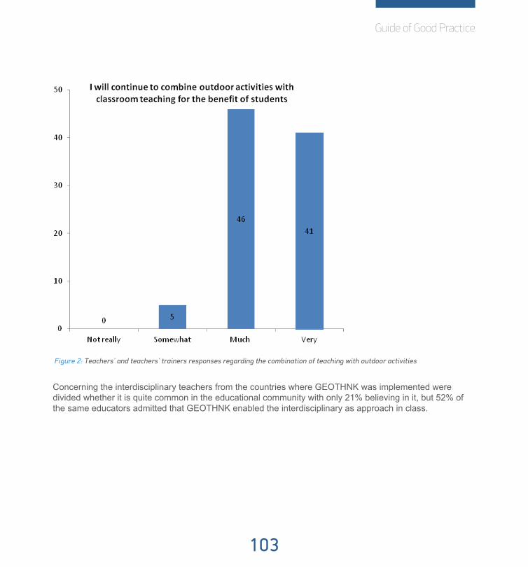
Guide of Good Practice
103
Figure 2: Teachers’ and teachers’ trainers responses regarding the combination of teaching with outdoor activities
Concerning the interdisciplinary teachers from the countries where GEOTHNK was implemented were divided whether it is quite common in the educational community with only 21% believing in it, but 52% of the same educators admitted that GEOTHNK enabled the interdisciplinary as approach in class.

104
Figure 3: Teachers’ and teachers’ trainers responses about interdisciplinarity
Also, it has been shown through their responses that GEOTHNK did have a great impact on their teaching geo related notions as most found it feasible to follow GEOTHNK activities in class, 43% of them found that representation tools facilitated the elaboration of scenarios in class and as overall 92% of the educators who used GEOTHNK in class admit that the teaching of geo sciences became more attractive for students after the use of GEOTHNK.

Guide of Good Practice
105
Figure 4: Teachers’ and teachers trainers’ responses regarding the students’ change of attitude
Last, the vast majority (71%) claimed that they will continue contributing the GEOTHNK platform with educa-tional content and 83% of them will visit the GEOTHNK community to stay updated with what is new in spatial thinking, making GEOTHNK platform a fertile ground for all representatives of at least formal learning context who are interested in the development of spatial thinking; besides 48% of the have stated that the strongly believe that online educational communities are supporting the professional development of teachers
From their responses it becomes obvious that teachers overall enjoyed their and their students involvement in GEOTHNK activities and that they will continue its use in class when they will be interested in developing the geospatial skills of their students thorough interdisciplinary activities. Along it is apparent that they will embrace the bridging of formal and informal learning context with including outdoor activities in their teaching in order to maximize their goal of establishing geospatial thinking in the minds of their students. Last, they will take advantage of the professional benefits that GEOTHNK provided for teachers and teachers’ trainers via the educational communities.

106
5.3.2. University StudentsMethodology
University students have completed the Basic Notions Questionnaire as it has been described earlier in section 5.3.1 of this document and in the second phase they had to complete questionnaires which enclosed questions based on the standardised model of IMI. IMI is a multidimensional measurement model intended to assess participants’ subjective expedience related to a target activity. Nevertheless, minor changes in the questions for the best fit to the GEOTHNK needs were applied without jeopardising its validity. The question-naire focused on the activity response by the University students and the manner they received it. Teaching by using the GEOTHNK content and tools was included in the activity examined. It is useful to mention that IMI tests use a scale 1 to 7 to count how true a statement made in the questionnaire is found by the participant, with 1 representing “not at all true” and 7 representing “very true”. Along there are some reverse statements, which means that these items should be scored accordingly in reverse.
Validation activities involving University students took place in Bulgaria (198) and Greece (53) and in total 211 students have been participated.
AnalysisThe university students’ responses it is obvious that they think highly of the significance of the navigational
skills in everyday life and the importance of keep developing them throughout life. They do not consider that todays’ students miss such skills and most of them believe that spatial thinking can be applied in various fields. Last, they support through their answer the cooperation of formal and informal learning context when the teaching content regards geo sciences, as it can also be seen in the graph below.
Figure 5: University students’ responses regarding the learning context

Guide of Good Practice
107
University students provided also with input after they had a GEOTHNK experience. IMI test have a special way to be analysed according to which the outcome will be divided into three different directions: a. interest/enjoyment, b. value/usefulness and c. perceived choice.
a. Interest/enjoyment
According to the answers they gave to the questions examining the interest and the enjoyment students had during their GEOTHNK activity it is shown that the vast majority enjoyed the experience as 44% of them declared that following and educational pathways via GEOTHNK platform was fun ad 57% stated that they were enjoying being taught via GEOTHNK. Last, 41% of the university students admitted that they would describe the experience as very fun.
Figure 6: University students responses about their GEOTHNK experience
b. Value/usefulness
University students also replied to questions evaluating the value and usefulness of the GEOTHNK experi-ence they participated in. It is apparent that 45% of the participants believed that the GEOTHNK platform has been proven useful for improved concentration and 42% stated that they believe that GEOTHNK is important for their improvement, which is not a surprise if one thinks that 55% of them declared that they think being

108
taught via GEOTHNK was important. A noteworthy group of them believe that GEOHNK could improve their studying habits (38%), that it was beneficial for them (40%) and that they think it has a value for them (41%).
Figure 7: Responses about the importance of GEOTHNK
c. Perceived choice
As for the perceived choice, by the answer university students provided it is obvious that it was their free choice to participate in this GEOTHNK experience and that that had the opportunity to exclude themselves with overall percentages above 55%.
Figure 8: University students’ responses of on the perceived choice of participating
Guide of Good Practice
109
In total, the impression formed by the university students’ responses regarding GEOTHNK is that they are truly interested in this initiative and they found it very enjoyable while using its. Additionally they realized that there was added value for them using it and that none of them have participated in the GEOTHNK activity against their will.
5.3.3 Science Centre EducatorsMethodology
Again, science centre educators had to firstly complete the Basic Notion Questionnaire. After their involve-ment of designing and implementing GEOTHNK activities they had to complete a questionnaire pretty similar to the Practice Reflection Questionnaire for Formal Learning Context. The key difference between the two was that it was addressed to science centre’s educators. Hence the questions were adapted to the informal learning context and to the different application environments. Nonetheless, the questions were seeking for reactions regarding the pedagogical approach applied in science centres and museums so far, their views on spatial thinking and its growth and last to portray the responses they attain by the visitors regarding the issue of the space. Also, questions highlighting the relation between formal and informal learning context will be included. This type of questionnaire supported a scale of four stages amongst which the participants had to select: a. not really, b. somewhat, c. much and d. very much.
The validation activities regarding science centre educators have taken place in the Netherlands (11) and Austria (20) where eventually, the number exceeded the initial target (10) by 52%.
AnalysisScience centre educators have also completed the basic notions questionnaire where they clarified that
they believe in the significance of the development of geospatial skills (45%). From their perspective today’s students and citizens do not lack geo skills, as only 9% claimed against that. Last, 45% of them trust that the geo science teaching should be combined with outdoor activities.

110
Figure 9: Science Centre’s educators’ responses on the combination of teaching with outdoor activities
Science centre educators had the opportunity to also complete another questionnaire once they have ex-perience the use of GEOTHNK. According to their responses it is apparent that they have welcomed the use of GEOTHNK in their routine as 58% of those questioned have admitted that visitors found their involvement in GEOTHNK enjoyable and 77% claimed that it was petty feasible for the visitors to follow the GEOTHNK activities. Along, the vast majority (67%) have declared that the representation tools offered by GEOTHNK facilitated the knowledge gaining and 54% of the science centre educators found it easy to include them in the educational material they have created.
Regarding the bridging of formal and informal learning context 38% of them believe that the GEOTHNK ap-proach encourages at some extent the link and the vast majority admitted that it was useful to combine the exhibits with the teaching context in class. Additionally 90% of them admitted that they will continue to cooper-ate with teachers for the benefit of the students.

Guide of Good Practice
111
Figure 10: Science Centre educators’ responses concerning interdisciplinarity
As for the interdisciplinary approach suggested by GEOTHNK, participants 38% of them suggested that sci-ence centres quite commonly support the interdisciplinarity and museums and they believe that GEOTHNK can enable activities of that form.
Also, a little less than the half of those participated (38%) admit that due to GEOTHNK they learnt the use of the reasoning tools and 64% stated that visitors really enjoyed using reasoning tools. Last, 41% of the participating representatives of informal learning context admitted that they would continue to visit GEOTHNK community to stay updated with what is new in spatial thinking.
Overall, science center educators as representatives of the informal learning context through their respons-es helped to make apparent that their GEOTHNK experience has been very enjoyable both form them and for the visitors for whom they have created the educational material. They also appeared open to cooperation with teachers and teachers’ trainers in order to promote a link between the two, which will effect on optimum results in the developing of geospatial skills. Last, they highlighted the significance of interdisciplinarity in the development of geospatial thinking, which is endorsed by GEOTHNK.

112
5.3.4 Adult LearnersMethodology
It was decided that the most fit option for this target group would be an IMI short test after their GEOTHNK experience and the Basic Notion questionnaire. Again the aim was to receive input regarding their visit and to record how differently they accepted the knowledge they gained through this informal learning context activity.
Although, IMI is a specific measurement model, some changes have been made, as presented in D6.2 sec-tion d. Therefore, it is believed that it would be advisable and also valid to respect their time and to shape a questionnaire shorter than those of the other target groups, but with more inclusive questions. It is useful to mention, that IMI tests use a scale 1 to 7 to count how true a statement made in the questionnaire is found by the participant, with 1 representing “not at all true” and 7 representing “very true”. Along there are some reverse statements, which means that these items should be scored accordingly in reverse.
In total, 43 adult learners have participated form the Netherlands.
AnalysisIn the basic questionnaire adult learners were quite divided in their responses without providing a concrete
image of what an average adult learner regards of the development of geospatial skills, For example 39% considered that navigational skills are important in everyday lie and 39% considered it as very important. Likewise, 23% of the participants believed that today’s students and citizens do not lack geo skills at all, 27% that they rather do, 25% believe they do and 23% admit that they do miss navigational skills, as shown in the figure below.
Figure 11: Adults learners responses on students’ and citizens’’ geo skills

Guide of Good Practice
113
But, on the whole, they believe that spatial thinking can apply in various fields and they feel that the teaching of geo sciences should be a combination of formal and informal learning context.
As for the after-the-involvement questionnaires it was again a case of IMI tests customized to the needs of the visitors of science museums and science centres. Therefore, the analysis will be divided into three sec-tions, similarly to the analysis of University students’ responses as presented in this document in section 2.2: a. interest/enjoyment, b. value/usefulness and c. perceived choice.
a. Interest/enjoyment
Regarding their interest in the GEOTHNK activity they have participated 49% of the participants stated that they were truly enjoying while participating and 60% of them admit that they did not find it boring. Moreover 35% of the visitors would describe it as a fun activity.
Figure 12: Adult learners’ responses regarding their interest
b. Value/ Usefulness
Visitors of science centres and museums (28%) apparently noticed improved concentration and 40% of the participants believed that GEOTHNK was somewhat beneficial for them. Last 63% of them admitted that are

114
willing to use the GEOTHNK platform again because they believe it has some value for them.
Figure 13: Adult Learners’ responses regarding value/usefulness
c. Perceived choice
Last, regarding the perceived choice of the participants from their responses it becomes very clear that they took part in the activity as result of their free will as almost 70% of them declare that they did not use GEO-THNK platform during their visits to museum/science centre because they had to.

Guide of Good Practice
115
Figure 14: Adult Learners’ response regarding perceived choice
On the whole, adult learners as one of the target groups of GEOTHNK have shaped a quite straightforward image of their beliefs about GEOTHNK according to which they found it pretty enjoyable and fun as an experi-ence and they truly believed that there was an increased values in participating in this GEOTHNK experience regarding the development of their geospatial skill.
5.3.5 The Bridging of Formal and Informal learning Context within GEOTHNK
Throughout the validation procedures also some common workshops for bridging formal and informal learn-ing context have been planned according to which representatives of both parts would express their view on the subject. These workshops only took place in those countries that have realized implementation activities: namely Greece, Netherlands, Romania and Bulgaria.

116
Partners who have organized such workshops had to follow a scenario with specific and common questions. The questions were seeking for answers regarding the GEOTHNK and its approach but there was also a special focus on the possible cooperation of school education with extra- curriculum activities.
All in all, it seems that GEOTHNK has been welcomed with statements like: “GEOTHNK is a very good platform for training and it takes into consideration all the conditions for spatial thinking” proving it. Regarding the acceptance from the receivers’ point of view -students and visitors’ point of view in this case- they admit-ted that they seemed more motivated and concentrated. The majority found the educational material useful and without difficulty applied into various fields of interest and at the same time they believed it was easy for them to include GEOTHNK practices in their daily customs. Also some stated that dealing with GEOTHNK seemed as a challenge, as an opportunity to cooperate with other institutions or schools and as a break from their routine. They really enjoyed the enhancement of interdisciplinary as it offered them the chance to also teach humanities. As for the students, their teachers believe that they have been challenged to explore new ways in spatial orientation and to use technology or the needs of learning. At the same time there were those who declared that GEOTHNK should have had some customizations in order to be used by the visitors of a science centre or museum when they are e.g. family as in that case they are mostly interested in the visit and not the structured pedagogical approach suggested by GEOTHNK; however, it seemed to be useful for school visits. What was considered as a pleasant surprise by the majority was the tools introduced by GEO-THNK were the representation tools.
Last regarding the bridging of formal an informal context the majority believe that although it seems difficult, good organisation can help to overcome the differences and that they would all be willing to cooperate. Be-sides as it has been stated “School groups always have a new sense of understanding after doing hands-on activities”. Meanwhile, there were those who believe that they may face difficulties once they will have to assess their students; however they have also stated that possible difficulties have to be addressed by the human factor (students, teachers, contributors, etc.). At the same time, it has been mentioned that in informal learning contexts it is always helpful for them to hold already prepared material because they have to be creative. Summing up they have also commented on the curriculum barriers, which exclude outdoor activities in many cases.

Guide of Good Practice
117
5.3.6 Web Analysis
IntroductionRegarding the web analysis of GEOTHNK platform we will follow two paths of quarrying information:
a. Google analytics
b. Analytics provided by …..
Results and DiscussionThe image shaped when studying the Google analytics is very confident and rewarding for the efforts made
by the GEOTHNK consortium. One whole year has been analysed, counting from the time that the validation plan was published (November 2014) till the end of October 2015. As it has becomes very apparent in the screenshot below through this time there have been 9,085 sessions made by 2,966 users. During their ses-sion users visited 4,73 pages, almost 5, and they stayed in the platform for a little less than 10 minutes. From all users 32,3% were new, but 67,7% were returning visitors and that highlights the usefulness of the platform and its richness in educational material. Last, the bounce rate is 36,55% which seems to be quite low.
Picture 5.3.6.a Google Analytics Overview Nov 2014-Oct 2015

118
Also, taking a closer look in the new and returning visitors, it is obvious that returning visitors are honestly engaged to the GEOTHNK products as their bounce rate is by 15,64% less and they visit 1,77 pages more in every session they have. Moreover returning visitors are staying 00:05:47 more minutes in an average ses-sion than new visitors as it can be seen in the screenshot below.
Picture 5.3.6.2 Google Analytics Returning vs. New visitors Nov 2014-Oct 2015
Meanwhile, by analyzing the count of session it becomes apparent that although as expected there is big number of visitors who only have one experience of GEOTHNK, which however is quite detailed taken that they visit more than 10 pages in their average session, the number of sessions starts rising again for visitors who have more than 9 sessions in GEOTHNK. Also, judging from their activity in the platform they visit pages closer to average page view as they are aware of the products of the platform and they are directed straight at the specific pages they want to make use of. It is noteworthy that the data displayed in Picture 3 refers both to new and returning visitors, which also explains the existence of the first row, where number of sessions is 1.
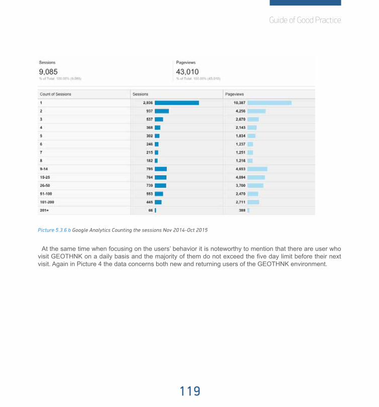
Guide of Good Practice
119
Picture 5.3.6.b Google Analytics Counting the sessions Nov 2014-Oct 2015
At the same time when focusing on the users’ behavior it is noteworthy to mention that there are user who visit GEOTHNK on a daily basis and the majority of them do not exceed the five day limit before their next visit. Again in Picture 4 the data concerns both new and returning users of the GEOTHNK environment.

120
Picture 5.3.6.c Google Analytics Counting the days since last session Nov 2014-Oct 2015
Furthermore, the screenshot below proves the engagement of the GEOTHNK users as those who have realized many sessions (more than 1,000) have stayed more than 61 minutes and their pageviews are closer to the average.
Picture 5.3.6.d Google Analytics Engagement Nov 2014-Oct 2015
Moreover, examining the use of mobile devices it is obvious that desktop dominates as the device mostly used by GEOTHNK users, which comes not as a surprise. But at the same time as it can be seen in Picture 6 from Google Analytics, there are also those who have visited the GEOTHNK platform through mobile devices and tablets most probably from science centres and museums. What is also noteworthy is that the behavior of those using GEOTHNK via mobile and tablets is totally differing for those using desktop. Their visit is quicker and the page views consequently and that is also another proof that informal learning contexts need lees structured approached in order to be implemented as their behaviour of the uses is utterly unlike to that of those working in school environments.

Guide of Good Practice
121
Picture 5.3.6e Google Analytics Mobile Use Nov 2014-Oct 2015
In the framework of GEOTHNK and in order to study the behavior of the GEOTHNK user, some hypotheses have been developed regarding the goals of the visit and the path that the users follow within the environment of the platform. We have formed two optimum characters: a. the lurker, who searches for educational content and b. the contributor, who created original educational material within the GEOTHNK environment using the authoring tool.
The data obtained from Google Analytics show in Picture 1 that 2,966 unique users have visited GEOTHNK from November 2014 until end of October 2015. If we exclude those users as the bounce rated predicts (36.55%), the number of actual unique users turns to 1,882. On the homepage of the GEOTHNK community one can see that there are so far 648 register users and 400 resources hosted (see Picture6 and Picture7).
Picture 5.3.6g Geothnk community homepage /peoplePicture 5.3.6.f Geothnk community homepage /resources

122
According to the internet culture, the 1% rule is a canon that portrays the participation in an online commu-nity, declaring that only 1% of the users of a website actively create original content, whereas the other 99% of the participants only navigate. The table3 shows how these numbers interact.
Table 5.3.6.a. Data for the user of GEOTHNK from Google Analytics and GEOTHNK community vs. 1% rule
That is a clear success of the GEOTHNK which exceeds by far the 1% rule. In GEOTHNK 20% of the users contributed creating their own educational material instar of 1% which is considered to be the prediction and 32% of the users are interested to know more and they navigate which is 23% more than that is foreseen by the 1% law.
Another hypothesis has been shaped regarding the path they follow in each case once they have already visited the GEOTHNK homepage, which is as follows:
a. the lurker
1. click on resources
2. search within the resources
3. select the resource
4. navigate in resource
4 clicks
b. the contributor
1. click on resources
2. create new
3. click on the kind of the resource
4. click on the template of the resource
5. click save and view
6. click to make it final
Numbers Percentages 1% ruleVisitors 1,882 100% ~
Registered users 648 32% 9%
Contribute 40 20% 1%

Guide of Good Practice
123
7. click save
8. click to return to homepage
9. click on resources
10. search within the resources
11. select her/his resource
12. navigate in her/his resource
12 clicks
From Table 1 it is known that the average page view (clicks) per visit is 6,49 for returning visitors. That equals and is the averaged formed by the 4 clicks made by lurkers and the 12 made by contributors and in that case the percentage of contributors touches 30% , which is very close to the calculations made earlier.
5.3.7 ConclusionThis has been a detailed presentation of the analysis performed on the data obtained during the validation
activities of GEOTHNK. The validation instruments and feedback tools developed have proven to be effec-tive as they both worked perfectly with different target groups participating (teachers and teachers’ trainers, university students, science centre educators, adult learners) and they provided with useful information as a response to the research questions set in the Validation Plan D6.2: a) Increases learner motivation for learning; b) expands learners’ conceptions of learning and knowledge on geospatial issues and c) develops new student skills and abilities (geospatial thinking) in a framework of developing a methodology to involve learners in innovative learning experiences that are developed on the effective bridging of formal and informal learning context.
a. Increase learners’ motivation for learning
It has been proven that GEOTHNK succeeded in that target as representatives from both learning contexts. Teachers and teachers’ trainers admitted that students found it feasible to follow the GEOTHNK activities and that student enjoyed using reasoning tools that were suggested by GEOTHNK .Meanwhile, science centre educators noticed that visitors of science centres and museums found their involvement GEOTHNK enjoy-able and that again it was feasible for them to follow GEOTHNK activities. They have also made use of rep-resentation and reasoning tools suggested by GEOTHNK and adult learners seemed to enjoy their existence. Most importantly they declared that geo sciences’ issues became more attractive for adult learners after the use of GEOTHNK. Also they admitted that the approach.
From the receivers’ side adult learners admitted through after-their-involvement questionnaire that did en-

124
joy using the GEOTHNK platform and that they found it useful for improved concentration during visiting the exhibits. They found it and interesting experience which was also beneficial for them and they are willing to visit it again as they find it valuable from them. In the same setting university students stated they believe that being taught via GEOTHNK could help them do better in school apart from mentioning that they found the experience as interesting. Also, they found that GEOTHNK platform was important for their improvement.
b. Expand learners’ conception of learning and knowledge on geospatial issues
In this area again the data provided proved that they achieved the target. Teachers and teachers’ trainers declared that students’ spatial thinking skills have been improved after their involvement in GEOTHNK and that even the educational framework was the most appropriate pedagogical approach for communicating geosciences. In the meantime, students were familiarized with the use of reasoning and representation tools suggested by GEOTHNK platform which are fundamental and at the same time beneficial for the preeminent teaching of geospatial issues.
In the very same perspective they agreed that GEOTHNK educational pathways eased the teaching of geo sciences. Science centre educators also found that adult learners enjoyed the use of representation and reasoning tools and that in their case the involvement as contributed to the development of problem-solving skills of the adult learners. Overall, they found that geo sciences issues became more attractive for students after the use of GEOTHNK and the also the GEOTHNK pedagogical framework has eased the teaching of geo sciences.
c. Development new students’ skills and abilities
Regarding skills and abilities again it is obvious that the goal was succeeded as teachers and teachers’ trainers declares that there has been improvement after their involvement and that they were familiarize with kind of tools that were new to them, namely representation and reasoning tools; the same group of people have admitted they did not use to use such tools in class before their involvement and that they only learnt about their practice from GEOTHNK. In the meanwhile science centre educators admitted that through the development of spatial thinking people-solving skills are also empowered.
Overall, the responses provided by mostly the teachers, teachers’ trainers and science centre educators show that they are very willing and open to promote the actual bridging of the two learning contexts: the for-mal and informal learning context. They have proved so by supporting that interdisciplinarity is quite common for science centre educators and that they are very willing to cooperate with teachers for the benefit of the students. Teachers and teachers’ representatives on the other hand also support the same idea as they admit that interdisciplinarity is also common in their community and that they are open to combine outdoor activities with classroom teaching for the benefit of students. Moreover, they have both suggested that GEOTHNK ap-proach encouraged the link between formal and informal learning contexts.
Summing up it is obvious that GEOTHNK has managed to achieve the goals set in the beginning with all

Guide of Good Practice
125
target groups involved. The representatives of the informal learning context (science centre educators and adult learners) were not as enthusiasts as teachers and teachers’ trainers and university students, but that was expected and as GEOTHNK was suggesting a quite structured approach which is somehow contradic-tive with the basis of informal learning context. However, still the results are more than satisfying and show that they also enjoyed their involvement and that there was impact noted after their GEOTHNK experience.

126
5.4 Appendix
5.4.1 Basic notions Questionnaire
Thank you!
Please fill in a code by the date and month of birth and the first two letter of the city you were born.
Example: born 02/11/79 in Sofia 0211SO Your code:
Now, please answer each question by putting a check in the box.
1 Navigational skills are important in everyday life.
Not really Somewhat Much Very much
2Spatial thinking is essential and it has to be developed throughout our lives.
Not really Somewhat Much Very much
3 Today’s students and citizens lack geo skills.
Not really Somewhat Much Very much
4Spatial thinking can apply in vari-ous fields.
Not really Somewhat Much Very much
5Geo sciences teaching should be a combination or teaching and outdoor activities
Not really Somewhat Much Very much

Guide of Good Practice
127
5.4.2 Practice reflection Questionnaire for Formal Learning Context
Please fill in a code by the date and month of birth and the first two letter of the city you were born.
Example: born 02/11/79 in Sofia 0211SO Your code:
Now, please answer each question by putting a check in the box.
1Students’ spatial thinking skills have been improved after their involvement in GEOTHNK.
Not really Somewhat Much Very much
2Inquiry Based Model is the most appropriate pedagogical approach for the teaching of geosciences.
Not really Somewhat Much Very much
3The interdisciplinarity is quite common in the educational community.
Not really Somewhat Much Very much
4 It was pretty feasible to follow the GEOTHNK activities in class.
Not really Somewhat Much Very much
5It was useful to combine geo issues teaching with outdoor activities.
Not really Somewhat Much Very much
6The representation tools (e.g., maps, images, etc.) facilitate the elaboration of scenarios.
Not really Somewhat Much Very much
7 GEOTHINK enabled the interdisciplinarity.
Not really Somewhat Much Very much

128
8I have never used reasoning tools (e.g., measuring distances/areas in google earth, computing optimal route, etc.) for the teaching of geo sciences
Not really Somewhat Much Very much
9I will continue to combine outdoor activities with classroom teaching for the benefit of students.
Not really Somewhat Much Very much
10Students enjoyed using reasoning tools (e.g., measuring distances/areas in google earth, computing optimal route, etc.).
Not really Somewhat Much Very much
11It was easy to include representation tools (e.g., maps, images, etc.) during teaching.
Not really Somewhat Much Very much
12Spatial thinking empowered the problem-solving skills of students.
Not really Somewhat Much Very much
13Geo sciences’ teaching became more attractive for students after the use of GEOTHNK.
Not really Somewhat Much Very much
14Online educational communities are supporting the professional development of teachers.
Not really Somewhat Much Very much
15Do you find supportive the Set of Concepts (attached) for the development of educational pathways?
Not really Somewhat Much Very much
16 Educational pathways eased the teaching of geo sciences
Not really Somewhat Much Very much

Guide of Good Practice
129
Thank you!
17 The GEOTHNK authoring tool is easy to use.
Not really Somewhat Much Very much
18I will continue contributing the GEOTHNK platform with educational content.
Not really Somewhat Much Very much
19I will visit the GEOTHNK community to stay updated with what is new in spatial thinking.
Not really Somewhat Much Very much
20 Please, suggest new Concepts.

130
5.4.3. Practice Reflection Questionnaire for Informal Learning Context
Please fill in a code by the date and month of birth and the first two letter of the city you were born.
Example: born 02/11/79 in Sofia 0211SO Your code:
Now, please answer each question by putting a check in the box.
1 Visitors found their involvement in GEOTHNK enjoyable.
Not really Somewhat Much Very much
2The GEOTHNK approach can encourage the link of formal and informal learning context.
Not really Somewhat Much Very much
3The interdisciplinarity is quite common in the supported by science centres and museums.
Not really Somewhat Much Very much
4It was pretty feasible for the visitors to follow the GEOTHNK activities.
Not really Somewhat Much Very much
5It was useful to combine the exhibits with the teaching context in class.
Not really Somewhat Much Very much
6The representation tools (e.g., maps, images, etc.) facilitate the knowledge gaining.
Not really Somewhat Much Very much
7 GEOTHINK enabled the interdisciplinarity.
Not really Somewhat Much Very much

Guide of Good Practice
131
8I have never used reasoning tools (e.g., measuring distances/areas in google earth, computing optimal route, etc.) for organizing a visit geo sciences
Not really Somewhat Much Very much
9I will continue to cooperate with teachers for the benefit of students.
Not really Somewhat Much Very much
10Visitors enjoyed using reasoning tools (e.g., measuring distances/areas in google earth, computing optimal route, etc.).
Not really Somewhat Much Very much
11It was easy to include representation tools (e.g., maps, images, etc.) in the pathways.
Not really Somewhat Much Very much
12 Spatial thinking empowers the problem-solving skills.
Not really Somewhat Much Very much
13Geo sciences’ issues became more attractive for students after the use of GEOTHNK.
Not really Somewhat Much Very much
14Online educational communities are containing valuable educational content.
Not really Somewhat Much Very much
15Do you find supportive the Set of Concepts (attached) for the development of educational pathways?
Not really Somewhat Much Very much
16 Educational pathways eased the teaching of geo sciences.
Not really Somewhat Much Very much
132
Thank you!
17 The GEOTHNK authoring tool is easy to use.
Not really Somewhat Much Very much
18I will continue contributing the GEOTHNK platform with educational content.
Not really Somewhat Much Very much
19I will visit the GEOTHNK community to stay updated with what is new in spatial thinking.
Not really Somewhat Much Very much
20 Please, suggest new Concepts.

Guide of Good Practice
133
5.4.4 IMI questionnaire for University Students
Please fill in a code by the date and month of birth and the first two letter of the city you were born.
Example: born 02/11/79 in Sofia 0211SO Your code:
Please answer all items.
For each item, please indicate how true the statement is for you, using the following scale as a guide:
1 2 3 4 5 6 7
not at all true somewhat true very true
1 I believe that using the GEOTHNK platform could be of some value for me.
2 I believe I had some choice about being taught via the GEOTHNK platform.
3 While I was taught via the GEOTHNK platform, I was thinking about how much I enjoyed it.
4 I believe that being taught via the GEOTHNK platform is useful for improved concentration.
5 Following an educational pathway from GEOTHNK was fun to do.
6 I think being taught via GEOTHNK platform is important for my improvement.
134
7 I enjoyed being taught via GEOTHNK platform very much.
8 I really did not have a choice about following an educational pathway from GEOTHNK.
9 I followed the educational pathway in GEOTHNK platform because I wanted to.
10 I think being taught via GEOTHNK was important.
11 I felt like I was enjoying the being taught via GEOTHNK while I was doing it.
12 I thought following an educational pathway in GEOTHNK platform was a very boring activity.
13 It is possible that being taught via GEOTHNK platform could improve my studying habits.
14 I felt like I had no choice but to do this follow the educational pathways of GEOTHNK platform.
15 I thought following the educational pathway in GEOTHNK platform was very interesting.
16 I am willing to follow an educational pathway in GEOTHNK platform again because I think it is somewhat useful.

Guide of Good Practice
135
Thank you!
17 I would describe following the educational pathway in GEOTHNK platform as very enjoyable.
18 I felt like I had to follow the educational pathway in GEOTHNK platform.
19 I believe following the educational pathway in GEOTHNK platform could be somewhat beneficial for me.
20 I followed the educational pathway in GEOTHNK platform because I had to.
21 I believe being taught via GEOTHNK could help me do better in school.
22 While doing following the educational pathway in GEOTHNK platform I felt like I had a choice.
23 I would describe following the educational pathway in GEOTHNK platform as very fun.
24 I felt like it was not my own choice to follow the educational pathway in GEOTHNK platform.
25 I would be willing to follow the educational pathway in GEOTHNK platform again because it has some value for me.

136
5.4.5 IMI questionnaire for Adult Learners
Please fill in a code by the date and month of birth and the first two letter of the city you were born.
Example: born 02/11/79 in Sofia 0211SO Your code:
Please answer all items.
For each item, please indicate how true the statement is for you, using the following scale as a guide:
1 2 3 4 5 6 7
not at all true somewhat true very true
1 While I was using the GEOTHNK platform, I was thinking about how much I enjoyed it.
2 I believe that using the GEOTHNK platform is useful for improved concentration.
3 I really did not have a choice about using the GEOTHNK platform.
4 I thought using the GEOTHNK platform was a very boring activity.
5 I felt like I had no choice but to use the GEOTHNK platform
6 I thought using the GEOTHNK platform was very interesting.

Guide of Good Practice
137
Thank you!
7 I felt like I had to use the GEOTHNK platform.
8 I using the GEOTHNK platform could be somewhat beneficial for me.
9 I used the GEOTHNK platform because I had to.
10 I would describe using the GEOTHNK platform as very fun.
11 I felt like it was not my own using the GEOTHNK platform.
12 I would be willing to use the GEOTHNK platform again because it has some value for me.
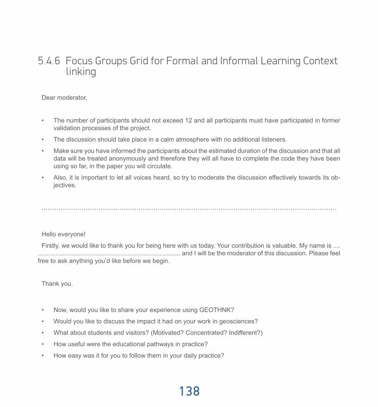
138
5.4.6 Focus Groups Grid for Formal and Informal Learning Context linking
Dear moderator,
• The number of participants should not exceed 12 and all participants must have participated in former validation processes of the project.
• The discussion should take place in a calm atmosphere with no additional listeners.
• Make sure you have informed the participants about the estimated duration of the discussion and that all data will be treated anonymously and therefore they will all have to complete the code they have been using so far, in the paper you will circulate.
• Also, it is important to let all voices heard, so try to moderate the discussion effectively towards its ob-jectives.
````````````````````````````````````````````````````````````````````````````````````````````````````````````````````````````````````````````
Hello everyone!
Firstly, we would like to thank you for being here with us today. Your contribution is valuable. My name is ..................................................................................... and I will be the moderator of this discussion. Please feel free to ask anything you’d like before we begin.
Thank you.
• Now, would you like to share your experience using GEOTHNK?
• Would you like to discuss the impact it had on your work in geosciences?
• What about students and visitors? (Motivated? Concentrated? Indifferent?)
• How useful were the educational pathways in practice?
• How easy was it for you to follow them in your daily practice?

Guide of Good Practice
139
• Would you continue to use representation and reasoning tools?
• How did the Set of Concepts ease your work?
• How feasible do you think is the cooperation between formal and informal learning context?
• How easy would it be to overcome the key differences -time, purpose, relationship, orientation, evalua-tion- between the two?
• Will you seek for that kind of cooperation?
Finish the discussion by thanking them for their participation.

GEOTHNK Guide of Good Practice

ISBN: 978-960-473-682-9
GEOTHNK Guide of Good Practice
www.geothnk.eu
With the support of the Lifelong Learning Programme of the European Union Pr. no 543451-LLP-1-2013-1-GR-KA3-KA3MP