gps early warning system for s....
TRANSCRIPT

Yehuda Bock and Brendan CrowellCecil H. and Ida M. Green Institute of Geophysics and
Planetary PhysicsScripps Institution of Oceanography
La Jolla, California
GPS Early Warning System for S. California
2008 HPWREN Users MeetingPala Native American Reservation
November 19, 2008

California Real Time Network (CRTN)
(http://sopac.ucsd.edu/projects/realtime/)
• Stations span major faults of southern San Andreas fault system
•Raw GPS data streamed over dedicated radio links (including HPWREN) with a latency of a fraction of a second
• Total displacement waveforms are generated independently every second by instantaneous positioning
• 10-20 Hz data rates have been demonstrated
Real Time (Active)
CGPS.

Test Bed for Early Warning Systems
Earthquake Geodesy (coseismic motions)GPS Seismology (dynamic motions)Volcano monitoringStructural monitoringLandslide monitoringTsunami warningFlood Control
2004 Stromboli eruption LA freeway after 1994
Northridge earthquake
Displacement waveforms, 2004 Parkfield event
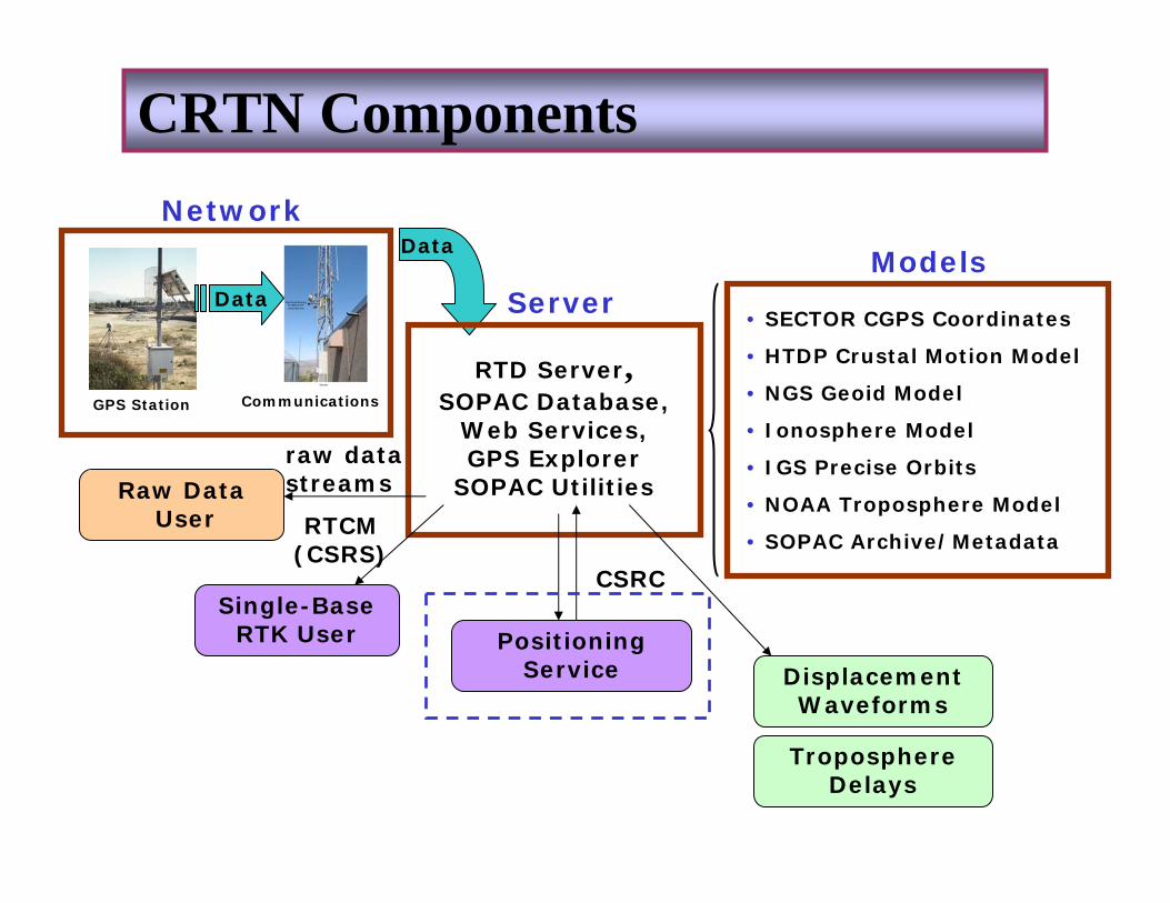
RTD Server,SOPAC Database,
Web Services, GPS Explorer
SOPAC Utilities
Data
Communications
Data
Network
• SECTOR CGPS Coordinates
• HTDP Crustal Motion Model
• NGS Geoid Model
• Ionosphere Model
• IGS Precise Orbits
• NOAA Troposphere Model
• SOPAC Archive/Metadata
ServerModels
Single-Base RTK User Positioning
Service
Raw DataUser
raw data streams
RTCM (CSRS)
CSRC
GPS Station
CRTN Components
Displacement Waveforms
Troposphere Delays

Imperial Valley Survey – October ‘08
• Three autonomous teams surveyed about 20 geodetic monuments each in 2-3 days
• Two 15-minute occupations of each monument
• Used CRTN Positioning Service to compute ITRF2005 coordinates
• Positions available at the end of each occupation
• Ideal for post-earthquake surveys
http://sopac.ucsd.edu/projects/caltrans_iv2008.html
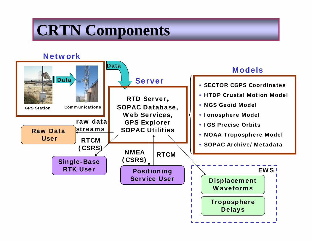
RTD Server,SOPAC Database,
Web Services, GPS Explorer
SOPAC Utilities
Data
Communications
Data
Network
• SECTOR CGPS Coordinates
• HTDP Crustal Motion Model
• NGS Geoid Model
• Ionosphere Model
• IGS Precise Orbits
• NOAA Troposphere Model
• SOPAC Archive/Metadata
ServerModels
Single-Base RTK User Positioning
Service User
Raw DataUser
raw data streams
NMEA (CSRS)
RTCM (CSRS)
RTCM
GPS Station
CRTN Components
Displacement Waveforms
Troposphere Delays
EWS

Japan’s Geophysical Survey Institute (GSI) operates nationwide 1200-station continuous GPS network (GEONET), with ~ 20 km spacing. Of these, 1156 stations are streaming @ 1 Hz to a central facility in Tsukuba City.
2003 Mw 8.3 Tokachi –Oki earthquake

Triangulation Scheme
• Create a Delaunay triangulation of the network every second
• Compute relative positions of each triangle
• Convert to principal components of strain (2D)
• Establish detection criteria to isolate an event
• Determine an anchor point for computing absolute positions
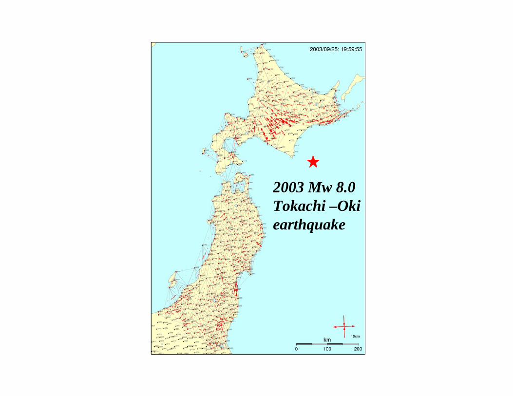
2003 Mw 8.0 Tokachi –Oki earthquake

Demo
ShakeOut

Total Displacement Waveforms

240˚ 241˚ 242˚ 243˚ 244˚ 245˚ 246˚
31˚
32˚
33˚
34˚
35˚
36˚
37˚240˚ 241˚ 242˚ 243˚ 244˚ 245˚ 246˚
31˚
32˚
33˚
34˚
35˚
36˚
37˚
AZRY
AZU1
BILL
BLSA
CAT2
CCCS
CIT1
CNPPCOTD
CRRS
CSDH
CVHS
DESC
DHLG
DSME
DVLEDVLSDVLWDVNEDVNWDVSEDVSW
DYHS
ESE2ESRW
EWPP
FVPK
GLRS
GMPK
GNPS
HBCOHNPS
HW62IMPS
KYVWLASC
LORS
MAT2MJPK
MLFP
MONP
MVFD
NSSS
OEOC
P066
P472
P473
P474P478
P480
P482
P483
P486
P494P497
P499
P500
P506
P509
P510
P566
P623
PIN1PIN2
PMOB
POTR
PPBF PSAP
RAAP
SACY
SBCC
SCIPSIO5
SKYB
SLMS
TABLTOST
TRAK
UCLP
UCSB
USGC
VDCY
VTIS WHYT
WIDC
1 m
100
100100
100
100
100
100
200
200
200
500
500500
1000
1000
Coseismic Displacement Model
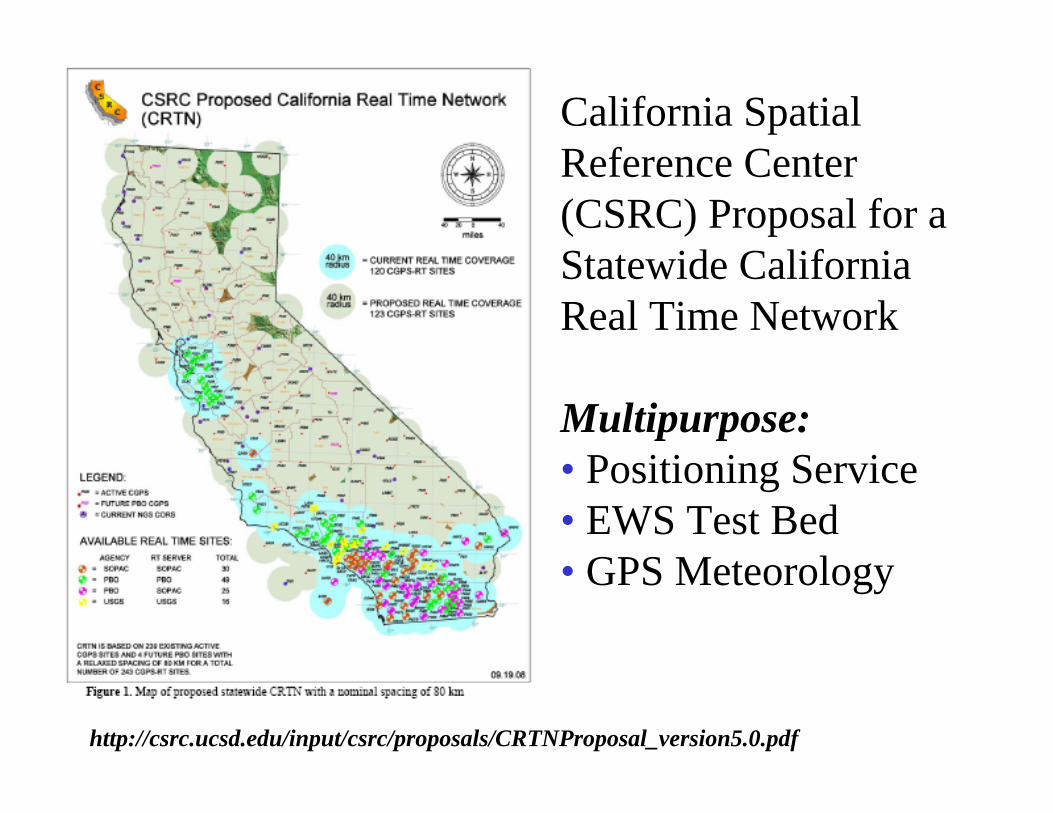
California Spatial Reference Center (CSRC) Proposal for a Statewide California Real Time Network
Multipurpose:• Positioning Service• EWS Test Bed• GPS Meteorology
http://csrc.ucsd.edu/input/csrc/proposals/CRTNProposal_version5.0.pdf