gold placers on wind and bighorn rivers, by … · gold placers on wind and bighorn rivers, ......
TRANSCRIPT
GOLD PLACERS ON WIND AND BIGHORN RIVERS,WYOMING.
By FRANK C. SOHEADER.
INTRODUCTION.
This paper contains a brief account of an examination of the gold placers on Wind and Bighorn rivers, in Fremont and Hot Springs counties, Wyo., made in connection-with land-classification work on the Shoshone Indian Reservation in the autumn of 1913.
For generous aid and information thanks are due Superintendent Norris and Chief Engineer E. E. Jones of the Wind River Indian Agency, to mining men, prospectors, and ranchers in the region, and to E. L. Crabb, surveyor at Shoshoni, for a valuable sectionized blue-print map of the ceded portion of the reservation.
LOCATION AND ACCESS.
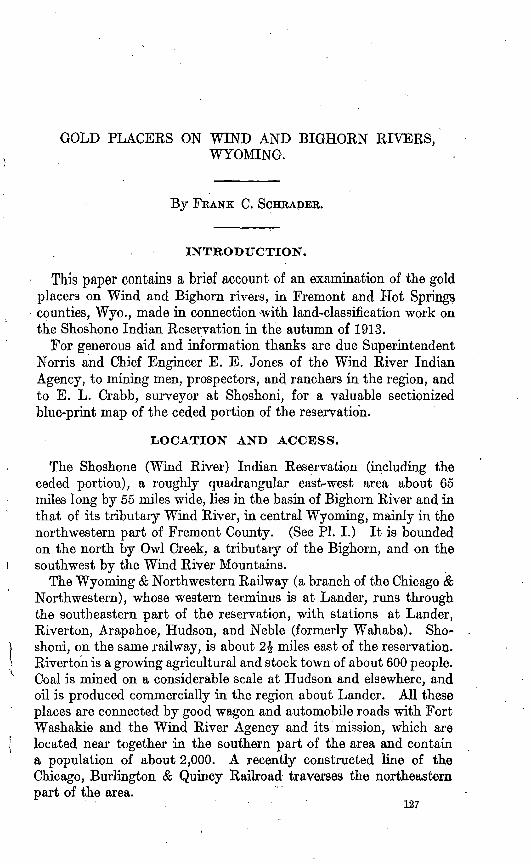
The Shoshone (Wind River) Indian Reservation (including the ceded portion), a roughly quadrangular east-west area about 65 miles long by 55 miles wide, lies in the basin of Bighorn River and in. that of its tributary Wind River, in central Wyoming, mainly in the northwestern part of Fremont County. (See PI. I.) It is bounded on the north by Owl Creek, a tributary of the Bighorn, and on the southwest by the Wind River Mountains.
The Wyoming & Northwestern Railway (a branch of the Chicago & Northwestern), whose western terminus is at Lander, runs through the southeastern part of the reservation, with stations at Lander, Riverton, Arapahoe, Hudson, and Neble (formerly Wahaba). Sho shoni, on the same railway, is about 1\ miles east of the reservation. Riverton is a growing agricultural and stock town of about 600 people. Coal is mined on a considerable scale at Hudson and elsewhere, and oil is produced commercially in the region about Lander. All these places are connected by good wagon and automobile roads with Fort Washakie and the Wind River Agency and its mission, which are located near together in the southern part of the area and contain a population of about 2,000. A recently constructed line of the Chicago, Burlington & Quincy Railroad traverses the northeastern part of the area.
127

128 COISTTKIBUTTOSTS TO ECONOMIC GEOLOGY/ 1913, PART I.
The wagon road which ascends Wind River diagonally across the area forms a main highway leading beyond Dubois, a large tie camp of 800 people, to the "biggame" hunting ground about the Continental Divide south of Yellowstone National Park, which is but 40 miles northwest of the area. The development of this road into a tourist approach to the park is contemplated. Considerable additional activity has been occasioned in the region by recent irrigation projects, and by the occupation of large tracts of the ceded portion of the reservation recently opened up to settlement.
TOPOGRAPHY.
The area in general slopes and drains toward the southeast, and also from the northeast and southwest toward the master stream, Wind River. On the southwest lie the Wind River Mountains, a high and rugged range which forms part of the Rocky Mountain system and in which rise nearly all the important tributaries of Wind River. On the north are the Owl Creek Mountains, which also are high and rugged, culminating at 9,000 feet above sea level, and which form the western continuation of the Bighorn Mountains. They extend through the northern part of the area and merge into the south end of the Absaroka'Mountains in its northwest corner.1
Wind River rises on the south slope of the Absaroka Mountains and the adjoining east slope of the Wind River Mountains, just opposite the headwaters of Snake River, from which it is separated by the narrow Continental Divide.2 It enters the area on the west at Circle and flows through it in a southeasterly direction. Near Riverton it unites with Popo Agie River to form Bighorn River, which flows northward for 50 miles along the eastern border of the area and thence northeastward into Montana, where it joins the Yellowstone, a tributary of the Missouri.
The elevation of Bighorn River in the eastern part of the area, at the head of Bighorn Canyon, where it cuts across the Owl Creek Mountains in a steep-sided trench 2,250 feet deep, is about 4,620 feet above sea level, and the elevation of Wind River at Circle, in the tipper or western part of the area, is about 6,600 feet. Along these rivers within and west of the area are numerous fine water- power sites, one of which, in Bighorn Canyon, is utilized by the Boysen dam project, which supplies power, light, and heat to neigh boring districts and towns.
The nonmountainous portion of the basin, occupying the greater part of the area, consists principally of broad rolling plains and smaller scattered badland areas, with intermediate erosion forms,
i Barton, N. H., Geology of the Owl Creek Mountains: S. Doc. No. 219, p. 10,1906. a The northwestern part of the area and the adjoining region on the north, northwest, and west are shown
on the Kirwin, Younts Peak, and Fremont topographic sheets of the United States Geological Survey.

U. S. GEOLOGICAL SURVEY BULLETIN 580 PLATE 1
^_io9yr -C
WILLOW CK^DISTRICT
S H O S H
Boundanr of area from which placer gold has been derived (mainly Wind River drainage basin)
Boundary of Shoshone Indian Reservation. (The ceded portion extends north toOwl Creek and east to and beyond Bighorn River
Location and number of sample
OUTLINE MAP OF THE WIND RIVER BASIN AND VICINITY, WYOMING.
Showing localities where tests were made in the gold placers of Wind River and its tributaries and Bighorn River. Base in part from the one-millionth scale map of the United States now inpreparation; balance compiled from various sources by the author.
GOLD PLACERS ON WIND AND BIGHORN RIVERS, WYO.
such as fragmentary mesas, flat-topped buttes, and sharp-crested, steep-sided ridges, separated by valleys and gulphes of steep gradient. Conspicuous examples are Boulder Flat, near Milford; Elkhorn Flat, near Fort Washakie; Reservoir Butte, near Shoshoni; Pilot Butte, near Pavilion; and Crow Heart Butte, near Lenore.
The plains rise from Wind River to 6,000 feet above sea level at the foot of the Owl Creek Mountains on the northwest and nearly 7,000 feet at the foot of the Wind River Mountains on the southwest. All the large streams carry excellent clear water and flow with brisk currents in flat-bottomed valleys. Bordering them, in general alter nately on either side, are mostly arable level alluvial bottoms or flats. The flats generally lie 4.to 10 feet above the level of the stream. They vary in width from more than a mile on Bighorn River in the eastern part of the area to 100 feet or less along the upper course of Wind River on the west. They are generally "ollowed by wagon roads between settlements and are occupied by ranches.
From the outer edge of the flats the surface rises, generally in a succession of terraces or gravel-covered benches, some of which, as at Riverton and above the mouth of Popo Agie River, are of great width, to heights of 100 feet or more above the river, where they give way to plains and other upland features.
GEOLOGY.
BEDROCK.
The geology of the area, except ,a belt about 15 miles wide along the southwest and west sides, has already been described, that of the southern part by Woodruff and Winchester* and that of the northern part by Darton.2
Almost the whole of the central interior or nonmountainous por tion of the basin is occupied by the Wind River formation (Eocene), which underlies the plains and in which the valleys and other topo graphic features are carved. It consists chiefly of gently inclined beds of soft sandstone and sandy shale, in places nearly 2,000 feet in thickness.
Locally, however, as along the crest of the Oil anticline (see PL I), the deformed and upturned underlying Upper Cretaceous formations (Mesaverde formation and Mancos shale) make up the country rock. The Mesaverde formation, which consists of about 3,000 feet of sandstone and sandy shale, is the coal-bearing formation of the region.
1 Woodruff, E. G., and Winchester, D. E., Coal fields of the Wind Eiver region, Fremont and Natrons counties, Wyo.: U. S. Geol. Survey Bull. 471, PI. XLIX, p. 528,1912.
2 Darton, N. H., S. Doc. 219, PL X, p. 24,1906.
130 CONTRIBUTIONS TO" ECONOMIC GEOLOGY, 1913, PART I.
Deep canyons and valleys eroded in the foothills and basal slope of the mountains expose tilted lower Mesozoic and Paleozoic sedi mentary rocks of great thickness and in places still older pre-Cambrian granite, gneiss, and schist. Of the Paleozoic rocks certain beds of Pennsylvanian age dipping under the basin are believed to be the chief source of the oil in the Lander field.1
ALLUVIAL DEPOSITS.
Distribution. Deposits of washed gravel or alluvium containing placer gold underlie' the lowlands or flats and form the terraces and bars along and in the streams, floor the channels, cap the benches and buttes, and in places blanket the-plains, mesas, and uplands for several miles from the present streams and hundreds of feet above them. Prospectors report them present on the uplands 15 miles back from the river.
The deposits vary in thickness from place to place. The most continuous and extensive sheets occur in the flats along the main streams, where, except along the upper courses, the average thickness is 12 to 14 feet, about half of which lies above the river level.
From Arapahoe, at the mouth of Little Wind River, the deposits, including some which are terraced, apparently extend in an almost continuous sheet downstream by way of Eiverton to or below Neble, 15 miles distant. In the longitude of Kiverton and the mouth of Popo Agie River the sheet is about 4 miles wide, and at several points along Bighorn River bluffs show it to be 15 feet or more thick. At Riverton it has a reported thickness of 12 feet, and at Neble of about 22 feet.
The maximum thickness found in the present investigation is on a bench in a cut on the Chicago, Burlington & Quincy Railroad on Bighorn River just above the head of Bighorn Canyon, where about 60 feet is exposed. A thickness of 15 feet caps the isolated butte on which the Shoshoni town reservoir stands, nearly 2 miles from the liver and 400 feet above it. The average thickness of the deposits that blanket the more extensive mesas and uplands is estimated at 5 to 8 feet.
Character and composition. The deposits are composed mainly of rounded, waterworn material. They consist of a heterogeneous mixture of granite, quartzite, sandstone, limestone, slate, dark and light volcanic rocks, schists, gneissoid pebbles, sands, and clay. They contain also pebbles of nodular chert and chalcedonic material. In general, bluish and bluish-gray quartzite is noticeably abundant in the gravels in and near the eastern border of the area, especially on the benches and uplands extending from the head of the Bighorn
1 Woodruff, E.G., The Lander oil field, Wyoming: TJ. S. Geol. Survey Bull. 452, p. 10,1911.
GOLD PLACEES ON WIND AND BIGHORN RIVERS, WYO. 131
Canyon southward along the east side of Bighorn River beyond the latitude of Shoshoni and Reservoir Butte. Pebbles of volcanic rocks, mostly dark, apparently derived from the volcanic areas of the Absaroka and adjoining Owl Creek mountains, are conspicuous at Circle in the gravels discharged from the northwestern part of the area by Dry and Crow creeks and by North Fork of Wind River. Many of these pebbles are elongated, flattish, spatulate, or wedge shaped.
The deposits in general are crudely and coarsely stratified, indicating rapid deposition by swift currents. Rarely are they well stratified or banded. Most of the deposits are loose or unconsolidated, but in some places they are firmly cemented into a conglomeratic mass, as oppo site Hudson on Popo Agie River (locality 97, PL I), and on Wind River at the ford below the new county bridge above Lenore (locality 61). Such deposits would have to be quarried by blasting and passed through a crusher or mill before they could be sluiced or treated by ordinary placer methods. Consolidation seems to be more common in the bench deposits, as at Hudson, than in those immediately along the present streams. The cementing material consists mainly of car bonates of lime and iron and hydrated iron oxide.
On the lower stretches of the Bighorn in- the eastern part of the area the gravel is of medium size, but farther upstream it is coarse and bowldery, as at the old mill near Milford, on North Fork of Popo Agie River.
On Dinwoody and Bull creeks, on the upper part of Little Wind River, and on North Fork of Popo Agie River the washed gravel gives way to very coarse glacial morainic material, through which for miles the rivers in large part tumble over beds of bowlders several feet in diameter. On Little Wind River the moraine is well developed and extends down eastward within a few miles of Fort Washalde. On Bull and Dinwoody creeks the morainal deposits extend to Wind River, where during glacial time the glacier apparently crowded the river to the opposite side of the valley against the bluff.
Contained in the washed gravel is an unusual amount of sand, including considerable quicksand. The abundance of the sand is due chiefly to the arenaceous character of the formations from which much of the gravel is derived and especially to the Wind River formation, on which it mostly lies. The sand is much more plentiful in the eastern or lower part of the stream course than in the upper part. On the Bighorn it occurs in beds of relatively pure sand 4 or 5 feet in thickness and of considerable extent.
The sand is mostly coarse, but much of it is fine, and with this portion the gold, as small particles or "colors," is chiefly associated. The fine sand contains also much magnetic garnetiferous and zir- coriiferous material. In the pannings or concentrates from locality

132 CONTRIBUTION'S. TO ECONOMIC GEOLOGY, 1913, PART I.
86 (see PI. I), about 2| miles southwest of Arapahoe on Popo Agie River, about 90 per cent of the sand, 22 grams in weight, was found to be magnetite or strongly magnetic, and about one-fourth of the remaining 10 per cent to be feebly magnetic, being apparently titaniferous magnetite, ilmenite, or chromite. Of the nonmagnetic portion of the sand, about two-thirds is pink zircon and the remainder is apatite, ilmenite, garnet, epidote, and other heavy minerals. A few small perfect octahedra, which seem to be spinel, are present.
The sand grains are chiefly subangular or but partly rounded, and most of them, especially those in the magnetic portion, average about 0.3 millimeter, or one-eighth of an inch, in diameter. Some of them are as small as 0.1 millimeter or even smaller. The non magnetic grains are smaller than the magnetic, averaging about 0.25 millimeter, or 0.01 inch, in diameter and ranging down to 0.1 millimeter or less.
In the concentrates from locality 99 (PL I), on Beaver Creek 3 miles east of Arapahoe, the sand, 5 grams by weight, is a little finer than that from locality 86 but contains some grains which are much larger than any in sample 86. Slightly more than 50 per cent of the sand is magnetite or strongly magnetic, and the remainder, which is gray-brown or "ruby/' contains some feebly magnetic material, mainly titaniferous magnetite, ilmenite, or chromite. The magnetite averages about 0.25 millimeter in diameter, but about 10 per cent of the grains are larger and many are much smaller, some 0.08 mil limeter or even less. .
The nonmagnetic portion of the sand, as in sample 86, is finer than the magnetic. It averages from 0.15 to 0.2 millimeter in diameter and consists chiefly of pink, reddish, or amethystine-colored zircon, a little green epidote and apatite, and a few grains of a brownish mineral resembling monazite.' The magnetite and garnetiferous constituents of the sand are probably derived chiefly from the old schist rocks, the zircon, apatite, and epidote from the granite, and the ilmenite from basic volcanic rocks.
On Crow Creek the deposits are said to contain an unusually large amount of black sand, most of which is probably derived from the dark volcanic rocks of the Absaroka Mountains and the adjacent part of the Owl Creek Mountains at the head of the creek.
Origin and age. The deposits are fluviatile in origin. Those on the benches, buttes, mesas, and uplands were deposited by rivers flowing at higher levels, and they are accordingly older than those now being formed. Some of them probably date back into the Tertiary, but they have not been differentiated in this examination.

GOLD PLACEES ON WIND AND BIGHORN RIVERS, WYO. 133
MINING DEVELOPMENT.
GOLD LODES.
Mining exploitations in the area are few but widely distributed. Apparently the most important are those of the Owl Creek and Willow Creek districts, in the northeastern part of the area. (See PI. I.) Both districts produce or contain gold and silver in quartz veins in .pre-Cambrian granites and schists. In 'the Owl Creek district, how ever, copper predominates over the precious metals.
Several years ago, at the southwestern border of the surveyed part of the area, about 3 miles within the mountains, at locality 75, on St. Lawrence Creek, a north-side tributary of Little Wind River, some quartz prospecting was undertaken at intervals extending through several years by a prospector named Hobbs, whose forge and mining tools still lie at the mouth of the creek.
Here Little Wind River and its tributaries have cut through a great thickness of tilted and faulted Paleozoic rocks and have sunk deep into the underlying older granite and schist floor. For half a mile or more at the junction of St. Lawrence Creek, which descends the rugged northwest slope of the basin in a series of cascades through a gorge nearly 200 feet deep, the canyon is widened, and in this portion it is known as the St. Lawrence Basin.
The Hobbs prospect is located mainly on the south side of the creek, 100 to 200 feet above it. It is not easy of access. It consists, broadly speaking, of steeply northward-dipping coarse granitoid or pegmatitic dikes or veins intruded into reddish and dark or blackish granite and schist. Contained in or associated with the dikes are lenses, stringers, and irregular bodies of quartz 2 to 4 feet in width and of considerable extent. Locally other minerals, notably the feldspar and biotite, are segregated into similar bodies, bands, and streaks.
It is probable that some of these dikes or veins contain a little gold, but apparently not in workable amount. The quartz in general is of the barren glassy-looking "bull quartz" variety. If gold were present in commercial amount it would naturally be found in the gravels of Little Wind River below the prospect, but this is not the case. The gravels of Little Wind River are much leaner in placer gold than those of either Wind River on the north or Popo Agie River on the south.
If the vein-forming intrusive rocks of. the prospect cut the over lying Paleozoic limestone, a point which was not investigated in this examination, the more likely place to look for mineral would be in the limestone in association with the intrusives.

134 CONTRIBUTIONS TO ECONOMIC GEOLOGY, 1913, PART I.
GOLD PLACERS.
The deposits which have attracted most attention are the gold placers, which have been exploited in a small way from time to time for the last" 50 years, but never successfully, according to accounts of pioneers whose observations cover the period.
In 1910 a placer excitement or boom prevailed in the Wind River country, and all the available ground on the main streams in the area, especially on Bighorn and Wind rivers, was staked and held -until the recent failure of the Neble dredge, when the claims were nearly all abandoned. Among the more important exploitations begun during this activity were those of the Riverton Mining & Dredging Co., of Indianapolis, Ind., about 7 miles west of Riverton on Wind River, and those of .the Shoshoni Gold Dredging Co. on Bighorn River 3 miles southwest of Neble, at locality 24. (See PI. I.)
Dredges have been in operation at both of these localities, but neither of them has been successful, owing apparently to the diffi- "culty of separating the gold from the large amount of heavy sand with which it is associated.
The Neble dredge of the Shoshoni Gold Dredging Co. was a large modern well-equipped plant of Marion make, but the project was abandoned as nonworkable after six weeks' trial, and at the time of visit the plant had been sold, dismantled, and nearly all removed to Taylor Park, Colo., by the Tin Cup Gold Mining & Dredging Co. The dredge was operated by electric power transmitted from the Boysen plant, 25 miles to the north, in Bighorn Canyon.
During operation a large amount of gravel, said to have averaged about 28 cents in gold to the cubic yard, was treated; but the gold could not be saved in paying quantities. The best results are said to have been obtained by collecting the gold on a cocoa mat with steel riffles. Prior to the installation of the dredge only very prelimi nary tests, consisting chiefly of six drill holes, are said to have been made. After the trial a set of drill holes extending across the river near localities 25 and 26 (PL I) are said to have been sunk by the company and to have shown no pay.
The deposits at this place are about 22 feet in maximum thickness. They extend from the surf ace at 4 or 5 feet above the river level to 17 feet below it. The bedrock floor on which they rest is very uneven but consists of soft sandstone physically favorable for dredging, as the top foot or more is easily scraped up by the buckets, thus avoid ing loss of gold in bedrock crevices and cavities. It seems likely,
. therefore, that temporary and shifting bars, like those that have sporadically concentrated values at certain localities on Snake River, may have misled the prospector and the company.
The dredge of the Riverton Mining & Dredging Co. has been in operation at intervals for several years, but, like the Neble dredge, it
GOLD PLACERS ON WIND AND BIGHORN RIVERS, WYO. 135
has not been successful in saving the gold in paying quantities, although the gravels" treated are reported by the company to have averaged 76 to 80 cents to the cubic yard, and the concentrates during a part of the time were treated by a Wilfley table plant, which was located on the shore to maintain perfect equilibrium in operation. Recently, however, the company believes that it has discovered a more efficient process, that of the Richards pulsating jig, for saving the gold, and it has leased about 10 miles of the adjoining lowland along the river, on which it .plans to continue operations in 1914.
At the upper end of the tract, just above locality 43, on the north side of the river, a Minneapolis company is said to have done con siderable work, with apparently good showings, several years ago; but it finally discontinued opeiations abruptly and, so far as learned, made no production.
Other important localities at which placer ventures have been undertaken are on the Bighorn west of Shoshoni,.on the eastern border of the area, and on Dinwoody, Dry, and Meadow creeks, in its western part. Some prospecting has also been done up Crow Creek, but without favorable results.
The deposits near Shoshoni are contained in a belt about 3 miles long and one-third mile wide, extending from the vicinity of the wagon bridge at the mouth of Poison Creek northward to or beyond Badwater Creek. Here various machines, appliances, and devices, including blanket processes, were tried in the effort to save the gold, but apparently the best of them were found to be only partly success ful.' None were able to save enough of the gold to encourage con tinuation of operations, although much of the ground from Badwater Creek up the river, and particularly on the Libby ranch, is said to average 75 cents in gold to the cubic yard. The gravel sheet, as shown by surface wells sunk for domestic use, exceeds 12 feet in thick ness. Its surface is 4 to 9 feet above river level. None of the pros pects or wells' sunk in the belt extended to bedrock. On the Olsen ranch, however, about half a rnil.e below Badwater Creek, a well sunk through the deposits found bedrock at a depth of 20 feet.
Some of the gravel in the southern third of the belt, extending from the Sidenbender farm southward to the bridge road, looks well and contains considerable gold, which, however, is mostly very fine and is associated with large amounts of sand.
On Dinwoody Creek, on the west, below the outlet of the lake, the placers are said to have been unsuccessfully exploited-several years ago, extensive sluices and a pipe line and other equipment being installed.
Near Riverton the placer rights from the railroad for several miles westward along Wind River are owned or controlled by the Arapahoe Gold Placer Mining Co. This company reports having sunk a curbed shaft to bedrock in or near the present river channel and found cou-
53317° Bull, 580 15 10
136 CONTRIBUTIONS TO ECONOMIC GEOLOGY, 1913, PART I.
'
siderable gold in the potholes or cavities in the bedrock sandstone. Half a pint or more of the concentrates, consisting mainly of black and ruby sand and containing some fine gold, was shown to the writer. The company apparently has great hopes of the placer possibilities of the ground. However, several tests made in the course of this examination, on gravels next to bedrock on the bench overlooking the river, gave only a few small colors of fine gold, which are npt indicative of the workability of the deposits.
GOLD IN CONTIGUOUS DISTRICTS.
Beyond the borders of the area here treated, in the region more or less immediately surrounding it, the nearest mining developments are those of the Clark, Atlantic, New Pass, Miner's Delight, and Copper Mountain districts.
In the Clark district, about 25 miles beyond the northwest corner of the area, 10 miles above Dubois and about the same distance east of the Fremont County line, Clark's placer mines on Warm Spring Creek, a south-side tributary of Wind River, are reported to have produced a little gold. The same is apparently true of one or two north-side gulches farther up the river.
The Miner's Delight, Atlantic, and South Pass districts are, respec tively, about 20, 23, and 25 miles south of Lander. The Miner's Delight district is on the near side of the divide on the head of Beaver Creek, and the Atlantic and South Pass districts are just over the ridge opposite the heads of Beaver Creek and Popo Agie River, on Rock Creek and a neighboring parallel stream, both short tributaries of Sweetwater River, which flows eastward into the North Platte. Here gold was discovered in 1842, and several mines have been worked for many years with a credited production of more than $600,000 in lode and placer gold, 1 and production has continued more or less steadily ever since. The lodes, which are apparently the source of the placer deposits, occur in and are associated with quartz veins and basic dikes and intrusives mainly in Algonkian schists, slates, 2 and a complex of -these and other metamprphic pre-Cambrian rocks and are said to present much similarity to the gold-bearing veins of the southern Appalachian States.3
In the Copper Mountain district, at the Birds Eye and Depass camps, respectively about 5 and 10. miles east of the northeastern corner of the area, the deposits, chiefly copper and silver, are con tained in pre-Cambrian granite and Paleozoic sedimentary beds cut by basic dikes. These camps have been the scene of considerable development work and for several years have been moderate pro ducers. They should be benefited by the new line of the Chicago, Burlington & Quincy Railroad recently completed near by.
i Aughey, Samuel, Wyoming Territorial Geologist Ann. Kept., Jan., 1886, p. 93.?Trumbull, L. W., Atlantic City mining district: Wyoming Geol. Survey Bull. 7, ser. B, p. 82,1914.3 U. S. Geol. Survey Mineral Resources, 1905, p. 229,1906.
GOLD PLACERS ON WIND AND BIGHORN RIVERS, WYO. 137
THE GOLD.
Occurrence and distribution. The gold is widely distributed in the river gravels or alluvial deposits, with which it is in general coexten sive. It is present in the deposits, on the buttes and uplands, as well as in those'of the bars, flats, and channels of the present streams. It is also sparingly present in the glacial moraine deposits.
It is scarcer on Little Wind River, North Fork of Popo Agie Kiver, and the upper part of Wind River between Lenore and Circle than it is on Wind River between Lenore and Riverton or on Bighorn River. This variation is seemingly due in large measure to local suspension of or decrease in the concentration of the gold and the gravels by the streams during glaciation, when the lean areas 'named were occupied by ice and received only coarse glacial debris. The relative scarcity of the gold between Lenore and Circle suggests that Crow Creek and Sand Coulee or Draw on the north and Dry and Meadow creeks on the south may be important contributors of colors to the deposits.
It is not likely, as held by some, that on Little Wind River the gold occurs only below the Oil anticline near Fort Washakie, above which the river flows chiefly through a glacial moraine. Gold was found in the moraine on Wind River and on the North Fork of Popo Agie River, and it seems extremely probable that gold is also present on Little Wind River in deposits which, owing to their very coarse bowldery character, were not examined in this work.
In the fluviatile deposits along Wind and Bighorn rivers the gold seems to be more plentiful in some localities, as at Neble and Sho- shoni, later described, than in others. As no appreciable amount of the gold has been derived from neighboring tributaries the concen tration of the gold in these areas seems to be due chiefly to a favor able condition of the currents, influenced by the river gradient and the quantity of tributary g'ravels discharged into the area".
In any given locality the gold in the fluviatile deposits is widely distributed, occurring in the upper and middle parts as well as in the lower part of the section. In places it seems to tend to accumulate on or near bedrock, but it does not do so constantly nor uniformly enough to encourage bedrock exploitation, though the soft or uncon- solidated sandstone of the bedrock is admirably adapted both for its accumulation and for its reclamation by dredging. More than 16 per cent of the samples tested those from the well-distributed localities 1, 2, 8, 10, 15, 19> 21, 22, 28, 33, 34, 36, 37,. 74, 81, 97, and 98 were taken from bedrock or from deposits that extended to bedrock.
Considered more closely at any given locality, the gold is irregu larly, not to say sporadically distributed, its deposition having been dependent on the varying strength, velocity, and shifting of the currents of the streams by which it was deposited.

138 CONTRIBUTIONS TO ECONOMIC GEOLOGY, 1913, PART I.
Character. The gold is bright and has a deep-yellow color. It is finely divided and occurs mainly in small, thin, elongated, flat .lamellar tablet-like pieces or particles very much smaller than the head of an ordinary pin, and in this respect it is or stands near to flake gold. When dry, most of it will float on the surface of water, and, owing to this and to the large amount of heavy sand with which it is associated, it is difficult to save. It requires about 350 normal- sized colors to make a cent, not counting the flour or dustlike par ticles and some coarser intermediate forms which are lost during operation.
Micromeasurements made of the extreme sizes in samples collected from locality 86, on the lower part of Popo Agie Kiver, and from locality 99, on Beaver Creek, show the pieces to range in mean sur- ficial diameter from 0.0125 inch, or 0.312 millimeter, to 0.017 inch, or 0.44 millimeter. At locality 99, on Beaver Creek, where the sample collected contained nine colors, the pieces range from 0.065 inch, or 0.17 millimeter, to 0.025 inch, or 0.6 millimeter. As these figures indicate, the gold is decidedly coarser on Beaver Creek than on the adjoining part of Popo Agie River. The Beaver Creek gold examined is also distinctly elongated.
Measurements of the thickness of the gold lamellae or .flakes, notably of those from locality 86, gave about 0.04 to 0.08 millimeter, with an average of 0.06 millimeter, or 0.0024 inch. Like the river gravel and sand, the gold is progressively finer downstream, and by the time it reaches locality 86, on the Bighorn, in the eastern part of the area, it has been so rehandled by the currents and milled between the gravels that much of it is reduced to a flour whose particles are scarcely visible to the unaided eye. In this respect much of it resem bles the flour gold on Snake River in Idaho.
Glaciation or grinding on bedrock beneath the ice mass in and near the mountains has probably also helped to abrade and pulverize the gold.
Above Dubois, west of the area, on the head tributaries of Wind River, prospectors report some of the gold to be coarse, the largest pieces being about half the size of a wheat grain. Extensive inquiry, however, failed to disclose any samples of placer gold from that sec tion or from any part of the Wind River basin, except that controlled by the Arapahoe Mining Co. (See pp. 135-136.)
Both the gold and the containing gravel show extensive wear and abrasion from travel, denoting that they have been transported con siderable distances. Much of the gold is marked, dented, and scratched. The corners and edges are mostly worn and rounded, and some of them are curled as if they had been beaten with a small hammer.
Source. The source of the gold in the gravels of Wind and Bighorn rivers could not be definitely determined, for field work did not extend

GOLD PLACERS ON WIND AND BIGHOEN MVERS, WYO. 139
much beyond the limits of the Shoshone Reservation. It seems certain, however, that here, as in most other placer fields, the gold, like the gravel deposits in which it occurs, was derived by erosion and disintegration from the rocks in the mountains about the basin, especially from those on the west or Rocky Mountain side. Further-- more, the occurrence of gold-bearing lode deposits in nearly all the deep-mine developments both within and surrounding the area points strongly to the-quartz lodes, veins, and stringers in the pre-Cambrian granites and schists and in the complex of these and associated rocks as the chief source of the gold.
This view is supported by the fact that the gravel deposits of Beaver Creek and the main fork of Popo Agie River, which head in the vicinity of the Miner's Delight, Atlantic, and South Pass districts, are much richer in gold than neighboring streams which do not similarly head in or traverse these known gold-bearing pre-Cambrian rocks. Also, miners who have worked in the Atlantic and South Pass districts report that the gold in both the lode and placer deposits, like that in the Wind River placers, is very fine so fine that much of it can not be save'd.
On the north, besides the mine developments cited, quartz con taining flakes of visibly free gold has been reported from the Owl Creek Mountains, and portions of the granite and associated schists are considerably mineralized and contain veins and impregnations of rusty quartz with gold, iron pyrites, and other ores and sulphides. 1
To the west native gold occurs in the volcanic rocks in the Kirwin region,2 and it seems probable that similar auriferous rocks may exist hi the great volcanic Absaroka Range, immediately west of the Owl Creek Mountains, and that these rocks have supplied the gold as well as the volcanic gravels on Crow Creek and North Fork of Wind River.
Likewise, on the upper part of Wind River the placer gold in the Clark district and other exploited gulches to the west seems to be derived from prominent quartz ledges reported to crop out extensively in the granite and schist at the headwaters of the river.
In Lincoln County, 80 miles west of the area, on Horse Creek, a west-side tributary of Green River, the placer gold was probably derived from rocks of Jurassic age.3 Traces of flake gold are also said to occur in shale of Benton age (Upper Cretaceous) in that county. Rocks of both these ages are present in the Wind River basin and the surrounding mountains, and they may possibly con tribute to the gold in the area, though so far as learned no gold has yet been found in them in this area. Very likely some gold is dis seminated in all the formations of the basin that contain sediments
i Barton, N. H., Geology of the Owl Creek Mountains: S. Doc. No. 219, pp. 10-34,1906. sHewett, D. F., The ore deposits of Kirwin, Wyo.: U. S. Geol. Survey Bull. 540, p. 128; 1914. » Schultz, A. R., Gold developments in central Uinta County, Wyo., and at other points on Snake River;
U. S. Geol. Survey Bull. 315, p. 74,1907.

140 CONTRIBUTIONS TO ECONOMIC GEOLOGY, 1913, PAET I.
derived from the gold-bearing lodes and rocks in the surrounding mountains. The minute size, thinness, and abundance of the colors favor the wide diffusion of the gold.
METHODS OF EXAMINATION AND RESULTS.
As it is only in the bars and deposits- underlying the flats along and in the main streams that the deposits have been exploited or seem worthy of exploitation it was here that the examination was chiefly made. Excavations were made in the gravels underlying the lowlands or flats (see fig. 46) at intervals of about 2 miles along nearly 200 miles of river mainly on the Wind, Bighorn, Little Wind, Popo Agie, and North Fork of Popo Agie. The deposits were also
Direction.' of rhter flow
SECTI6N ALONG LINE B-B'
SECTION ALONG LINE A-^
FIGURE 46. Diagrammatic plan and sections of one of the gold-placer deposits on Wind and Bighorn rivers, Wyo., showing general location of sample and method of taking it.
inspected and studied so far as possible while en route from place to place, and the results are believed to give approximately the aver age gold tenor of the alluvial ground over which the tests are dis tributed. This belief is supported (1) by the fact that the alluvial flats from which the samples were taken were naturally distributed by the meanders on both sides pf the stream; (2) by the general uniformity of results obtained throughout the field as a whole; and (3) by the fact that, though only a little more than 16 per cent of the tests extended to bedrock, the results, together with the reports of leading companies and prospectors who have operated in the field, indicate that this is unimportant, for in general there is no appreciable concentration of gold on or near bedrock.
In selecting the locality for any individual test, stress was laid, next in importance to the occurrence on bedrock near the level of

GOLD PLACERS ON WIND AND BIGHOBN RIVERS, WYO. 141
the stream, on the presence of substantial bodies of gravel of con siderable acreage and relative permanence, as indicated by standing trees 15 to 20 years old. Thinner, sporadic, temporary, shifting bars in the present stream channels, which vary with almost each flood season, were in general avoided.
The sample taken generally extended from near the surface, 5 or 6 feet above the level of the adjoining stream, to 21 or 3 feet below it. (See fig. 46.) In some places, however, where the meander of the river had transgressed the lower flat or first bottom and had cut into the front of the next higher terrace or second bottom bound ing its outer edge, advantage wasj taken of the fact to obtain a ver tical section rising 20 feet or more above the river. Locality 81, on the Eagle Head ground on Little Wind River below Fort Washakie, is an example of such a place.
Owing to the large amount of territory to be covered in a rela tively short time and at moderate expense, most of the samples were obtained by combining a pit with an excavation in a stream- eroded bank. (See fig. 46.) This method is peculiarly adapted to the region where extensive and well-distributed stretches of freshly cut bank adjacent to the stream are plentiful.
The section along the line B-B' (fig. 46) shows the position of the sample in the downstream side of the cut next to and at right angles to the face. The sample was taken in undisturbed gravels at supposedly sufficient depth to be beyond the effects of frost action. To obtain an equivalent sample by the pit method alone, excavating from the surface down, would require about four times as much tune and labor.
The sample was taken from the side instead of the face of the cut in order that it might be at right angles to the currents which deposited the gravel and thus crosscut as much of the deposits as possible. Owing to the generally flat and elongated shape of the pebbles and their imbricated attitude, with dip upstream, the best results are obtained by taking the sample on the downstream side of the cut, so that the inclination of the gravel toward the operator may pre vent the escape and loss of much fine material, which would other wise tend to run down the dip away from the operator into the bank.
The upstream dip of the gravel, together with the general down stream inclination of the bedding of the deposits, is also important in distuiguishing gravel in place from talus, slumped, or more recently deposited material.
The sample is most expeditiously and economically collected by working from the base upward in order that any material which may cave during the operation need not be removed from the pit.
From the openings thus made samples of the gravel, ranging from one to twelve pans, were tested at each locality. In general, each

142 CONTRIBUTIONS TO ECONOMIC GEOLOGY, 1913, PA&tf I.
pan of gravel treated represents about 1£ feet of the vertical section examined. After panning, the concentrates were examined for gold, generally with a pocket lens as well as with the unaided eye, the size and number of the colors being noted. Some of the concentrates from well-distributed localities (Nos. 12, 14, 24, 25, 26, 43, 61, 70, and 72), aggregating nearly 10 per cent of the whole, were also assayed as a check on the examination by eye. These samples included not only those known to be auriferous, but also some in which no trace of gold was visible, even with a lens, the object being to guard against the possible oversight of any gold discolored by coating. Negative results in the assays of such samples indicate that little or no coated gold, such as is found on Snake Kiver in Idaho, is. present in this field.
.On the Bighorn at several adjoining localities (Nos. 23 to 26, inclu sive), about 3 miles above Neole and 2 miles above Kirby Creek, gravels recently exploited by the Shoshoni Gold Dredging Co.'s dredge seem to contain enough gold to render them workable under reasonably favorable conditions. Two of the samples, Nos. 25 and 26, which assayed 27 cents and 32 cents per cubic yard, respectively, were taken near the surface of a bar about 3 feet above the level of the river. The gravels at this point are said by Mr. Walker, who is familiar with the ground, to extend 22 feet to bedrock and to contain about 28 cents per cubic yard all the way down, except where interrupted by a couple of layers of coarse sand. Similar though not quite so good results as the above were obtained a little farther down the river, at localities 23 and 24, from gravels about 4 feet above the river in the banks of the dredge pond.
The relatively rich bars and gravel found at localities 23 to 26, inclusive, are reported to extend downstream nearly to Neble and to underlie the flats on the south side of the river. On the strength of these reports and the results obtained in the tests the area west of Neble, for several miles along the river, is regarded as being of possible value for placer gold.
In most of the 'Neble area the gravels apparently extend from near the surface, 7 to 8 feet above the.river, to bedrock, about 8 feet below river level, giving for the gravel sheet in general a thickness of about 15 feet. In the portion of the area dredged the surface underlain by the gravel stands about 4 feet above the river, and the top of the underlying soft sandstone bedrock floor, which was found to be very uneven or holey, varies from 4 to 17 feet below river level. The existence of dredgible pay streaks which can be followed for any considerable distance seems unlikely.
The next best results were obtained at locality 99, on a bar in Beaver Creek about half a mile above the mouth. The sample extended vertically from 6 niches above to 2£ feet below creek level. It contained six colors of gold to the pan, giving an average value
GOLD PLACERS ON WIND AND BIGHORN RIVERS, WYO. 143
to the deposit of 33.5 cents per cubic yard. But it is not work able, owing to its small lateral extent, its lack of sufficient water, and more especially its sandy nature. The deposit consists chiefly of coarse gray or bluish-gray sand, mostly quicksand, with a small admixture of fine gravel. If deposits normally clean, containing less sand and fine gravel, occur toward the head of the creek, they would seem to commend themselves to the prospector, particularly since the creek appears to head in ther Atlantic City-Miners Delight mineral belt. However, water is reported to be not plentiful during most of the year. .
Favorable results, so far as the amount of gold is concerned, were also - obtained at locality 43, on Wind River, about 15 miles above Riverton. The gravel underlies a considerable area that rises about 4 feet above the river and is dotted with groves of cotton wood trees 10 to 12 years old. However, the large amount of sand present and the unfavorable results obtained by the work of the Minneapolis Co. a short distance upstream on the opposite side of the river in similar ground cause the deposits to be" regarded as unworkable.
CONCLUSION.
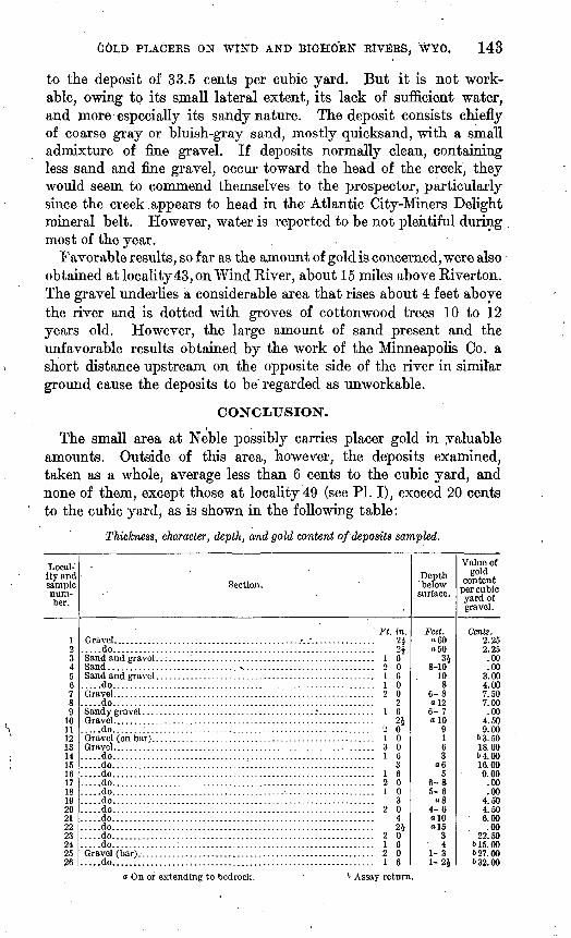
The small area at Neble possibly carries placer gold in valuable amounts. Outside of this area, however, the deposits examined, taken as a whole, average less than 6 cents to the cubic yard, and none of them, except those at locality 49 (see PI. I), exceed 20 cents to the cubic yard, as is shown in the following table:
Thickness, character, depth, and gold content of deposits sampled.
Local ity and sample num ber.
123456789
1011121314151617181920212223242526
Gravel.......................do..................
Sand...................
.....do..................Gravel.......................do..................
Gravel.......................do.......;..........
Gravel.......................do.......................do.......................do.......................do.......................do.......................do.......................do.......................do.......................do.......................do.......................do..................Gravel (bar).-. ...............do..................
Section.
' Ft. in. ........................./.."............... 2J
9A.......................................... 1 6.......... A .............................. 2 0.......................................... 1 6.......................................... 1 0.......................................... 2 0.......................................... 2........................................... I 6
01
.......................................... 2 0
.......................................... 1 0
.......................................... 3 0
.......................................... 1 6
.......................................... 3
.......................................... 1 6
.......................................... 2 0
.......................................... 1 0
.......................................... 3
.......................................... 2 0
.......................................... 491
.......................................... 2 0
.......................................... 1 6
.......................................... 2 0
.......................................... 1 6
Depth ' below surface.
Feet. o60o50
348-10
108
6-8ol26- 7olO
9163
065
6-85-6
084-6olO«15
34
1-31-24
Value of gold
content per cubic yard of 'gravel.
Cents. 2.252.25.00.00
3.004.007.507.00.00
4.509.00
63.5018.0064.0016.009.00
.00
.004.504.506.00
. .0022.50
615.00627.00632.00
o On or extending to bedrock. 6 Assay return.
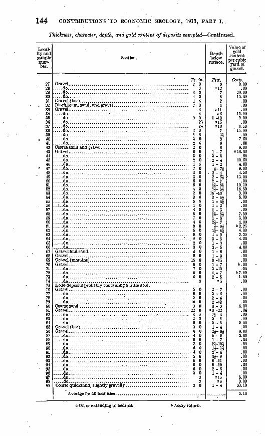
144 CONTRIBUTIONS 'TO ECONOMIC GEOLOGY, 1913, PART I.,
Thickness, character, depth, and gold content of deposits sampled Continued.
Local ity and sample num ber.
2728293031
. 32333*
3536373839
, 40414243444546
- 4748495061£25354555657585960616263646566676869707172737475 7677787980818283848586878889909192OQ
94OK
Qfl
*98QQ
Section.
....do....................................................
....do.........................................................do....................................................Gravel (bar)............ . ....... .....................
Gravel. .......................................................do..................................... ......................do........................................................do........................................................do........................................................do.......................................;................do........................................................do.........................................................do....................................................
Gravel... . .....................................................do.........................................................do.........................................;...............do.........................................................do.....................................:...................do......... ........... ..............^..... :...............do..........................................................do.......................:.................................do.........................................................do.........................................................do.......................................;.................do.........................................................do..........................................................do.......... ..............................................do.........................................................do........... .............................................do.........................................................do.........................................................do.........................................................do.........................................................do.........................................................do.........................................................do.........................................................do.....................................................Gravel and sand. .........................................
Gravel (moraine) .........................................Gravel. ........................................................do.........................................................do.........................................................do.........................................................do...................................................Lode deposits probably containing a little gold. Gravel. . .......................................................do.........................................................do..........................'...............................do....................................................
Gravel... . ........"..............................'...............do.;..,....................................................do.........................................................do...................................;................
Gravel... . .....................'.............................. .do.........................................................do.........................................................do.........................................................do.........................................................do.........................................................do.........................................................do...................... ..................................do.........................................................do............................................... .........do.........................................................do.........................................................do....................................................
Ft. in. 9 n
........ 3
........ 3 0
........ 4 0......... 1 6........ 2 0........ 3
0
........ 9 001
91........ 3 0........ 1 6........ 3 0
......... 2 6........ 2 0......... 6 0......... 3 0......... 2 0......... 1 6......... 7 0......... 2 0......... 36......... 5 0......... 5 0......... 4 0......... 2 0......... 3 6......... 5 6......... 1 0......... 4 0......... 5 0......... 7 0......:.. 4 6......... 9 0......... 5 0......... 8 0......... 2 o......... 2 0......... 3 0......... 5 0......... 8 0......... 15 0......... 6 0......... 7 0......... 6 0......... 6 0........ 3
......... 5 0
......... 6 0
......... 2 0
......... 10 0
......... 3 0
......... 22 0........ 3 6........ 2 0........ 6 0
......... 3 0
......... 6 0
......... 4 0
......... 6 0
......... 8 0
......... 6 0
......... 4 0
.....:... 5 6
......... 5 0
......... 6 0
......... 6 0
......... 3 0
......... 3
......... 3
......... 3 0
Depth below
surface.
Feet. 8
' o!27624
all08
1-10ol5a 10
7si?Q
61 -73-62-41 9i-7l
9 42-5i2-71J-6J11-51
16-183-6i1-6J1-21-51 1 ftli'-s491 71 01
1 1 Rl1*-P
3-51-32 K
1-6i a0-151-73 -101-72-8
o5
2-72-82-42-120-3
aO-222i-60 _ K
2-81-421-815-91-72JH0111-7*2-631-96-119-152-81-4
o!506
1-4
Value of gold
content per cubic yard of gravel.
Cents. 0.00.00
20.0015.00
.00
.00
.0015.009.00.00
4.5015.00
.007.50.00
9.00618.00
.0010.504.009.004.50
15.00.00
10.5018.509.008.00.00.00.00
7.505.004.00
&2.2S4.002.254.50.00
4.00.00.00.00
b..OO.00
&7.501.50.00
.00
.00
.00
.006.00.04.00.00
9.00.00
9.003.00.00.00.00.00.00.00.00.00.00
5.003.00
33.50
5.10
o On or extending to bedrock. b Assay return.

GOLD PLACERS ON WIND AND BIGHORN RIVERS, WYO. 145
Because of their paucity in gold and their excess in sand, especially in heavy sand from which the gold can not be separated by normal placer methods, and because of their consolidated condition, which in some localities necessitates crushing, the deposits are not re garded as workable or as having commercial value.
The facts that the operations of the Shoshoni Gold Dredging Co.'s dredge in the Neble area proved a failure and that, except at the west end, the ground has been prospected only surficially on the recent river bars make it very doubtful whether even this area contains workable deposits. The attention of those who may con template installing a dredge here should be called to the fact that in other placer fields, as at Oroville, Cal., where plants completely equipped with all modern appliances are in operation, similar depos its, though high in gold, are considered nonworkable, owing to their large content of fine heavy sand.