goce, satellite gravimetry and a subjective view on … satellite gravimetry and a subjective view...
TRANSCRIPT

GOCE,
satellite gravimetry
and a subjective view on the role
of satellite laser ranging
Reiner Rummel
Institute of Astronomical and Physical Geodesy
Technische Universität München
International Laserworkshop, Wettzell, 16.5.2011

• first principle of satellite gravimetry
• satellite gravimetry – a short history
• GOCE versus GRACE
• GRACE and GRACE follow-on
• GOCE gravity gradiometry and its sensor system
• GOCE and the role of its orbits
• satellite gravimetry and fundamental physics
How to connect to the theme of this workshop?
• laser tracking of GOCE?
• the connection of geometry and gravity?
• future gravimetric satellite missions and laser technology?
• …

I. Newton “De mundi systemate“ 1715
test mass in free fall
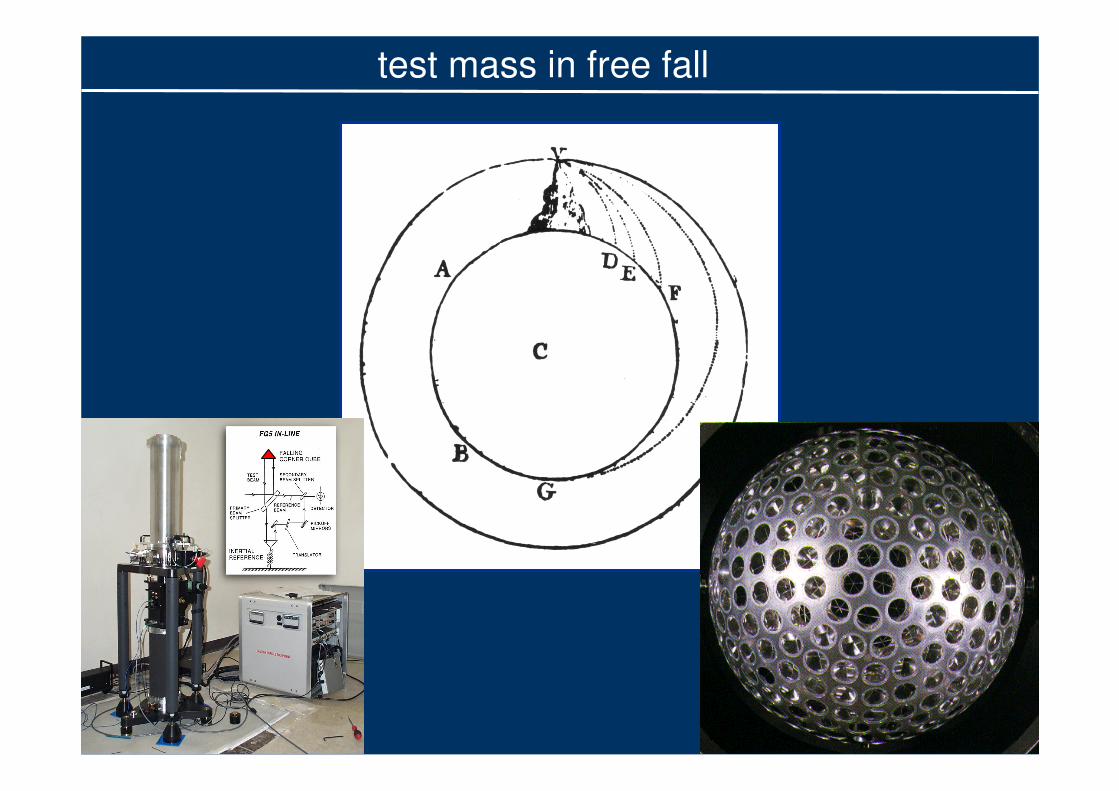
test mass in free fall

1957: Sputnik 1
today: LAGEOS I and II
test mass in free fall

Cox & Chao, Science, 297, 2002
steady decrease of earth flattening
change of trend in recent years
test mass in free fall

Dickey, Marcus, de Viron, Fukumori, 2002
temporal changes of the earth‘s flattening:
what are the causes?
candidates:
ocean masses
melting ice caps
atmospheric masses
hydrology
test mass in free fall

Ciufolini I, A Paolozzi, EC Pavlis, JC Ries, R König, RA Matzner,
G Sindoni, H Neumayer: Towards a One Percent Measurement
of Frame Dragging by Spin with Satellite Laser Ranging to
LAGEOS, LAGEOS 2 and LARES and GRACE Gravity Models
in: Probing the Nature of Gravity by Everitt CWF et al. (eds.) 2010
Ciufolini I: Phys. Rev. Lett. 56, 278–281 (1986)
Measurement of the Lense-Thirring drag on high-altitude,
laser-ranged artificial satellites
Bertotti B: Generation of geodesic motion by the twin probe method, 1974
test mass in free fall
alliance of geodesy and fundamental physics

observatories “see” onlyshort arc segments
test mass in free fall

285
330
400
500
670
1000
2000half w
avele
ngth
[km
]
Slm
← order → Clm
degre
e
EGM96s signal−to−noise spectrum
−60 −40 −20 0 20 40 60
0
10
20
30
40
50
60
70
significant digits0 1 2 3
test mass in free fall
many satellites, many orbit characteristics, many arcs

a new era: 1. uninterrupted tracking in 3D (GNSS)
2. low earth orbiters (LEOs)
3. ultra precise accelerometers
test mass in free fall
satellite-to-satellite tracking in high-low mode

-150 -100 -50 0 50 100 150
-80
-60
-40
-20
0
20
40
60
80
Longitude [°]
Latitu
de [
°]
Geoid height to WGS84 (LMax
= 70)
[m]
-100 -80 -60 -40 -20 0 20 40 60 80
geoid model derived from high-low satellite-to-satellite tracking

several test masses in free fall

from absolute to differential measurement
several test masses in free fall
baseline: 200km
concept:
GRACE

several test masses in free (?) fall
baseline: 50 cm
concept:
GOCE

400 200 130 100 80 65
half wavelength [km]
50 100 150 200 250 30010
−14
10−13
10−12
10−11
10−10
10−9
10−8
spherical harmonic degree
Deg
ree R
MS
SGG
SST − ll
SST − hl
GMs
Kaula
GOCEGOCE: maximum
resolution (s= 100 km)
GRACEGRACE: maximum
precision (geoid < µm)
GOCE versus GRACE

Degree
Me
an
Sig
na
lp
er
De
gre
e/
De
gre
eE
rro
rM
ed
ian
50 100 150 200
10-12
10-11
10-10
10-9
10-8
10-7
10-6
Mean Signal QL GOCE Model
Mean Signal Kaula Rule
Error Median QL GOCE Model
Error Median EIGEN-5S
Error Median EIGEN-5C
GOCE versus GRACE
degree variances (median) of signal and noise
temporal variations

285
330
400
500
670
1000
2000half w
avele
ngth
[km
]
Slm
← order → Clm
degre
e
EGM96s signal−to−noise spectrum
−60 −40 −20 0 20 40 60
0
10
20
30
40
50
60
70
significant digits0 1 2 3
GOCE versus GRACE
problem with degree/order zero, one, two and low harmonics

Tapley et al., Science, 2004
GRACE measures temporal gravitational changes
example: seasonal changes of continental hydrology
GOCE versus GRACE
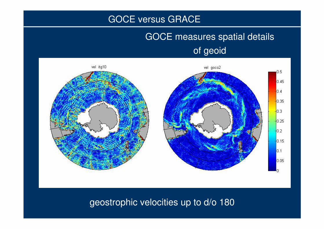
geostrophic velocities up to d/o 180
GOCE versus GRACE
GOCE measures spatial details
of geoid

the future
see also, e.g.:
Bender PL, RS Nerem, JM Wahr: possible future use of
laser gravity gradiometers, Space Sci Rev 108, 2003

the future
Watkins, M, 2007
„how to make use of very high precision?“

GOCEGOCE
GGravity and steady-state
OOcean CCirculation
EExplorer
launched on 17 March 2009
first mission of
“Living Planet Programme”
of ESA
GOCE

GOCEGOCE
• inclination 96 degrees
(sun synchronous)
• circular orbit
• altitude 259 km
• duration > 18 months
mission objectives:
• spatial details (100km)
• gravity to 1 ppm
• geoid 1-2-cm
GOCE

single accelerometer
one axisgradiometer
three axesgradiometer
consisting of
6 accelerometers
GOCE gravitational gradiometry

ion thrusters
ion thruster
control unit
nitrogen tankxenon tank
gravitational
gradiometer
star sensor
GPS receiver
magneto-torquers
power supply
control unit
source: ESA
GOCE sensor system

orbit and gravity field determination from GPS
independent control via satellite laser ranging (SLR)
newly developed
European
space qualifiedGPS receiver
laser
retro-reflectors
GOCE sensor concept

comparison with satellite laser ranging
GOCE orbits

RMS differences 2cm
GOCE orbits

orbit validation with SLR
Jäggi et al., 2010
GOCE orbits
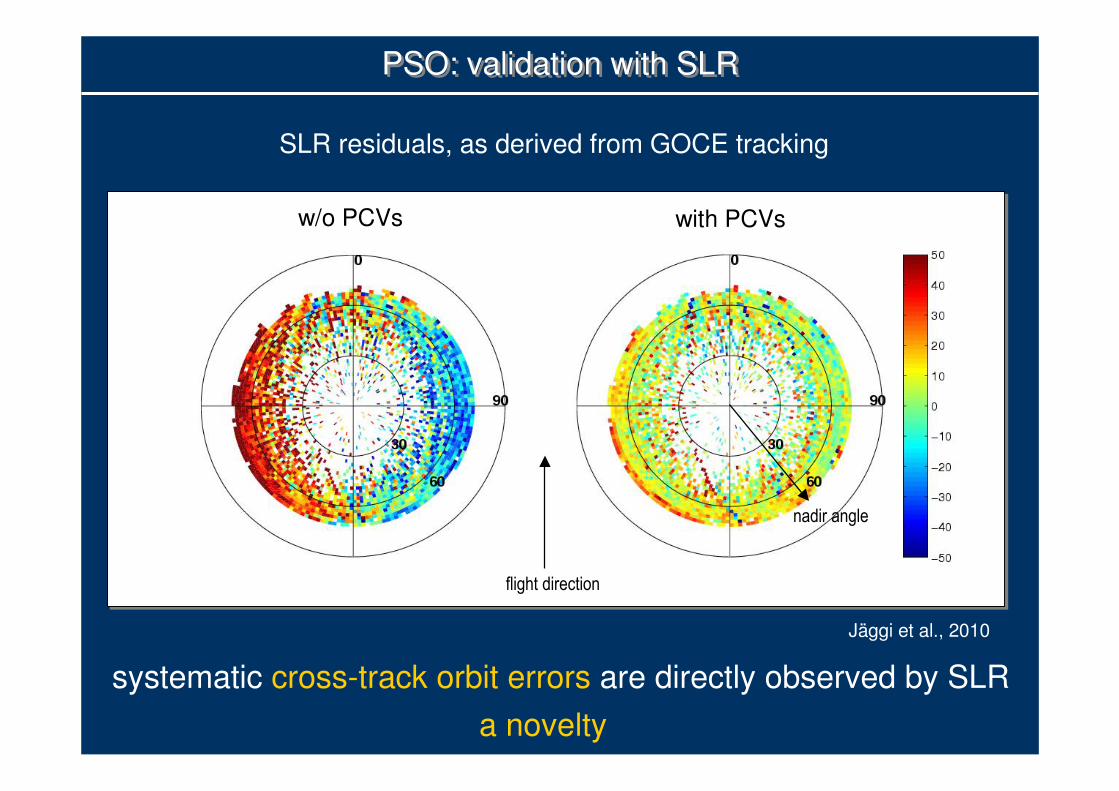
PSO: validation with SLRPSO: validation with SLR
w/o PCVs with PCVs
systematic cross-track orbit errors are directly observed by SLR
a novelty
SLR residuals, as derived from GOCE tracking
flight direction
nadir angle
Jäggi et al., 2010

mean sea surface
1992- 2010
from multi mission
radar altimetry
geoid
from six months
GOCE data
GOCE and oceanography

mean ocean topography (in m)
Gulf stream
ACC
Kuroshio
IAPG/ TUM
GOCE and oceanography

90oW
80oW
70oW 60oW
50oW
24 oN
30 oN
36 oN
42 oN
48oN
Min = 0.065; Max = 104.991;Mean= 11.668; RMS = 11.020
[cm/s]0
10
20
30
40
50
60
70
geostrophic velocities North Atlantic
from GOCE and satellite altimetry
GOCE and oceanography
IAPG/ TUM

Vzz-component from two months GOCE
GOCE and geophysics
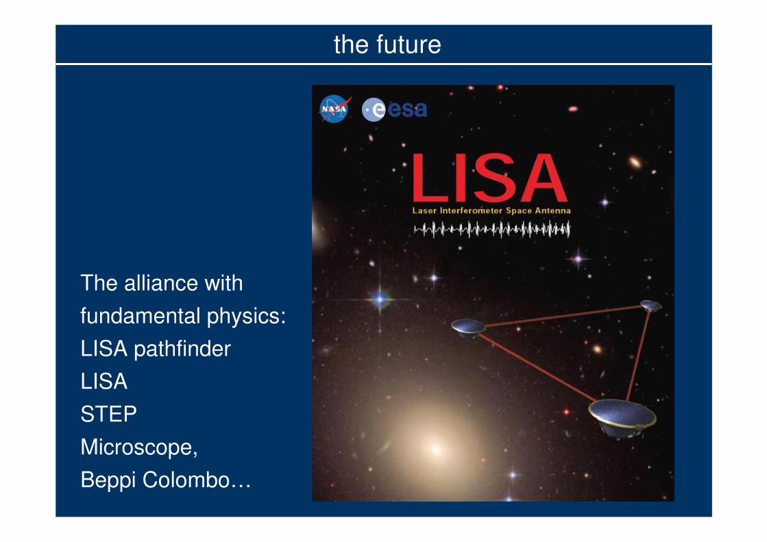
the future
The alliance with
fundamental physics:
LISA pathfinder
LISA
STEP
Microscope,
Beppi Colombo…

The story of two ants walking
on an apple:
“They walk from two adjacent
points A und B,
each taking the shortest distance,
to two adjacent points A’ und B’.
We measure the distance
between them, while they are
walking.
From the measured distances
we derive the local curvature
of the apple”
Geodesic
[Misner, Thorne & Wheeler, 1973]
the future
gravity is geometry
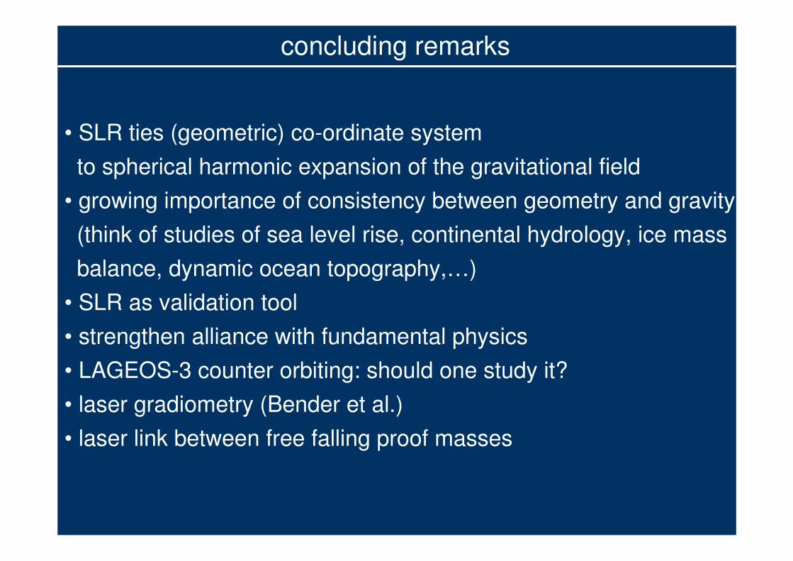
concluding remarks
• SLR ties (geometric) co-ordinate system
to spherical harmonic expansion of the gravitational field
• growing importance of consistency between geometry and gravity
(think of studies of sea level rise, continental hydrology, ice mass
balance, dynamic ocean topography,…)
• SLR as validation tool
• strengthen alliance with fundamental physics
• LAGEOS-3 counter orbiting: should one study it?
• laser gradiometry (Bender et al.)
• laser link between free falling proof masses


Level 2 processing: High Level Processing Facility (HPF)


Ω
ΩΩ
ijIM
CONTROLM
× r
Attitude Control
C o Ma
+
−
+
Aacc
A B +
−
−
∆ x
Bacc
A
C O M D IF
ANTI
a
&ΩV + Ω Ω
+
S
SYM M
C o MX
−
x axis−
GRADIOM ETER
S T A R
S E N S O RGPS
Drag
Control
−
∫Ωdt&
Ω
( & )Ω Ω Ω ∆+ r
NON GRAVFCONTROLF G X( )
GOCEGOCE End-to-End Simulation Scheme