gis mobile apps for rapdrp project for study report.docx
TRANSCRIPT
Discuss the following points:
1. Accuracy / Resolution of lat-long data captured by mobiles with comparison to mobile mapper 10?
2. Cost comparison of available devices and softwares?3. Ability to edit in mobiles, possible or not?4. Automatic upload of mobile data in to web app?
GISMobile Apps for RAPDRP PROJECT
Abstract
Introduction/Executive Summary
The aim of this paper is to identify how GIS mobile APPS technologies and ARCGIS applications have been used, independently as well as in combination, for improving accuracy of geographical position of electrical asset, capturing the data along with mandatory attribute field through mobile apps which incorporated with ARCGIS SERVER web application
Background
The mobility of mobile devices has made it possible to develop and use maps and map based applications for capturing data and navigation purposes.A growing electrical asset of APEPDCL in geographical field needs to employ mobile apps technologies and geographic information systems (GIS) for incremental data capture at field location along with mandatory attribute field and how two types ofsystem i.e. GIS mobile apps and ARCGIS web application systems are integrated together into the information infrastructure of an organization so as to provide a basis for data analysis and decision support. Integration of data and technical systems across the organization is necessary for efficient large-scale implementation.
Outline of project
Creating new feature in gis mobile apps

Mandatory attributes to be provided before saving the edits:
HT Lines, LT lines : Conductor Size, Conductor Type
DTR : Capacity, DTR Structure Code, Rated KVA
Service Connection : Customer Index Number, Power Factor, Sanctioned Load
Meter : Serial Number
Editing the existing attribute field of feature
Training should given for usage of GIS mobile apps
Methodology
The work shall involve GIS mobile apps for finding latitude-longitude of APEPDCL’s network entities and land base features, entity data collection and geo-coding uniquely indexing each customer based on the electrical system network information. This would also facilitate development of digitization of structural, network, consumer data collected by using GIS mobile apps which incorporated ARCGIS web application.
Conclusion
1) HTLine, LTLine,substations, feeders etc. can be created through web applications2) Electrical Assets surveyed by mobile app are viewed over Google Map and
editing/correction of structural,network feature can be done through web application

1. Accuracy / Resolution of lat-long data captured by mobiles with comparison to mobile mapper 10?
Using android phone to plot GPS points?I was wondering if I could use my android phone (HTC Wildfire) to plot gps points and export these into GIS software (I have QGIS and MapInfo)
6
There are a lot of options for collecting GPS point information on Android; I'm experimenting with several of them but none work terribly well - my use case is a bit tough, though, as I'm working out of low-flying Cessna aircraft and need constant GPS positions and to be able to instantly record a correct GPS position together with a note.
OpenDataKit : lets you build custom forms, including taking GPS position (using last-known, network or GPS based), and save to offline database.
GeoPaparazzi : Good for taking notes, either as text, photo or audio. Has a lot of potential, exports to KML and GPX. Won't work if the GPS signal is lost.
GPS Essentials : Good for taking quick text notes, exporting to KML, GPX. Will let you take a note using the last known position, too, instead of waiting for a GPS position.
OSMAnd+ : great for building your own custom maps, or downloading and caching online data, but waypoint creation is not very fast or accurate. It does work with GPX files (import & save).
QGIS on Android : difficult to edit waypoints on the go, especially considering instability of the app at present.
Evernote : when entering a note (text or photo), you can attach a map position, but this doesn't seem to be saved consistently, and there's little chance to export data in a nice GPX or other spatial format.
The inbuilt GPSs in Android phones and tablets tend to drop signal a lot - this is a real problem when the sky is partly blocked (i.e. in a light aircraft), and many apps don't let you just take a note/waypoint using the last known position, so you wait for it to reconnect.
Some apps (I'm looking at you, OSMAnd) will lose GPS signal if the tablet is rotated. Test carefully before doing fieldwork!
You can try the Geopaparazzi app. It has the following features: georeferenced notes
georeferenced and orientated pictures
gps tracks logging
easy export of collected data
a map view for the navigation of the environment

Data can be exported into the following formats
gpx
kmz
geopaparazzi cloud projects
bookmarks
Exports KML or GPX - import to QGIS/Mapinfo"The Swiss army knife of GPS navigation!
The most complete GPS tool on market: Navigate, manage waypoints, tracks, routes, build your own dashboard from 45 widgets.
Dashboard Shows navigation values such as: Accuracy, Altitude, Speed, Battery, Bearing, Climb, Course, Date, Declination, Distance, ETA, Latitude, Longitude, Max Speed, Min Speed, Actual Speed, True Speed,
Sunrise, Sunset, Moonset, Moonrise, Moon Phase, Target, Time, TTG, Turn.
Compass Show the orientation of the earth's magnetic field, shows an arbitrary tracking angle and the current target. Also a marine orienteering compass.
Tracks Record tracks and view them on map. Export KML files and import into Google Maps, Google Earth and others.
Routes Manage routes and view them on map. Import KML files from Google Maps, Google Earth and others. Create turn-by-turn instructions between waypoints.
Camera A camera HUD (heads-up display) view to show your waypoints, take pictures and share them.
Map A map to show your waypoints. Convert mail addresses of your contacts to waypoint so that they can be used within the app.
Supports Google Maps, MapQuest, OpenStreetMap and others.
Waypoints A list of all your waypoints with export and import (KML and GPX format).
Satellites A sky view of the current positions that shows satellites in view.
Features Supported position formats: UTM, MGRS, OSGB, Degree-Minute-Second, Degree-Minute-Fractions, Decimal. Supports over 230 datums.
Waypoints, routes and tracks can be exported as KML or GPX files and sent by email or uploaded to Google Docs or DropBox.
Please open the web page below for more info, send me emails for support. I CANNOT HELP IF YOU SIMPLY PLACE A COMMENT HERE.
Purchase the "GPS Essentials Donation Plugin" on Android Market if you want to support development.
The latest beta release is available at http://www.gpsessentials.com for download. Try out the latest features and help us improve GPS Essentials!If you are on Facebook, come and join GPS Essentials for the latest info:http://www.gpsessentials.comTHIS APP WILL SHOW ADVERTISING. IF YOU DON'T LIKE THIS, PLEASE REFRAIN FROM INSTALLING/UPDATING.
GPS Essentials is not affiliated with any political party nor with any other organization mentioned in the ads, and it has no connection with any economic interests. If you don't like the ads, please contact AdMob.
WHAT ARE THE PERMISSIONS GOOD FOR?
✓ Coarse/Fine location: To access network locations and GPS ✓ Full internet access: To read map tiles, send bug reports ✓ Modify/delete USB storage contents: To write waypoints, tracks and images onto the SD card ✓ Read phone state and identity: To tag pictures with the device ID (can be switched off in settings) ✓ Take pictures and videos: Camera HUD, take pictures "https://play.google.com/store/apps/details?id=com.mictale.gpsessentials&hl=en

I love this one, it's the best GPS app I have found so far on android. Not quite as good as the one I had on WebOS (but i can't remember the name anymore), though... – SAnderka Oct 24 '12 at 11:48
add a comment
I'll add my own app here for completeness sake (although I may be biased :) ):
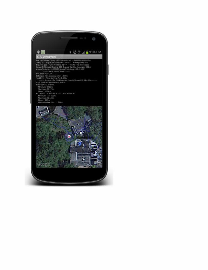
GPS BenchmarkIt's the only app on Google Play that automatically compares a user-entered ground truth location to GPS data from the mobile device to calculate true accuracy of the GPS. Other apps will only show theestimated location error that is calculated by the device, which (as GPS Benchmark shows) can be far from accurate.While setting a ground truth location via tapping on the map is convenient, it can be limiting in terms of accuracy and precision. The app also supports typing in a known ground truth location lat/long/alt, which bypasses any potential map issues. To make manual entry less cumbersome, it also supports capturing a "geo:"-encoded location from a QR Code (encoded with a QR Code generator such as ZXing) or NFC tag, which can be written using any NFC tag reader (including an option in GPS Benchmark to write the current ground truth location to an NFC tag).GPS Benchmark exports the data as well as the results to KML and CSV formats, which are both compatible with ArcGIS products, as well as other GIS products.
The first image below is a screenshot of the GPS Benchmark app collecting data and calculating true error, and the second image is a screenshot of the results (green = 95th percentile, yellow is 68th percentile, and red is 50th percentile of horizontal error) being visualized in Google Earth.
Link on Google Play:
https://play.google.com/store/apps/details?id=com.gpsbenchmark.androidI hope its useful!
2
Checking the accuracy of a GPS by assuming that you can select the "correct" point off of a google maps image is misleading. In many areas, google maps itself is off by tens of metres, let alone the inaccuracy of choosing a point on a small touchscreen from an image with (often) poor resolution to begin with. – Simbamangu Oct 24 '12 at 3:22
1 There is often even an offset of 2-3 m between map view and satellite view - and I'm talking about southern Germany here, not some far away place with poor data quality... – SAnderka Oct 24 '12 at 11:46
@Simbamangu Agreed, setting a ground truth location via tapping on the map can be limiting in terms of accuracy and precision. The app also supports typing in a known ground truth location lat/long/alt, which bypasses any map issues. To make manual entry less cumbersome, it also supports capturing a "geo:"-encoded location from a QR Code (encoded with a QR Code generator such as Zxing) or NFC tag, which can be written using any NFC tag reader. These options, of course, assume a known ground truth location by the user. I'll update the post to reflect these issues. – Sean Barbeau Oct 24 '12 at 13:17
Nice app, but Menu button/access does not work on Android 5. – Carsten Schütte Jun 21 at 7:45

@Carsten Thanks! For newer Android devices/versions without a menu button, just press and hold the Multitasking button that is next to the Home button. It should bring up the menu. I need to overhaul GPS Benchmark to include Action Bar, etc., but I just haven't gotten around to it. – Sean Barbeau Jun 21 at
How to capture accurate GPS points using mobile devices?
up
vot
e6dow
n votefavorite
1
I'm currently working in Vietnam as a climbing guide, but am putting my GIS skills to use by doing a side project for the company involving the mapping of climbing routes. Along with another employee who is an app developer, our goal is produce a digital guidebook for the area.
For this project to work for me, I need to be able to take fairly accurate GPS points, as there are features just a few meters ap[art from each other that need to be distinguishable, but obviously survey grade equipment is not and option for me here. I've been using the app GPS Averaging to take several hundred points for each location.Despite taking these averages, I'm having very little luck achieving accuracy in my output points, and I suspect my precision is low as well because the in app reported error gets very low (0.8m) after about 20 collected points, then goes up to about 3m after 200-300 collected points. However when I import these points, the actual errors appear to be well beyond 3 meters.
What can I do to improve GPS point accuracy from a mobile device? Any suggestions would be hugely appreciated. I've currently only worked on this with android devices, but have access to ios devices too if they provide superior GPS chips.
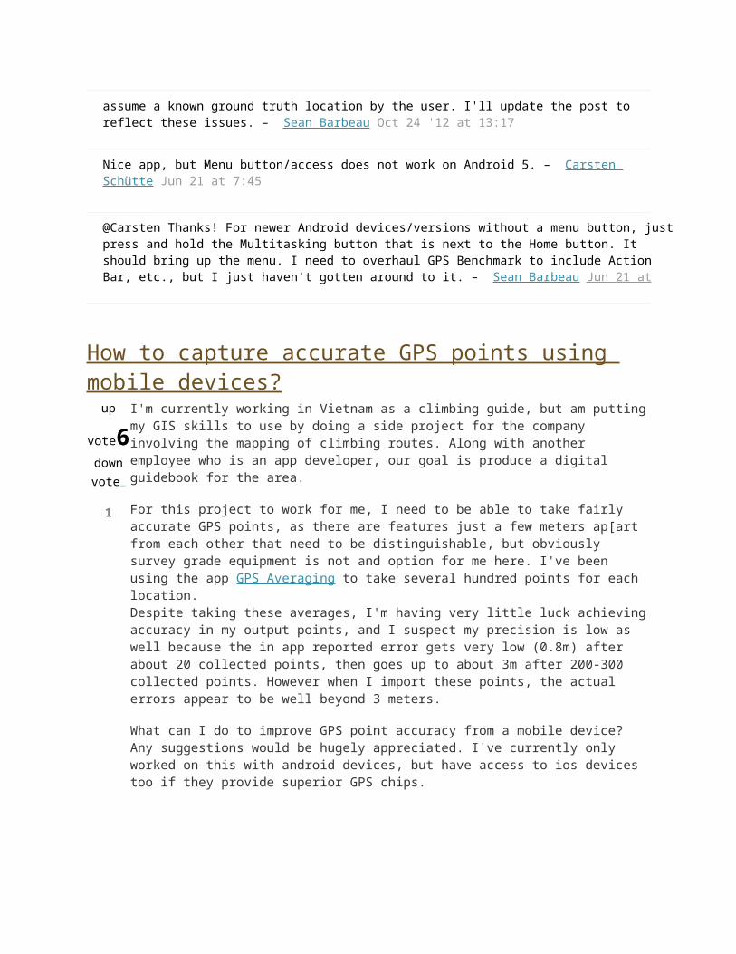
I've done exactly the same thing for the same purposes - creating GIS-based rock climbing guides using GPS points taken with a mobile phone. I collected my points using an iPhone and the iGIS app. What I liked about iGIS was its ability to read/write directly to shapefiles, so you can get your attribute schema all setup outside of the app.
Screenshot of some climbing route points that were collected:
As far as improving the accuracy of taking GPS points under cliffs and in tree cover - there's not
alot you can do (especially using a phone). Speaking from personal experience, even a survey-grade RTK GPS unit struggles under these conditions to get a lock sufficient for taking high accuracy locations. This is due to interference and obstruction of the signals the unit is trying to reconcile to produce accurate point solutions.
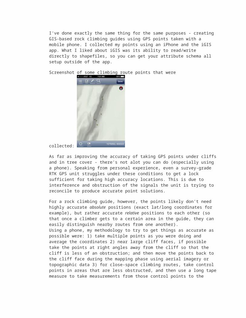
For a rock climbing guide, however, the points likely don't need highly accurate absolute positions (exact lat/long coordinates for example), but rather accurate relative positions to each other (so that once a climber gets to a certain area in the guide, they can easily distinguish nearby routes from one another).Using a phone, my methodology to try to get things as accurate as possible were: 1) take multiple points as you were doing and average the coordinates 2) near large cliff faces, if possible take the points at right angles away from the cliff so that the cliff is less of an obstruction; and then move the points back to the cliff face during the mapping phase using aerial imagery or topographic data 3) for close-space climbing routes, take control points in areas that are less obstructed, and then use a long tape measure to take measurements from those control points to the routes; then map the points using your sketches later
A sample of the finished guide:
In this case you might be more precise if you fine tune your points on a computer later. For example try to note the position of the point relatively to a tree or any other significant feature in the landscape.
Anyway, even if you position your point perfectly at the right place, it is very likely that the user of your guide won't have a better GPS than yours. It would hence be a kind of "overkill" to locate your
point at a < m precision if nobody will use a device with that precision to find them.
Finally, and this is in the same direction as #mpianka above, it is more important to locate your points correctly relatively to each other rather than absolutely on a geodesic system.
It may not be your gps readings. The map base is unlikely to be as accurate as your readings. You are probably/possibly experiencing the difference between absolute position and relative/cartographic/ortho position. Unless the area you are surveying has been mapped to high accuracy putting your position on it may well appear innaccurate.
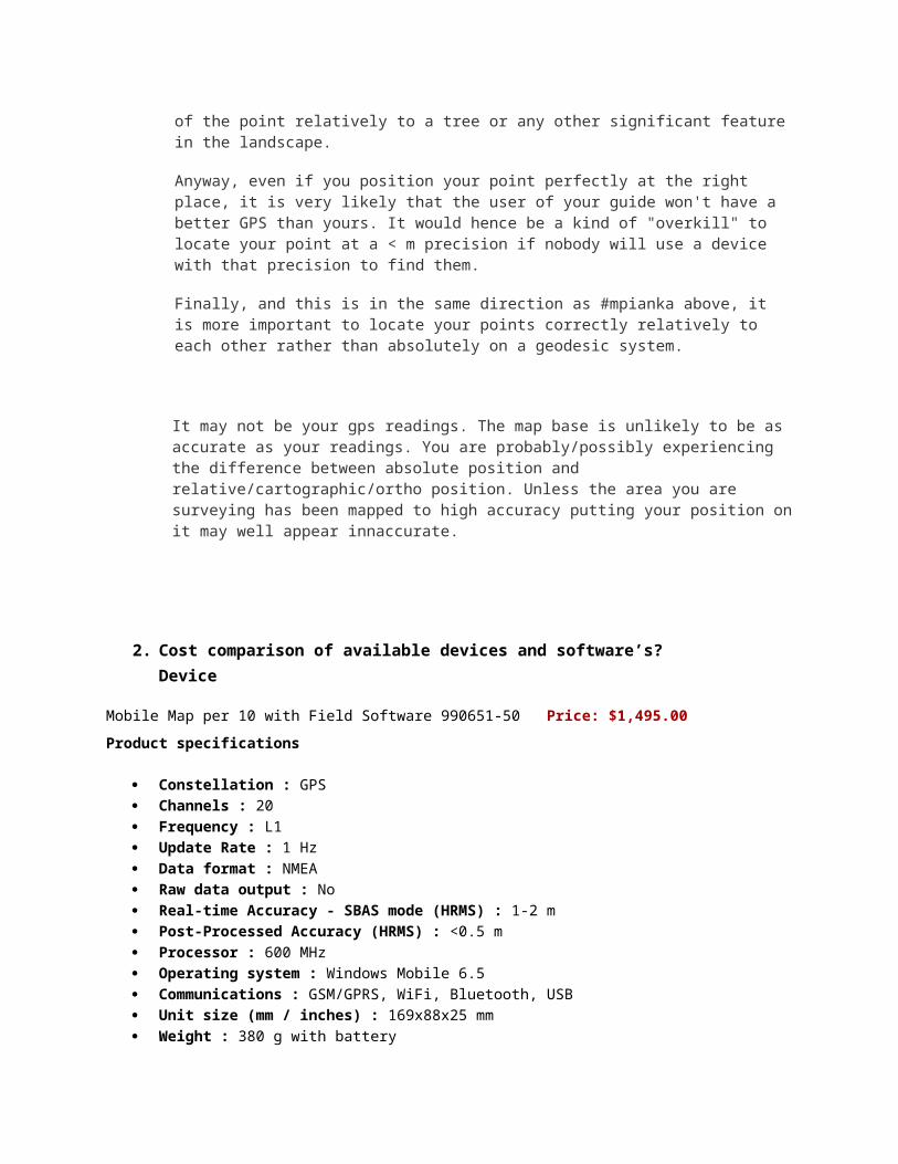
2. Cost comparison of available devices and software’s?Device
Mobile Map per 10 with Field Software 990651-50 Price: $1,495.00
Product specifications
Constellation : GPS Channels : 20 Frequency : L1 Update Rate : 1 Hz Data format : NMEA Raw data output : No Real-time Accuracy - SBAS mode (HRMS) : 1-2 m Post-Processed Accuracy (HRMS) : <0.5 m Processor : 600 MHz Operating system : Windows Mobile 6.5 Communications : GSM/GPRS, WiFi, Bluetooth, USB Unit size (mm / inches) : 169x88x25 mm Weight : 380 g with battery Display : 3.5 Memory : 128MB SDRAM, 256 MB Flash, Micro SDHC (up to 8GB) Temp Min (?C) : -10?C Temp Max (?C) : +60?C Waterproof : IP54 Shock & vibration : 1,2 m drop Power (type - lifetime) : LiIon, 3000mAh, > 20 hours Antenna Type : Internal / External Firmware options : No Software options : Yes
MobileMapper 20 Notes
The MobileMapper 20 is the 2014 model of the MobileMapper 10. The MM20 has some great improvements: bright full VGA screen size, higher resolution camera, more internal memory...
MobileMapper 20
GPS Sirf III + post processing20 channels GPS + SBAS
Tracking L1, CA Code
Accuracy (SBAS open sky) 1-2 m real time<0.5 m post-processing
CPU (MHz) 600
Windows Mobile Microsoft® Windows Embedded Handheld 6.5
Flash (MB) 256
RAM (MB) 128
Size (mm) Weight (g) 166x86x30, 380g
Display 3.5’ VGA
USB Yes
WiFi / BT Y/Y
Cellular GSM/GPRS/HSPA 3.5G
Memory card Micro SD up to 32 GB
Drop 1.2 m
IP rate IP54
Operating temperature -10 to +60°C
Sensors 5M Camera, e compass g sensor
Battery life > 20 hours !!!
Interface USB, Standard Cable!
Post-processing Yes, Ashtech BLADE

The MobileMapper 20 battery pack is an inexpensive, custom Li-Ion rechargeable pack:
<click to enlarge
It is easy to add additional memory to the MobileMapper 20 using the MicroSD card slot under the battery. The SIM card slot for GSM activation is under the battery also:
<click to enlarge
SiRFstarIII (see CSR) based GPS engine results in quick autonomous fixes, < 35 seconds. This engine boasts 20 channel tracking and 200,000+ correlators for fast TTFF and high-sensitivity acquisition under heavy canopy and in urban environments. The MobileMapper 10 has an enhanced GPS antenna and LNA front end which provides even better operation than the MobileMapper 6 receiver.
Coupled with proprietary Ashtech's BLADETM Processing, the MobileMapper 10 enjoys sub-meter accuracy in the USA with WAAS. (Accuracy results other locales with alternate SBAS corrections are different.)
Comparable Products Ashtech MobileMapper 120 The most obvious comparable product is the Ashtech MobileMapper 100 (the
'big brother' of the MM10):
MobileMapper 10 MobileMapper 120
CPU (MHz) 600 806
GNSS Sirf III20-Channel GPS + WAAS
GPS L1/L2, GLO L1Ashtech GNSS
RTK
Accuracy in the USA
Sub Meter Real Time (SBAS)0.2 Meter Post-Processed
0.5 Meter Real Time1 cm RTK / Post
Processed
Windows Mobile
Microsoft® Windows Embedded Handheld 6.5
Microsoft® Windows Embedded Handheld 6.5
Flash (MB) 512 2 GB
RAM (MB) 256 256
Size (mm) 169x86x30 190x87x42
Display 3.5’ VGA 3.5’ QVGA
WiFi / BT Yes / Yes External SDIO / Yes
Cellular GSM/GPRS/HSPA 3.5G yes
Camera 3M, AF 3M, AF
Memory card micro SD SDHC
Drop Rating IP54 IP65
Price $1,195 (base) $3,295 (base)
Gis mobile apps software
E-PoleSurvey
Description
e-Pole Survey Application is developed by EnerComp Solutions Pvt Ltd to support easy updation of
GIS Survey data in Electricity Distribution Utility. In India lot of money has been spent for GIS centric
IT system under RAPDRP. However, regular updation of GIS data initially captured is not done. An
attempt is made here to resolve such issues utilizing GPS capabilities of Android Smart Phone as a
survey device. Further a web application is developed to display surveyed data on Google Map
Layer and features for verification of surveyed data before export to GIS application is provided.
Major features of e-Pole Survey Application are as listed below:
- Use of Android Smart Phone to GPS survey electricity distribution network including capturing
asset attributes
-Dynamic addition / alteration in number and details of attributes to be captured from web application
-Smart Phone authentication by IMEI and Password
-Real-time data transfer to server through GPRS
-Facility to download feeder data from server for field verification by Smart Phone using Android App
-Office hierarchy and user access control as per work area
-Asset attributes can be added or modified from web application and be added in mobile app
dynamically
-Electrical Assets surveyed by mobile app are viewed over Google Map and editing/correction of
location can be done through web application
-New offices, substations, feeders etc. can be created through web applications
Log in to web application using username : superadmin, password : superadmin on
linkhttp://demo.enercomp.in/ePoleSurvey/
We appreciate your feedback and suggestions on email id [email protected]

Mobile Data Collection
GIS Cloud Mobile Data Collection is a tool for web and mobile devices which allows you to collect data in real time, with custom designed forms, work in offline mode and more.Collect field data and conduct field surveys faster and easier than ever before.
Simply sign in with your GIS Cloud account (or sign up for free) and send collected data directly to
your GIS Cloud app in the cloud.
You can customize your data forms to include photos and audio as well as standard text, number, or
choice inputs.
Couple this mobile app with the MDC Portal web app on http://mdc.giscloud.com and have your
team out and about in a quarter of an hour!
GIS Cloud, powerful next-generation cloud solutions that manage geo-located assets and
information.
All you need in the field:
- Offline data capture
- Media (photos & audio) enriched location information
- QR code and barcode support
- Dropdowns, lists, input boxes and comments based on custom forms
- Review data attributes directly in the app
- Edit existing data
- Listen to audio and view images
- Real time GPS location
- View and explore maps in the field
What is Mappt?Mappt is an agile data capture and management tool used on Android tablet devices providing you flexibility and interoperability for your core Geodata.
Using Mappt allows you to be in the field working with your information in a matter of hours. Its friendly user interface and smart functionality allows you to create, edit, store and share spatial information while disconnected from your corporate systems.
Compatible with leading GIS standards, Mappt can be used for Geology, Mining, Asset Management, Oil and Gas, Environment Management and Emergency Response. Using Mappt you can also benefit from:

No monthly service charge or cloud based service lock-in.
Fast, simple & accurate field data processing with your own data.
Functionality such as GPS tracking, load ECW and JP2 custom imagery and thematic mapping giving you more than just simple create and edit tools.
Mappt is a low cost, high value solution that compliments your GIS data management workflow.
Download the Brochure
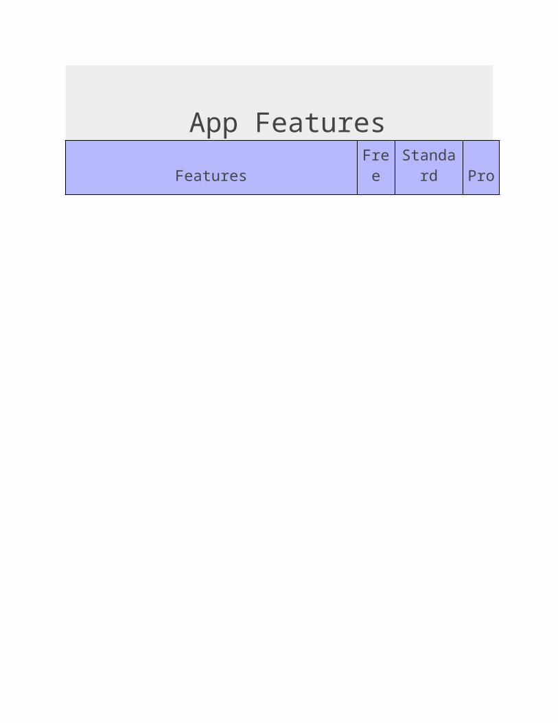
App FeaturesFeatures Free Standard Pro
Create and edit Points, Lines and Polygon data and take notes.
Add new or modify existing data attributes.
Import vector data (SHP, KML and KMZ).
Measurement tools (distance, area, etc).
Advanced map caching, allowing you to work offline.
Projection control.
Import existing data from the file system, via HTTP or Google Drive.
Export data as KML or Shapefile to the file system or as an email attachment.
Geofence exclusion and inclusion zones. Create 'invisible' fences with warnings and automatic incident data.
GPS tracking and background GPS Path creation.
Thematic mapping (data classification).
Prioritised Support.
ECW and JP2 imagery.Up to 1
Gigapixel
Up to 1
Gigapix
el
3. Ability to edit in mobiles, possible or not?If live data of rapdp gis application is access through gis mobile apps
Editing of existing attribute fields of feature is possible
Some structural feature of the electrical asset are place using lat-long ( x, y coordinates)Ex placing pole
Line, Polyline, feature i.e HTline, LTline DTR, Composite feature captured through web application
4. Automatic upload of mobile data in to web app? Is GIS mobile apps is integrated with arc gis web application whether it supports or not?
If it is supports or access to the RAPDRP GIS APPLICATION through gis mobiles apps all existing data i.e electrical network and land base feature should resemble in gis mobile application
We need to develop interface between the arc gis web application and gis mobile apps, so that we can collected survey field data of electrical network asset such as point feature can be placed by using Lat-Long ( x, y coordinates) in gis mobile apps, where has Line, Polyline and composite feature should capture using web application
Due the complexity of web application and spatial database access of rapdrp gis application through gis mobile apps is not feasible because of mobile configuration may not support