geotourism potential of underground sites in costa rica
TRANSCRIPT

Ulloa & Goicoechea. Geotourism potential of underground sites in Costa Rica.
Campinas, SeTur/SBE. Tourism and Karst Areas, 6(1), 2013.
43
GEOTOURISM POTENTIAL OF UNDERGROUND SITES IN COSTA RICA
POTENCIAL GEOTURÍSTICO DE LUGARES SUBTERRÂNEOS NA COSTA RICA
Andrés Ulloa (1,2) & Carlos Goicoechea (1)
(1) Grupo Espeleológico Anthros (GEA) – San José, Costa Rica.
(2) Centro de Investigaciones en Ciencias Geológicas, Universidad de Costa Rica (CICG) – San José, Costa
Rica.
E-mail: [email protected]; [email protected]
Abstract
Although tourism is presently the main source of income of the Republic of Costa Rica, making an analysis
of the offer and demand of the topic of "underground sites as tourist attractions", it is evident that in our
country this activity is minimal, with percentage figures that are not even taken into account in the statistics.
At government level, there's only one National Park whose focus is caves (Barra Honda); in this aspect,
there's also very little and ambiguous legislation. At a private enterprise level, there are only five karstic
underground sites worthy of mention, of which only two can qualify as 'business operations'. The other 3 are
underground sites to which occasionally and informal visits are launched, but it is still difficult to find
references, even in the web.
Key-Words: Caves; Underground tourist; Karst; Limestone; Tunnels, Costa Rica.
Resumo
Embora o turismo seja atualmente a principal fonte de renda da República da Costa Rica, fazendo uma
análise da oferta e da demanda do tema de "lugares subterrâneos como atrações turísticas", é evidente para
os autores que na Costa Rica esta atividade é mínima, com percentuais que não são sequer tidos em conta
nas estatísticas. No âmbito governamental, só há um parque nacional cujo foco é cavernas (Barra Honda).
Neste aspecto, há também pouca legislação, e também ambígua. Ao nível privado, há apenas cinco lugares
subterrâneos cársticos dignos de referência, dos quais apenas dois podem ser qualificados como operações
comerciais. Os outros três são lugares subterrâneos com visitas ocasionais e informais, sobre as quais ainda
é difícil encontrar referências, mesmo na rede mundial.
Palavras-Chave: Cavernas; Turismo subterrâneo; Carste; Calcário; Túneis, Costa Rica.
1. INTRODUCTION
Costa Rica, despite its small land area (51,100
km2) offers great biological and geological diversity,
presenting attractions such as active volcanoes,
sandy beaches, waterfalls, reefs, islands, caves and
mine tunnels. Some of these attractions are quite
exploited by tourism in general (i.e., volcanoes and
sandy beaches), others as “adventure tourism” (i.e.,
caves), while others are potentially exploitable for
rural tourism (i.e., mine tunnels). This article focuses
on the underground tourist attractions (caves and
tunnels) that are currently exploited or could be
exploited in the future, which may have a high
scenic, geological, historical or educational value.
One of the main economic activities in Costa
Rica is tourism, reaching 9,1% of the Gross National
Product during 2012 (La Nación, 2013). Tourists
who come to Costa Rica are looking mainly for
adventure, ecological and nature tourism. Although
many of the country's tourist attractions have strong
geological component (i.e., Poás, Irazú, Rincón de la
Vieja volcanoes), it is considered that there is
insufficient information available as to geotourism
in the country and very few studies have addressed
these issues (Campos; Astorga, 2010; Ulloa et al.,
2011; Bundschuh et al., 2007).
The first National Park in Costa Rica (Poás
Volcano National Park) was created in 1971 and
since then, gradually an extensive protection system
has been established, initially and fundamentally for
the protection and conservation of the unique
biodiversity that characterizes this small country.
Afterwards, the option of making the Parks
available to tourism aroused an activity that, in this
specific aspect, still continues to be a function of
second instance. According to the National Institute
for Biodiversity today approximately 25,1% of the
territory of Costa Rica consists of National Parks,

Ulloa & Goicoechea. Geotourism potential of underground sites in Costa Rica.
Campinas, SeTur/SBE. Tourism and Karst Areas, 6(1), 2013.
44
Biological and/or Forest Reserves, Wetlands and
other forms of protection, including two parks
declared "World Heritage" by UNESCO. Forty four
percent (44%) of that total is in the hands of private
enterprises, especially in categories such as buffer
zones, forest reserves and refuges. For its better
management, 11 Protected Areas have been
established, which break down to 162 Protected
Areas (INBIO, 2013).
1.1. General geological aspects
Costa Rica corresponds to an island-arc
caused by subduction, a phenomenon that occurs
since the Upper Cretaceous. The recent volcanic arc
has a NW-SE axis, with active volcanoes from the
North part of Costa Rica to the Turrialba volcano.
Between Turrialba and Barú (in Panama) volcanoes
exists a gap in the recent volcanic activity; these area
corresponds to the Talamanca Range. Also Tertiary
volcanism is present (Aguacate Group, Sarapiquí
Formation), that presents some ore, with presence
mainly of gold and silver (figure 1). These
mineralizations has been exploited (principally as
underground mining) since colonial times (Ulloa,
1979).
During the geological evolution, different
episodes of carbonate deposition have presented in
the forearc, intra-arc and back-arc basins, which led
to the deposition of limestone from the Cretaceous
to Recent (Figure 1), in which karst occurs (Ulloa et
al., 2011).
This geological diversity present in Costa
Rica has led to the existence of several underground
sites with geotourism potential. Undoubtedly, the
most important are caves of karstic origin, but also
some volcanic caves have been recognized (none
currently exploited for tourism), as well as tunnels
(mainly for mining), which have a geotourist and
archeological potential. In Costa Rica,
approximately 2000 km2 correspond to karstic
regions (Figure 1) and contain many caves that have
been explored since the late 1960's by national and
international speleological groups.
Fig. 1 - Map of Costa Rica showing the different limestone-karst areas, cave sites, active volcanoes and gold mining
areas. Modified from Denyer; Alvarado (2007), Ulloa et al. (2011).

Ulloa & Goicoechea. Geotourism potential of underground sites in Costa Rica.
Campinas, SeTur/SBE. Tourism and Karst Areas, 6(1), 2013.
45
1.2. History of speleology in Costa Rica
There are reports of known caves in Costa
Rica since the early 17th Century, but it is only after
the early 60's that exploration of the caves of Costa
Rica begins, with the arrival to the country of
renowned French caver Robert Vergnes, who
performed the first speleological recognition in
Venado cave (a.k.a. Gabinarraca, Venado of San
Carlos, Alajuela). During 1967, with the arrival of
Catalan caver Juliá González Mateus, the Grupo
Espeleológico (GE) is founded, as part of the
Mountaineers Club of Costa Rica.
The first karst area that was explored in detail
in the country was the Tempisque region (Ulloa et
al., 2011), specifically the Barra Honda hills. Both
national groups (The GE) and international (Cave
Research Foundation, National Speleological
Society) participated in these explorations, that led
to the creation of the Barra Honda National Park in
1974 (Goicoechea et al., 2009).
Starting in the early 90's, there were important
explorations in the south section of the country as
well as in Barra Honda: Société Suisse de
Spéléologie (SSS), Gruppo Grotte Carlo Debeljak
(GGCD) and others (Hapka et al., 1992). In 1995 the
Anthros Speleological Group (GEA) is created,
which has carried on extensive speleological
research, is in charge of the National Cave Register
(Speleobase) and has extended its activity to other
Central American nations.
The designation of the caves of Barra Honda
as National Park marks the beginning of tourism in
the caves in Costa Rica, at an enterprise level, with
facilities that allow safe visiting for the tourists and
for the site. Starting in 1976, cave tours are offered
at Gabinarraca Cave (Venado), with a fairly simple
infrastructure and gradually, all the others that will
be referred-to in this paper.
1.3. Summary of the mine tunnels in Costa Rica
Costa Rica owes its name to the fact that
when it was discovered in 1502 by Christopher
Columbus, the natives wore many gold ornaments;
that was associated by the Spaniards with a wealth
that came from placer gold fields, possibly at Costa
Rica's South Pacific region (Ulloa, 1979; Durango,
1961). According to Ulloa (1979), there were some
mines near the Central Valley that were exploited by
the Spanish. Ulloa also indicates that the first
accidental discovery of mineral deposits of gold was
by the Nicaraguan bishop Fray Nicolás García, in
the Montes del Aguacate, Alajuela. Afterwards
several other mining spots were opened (mainly
underground mining), in different parts of the
country (Abangares, Guacimal, Miramar and
Aguacate), primarily for gold extraction (Figure 1).
Besides Gold, there are other mineral manifestations
that have been studied that required tunneling, such
as Manganese (steel manufacturing, exploited during
World War I), Silver (near the Central Valley and
Cartago), Lead and Zinc (Central region and
Monteverde) and Copper (mainly in the Talamanca
Range & foothills) (Ulloa, 1979; Castillo, 1997).
This mining activity led to the creation of several
mine tunnels (for exploration and exploitation);
according to Ulloa (1979), more than 186 mines and
mine shafts were recorded by 1979. Most mining
tunnels are in the Aguacate Mountains, Abangares,
Miramar, Guacimal and some isolated ones around
the Central Valley, Talamanca and Santa Rosa of
Monteverde.
2. PRESENT SITUATION OF TOURISTIC
CAVES IN KARST AREAS
The main tourist activity in subterranean sites
of Costa Rica corresponds to tourist caves. These are
distributed throughout the country, in different karst
areas (Figure 1). In this section we discuss all the
natural sites having tourism in Costa Rica, detailing
each one of them, and in a summary. Table 1 shows
the main tourist caves of Costa Rica by karst region.
Table 1. Major tourist caves of Costa Rica.
Karst region Place Tourist caves Province
Tempisque Barra Honda National Park. Terciopelo and La Cuevita Guanacaste
Venado Venado of San Carlos. Gabinarraca Alajuela
Central Pacific Damas of Parrita. Damas and Puntarenas
Central Pacific Piedras Blancas of Pérez Zeledón. Olla Quemada San José
Southern region Ciudad Neily Gran Galería and Corredores Puntarenas
Central Valley Fossil Land, Patarrá. Abismo Oscuro San José

Ulloa & Goicoechea. Geotourism potential of underground sites in Costa Rica.
Campinas, SeTur/SBE. Tourism and Karst Areas, 6(1), 2013.
46
2.1. Barra Honda National Park
The Barra Honda National Park (2,295
hectares) is located in the province of Guanacaste. It
was created in September of 1974 for the protection
of the karst land and corresponds to the only region
that has a karst protection status. The park presents
some karst features as mogotes, karren, travertine
waterfalls, sinkholes, springs and more than 50
caves (Wells, 1974; Mora, 1981; NSS, 1989; Ulloa,
2009; Ulloa et al., 2011). This karst area is located in
the Barra Honda Formation, and consists of a
carbonate platform (Mora, 1981, Calvo & Bolz,
1987) with Upper Paleocene age. Only 29 caves
(58%) have been properly cataloged and surveyed.
Caves present mainly vertical passages (deepest
cave is 125 m); because of this reason, they are
difficult to offer as a tourism activity.
The Park has two touristic caves: Terciopelo
and La Cuevita. Terciopelo cave (Figure 2) was
discovered by the Grupo Espeleológico (the
GE.CMCR) on February 23 1969, as part of an
exploratory cycle initiated by the Group in 1967,
which lasted until 1974. In 1973, these hills and the
immediate surroundings were studied by the Cave
Research Foundation (CRF) and in 1982, the
National Speleological Society (NSS) continued
with the work. La Cuevita was discovered by the GE
in 1971. It is located in the central and western part
of the plateau of the hill.
Terciopelo Cave is the principal tourist cave
in the park. It is a small cave (41 m depth, 92 m
length; Figure 2). This cave has a vertical shaft,
enabled by a rigid ladder (installed by the Grupo
Espeleológico Anthros -GEA- in 2004) to facilitate
the descent into the cave. The GE also conditioned
properly the internal tour trails, which included
installing another small internal staircase (Quesada
et al., 2006). Climbing equipment is needed
(provided), as well as an Official Guide and the
Park's Service permission (in advance). The groups
are around 10 visitors and the tour lasts about an
hour; the attractions are speleothems, the vertical
shaft and a small chamber, as well as observing the
cave fauna.
La Cuevita (the Little Cave) is a very small
cave (5 m depth, 17.2 m length). Consists of a single
room handsomely decorated, suitable for the
visitation of children and 'slim' persons, because its
entrance is quite narrow, even after it was extended
a bit. As in all of the caves in the Park, the visitors
need to enter in the company of an official guide.
Fig. 2 - Map showing the re-conditioning in Terciopelo cave (GEA, 2003).
The use of this path, allows the visitors to fully appreciate its beauty, without causing major damage.

Ulloa & Goicoechea. Geotourism potential of underground sites in Costa Rica.
Campinas, SeTur/SBE. Tourism and Karst Areas, 6(1), 2013.
47
Barra Honda National Park also offers hiking
trails through the tropical dry forest (mostly
secondary) and spectacular views of the Tempisque
Valley and the Gulf of Nicoya. There are cabins and
camping area with drinking water and sanitation.
Climate is warm and dry from December through
April and then hot and humid for the rest of the year.
Any time of year, it can be expected to see howler
monkeys (Congos), deer, raccoons, peccaries,
marten, agoutis and anteaters. Also to observe are
'Rimstone dams' on the East side of the Barra Honda
hill, surrounded by secondary forest. The Barra
Honda National Park is part of the Tempisque
Conservation Area, is open from 8:00 a.m. to 3:00
p.m. and the entry fee is $ 10 per person (Foreign
visitors).
2.2. Venado of San Carlos
The town of Venado is located in the
northern-central region of Costa Rica, 180 km from
San José. Near to this area are located other
geological attractions like Arenal Volcano, hot
springs, waterfalls, rivers and lakes. This zone has a
karst area of approximately 21 km2 and a total of 39
caves have been recognized in it (Speleobase, GEA,
2013). The limestone belongs to the Venado
Formation, is stratified and associated with a
carbonate sand bar system (Obando, 1986; Calvo &
Bolz, 1987). This formation has an age of Middle to
Upper Miocene (Malavassi & Madrigal, 1970; Sem
Gupta et al., in Obando, 1986). Some karst features
are conic karst, springs, sinkholes, dry rivers, blind
valleys and caves systems (Ulloa et al., 2011).
In this region the main economic activities in
the area include dairy farming and the production of
sugar-cane, pineapple, oranges and tubercles. Cave
tourism is one of the main attractions; one can visit
Gabinarraca Cave or as it is popularly known,
Venado Cave. This cave seems to have been known
by the Guatuso aborigines that inhabited the area;
however, so far no evidence has been found
associated as to them visiting or using the cave. The
cave was re-discovered around 1948 and its
technical exploration started in 1968, by the Grupo
Espeleológico. This cave was also explored in the
80's by geologists looking for oil and coal in the
area, by the NSS on an expedition in 1991 and by
Grupo Espeleológico Anthros cavers, starting in
1996 till the present day.
Gabinarraca cave is the biggest cave of Costa
Rica (2741 m length and 41 m of height difference).
It is a cave with five entrances, with passages that
have an interlocking pattern, with dry and wet
sections. It has at least three vertical levels, the
lower generally corresponds to the wet sections
(Figure 3). The main attractions are speleothems
(stalactites, stalagmites, columns, flowstone,
curtains, etc), large colonies of bats, underground
fish, amphibians and insects, such as spiders and
crickets. The average temperature inside the cave is
22 º C.
Tour operations were formally launched in
1976, reaching in 1996 a peak close to 500 visitors
per week. Derived from a problem with some
tourists becoming infected with Histoplasmosis in
October 1998 (61 children and 14 adults), the cave
was closed for a couple of months. From that date
on, the number of visitors dropped to about 500
visitors per month. Presently, the owners provide
and recommend the use of paper masks. The site
counts with adequate infrastructure, such as toilets,
showers and a large saloon that serves as lounge and
restaurant (meal services have to be previously
requested).
The Administration usually keeps 2 or 3
permanent guides, but in case of tours with many
participants (reservations required), they summon
additional guides. The duration of the tours is
approximately 2 hours, with a maximum of 10 to 12
individuals. Regular tours do not cover the entire
cave, but a just a selected portion. Signs indicating
where the exits are have been posted, in case of an
emergency evacuation. As part of the entry fee a
clinical type mask is included, to cover nose and
mouth, in order to avoid possible infection by
Histoplasmosis. Its use is optional. All visitors, at
the conclusion of the tour, are advised to take a
shower and change clothes. The schedule is every
day from 7 a.m. to 5 p.m. Camping is allowed on
the property. There are also several informal
restaurants in the town of Venado, just 2 km away.
2.3. Central Pacific: Damas and Olla Quemada
caves
The Central Pacific karst region (Figure 1)
presents 57 km2 of limestone, in which so far eight
caves have been recognized (Ulloa et al., 2011). In
this area, the layers of limestone are not very
extensive and the main karst manifestations are
sinkholes, springs and caves. The limestone has been
defined as Middle Eocene in age, according to
Malavassi (1961). Two tourist caves are the ones of
our concern: Damas and Olla Quemada.

Ulloa & Goicoechea. Geotourism potential of underground sites in Costa Rica.
Campinas, SeTur/SBE. Tourism and Karst Areas, 6(1), 2013.
48
Fig. 3 - Map of Gabinarraca Cave, indicating in color codes the passages that are open to tourism. The 3D image shows
the shape of the cave, related to the surface features. Modified from (GEA, 2007).
Damas cave is located 16 km northwest of the
Quepos (touristic town) and 9 km to the north of the
costanera road (CR-34). It became known in recent
times, circa 1925. In 1960, the first cave map was
drawn, using only a compass and tape (Contours not
shown). During October 2006, GEA cavers and a
member of the NSS surveyed the cave in detail. This
cave presents 286.4 m in length and 21.6 m of depth.
The cave has 3 entrances. Damas Cave (Figure 4) is
named after the Damas River, which runs just
outside the cavity, on its NW flank. No water
circulates inside, but there are some sections with
mud and puddles. This cave is horizontal and
relatively easy, but has some crawlways that are
quite narrow. It is the home of thousands of bats; a
species caught was identified as Saccopterix sp.
There are many spiders, crickets, cockroaches and
other troglobite insects that live permanently in it.
Until the end of 2006, the cave was shown in tours
to organized groups of visitors, offered by the
owners of a small private reserve (356 hectares). The
full day tour included horseback riding and other
activities, such as trekking and bird-watching. Some
nearby outdoor river pools allow for a refreshing
swim (ESCAPE VILLAS, 2013). Presently, the farm
seems to have new owners that allow visiting.

Ulloa & Goicoechea. Geotourism potential of underground sites in Costa Rica.
Campinas, SeTur/SBE. Tourism and Karst Areas, 6(1), 2013.
49
Fig. 4 - Map of Damas Cave (GEA, 2006).
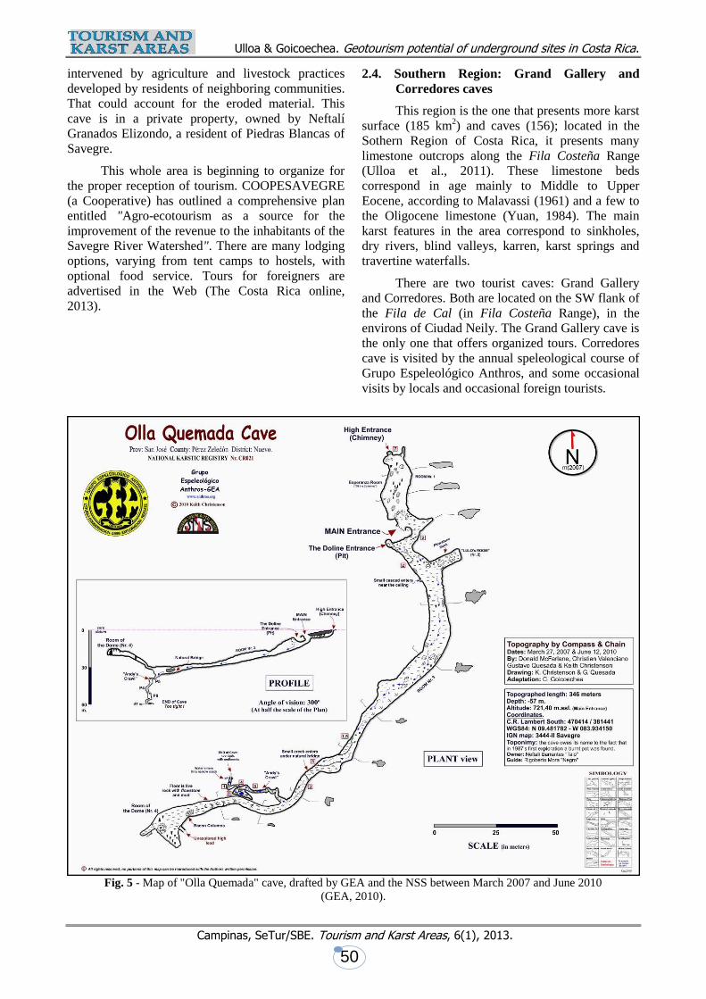
Olla Quemada cave is situated in the
limestone hills that rise south of the small town of
Piedras Blancas de Brujo, on the south bank of the
Savegre River, about 37 linear km WNW of the port
of Quepos, an important tourist destination. Piedras
Blancas can be accessed only by hiking or a horse
ride; there are three possible routes: Cerro Nara, el
Brujo and La Chaqueta; all require hiking through
the tropical forest. A local guide is needed to reach
the cave and the final route up to the cave is a rustic
trail, in which even horses have difficulty going up.
This cave has been known to scouts and locals since
around 1985, but was re-discovered by some
members of the Costa Rican Speleological
Association (AEC) in September 12, 1987. Carlos
Goicoechea drew the first 'sketch' of this cave. In
August 2009 the cave was visited by Keith
Christenson, of the NSS, who located it with a GPS
and provided some modifications to the initial sketch
map. During 2010, GEA performed another survey
and completed the exploration of the entire cave
(Figure 5). A total depth of 57 m was reached,
besides completing the map of the 346 m of its
length.
Olla Quemada cave does not exhibit a
profusion of formations, except in the Hall of
Columns and there are some passages with an
important amount of sediments. The main entrance
is inclined and opens 1.40 m above the ground, at
the base of a muddy wall. It has 4 meter wide and
1.40 m high, surrounded by jungle. Entrance Nr 2 is
a sinkhole about 2 m in diameter that drops 12
meters to the cave's floor. After this entrance opens
Room Nr 1 on the left side (Esperanza Room, aka
the Column's Room), which ends in 2 chimneys that
lead vertically to the outside. Following a fairly
straight line, the visitor continues along the main
passage, up to 10 m high, passing on the left side by
Room Nr 2 (Don Lulo's Room) and then on forward
to Room Nr 3. Here starts a narrow dirt-floor
gallery, with a low ceiling (2 m high), which leads to
Room Nr 4 (The Dome Room), up to 10 m high. At
point 'C' (on the map), on the right side, starts a tight
fracture, at the end of which opens 'Andy's
Crawlway', only 0.40 m high. This catwalk becomes
vertical, shaping into 3 short consecutive tight pits -
(5, 4 and 8 m)- that sort of "corkscrew" down to a
point where one can not go on any further. Tourist
tours correspond to the main passage. There is also
much guano throughout the cave and bats, spiders,
crickets and similar insects. The cave is located in an
area where the primary forest has been rather
Ulloa & Goicoechea. Geotourism potential of underground sites in Costa Rica.
Campinas, SeTur/SBE. Tourism and Karst Areas, 6(1), 2013.
50
intervened by agriculture and livestock practices
developed by residents of neighboring communities.
That could account for the eroded material. This
cave is in a private property, owned by Neftalí
Granados Elizondo, a resident of Piedras Blancas of
Savegre.
This whole area is beginning to organize for
the proper reception of tourism. COOPESAVEGRE
(a Cooperative) has outlined a comprehensive plan
entitled "Agro-ecotourism as a source for the
improvement of the revenue to the inhabitants of the
Savegre River Watershed". There are many lodging
options, varying from tent camps to hostels, with
optional food service. Tours for foreigners are
advertised in the Web (The Costa Rica online,
2013).
2.4. Southern Region: Grand Gallery and
Corredores caves
This region is the one that presents more karst
surface (185 km2) and caves (156); located in the
Sothern Region of Costa Rica, it presents many
limestone outcrops along the Fila Costeña Range
(Ulloa et al., 2011). These limestone beds
correspond in age mainly to Middle to Upper
Eocene, according to Malavassi (1961) and a few to
the Oligocene limestone (Yuan, 1984). The main
karst features in the area correspond to sinkholes,
dry rivers, blind valleys, karren, karst springs and
travertine waterfalls.
There are two tourist caves: Grand Gallery
and Corredores. Both are located on the SW flank of
the Fila de Cal (in Fila Costeña Range), in the
environs of Ciudad Neily. The Grand Gallery cave is
the only one that offers organized tours. Corredores
cave is visited by the annual speleological course of
Grupo Espeleológico Anthros, and some occasional
visits by locals and occasional foreign tourists.
Fig. 5 - Map of "Olla Quemada" cave, drafted by GEA and the NSS between March 2007 and June 2010
(GEA, 2010).

Ulloa & Goicoechea. Geotourism potential of underground sites in Costa Rica.
Campinas, SeTur/SBE. Tourism and Karst Areas, 6(1), 2013.
51
Grand Gallery cave is located in the base of a
cliff, inside a large sinkhole and present 3 access
points. The cave was locally known, but was re-
discovered by Gordon McCracken and Carlos
Goicoechea in 1989. The farm where it is located
belonged to a Panamanian nicknamed "Chiricano"
(Jorge Vidal), but he sold it some years ago to Alvis
Mora Salas. This man built a large house near the
cavity and is starting to offer it as a "show-cave".
For now, there is already a good path open to the
entrance. This cave has 148 m length and 26,4 m
depth, according to the NSS map (Figure 6). There is
no running water inside the cave presently, but it is
speculated that in the past the water of the Quebrada
Seca (Dry Creek) flowed into this cave (Peacock;
Hempel, 1993).
The tours offered in Grand Gallery cave
include visiting the nearby Quebrada Seca sink and
optionally, the entrance to a cave that is located at
the sink-site, named Macameca. During the visit, a
good description of both the flora and fauna that
characterizes the region is provided by a
professional in tourism. It can also be reached by
means of a 26 m rappel from the top of the cliff atop
the cave, an activity provided with an extra
expenditure.
The business that manages the cave operates a
web-site where there are information on topics such
as wildlife and other appeals included in the tours, as
well as accommodation and food facilities in the
neighboring Ciudad Neily (Cavernas Guayabí,
2013). These tours have duration of 5 to 6 hours, the
cost ranges from $ 20 (minimum 2 people) to $ 50
(single person). It is required to fill-in and sign a
liability release form by the tour operator.
2.5. Abismo Oscuro cave (Dark Abyss)
This facility is situated at Quebrada Honda of
Patarrá, about 10 km South of San José (30 minutes
drive). It is within the Fossil Land Complex, on the
farm of Otto von Schroeter. This region only has 6
km2 of limestone outcrop and there are reports of
only six caves (Ulloa et al., 2011). This is a
bioclastic limestone, with abundant fossils
(principally Pecten sp.) and of Miocene age. In
general, there are some incipient karst features, like
small caves (Ulloa et al., 2011). Fossils abound
throughout the park, but especially on a large wall
that is showcased to the tourist, where they can dig
their own “souvenirs”. This segment presents only
one tourist cave, named Abismo Oscuro (Dark
Abyss), also known as "Captain Tula's Cave" and /
or Patarrá Pit.
Fig. 6 - Profile and plant map of Grand Gallery Cave. Modified from Peacock; Hempel (1993).

Ulloa & Goicoechea. Geotourism potential of underground sites in Costa Rica.
Campinas, SeTur/SBE. Tourism and Karst Areas, 6(1), 2013.
52
Dark Abyss cave is small (69.5 m length and
24.1 m depth). This pit was probably discovered by
a laborer of the von Schroeter farm, on an
unspecified date. As early as 1968, there were
speculations about 'chasms' and caves in this area. It
appears that journalists from TV Channel 6
(REPRETEL, "The Explorer"), back in 2000,
wanted to film and photograph the cave. This led to
a power plant being introduced inside the cavity.
The obvious results were air contamination and all
of them had to be evacuated in an emergency. The
Asociación Espeleológica Costarricense (AEC)
apparently visited the site in 2002, but without
issuing a report or sketch. GEA explored and
surveyed it on July 2010 (Figure 7), and since then it
is used as a practice site added to the caving courses
that are taught. Proprietor is Mr. Otto von Schroeter
(and family).
"Fossil Land" keeps the place clean and has
suspended the extraction of limestone in the area
where the cave is located. There is entirely no water
inside the cave, except that which enters during
rainfalls. Air circulation inside the cave isn't ideal,
gases seem to pile-up and stagnate, but not to the
point of being critical. The venture's owners have
installed three metal ladders, so no rope work is
necessary, unless one wants to avoid the use of them
and have fun on-rope. The site is a tourist operation
since October 2001 and has a web page site
(Fossilland, 2013). Among the attractions, it offers
abseiling (rappel), caving, canopy for children,
mountain bike, ATV, paintball, geological tours,
climbing, camping and hiking. The Park is open
Monday through Saturday, with previous
reservation. On Sundays it operates from 9 a.m. to 4
p.m. The fares range from $ 11 to $ 67, depending
on the amount of people and the number of
attractions booked. Fast foods services have also
been implemented.
2.6. Other tourism potential karst areas
There are some caves that are close to
presently operating tourist places that have
occasional visitation, which could well be used
entrepreneurially for such purposes, according to its
localization. La Capilla cave opens in Portete, close
to the Port of Limón area; presently there's an on-
going development of it as a modern port, with
heightened tourism opportunities. Although
historically it is mentioned since 'the 70's', it was not
until 1994 that the Centre d'Etude du Karst
inspected it (Guilli et al., 1994), but according to
their description it was collapsed after the Limón
earthquake, and has low tourism potential.
Fig. 7 - Plant and profile of the 'Dark Abyss', located in the "Fossil Land Tourist Complex",
in Quebrada Honda of Desamparados, San José (GEA, 2010).

Ulloa & Goicoechea. Geotourism potential of underground sites in Costa Rica.
Campinas, SeTur/SBE. Tourism and Karst Areas, 6(1), 2013.
53
Malpaís is a rocky and sandy beach, located
on lower western flank of the Nicoya Peninsula and
frequented mainly by surfers. This is a small area
with karstic signs (5 km2) and according to Calvo
(1987) the limestone is of Middle-Upper Eocene
age. Anthros Speleological Group (GEA) has
located, explored and surveyed some small sized
caves: Peñón cave (a 16.6 meter long 'V'-shaped
cave, with a sand & pebbles floor), Pochote-115
cave (34.2 m long and 5 m depth), La Grande cave
(The largest, 112 m long and 18 m deep, located
inland); a beach rock-shelter is also present. This
group of caves or grottos, located within a 200 by
250 meters area which lies between the Pacific
Ocean and some small limestone hills that rise next
to it, are a local attraction and are sometimes shown
to tourists. There is no understructure at all, but they
are located on a Protected Land Area (Refugio de
Vida Silvestre Cueva de Los Murciélagos), which is
part of the Cabo Blanco Absolute Natural Reserve.
The largest ("La Grande",) is perhaps the only one
worth while a visit of this type, since it consists of a
larger 20 by 15 meter central room, out of which
originate 3 galleries, the largest about 22 m long. It
is fairly decorated, but has suffered a bit of
vandalism.
3. OTHER NON-KARSTIC UNDERGROUND
SITES WITH TOURISTIC POTENTIAL
3.1. Mine tunnels in Costa Rica
As discussed earlier, mining extraction of
metals led to many mine tunnels being dug in
different mine districts along Costa Rica. Among
those tunnels, some are abandoned and others are
still exploited, principally for artisanal mining
(small-scale miners and "coligalleros"). As a result
of this activity, in the highest production areas were
left a large amount of tunnels and/or perforations,
which reached important dimensions in both the
horizontal and the vertical aspects. A few have been
conditioned as tourism resources, in which the
attractive of the perforations and other charms of the
sector are combined, such as rivers, forests,
swimming holes & pools, horse riding, ATV rentals,
museums, etc. Incipient examples of this are
happening in several places.
Where the Union Mine operated, in Desmonte
of San Mateo (Alajuela), a small fee is charged for
visiting 150 meters of partially illuminated and
rustic mining tunnels, combined with the sale of
meals and the opportunity to take a dip in the
mountain stream that runs just alongside the tunnel.
Parking and souvenir stores are available.
In the city of Abangares (Guanacaste) is the
"Eco-Museum of the Abangares Mines", which
displays large amounts of the machinery used in the
extraction and transport of gold material. Right there
was the largest operation center of the Abangares
Gold Fields Company.
3.2. Topolandia Tunnels, San Pedro of Pérez
Zeledón
The information available so far is limited. It's
located on a 25 minutes drive from downtown San
Isidro of Pérez Zeledón (Province of San José), on
the Inter American Highway (CA-2). Upon reaching
this town, it's 1 km to the northeast from the
intersection of the secondary road that leads into San
Pedro, adjacent to the Bailey bridge over the San
Pedro River. "Topolandia" consists of artificial
tunnels in weathered alluvial fans, some with
chambers up to 15 m deep. In several artificially
made and interconnected tunnels (Figure 8), the
owner of the property has established a museum,
exhibition hall, conference room and other facilities.
Open all year round, 8 a.m. to 5 p.m. Fees: $ 4 adults
and $ 2 children. It advertises 'controlled
temperature' (between 18 ° and 24 ° C), mineralized
drinking water from 2 wells (15 m deep pond),
sculptures, stone beds, bathrooms and outside
recreational areas. The tour lasts for 1 to 2 hours
(Jara, 2013)
Figure 8. Aspect of part of the facilities at "Topolandia",
seen from across the access road (Jara, 2013).
4. DISCUSSION
In Costa Rica, the use of caves for tourism
purposes is a fairly recent activity. It began in 1974,
with the declaration of the Barra Honda hills
(Nicoya, Guanacaste) as a National Park, in order to
protect the 50 caves discovered to that date. Even
before this, some caves in different parts of the
country were visited locally during holidays and

Ulloa & Goicoechea. Geotourism potential of underground sites in Costa Rica.
Campinas, SeTur/SBE. Tourism and Karst Areas, 6(1), 2013.
54
special occasions. Around 1976 starts the offering of
tours at the Venado Cave, in San Carlos of Alajuela,
and around 2002, 'Fossil Land Recreational Park'
opens, in Quebrada Honda of Desamparados (San
José). Late in 2010, Grand Gallery Cave, in the
southern zone of the country, joins the tourism offer.
More recently, informal tours to Olla Quemada Cave
(Savegre River, San José) began to be carried out,
but without any special organization. Other caves,
like Damas Cave, in Parrita and Corredores Cave, in
the county of the same name (Both in Puntarenas
province), are occasionally visited by tourists, both
foreign and national, but there is no operational
structure. Therefore it can be said that, although
tourism is nowadays the largest source of national
income, the share corresponding to 'cave related
tourism' is quite low, representing an almost
negligible part of the total.
A comparison of Costa Rica's tourist caves is
presented in table 2.
Even though, in the aspect of 'using caves as a
means of promoting tourism', the undertaking should
come from the private sector, Grupo Espeleológico
Anthros (GEA) -a non profit organization- is
visualizing the option of proposing to the proper
government officials that several specific karst areas
be declared as "protected land". This project,
nevertheless, is in the preliminary stages. There is a
special interest in protecting the caves around
Ciudad Neily, because there are some important
karst systems, such as Quebrada Seca, Carma and La
Bruja/Corredores, which have important springs.
Presently, Carma cave is a source of drinking
water and is under partial administration by the local
municipality and the AYA (National Water
Administration Institute). This area covers an
extensive basin, where several large caves open and
has a hydrological connection with the next
'proposed' area, which drains into the Corredores
River: the fault-line segment where the Quebrada
Seca area caves are located, such as Grand Gallery
and Macameca. This project should also comprise
the "Bruja / Rectángulo / Tururún / Corredores
System" (Corredores county, southern part of the
province of Puntarenas).
ACKNOWLEDGEMENTS
This work couldn't have been properly
accomplished without the dedicated assistance of
fellow cavers Ferdinando Didonna, Gustavo
Quesada and the totality of the associates of Grupo
Espeleológico Anthros (GEA), dedicated since 1996
to the study of the caves & karst of Costa Rica and
Central America. A special acknowledgment to
Gustavo Quesada for compiling the information of
table 1.
Table 2. Comparison of characteristics of the studied caves.
Data Gabinarraca Gran Galería Abismo
Oscuro
Olla
Quemada
Terciopelo La Cuevita
(Grotto)
Visitors per
guide
1 guide for up
to 15 visitors.
1 guide for up
to 10 visitors.
1-3 guides per
group.
1 guide for up
to 10 visitors.
1 guide for up
to 10 visitors.
1 guide for up
to 10 visitors.
Artificial
light
No No No No Yes Yes
Safety gear Helmet,
helmet-fixed
light and
rubber boots.
Helmet and
light.
Helmet and a
handheld
flashlight.
No gear
at all is
provided.
Flashlight
used to be
loaned.
Helmet,
harness, belay
rope & first
aid kit
(Carried by
the Guide).
Helmet &
first aid kit
(Carried by
the Guide).
Approx.
number of
visitors
Presently: 500
by month. In
1996-97: 500
per week
(Aprox.).
N.A. 4600 persons
p/ year (2012
data).
100 persons
per year.
3600 visitors
per year.
Around 120
visitors per
year.
Tour
duration
1 to 2 hours 45 minutes to
1 hour
25 minutes 2 hours 1 hour and 30
minutes
45 minutes
Source Owners and
experienced
local guide.
Local guide
with
experience.
Fossil Land
Adventure
Park.
Local guide
with
experience.
National Park
Administrator
.
National Park
Administrator
.

Ulloa & Goicoechea. Geotourism potential of underground sites in Costa Rica.
Campinas, SeTur/SBE. Tourism and Karst Areas, 6(1), 2013.
55
BIBLIOGRAPHICAL REFERENCES
BUNDSCHUH, J.; BIRKLE, P.; FINCH, R.C.; DAY, M.J.; ROMERO, J.; PANIAGUA, S.; ALVARADO,
G.E.; BHATTACHARAYA, P.; TIPPMANN, K.; CHAVES, D. Geology-related tourism for
sustainable development. In: J. BUNDSCHUH; G.E. ALVARADO. Central America: Geology,
Resources and Hazards: New York, Taylor and Francis, Vol. 2, p.1015-1098, 2007.
CALVO, C. Las calizas neríticas de la vertiente Pacífica del norte de Costa Rica y sur de Nicaragua: Épocas
y sistemas asociados con la apertura y evolución del margen convergente de la América Central
meridional. 1987. 165 p. Tesis (Licensiatura en geología), Universidad de Costa Rica.
CALVO, C.; BOLZ, A. La secuencia de Venado, un estuario Lagunar del Mioceno Medio, San Carlos, Costa
Rica. Rev. Geológica Amer. Central, 6: p. 1-24, 1987.
CAMPOS, L.; ASTORGA, A. Guía Geoturística del Nor-oeste de Costa Rica. Univ. de Costa Rica (Versión
digital), 2010.
CASTILLO, R. Recursos minerales de Costa Rica, génesis, distribución y potencial. Universidad de Costa
Rica, 1997. 220 p.
CAVERNAS GUAYABÍ. Conociendo las cavernas. CAVERNAS GUAYABÍ, 2013. Available in:
<cavernasdelsur.ning.com>. Accessed in 01 jun. 2013.
DENYER, P.; ALVARADO, G., Mapa Geológico de Costa Rica. Escala 1:450 000. Librería Francesa S. A.,
2007.
DURANGO, O. Estudio espectrográfico y geoquímico de los artefactos encontrados en las tumbas de los
indios de Costa Rica: Informes, Dpto. Geología, Minas y Petróleo, Nº 7, 44p, 1961.
ESCAPE VILLAS. Amazing Caves in Costa Rica Offer True Caving Experiences. ESCAPE VILLAS, 2013.
. Available in: <www.villascostarica.com/blog/2011/03/caving-in-costa-rica>. Accessed in 01 jun.
2013.
FOSSILLAND. Fossilland Costa Rica: nature geology and adventure. FOSSILLAND, 2013. Available in:
<www.fossillandcr.com>. Accessed in 03 jun. 2013.
GEA. – GRUPO ESPELEOLÓGICO ANTHROS. Plano de la cueva Terciopelo. San José, GEA, 2003. 1
plano.
GEA. – GRUPO ESPELEOLÓGICO ANTHROS. Plano de la caverna Gabinarraca. San José, GEA, 2007. 1
plano.
GEA. – GRUPO ESPELEOLÓGICO ANTHROS. Plano de la cueva de Damas. San José, GEA, 2006. 1
plano.
GEA. – GRUPO ESPELEOLÓGICO ANTHROS. Plano de la cueva Olla Quemada. San José, GEA, 2010. 1
plano.
GEA. – GRUPO ESPELEOLÓGICO ANTHROS. Plano de la cueva Abismo Oscuro. San José, GEA, 2010.
1 plano.
GILLI, E., DELANGE, P., & LARRE, P. Reconnaissance sur la Neotectonique dans les Karsts du Costa
Rica. Centre d’Etude du Karst (CEK). Nice, France, 1994. 52 p.
GOICOECHEA, C.; QUESADA, G.; ULLOA, A. Evolution of speleology in Costa Rica. 15th International
Congress of Speleology. Kerville, Texas, USA. 3: 1985., 2009.
HAPKA R., BRASEY J., GOICOECHEA C. & JEANIN P. I.: Explorations dans le Karst Tropicaux du
Costa Rica. Cavernes 1, SSS, Suiza, 1992.

Ulloa & Goicoechea. Geotourism potential of underground sites in Costa Rica.
Campinas, SeTur/SBE. Tourism and Karst Areas, 6(1), 2013.
56
INBIO. Conservación in situ: áreas silvestres protegidas. INBIO, 2013. Available in:
<www.inbio.ac.cr/es/biod/estrategia/Paginas/esfuerzos_conservar01.html>. Accessed in 01 jun. 2013.
JARA, J.D. Adéntrese en los laberintos de Topolándia. PEREZ ZELEDÓN, 2013. Available in:
<www.perezzeledon.net/1428/adentrese-en-los-laberintos-de-topolandia>. Accessed in 01 jun. 2013.
LA NACIÓN. Turismo de Costa Rica alcanza indicadores que tenía antes de la crisis mundial del 2009.
Available in: <www.nacion.com/2013-04-09/Economia/turismo-de-costa-rica-alcanza-indicadores-
que-tenia-antes-de-la-crisis-mundial-del-2009.aspx>. Accessed in 03 jun. 2013.
MALAVASSI, E. Some Costa Rican larger foraminiferal localities. –J. Paleont. 35: 498 – 501, 1961.
MALAVASSI, V.E. & MADRIGAL, R. Reconocimiento geológico de la Zona Norte de Costa Rica. Inf.
Tec. y Notas Geol. (38): San José, Costa Rica. 1970. 1-18 p.
MORA CASTRO, S. Barra Honda. Editorial UNED, 1981. 29 p.
NSS (NATIONAL SPELEOLOGICAL SOCIETY): Caves & Karst of the Barra Honda National. Park,
Costa Rica. NSS, 1989.
OBANDO, L. G., Estratigrafía de la Formación Venado y rocas sobreyacientes (Mioceno-Reciente) Prov. de
Alajuela, Costa Rica. Rev. Geol. Amer. Central 5. 1986. 73-104 p.
PEACOCK, N.; HEMPEL, J. Studies in the rio Corredores basin. –NSS journal of caves and karst, 55: 5-31.
1993.
QUESADA, G., Baldizón, I., PORRAS, J.J., GRANT, I., LEÓN, S., VILLALOBOS, J. Estudio de
Capacidad de Carga para la Caverna Terciopelo en el Parque Nacional Barra Honda. San José: Grupo
Espeleológico Anthros, 2006. 43 p.
THE COSTA RICA ONLINE. Trek Cuenca del Savegre. THE COSTA RICA ONLINE, 2013. Available in:
<thecostaricaonline.com/en/nuestras-rutas/turismo-rural/trek-cuenca-del-savegre>. Accessed in 01 jun.
2013.
ULLOA, F., Historia minera de Costa Rica: Informe interno, Dirección de geología Minas y Petróleo, 1979,
50 p.
ULLOA, A. Caves of Costa Rica (Central America) and their geologic origin. 15th International Congress
of Speleology. Kerrville, Texas, USA. 3:1930-1935, 2009.
ULLOA, A., AGUILAR, T., GOICOECHEA C. & RAMÍREZ R. Descripción, clasificación y aspectos
geológicos de las zonas kársticas de Costa Rica. Revista Geológica de América Central, 45: p. 53-74,
2011.
WELLS, S. Geological Reconaissance of the Barra Honda Karst. Department of geology, University of
Cincinnati, USA, 1974, 29 p.
Editorial flow/Fluxo editorial: Received/Recebido em: 19.may.2013 Accepted/Aprovado em: 27.sep.2013
TOURISM AND KARST AREAS
(formely/formalmente: Pesquisas em Turismo e Paisagens Cársticas) Brazilian Speleological Society / Sociedade Brasileira de Espeleologia (SBE)
www.cavernas.org.br/turismo.asp