geothermal exploration l 181 for the period
TRANSCRIPT

Geothermal Resources Ltd
ABN 45 115 281 144
ANNUAL REPORT
GEOTHERMAL EXPLORATION LICENCE
181
FOR THE PERIOD
22 Nov. 2007 to 21 Nov. 2008
February 2009

TABLE of CONTENTS
1. Introduction
2. Work Completed
3. Reporting Against Requirements of the Petroleum Act 2000
4. Expenditure for Year 4
Tables
Figures
Appendices
LIST of TABLES
Table 1. Proposed Work Program ('original') for GEL 181
Table 2. Minimum Work requirements ('new') for GEL 181
LIST of FIGURES
Figure Title
1. 2-Dimensional isotherm map of temperatures
2. Location of Frome 12, GEL Boundaries and Pastoral Leases
3. Hole planned for Year 5 (Frome 13)
LIST of APPENDICES
APPENDIX 1 Assessment of Geothermal Resources performance in achievingEnvironmental Objectives (as defined in the Cooper Basin DrillingSEO, 2003)

1. Introduction
GEL 181 was granted to Havilah Resources NL on 22nd November 2004 andsubsequently transferred to Geothermal Resources Limited on 12th August 2005.
This is Geothermal Resources fourth year of tenure and the minimum workcommitment was to drill one deep (1800m) pilot hole (Table 1).This deep hole was spudded on 18th September and reached 1629.2m on 21st
November; (a total vertical depth of 1761.2m was reached on 30th November 2009).
Adjacent to GEL 181 Geothermal Resources also holds GELs 208, 209 and 210. Anoverall or 'grouped' exploration approach to the entire GEL block has been acceptedby PIRSA. From 22nd November 2008 a variation in the minimum work requirementsfor these GELs has been approved by Dr. Barry Goldstein, Director Petroleum,Minerals and Energy Resources, PIRSA. The original and changed work requirementsare presented in Tables 1 and 2 respectively of this document. Further, this groupingof Geothermal Resources Frome GELs was also restated and formalised. Specifically,Geothermal Resources Frome GELs 181, 208, 209 and 210 will be grouped as oneand have a common anniversary date (21st November). The common anniversarydates were achieved by the suspension of GELs 208, 209 and 210 from 11th August to21st November 2008.
2. Work Completed
Frome 5/5A:
Frome 5 (Latitude: 31o 38' 24.7"S Longitude: 139 o 48' 05.7"E [GDA 94])
was spudded on 14/02/2008 and abandoned at 130m (19/02/2008) owing to hungcasing. It was mud drilled by Talager Pty. Ltd. using an Almet Masters EX 300 RCrig.
Frome 5A (Latitude: 31o 38' 25.6"S Longitude: 139 o 48' 05.6"E [GDA 94])was spudded on 24/02/2008 and also abandoned (1/03/2008); specifically at 146metres owing to loose sand jamming the rods. The hole was mud drilled to 114metres and then cased with 100 mm PVC. Percussion drilling followed to 146 metres.It was also drilled by Talager Pty. Ltd. using an Almet Masters EX 300 RC rig. At113 metres green dolomitic siltstones were encountered – these continued to thebottom of hole. It is suggested that these siltstones are likely to be from theAmberoona Formation.
1
Frome 12:
Prior to drilling the ~1800 metre deep hole extensive temperature modelling and threedimensional stratigraphic interpretation were used to site the hole collar. All of theFrome holes were temperature logged along with other old mineral/stratigraphicholes; specifically: Frome 1A, Frome 2, Frome 3A, Frome 8, Frome 9, Frome 10,Frome 11, Telechie TM9W-1, Ben 0157, Cartspring and Emu Dam. This data wasmodeled using Vulcan software to produce a second order two dimensional isothermmap of temperatures in the Frome GELs. See Figure 1, the red 'bullseye' marks thepredicted hottest spot.
All available drill core was inspected and relogged in terms of current stratigraphicnomenclature. This data was again interpreted using Vulcan software to produce athree dimensional model that enabled visualization of the expected geology atpossible sites for the 1800 metre deep hole.
Data from the 'Curnamona Deep Seismic Survey, (2003-20040)' was reinterpreted.The Adelaidean sediments were interpreted to have many horizontal and sub-horizontal reflections resulting from the bedding in the rocks. Conversely, the buriedgranite was interpreted to give no/few reflections because of its presumedhomogeneity.
The above temperature modelling, the new stratigraphic model and thereinterpretation of the seismic data were combined with the previously known anddocumented gravity and magnetic data to site Frome 12 at what was believed to be anideal position for a deep geothermal hole.
The location of Frome 12 is shown in Figure 2. In accordance with the proposed workprogram, Geothermal Resources drilled one deep pilot hole. This hole has thecoordinates (GDA 94):Latitude: 31º 35' 51.6"SLongitude: 139º 47' 22.8"E.
Frome 12 was drilled by Silver City Drilling, using a Hydco 1000H rig. The hole wasspudded on 18th September and reached 1629.2m on 21st November; (a total verticaldepth of 1761.2m was reached on 30th November 2009).
The hole was mud drilled to 3.6m and 150 mm PVC casing run and pressurecemented. PQ diamond coring was used to the commencement of hard rock at 155.8metres depth. HQ diamond coring continued within the PQ rods (ie. HWT casing) to1200 metres depth. NQ diamond coring continued (within the HQ rods) to 1629.2metres on the 21st November (a total vertical depth of 1761.2m was reached on 30th
November 2009).
2

Drilling conditions were mostly very good with all of the HQ drilling achieved usingonly one bit (ie. 1044.2m). A slow drilling rate was successfully employed in an effortto keep the hole vertical; the hole started at -89º and finished at -89.2º.
In view of the remote possibility of a gas encounter the following measures weretaken with safety as the foremost consideration:
The HWT casing was pressure cemented in, The return mud was continuosly checked for a gas encouter using a Riken four
gas detector, All drilling ocurred through a diverter assembly, A stabbing valve was kept 'on the rig floor' so that the well could be closed in,
in the event of a gas encounter, A 50 metre flare line was kept assembled ready to be connected to the diverter
in the event of a low pressure gas encounter, A flare pit was located 50 metres down wind from the hole collar (at the far
end of the flare line), A high pressure mud pump was positioned next to a sump reserved for 'kill
mud', 'Kill mud' chemicals were kept next to the high pressure mud pump, All drilling occurred with mud weighted to approximately 1.08 SG (achieved
by the addition of sodium chloride), and The drilling mud was regularly monitored for mud weight, viscosity and pH,
and the required adjustments made.
It is pleasing to report that no gas was encountered.
TEMPERATURE LOGGING
Downhole temperature logging of Frome 12 was carried out in four phases. The firsttwo of these phases occurred in the report period:
As drilling progressed the hole was surveyed using a digital Camteq surveyinstrument. These surveys, often around every 60 metres of progress, not onlyprovided dip, azimuth and other data; but, also temperature measurements.
At 1000m depth drilling was suspended to allow temperature equilibrationbetween the hot rocks and the residing drilling mud. After three days ofequilibration the 1000m sequence was logged for temperature and Gammaradiation at 5cm intervals by the Department of Water, Lands, andBiodiversity Conservation.
{For completeness, the following linked phases are noted even though theymarginally occurred out of the reporting period. At total vertical depth, and after 3 days of equilibration time, the top 1050
metres was relogged for both temperature and Gamma radiation byGeoscience Australia.
At total vertical depth, and after 4 days of equilibration time the deeper portionof the hole, specifically from 1200m to 1760m was temperature logged usingGeothermal Resources 'Sterilcyl' and 'i-button' temperature probes in anEastman Kodak barrel positioned using the wireline of SCD's Hydco 1000Hrig.}
3

3. Reporting Against Requirements of the Petroleum Act 2000
(a) Summary of regulated activities conducted under the licence during theYear
The drilling of Frome 12 commenced and advanced to a vertical depth of 1629.2m bythe end of the reporting period. {Drilling continued into the next reporting year.}The hole was logged continuously from surface to 1000m for both temperature andgamma radiation.
(b) Report for the Year on compliance with the Act, these regulations, the licenceand any relevant statement of environmental objectives
Geothermal Resources carried out its field activities in accordance with the CooperBasin Drilling SEO, dated November 2003 (see Appendix 1). All prevention andremediation measures, as listed in Appendix 1, were diligently followed. GeothermalResources is not aware of any SEO non-compliance issues. A PIRSA engineerinspected the site/operation and commended the company for: a clean well plannedsite, safety arrangements, signage and recent rehabilitation work.
All obligations were complied with, other than the late submissions for the annualreport, well completion reports and wire-line LAS files. The annual report was notsubmitted within 2 months after the end of the licence year as required by Regulation33. It was submitted within 3 months of the end of the licence year. This was largelydue to the new writer assuming that there was a 3 month 'window'. The wellcompletion reports for Frome 2, and Frome 3/3A were variably late, by up to 5months, as the staff member to write them took up their position late (the WCR forFrome 5/5A was submitted early).
(c) Actions to rectify non-compliance with obligations imposed by the Act, theseregulations or the licence, and to minimise the likelihood of the recurrence of anysuch non-compliance
A new staff member has been appointed.
The new staff member now knows the Annual Report regulations and intends to usethe Annual Report Guidelines proforma in future.Additionally, the new staff member knows the submission requirements for WellCompletion Reports and has the time to fulfil them.The new staff member now knows that Wire-line log LAS files must be submittedwithin 2 months of survey – separate from any WCR or Annual Report.
(d) A summary of any management system audits undertaken during therelevant licence Year, including information on any failure or deficiencyidentified by the audit and any corrective action that has, or will be, taken
Management closely monitored all activities and did not detect any reportabledeficiencies or incidents.
4

(e) List all reports and data relevant to the operation of the Act during therelevant licence Year
Report Due date Date submitted Statement ofcompliance
2007 Annual Report 21 Jan. 2008 Feb. 2008 Late; ie. non-compliantWCR for Frome 2 28 Dec. 2007 May 2008 Late; ie. non-compliantWCR for Frome 3/3A 14 Jan. 2008 May 2008 Late; ie. non-compliantWCR for Frome 5/5A 19 Aug. 2008 June 2008 Compliant (early)Notification of Activity not applicable 5 Jun. 2008 Compliant (early)Frome 5: DailyDrilling Reports
15/02/2008 to20/02/2008
15/02/2008 to20/02/2008
Compliant
Frome 5A: DailyDrilling Reports
25/02/2008 to2/03/2008
25/02/2008 to2/03/2008
Compliant
Frome 12: DailyDrilling Reports
19/09/2008 to21/11/2008
19/09/2008 to21/11/2008
Compliant
Frome 2 Wire-line logLAS files(Temp. & Gamma)
{19 Nov 2007} Feb. 2008 Late; ie. non-compliant
Frome 3A Wire-linelog LAS files(Temp. & Gamma)
26 Nov. 2007 Feb. 2008 Late; ie. non-compliant
Note: { } are used to indicate from previous reporting period
(f) Report of incidents reportable to the Minister under the Act and regulations
No incidents occurred and therefore none were reported.
(g) Report on any reasonably foreseeable threats that reasonably present, or maypresent, a hazard to facilities or activities under the licence, and a report on anycorrective action that has, or will be, taken.
No threats identified.
(h) Operations proposed for the ensuing Year
During Year 5 it is proposed to: Complete the drilling of Frome 12 to approximately 1800m. Temperature log Frome 12 to total depth. Drill at least one other approximately 1800m deep diamond hole within the
group of Frome GELs comprising: 181, 208, 209 and 210; this well will becalled Frome 13 and its location can be seen in Figure 3.
Temperature log the above hole. Measure the thermal conductivities of sediment samples from Frome 12. Relog Frome 12 for temperature (months after rig release). Model the temperature and thermal conductivity data three dimensionally.
5

4. Expenditure for Year 4
Commercial in Confidence
6

TABLE 1: Proposed Work Program ('original') for GEL 181
Year Work Commitment Work completedOne Gravity survey Database compilation, acquisition existing gravity
and seismic data.Two Data review Selection of drill sites.
Aboriginal heritage survey.Submission of Activity Notification.Submission for PACE grant – (received DPY 3-77).
Three Drill one shallow hole Completion of two drillholes to approx. 500m:Frome 2, and Frome 3/3A.Temperature logging of these holes.
Four
Drill one deep pilot hole
Frome 5/5A drilled to 146m (prior to the drilling ofFrome 12).
Lodgement of Activity Notification for Frome 12.Frome 12 drilling ahead at 1629.2m.{Completion of Frome 12, at 1761.2m, less thantwo weeks into next year.}Temperature and gamma radiation logging ofFrome 12 to 1000m ('continuous' measurements).
Five Drill one production welland one injection well
TABLE 2: Minimum Work Requirements ('new') for GEL 181
Year ofTerm ofLicence
Minimum Work Requirements
One Geological and geophysical studies.
Two Geological and geophysical studies.
Three Drill two shallow holes.
Four Drill one deep pilot hole to 1800m depth.
Five
Review of pilot hole results and decision on drilling production wells.
Year 5 work program to be conducted anywhere within the boundaries GELs181, 208, 209 and 210.
7

Figure 1. 2-Dimensional isotherm map of temperatures.The red 'bullseye' marks the predicted hottest spot and approximatelocation of Frome 12.
8

Figure 2. GEL boundaries, pastoral leases and location of Frome 12 (red label).[Previously drilled Frome holes have yellow-orange labels.]
9

Figure 3. Location of proposed (for Year 5) 1800m deep hole, Frome 13 (yellow star).
Frome 13
0 kilometres 10
10

APPENDIX 1
ASSESSMENT of GEOTHERMAL RESOURCES
PERFORMANCE IN ACHIEVING
ENVIRONMENTAL OBJECTIVES
(as defined in the COOPER BASIN DRILLING SEO, 2003)
for all Drilling and Well Operations
in GEL 181 (AR 2008)
11

ASSESSMENT of GEOTHERMAL RESOURCES PERFORMANCE IN ACHIEVINGENVIRONMENTAL OBJECTIVES (as defined in the COOPER BASIN DRILLING SEO, 2003)
2008 AR: GEL 181 (all Drilling and Well Operations)
EnvironmentalObjectives
Assessment Criteria Compliant/Non-Compliant
Comment
Objective 1:
Minimise the risk to publicand other third parties.
Objective 2:
Minimise disturbance andavoid contamination to soil.
Reasonable measuresimplemented to ensure noinjuries to the public or thirdparties.
Well Site and Access TrackConstruction 0, + 1 or + 2 GAS criteria are
attained for 'Minimise visualimpacts of abandoned well sitesand access tracks' objective aslisted in Appendix 4 for welllease and access trackconstruction. No unauthorised off-road
driving or creation of shortcuts. No construction activities are
carried out on salt lakes, steeptableland land systems orwetlands land systems (asdefined in EIR).
Fuel and Chemical Storage andHandling No spills/leaks outside of areas
designed to contain them. Level of hydrocarbon
continually decreasing for insitu remediation of spills. Soils remediated to a level as
determined by the SHI process.
Waste Disposal(domestic, sewage and sludges) All domestic wastes are disposed
of in accordance with WPAlicensing requirements. 0, + or + 2 GAS criteria for
'Waste material' objective isattained.
Compliant
Well Site andAccess TrackConstruction:
Compliant
GAS +1
Fuel and ChemicalStorage andHandling:
Compliant
Waste Disposal:
Compliant
GAS +2
GAS of +1, rather than +2,because the earthworkdisturbance is only beginning toblend with the surroundings.
12

EnvironmentalObjectives
Objective 3:
Avoid the introduction orspread of pest plants andanimals and implement controlmeasures as necessary.
Objective 4:
Minimise disturbance todrainage patterns and avoidcontamination of surface waterand shallow ground waterresources.
Objective 5:
Avoid disturbance to sites ofcultural and heritagesignificance.
Objective 6:
Minimise loss of aquiferpressure and avoid aquifercontamination.
Assessment Criteria
No weeds or feral animals areintroduced to operational areas.
Well Lease and Access TrackConstruction. Well leases and access tracks
are located and constructed tomaintain pre-existing waterflows (ie. channel contours aremaintained on floodplains andat creek crossings).
Drilling Mud Sumps and FlarePits No overflow of drill cuttings,
mud and other drilling fluidsfrom mud sumps. No waste material disposal to
sumps and flare pits.
Fuel/Chemical Storage andHandling No leaks spills outside of areas
designed to contain them.
Proposed well sites and accesstracks have been surveyed andany sites of Aboriginal andnon-Aboriginal heritageidentified. Any identified cultural and
heritage sites have beenavoided.
Drilling & Completion Activities There is no uncontrolled flow
to surface (Blow out). Sufficient barriers exist in
casing annulus to prevent crossflow between separate aquifersof hydrocarbon reservoirs. Relevant government approval
obtained for abandonment ofany radioactive tool left down-hole.
Compliant/Non-Compliant
Compliant
Compliant
Compliant
Compliant
Comment
13

Environmental Objectives
Objective 6 cont. :
Minimise loss of aquiferpressure and avoid aquifercontamination.
Objective 7:
Minimise disturbance to nativevegetation and native fauna.
Objective 8:
Minimise air pollution andgreenhouse gas emissions.
Objective 9:
Maintain and enhancepartnerships with the CooperBasin community.
Objective 10:
Avoid or minimise disturbanceto stakeholders and/orassociated infrastructure.
Assessment Criteria
Producing, Injection, Inactiveand Abandoned Wells No cross-flow behind casing
between aquifers, and betweenaquifers and hydrocarbonreservoirs unless approved byDWLBC.
Well Lease and Access TrackConstruction and Restoration Any sites with rare, vulnerable
and endangered flora and faunahave been identified andavoided. 0, + 1 or + 2 GAS criteria are
attained for 'Minimise impactson vegetation' objectives aslisted in Appendix 2, duringwell lease and access track siteselection and construction andfor 'Re-establish naturalvegetation on abandoned wellsites and access track' objectivein Appendix 4.
Waste Management Refer to assessment criteria for
Objective 11.
Fuel and Chemical Storage andManagement Refer to assessment criteria for
Objectives 2 and 4.
Compliance with EPArequirements.
No unresolved reasonablecomplaints from thecommunity.
No reasonable stakeholdercomplaints left unresolved.
Compliant/Non-Compliant
Compliant
Appendix 2 GAS:+2
Appendix 4 GAS:+1
Compliant
Compliant
Compliant
Comment
GAS of +1, rather than +2,because there are no perennials.
14
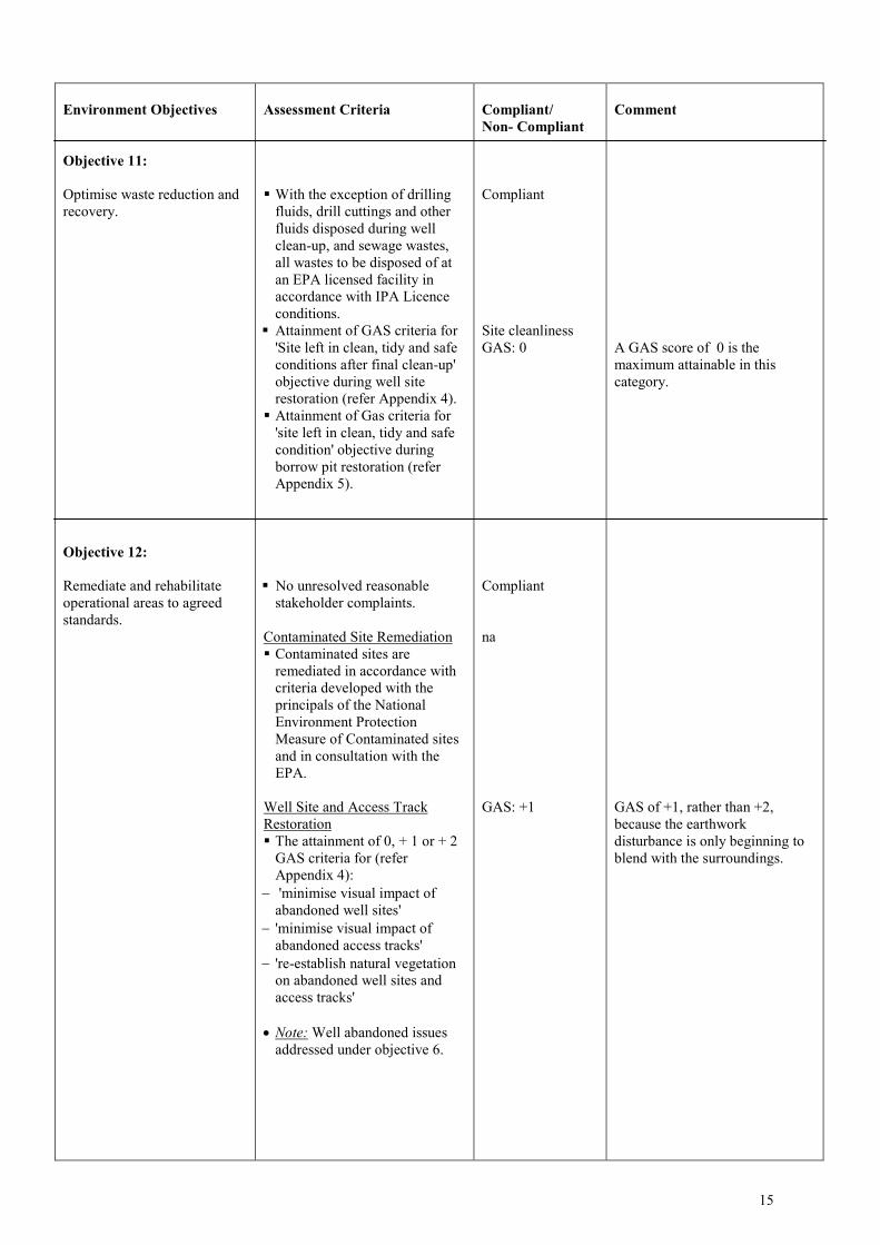
Environment Objectives
Objective 11:
Optimise waste reduction andrecovery.
Objective 12:
Remediate and rehabilitateoperational areas to agreedstandards.
Assessment Criteria
With the exception of drillingfluids, drill cuttings and otherfluids disposed during wellclean-up, and sewage wastes,all wastes to be disposed of atan EPA licensed facility inaccordance with IPA Licenceconditions.
Attainment of GAS criteria for'Site left in clean, tidy and safeconditions after final clean-up'objective during well siterestoration (refer Appendix 4). Attainment of Gas criteria for
'site left in clean, tidy and safecondition' objective duringborrow pit restoration (referAppendix 5).
No unresolved reasonablestakeholder complaints.
Contaminated Site Remediation Contaminated sites are
remediated in accordance withcriteria developed with theprincipals of the NationalEnvironment ProtectionMeasure of Contaminated sitesand in consultation with theEPA.
Well Site and Access TrackRestoration The attainment of 0, + 1 or + 2
GAS criteria for (referAppendix 4):
'minimise visual impact ofabandoned well sites'
'minimise visual impact ofabandoned access tracks'
're-establish natural vegetationon abandoned well sites andaccess tracks'
Note: Well abandoned issuesaddressed under objective 6.
Compliant/Non- Compliant
Compliant
Site cleanlinessGAS: 0
Compliant
na
GAS: +1
Comment
A GAS score of 0 is themaximum attainable in thiscategory.
GAS of +1, rather than +2,because the earthworkdisturbance is only beginning toblend with the surroundings.
15

16