exploration and development of the tawau geothermal ... · exploration and development of the tawau...
TRANSCRIPT
Proceedings World Geothermal Congress 2015
Melbourne, Australia, 19-25 April 2015
1
Exploration and Development of the Tawau Geothermal Project, Malaysia
Peter R. Barnett2, Susianto Mandagi
1, Tasrif Iskander
1, Zainal Abidin
1 Andrew Armaladdoss
2, Ramsey Raad
2
1 Green Asia Geotech, 2Tawau Green Energy
5th. Floor, Wismar Perkasa, Jalan Gaya, 88821 Kota Kinabalu, Sabah, Malaysia.
Keywords: Malaysia geothermal, Apas Kiri, resource assessment, drilling, exploration and development strategy
ABSTRACT
Surface geothermal activity has been reported at Tawau in Sabah in NW Borneo, since 1960 and various aspects have been studied
and reported irregularly through to the present time.
In 2010, Tawau Green Energy secured an exploration concession and carried out a comprehensive surface exploration program
comprised of detailed geology, MT geophysics and geochemistry surveys. The results of this program have confirmed the
existence of an active geothermal system centered on the SE slopes of Mt Maria, a young andesitic to dacitic volcano of Miocene to
Quaternary age resulting from subduction on the NW facing Sulu arc. The resource is structurally controlled by a series of NW
trending transcurrent faults and transpressional tectonics from the late Pliocene to the present day. The chemistry of surface springs
suggest a deep underlying neutral chloride fluid rising and outflowing the SE and the South with a deep temperature of about
200oC. An initial resource assessment has been made this yields approx. 85 MWe of potential development capacity at a probability
of 50% for a resource abandonment temperature of 170oC.
TGE is now preparing to drill two deep exploration wells into the central portions of the Mount Maria upflow. These will
commence in July 2014 and the results of the drilling program plus well testing are expected to be available for inclusion in this
paper by the time it has to be finalized
1. INTRODUCTION
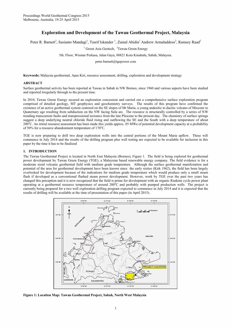
The Tawau Geothermal Project is located in North East Malaysia (Borneo), Figure 1. The field is being explored for geothermal
power development by Tawau Green Energy (TGE), a Malaysian based renewable energy company. The field evidence is for a
moderate sized volcanic geothermal field with medium grade temperature. Although the surface geothermal manifestation and
potential of the area for geothermal development have been known since the early sixties (Kirk 1962), the field has been largely
overlooked for development because of the indications for medium grade temperature which would produce only a small steam
flash if developed as a conventional flashed steam power development. However, work by TGE over the past two years has
changed this perception and it is now recognized that the field is prime for development with an organic Rankine cycle power plant
operating at a geothermal resource temperature of around 200oC and probably with pumped production wells The project is
currently being prepared for a two well exploration drilling program expected to commence in July 2014 and it is expected that the
results of drilling will be available at the time of presentation of this paper (in April 2015).
Figure 1: Location Map: Tawau Geothermal Project, Sabah, North West Malaysia
Barnett et al
2
2. PREVIOUS WORK
Previous work at the Tawau project has been well reported by Chong et al (2000) who noted a significant level of interest from the
early sixties through to the late eighties and that “momentum for research and development faded” thereafter. They recommended
that the way forward for the project was for a geophysical survey followed by exploratory drilling. Significantly they noted that
power generation via a binary cycle process would likely be feasible based on the results of chemical geothermometry from the
Apas Kiri hot springs.
The results of a first geophysics survey at Tawau were reported by Daud et al (2010) which describes the results of a 42 MT station
survey carried out over 15 lines spaced 1200 m apart on the southern slopes of Mt Maria and northern Mt Andrassy using MTU-5
units supplied by Phoenix Geophysics of Canada. TDEM measurements were also made to correct for static shifts in the MT
sounding curves. Interpretation of the MT data so gained showed a dome shaped geothermal reservoir structure centered in the
northern half of the survey area and open to the north.
TGE has continued exploration activities and extended this historical exploration work from 2011 onwards by resampling all
surface thermal activity, with analyses being undertaken by GNS of New Zealand, completing detailed geological and structural
mapping over the greater project area, and undertaking a further MT survey of 47 stations located to the north of the area of the
Daud et al (2010) survey on the upper flanks of Mt Maria.
3. GEOTHERMAL SETTING
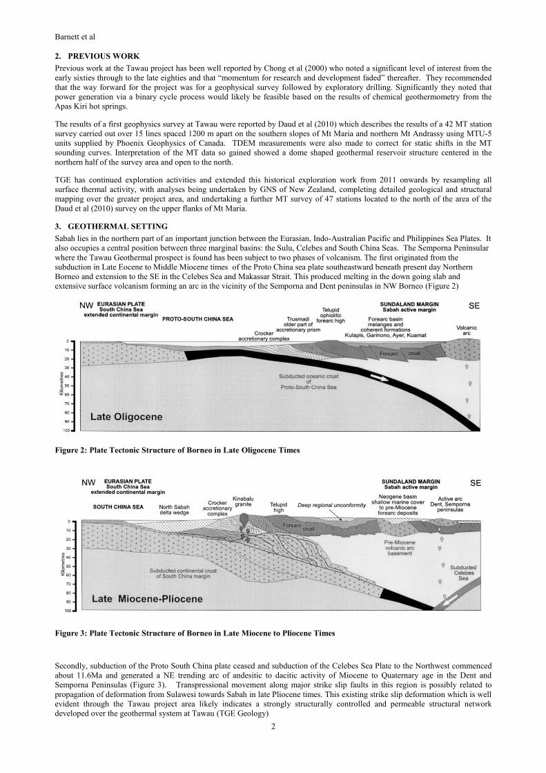
Sabah lies in the northern part of an important junction between the Eurasian, Indo-Australian Pacific and Philippines Sea Plates. It
also occupies a central position between three marginal basins: the Sulu, Celebes and South China Seas. The Semporna Peninsular
where the Tawau Geothermal prospect is found has been subject to two phases of volcanism. The first originated from the
subduction in Late Eocene to Middle Miocene times of the Proto China sea plate southeastward beneath present day Northern
Borneo and extension to the SE in the Celebes Sea and Makassar Strait. This produced melting in the down going slab and
extensive surface volcanism forming an arc in the vicinity of the Semporna and Dent peninsulas in NW Borneo (Figure 2)
Figure 2: Plate Tectonic Structure of Borneo in Late Oligocene Times
Figure 3: Plate Tectonic Structure of Borneo in Late Miocene to Pliocene Times
Secondly, subduction of the Proto South China plate ceased and subduction of the Celebes Sea Plate to the Northwest commenced
about 11.6Ma and generated a NE trending arc of andesitic to dacitic activity of Miocene to Quaternary age in the Dent and
Semporna Peninsulas (Figure 3). Transpressional movement along major strike slip faults in this region is possibly related to
propagation of deformation from Sulawesi towards Sabah in late Pliocene times. This existing strike slip deformation which is well
evident through the Tawau project area likely indicates a strongly structurally controlled and permeable structural network
developed over the geothermal system at Tawau (TGE Geology)
Barnett et al
3
4. LOCAL GEOLOGICAL SETTING
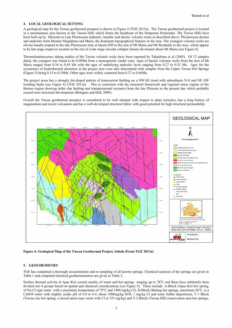
A geological map for the Tawau geothermal prospect is shown in Figure 4 (TGE 2013a). The Tawau geothermal project is located
in a mountainous area known as the Tawau Hills which forms the backbone of the Semporna Peninsular. The Tawau Hills have
been built up by Miocene to Late Pleistocene andesitic, basaltic and dacitic volcanic rocks as described above. Plesistocene dacites
and andesites form Mounts Magdalena and Maria, the dominant topographical features in the area. The youngest volcanic rocks are
olivine basalts erupted in the late Pleistocene time at Quoin Hill to the east of Mt Maria and Mt Bombalai to the west, which appear
to be late stage eruptives located on the rim of a late stage circular collapse feature developed about Mt Maria (see Figure 4).
Thermoluminescence dating studies of the Tawau volcanic rocks have been reported by Takashima et al (2005). Of 12 samples
dated, the youngest was found to be 0.09Ma from a monogenetic cinder cone. Ages of dacitic volcanic rocks from the foot of Mt
Maria ranged from 0.34 to 0.45 Ma with the ages of underlying andesitic lavas ranging from 0.27 to 0.52 Ma. Ages for the
occurrence of hydrothermal alteration in the project area were also determined with samples from the Upper Tawau Hot Springs
(Figure 5) being 0.15 to 0.19Ma. Other ages were widely scattered from 0.27 to 0.66Ma.
The project areas has a strongly developed pattern of transcurrent faulting on a NW-SE trend with subordinate N-S and NE–SW
trending faults (see Figure 4) (TGE 2013a) . This is consistent with the structural framework and regional stress regime of the
Borneo region showing strike slip faulting and transpressional tectonics from the late Pliocene to the present day which probably
caused most structural development (Belagaru and Hall, 2009).
Overall the Tawau geothermal prospect is considered to be well situated with respect to plate tectonics, has a long history of
magamatism and recent volcanism and has a well-developed structural fabric with good potential for high structural permeability.
Figure 4: Geological Map of the Tawau Geothermal Project, Sabah (From TGE 2013a)
5. GEOCHEMISTRY
TGE has completed a thorough reexamination and re-sampling of all known springs. Chemical analyses of the springs are given in
Table 1 and computed chemical geothermometers are given in Table 2.
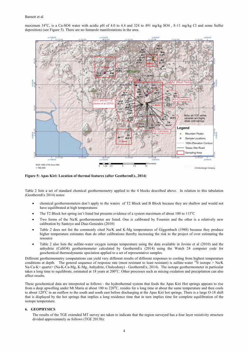
Surface thermal activity at Apas Kiri consist mainly of warm and hot springs ranging up to 78oC and these have arbitrarily been
divided into 4 groups based on spatial and chemical considerations (see Figure 5). These include: A-Block (Apas Kiri hot spring,
of Na-Cl type water with a maximum temperature of 78oC and 1400 mg/kg Cl), B-Block (Balung hot springs, maximum 56oC, is a
CaSO4 water with slightly acidic pH of 6.0 to 6.4, about 1000mg/kg SO4, 1 mg/kg Cl and some Sulfur deposition), T-1 Block
(Tawau city hot spring, a mixed anion type water with Cl at 353 mg/kg) and T-2-Block (Tawau Hill conservation area hot springs,
Barnett et al
4
maximum 34oC, is a Ca-SO4 water with acidic pH of 4.0 to 4.4 and 324 to 491 mg/kg SO4 , 8-11 mg/kg Cl and some Sulfur
deposition) (see Figure 5). There are no fumarole manifestations in the area.
Figure 5: Apas Kiri: Location of thermal features (after GeothermEx, 2014)
Table 2 lists a set of standard chemical geothermometry applied to the 4 blocks described above. In relation to this tabulation
(GeothermEx 2014) notes:
chemical geothermometers don’t apply to the waters of T2 Block and B Block because they are shallow and would not
have equilibrated at high temperatures
The T2 Block hot spring isn’t listed but presents evidence of a system maximum of about 100 to 115oC
Two forms of the Na/K geothermometer are listed. One is calibrated by Fournier and the other is a relatively new
calibration by Santoyo and Diaz-Gonzales (2010)
Table 2 does not list the commonly cited Na/K and K-Mg temperatures of Giggenbach (1988) because they produce
higher temperature estimates than do other calibrations thereby increasing the risk to the project of over estimating the
resource
Table 2 also lists the sulfate-water oxygen isotope temperature using the data available in Jovino et al (2010) and the
anhydrite (CaSO4) geothermometer calculated by GeothermEx (2014) using the Watch 24 computer code for
geochemical thermodynamic speciation applied to a set of representative samples.
Different geothermometry computations can yield very different results of different responses to cooling from highest temperature
conditions at depth. The general sequence of response rate (most resistant to least resistant) is sulfate-water 180 isotope > Na/K
Na-Ca-K> quartz> (Na-K-Ca-Mg, K-Mg, Anhydrite, Chalcedony) - GeothermEx, 2014). The isotope geothermometer in particular
takes a long time to equilibrate, estimated at 18 years at 200oC. Other processes such as mixing oxidation and precipitation can also
affect results.
These geochemical data are interpreted as follows - the hydrothermal system that feeds the Apas Kiri Hot springs appears to rise
from a deep upwelling under Mt Maria at about 180 to 2200C, resides for a long time at about the same temperature and then cools
to about 120oC in an outflow to the south and south east before discharging at the Apas Kiri hot springs. There is a large O-18 shift
that is displayed by the hot springs that implies a long residence time that in turn implies time for complete equilibration of the
isotope temperature.
6. GEOPHYSICS
The results of the TGE extended MT survey are taken to indicate that the region surveyed has a four layer resistivity structure
divided approximately as follows (TGE 2013b):
Barnett et al
5
Layer 1 – near ground surface, with a resistivity of > 300ohm-m
Layer 2 – Cap rock (hydrothermal alteration layer) with a resistivity of 1 to 20 ohm-m
Layer 3 – reservoir with resistivity’s ranging from 20 to 200 ohm-m, with the top of this layer ranging from 400 to 800m
depth and the bottom layer from 700 to 1400m and with a thickness of 300 to 600m over an areal extent of 15.4 to
19.4km2
Layer 4 - resistivity basement, with resistivity’s of > 250 ohm-m and a depth of > -1800m ASL.
Table 1: Geochemical Analyses of Surface Thermal Activity. Compiled by GeothermEx 2014
Table 2: Computed Geothermometry. Compiled by GeothermEx 2014
No. Sample
T (C)
Long Lat Elev (m) Zone Port Name Sample Date Data setc Lab Flow pH Ca Mg Na K Alk_ HCO3 SO4 Cl As B SiO2 Li Fe F Cs Rb NH4
Zone: A-1
01 117°58’11.2" 04°24’22.1" 492 A1 riv Apas Kiri North 11/10/2013 TGE, 2014 GNS 0.79
02 117°57’46.7" 04°23’45.3" 521 A1 riv Apas Kiri North 8/11/2013 TGE, 2014 GNS 0.76
04 60 270 A2 spr Apas Kiri Middle (Mud Pool) 1/07/1991 Javino, 2010
(after Lim,
1991)
6.7 142.37 12.9 925 93.5 544.12 476 1410 250 60 75 5 0.2 0.63
Zone: A-2
05 60 117°59'01" 04°22’39" 270 A2 spr Apas Kiri Middle (Mud Pool) 27/04/2004 Javino, 2010 8.02 165 13.1 858 86.8 239 297 1336 55.6 83.1 4.73
08 38.1 117°59’03.4" 04°23’01.6" 275 A2 spr Apas Kiri Middle (Mud Pool) 19/09/2013 TGE, 2014 GNS 5.9 34 14.3 223 31 321 28 318 0.9 14 40 1.3 0.1 0.27 0.54 0.22 0.7
07 71.7 117°58’59.1" 04°22’33.8" 271 A2 spr Apas Kiri Middle (Mud Pool) 19/09/2013 TGE, 2014 GNS 0.01 6.3 167 14.1 879 102 505 288 1391 4.8 56 82 4.9 0.08 0.64 2 0.83 2.8
06 66 117°58’59.4" 04°22’33.5" 268 A2 spr Apas Kiri Middle (Mud Pool) 19/09/2013 TGE, 2014 GNS 0.01 6.7 166 13.9 873 101 518 279 1389 4.8 56 82 4.9 0.08 0.64 2 0.82 2.6
Zone: A-3C
10 77.6 117°58'30" 04°21’33" 180 A3-C spr Apas Kiri Lower - Conical Spout 27/04/2004 Javino, 2010 7.46 215 16.8 837 82.9 606 323 1246 52.5 77.8 4.28
09 74.8 117°58'30" 04°21’33" 180 A3-C spr Apas Kiri Lower - Conical Spout 27/04/2004 Javino, 2010 7.44 214 16.7 838 81.1 668 323 1237 52 81.8 4.18
12 75.2 117°59’00.0" 04°21’43.4" 190 A3-C spr Apas Kiri Lower - Conical Spout 2/10/2013 TGE, 2014 GNS 0.02 6.4 210 18 838 90 760 348 1302 4 51 84 4.5 1 0.76 0 0 2.3
11 75 117°59’01.1" 04°21’43.0" 192 A3-C spr Apas Kiri Lower - Conical Spout 2/10/2013 TGE, 2014 GNS 0.21 6.4 199 18.1 848 89 722 106 1232 3.8 52 86 4.5 0.08 0.75 0 0 2.3
13 73.2 117°59’01.3" 04°21’42.3" 187 A3-C spr Apas Kiri Lower - Conical Spout 2/10/2013 TGE, 2014 GNS 0.01 6.8 205 18.2 843 90 695 339 1280 3.8 51 84 4.5 0.08 0.73 0 0 2.4
14 73.1 117°59’00.5" 04°21’42.5" 186 A3-C spr Apas Kiri Lower - Conical Spout 2/10/2013 TGE, 2014 GNS 0.01 6.5 212 17.7 827 90 725 302 1258 3.6 52 84 4.4 0.26 0.73 1.6 0.59 2.2
Zone: A-3T
15 60 A3-T spr Apas Kiri Lower - Terrace 1/07/1991 Javino, 2010
(after Lim,
1991)
7.4 150.9 34.1 760 77.5 705.16 312.5 1250 150 21 86 5.4 0.3 0.65
17 54.2 117°58'30" 04°21’33" 160 A3-T spr Apas Kiri Lower - Terrace 27/04/2004 Javino, 2010 7.75 208 16.1 847 75.5 627 317 1231 51.3 69.9 4.17
18 60.7 117°58'30" 04°21’33" 160 A3-T spr Apas Kiri Lower - Terrace 27/04/2004 Javino, 2010 7.69 208 16.1 792 76.2 619 315 1213 51.1 74.3 4.07
19 67.8 117°58'30" 04°21’33" 163.5 A3-T spr Apas Kiri Lower - Terrace 27/04/2004 Javino, 2010 7.56 212 16.7 815 77.9 668 312 1198 45.5 80.2 4.12
16 41.1 117°58'30" 04°21’33" 160 A3-T spr Apas Kiri Lower - Terrace 27/04/2004 Javino, 2010 7.66 194 14.6 716 68.5 567 281 1078 46.1 71.1 3.66
20 68.8 117°58'30" 04°21’33" 163.5 A3-T spr Apas Kiri Lower - Terrace 27/04/2004 Javino, 2010 7.83 211 16.5 810 78.4 649 313 1218 51.4 81.9 4.15
23 29.7 117°58’58.6" 04°21’37.3" 167 A3-T spr Apas Kiri Lower - Terrace 18/09/2013 TGE, 2014 GNS 7.52 7.2 2 3 1 39 8 2 0.02 0.3 30 0.01 0.04 0.02 0.02 0.01 0.01
21 67 117°59’01.1" 04°21’36.5" 170 A3-T spr Apas Kiri Lower - Terrace 18/09/2013 TGE, 2014 GNS 0.01 6.5 212 18.2 847 88 788 321 1278 3.9 52 85 4.5 0.08 0.74 0 0 2.2
22 43.7 117°58’59.1" 04°21’38.9" 170 A3-T spr Apas Kiri Lower - Terrace 18/09/2013 TGE, 2014 GNS 6.9 161 15.3 712 74 504 258 1124 2.8 45 72 3.7 0.08 0.58 1.3 0.51 0.03
28 66.8 117°59’02.9" 04°21’35.0" 168 A3-T spr Apas Kiri Lower - Terrace 2/10/2013 TGE, 2014 GNS 1.38 6.3 205 17.8 820 87 747 297 1270 3.3 49 83 4.4 0.08 0.71 0 0 2.1
24 60.5 117°59’01.1" 04°21’35.9" 177 A3-T spr Apas Kiri Lower - Terrace 2/10/2013 TGE, 2014 GNS 0.01 6.3 199 16.7 766 81 686 268 1201 3.6 46 78 4 0.08 0.67 0 0 1.8
25 68.8 117°59’03.7" 04°21’35.6" 171 A3-T spr Apas Kiri Lower - Terrace 2/10/2013 TGE, 2014 GNS 2.72 6.2 213 17.9 817 86 719 297 1277 3.7 50 84 4.3 0.08 0.67 0 0 2.1
26 68.6 117°59’03.8" 04°21’35.3" 171 A3-T spr Apas Kiri Lower - Terrace 2/10/2013 TGE, 2014 GNS 4.75 6.2 213 18 819 87 720 301 1245 3.7 50 83 4.4 0.08 0.7 0 0 2.1
27 69.2 117°59’03.1" 04°21’35.7" 173 A3-T spr Apas Kiri Lower - Terrace 2/10/2013 TGE, 2014 GNS 3.36 6.3 214 18.1 826 88 721 305 1268 3.6 51 84 4.4 0.08 0.8 0 0 2.1
Barnett et al
6
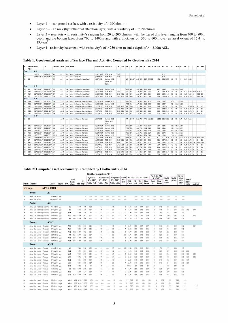
GeothermEx (2014) reviewed the TGE MT resistivity model and commented further as follows:
The MT data clearly suggests the presence of a low resistivity layer in the shallow subsurface of the type conventionally
considered to be the hydrothermal alteration cap over an extant or former geothermal reservoir
The possible reservoir areas as defined by the shallow resistivity anomaly extends somewhat to the NE of the survey area
and the outline shown of 14km2 could underestimate its extension in that direction. In contrast, the SE boundary and E
boundary of the anomaly is within the survey area but somewhat poorly defined (See Figure 6.)
Figure 6: Petrel Model of the MT data for the Apas Kiri Project showing MT resistivity cross sections, planned well pads
(red rectangles, spring sampling locations (blue spheres) and project roading. (From GeothermEx, 2014)
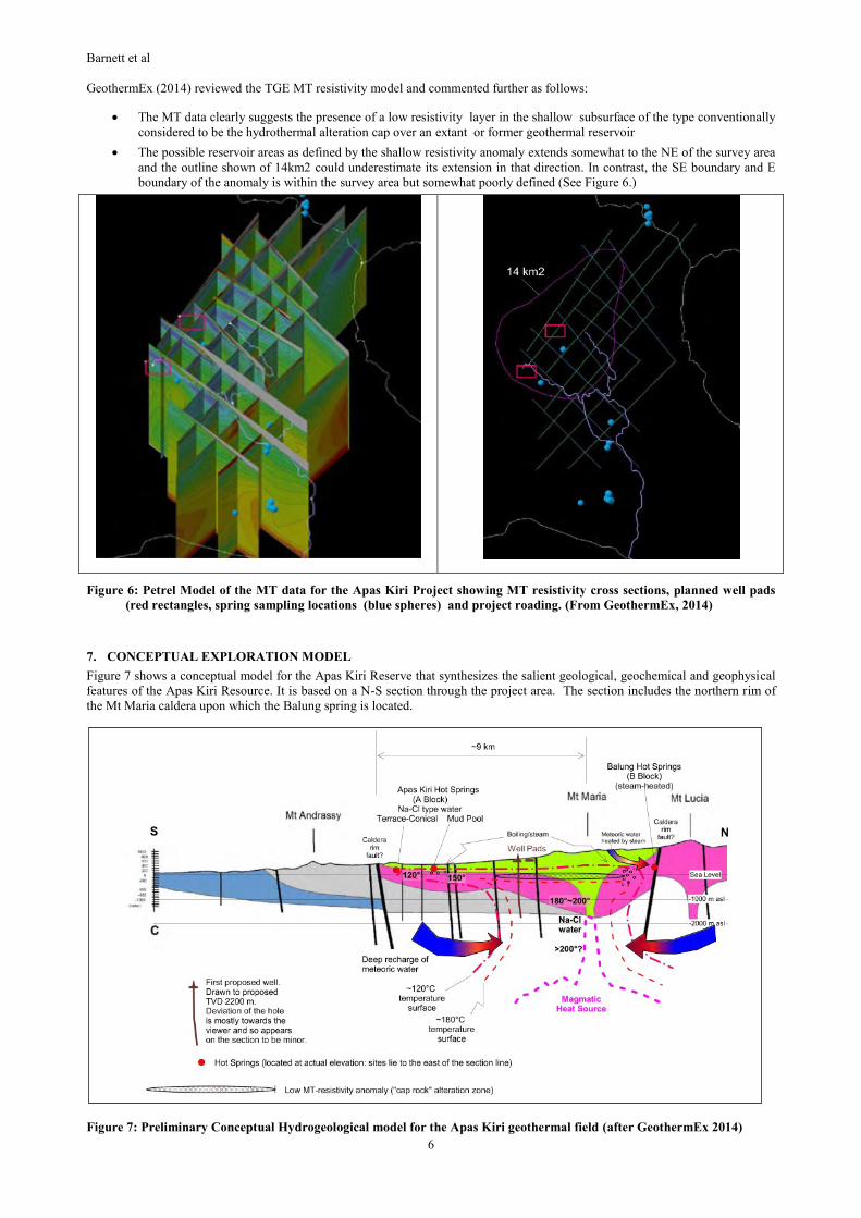
7. CONCEPTUAL EXPLORATION MODEL
Figure 7 shows a conceptual model for the Apas Kiri Reserve that synthesizes the salient geological, geochemical and geophysical
features of the Apas Kiri Resource. It is based on a N-S section through the project area. The section includes the northern rim of
the Mt Maria caldera upon which the Balung spring is located.
Figure 7: Preliminary Conceptual Hydrogeological model for the Apas Kiri geothermal field (after GeothermEx 2014)
Barnett et al
7
The geothermal resource is centered approximately under Mt Maria with an upflow temperature of 180 to 220oC. Minor outflow
occurs to the NE toward the steam heated Balung hot springs and a shallow plume of hot water with minor boiling flows to the
South with discharge at the mud pool and Apas Kiri springs. This southern plume is shown with a strong convective overturn and
with cooler water beneath it. The model might over emphasize this overturn but discharge plumes that are long and narrow like that
shown in Figure 7 have been well documented elsewhere. The flow to the hot springs occurs either along the contact between
younger Mt Maria volcanics and the older volcanics of Mt Lucia, and or within the Mt Lucia voclanics. It is mostly confined
beneath the lower resistivity anomaly, interpreted as a cap of hydrothermal alteration over the reservoir. The overall resource area is
conservatively estimated at 14 km2.
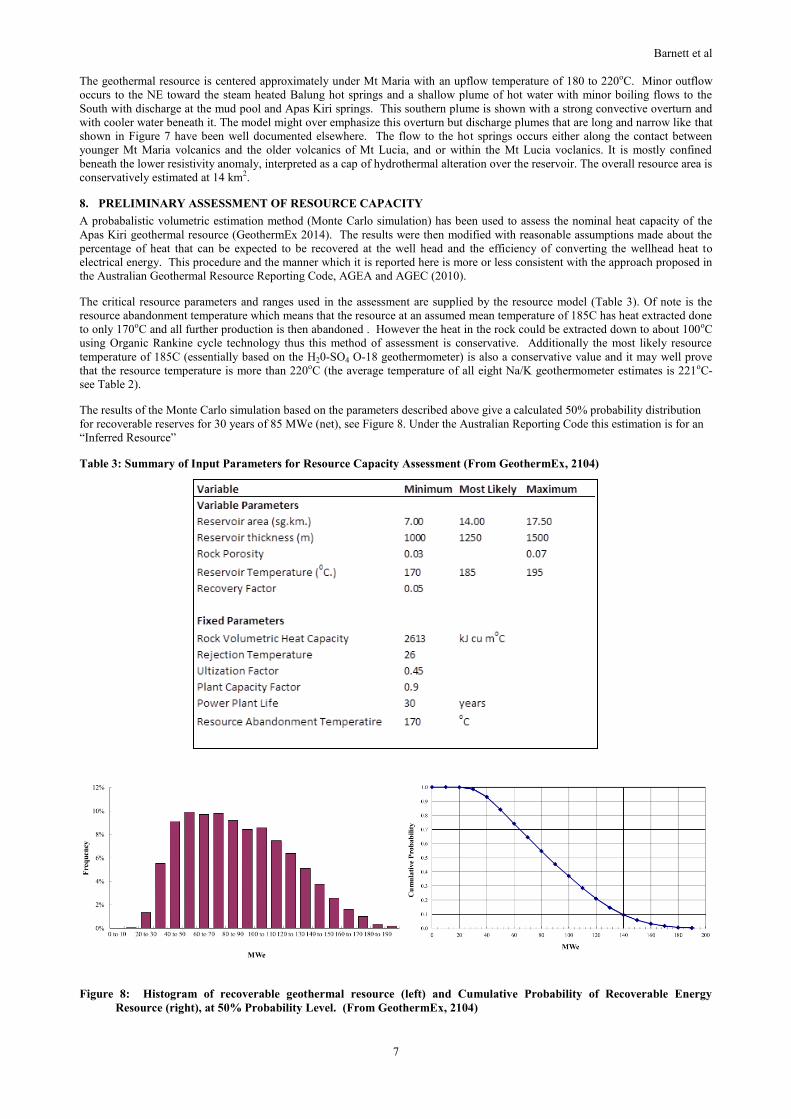
8. PRELIMINARY ASSESSMENT OF RESOURCE CAPACITY
A probabalistic volumetric estimation method (Monte Carlo simulation) has been used to assess the nominal heat capacity of the
Apas Kiri geothermal resource (GeothermEx 2014). The results were then modified with reasonable assumptions made about the
percentage of heat that can be expected to be recovered at the well head and the efficiency of converting the wellhead heat to
electrical energy. This procedure and the manner which it is reported here is more or less consistent with the approach proposed in
the Australian Geothermal Resource Reporting Code, AGEA and AGEC (2010).
The critical resource parameters and ranges used in the assessment are supplied by the resource model (Table 3). Of note is the
resource abandonment temperature which means that the resource at an assumed mean temperature of 185C has heat extracted done
to only 170oC and all further production is then abandoned . However the heat in the rock could be extracted down to about 100oC
using Organic Rankine cycle technology thus this method of assessment is conservative. Additionally the most likely resource
temperature of 185C (essentially based on the H20-SO4 O-18 geothermometer) is also a conservative value and it may well prove
that the resource temperature is more than 220oC (the average temperature of all eight Na/K geothermometer estimates is 221oC-
see Table 2).
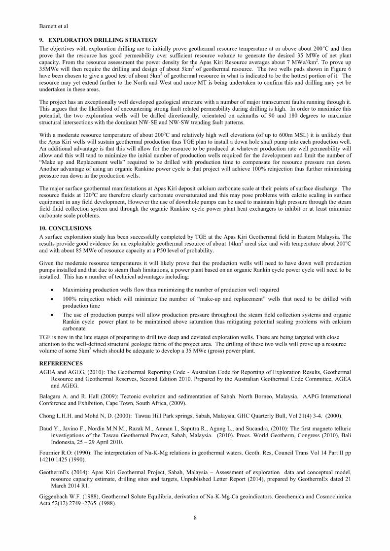
The results of the Monte Carlo simulation based on the parameters described above give a calculated 50% probability distribution
for recoverable reserves for 30 years of 85 MWe (net), see Figure 8. Under the Australian Reporting Code this estimation is for an
“Inferred Resource”
Table 3: Summary of Input Parameters for Resource Capacity Assessment (From GeothermEx, 2104)
Figure 8: Histogram of recoverable geothermal resource (left) and Cumulative Probability of Recoverable Energy
Resource (right), at 50% Probability Level. (From GeothermEx, 2104)
Barnett et al
8
9. EXPLORATION DRILLING STRATEGY
The objectives with exploration drilling are to initially prove geothermal resource temperature at or above about 200oC and then
prove that the resource has good permeability over sufficient resource volume to generate the desired 35 MWe of net plant
capacity. From the resource assessment the power density for the Apas Kiri Resource averages about 7 MWe//km2. To prove up
35MWe will then require the drilling and design of about 5km2 of geothermal resource. The two wells pads shown in Figure 6
have been chosen to give a good test of about 5km2 of geothermal resource in what is indicated to be the hottest portion of it. The
resource may yet extend further to the North and West and more MT is being undertaken to confirm this and drilling may yet be
undertaken in these areas.
The project has an exceptionally well developed geological structure with a number of major transcurrent faults running through it.
This argues that the likelihood of encountering strong fault related permeability during drilling is high. In order to maximize this
potential, the two exploration wells will be drilled directionally, orientated on azimuths of 90 and 180 degrees to maximize
structural intersections with the dominant NW-SE and NW-SW trending fault patterns.
With a moderate resource temperature of about 200oC and relatively high well elevations (of up to 600m MSL) it is unlikely that
the Apas Kiri wells will sustain geothermal production thus TGE plan to install a down hole shaft pump into each production well.
An additional advantage is that this will allow for the resource to be produced at whatever production rate well permeability will
allow and this will tend to minimize the initial number of production wells required for the development and limit the number of
“Make up and Replacement wells” required to be drilled with production time to compensate for resource pressure run down.
Another advantage of using an organic Rankine power cycle is that project will achieve 100% reinjection thus further minimizing
pressure run down in the production wells.
The major surface geothermal manifestations at Apas Kiri deposit calcium carbonate scale at their points of surface discharge. The
resource fluids at 120oC are therefore clearly carbonate oversaturated and this may pose problems with calcite scaling in surface
equipment in any field development, However the use of downhole pumps can be used to maintain high pressure through the steam
field fluid collection system and through the organic Rankine cycle power plant heat exchangers to inhibit or at least minimize
carbonate scale problems.
10. CONCLUSIONS
A surface exploration study has been successfully completed by TGE at the Apas Kiri Geothermal field in Eastern Malaysia. The
results provide good evidence for an exploitable geothermal resource of about 14km2 areal size and with temperature about 200oC
and with about 85 MWe of resource capacity at a P50 level of probability.
Given the moderate resource temperatures it will likely prove that the production wells will need to have down well production
pumps installed and that due to steam flash limitations, a power plant based on an organic Rankin cycle power cycle will need to be
installed. This has a number of technical advantages including:
Maximizing production wells flow thus minimizing the number of production well required
100% reinjection which will minimize the number of “make-up and replacement” wells that need to be drilled with
production time
The use of production pumps will allow production pressure throughout the steam field collection systems and organic
Rankin cycle power plant to be maintained above saturation thus mitigating potential scaling problems with calcium
carbonate
TGE is now in the late stages of preparing to drill two deep and deviated exploration wells. These are being targeted with close
attention to the well-defined structural geologic fabric of the project area. The drilling of these two wells will prove up a resource
volume of some 5km2 which should be adequate to develop a 35 MWe (gross) power plant.
REFEREENCES
AGEA and AGEG, (2010): The Geothermal Reporting Code - Australian Code for Reporting of Exploration Results, Geothermal
Resource and Geothermal Reserves, Second Edition 2010. Prepared by the Australian Geothermal Code Committee, AGEA
and AGEG.
Balagaru A. and R. Hall (2009): Tectonic evolution and sedimentation of Sabah. North Borneo, Malaysia. AAPG International
Conference and Exhibition, Cape Town, South Africa, (2009).
Chong L.H.H. and Mohd N, D. (2000): Tawau Hill Park springs, Sabah, Malaysia, GHC Quarterly Bull, Vol 21(4) 3-4. (2000).
Daud Y., Javino F., Nordin M.N.M., Razak M., Amnan I., Saputra R., Agung L., and Sucandra, (2010): The first magneto telluric
investigations of the Tawau Geothermal Project, Sabah, Malaysia. (2010). Procs. World Geotherm, Congress (2010), Bali
Indonesia, 25 – 29 April 2010.
Fournier R.O: (1990): The interpretation of Na-K-Mg relations in geothermal waters. Geoth. Res, Council Trans Vol 14 Part II pp
14210 1425 (1990).
GeothermEx (2014): Apas Kiri Geothermal Project, Sabah, Malaysia – Assessment of exploration data and conceptual model,
resource capacity estimate, drilling sites and targets, Unpublished Letter Report (2014), prepared by GeothermEx dated 21
March 2014 R1.
Giggenbach W.F. (1988), Geothermal Solute Equilibria, derivation of Na-K-Mg-Ca geoindicators. Geochemica and Cosmochimica
Acta 52(12) 2749 -2765. (1988).

Barnett et al
9
Jovino F., Suratman S., Pang Z., Choudhry, M.A., Caranto J., Ogena, M., and I Amnan (2010): Isotope and geochemical
investigations on Tawau Hot Springs in Sabah, Malaysia. Procs. World Geotherm, Congress (2010), Bali Indonesia, 25 – 29
April 2010.
Kirk, H.J.C; The Geology and mineral resources of the Semporna Peninsular, North Borneo, Borneo Geol. Survey Mem 14:178,
1962.
Santoyo E. and L. Dias-Gonzales (2010): A new improved proposal of the Na/K geothermometer to estimate deep equilibrium
temperatures and their uncertainties in geothermal systems, Procs. World Geotherm, Congress (2010), Bali Indonesia, 25 – 29
April 2010.
Takashima I., Nazri A.A., Siong L.P., Takahiro K., Mouri Y., Asnawir N., and I.G.N. Eddy Sucipto (2005): Precise
thermoluminescence dating for heat source volcanic rocks and alteration products at the Tawau geothermal Area, Sabah,
Malaysia, Procs. World Geotherm, Congress (2005), Anatalya, Turkey, 24 – 29 April 2005.
TGE (2013a): Magneto Telluric (MT) Prospecting, Geothermal Power Plant Project, Apas Kiri Geothermal Field, Final Report;
Tawau Green Energy Sdn. Bhd., December 2013 (unpublished Report).
TGE (2013b): Geology of Apas Kiri Geothermal Prospect, Tawau, Sabah, Malaysia; Final Report, Tawau Green Energy Sdn. Bhd.,
TGE Geothermal Power Plant Project, 2013 (unpublished Report).