geotechnical earthquake engineering - energy facility …...
TRANSCRIPT
g
Geotechnical Earthquake Engineering
Steven L. Kramer University of Washington
Prentice-Hall International Series in Civil Engineering and Engineering Mechanics
• Prentice Hall Upper Saddle River, New Jersey 07458
EX-0273-000002-TSS
es Chap. 2
Ltion of its epibut refinement is based on the
l seismograph. p- and s-wave 1e earthquake,
(2.2)
, and vp and Vs
ire generally 3 ·sec (1.2 to 3.1 al distance but 1ically by plotistance from a :ion of the epiy, a third seis' illustrated in tion are made the earth, and ~pends on the .ccuracy of the
Sec. 2.9 Size of Earthquakes 45
2.9 SIZE OF EARTHQUAl<ES
The "size" of an earthquake is obviously a very important parameter, and it has been described in different ways. Prior to the development of modern instrumentation, methods for characterizing the size of earthquakes were based on crude and qualitative descriptions of the effects of the earthquakes. More recently, modern seismographs have allowed the development of a number of quantitative measures of earthquake size. Since several of these measures are commonly used in both seismology and earthquake engineering, the distinguishing features of each should be understood.
2.9.1 Earthquake Intensity
The oldest measure of earthquake size is the earthquake inlensil). The inren ity is a qualitative de cri tion of the effects of the earthquake at a particular location as videnced by observed damage and human reactions at that location: Because qualitative de. criptions o the effects of earthquakes are available throughout recorded history, the concept of intensity can be applied to historical accounts to estimate the locations and sizes of earthquakes that occurred prior to the development of modern seismic instruments (preinstrumental earthquakes). This application has been very useful in characterizing the rates of recurrence of earthquakes of different sizes in various locations, a critical step in evaluation of the likelihood of seismic hazards. Intensities can also be used to estimate strong ground motion levels (Section 3.3.1.1 ), for comparison of earthquake effects in different geographic regions, and for earthquake loss estimation.
The Rossi-Fore! (RF) scale of intensity, describing intensities with values ranging from I to X, was developed in the 1880s and used for many years. It has largely been replaced in English-speaking countries by the modified Mercalli intensity (MMI) scale originally developed by the Italian seismologist Mercalli and modified in 1931 to better represent conditions in California (Richter, 1958). The MMI scale is illustrated in Table 2-1. The qualitative nature of the MMI scale is apparent from the descriptions of each intensity level.
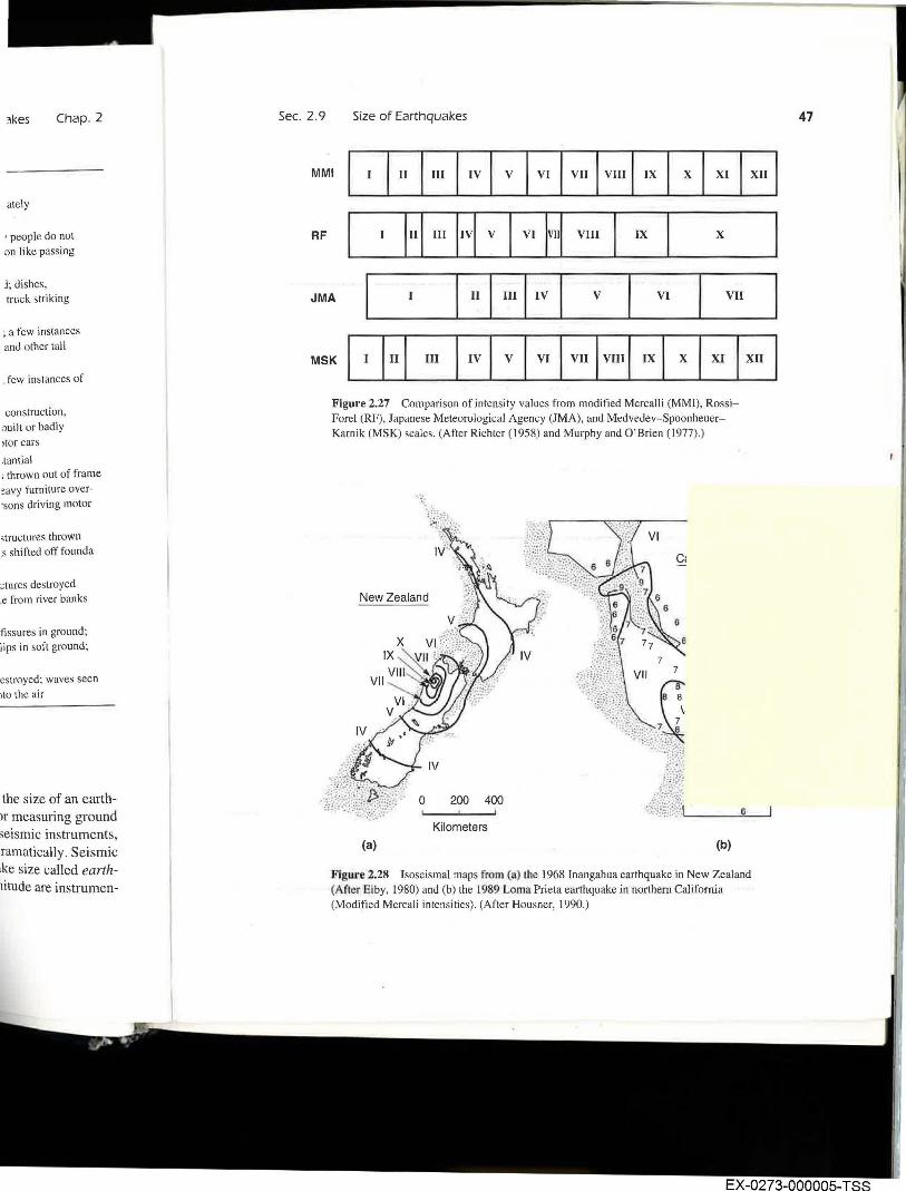
The Japanese Meteorological Agency (JMA) has its own intensity scale, and the Medvedev-Spoonheuer-Karnik (MSK) scale is used in central and eastern Europe. A comparison of the RF, MMI, JMA, and MSK scales is shown in Figure 2.27.
Earthquake intensities are usually obtained from interviews of observers after the event. The interviews are often done by mail, but in some seismically active areas, permanent observers are organized and trained to produce rational and unemotional accounts of ground shaking. Since human observers and structures are scattered more widely than any seismological observatory could reasonably hope to scatter instruments, intensity observations provide information that helps characterize the distribution of ground shaking in a region. A plot of reported intensities at different locations on a map allows contours of equal intensity, or isoseisms, to be plotted. Such a map is called an isoseismal map (Figure 2.28). The intensity is generally greatest in the vicinity of the epicenter of the earthquake, and ,the term epicentral intensity is often used as a crude description of earthquake size . Isoseismal maps show how the intensity decreases, or attenuates, with increasing epicentral distance.
46
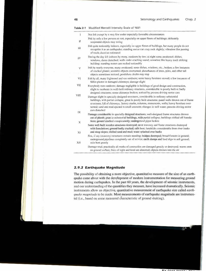
Table 2-1
II
III
IV
v
VI
VII
VIII
IX
x
XI
XII
Seismology and Earthquakes
Modified Mercalli Intensity Scale of 1931
Not felt except by a very few under especially favorable circumstances
Felt by only a few persons at rest, especially on upper floors of buildings; delicately
suspended objects may swing
Chap. 2
Felt quite noticeably indoors, especially on upper floors of buildings , but many people do not
recognize it as an earthquake; standing motor cars may rock slightly; vibration like passing
of truck; duration estimated
During the day felt indoors by many, outdoors by few; at night some awakened; dishes, windows, doors disturbed; walls make cracking sound; sensation like heavy truck striking
building; standing motor cars rocked noticeably
Felt by nearly everyone, many awakened; some dishes, windows, etc., broken; a few instances
of cracked plaster; unstable objects overturned; disturbances of trees, piles, and other tall
objects sometimes noticed; pendulum clocks may stop
Felt by all, many frightened and run outdoors; some heavy furn iture moved; a few instances of
fallen plaster or damaged chimneys; damage slight
Everybody runs outdoors ; damage negligible in buildings of good design and construction,
slight to moderate in well-built ordinary structures, considerable in poorly built or badly
designed structures; some chimneys broken; noticed by persons driving motor cars
Damage slight in specially designed structures, considerable in ordinary substantial
buildings, with partial collapse, great in poorly built structures; panel walls thrown out of frame
structures; fall of chimneys, factory stacks, columns, monuments, walls; heavy furniture overturned; sand and mud ejected in small amounts ; changes in well water; persons driving motor
cars disturbed
Damage considerable in specially designed tructures; well-designed frame structures thrown
out of plumb; gre~u in substantial buildings. with partial collapse; buildings shifted off founda
lions; ground crncked conspicuou ly: unde rground pipes broken
Some we ll-built wooden stmctures destroyed: most masonry and frame structures destroyed
wilh foundmions; ground badly cracked: mils bent; landslides considerable from river banks
and sleep lope ; shined sand and mud; water splashed over hanks
Few, if any (masonry) structures remain standing; bridges destroyed; broad fissures in ground;
underground pipelines completely out of service; eurth slumps nnd land slips in soft ground;
rai ls bent greatly
Damage total ; practically all works of contruction are damaged greatly or destroyed; waves seen on ground surface; lines of sight and level are distorted; objects thrown into the air
2.9.2 Earthquake Magnitude
The pos ibility of obtaining a more objective, quantitative mea ure of the size of an earrhq_uake came about with lhe de.v~lopment of modern in trumentation for measuring ground motion during earthquake . In lhe past 60 year , the development of seismic in truments, and our understanding of the quantities they mea ure, have increased dramatically. Sei mic instruments allow an objective, quantitative measuremeiH of earthquake size called earthquake magnitude to be made. Most measurements of earthquake magnitude are instrumental (i.e., based on some measured characteristic of ground shaking).
~kes Chap. 2
ately
• people do not on like passing
j; dishes, truck striking
; a few instances and other tall
few instances of
construction, ~uilt or badly >tor cars
.tan ti al ; thrown out of frame !avy furn iture over·sons driving motor
>tructures thrown .s shifted off founda-
~tures destroyed .e from river banks
fissu res in ground; lips in soft ground;
estroyed; waves seen ito the air
·the size of an earthor measuring ground seismic instruments, lramatically. Seismic ake size called earthnitude are instrumen-
Sec. 2.9 Size of Earthquakes
MMI I I I II I III I IV I v I VI I VII I VIU I IX I x I XI I XU I
RF I H III H v I VI H Vlll I IX I x I JMA I I I II I ml IV I v I VI I VII I MSK I I H III I IV I v I VI I vu I vm J ~ I x I XI I Xll I
Figure 2.27 Comparison of intensity values from modified Mercalli (MMI), RossiForel (RF), Japanese Meteorological Agency (JMA), and Medvedev-SpoonheuerKarnik (MSK) scales. (After Richter (1958) and Murphy and O'Brien (1977).)
.. ;',
New Zealand
0 200 400
Kilometers
(a) (b)
6
Figure 2.28 Isoseismal maps from (a) the 1968 Inangahua earthquake in New Zealand (After Eiby, 1980) and (b) the 1989 Loma Prieta earthquake in northern California (Modified Mercali intensities). (After Housner, 1990.)
47
EX-0273-000005-TSS