georeference and digitalization of the cartographic collections of
TRANSCRIPT
e-Perimetron, Vol. 5, No. 4, 2010 [212-225] www.e-perimetron.org | ISSN 1790-3769
[212]
Wiesława śyszkowska∗, Ewa Szynkiewicz**, Anna Osowska*** and Dariusz Przybytek****
Georeference and digitalization of the cartographic collections
of the University of Wrocław
Keywords: georeferencing; digitalization; electronic catalog; digital libraries; map circulation.
Summary: The inventory-catalog application of the map collections of the University of Wrocław is a georeferenced database containing information about the cartographical documents collected in different departments of the University. This catalog completely changes the way of using the cartographic collections and allows increasing their avail-ability by shortening the time needed to obtain information about them. Records entered in the database with geographical coordinates are retrieved on a scaled map based on given search terms, among which the most important is georeference. This makes the use of this application easy. The peculiarity of the cartographic collection and especially the map se-ries makes it essential to create indexes and coverage of maps. The application is com-patible with the University of Wroclaw Digital Library, as the process of digitizing maps and plans has recently started. This paper describes chosen features of the newly created application and first experiences with using it to support librarian’s work and reader’s needs. The conclusion drawn is that the idea of creating one consistent system that delivers full information about all carto-graphic materials collected in the University will be of benefit in the future.
Introduction
The cartographic collection of the University of Wrocław is kept in three separate places, so it can be considered to comprise three smaller collections, which differ in terms of their origin, nature and subject. These collections include: maps and atlases kept at the Maps Department of the Wro-cław University Library, cartographic documents at the Department of Cartography of the Insti-tute of Geography and Regional Development and some geological maps stored in the Library of the Institute of Geologic Studies. The historical and informational value of these map collections is the reason why it is important to make them available to the widest range of users, especially by using modern computer tech-niques. The paper will consider the first two collections, particularly problems and possibilities associated with their cataloging and digitalization.
The cartographic collection of the Wrocław University Library The Maps Department of the Wrocław University Library was established in 1949 as one of sev-eral special collections. The initial collection consisted of the remains of the map collections of
∗ Professor, Head of the Department of Cartography, Institute of Geography and Regional Development, Uni-versity of Wrocław [[email protected]] ** Certified Documentalist and Cartographer, Department of Cartography, Institute of Geography and Regional Development, University of Wrocław [[email protected]] *** Cartographer, Maps Department, Wrocław University Library [[email protected]] **** PhD, Historian, Head of the Maps Department, Wrocław University Library [[email protected]]

e-Perimetron, Vol. 5, No. 4, 2010 [212-225] www.e-perimetron.org | ISSN 1790-3769
[213]
the pre-war university library, the municipal library (the municipal library held the map collec-tions of three libraries belonging to it: the St. Elizabeth’s church library, the St. Mary’s and the St. Madeleine’s church library and the St. Bernadine’s church library), from the collections of pre-war grammar schools, Silesian provincial libraries as well as from private collections. At present, the collection consists of nearly 13 000 cataloged items in more than 21 000 units, in-cluding more than 8 000 sheets of various map series. The profile of the cartographic collection, just like that of the entire library, is characterized by two factors: map and atlas origin and their current geographical location, which means specialization in Silesiaca, Lusatica and Germanica as well as Polonica after the Second World War. A dozen of old atlases, that were published at the end of the 18th century are extremely valuable, especially the so-called factice atlases. The most valuable item in the collection is the unique factice atlas which belonged to Zaharias and Ama-deus Machnizky, entitled Atlantis Cosmographici Variorum Autorum a Machnizkiis collecti – it includes around 1 000 maps, plans, views and drawings by various authors, bound into 7 volumes (each of which represents a different region). Other unique items are: a map of Russia from 1562 by Anthony Jenkinson, a wood engraving view of Prague from 1561 and very rare and large Mappe-Monde nouvelle Papistique, published in 1566. More about the collection can be found in publications by Szykuła (1978, 1992), the former head of the Department. Until recently only an alphabetical card catalog was in use, which was later scanned and posted on the library website as an online public access catalog. The bibliographic description on a single catalog card comprises three elements: the geographical name, the indicator of the map, plan or view type and the date of publication or print. A digitalized catalog entry consists only of the main and reference cards with geographical names. A catalog of reference cards of authors and types of maps, plans and views, as well as of the views, plans themselves and all kinds of reproductions is only available in the Reading Room of the Maps Department. On 31.12.2006 the alphabetical card catalog was closed. Information regarding collections that was acquired and processed after 1.01.2007 is to be found only in the electronic catalog of the Wroclaw University Library (biblio-graphic description in accordance to the MARC 21 Bibliographic Format are used in the OPAC Catalog). The willingness to improve and shorten the time needed to obtain information about a particular map or atlas contributed to the fact that library staff (cartographer, historian and two IT specialists) decided to create and implement an additional electronic catalog, using coordinates as the primary search criterion.
The Cartographic collection of the Department of Cartography
in the Institute of Geography and Regional Development
The cartographic collection in the Institute of Geography and Regional Development is associated with the Department of Cartography. This is due to the subject of the cartographic documents, which corresponds to the interests of the Department and can be traced back to the origin of the collection. The collection was created from privately owned maps and atlases brought to Wrocław by migrants from Lwów. The remaining cartographic documents in the collection are maps and atlases found in the region of Silesia and brought together at the University of Wrocław. Antique maps and modern documents can be found in the collection. Together the collection comprises 50 000 cataloged items. The accumulated maps and atlases are a valuable resource for teaching and research- modern topographic maps, theme maps, general atlases, school atlases, theme atlases, tourist maps and city maps. Several are most worth mentioning:

e-Perimetron, Vol. 5, No. 4, 2010 [212-225] www.e-perimetron.org | ISSN 1790-3769
[214]
The Contrafaktur der Stadt Bresslau, a plan of Wrocław, the work of father and son Bart(h)l Wei(h)ner dating back to 1562 is considered to be the oldest item in the collection. The plan in the collection of the Institute of Geography is not the original of the plan but a precise copy, created in 1826 in honor of the coronation of Maximilian Habsburg II. It is a very precious resource for historical studies. A document of which the original is held at the university is one of six volumes of the 16th century Georg Braun and Frans Hogenberg atlas Civitates orbis terrarum. The collec-tion also holds 11 volumes of the great Atlas maior published by Blaeu (the Blaviana Publishing House) a work from the era of great Dutch cartography. Polish and German cartography is predominant in the 18th century part of the collection. A map that ought to be mentioned among these works is the first map of Poland, published in Paris, en-tirely based on local measurements (Saint Hillers, Franciszek Czaki, Antoni Rizzi-Zannoni 1772). The Atlas Silesiae is, for Silesia, the most precious work of the period. It was published by Homann Publishing House in Nürnberg in 1750 and holds detailed maps of the Silesian prince-doms by Wieland and Schubart. Two publishing houses dominate the 19th century private cartog-raphy – Korn from Wrocław and Flemming from Głogów. All cartographic documents published by Gottlob Reymann can be found in the collection. Most of the maps held are German maps in the following scales: 1:25.000, 1:100.000, 1:200.000, and 1:300.000 (covering all of Silesia). Austrian maps in scales 1:75.000 and 1:200.000 are pre-sent and there is a rich selection of Russian ones in 1:126.000. The 20th century is a new era in Polish cartography. Eugeniusz Romer is the father of modern school cartography, the founder of the Institute of Cartography and the KsiąŜnica-Atlas publishing house in Lwów. Our library owns the richest collection of Eugeniusz Romer’s cartographic documents in Poland and full map coverage of Poland by the Military Institute of Geography (Woj-skowy Instytut Geograficzny) from 1919-1939. The diversity of the cartographic documents in the collection in the Department of Cartography is a result of their history, qualities and the functions that they fulfill. They are cataloged in a tradi-tional method – the catalogs are available in printed form or as sheet indexes in case of map se-ries. Only recently some maps (ca 3 000 items) were processed in MARC 21 format and are avail-able in digital form.
The electronic catalog of the map collection
A problem, which occurred during the updating of map series index sheets, brought about the idea of creating a new, electronic catalog. The problem that occurred concerned especially two groups of maps: contemporary topographic maps of Poland published at different scales and pre-war to-pographic maps. These are the most requested by readers. It meant that at least 9 sheet indexes containing thousands of sheets were to be revised and even re-drawn. Hence the map librarians from the Wrocław University Library developed a concept to improve them, giving up paper ones and creating one complete electronic catalog. The initial concept assumed that there is need to create an application that should combine the catalog with the inventory (accession list), but only for chosen maps. While the work was in pro-gress it proved, that it could be extended also to other objects – single atlases, maps and views. By adding more features one multifunctional application was created, and today it is a catalog, inven-tory and circulation manager, supporting almost all needs of the Maps Department. The main part of the application is a database that stores descriptions of cataloged objects (maps, atlases, views etc.) and their coordinates. In order to better interact with the user (without the need
e-Perimetron, Vol. 5, No. 4, 2010 [212-225] www.e-perimetron.org | ISSN 1790-3769
[215]
to reload the page for every change of parameters) it uses the latest Internet technologies such as AJAX. To approximate the georeference the application uses the Google Maps service (based on the Mercator projection), which enables visualization of maps coverage, as well as advanced search based on selected criteria. Programming, testing and entering the first five hundreds re-cords took almost a year. The application consists of two modules. To enter or edit data the editor’s module is used. It in-cludes all the necessary tools, created to meet all the editor’s needs. The basic features are: creat-ing and editing records, searching records, managing dictionaries of various terms, managing reader’s accounts, managing circulation status of items available for readers in the Reading Room of the Maps Department, creating reports and statistics. The second module is dedicated to read-ers. It allows searching the entire collection and requesting chosen items to the reading room. Since 1.07.2009 the electronic catalog, being part of the inventory-catalog application, has been fully accessible at www.bu.uni.wroc.pl/ozk . Since then, the current organization of work in the department has changed – the printed inventory has been closed and the module that allows read-ers to request items through the internet has improved the process of circulating the collection. In the first half of August, map librarians from the Department of Cartography in the Institute of Ge-ography and Regional Development started to input records concerning maps from their collec-tion.
Entering and editing data – the editor’s module
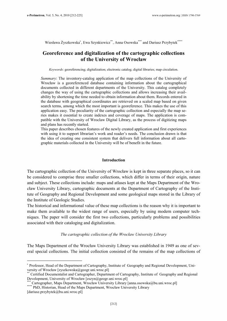
Entering data may be carried out in two ways: using the worksheet available in the “Records” menu of the editor’s module or by importing metadata from the MARC 21 bibliographic descrip-tion for items that were cataloged earlier in the OPAC Catalog of the Wrocław University Library (Fig. 1).
Figure 1. The editor’s module interface. In the menu from the left: Records (marked, active), Dictionaries,
Readers, Circulation, Reports, Statistics and Import (marked).

e-Perimetron, Vol. 5, No. 4, 2010 [212-225] www.e-perimetron.org | ISSN 1790-3769
[216]
The form makes it possible to create inventory-catalog description easily and quickly. When the editor inputs a new record, the first step to make is choosing one of three types of the cartographic material – depending on which type one chooses the form is a bit different (certain fields may be disabled). It allows to differentiate between map series as a whole, individual sheets and single maps and atlases. The full map series record form consists of the following fields to fill: shelf mark, title, scale, place of publication, name of publisher, type of cartographic document, keywords and notes. This metadata is the same for each map series as a whole; individual sheets are supplemented by details such as: sheet title, sheet designation, coordinates, number of pieces, accession number, year of publication, year of edition, date of updating the content of the map, datum, URL to Digital Li-brary of Wrocław University (if the item is digitized), price, status of the item, notes about preser-vation and other notes (Fig. 2). The third record type – for single maps, views and atlases – con-tains the same fields except for defining ones, like sheet title or designation. It is also extended by the series statement field.
Figure 2. The form of an individual sheet of a map series. Example: the part of one of 3974 sheets
of a Topographic map of Poland 1:10.000 entered to the database.
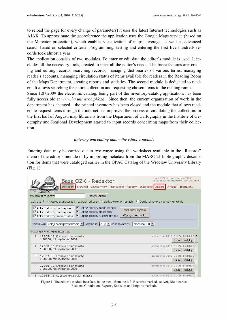
Among the fields that need data typed in, there are special ones, for which values are input by us-ing pre-defined lists of values, so-called dictionaries. With this solution there is also the possibil-ity of defining synonyms (or similar words) for individual words or phrases (Fig. 3) and supervis-ing the consistency of descriptions. There are six (6) separate dictionaries for the terms that are
e-Perimetron, Vol. 5, No. 4, 2010 [212-225] www.e-perimetron.org | ISSN 1790-3769
[217]
repeated frequently, such as: types or forms of cartographic material, keywords, places of publica-tion, series, dates and names of publishers.
Figure 3. The Dictionaries manager window. The image shows: 1. Choosing the dictionary (example: the dictionary of key-words chosen), 2. Terms (example: phytogeography selected), 3. Synonyms of selected term (example: botany, flora, vegeta-
tion, plant distribution).
Metadata can be also input by using the import from MARC 21 Bibliographic Format. The proper fields have been mapped so data taken from the MARC 21 record move directly to the record in the database and the entire process is based on a default configuration built-in inside the applica-tion. It is possible to import fields from MARC 21 bibliographic records as well as from item re-cords, so a new created record requires only a small correction and additional notes. In this way the inventory arises semi-automatically using the data entered in the cataloging. There are at least three advantages of this procedure. Most of all it allows to save the time of the editor by eliminat-ing the double data entry. The second benefit is the verification of the correctness of the carto-graphic mathematical data (especially field 034), as in the case of incorrect coordinate form or values the map coverage does not display on the Google Map. Thirdly, it allows to improve the presentation of bibliographical description in OPAC Catalog of the Wrocław University Library, supplementing it with the visualization of map coverage – visible, when there are coordinates coded properly in the 034 field (Fig. 4). The above example shows that the coordinates can be very important and useful data for map librarians as well as for map readers.

e-Perimetron, Vol. 5, No. 4, 2010 [212-225] www.e-perimetron.org | ISSN 1790-3769
[218]
Figure 4. A bibliographic description of the map in OPAC Catalog of the Wrocław University Library showing the proper coverage depending on metadata in 034 field of MARC 21 bibliographic format (Coded Cartographic Mathematical Data).
Georeferencing
It should be noted that when considering the application the term georeference is understood as determining the spatial location of map coverage (according to map content). The other com-monly used meaning of that word – i.e. establishing the relation between raster or vector image
e-Perimetron, Vol. 5, No. 4, 2010 [212-225] www.e-perimetron.org | ISSN 1790-3769
[219]
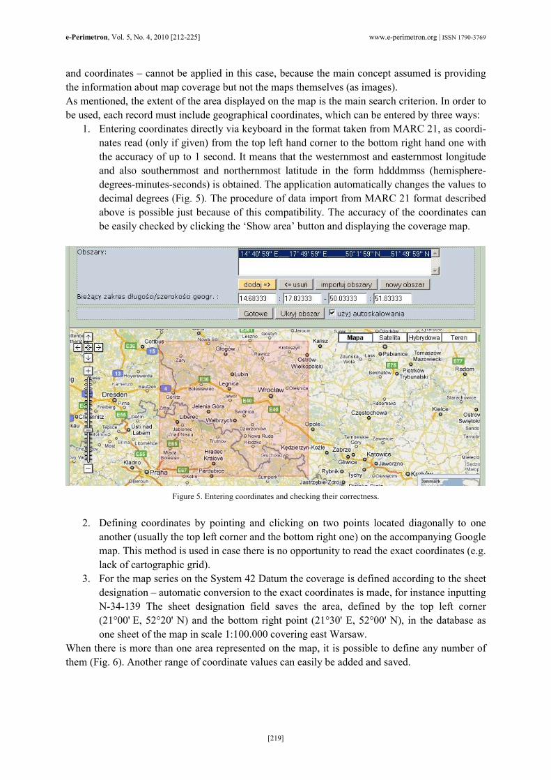
and coordinates – cannot be applied in this case, because the main concept assumed is providing the information about map coverage but not the maps themselves (as images). As mentioned, the extent of the area displayed on the map is the main search criterion. In order to be used, each record must include geographical coordinates, which can be entered by three ways: 1. Entering coordinates directly via keyboard in the format taken from MARC 21, as coordi-nates read (only if given) from the top left hand corner to the bottom right hand one with the accuracy of up to 1 second. It means that the westernmost and easternmost longitude and also southernmost and northernmost latitude in the form hdddmmss (hemisphere-degrees-minutes-seconds) is obtained. The application automatically changes the values to decimal degrees (Fig. 5). The procedure of data import from MARC 21 format described above is possible just because of this compatibility. The accuracy of the coordinates can be easily checked by clicking the ‘Show area’ button and displaying the coverage map.
Figure 5. Entering coordinates and checking their correctness.
2. Defining coordinates by pointing and clicking on two points located diagonally to one another (usually the top left corner and the bottom right one) on the accompanying Google map. This method is used in case there is no opportunity to read the exact coordinates (e.g. lack of cartographic grid).
3. For the map series on the System 42 Datum the coverage is defined according to the sheet designation – automatic conversion to the exact coordinates is made, for instance inputting N-34-139 The sheet designation field saves the area, defined by the top left corner (21°00' E, 52°20' N) and the bottom right point (21°30' E, 52°00' N), in the database as one sheet of the map in scale 1:100.000 covering east Warsaw.
When there is more than one area represented on the map, it is possible to define any number of them (Fig. 6). Another range of coordinate values can easily be added and saved.

e-Perimetron, Vol. 5, No. 4, 2010 [212-225] www.e-perimetron.org | ISSN 1790-3769
[220]
Figure 6. An example of the records with two and four areas defined.
Because the database is defined by four pairs of coordinates making a rectangle, in case of an area with irregular boundaries or separate locations it is possible to display it with a better approximation.
Searching the electronic catalog – the reader’s module
The electronic catalog, available at www.bu.uni.wroc.pl/ozk is very easy to use. This catalog com-pletely changes the way of using the cartographic collections and allows increasing their availabil-ity by shortening the time needed to obtain information about them. The location of the point is the primary search criterion. By selecting the menu “Search on the map” and clicking on the point on the Google map one can get a list of all searched, potentially interesting items (Fig. 7). There is also possibility to search for a specified place by writing a city, town or village name in the left bottom corner of the map.
Figure 7. The result of searching for Wrocław.
To narrow the search to a particular type of item, publication date or location, one should click on the “Show criteria” feature. The icon “Show area” from the list of searched items displays the coverage of the chosen map as well as “Details” displays full catalog description (Fig. 8). It

e-Perimetron, Vol. 5, No. 4, 2010 [212-225] www.e-perimetron.org | ISSN 1790-3769
[221]
should be noted that in each description there is the permalink field, where the URL referring to the item is given.
Figure 8. An example of catalog description. The “Show area” is active.
To perform a search using the elements of the map bibliographic description one should select the menu “Search in index” and enter advanced search criteria such as: title, shelf mark, sheet name, sheet designation or keyword (Fig. 9). Optionally, there is a possibility to narrow the search as previously described. This is needed when searched lists exceed 500 hits.
Figure 9. An advanced search criteria form.

e-Perimetron, Vol. 5, No. 4, 2010 [212-225] www.e-perimetron.org | ISSN 1790-3769
[222]
A third way to search (for map series only) is to browse sheet indexes. After choosing the proper title from the scroll down menu, the sheet index is being displayed on the overall map. After clicking on the chosen sheet the catalog description appears on the right side (Fig. 10).
Figure 10. An example of sheet index – The Hydrographic Map of Poland 1:50.000.
Regardless of the selected search method, every registered user can request the item to the reading room. By choosing “My account” from the top menu, the user can view the list of cur-rent orders. A short guide describing how to use the electronic catalog and managing the ac-count is in the “Help” menu.
Main problems so far and plans for further development
While work on the application was being carried out, many problems connected with aspects of its functioning occurred. Part of them has been solved successfully, the rest are currently in the proc-ess of being solved. The first group of problems includes the possibility of saving more than one extent of the same map in one record and managing the dictionary of terminology. Another key issue was also mak-ing it possible to distinguish records of independent objects (such as maps, atlases and views) from sheets of map series, which are classified according to the entire map series to which they belong. The next concern is marking the localization of objects that are fed into the database. The task, which has priority at the moment, is the method of marking and displaying records- that are currently cartographic documents from all over the world. Defining coordinates, like in case of records with defined areas is incorrect, as this doesn’t allow Google map to display the correct map extent. Attempts are currently being made to create a rep-resentation of the whole world divided into smaller sections, but the procedure has not been en-tirely tested to date. Another useful function will be adding the option of directly saving the bibliographic description of the accessed object in a format convenient for further use and editing (e.g. pasting it into a text or bibliography). It ought to be emphasized that this application was created as a result of intense cooperation be-tween the IT specialists and staff responsible for the collection. This cooperation made it possible to create this highly useful tool, which can be developed and modified when the need arises in the future.

e-Perimetron, Vol. 5, No. 4, 2010 [212-225] www.e-perimetron.org | ISSN 1790-3769
[223]
Digitalization
The automatization of the functioning of libraries, the creation of optical discs and the develop-ment of the global telecommunications network created a whole range of new opportunities for libraries in collecting works and consequently making them available, regardless of the distance dividing the reader from the source. The application of new technologies led to the creation of databases, online library catalogs and research databases which offer access to internal resources of a given institution as well as links to external sources. Systematic degradation of printed resources through use and the awareness of the loss of these documents have led to the use of modern techniques of transferring and sharing information in the preservation of collections of cartographic documents. Thanks to computer technology copies of documents can be produced simultaneously preserving the quality of the original. According to the Encyclopedia of Library and Information Science, 2008 “Digitalization is the process of converting analogue data into digital form, using a scanning device or a digitalizer” Digitalization in library science refers to the process of inputting traditional library materials into a computer’s memory using scanning techniques. A significant process that follows scanning is digital processing, which makes it possible to make the scanned publication part of a digital li-brary. The goal of digitalization is archiving in libraries, protection of the original, reviewing the re-sources, making them available and registering them. The growing amount of published materials, the degradation of library resources by chemical and microbiological factors as well as the de-structive human interference all lead to the fact that safety and protection of documental heritage has become a priority nationwide and worldwide in the handling of collections. As digitalization is extremely time consuming and requires a lot of work input as well as financial input the selection of documents which are to undergo this process is of utmost importance. The selection criteria are: 1. The date when the document was created. 2. The uniqueness of the document. 3. The value of the document for the national culture. 4. The importance of the document for the regional history (e.g. Silesia) 5. The input of the document into the European and World heritage.
The cartographic materials in the Digital Library of the University of Wrocław
In the University Library in Wrocław the main aim of digitalization was to increase the access to the special collections by making them available in the form of digital copies. The originals were gradually withdrawn from circulation thanks to this process. In 2005 the Digital Library of Wrocław University was formed. Since December 2009 its re-sources can be viewed in Europeana, one of Europe’s most popular internet services. The Digital Library of Wrocław University gives access to 24 thousand documents on the Europeana, making it the fourth largest digital library in Poland. “Cartographic Materials” are classified as a separate group in the library’s “Cultural Heritage” collection. The documents include digital versions of atlases, maps, plans and views of cities. Cur-rently 132 publications can be found. The process of digitalization of the collection has begun with the digitalization of the already mentioned factice atlas of the Machnizky family, starting

e-Perimetron, Vol. 5, No. 4, 2010 [212-225] www.e-perimetron.org | ISSN 1790-3769
[224]
from its fifth volume which contains maps, plans and views of Silesia, Bohemia, Moravia and Lu-satia- regions which are of primary interest to readers. The main problem encountered during the digitalization of the atlas was its size. Most of its maps are larger than an A2 format. The University Library does not possess a scanner larger than A2. Furthermore Volume 5 of the atlas contains 165 maps, which made it extremely difficult to scan the maps from a bound volume. Due to this a decision was made to unbind the atlas, which made it possible to scan each map separately, unfolded. The Special Collections’ Conservation Work-shop of the library took advantage of the fact that the atlas was unbound and the sheets underwent conservation; tears and damage were fixed and the atlas was cleaned.
Figure 11. An example of a map from the “Cartographic Materials” collection in the Digital Library of Wrocław University.
The link to the inventory-catalog application marked.

e-Perimetron, Vol. 5, No. 4, 2010 [212-225] www.e-perimetron.org | ISSN 1790-3769
[225]
The maps were scanned with a resolution of 600 DPI and saved in a TIFF format. Presentation files that are available in the digital library are converted to DjVu format, the advantage of which is small size with a simultaneous maintenance of high quality and the ability to use OCR. In order to maintain the physical structure of a factice atlas in the digital library, a group publica-tion was formed in which single maps were included to mimic the original publication. The de-scription of each map, in accordance with the Dublin Core (version 1.1), consists of the following metadata: title, author, subject and keywords, description, publisher, place of publishing, co-author (optional), date of publishing, type of resource, format, source, language. In addition to this a link to the inventory catalog application was created (Fig. 11) which redirects the reader from the document in the digital library to the corresponding catalog entry. Thanks to this the reader can quickly find out what area the given map covers. The link is available in the field “links”.
Conclusion
The project of bringing together the information about the various parts of the cartographic collec-tion in one digital application is the first and very important step in making the collection of price-less Silesian cartographics available to a wider group of people, organizing them and making them known all over the world. We are aware that the work begun will take years to complete, however we appreciate that the project reflects the global tendency to process and to make cartographic collections available to the public. We acknowledge that with the development of the technology available in forming digital libraries it will be necessary to organize our work in order to set priorities on a national and on a European scale to ensure that we do not repeat something already done. As resources are be-coming more available on the World Wide Web, the number of its users is naturally increasing; therefore the noble idea of creating public libraries with free access is becoming increasingly more significant.
References
Kowalska, M., 2007. Digitalizacja zbiorów bibliotek polskich. Seria: Nauka – Dydaktyka – Praktyka. Warszawa : Wydawnictwo SBP.
Library of Congress Network Development and MARC Standards Office. MARC 21 Format for Bibliographic Data. 1999 Edition Update No. 1 (October 2001) through Update No. 10 (October 2009). Viewed 20 January 2010, http://www.loc.gov/marc/bibliographic
Przybytek, D., 2009. Georeferencyjna aplikacja inwentarzowo-katalogowa zbiorów kartogra-ficznych UWr. Przegląd Uniwersytecki 5: 30.
Szykuła, K., 1978. Zbiory kartograficzne Biblioteki Uniwersyteckiej we Wrocławiu. Wrocław: Wydawnictwo Uniwersytetu Wrocławskiego.
Szykuła, K., 1992. The Cartographic Collection of the Wroclaw University Library – its Nature, and Usefulness for Readers. The LIBER Quarterly 2 (1). Viewed 20 January 2010, http://liber-maps.kb.nl/articles/szykula6.html
Szynkiewicz, E., 2007. Zbiory kartograficzne Zakładu Kartografii Instytutu Geografii i Rozwoju Regionalnego Uniwersytetu Wrocławskiego. Z problemów bibliotek naukowych Wrocławia, t. 4. Kolekcje kartograficzne Uniwersytetu Wrocławskiego. Wrocław : Wydawnictwo TArt.
The Imagining & Geospatial Information Society ASPRS online. Grids & Datums of the World. Viewed 20 January 2010, http://www.asprs.org/resources/grids/09-2000-poland.pdf