geomorphological heritage of the pyrenees national...
TRANSCRIPT

ORIGINAL ARTICLE
Geomorphological Heritage of the Pyrenees National Park(France): Assessment, Clustering, and Promotionof Geomorphosites
Thierry Feuillet & Eric Sourp
Received: 11 January 2010 /Accepted: 3 October 2010# Springer-Verlag 2010
Abstract The Pyrenees National Park is located in thewestern portion of the Pyrenees. It includes the majority ofthe peaks of height greater than 3000 m a.s.l. on the Frenchside of the ridge. One region within this area (Cirque ofGavarnie) has been a listed as a UNESCO World Heritagesite since 1997. Its geomorphological heritage is exceptionaland the National Park would like to promote it. The aim of thispaper is thus to propose an example of the assessment andpromotion of geomorphosites at a regional scale. Theassessment only concerns glacial and periglacial landformsand is based on three criteria: scientific, cultural, and usevalues. Potential geomorphosite assessment results aredivided into two rankings: one is based on a “manage-ment score” and the other on a “tourism score”. Thehighest-priority geomorphosites for management andtourism use are objectively defined, by making use of ahierarchical ascendant classification method whichreveals three main groups of homogenous geomorpho-sites, interpreted as “High priority”, “Medium priority”,and “Low priority”. An example of tourism promotion(an educational panel) is given for one of the prioritygeomorphosites.
Keywords Geomorphological heritage . Geomorphosites .
Pyrenees National Park . France
Introduction
Importance of Geomorphosite Assessment
Geomorphosites are landforms of different scales character-ized by scientific, cultural, and historical, aesthetic and/orsocial/economic values (Paris Panizza 2001). Many recentstudies have developed various methodologies to evaluategeomorphosites in different countries: Reynard et al. (2007)in Switzerland, Serrano and González-Trueba (2005) andBruschi and Cendrero (2005) in Spain, Pereira et al. (2007)in Portugal, Zouros (2007) in Greece, De Waele and Melis(2008) in Morocco, Coratza and Giusti (2005) in Italy, etc.The dissemination of these studies enables the promotionand protection of geomorphosites, which can be endangeredby the impact of human activities. This need for protectionled to the organization of an international conference in Parisin June 2009, “Geomorphosites 2009: raising the profile ofgeomorphological heritage through iconography, inventoryand promotion”, by the working group “Geomorphosites” ofthe International Association of Geomorphologists and theFrench Group of Geomorphology. This conference broughttogether most of the specialists in geomorphological heritagefrom 20 different countries. The aim of this paper is tocontribute to the aims of the conference by proposing theassessment of geomorphosites of one of the nine FrenchNational Parks: the Pyrenees National Park. This objective isjustified by the fact that, one local study aside (Feuillet andPortal 2008), no work has been done on the geomorpholog-ical heritage of this park.
Description of the Pyrenees National Park
The Pyrenees National Park was created in March 1967 andis the only French National Park of the Pyrenees range. Its
T. Feuillet (*)Institute of Geography, LETG UMR 6554 CNRS,University Paris Sorbonne-Paris IV,191 rue Saint Jacques, 75005 Paris, Francee-mail: [email protected]
E. SourpPyrenees National Park, Villa Fould,2 rue du IV Septembre, BP 736, 65007 Tarbes, Francee-mail: [email protected]
GeoheritageDOI 10.1007/s12371-010-0020-y

central zone covers an area of 45,707 ha and features aborder of 100 km with Spain (Fig. 1). The minimalelevation is 1000 m a.s.l. and the Vignemale Peak is thehighest point (3298 m a.s.l.). The protected area is at thejunction of biogeographic and climatic Atlantic andMediterranean influences. Fauna and flora are quite diverse,with many endemic and emblematic species (bear, beardedvulture, capercaillie, izard, desman, etc.).
The geological and geomorphological heritage is alsosignificant. Quaternary glaciations sculpted a variety oflandscapes according to underlying lithologies: calcareouscirques (Gavarnie, Troumouse, and Estaubé), graniticmassifs (Balaïtous, Néouvielle) and a volcanic one (Midid’Ossau Peak, Fig. 1). Nowadays, only a few small glaciersremain. Pasture represents half of the area.
The Pyrenees National Park is the most visited of thenine French National Parks (1.5 million visitors/year).
Method
Selection of Potential Geomorphosites
The geomorphosite selection is based on four criteriarelated to the National Park management policy:
– The first criterion is genetic. It only considers landformscharacteristic of the periglacial belt, that is glacial andperiglacial landforms. The National Park wants toassess its geomorphological heritage step-by-step, byfirst considering only homogeneous landforms, butfuture work will include other types of landform. Themain forms of these two categories, whatever the spatialscale, are taken into account. For the glacial category, itincludes erosional as well as depositional landforms: U-shaped valleys, glacial cirques, glacial basins, glacial
Pau
Lourdes
Tarbes
Pic du Midide Bigorre
3 355 3 375
Pic du Midid'Ossau
Adour
Gave de Pau
Vignemale
FRANCESPAIN
0 20 km
Gavarnie3 298
45˚
40˚
0˚ 5˚ 10˚
Bordeaux
Pyrénées National Park
FRANCE
SPAIN
Atlantic Ocean
Gave d'O
loron
La Neste
La Baïse
100
Kilometres
GavarnieGavarnieGavarnieGavarnieGavarnieGavarnieGavarnieGavarnieGavarnie
CauteretsCauteretsCauteretsCauteretsCauteretsCauteretsCauteretsCauteretsCauterets
BalaïtousBalaïtousBalaïtousBalaïtousBalaïtousBalaïtousBalaïtousBalaïtousBalaïtous
Pic de NéouviellePic de NéouviellePic de NéouviellePic de NéouviellePic de NéouviellePic de NéouviellePic de NéouviellePic de NéouviellePic de NéouviellePic du Midi Pic du Midi Pic du Midi Pic du Midi Pic du Midi Pic du Midi Pic du Midi Pic du Midi Pic du Midi d'Ossaud'Ossaud'Ossaud'Ossaud'Ossaud'Ossaud'Ossaud'Ossaud'Ossau
Pic du Midi de BigorrePic du Midi de BigorrePic du Midi de BigorrePic du Midi de BigorrePic du Midi de BigorrePic du Midi de BigorrePic du Midi de BigorrePic du Midi de BigorrePic du Midi de Bigorre
Le TaillonLe TaillonLe TaillonLe TaillonLe TaillonLe TaillonLe TaillonLe TaillonLe Taillon
LescunLescunLescunLescunLescunLescunLescunLescunLescun
EtsautEtsautEtsautEtsautEtsautEtsautEtsautEtsautEtsaut
Arrens-MarsousArrens-MarsousArrens-MarsousArrens-MarsousArrens-MarsousArrens-MarsousArrens-MarsousArrens-MarsousArrens-Marsous
Luz-St-SauveurLuz-St-SauveurLuz-St-SauveurLuz-St-SauveurLuz-St-SauveurLuz-St-SauveurLuz-St-SauveurLuz-St-SauveurLuz-St-Sauveur
GèdreGèdreGèdreGèdreGèdreGèdreGèdreGèdreGèdre
GabasGabasGabasGabasGabasGabasGabasGabasGabas
Pic du Midi d'ArrensPic du Midi d'ArrensPic du Midi d'ArrensPic du Midi d'ArrensPic du Midi d'ArrensPic du Midi d'ArrensPic du Midi d'ArrensPic du Midi d'ArrensPic du Midi d'Arrens
Pic du MarboréPic du MarboréPic du MarboréPic du MarboréPic du MarboréPic du MarboréPic du MarboréPic du MarboréPic du Marboré
Pyrénées National Park central zone
SPAIN
Roads
Limits of sectors
ASPE
ASPE Sector name
OSSAU
AZUN
VignemaleVignemaleVignemaleVignemaleVignemaleVignemaleVignemaleVignemaleVignemale
CAUTERETS
Pic LongPic LongPic LongPic LongPic LongPic LongPic LongPic LongPic Long
LUZ
AURE
2884
3298
2267
31443250
3192
3091
2876
Gave de Pau
Gave d'O
ssau
Gave d'Aspe
Fig. 1 Location map of the Pyrenees National Park
Geoheritage
shoulders, rock bars, roches moutonnées, striations,moraines and glacial erratics. In the periglacial category,we consider the following forms: rock glaciers, talusfans, debris flows, avalanche tracks, patterned ground,solifluction lobes and ploughing boulders.
– The second criterion concerns the balance in thegeographical distribution. Geomorphosites have to bedivided into the six sectors of the National Park centralzone (from west to east: Aspe, Ossau, Val d’Azun,Cauterets, Luz, Aure, Fig. 1). All these sectors arefrequented by tourists and the Park managers do notwish to concentrate tourist fluxes to a few specificlocations. This is why the geomorphosite distributionmust be geographically homogeneous. Nevertheless,sector areas vary, so the number of geomorphosites hasto be proportional to their area. Thus, there are moreselections in the sector of Cauterets than in that of Vald’Azun. The majority of the landforms are presenteverywhere in the periglacial belt of the central zone.
Nevertheless, some of them are restricted to smallerareas; this is the case for patterned ground, forexample, which is only developing in the easternportion of the National Park. Thus, more commonlandforms have been selected in the western portionof the area under consideration to restore thebalance.
– The third criterion is tourism. This depends on thenumber of tourists visiting some sectors. For example,the Luz sector includes the very famous and well-visited Cirque of Gavarnie. For this reason, this area isgiven more attention.
– The fourth criterion relies on the general accessibilityconditions. Only those sites accessible withoutmountain-climbing equipment are considered (i.e.,accessible on foot).
These four criteria yield a selection of 30 potentialgeomorphosites in the Pyrenees National Park central zone
Number Sector Site Type Landform
G01 Aspe Saoubathou PER Inherited rock glacier
G02 Aspe Arlet GLA Glacial landforms of Arlet Lake
G03 Aspe Gourgue sec GLA Glacial landforms of Barbasse mountain
G04 Ossau Pombie GLA Inherited rock glacier and moraines
G05 Ossau Ayous GLA Erratic block
G06 Ossau Pourtalet PER Blockstream of Pourtalet pass
G07 Ossau Artouste GLA Glacial landforms of Artouste Lake
G08 Val d’Azun Suyen PER Avalanche tracks
G09 Val d’Azun Las Néous GLA Las Néous Glacier ice margin
G10 Cauterets Cambalès PER Active rock glacier
G11 Cauterets Wallon GLA Roches moutonnées of Pla de la Gole
G12 Cauterets Grande Fache PER Active debris flow
G13 Cauterets Gaube GLA Oulettes de Gaube Glacier ice margin
G14 Cauterets Ossoue GLA LIA moraines of Ossoue Glacier
G15 Luz Oulettes GLA Glacial basin of Oulettes d’Ossoue
G16 Luz Lutour GLA U-shaped valley
G17 Luz ND des Neiges GLA Rock bar
G18 Luz Cabane des Soldats PER Ploughing boulders
G19 Luz Sarradets GLA Subactual roches moutonnées
G20 Luz Saugué GLA Glacial shoulder
G21 Luz Bellevue GLA Glacial shoulder and moraines
G22 Luz Gloriettes GLA Roches moutonnées
G23 Luz Pla d’Aillet PER Solifluction lobes
G24 Luz Pène Blanque GLA Lateglacial moraines
G25 Luz Esbarris PER Talus fan
G26 Luz Barroude GLA LIA moraines of Troumouse Glacier
G27 Aure Campbieil PER Patterned ground
G28 Aure Pic Long GLA LIA moraines of Pays Baché Glacier
G29 Aure Turon-Maniportet GLA Glacial landforms of Maniportet
G30 Aure Bastan PER Inherited rock glacier
Table 1 List of the 30 potentialgeomorphosites (G01=geomorphosite n°1, PER=periglacial, GLA=glacial)
Geoheritage
(Table 1). Two examples of glacial and periglacial potentialgeomorphosites are illustrated (Figs. 2 and 3).
Geomorphosite Assessment Criteria
Numerous methods for assessing geomorphological heri-tage are available in the scientific literature, for example inCoratza and Giusti (2005), Serrano and González-Trueba(2005), Pralong (2005), Reynard (2006), Reynard et al.(2007, 2009), Bruschi and Cendrero (2009). We haveadapted the criteria proposed by various authors to theregional characteristics and the nature of geomorphosites,as well as the definition of the geomorphosite concept wehave chosen. On the one hand, the study site is located in aprotected area (National Park). Thus, some management
criteria are irrelevant (for example, institutionalizationnecessity). On the other hand, only periglacial beltlandforms have been considered. Finally, we have takeninto account the broad definition of the geomorphositeconcept, given by Reynard and Panizza (2005) andReynard (2005): a geomorphosite is defined both by itsscientific value (object used to reconstruct the Earth andclimate history) and by its additional values (historical,cultural, aesthetic, and use values) which we consider asits tourism value in a broad sense. We have, therefore,assessed Pyrenean geomorphosites according to these twovalues. We have distinguished them by establishing tworatings: a management rating, especially based on the scientific(geomorphological) value, and a tourism rating, mostly basedon additional values (cultural value and use value). These tworatings are designed for the National Park administrators. Thefirst one (management rating) is a decision-support concerningscientific schemes (for example, process monitoring, dating),special environmental protection projects, photographic datasetmanagement, etc. The second one (tourism rating) is adecision-support for tourism promotion.
According to these elements, we have selected thefollowing assessment criteria (Table 2).
The scientific value is composed of five criteria scoredon a scale from 0 to 1 (Table 3). The additional values arecomposed of eight criteria also ranging between 0 and 1(Table 4). We have selected these criteria from preliminarystudies. Scientific criteria mainly reflect those suggested byGrandgirard (1999) and Reynard et al. (2007): rarity,paleogeographical importance, and representativeness.Exemplarity, in the sense of the pedagogic potential ofthe site, was proposed by Zouros (2007), while scientificcognition comes from Coratza and Giusti (2005) andPereira et al. (2007). Historical values are based onReynard et al. (2007), as well as viewpoints in the usevalues. Other use value criteria come from two studies:
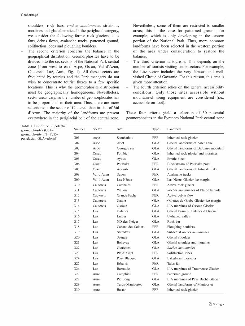
Fig. 2 Example of a potentialperiglacial geomorphosite:active rock glacier of Cambalès(G10). This landform is one ofthe rare active rock glaciers inthe French Pyrenees; 2600 ma.s.l., ph. T Feuillet (08/2007)
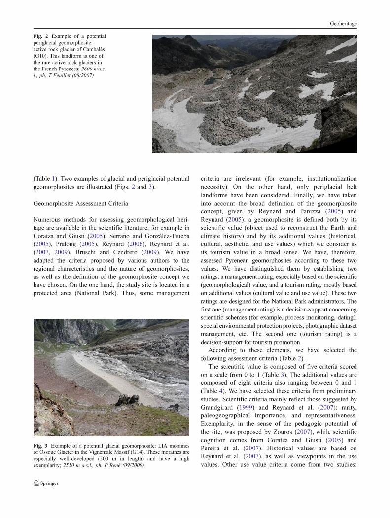
Fig. 3 Example of a potential glacial geomorphosite: LIA morainesof Ossoue Glacier in the Vignemale Massif (G14). These moraines areespecially well-developed (500 m in length) and have a highexemplarity; 2550 m a.s.l., ph. P René (09/2009)
Geoheritage

accessibility and fragility (Serrano and González-Trueba2005); color contrast and integrity (Pralong 2005). Somepotential criteria have been ignored because they are notappropriate to the restricted landform types of the currentstudy, to scale analysis, or to the context of a NationalPark. For example, economic values suggested by Pralong(2005) are not so useful in a National Park. The geo-historical importance suggested by Reynard et al. (2007),related to the role of particular sites in the development ofgeosciences, is also not appropriate here because it doesnot concern any of the potential glacial or periglacialgeomorphosites. Finally, some criteria have been mergedto make the numerical assessment lighter. Thus, sub-criteria“state of conservation” and “impacts” defined by Serrano andGonzález-Trueba (2005) have been merged as “integrity” inthe present study.
Geomorphosite Selection System
We consider that the management rating (MR), which is adecision-support aimed at the Park managers for scientificschemes, is mainly based on the scientific values (SV) andto a lesser extent on the additional values (AV). In contrast,the tourism rating (TR), which is aimed at tourism
promotion, is mainly based on the additional values. Thisdistinction will make the classification of the geomorpho-sites easier, according to the priority of the Park admin-istrators. Thus, these two ratings are calculated in thefollowing way:
MR ¼ SVþ AV=2ð Þ and TR ¼ AVþ SV=2ð Þ with AV
¼ CVþ UV
where SV is the scientific value, AV the additional values,CV the cultural value, and UV the use value. SV and AVscores are weighted out of ten to facilitate comparisons.MR and TR are also scored out of ten.
This scoring is used to establish a classification, whichallows us to define the priority geomorphosites, both interms of management and tourism promotion. For this, onecan plot the geomorphosite assessment results in a referenceframe where each geomorphosite is depicted as a point withMR and TR as its coordinates. We used a particular methodto determine clusters: Hierarchical Ascendant Classification(HAC), or Cluster Analysis, to have maximum objectivity.This hierarchical method consists in combining the obser-vations sequentially, by reducing the number of clusters ateach step, until all individuals belong to one cluster only.
Scientific value Additional values
Use value Cultural value
Rarity at regional and local scale Viewpoints Religious and symbolic importance
Paleogeographical interests Color contrast Historical importance
Representativeness Accessibility Artistic and literary importance
Exemplarity Integrity
Scientific cognition Fragility
Total score
Table 2 Summary of allgeomorphosite assessmentcriteria
Table 3 Numerical assessment of the scientific value
Scientific value
Score 0 0.25 0.5 0.75 1
Rarity More than 7 Between 5 and 7 Between 3 and 4 Between 1 and 2 One of a kind
Corresponding to the number of identical sites in the Pyrenees National Park. Mark is increased if the site is rare at the slope scale.
Paleogeographical interests None Weak Medium High Very high
Depends on the site interests in the morphoclimatic reconstructions and on the possibilities of dating.
Representativeness None Weak Medium High Very high
Depends on the landform representativeness with regard to the producer processes. Landform characteristic or not of the considered processes.
Exemplarity None Weak Medium High Very high
Depends on the intrinsic qualities of the site (size, geometry, aestheticism, readability). Exemplarity is related to the educational potential ofthe site.
Scientific cognition None Weak Medium High Very high
Depends on the number of papers/theses written about the site. Publication impact (local, national, international) has an influence on the score.
Geoheritage
Therefore, it starts with all individuals and leads to theirseparation into smaller groups until there is one object percluster (Almeida et al. 2007). This method was implementedwith the “R” freeware (FactomineR package). The resultinghomogeneous groups could be interpreted visually, thanks tothe plot.
Results
Assessment Results and Classification
All the 30 potential geomorphosites have been assessed andthe results are summarized in Table 7. A specific exampleof an assessment concerning the LIA moraines of thePays Baché Glacier is also shown (G28, Fig. 4 andTables 5 and 6). Figures 5 and 6, created by GIS(Geographical Information System) processing, show thespatial distribution of the 30 sites according to theirmanagement score and tourism score. The eastern part ofthe National Park is most represented, especially theVignemale Massif and the Cirque of Gavarnie. This can
be explained by both the higher elevation (all the peakshigher than 3,000 m a.s.l., except the Balaïtous Massif, arelocated here) which controls glacier occurrence and activeperiglacial features, and better accessibility and tourismfacilities (more roads, refuges, tracks). However, the G04and G07 sites counterbalance this observation.
Figures 5 and 6 and Table 7 reveal a visible correlationbetween management and tourism scores. This is true, forexample, for G01, G02, G13, and G21. Nevertheless, somegeomorphosites seem to have a high management rankingwith a weak tourism ranking (G09, G27) and conversely(G11, G17).
The HAC (Figs. 7 and 8) enables three main groups ofhomogeneous geomorphosites to be distinguished. Cluster1 (low coordinates) is composed of 11 geomorphosites,cluster 2 (medium coordinates) contains 15 and cluster 3(high coordinates) contains 4. These three groups allow usto define 3° of priority for the National Park managementpolicy:
– Low priority: composed of ten geomorphosites charac-terized by weak management and tourism scores: G01,
Table 4 Numerical assessment of the additional values
Additional values
Cultural value
Score 0 0.25 0.5 0.75 1
Religious and symbolicimportance
Unrelated Weakly related Fairly related Highly related Very highly related
Defined by the relation of the site to religion.
Historical importance No vestige Weak traces Numerous traces
Defined by archeological and/or historical vestiges on the site.
Artistic and literaryimportance
No reference Between 1 and 5 Between 6 and 20 Between 21 and 50 More than 50
Defined by literary and iconographic references to the site since 1950.
Use value
Score 0 0.25 0.5 0.75 1
Viewpoints None 1 2 or 3 Between 4 and 6 More than 6
Depends on the number of viewpoints accessible on foot (less than 1 km from the site).
Color contrast Identical colors Differentcolors
Opposed colors
Depends on the color contrast between the site and the nearby environment (lithologic contrast, disparate vegetation, etc.).
Accessibility More than 1 km froma track
Less than 1 km froma track
Close to alocal road
Close to aregional road
Close to a national ortrans-Pyrenean road
Depends on the site distance from tracks and roads. Refuge or car park presence increases the score.
Integrity Destroyed Very damaged Fairlydamaged
Slightlydamaged
Intact
Depends on the degree of site destruction (natural and/or human impacts).
Fragility High Medium Weak
Depends on the site vulnerability factors according to its intrinsic characteristics. The higher the fragility, the more inadvisable is the use.It is a precaution assessment.
Geoheritage
G02, G03, G05, G06, G08, G12, G15, G21, G25, andG30 (Class 1).
– Medium priority: composed of 16 geomorphositescharacterized by medium management and tourismscores: G07, G09, G10, G11, G13, G16, G17,
G18, G19, G22, G23, G24, G26, G27, and G29(Class 2).
– High priority: four geomorphosites that must beconsidered a priority for management and tourism:G04, G14, G20, and G28 (Class 3).
Table 5 Numerical assessment of the scientific value of the G28 geomorphosite
Scientific value
Score 0 0.25 0.5 0.75 1
Rarity X
LIA moraines exist mostly in the current or formerly Pyrenean deglaciated sites (Ossoue, Taillon, Oulettes, Mont Perdu Glaciers, etc.), even at alocal level.
Paleogeographical interests X
Glacier pushed forward the morainic ridges summit in 1856 (historical evidence). The melting of ice phases is well-documented. Thus, all theproglacial zones present a high paleoenvironmental interest.
Representativeness X
Very high representativeness in glacial geomorphology.
Exemplarity X
Very high exemplarity.
Scientific cognition X
Scientific references to the site: Michelier (1887), Eydoux and Maury (1907), Gaurier (1921), Boucau (1922), Barrère (1953), Höllermann (1967,1968), Grove and Gellatly (1995), Grove (2004), González-Trueba et al. (2007), Feuillet and Sellier (2008), Woodward (2009).
Scientific score: 4/5 i.e. 8/10
G28 : LIA moraines of Pays Baché Glacier General data Sector: Aure
Identification code Landform G28GLA Moraines
Coordinates Elevation 42˚47'59'' N - 00˚06'33'' E 2 800 – 2950 m a.s.l.
Site Type Eastern slope of Pic Long Surfacic
Ph. T. Feuillet (07/2006)
Similar geomorphosites : G14, G26.
SV = 8/10 MR = 7/10 AV = 5/10 TR = 6/10 Management ranking = 1/30 Tourism ranking = 3/30
These moraines, located on the eastern slope of Pic Long, date from the LIA maximal advance of the Pays Baché Glacier (1856). The actual glacier has decreased by 93% for the last 150 years. Today it is covered by paraglacial debris. This site is particularly interesting for educational purposes and for well-known deglaciation chronology.
Fig. 4 Descriptive card of theG28 geomorphosite (LIAmoraines). It is first in themanagement ranking and thirdin the tourism ranking
Geoheritage

100
Kilometres
GavarnieGavarnieGavarnieGavarnieGavarnieGavarnieGavarnieGavarnieGavarnie
CauteretsCauteretsCauteretsCauteretsCauteretsCauteretsCauteretsCauteretsCauterets
BalaïtousBalaïtousBalaïtousBalaïtousBalaïtousBalaïtousBalaïtousBalaïtousBalaïtous
Pic LongPic LongPic LongPic LongPic LongPic LongPic LongPic LongPic Long
Pic de NéouviellePic de NéouviellePic de NéouviellePic de NéouviellePic de NéouviellePic de NéouviellePic de NéouviellePic de NéouviellePic de Néouvielle
Pic du Midi Pic du Midi Pic du Midi Pic du Midi Pic du Midi Pic du Midi Pic du Midi Pic du Midi Pic du Midi d'Ossaud'Ossaud'Ossaud'Ossaud'Ossaud'Ossaud'Ossaud'Ossaud'Ossau
Pic du Midi de BigorrePic du Midi de BigorrePic du Midi de BigorrePic du Midi de BigorrePic du Midi de BigorrePic du Midi de BigorrePic du Midi de BigorrePic du Midi de BigorrePic du Midi de Bigorre
VignemaleVignemaleVignemaleVignemaleVignemaleVignemaleVignemaleVignemaleVignemale
Le TaillonLe TaillonLe TaillonLe TaillonLe TaillonLe TaillonLe TaillonLe TaillonLe Taillon
G09G09G09G09G09G09G09G09G09G09
G18G18G18G18G18G18G18G18G18G18
G27G27G27G27G27G27G27G27G27G27
G28G28G28G28G28G28G28G28G28G28
G14G14G14G14G14G14G14G14G14G14
G29G29G29G29G29G29G29G29G29G29
G25G25G25G25G25G25G25G25G25G25
G30G30G30G30G30G30G30G30G30G30
LescunLescunLescunLescunLescunLescunLescunLescunLescun
EtsautEtsautEtsautEtsautEtsautEtsautEtsautEtsautEtsaut
Arrens-MarsousArrens-MarsousArrens-MarsousArrens-MarsousArrens-MarsousArrens-MarsousArrens-MarsousArrens-MarsousArrens-Marsous
Luz-St-SauveurLuz-St-SauveurLuz-St-SauveurLuz-St-SauveurLuz-St-SauveurLuz-St-SauveurLuz-St-SauveurLuz-St-SauveurLuz-St-Sauveur
GèdreGèdreGèdreGèdreGèdreGèdreGèdreGèdreGèdre
GabasGabasGabasGabasGabasGabasGabasGabasGabas
Pic du Midi d'ArrensPic du Midi d'ArrensPic du Midi d'ArrensPic du Midi d'ArrensPic du Midi d'ArrensPic du Midi d'ArrensPic du Midi d'ArrensPic du Midi d'ArrensPic du Midi d'Arrens
Pic du MarboréPic du MarboréPic du MarboréPic du MarboréPic du MarboréPic du MarboréPic du MarboréPic du MarboréPic du Marboré
G20G20G20G20G20G20G20G20G20G20
G19G19G19G19G19G19G19G19G19G19
G15G15G15G15G15G15G15G15G15G15
G26G26G26G26G26G26G26G26G26G26
G22G22G22G22G22G22G22G22G22G22
G17G17G17G17G17G17G17G17G17G17
G16G16G16G16G16G16G16G16G16G16
G13G13G13G13G13G13G13G13G13G13
G12G12G12G12G12G12G12G12G12G12G11G11G11G11G11G11G11G11G11G11
G10G10G10G10G10G10G10G10G10G10
G08G08G08G08G08G08G08G08G08G08
G07G07G07G07G07G07G07G07G07G07
G06G06G06G06G06G06G06G06G06G06
G05G05G05G05G05G05G05G05G05G05
G04G04G04G04G04G04G04G04G04G04G02G02G02G02G02G02G02G02G02G02
G03G03G03G03G03G03G03G03G03G03
G01G01G01G01G01G01G01G01G01G01
G24G24G24G24G24G24G24G24G24G24
G23G23G23G23G23G23G23G23G23G23
Management score
> 5.94
5.15 - 5.94
4.77- 5.15
4.25- 4.77
< 4.25
Pyrénées National Park central zone
Roads
Main refuges
Fig. 5 Geomorphosite distribution according to the management ranking
Additional values
Cultural value
Score 0 0.25 0.5 0.75 1
Religious and symbolic importance X
Unrelated.
Historical importance X
The body of an izard hunter, Maubic, was discovered in July 1868, in the upper part of the morainic ridge.The Maubic nickname was “Pays Baché”, which gave its name to the glacier.
Artistic and literary importance X
No reference.
Use value
Score 0 0.25 0.5 0.75 1
Viewpoints X
Numerous viewpoints, especially from the Campbieil peak.
Color contrast X
Moraines are made up of crystalline elements settled on a substratum made of sedimentary rocks. Morainevisual distinction is, therefore, made easier.
Accessibility X
Close to a track, but about 3 h walk from the car park. No refuge.
Integrity X
Intact.
Fragility X
Weak.
Additional values score: 4/8 i.e. 5/10
Table 6 Numerical assessmentof the additional values (culturaland use values) of the G28geomorphosite
Geoheritage

Note that in cluster 2 (medium priority), G17 (rochesmoutonnées in Gavarnie) can be distinguished from othergeomorphosites of the same cluster because of its very hightourism ranking (5/30) but only a medium managementranking (13/30). Thus, this geomorphosite can be consideredas a high priority in terms of tourism promotion.
Example of Promotion
The high and medium tourism priority geomorphositesshould be the subject of promotion for the PyreneesNational Park visitors by using several approaches. Forexample, Carton et al. (2005) developed a geomorpholog-ical site mapping method pointing out the interest of GISprocessing. A web GIS enables a lot of information to bepresented to people at different scales. Coratza andRegolini-Bissig (2009) recently suggested methods formapping geomorphosites. Promotion also consists inpublishing educational handbooks on geomorphosites. Inthe Pyrenees National Park, as a short-term measure, itwas decided to construct panels close to the site. We showhere an example for G18 (Fig. 9): ploughing boulders ofPouey Aspé (tourism score, 5.5; ranking 6/30). Theselandforms are located at a site well used by hikers (southTaillon Block close to the Cirque of Gavarnie) andpresent, in addition, a very high exemplarity and educationalvalue.
Recently, a few studies have aimed at promoting earthsciences using educational panels (Summermatter 2003;Pralong 2003, 2006). These studies offered several recom-mendations about illustrative and educational approaches.
The panel is accordingly composed of the four mainelements characterizing effective teaching (Summermatter2003): a location map, color photos, diagrams, and text. Tothese, an abstract, a list of references and a Quaternarychronology were added to the basic structure. Texts had tobe understood by the general public. Thus, technicalterminology is avoided and sentences and paragraphs aremade short. Nevertheless, we included boxes with morespecific terminology for more curious visitors. Schematicdiagrams occupy a central place because the educationalpanel is mainly visual. A block diagram is particularlysuitable for this task because of its easy readability. Allthese elements have to be well-balanced for a moreinformative effect (Summermatter 2003). The educationalpanel, recently printed in A0 paper format, will be set up atthree local well-visited sites: the Sarradets refuge andNational Park valley houses (Gavarnie and Luz). Accordingto the observed popularity of this first test, other prioritygeomorphosites will be promoted.
Discussion
Three missions determine the aims and actions of thePyrenees National Park: knowing and preserving thenatural, cultural, and landscape heritages; favoring sustainabledevelopment and a management that preserves naturalheritages; promoting heritages to the general public.
According to these missions, the present study offersmany interesting features. Firstly, it enables the knowledgeof the geomorphological heritage, currently poorly under-
100
Kilometres
GavarnieGavarnieGavarnieGavarnieGavarnieGavarnieGavarnieGavarnieGavarnie
CauteretsCauteretsCauteretsCauteretsCauteretsCauteretsCauteretsCauteretsCauterets
BalaïtousBalaïtousBalaïtousBalaïtousBalaïtousBalaïtousBalaïtousBalaïtousBalaïtous
Pic LongPic LongPic LongPic LongPic LongPic LongPic LongPic LongPic Long
Pic de NéouviellePic de NéouviellePic de NéouviellePic de NéouviellePic de NéouviellePic de NéouviellePic de NéouviellePic de NéouviellePic de Néouvielle
Pic du Midi Pic du Midi Pic du Midi Pic du Midi Pic du Midi Pic du Midi Pic du Midi Pic du Midi Pic du Midi d'Ossaud'Ossaud'Ossaud'Ossaud'Ossaud'Ossaud'Ossaud'Ossaud'Ossau
Pic du Midi de BigorrePic du Midi de BigorrePic du Midi de BigorrePic du Midi de BigorrePic du Midi de BigorrePic du Midi de BigorrePic du Midi de BigorrePic du Midi de BigorrePic du Midi de Bigorre
VignemaleVignemaleVignemaleVignemaleVignemaleVignemaleVignemaleVignemaleVignemale
Le TaillonLe TaillonLe TaillonLe TaillonLe TaillonLe TaillonLe TaillonLe TaillonLe Taillon
G09G09G09G09G09G09G09G09G09G09
G18G18G18G18G18G18G18G18G18G18
G27G27G27G27G27G27G27G27G27G27
G28G28G28G28G28G28G28G28G28G28
G14G14G14G14G14G14G14G14G14G14
G29G29G29G29G29G29G29G29G29G29
G25G25G25G25G25G25G25G25G25G25
G30G30G30G30G30G30G30G30G30G30
LescunLescunLescunLescunLescunLescunLescunLescunLescun
EtsautEtsautEtsautEtsautEtsautEtsautEtsautEtsautEtsaut
Arrens-MarsousArrens-MarsousArrens-MarsousArrens-MarsousArrens-MarsousArrens-MarsousArrens-MarsousArrens-MarsousArrens-Marsous
Luz-St-SauveurLuz-St-SauveurLuz-St-SauveurLuz-St-SauveurLuz-St-SauveurLuz-St-SauveurLuz-St-SauveurLuz-St-SauveurLuz-St-Sauveur
GèdreGèdreGèdreGèdreGèdreGèdreGèdreGèdreGèdre
GabasGabasGabasGabasGabasGabasGabasGabasGabas
Pic du Midi d'ArrensPic du Midi d'ArrensPic du Midi d'ArrensPic du Midi d'ArrensPic du Midi d'ArrensPic du Midi d'ArrensPic du Midi d'ArrensPic du Midi d'ArrensPic du Midi d'Arrens
Pic du MarboréPic du MarboréPic du MarboréPic du MarboréPic du MarboréPic du MarboréPic du MarboréPic du MarboréPic du Marboré
G20G20G20G20G20G20G20G20G20G20
G19G19G19G19G19G19G19G19G19G19
G15G15G15G15G15G15G15G15G15G15
G26G26G26G26G26G26G26G26G26G26
G22G22G22G22G22G22G22G22G22G22
G17G17G17G17G17G17G17G17G17G17
G16G16G16G16G16G16G16G16G16G16
G13G13G13G13G13G13G13G13G13G13
G12G12G12G12G12G12G12G12G12G12G11G11G11G11G11G11G11G11G11G11
G10G10G10G10G10G10G10G10G10G10
G08G08G08G08G08G08G08G08G08G08
G07G07G07G07G07G07G07G07G07G07
G06G06G06G06G06G06G06G06G06G06
G05G05G05G05G05G05G05G05G05G05
G04G04G04G04G04G04G04G04G04G04G02G02G02G02G02G02G02G02G02G02
G03G03G03G03G03G03G03G03G03G03
G01G01G01G01G01G01G01G01G01G01
G24G24G24G24G24G24G24G24G24G24
G23G23G23G23G23G23G23G23G23G23
Tourism score> 5.5
4.96 - 5.5
4.38- 4.96
4.04- 4.38
< 4.04
Pyrénées National Park central zone
Roads
Main refuges
Fig. 6 Geomorphosite distribution according to the tourism ranking
Geoheritage

Dendrogram
Obs
29O
bs9
Obs
23O
bs27
Obs
11O
bs7
Obs
16O
bs10
Obs
26O
bs13
Obs
19O
bs24
Obs
18O
bs17
Obs
20O
bs14
Obs
28O
bs4
Obs
8O
bs3
Obs
25O
bs12
Obs
21O
bs5
Obs
30O
bs2
Obs
1O
bs15
Obs
22O
bs60
5
10
15
20
25
30
35
Dis
sim
ilari
ties
Cluster 3 Cluster 2Cluster 1
Fig. 8 HAC dendrogram showing three homogeneous geomorphositeclusters
G30
G29
G28
G27
G26
G25
G24
G23
G22
G21
G20
G19
G18G17
G16
G15
G14
G13
G12
G11
G10
G09
G08
G07
G06
G05
G04
G03
G02G01
2
2.5
3
3.5
4
4.5
5
5.5
6
6.5
7
2 2.5 3 3.5 4 4.5 5 5.5 6 6.5 7 7.5 8
Cluster 2
Cluster 3
Cluster 1
Management score /10
Tour
ism
sco
re /1
0
Fig. 7 Clustering of the 30 geomorphosites
Number Sector Type Managementscore/10
Tourismscore/10
Management ranking Tourism ranking
G01 Aspe PER 4.35 4.21 21 21
G02 Aspe GLA 4.35 4.21 22 22
G03 Aspe GLA 3.81 3.63 27 28
G04 Ossau GLA 6.90 5.79 2 4
G05 Ossau GLA 4.48 3.96 19 26
G06 Ossau PER 4.00 4.50 26 16
G07 Ossau GLA 4.77 5.04 17 11
G08 Val d’Azun PER 3.35 3.71 28 27
G09 Val d’Azun GLA 5.15 4.29 12 20
G10 Cauterets PER 4.79 4.58 16 15
G11 Cauterets GLA 4.65 5.29 18 7
G12 Cauterets PER 3.17 2.83 30 30
G13 Cauterets GLA 5.56 5.13 9 9
G14 Cauterets GLA 6.88 6.25 3 1
G15 Luz GLA 4.46 4.42 20 17
G16 Luz GLA 4.90 4.79 15 13
G17 Luz GLA 5.08 5.67 13 5
G18 Luz PER 6.00 5.50 5 6
G19 Luz GLA 5.23 4.96 11 12
G20 Luz GLA 6.54 6.08 4 2
G21 Luz GLA 4.25 4.00 24 25
G22 Luz GLA 4.33 4.67 23 14
G23 Luz PER 5.27 4.04 10 23
G24 Luz GLA 5.90 5.29 7 8
G25 Luz PER 3.27 3.04 29 29
G26 Luz GLA 5.79 5.08 8 10
G27 Aure PER 5.94 4.38 6 18
G28 Aure GLA 7.00 6.00 1 3
G29 Aure GLA 4.92 4.33 14 19
G30 Aure PER 4.02 4.04 25 24
4.97 4.66
Table 7 General numericalassessment of the 30 potentialgeomorphosites
Geoheritage

stood, to be improved and organized into a hierarchy.Secondly, the geomorphosite knowledge helps the NationalPark to better define the effects of global warming onperiglacial landscapes. Thus, the National Park will supportcomplementary studies about the altitudinal mobility ofperiglacial features. Thirdly, from a management andpreservation point of view, the integration of a georefer-enced dataset into a GIS enables the geomorphologicalheritage to be spatialized and taken into account in land useprojects or other particular use projects. Finally, tourismpromotion is considered at different levels: on site througheducational panels and on the website through the onlineGIS. Within this, it is intended to create a data layer aboutgeomorphosites so that any internet user can obtaininformation about the Pyrenean geomorphological heritage.A film is also planned, aiming to present the geological andgeomorphological heritage of the Pyrenean landscapes.
Conclusion
Thirty glacial and periglacial geomorphosites were assessed.We used a clustering methodology (factor analysis) to define
homogeneous groups of geomorphosites. This approach,original and repeatable in other areas, ensures an objectiveselection of promoted and used sites. This point is an importantfact because subjectivity is often a problem in geoheritageassessment in general (Bruschi and Cendrero 2005, 2009).The three defined geomorphosite clusters (“High priority”,“Medium priority” and “Low priority”) are used to target thepriority geomorphosites both in terms of management andtourism uses. We propose the promotion of one of thesepriority sites, the ploughing boulders of Gavarnie, by printingan educational panel for the general public.
This Pyrenees National Park geomorphosite assessmentrepresents the first general work on the French Pyreneangeomorphological heritage. It provides effective decision-support for the National Park administrators concerninglandscape management. At the same time, it is a means bywhich numerous tourists may become aware of some of theexceptional landforms in the protected area. In this study,only glacial and periglacial geomorphosites of the PyreneesNational Park were assessed. Clearly, this assessment could beextended to other landform types (structural, gravitational,fluvial, paraglacial, etc.), in order to consider all National Parklandscapes.
Fig. 9 Example of geomorphosite promotion: educational panel on ploughing boulders (G18)
Geoheritage
Acknowledgment The authors wish to thank D. Mercier for hissuggestions, S. Candel for improving the language, as well as E.Reynard and an anonymous reviewer for their corrections.
References
Almeida JAS, Barbosa LMS, Pais AACC, Formosinho SJ (2007)Improving hierarchical cluster analysis: a new method withoutlier detection and automatic clustering. Chemom Intell LabSyst 87:208–217
Barrère P (1953) Équilibre glaciaire actuel et Quaternaire dans l’Ouestdes Pyrénées Centrales. Rev Géogr Pyrén Sud Ouest 24(2):116–134
Boucau H (1922) Les glaciers des Pyrénées occidentales, d’après M.Ludovic Gaurier. Rev Géogr Alp 10(4):635–648
Bruschi VM, Cendrero A (2005) Geosite evaluation; can we measureintangible values? Quaternario 18(1):291–306
Bruschi VM, Cendrero A (2009) Direct and parametric methods forthe assessment of geosites and geomorphosites. In: Reynard E,Coratza P, Regolini-Bissig G (eds) Geomorphosites. Pfeil,München, pp 73–88
Carton A, Coratza P, Marchetti M (2005) Guidelines for geomorpho-logical sites mapping: examples from Italy. Géomorphol ReliefProcessus Environnement 3:209–218
Coratza P, Giusti C (2005) Methodological proposal for theassessment of the scientific quality of geomorphosites. Quater-nario 18(1):307–313
Coratza P, Regolini-Bissig G (2009) Methods for mapping geo-morphosites. In: Reynard E, Coratza P, Regolini-Bissig G (eds)Geomorphosites. Pfeil, München, pp 89–103
De Waele J, Melis MT (2008) Geomorphology and geomorphologicalheritage of the Ifrane-Azrou region (Middle Atlas, Morocco).Environ Geol 55:587–599
Eydoux D, Maury L (1907) Les glaciers orientaux du Pic Long(Pyrénées centrales). Géogr 16(1):1–18
Feuillet T, Portal C (2008) Les glaciers rocheux des Pyrénéescentrales: un patrimoine naturel à découvrir. Pyrén 235:267–280
Feuillet T, Sellier D (2008) Observations sur la limite inférieure del’étage périglaciaire dans les Pyrénées centrales françaises(Bigorre). Environ Périglac 15:59–68
Gaurier L (1921) Etudes glaciaires dans les Pyrénées françaises etespagnoles de 1900 à 1909. Garet-Haristoy, Pau, 363 pp
Grandgirard V (1999) L’évaluation des géotopes. Geol Insubrica4:59–66
González-Trueba JJ, Martín Moreno R, Serrano E (2007) Elglaciarismo de la Pequeña Edad del Hielo en las MontañasIbéricas. Síntesis y estado actual de conocimiento. Rev CG 21(1–2):57–86
Grove JM (2004) Little ice ages. Routledge, London, 718 ppGrove JM, Gellatly AF (1995) Little ice age glacier fluctuations in the
Pyrénées. Z Gletsch Glazialgeol 31:199
Höllermann PW (1967) Zur Verbreitung rezenter periglazialerKleinformen in den Pyrenäen und Ostalpen. Gött Geogr Abh(40):198 pp
Höllermann PW (1968) Die rezenten Gletscher der Pyrenäen. GeogrHelv 23(4):157–168
Michelier M (1887) Etude sur les variations des glaciers des Pyrénées.Ann Bur Cent Météorol Fr
Paris Panizza M (2001) Geomorphosites: concepts, methods andexamples of geomorphological survey. Chin Sci Bull 46:4–6
Pereira P, Pereira D, Caetano Alves M (2007) Geomorphositeassessment in Montesinho Natural Park (Portugal). Geogr Helv62(3):159–168
Pralong JP (2003) Valorisation et vulgarisation des sciences de laTerre: les concepts de temps et d’espace et leur application à larandonnée pédestre In: Reynard E, Holzmann C, Guex D,Summermatter N (eds) Géomorphologie et Tourisme, Institut degéographie, Université de Lausanne, Travaux et Recherches24 pp 115–127 (available on-line: http://mesoscaphe.unil.ch/Site-IGUL-Jahia/travaux_recherches.php)
Pralong JP (2005) A method for assessing tourist potential and use ofgeomorphological sites. Géomorphol Relief Processus Environ-nement 3:189–196
Pralong JP (2006) Géotourisme et utilisation de sites naturels d’intérêtpour les sciences de la Terre. PhD Thesis, University of Lausanne(available on-line http://mesoscaphe.unil.ch/Site-IGUL-Jahia/travaux_recherches.php)
Reynard E (2005) Géomorphosites et paysages. Géomorphol ReliefProcessus Environnement 3:181–188
Reynard E (2006) Fiche d’inventaire des géomorphosites. -http://www.unil.ch/igul/page17893.html
Reynard E, Panizza M (2005) Geomorphosites: definition, assessmentand mapping. An introduction. Géomorphol Relief ProcessusEnvironnement 3:177–180
Reynard E, Fontana G, Kozlik L, Scapozza C (2007) A method forassessing «scientific» and «additional values» of geomorphosites.Geogr Helv 62(3):148–158
Reynard E, Coratza P, Regolini-Bissig G (2009) Geomorphosites.Pfeil, München, 240 pp
Serrano E, González-Trueba JJ (2005) Assessment of geomorphositesin natural protected areas: the Picos de Europa National Park(Spain). Géomorphol Relief Processus Environnement 3:197–208
Summermatter N (2003) Quelques réflexions sur les techniquesscripto-illustratives utilisées dans les brochures relatives auxitineraries didactiques In: Reynard E, Holzmann C, Guex D,Summermatter N (eds) Géomorphologie et Tourisme, Institut degéographie, Université de Lausanne, Travaux et Recherches24 pp 129–144 (available on-line: http://mesoscaphe.unil.ch/Site-IGUL-Jahia/travaux_recherches.php)
Woodward J (2009) The physical geography of the Mediterranean.Oxford University Press, Oxford, 663 pp
Zouros N (2007) Geomorphosite assessment and management inprotected areas of Greece. The case of the Lesvos island coastalgeomorphosites. Geogr Helv 62(3):169–180
Geoheritage