geomorphic analysis of the luckiamute watershed, central coast range, oregon: integrating applied...
TRANSCRIPT
GEOMORPHIC ANALYSIS OF THE LUCKIAMUTE WATERSHED, CENTRAL COAST RANGE, OREGON:
INTEGRATING APPLIED WATERSHED SCIENCE WITH UNDERGRADUATE RESEARCH AND COMMUNITY OUTREACH
Steve TaylorEarth and Physical Sciences Department
Western Oregon UniversityMonmouth, Oregon 97361
• Introduction
Watersheds as Undergraduate Service Learning Laboratories
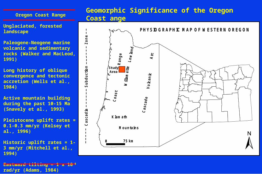
Geomorphic Significance of the central Oregon Coast Range
• Luckiamute River Study Area
• Results of Geomorphic Analyses
• Summary and Conclusion

INTRODUCTION
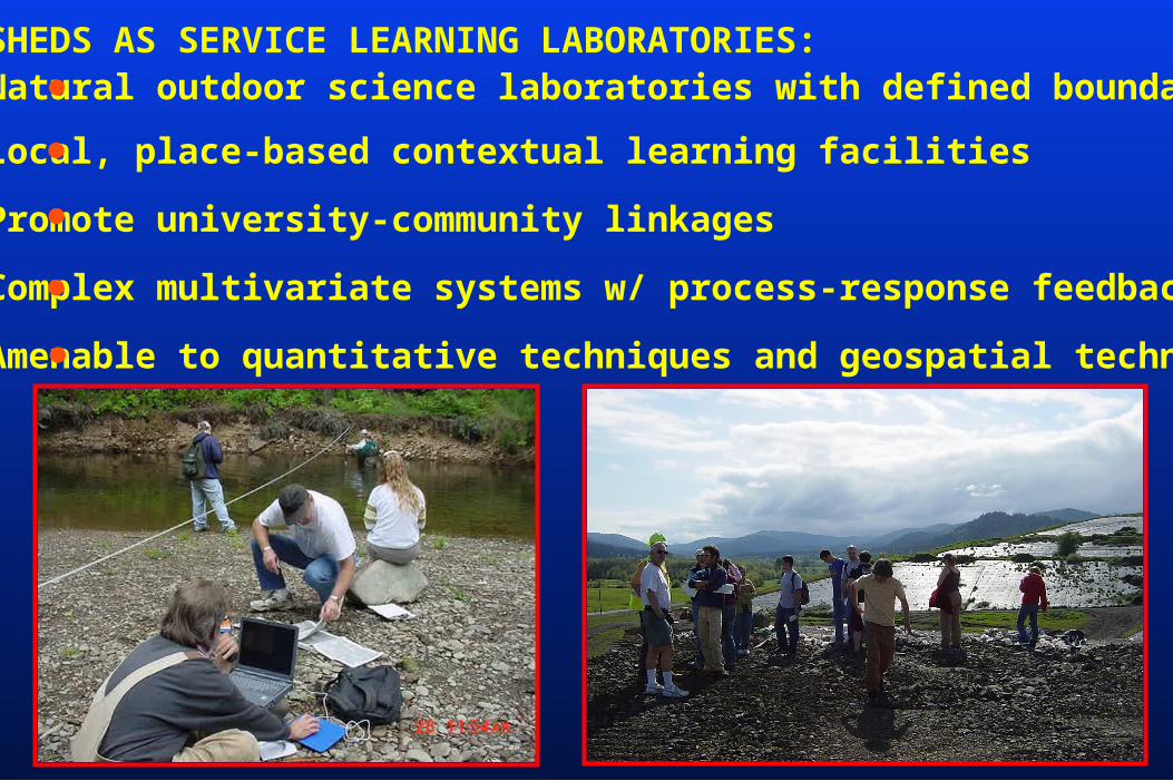
WATERSHEDS AS SERVICE LEARNING LABORATORIES: Natural outdoor science laboratories with defined boundaries
Local, place-based contextual learning facilities
Promote university-community linkages
Complex multivariate systems w/ process-response feedbacks
Amenable to quantitative techniques and geospatial technology
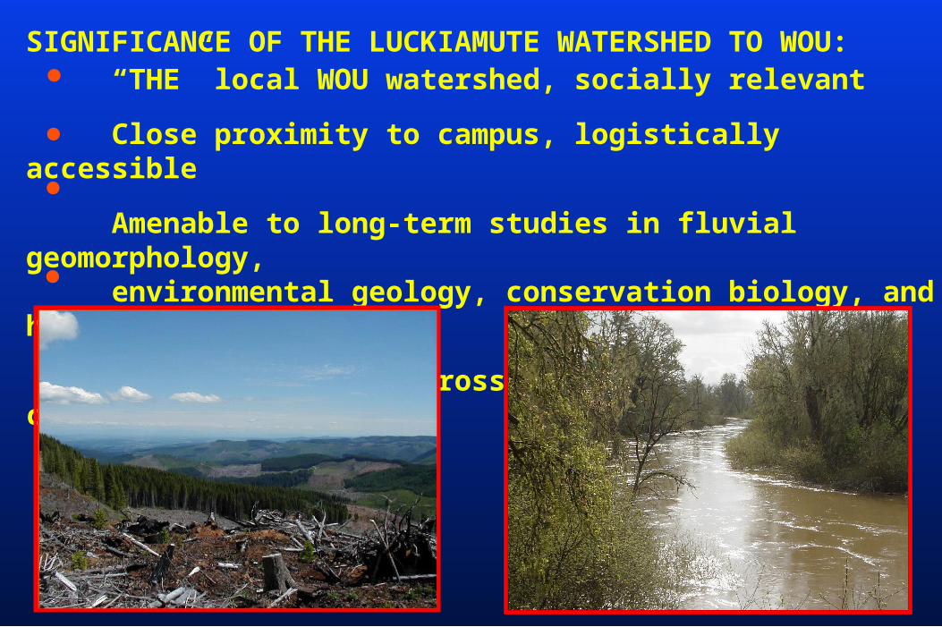
SIGNIFICANCE OF THE LUCKIAMUTE WATERSHED TO WOU: “THE” local WOU watershed, socially relevant
Close proximity to campus, logistically accessible
Amenable to long-term studies in fluvial geomorphology, environmental geology, conservation biology, and hydrology
Opportunities for cross-collaboration and community outreach
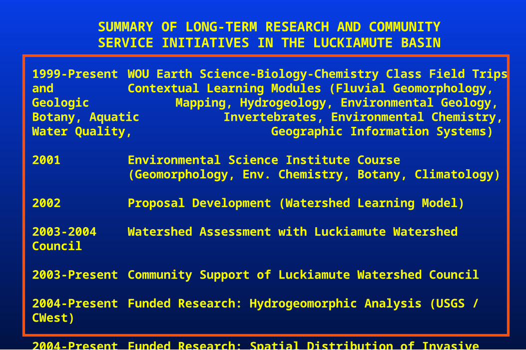
1999-Present WOU Earth Science-Biology-Chemistry Class Field Trips and Contextual Learning Modules (Fluvial Geomorphology, Geologic Mapping, Hydrogeology, Environmental Geology, Botany, Aquatic Invertebrates, Environmental Chemistry, Water Quality, Geographic Information Systems)
2001 Environmental Science Institute Course(Geomorphology, Env. Chemistry, Botany, Climatology)
2002 Proposal Development (Watershed Learning Model)
2003-2004 Watershed Assessment with Luckiamute Watershed Council
2003-Present Community Support of Luckiamute Watershed Council
2004-Present Funded Research: Hydrogeomorphic Analysis (USGS / CWest)
2004-Present Funded Research: Spatial Distribution of Invasive Plants (OCF)
SUMMARY OF LONG-TERM RESEARCH AND COMMUNITYSERVICE INITIATIVES IN THE LUCKIAMUTE BASIN
Will
amet
te
Cas
cad
e
Ran
ge
K lamath
MountainsL
ow
lan
d
Co
ast
Vo
lcan
icA
rc
Ca
sc
ad
ia
Su
bd
uc
tio
n
Zo
ne
0 75 km
PHYSIOGRAPHIC MAP OF W ESTERN OREGON
Oregon Coast Range
Unglaciated, forested landscape
Paleogene-Neogene marine volcanic and sedimentary rocks (Walker and MacLeod, 1991)
Long history of oblique convergence and tectonic accretion (Wells et al., 1984)
Active mountain building during the past 10-15 Ma (Snavely et al., 1993)
Pleistocene uplift rates = 0.1-0.3 mm/yr (Kelsey et al., 1996)
Historic uplift rates = 1-3 mm/yr (Mitchell et al., 1994)
Eastward tilting = 1 x 10⁻⁸ rad/yr (Adams, 1984)
Holocene erosion rates = 0.05-0.33 mm/yr (Roering et al., 2005)
Geomorphic Significance of the Oregon Coast ange
StudyArea
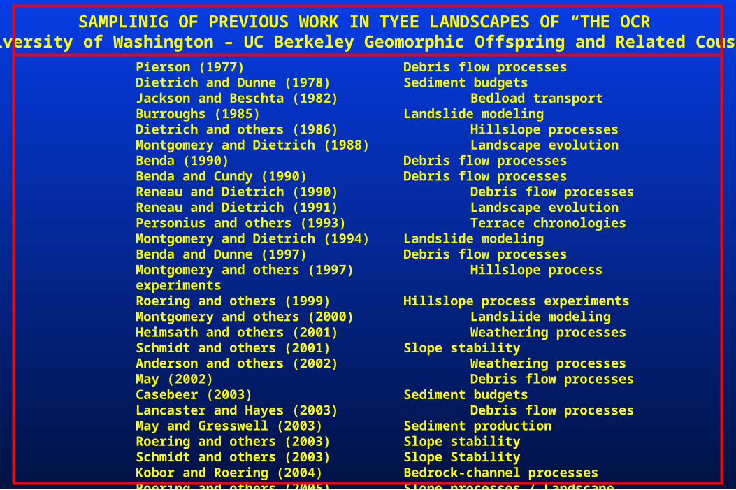
Pierson (1977) Debris flow processesDietrich and Dunne (1978) Sediment budgetsJackson and Beschta (1982) Bedload transportBurroughs (1985) Landslide modelingDietrich and others (1986) Hillslope processesMontgomery and Dietrich (1988) Landscape evolutionBenda (1990) Debris flow processesBenda and Cundy (1990) Debris flow processesReneau and Dietrich (1990) Debris flow processesReneau and Dietrich (1991) Landscape evolutionPersonius and others (1993) Terrace chronologiesMontgomery and Dietrich (1994) Landslide modelingBenda and Dunne (1997) Debris flow processesMontgomery and others (1997) Hillslope process experimentsRoering and others (1999) Hillslope process experimentsMontgomery and others (2000) Landslide modelingHeimsath and others (2001) Weathering processesSchmidt and others (2001) Slope stabilityAnderson and others (2002) Weathering processesMay (2002) Debris flow processesCasebeer (2003) Sediment budgetsLancaster and Hayes (2003) Debris flow processesMay and Gresswell (2003) Sediment productionRoering and others (2003) Slope stabilitySchmidt and others (2003) Slope StabilityKobor and Roering (2004) Bedrock-channel processesRoering and others (2005) Slope processes / Landscape Evolution
SAMPLINIG OF PREVIOUS WORK IN TYEE LANDSCAPES OF “THE OCR”University of Washington – UC Berkeley Geomorphic Offspring and Related Cousins
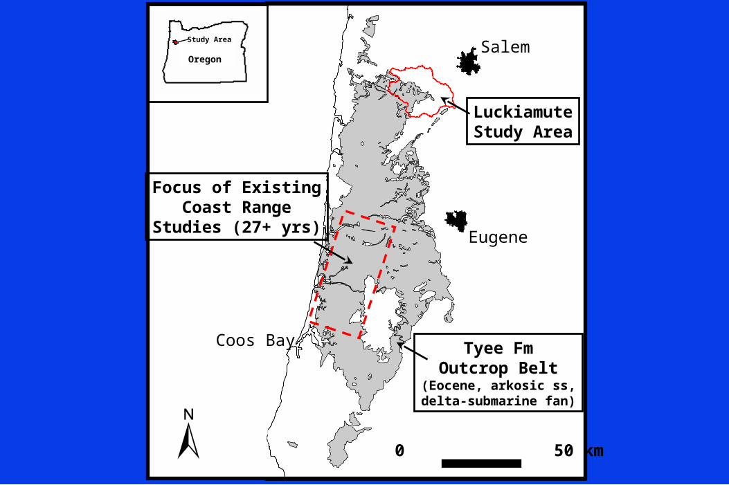
Salem
LuckiamuteStudy Area
Eugene
Tyee FmOutcrop Belt
(Eocene, arkosic ss,delta-submarine fan)
0 50 km
Focus of ExistingCoast Range
Studies (27+ yrs)
Coos Bay
Study Area
Oregon
LUCKIAMUTE RIVERSTUDY AREA
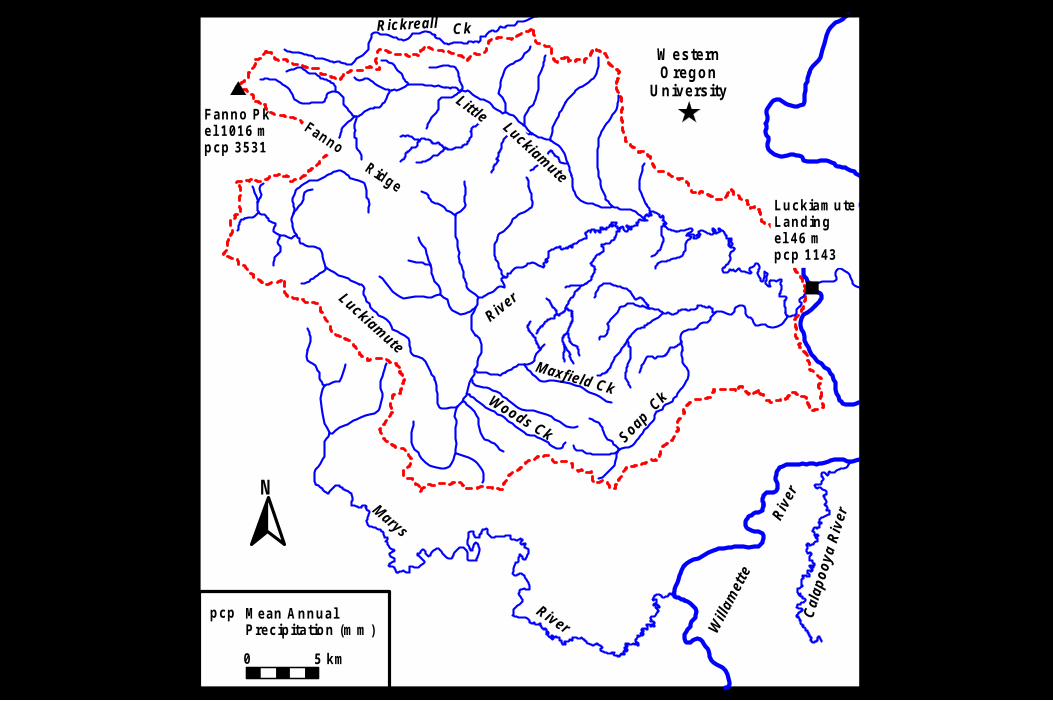
River
Soap Ck
River
Rickreall
Will
amet
te
Cal
apo
oya
Riv
er
Fanno Pkel 1016 mpcp 3531
Maxfield CkWoods Ck
Luckiamute
Riv
er
Marys
Ck
N
LuckiamuteLandingel 46 mpcp 1143
Luckiamute
LittleFanno Ridge
0 5 km
W esternOregon
University
Mean AnnualPrecipitation (mm)
pcp
Tsr Tsr
Tt
Tt
Tt
Tsr
Ty
T y
T y
T y
T y
T y T y
Tsr
T y
T y
T s s
T s s
T s s
T s s
H a l
Q a l
Q a l
Q a l
Qal
N
T y
0 5 km
Tss
Ty
Tt
I I I
I V
I
I I
Holocene alluviumQ uaternary a lluviumO ligocene intrusiveYam hill Form ationSpencer Form ationTyee Form ationS iletz R iver Volcanics
HalQal
TyTssTtTsr
Fault
0 5 km
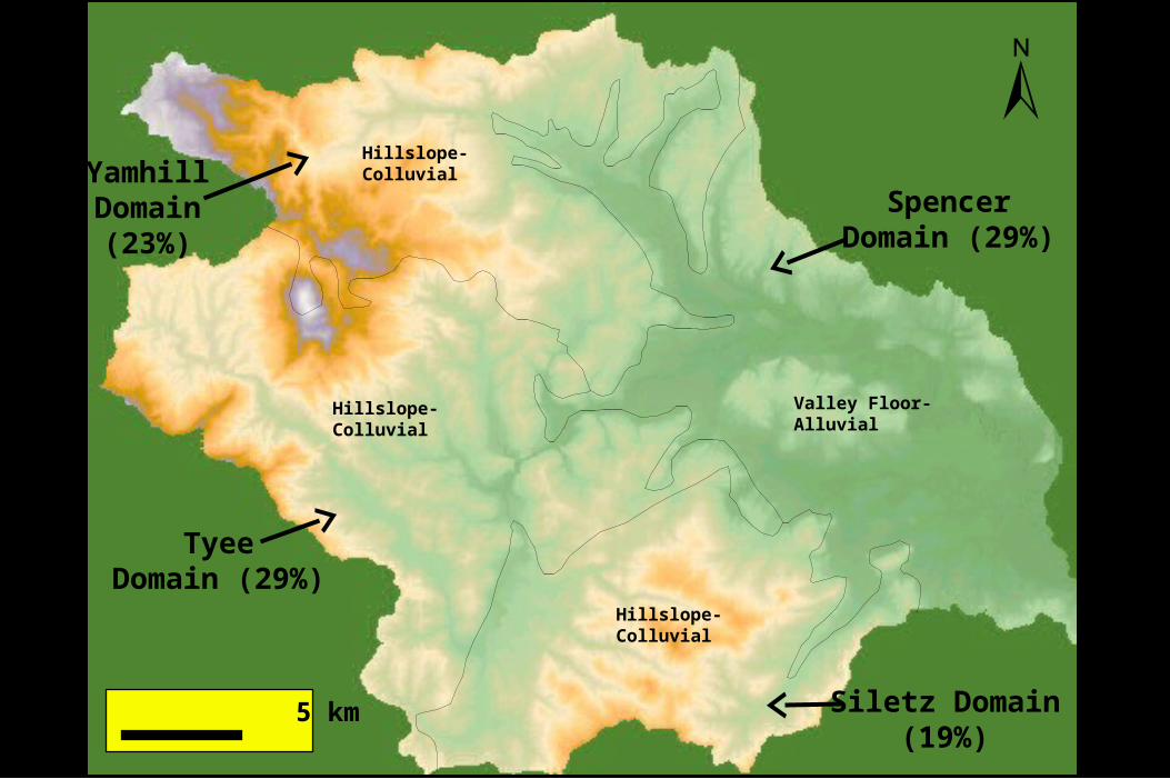
TyeeDomain (29%)
Siletz Domain (19%)
SpencerDomain (29%)
YamhillDomain(23%)
Hillslope-Colluvial
Hillslope-Colluvial
Hillslope-Colluvial
Valley Floor-Alluvial
0 100002000030000400005000060000700008000090000100000
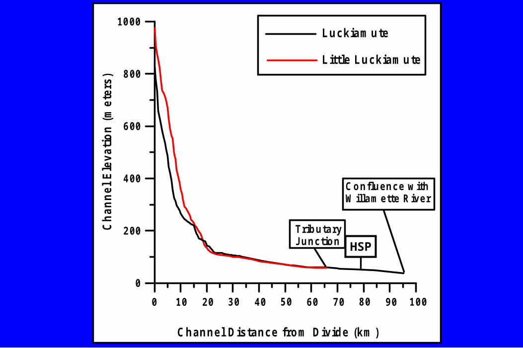
Channel Distance from Divide (km )
0
200
400
600
800
1000
Ch
ann
el E
leva
tio
n (
met
ers)
0 20000 40000 60000 80000 100000
Luckiamute
Little Luckiamute
TributaryJunction
Confluence withWillamette River
0 10 20 30 40 50 60 70 80 90 100
HSP
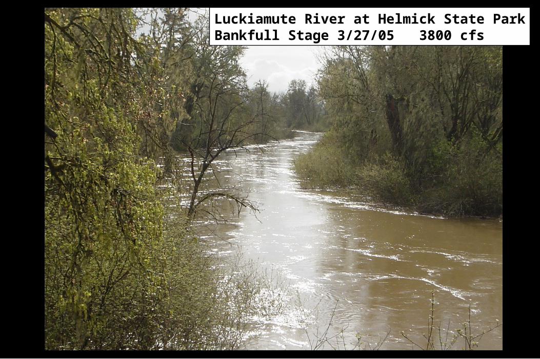
Luckiamute River at Helmick State ParkBankfull Stage 3/27/05 3800 cfs
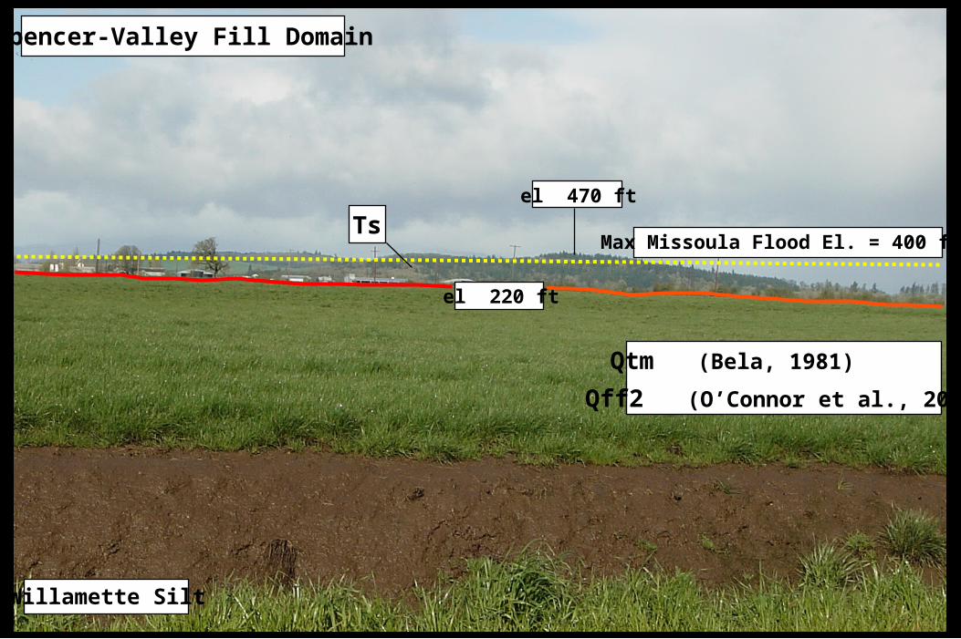
Willamette Silt
el 470 ft
el 220 ft
Qtm (Bela, 1981)
Qff2 (O’Connor et al., 2001)
Max Missoula Flood El. = 400 ft)Ts
Spencer-Valley Fill Domain
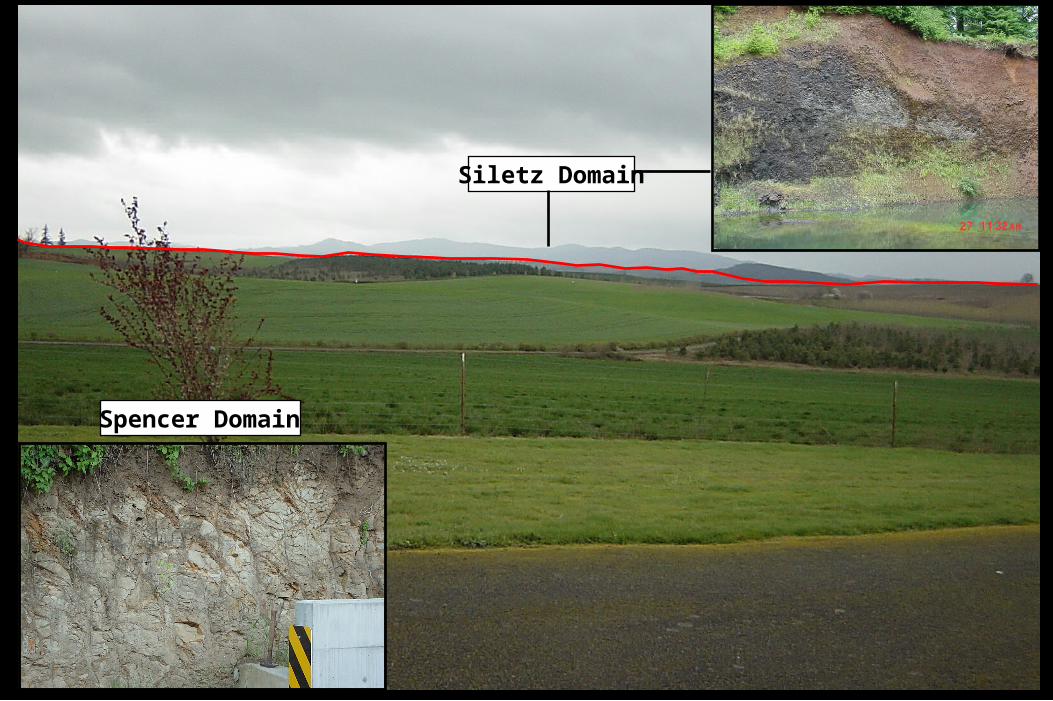
Siletz Domain
Spencer Domain
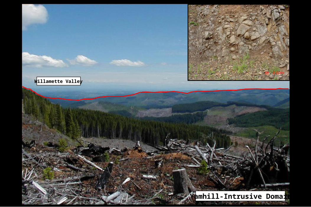
Yamhill-Intrusive Domain
Willamette Valley
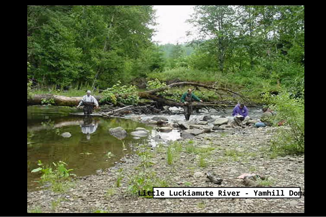
Little Luckiamute River - Yamhill Domain
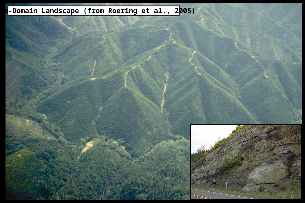
Tyee-Domain Landscape (from Roering et al., 2005)
MORPHOMETRIC ANALYSES
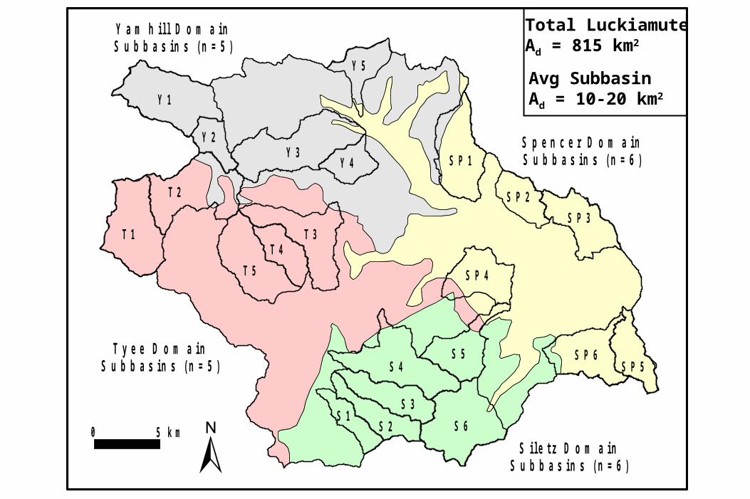
S p e n c e r D o m a i nS u b b a s i n s ( n = 6 )
S i l e t z D o m a i nS u b b a s i n s ( n = 6 )
T y e e D o m a i nS u b b a s i n s ( n = 5 )
Y a m h i l l D o m a i nS u b b a s i n s ( n = 5 )
0 5 k m S 6
S 5S 4
S 3
S 2S 1
T 1
T 2
T 3T 4
T 5
Y 1
Y 2Y 3
Y 4
Y 5
S P 1
S P 2
S P 3
S P 4
S P 5S P 6
Total LuckiamuteAd = 815 km2
Avg SubbasinAd = 10-20 km2
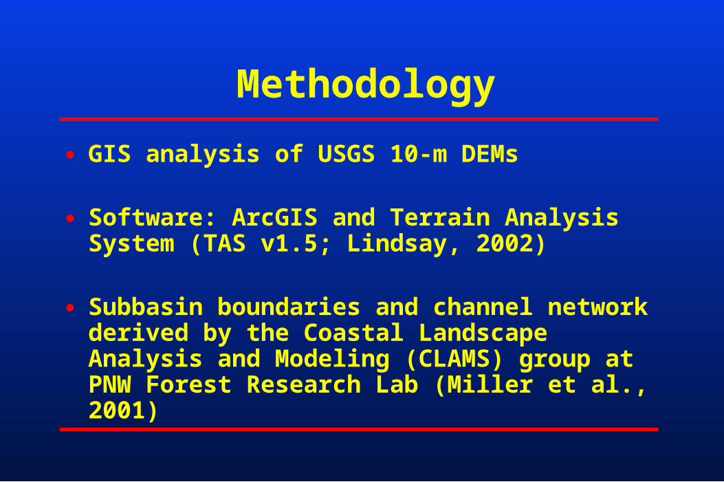
Methodology
● GIS analysis of USGS 10-m DEMs
● Software: ArcGIS and Terrain Analysis System (TAS v1.5; Lindsay, 2002)
● Subbasin boundaries and channel network derived by the Coastal Landscape Analysis and Modeling (CLAMS) group at PNW Forest Research Lab (Miller et al., 2001)
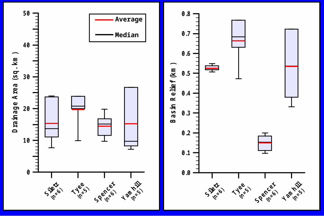
0
10
20
30
40
50D
rain
age
Are
a (s
q.
km)
Siletz
Tyee
Spencer
Yamhill
(n=6)
(n=6)
(n=5)
(n=5)
0.0
0.1
0.2
0.3
0.4
0.5
0.6
0.7
0.8
Bas
in R
elie
f (k
m)
Siletz
Tyee
Spencer
Yamhill
(n=6)
(n=6)
(n=5)
(n=5)
Average
Median
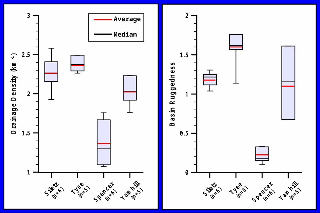
1
1.5
2
2.5
3D
rain
age
De
nsi
ty (
km-1
)
Siletz
Tyee
Spencer
Yamhill
(n=6)
(n=6)
(n=5)
(n=5)
0
0.5
1
1.5
2
Bas
in R
ug
ged
nes
s
Siletz
Tyee
Spencer
Yamhill
(n=6)
(n=6)
(n=5)
(n=5)
Average
Median
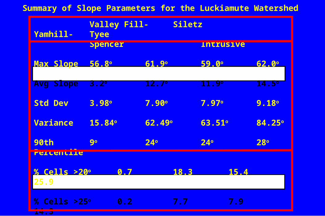
Valley Fill- Siletz Yamhill- TyeeSpencer Intrusive
Max Slope 56.8o 61.9o 59.0o 62.0o
Avg Slope 3.2o 12.7o 11.9o 14.5o
Std Dev 3.98o 7.90o 7.97o 9.18o
Variance 15.84o 62.49o 63.51o 84.25o
90th 9o 24o 24o 28o
Percentile
% Cells >20o 0.7 18.3 15.4 25.9
% Cells >25o 0.2 7.7 7.9 14.3
No. Cells 2290702 1510287 1926899 2409140
Summary of Slope Parameters for the Luckiamute Watershed
0.0
0.2
0.4
0.6
0.8
1.0
1.2
Rel
ativ
e S
trea
m P
ow
er I
nd
ex
Siletz
Tyee
Spencer
Yamhill
(n=6)
(n=6)
(n=5)
(n=5)
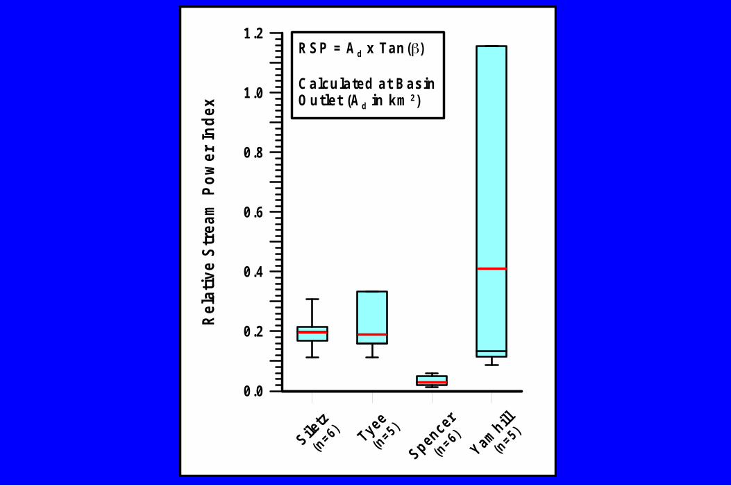
RSP = A d x Tan()
Calculated at BasinOutlet (A d in km 2)
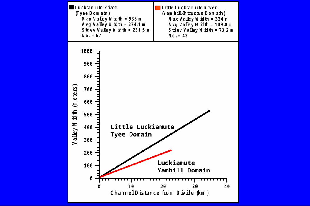
Channel Distance from Divide (km )
0
100
200
300
400
500
600
700
800
900
1000
Val
ley
Wid
th (
met
ers)
0 10 20 30 40
Luckiamute River(Tyee Domain) Max Valley W idth = 938 m Avg Valley W idth = 274.1 m Stdev Valley W idth = 231.5 m No. = 67
Little Luckiamute River(Yamhill-Intrusive Domain) Max Valley W idth = 334 m Avg Valley W idth = 109.0 m Stdev Valley W idth = 73.2 m No. = 43
LuckiamuteYamhill Domain
Little LuckiamuteTyee Domain

SUMMARY AND CONCLUSION
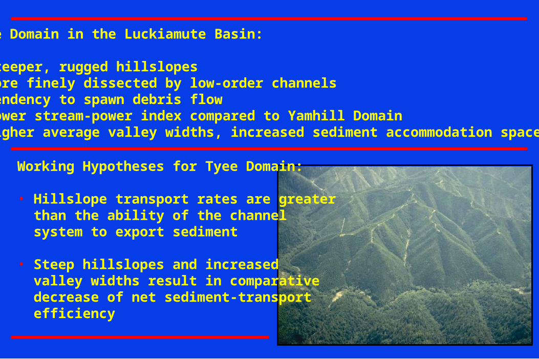
Tyee Domain in the Luckiamute Basin:
• Steeper, rugged hillslopes• More finely dissected by low-order channels• Tendency to spawn debris flow• Lower stream-power index compared to Yamhill Domain• Higher average valley widths, increased sediment accommodation space
Working Hypotheses for Tyee Domain:
• Hillslope transport rates are greater than the ability of the channel system to export sediment
• Steep hillslopes and increased valley widths result in comparative decrease of net sediment-transport efficiency
The Luckiamute Watershed represents a model outdoor laboratory for contextual and service learning opportunities in the Natural Sciences at Western Oregon University
Geomorphic analysis suggests that spatial variation of bedrock lithology is a primary factor controlling slope gradients, hillslope delivery rates, and resulting sediment-transport efficiency of the channel system.
The Luckiamute Watershed is uniquely positioned at the northern terminus of the Tyee outcrop belt, thus providing an opportunity for comparative geomorphic analysis.
The rich body of work from other Tyee landscapes in the OCR will serve as the platform from which to extend future research into other bedrock domains.
(1)
(2)
(3)
Concluding Statements
(4)

ACKNOWLEDGMENTS
Funding Sources:OSU Institute for Water and Watersheds (IWW)USGS Water Resources Small-Grants ProgramOregon Community FoundationWestern Oregon University Faculty Development Fund
WOU Student Research Assistants:Diane Hale, Jeff Budnick, Jamie Fisher, Chandra Drury,Katie Knoll, Rachel Pirot, Jeff Kent
WOU Faculty Colleagues2001 Environmental Science Institute: Bryan Dutton (Biology),
Pete Poston (Chemistry), Jeff Myers (Earth Science), Adele Schepige (Education)
Ongoing Research Collaboration: Bryan Dutton (Biology)