mcquesten brook geomorphic assessment and watershed
TRANSCRIPT

M cQuesten Brook Geomorphic Assessment and Watershed
Restoration Plan
Final Repor t October 1, 2013
Prepared for : New H ampshire Rivers Council
54-207 Por tsmouth Street Concord, NH 03301
Prepared by: Comprehensive Environmental I nc.
with H eadwaters H ydrology, FB Environmental Associates, I nc. and
Field Geology Services
With Funding by: New H ampshire Depar tment of
Environmental Services, New H ampshire Fish and Game Depar tment,
New H ampshire Rivers Council, and Samuel P. H unt Foundation

M cQuesten Brook Geomorphic Assessment and Watershed
Restoration Plan
Prepared by Comprehensive Environmental I nc. in cooperat ion with Headwaters Hydrology, the New Hampshire Rivers Counci l , the New Hampshire Depar tment of Environmental Services,
the New Hampshire Fish and Game Department , The City of Manchester , the Town of Bedford, FB Environmental Associates, I nc.,
and Field Geology Services
Final Repor t October 1, 2013
Funding for this project was provided in part by a Watershed Assistance Grant from the New Hampshire Depar tment of Environmental Services with Clean Water Act Sect ion 319 funds from the U.S. Environmental Protect ion Agency

Acknowledments Par tners and Suppor ters New Hampshire Rivers Counci l New Hampshire Department of Environmental Services New Hampshire Fish and Game Department
City of Manchester Town of Bedford River Network Anheuser -Busch Samuel P. Hunt Foundat ion Manchester Flyfishing Associat ion Trout Unl imited Merr imack Valley Chapter Universi ty of New Hampshire
Volunteers – clean up events and serving on M cTeam Steer ing Committee
New Hampshire Rivers Counci l members I ndividuals from Anheuser-Busch City of Manchester Urban Ponds Restorat ion Program City of Manchester Conservat ion Commission City of Manchester Department of Publ ic Works Town of Bedford Conservat ion Commission Town of Bedford Department of Public Works Trout Unl imited Merr imack Valley Chapter Ducks Unl imited Manchester Flyfishing Associat ion New Hampshire Department of Environmental Services New Hampshire Fish and Game Department McQuesten Watershed Residents and Businesses
Consulting Services Comprehensive Environmental I nc. Headwaters Hydrology FB Environmental Associates, I nc.
Field Geology Services Funding Provided By New Hampshire Department of Environmental Services
New Hampshire Fish and Game Department New Hampshire Rivers Counci l Samuel P. Hunt Foundat ion
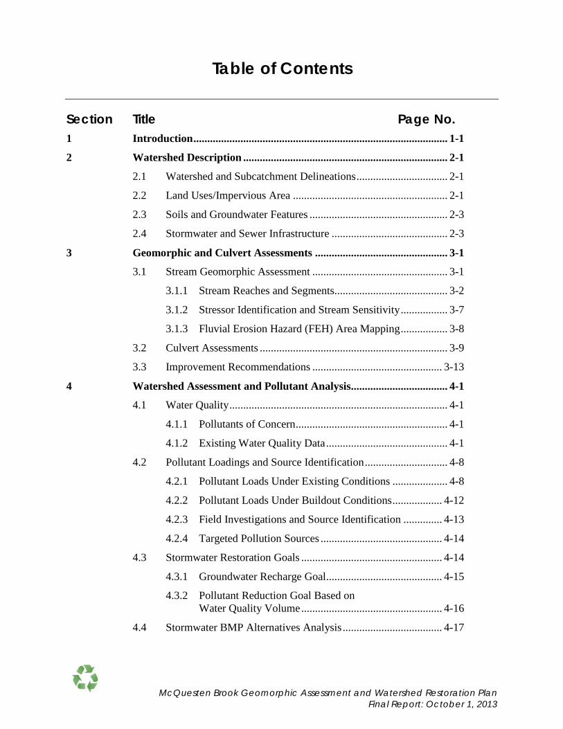
Table of Contents
Section Title Page No.
1 Introduction ............................................................................................ 1-1
2 Watershed Description .......................................................................... 2-1
2.1 Watershed and Subcatchment Delineations ................................. 2-1
2.2 Land Uses/Impervious Area ........................................................ 2-1
2.3 Soils and Groundwater Features .................................................. 2-3
2.4 Stormwater and Sewer Infrastructure .......................................... 2-3
3 Geomorphic and Culvert Assessments ................................................ 3-1
3.1 Stream Geomorphic Assessment ................................................. 3-1
3.1.1 Stream Reaches and Segments......................................... 3-2
3.1.2 Stressor Identification and Stream Sensitivity ................. 3-7
3.1.3 Fluvial Erosion Hazard (FEH) Area Mapping ................. 3-8
3.2 Culvert Assessments .................................................................... 3-9
3.3 Improvement Recommendations ............................................... 3-13
4 Watershed Assessment and Pollutant Analysis ................................... 4-1
4.1 Water Quality ............................................................................... 4-1
4.1.1 Pollutants of Concern ....................................................... 4-1
4.1.2 Existing Water Quality Data ............................................ 4-1
4.2 Pollutant Loadings and Source Identification .............................. 4-8
4.2.1 Pollutant Loads Under Existing Conditions .................... 4-8
4.2.2 Pollutant Loads Under Buildout Conditions .................. 4-12
4.2.3 Field Investigations and Source Identification .............. 4-13
4.2.4 Targeted Pollution Sources ............................................ 4-14
4.3 Stormwater Restoration Goals ................................................... 4-14
4.3.1 Groundwater Recharge Goal .......................................... 4-15
4.3.2 Pollutant Reduction Goal Based on Water Quality Volume ................................................... 4-16
4.4 Stormwater BMP Alternatives Analysis .................................... 4-17
McQuesten Brook Geomorphic Assessment and Watershed Restoration Plan Final Report: October 1, 2013

Table of Contents
5 Recommendations ............................................................................... ...5-1
5.1 Introduction .................................................................................. 5-1
5.2 Recommendations ........................................................................ 5-1
5.3 Overall Plan Success Indicators ................................................. 5-25
List of Figures
Fig. No Title Page No. 1-1 Site Locus Map ...................................................................... End of Section
2-1 Topographic Contours ........................................................... End of Section
2-2 Land Use Characteristics ....................................................... End of Section
2-3 Aerial Photo and Drainage Features ...................................... End of Section
2-4 Soil Characteristics ................................................................ End of Section
2-5 Parcel Boundaries and Sewer System Features ..................... End of Section
3-1 McQuesten Brook Geomorphic Assessment Reach ................................ 3-1
3-2 Phase 1 Reaches ....................................................................................... 3-2
3-3 Phase 2 Segments ..................................................................................... 3-3
3-4 FEH Rating Map ...................................................................................... 3-9
3-5 Culvert Location, Rankings, and Replacement Priorities ...................... 3-12
3-6 Locations of Priority Restoration Recommendations ............................ 3-15
4-1 Monitoring Locations............................................................. End of Section
4-2 DO and Temperature Results at Station 02-MQB ................................... 4-2
4-3 DO and Temperature Results at Station 05-MQB ................................... 4-2
4-4 Specific Conductance Results at Station 02-MQB .................................. 4-4
4-5 Specific Conductance Results at Station 05-MQB .................................. 4-5
4-6 Maximum Daily Air and Water Temperatures
Below South Main Street ......................................................................... 4-6
4-7 Maximum Daily Air and Water Temperatures Below Second Street...... 4-6
McQuesten Brook Geomorphic Assessment and Watershed Restoration Plan Final Report: October 1, 2013

Table of Contents
4-8 Maximum Daily Air and Water Temperatures Below Wathen Road ...... 4-7
4-9 Phosphorus Loads by Subwatershed ........................................................ 4-9
4-10 Per Acre Phosphorus Loads by Subwatershed ....................................... 4-10
4-11 Sediment Load by Subwatershed ........................................................... 4-10
4-12 Per Acre Sediment Load by Subwatershed ............................................ 4-11
4-13 Phosphorus Load by Land Use .............................................................. 4-11
4-14 Sediment Load by Land Use .................................................................. 4-12
4-15 BMP Alternatives................................................................... End of Section
5-1 Wet Pond with Gravel Outlet ................................................................. 5-11
List of Tables
Table No Title Page No. 2-1 McQuesten Brook Watershed Land Use Area ......................................... 2-2
3-1 Geomorphic and Habitat Condition of Stream Segments ........................ 3-3
3-2 Stream Geomorphic Condition and Sensitivity Ratings .......................... 3-8
3-3 Descriptions of Culvert Geomorphic Compatibility Rankings .............. 3-10
3-4 Descriptions of Culvert AOP Rankings ................................................. 3-11
3-5 Culvert Geomorphic Compatibility and AOP Rankings ....................... 3-11
3-6 Prioritized List of Restoration Recommendations ................................. 3-14
4-1 Phosphorus Load by Subwatershed ......................................................... 4-9
4-2 Recharge Factors Based on Hydrologic Soil Group (HSG) .................. 4-15
4-3 Recharge Goals Per Subwatershed ........................................................ 4-16
4-4 WQV Goals Per Subwatershed .............................................................. 4-17
4-5 Best Management Practice (BMP) Alternatives and Applicability ....... 4-19
4-6 BMP Alternatives with Associated Pollutant Load Reductions Recharge and Costs ................................................................................ 4-20
4-7 Comparison of BMP Recharge to Recharge Goal for Sub-1- 11........... 4-21
5-1 McQuesten Brook Capital Improvement Plan & Schedule ................... 5-27
McQuesten Brook Geomorphic Assessment and Watershed Restoration Plan Final Report: October 1, 2013

Table of Contents
List of Appendices Appendix A SSPP
Appendix B Stream Geomorphic Assessment Report
Appendix C McQuesten Sampling Results
Appendix D Peak Flows and Runoff Volumes
Appendix E BMP Alternatives Conceptual Drawings
McQuesten Brook Geomorphic Assessment and Watershed Restoration Plan Final Report: October 1, 2013

1-1
Section 1 I ntroduction McQuesten Brook represents a unique water resource located within a highly developed watershed in the City of Manchester and Town of Bedford, NH (Figure 1-1). Despite the extensive development (more than a third of the 563-acre watershed is covered with impervious surfaces), the brook's base flow conditions and favorable in-stream temperatures have sustained a robust population of eastern native brook trout, as documented by the New Hampshire Fish and Game Department. Considering that eastern native brook trout are extremely rare today, typically only found in clean, well-oxygenated mountain streams and deep, clean, northern lakes and ponds, McQuesten Brook is a gem worthy of restoration.
Recognizing the importance of this natural resource, the New Hampshire Rivers Council (NHRC) is leading efforts to protect and restore McQuesten Brook and its watershed. NHRC developed the idea for a McQuesten Brook watershed restoration plan after working with volunteers from the Anheuser-Busch Merrimack plant, to clean up trash from McQuesten Pond and Brook as part of Anheuser-Busch's “America Made Better” platform, which supports designated driver campaigns, military support efforts and water conservation programs. NHRC engaged partners to develop this geomorphic assessment and watershed restoration plan and restore the quality of the brook. The NHRC also sought financial support for the endeavor, resulting in funding by the New Hampshire Department of Environmental Services (NHDES), New Hampshire Fish and Game Department, NHRC, and the Samuel P. Hunt Foundation. This Watershed Restoration Plan is the culmination of that effort.
As part of these efforts, the NHRC created the "McTeam”, the project’s steering committee to guide the development of the restoration plan and implement restoration activities. McTeam members include the NHRC, NHDES, New Hampshire Fish and Game Department, Manchester Urban Ponds Restoration Program, City of Manchester, Town of Bedford, Trout Unlimited Merrimack Valley Chapter, Manchester Flyfishing Association, and Comprehensive Environmental Inc. Additional support is provided by River Network grant and community volunteers from Anheuser-Busch and neighbors and other concerned citizens who volunteer their time with scheduled cleanups.
This brook and its eastern native brook trout population face several significant challenges that affect the stream's water quality and habitat conditions, including:
• Warm stormwater runoff and pollutants from the surrounding impervious surfaces contribute to low dissolved oxygen levels in the brook,
• Multiple roadway crossings and stream constrictions affect aquatic species movement through the watershed, and
• Several dams that promote warm waters and serve as barriers to fish passage.
Because of these conditions and their long term impacts, the continued viability of this brook to support the indigenous trout population is at risk, prompting the initiation of an evaluation and planning process to protect and restore this resource.
McQuesten Brook Geomorphic Assessment and Watershed Restoration Plan Final Report: October 1, 2013

1-2
McQuesten Pond (NHLAK700060803-03), a dammed tributary to McQuesten Brook, has low dissolved oxygen levels and is on the 2012 305(b)/303(d) List of Threatened or Impaired Waters for failure to meet the following designated uses:
1. Aquatic Life (5-M1) – Dissolved Oxygen Saturation 2. Aquatic Life (5-M) – Dissolved Oxygen 3. Aquatic Life (5-P2) – pH 4. Primary Contact Recreation (5-P) – Chlorophyll-a
McQuesten Brook (NHRIV700060803-16) is on the State’s 2012 305(b)/303(d) List of Threatened or Impaired Waters for failure to meet the following designated uses:
1. Aquatic Life (5-M) – Chloride 2. Aquatic Life (5-M) – Dissolved Oxygen Saturation 3. Aquatic Life (5-M) – Dissolved Oxygen 4. Aquatic Life (5-M) – pH
Stormwater runoff in this highly impervious watershed is suspected to be the primary source of pollutants that have diminished dissolved oxygen levels and transported the large volumes of sediment deposits within the stream. The high intensity development in the watershed and presence of undersized culverts has also contributed to geomorphic instability in the brook, creating fish passage barriers and lack of connectivity along the brook. These conditions threaten the long-term survival of the eastern native brook trout.
It is the goal of the NHRC and its partners to restore the McQuesten watershed to a healthy and fully functioning system capable of supporting the eastern native brook trout population, while providing this busy and highly populated Manchester and Bedford neighborhood with floodwater storage and an oasis for bird watching, fishing, and connecting with nature.
This geomorphic assessment and watershed restoration plan is a major stepping stone for achieving this goal. It identifies the actions and resources needed to restore the brook and lays out a foundation for obtaining future grant funds to complete the work. The scope of work to prepare this plan included:
• Development of a Site Specific Project Plan (SSPP) to perform modeling of pollutant loads from the watershed and reductions associated with the implementation of Best Management Practices (BMPs). Refer to Appendix A for the approved SSPP.
• Delineation and mapping of the watershed and subwatersheds using existing GIS data and field investigations, including wetlands, waterways, topography, land
1 5-M – Parameter is a pollutant that requires a Total Maximum Daily Load (TMDL). The impairment is relatively slight or marginal.
2 5-P – Parameter is a pollutant that requires a TMDL. The impairment is more severe and causes poor water quality.
McQuesten Brook Geomorphic Assessment and Watershed Restoration Plan Final Report: October 1, 2013

1-3
uses, zoning, soil types, stormwater drainage network and sewer network (refer to Section 2 Watershed Information).
• Calculation of percent impervious cover in the watershed (Refer to Section 2.0 Watershed Information).
• A Phase 1 and 2 Geomorphic Assessment, identification of fluvial erosion hazard zones and culvert assessment (Refer to Section 3.0 Geomorphic and Culvert Assessments).
• Estimation of stormwater runoff volumes, peak flows and annual sediment and phosphorus loads from the watershed using land use coverage data, Storm and Sanitary Analysis (SSA) model by Autodesk and the STEPL model (Refer to Section 4.0 Watershed Assessment and Pollutant Analysis).
• Watershed field investigations to identify problem areas that may contribute excessive nutrient and sediment pollution to McQuesten Brook (Refer to Section 4.0 Watershed Assessment and Pollutant Analysis).
• Identification of structural and non-structural BMP alternatives to increase groundwater recharge and reduce phosphorus and total suspended solids (TSS) concentrations (Refer to Section 4.0 Watershed Assessment and Pollutant Analysis).
McQuesten Brook Geomorphic Assessment and Watershed Restoration Plan Final Report: October 1, 2013

Boynton St
Varney St
Piscataquog River
Mer
rimac
k Ri
ver
McQuesten Brook
Mast Rd
Milford St
Woodbury St
Dartm
outh
St
Frederick St
Seco
nd S
tW. Hancock St
Whe
eloc
k St
Goffe St
Sandstone Dr
Goffstown
McQuestenPond
Bedford
ManchesterDonald St
Mast Rd
Rundlett H
ill Rd
Palomino Ln
Varney St
Douglas St
Seco
nd S
t
So M
ain
St
Boynton St
Milford St
Worthley Rd
Allen St
004 A
Wilkins St
Main St
Colby Ct
Seabee St
Rockland Ave
Hazen R
d
B St
St. Marie St
Granite St
Fee Tpk & I-293
South River R
d
Conant St
A St
Blucher St
I 293 Nb
Salem S
t
Brock St
Plumm
er Rd
Erie St
St Anselms Dr
Old Bedford Rd
Oneida St
Hill S
t
Gilford S
t
Ruth St
Savoie St
Head St
Winter St
Bedford Goffstow
n
Sandstone Dr
So. M
ain
St
Dubuque S
t
Constance Av
Precourt St
Sylvester St
Mack S
t
St James Ave
Avon St Bism
ark St
C St
Bow
man
St
Hersey
St
N H 101 By-pass
Huntress S
t
Warner St
Wes
t St
Forest St
004
E
Becker St
Park Dr
Glenwood Ave
Plymouth St
Curtis Ln
Pasture Dr
Harvell St
Alpine St
Sullivan St
Harrim
an S
t
Ridgewood Rd
Darling St
Goffe St
Swan Av
Parkside Av
Private
Almond St
Notre D
ame Ave
Sout
h M
ain S
t
F.e. Everett Tpk
Rid
dle
St
Parker St
Cot
e Ln
Woodbury St
Gove St
Lamprey St
004 C
Crim
son Glory
Flaherty Ln
Stewart St
Rockland Av
Carroll St
Atwood D
r
Dickey St
Willi
ams
St
Blaine St
Dartm
outh
St
Bedford St
Woodbury Ln
Putnam St
Wathen Rd
Bernard St
Whittem
ore St
James Pollock D
r
Eastman Av
Bartlett St
W. Hancock St
Ingalls St
Car
tier S
t
Coburn St
George St
Thornton St
Wen
twor
th S
t
Lenz St
Whe
eloc
k St
D St
Fenton St
Comeau St
004 F
Frederick St
Roc
helle
Ave
Stephen Dr
Poor St
Servant S
t
Orm
s St
Dove
r St
Barr St
Beaudoin St
McDuffie St
Glen Ridge Av
Bedel
St
Maybrook A
ve
Kingston St
Leandre St
Lewis St
Thorp St
Wayside D
rTi
lton
St
Cleveland St
McNeil St
Hecker St
Prince St
Violet St
Dery St
W. Erie St
Hull Rd
Gates St
McK
erle
y St
Jack
son
St
Austin St
Pelle
rin L
n
Denis StHa
le S
t
Log
St
Prairie Ct
Pauline Ext
Sheridan St
Balch Ave
Third St
Rosemont St
Keene St
McQuesten St
Geneva St
Master St
Clinton St
First St
Johnson St
Walker St
Dyson St
Cor
pora
te D
r
Clem
ent St
Charleston Ave
Rim
mon
St
Arnold St
Rose Terr
Quincy St
Granby St
Woodlaw
n Av
Curtis Ct
Patter
son S
t
Ann Av
Shirley Hill Rd
Riverway Pl
Fourth St
Bank St
Durre
tte C
t
Bradly Way
Ferry St
Whipple S
t
Card St
Line
Rd
Washington Pl
Davies St
Hall St
Arline St
Brockton St
Hevey S
t
EB D
ubuq
ue S
t
Whittem
ore Ave
Yvette
St
Sum
mer
side
Ave
Westside Av
Douglas St Ext
Gamache St
Cooper St
College Ave
Plains Rd
Donah
ue S
t
Oxford St
Schiller St
Garrison Dr
Abbott
St
Wason S
t
Sherman St
Elmwood Av
EB R
imm
on St
Dunlap S
t
EB M
ontgomery St
Gorham
St
Queen City Ave
Sweeney Ave
Tanglewood C
ir
Trem
ont S
t
Marsto
n St
Horace Greeley Hwy
Tond
reau C
t
Hurd St
Map
lew
ood
Av
004 G
Babel St
Hill Top D
r
Merry St
Lockwood Ave
King
St
Fairbanks St
Shawm
ut Av
Nourie Pk
Park
er A
ve
Emer
ald
St
Lawes Av
Walsh Ave
Leach St
Koehler St
Newgate Cir
Griffin
St
Demers St
Ham
burg
St
Riddle Pl
Suffolk Ct
Raiche Ln
Pimlico C
t
SB Walsh Ave
Gro
ndin
St
Briston Manor
Promice Ln
Wallace St
Asco
t Ct
Rockingham
Ct
004 B
Kings Ransom Ln
Belm
ont C
tMarlboro St
Rose Ln
Churchill Ct
Arnold St
Boynto
n St
Four
th S
t
Douglas St
Fee
Tpk
& I-2
93
Ridgewood Rd
Priv
ate
Second St
Sullivan St
Hale
St
Seco
nd S
t
Private
Violet St
Pellerin Ln
Hill
St
EB D
ubuq
ue S
t
Fee
Tpk
& I-2
93
Private
Private
Priva
te
Boynto
n St
Car
tier S
t
Patter
son S
t
Seco
nd S
t
Private
Roc
helle
Ave
Private
Private
Hale
St
Mai
n St
Schiller St
LEGEND
:
McQuesten Brook Watershed Boundary
Town Boundary
HydrographyLake/Pond
Wetland
Stream/Brook
0 200 400 600 800 1,000Feet Comprehensive Environmental Inc.
Site Locus Map
McQuesten BrookGeomorphic Assessment, Engineering,
and Watershed Restoration Plan
Figure 1-1
McQuesten Brook Watershed

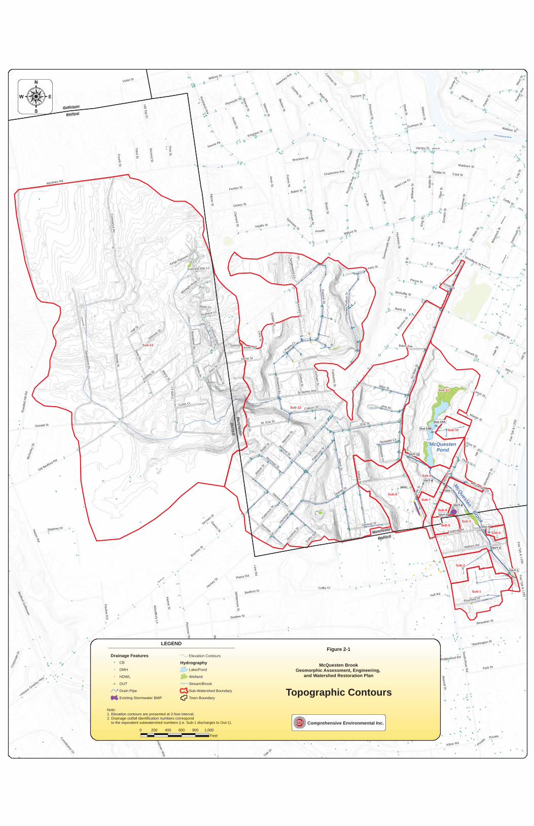
2-1
Section 2 Watershed Descr iption This section describes the contributing watershed to McQuesten Brook, including its size and boundaries and characteristics such as land use, impervious cover and soils, all of which are important in estimating pollutant loads and possible measures to control these pollutant loads.
2.1 Watershed and Subwatershed Delineations The watershed area to McQuesten Brook was delineated using two foot contour maps and stormwater drainage infrastructure maps provided by the City of Manchester and the Town of Bedford. This was refined through meetings with Manchester City officials and field investigations of the stormwater drainage network. As a result of these investigations, the watershed area was delineated as 563 acres in Manchester and Bedford.
Field investigations and watershed delineation revealed that an unnamed tributary that once fed Bowman Brook is now piped to the South Main Street discharge, which accounts for the size of the watershed. The unnamed tributary starts at Constance Street in Bedford and runs about 7,500 feet (two branches) before entering Manchester’s piped drainage system at Saint James Avenue in Manchester. The unnamed tributary is piped about 3,200 feet and outlets at the South Main Street pipe (McQuesten Brook). The watershed boundaries along South River Road at the intersection of Colby Court were further refined with the assistance of New Hampshire Department of Environmental Services (NHDES) staff who were able to investigate structures along this busy road.
The watershed was further delineated into 13 subwatersheds for pollutant modeling purposes. For the most part, the subwatersheds represent drainage areas to stormwater outfalls to McQuesten Brook and a few represent overland runoff into the brook or its tributary. Refer to Figure 2-1 for a topographic map showing watershed and subwatershed boundaries with storm drain infrastructure.
2.2 Land Uses/I mpervious Area Land uses within the watershed vary significantly between the upper and lower watersheds. The upper watershed is primarily residential, while the lower watershed, south of South Main Street where McQuesten Brook emerges, is intensely developed with a mix of commercial and residential land uses. Figure 2-2 shows a breakdown of land uses throughout the watershed. An aerial view of the watershed with watershed boundaries is provided on Figure 2-3. Table 2-1 provides a breakdown of land use by subwatershed, along with impervious areas. Further description of each subwatershed and potential pollutant sources are provided in Section 4.0.
McQuesten Brook Geomorphic Assessment and Watershed Restoration Plan Final Report: October 1, 2013

2-2
Table 2-1. McQuesten Brook Watershed Land Use Area (acres)
Land Use
%
Impe
rvio
us1
Sub-
1
Sub-
2
Sub-
3
Sub-
4
Sub-
5
Sub-
6
Sub-
7
Sub-
8
Sub-
9
Sub-
10
Sub-
11
Sub-
12
Sub-
13
Tot
al
Single family/duplex residential2 0.01 0.46 5.61 0.24 0.00 0.00 1.31 4.30 1.84 0.00 2.90 119.58 105.20 241.46 Single Family Parcels <0.25 acres 51% 0.01 0.00 0.00 0.24 0.00 0.00 1.31 0.00 0.00 0.00 0.00 113.60 5.26 120.42 Single Family Parcels 0.25 - 1.0 acres 38% 0.00 0.46 5.61 0.00 0.00 0.00 0.00 4.30 1.84 0.00 2.90 5.98 84.16 105.25 Single Family Parcels >1.0 acres 19% 0.00 0.00 0.00 0.00 0.00 0.00 0.00 0.00 0.00 0.00 0.00 0.00 15.78 15.78 Multi-family residential2 0.00 0.00 2.24 0.00 0.00 0.00 0.00 0.58 0.00 0.00 1.01 8.98 11.16 23.97 Multiple Units (Condos, Apartments) 51% 0.00 0.00 2.24 0.00 0.00 0.00 0.00 0.00 0.00 0.00 0.00 0.00 10.05 12.29 Single Unit (Duplex) 38% 0.00 0.00 0.00 0.00 0.00 0.00 0.00 0.58 0.00 0.00 1.01 8.98 1.12 11.68 Agricultural land 2% 0.00 0.00 0.00 0.00 0.00 0.00 0.00 0.00 0.00 0.00 0.00 0.00 44.45 44.45 Brush 6% 0.01 0.00 5.51 0.22 0.001 0.00 0.00 0.00 0.00 0.00 0.00 1.48 3.32 10.54 Cemeteries 11% 0.00 0.00 0.00 0.00 0.00 0.00 0.00 0.00 0.00 0.00 0.00 4.66 34.92 39.58 Commercial 76% 9.41 4.18 3.54 0.57 2.18 0.97 2.33 5.87 1.96 2.45 6.57 0.38 1.20 41.61 Disturbed Land 11% 0.00 0.00 0.00 0.00 0.00 0.00 0.00 0.00 0.00 0.00 0.00 0.00 0.90 0.90 Educational 34% 0.00 0.00 0.00 0.00 0.00 0.00 0.00 0.00 0.00 0.00 0.00 4.23 0.00 4.23 Forest land 1.9% 0.00 0.00 0.48 0.00 0.00 0.00 0.10 2.28 1.85 0.00 10.84 23.25 72.84 111.64 Outdoor recreation 11% 0.00 0.00 0.00 0.00 0.00 0.00 0.00 0.00 0.00 0.00 3.44 0.00 0.00 3.44 Road Transportation 98% 0.39 0.02 1.22 0.07 0.00 0.00 2.02 1.26 0.11 0.00 0.05 20.49 11.42 37.05 Water 0% 0.00 0.00 0.00 0.00 0.00 0.00 0.00 0.00 0.00 0.00 2.10 0.00 0.00 2.10 Wetlands 1.9% 0.00 0.00 0.99 0.00 0.00 0.00 0.00 0.00 0.00 0.00 0.66 0.00 0.00 1.65
Total 9.83 4.66 19.60 1.10 2.18 0.97 5.76 14.28 5.75 2.45 27.57 183.05 285.42 562.63 Impervious Area 7.55 3.37 7.53 0.64 1.66 0.74 4.42 7.59 2.33 1.86 7.11 86.48 61.74 193.01
Percent Impervious Area 77% 72% 38% 58% 76% 76% 77% 53% 40% 76% 28% 47% 22% 34% 1Source: Estimating Change in Impervious Area (IA) and Directly Connected Impervious Areas (DCIA) for New Hampshire Small MS4 Permit. Small MS4 Permit Technical Support Document, April 2011. http://www.epa.gov/region1/npdes/stormwater/nh/NHDCIA.pdf. 2 For the purpose of calculating the percent impervious area, multi-family residential and single family/duplex residential land uses were broken down further based on their density and level of imperviousness using ortho photo maps. These broken down classifications were not delineated on the GIS map.
McQuesten Brook Geomorphic Assessment and Watershed Restoration Plan Final Report: October 1, 2013

2-3
2.3 Soils and Groundwater Features Soils are typically classified into hydrologic soil groups (HSG) A through D. HSG A and B soils have the highest infiltration rates, allowing for greater stormwater recharge potential. HSG C and D soils are typically tighter soils, limiting recharge potential. This information is important when selecting stormwater best management practices (BMPs) to treat stormwater runoff, as infiltration BMPs typically offer better pollutant removal while minimizing the volume of stormwater runoff and increasing the volume of water that recharges groundwater baseflow. Infiltration BMPs also reduce the amount of warm stormwater runoff that enters the brook during the summer months, keeping the brook cooler, which is extremely important to the cold water eastern native brook trout population.
Most of the watershed contains HSG A and B soils, providing excellent opportunity for stormwater infiltration treatment measures throughout the watershed. The area immediately surrounding McQuesten Brook and McQuesten Pond are C and D soils, which is typical of stream buffer areas where groundwater is shallow. The corridor along Second Street is identified as Urban Fill, indicating the area was filled when it was developed. Refer to Figure 2-4 for soil characteristics in the watershed.
Also note that while the soils immediately surrounding McQuesten Brook have shallow groundwater depths and are less permeable, steep banks on the west side of the brook provide greater depth to groundwater in the adjacent developed areas. This combined with HSG A soils provide opportunity for stormwater recharge in these areas.
2.4 Stormwater and Sewer I nfrastructure The known and available mapped stormwater infrastructure throughout the watershed is shown on Figure 2-1, along with stormwater outfalls. This was used to help delineate the watershed and subwatersheds.
The headwaters to the brook begin in Bedford, New Hampshire as an unnamed tributary that runs about 7,500 feet before it enters Manchester’s piped drainage system, where it is carried underground for about 3,200 feet before it daylights under South Main Street. It is at this point the brook is referred to as McQuesten Brook.
After the South Main Street culvert, McQuesten Brook passes through four additional culverts before discharging to the Merrimack River. These culvert crossings, from upstream to downstream, include:
• Second Street culvert; • Eastman Avenue culvert; • Wathen Road culvert; and • I-293 culvert
McQuesten Brook Geomorphic Assessment and Watershed Restoration Plan Final Report: October 1, 2013

2-4
Further description and assessment of culvert crossings are provided in Section 3.0.
As shown on Figure 2-1, there are eight stormwater outfalls into McQuesten Brook between South Main Street and the Merrimack River, and two into McQuesten Pond. These allow untreated stormwater runoff to enter the pond and brook.
Figure 2-5 shows the sewer infrastructure in the watershed. Its location is important when designing and constructing stormwater BMPs and other improvements in the watershed.
McQuesten Brook Geomorphic Assessment and Watershed Restoration Plan Final Report: October 1, 2013
")
")")")")
!(") ")
!(")
")
!(")")
")") !(!(")
") ") ")!( !(
")")
")
!(
")")")")!(
")") ")
!( ")")!(")")
")") ")!(")
")") !( #*")")!(
!(!( ")") !(!(
")!(
")")!(!(
")")")")
!( ")") ")!( ")")") ")") ")
!( ")
") ")")") !(!( ")")
")")
") #*")!( ")!( #* ")!(
")")
")
")") ") ")!(") ")") ")
")") ") !(")") ")") !(!(") !( ")")
")!(
") ")")")!(")") #*!(
") ")!(!(
!( ")")!(") ")") ")")") !( ") !(")") !(
") !( ") ")!(")")#* !(") ")
") ")")
") ")!( !(")!( ")")")") ")")!(")
")
")")") !(") ")") !( !( #*")
")!( ")
!(")!(")")")
!(")
")")
!(")") ")!(")")")
!( ")!( !(
") ") #*")")!(!(
") ")
")")") !(") ")") ") !(!(")")")
")") !(")#*
")")") ") !(!( ")")
!(") ")
!(!( ") !( !(!( ")") ")
!( ")!(
") ")
")
")!(
!(") ")")
") ")!(") !(")
")
")")")
")")
") ")
!(
")
!(!(")
")#*!(")!(
") ") ")!( ")!(
")!( #*
")!(
") !( ")")")
")!(
!(")
") ")")#* ") ")") ")
")")
")!(
")")#* !(
") !( ")") ")")")!(")")#*") ") ")")") ") ")!(") !( !(") ") ") ")!( ")") !(!(") ")") #*!( ") !(
")#* ")!( ")") ") ")!( !(
!( ") !(
#*") ") ")")!(!( ") ")!(#* ")
!(") ")") ") ")")
")!( ")")
")")")
")#* !(
") ")")!(")") ")!( ") ")")!( ")") ")!(!(") ") ")
") ")")!( ")") ")") !(") ")")") ")
!(")") ")")!( !(
")")") ")") ")") ")") !(!( !(")
")!(!( ")
")")")
!(")
") !(!(")
")")") ") ")")
!( !(!( ")") ")") ")") ")") ")")!(!( ") !(
") ")!( !( ") ")")")")
")!(!(")") ")
!( !(") ")!(!( ")!(
!(") !( !( ")
")")") !(")") !(")")") ")")") ")!( ")") ")!(
")") ")") !( ")!( !(")") ")")
!(")")")
!(!(") ")")") ")") ") !(")") !( !( ")")")
") ")!(
") !(!(
") !(!(
")")!( !(
") ")!(
")") ")!(") ")!( !(")")") ") !(") !( !( ")") ")!( !(
") ")!( !(!(") ")")!(") !(")!(!(
")
")") ")") ")!(") ")!(
")!(") ")
!( ")") ")!(")
!(!( ")!(") ") !(!(") ")
")!(!( !( ")!( ")") ") ") !(")")!(!( !(")
!(") !(")")!(!(!(")
")
") ")")")!(
!(!( !(") !(")")")!( ")") ")")!( !(") ")
!(!( ")")
")")!( !(")")
")") !(!(")
")")")
") ") !(") ")!( ")!(") !( ")
") !(") ")
")!(!( ")")")
")!(") ")!(
") !( ")!(
")")")!(")
!(!(
")")") ")
")!( !(")")")
!(")
") !(")!(")
!(!(")")
!( ")") !(")
")!(")
")")!( ")
") ")!(
!( !( !(!(") ")") ")")!( ")")
")!( ")")") !(!( ")")")") ")!(")!(")
!(") ")
") ")")") ")") ") ")")
") ")!( ")") ")") ")") ") ")")") ") !(!(")!( !( ") ") !(!( ")") ")") !( !(") ")!( ")!(") !( !( ")") !(") !(") ") ")!( !( ")")") ")!(") !( !(
") ")") !(!(") ")") ")!(
!( !( !(!(") ")")
!(!(")") !(!(!( !(")
")")!(") ") #*") #*!( ") !(") #*") ") !(") !(!( !(")!(") !(") !(")") ")!( ")!( !(")") !(!(
!(")!(") !( !(")")!(") !(!(") ")
!(") ")!(")
!(") ")")")#*") ") ") !(") ")
")")
")")")
!(")
") ")") !(") !(!( ")
")")")")
")!(")!(
!(")") ")") ")") ")
")!(
")!(
")!(") ")")
")")!( ") ")")") !(
")")") ")")!( ")
!(")")") !(") ")")!(
!(") ") ")")!( ")") !(
")")")!(
!( !( ") ")")") !(") !(") !(")!(
") ")")
!( !(")")
") !(!(
")!( ")") ")
") !(!(")") ") ")")!(!(
!(")")
#*
")
")
")
")
")
")
")
")
")")
")
")
")
")
")
")
")
")
")
")
")
")
")
")
")
")
")
")
")
")
")
")
")
")
")
")")
")
")
")
")
")
")
")
")
")
")
")
")
")
")
")
")")
")")
")
")
")
")
")
")
")
")
")
")
")
")
")
")
")
")
")
")
")
")
")
")
")
")")
")
")
")
")
")
")
")
")")
")
")
")
")
")
")
")
")
")")
")
")
")
")
")
")
")")
")")
")
")")
")
")
")
")
")
")
")
")")
")
")")
")")
")")
")
")
")
")
")
")
")
")
")
")
")
")
")
")
")
")
")")
")
")
")
")")
")")
")
")
")
")
")")
")
")
")
")
")")
")
")
")
")")
")")
")
")")
")
")
")
")
")
")
")")
")
")
")
")
")
")
")
")")")")
")
")")
")
")
")
")
")
")
")
")
")
")
")
")
")
")
")
")
")
")")
")
")
")")
")
")
")
")
")
")
")")
")
")
")
")
")
")
")
")
")
")
")
")
")
")
")")
")
")
")
")
")
")
")
")
")")
")
")
")
")
")
")
")
")
")
")
")
")
")
")")
")
")
")
")
")
")
")
")
")
")
")")
")
")
")")
")
")
")
")
") ")
")
")
")
")
")")
")
")
")
")")
")
")
")
")
")")
")
")
")
")
")
")
")
")
")
")
")
")")
")
")
")
")
")
")
")
")
")
")
")
")
")
")
")
")") ")")
")
")
")
")
")
")
")
")
")")
")
")
")
")
")
")
")
")
")")
")
")
")
")
")
")
")
")
")
")
")
")
")
")
")")
")
")
")
")")
")")
")
")
")
")
")")
")
")
")
")
")
")
")
")
")
")")
")
")
")
")
")")
")
")
")
")
")
")
")")
")")
") ")
")")
")
")
")")")")
")")
")
")")")
")
")
")
")
")
")
")")
")
")")
")")
")
")
")
")
")
")
")
")
")
")
")
")
")")
")
")
")
")
")
#*#*
#*
#*
#*
#*
")
#*
#*
#*
#*
#*
#*
#*
#*
#*
#*
#*
#*
!(
!(#*
!(
!(
!(
!(
")
")
")
")
")
")
#*
#*
#*
")")")
!(") ")
!(")
")
!(")")
")") !(!(")
") ")!( !(
")")
")
!(
")")")!(
")") ")
!( ")")!(")")
")") ")!(")
") !(")")!(
!(!( ")") !(!(
")!(
")")!(!(
")")")")
!( ")")
")
!( ")")") ")") ")
!( ")
") ")")")
!( ")")")
")
")!( ")!( #* ")!(
")")
")
")") ") ")!(") ")") ")
")") ")")") ")") !(
") !( ")")")
") ")")")!(")
!( ")")") ")") ")
") !( ")")") !(") !( ") ")!(")
")#*") ")
") ")")
") ")!(")!(")")")
")!(")")
")")
") ") !(
")!( ")
!(")!(")")")
!(
")
!(")") ")!(")")")
!( ")!( !(
") ")
")!(!(
") ")
")")") !(") ")") ") !(!(")")")
")")")#*
")
") ")!( ")
!(") ")
!(!( ") !( !(!( ")") ")
!( ")!(
") ")
")
")!(
") ")")")
!(")")
")
")")
")")
")
!(
")!(")
!(
")")
!(")
")#*
")!(
#*") !( ")")
")!(")")#*") ")")") !(") ")
!(")") ")") #*!(
")#* ")!( ") ")!( !(
!( ")
#*") ")
!(#*
") ")") ") ")
#*")")!(
")")") !(
")")")!(
") ")!( !(")
")!(
!(
")")")
!( !(")
")")
!( !(
!(!( ")!(
")")") ")")") ")
!(") ")!(
")
")
!(")")")
")
")
")
")
")
")
")
")
")
")
")
")
")
")
")
")
")")
")
")
")
")
")
")
")
")
")
")
")
")
")")
")
")
")
")")
")")
")
")
")
")
")")
")
")
")
")")
")
")
")
")")
")")
")
")")
")
")
")")")
")
")
")
")
")
")
")
")
")
")
")
")
")
")
")
")
")
#*
#*
#*
#*
")
#*
#*
#*
#*
#*
#*
#*
")
")
")
")
")
")
#*
#*
#*
#*
#*
Out-7
OUT-6
OUT-5
Out-4
OUT-2
OUT-1
OUT-8
OUT-12
Out-10B
Out-10A
Boynton St
N H 101 By-pass
Varney St
Piscataquog River
Milford St
Woodbury St
Dartm
outh
St
Whe
eloc
k St
Goffe St
Sandstone Dr
Bedford
Manchester
Bedford
Goffstown
BedfordManchester
McQuesten Brook
McQuestenPond
Sub-13
Sub-12
Sub-11
Sub-3
Sub-8
Sub-1
Sub-7
Sub-9
Sub-2
Sub-5
Sub-10
Sub-4
Sub-6
Donald St
Palomino Ln
Varney St
So M
ain
St
Boynton St
Run
dlet
t Hill
Rd
Seco
nd S
t
Milford St
Worthley Rd
Allen St
Colby Ct
N H 101 By-pass
South River R
d
Plumm
er Rd
Seabee St
Ridgewood Rd
Hazen R
d
Wilkins St
B St
Mast Rd
A St
Salem S
t
Kilton Rd
Brock St
Erie St
Oneida St
Hill S
t
Gilford S
t
Ruth St
Savoie St
Sandstone Dr
Head St
So. M
ain
St
Constance Av
Winter St
Sylvester St
Mack S
t
St James Ave
Avon St
Bismark S
t
C St
Bow
man
St
Hersey S
t
Huntress S
t
Warner St
Forest St
Old Bedford Rd
Rockland Ave
Park Dr
Glenwood Ave
Becker St
Plymouth St
Cur
tis L
n
Pasture Dr
Harvell St
Alpine St
Harrim
an S
t
Precourt St
Darling St
Fee Tpk & I-293
Swan Av
Almond St
Rid
dle
St
Crim
son Glory
Stewart St
Carroll St
Atwood D
r
Dickey St
Willi
ams
St
Bedford Goffstow
n
Bedford St
Woodbury Ln
Wathen Rd
Whittem
ore St
Jam
es P
ollo
ck D
r
Eastman Av
Ingalls St
Coburn St
George St
Wen
twor
th S
t
Lenz St
Woodbury St
Whe
eloc
k St
D St
Fenton St
Dartm
outh
St
Roc
helle
Ave
Stephen Dr
Poor St
Servant S
t
Park
er S
t
Beaudoin St
McDuffie St
Constitution Dr
Bedel
St
Kingston St
004 C
Leandre St
Lewis St
Thorp St
Wayside D
r
Tilto
n St
Prince St
Violet St
Dery St
W. Erie St
Hull Rd
McK
erle
y St
Austin St
Goffe St
Denis St
Hale
St
Log
St
Prairie Ct
Pauline Ext
Sheridan St
Balch Ave
Third St
Keene St
McQuesten St
Geneva St
Master St
Gra
nite
St
First St
Johnson St
Clem
ent St
Charleston Ave
Rose Terr
Granby St
Woodlaw
n Av
Curtis Ct
Private
Patter
son S
t
Ann Av
Riverway Pl
Fourth St
Bank St
Card St
Line Rd
Washington Pl
Davies St
Comeau St
Hall St
Wes
t St
Brockton St
Wendover W
ay
Sum
mer
side
Ave
Cor
pora
te D
r
Cooper S
t
Plains Rd
Donah
ue S
t
Oxford St
Abbott
St
Wason S
t
Sherman St
Dunlap S
tArnold St
Gorham
St
Sweeney Ave
Tanglewood C
ir
Marsto
n St
Horace Greeley Hwy
Babel St
Hill Top D
r
Merry St
King
St
Fairbanks St
Shawm
ut Av
Nourie Pk
Park
er A
ve
Lawes Av
Bris
ton
Ct
Leach St
Janet Lee Ct
Newgate Cir
Griffin
St
Schiller St
Demers St
Dunham St
Riddle Pl
Suffolk Ct
Gendron St
Pimlico C
t
Gro
ndin
St
Briston Manor
Promice Ln
Wallace St
Asco
t Ct
Oak Dr
Rockingham
Ct
Kings Ransom Ln
Monlight Rose
Ln
Belm
ont C
tSa
raso
ta C
t
Marlboro St
Rose Ln
Churchill Ct
Evening Star Ln
Patter
son S
t
Priv
ate
Hale
St
New
gate Cir
Private
Private
Boynto
n St
Fee Tpk & I-293
Second St
Roc
helle
Ave
Fee
Tpk
& I-2
93
Private
Boynto
n St
Hill
St
:
0 200 400 600 800 1,000Feet
Topographic Contours
McQuesten BrookGeomorphic Assessment, Engineering,
and Watershed Restoration Plan
Figure 2-1LEGEND
Drainage Features") CB!( DMH
#* HDWL
#* OUT
Drain Pipe
Existing Stormwater BMP
Elevation Contours
HydrographyLake/Pond
Wetland
Stream/Brook
Sub-Watershed Boundary
Town Boundary
1. Elevation contours are presented at 2-foot interval.2. Drainage outfall identification numbers correspond to the equivalent subwatershed numbers (i.e. Sub-1 discharges to Out-1).
Note:
Comprehensive Environmental Inc.

")
")")")")
!(") ")
!(")
")
!(")")
")") !(!(")
") ") ")!( !(
")")
")
!(
")")")")!(
")") ")
!( ")")!(")")
")") ")!(")
")") !( #*")")!(
!(!( ")") !(!(
")!(
")")!(!(
")")")")
!( ")") ")!( ")")") ")") ")
!( ")
") ")")") !(!( ")")
")")
") #*")!( ")!( #* ")!(
")")
")
")") ") ")!(") ")") ")
")") ") !(")") ")") !(!(") !( ")")
")!(
") ")")")!(")") #*!(
") ")!(!(
!( ")")!(") ")") ")")") !( ") !(")") !(
") !( ") ")!(")")#* !(") ")
") ")")
") ")!( !(")!( ")")")") ")")!(")
")
")")") !(") ")") !( !( #*")
")!( ")
!(")!(")")")
!(")
")")
!(")") ")!(")")")
!( ")!( !(
") ") #*")")!(!(
") ")
")")") !(") ")") ") !(!(")")")
")") !(")#*
")")") ") !(!( ")")
!(") ")
!(!( ") !( !(!( ")") ")
!( ")!(
") ")
")
")!(
!(") ")")
") ")!(") !(")
")
")")")
")")
") ")
!(
")
!(!(")
")#*!(")!(
") ") ")!( ")!(
")!( #*
")!(
") !( ")")")
")!(
!(")
") ")")#* ") ")") ")
")")
")!(
")")#* !(
") !( ")") ")")")!(")")#*") ") ")")") ") ")!(") !( !(") ") ") ")!( ")") !(!(") ")") #*!( ") !(
")#* ")!( ")") ") ")!( !(
!( ") !(
#*") ") ")")!(!( ") ")!(#* ")
!(") ")") ") ")")
")!( ")")
")")")
")#* !(
") ")")!(")") ")!( ") ")")!( ")") ")!(!(") ") ")
") ")")!( ")") ")") !(") ")")") ")
!(")") ")")!( !(
")")") ")") ")") ")") !(!( !(")
")!(!( ")
")")")
!(")
") !(!(")
")")") ") ")")
!( !(!( ")") ")") ")") ")") ")")!(!( ") !(
") ")!( !( ") ")")")")
")!(!(")") ")
!( !(") ")!(!( ")!(
!(") !( !( ")
")")") !(")") !(")")") ")")") ")!( ")") ")!(
")") ")") !( ")!( !(")") ")")
!(")")")
!(!(") ")")") ")") ") !(")") !( !( ")")")
") ")!(
") !(!(
") !(!(
")")!( !(
") ")!(
")") ")!(") ")!( !(")")") ") !(") !( !( ")") ")!( !(
") ")!( !(!(") ")")!(") !(")!(!(
")
")") ")") ")!(") ")!(
")!(") ")
!( ")") ")!(")
!(!( ")!(") ") !(!(") ")
")!(!( !( ")!( ")") ") ") !(")")!(!( !(")
!(") !(")")!(!(!(")
")
") ")")")!(
!(!( !(") !(")")")!( ")") ")")!( !(") ")
!(!( ")")
")")!( !(")")
")") !(!(")
")")")
") ") !(") ")!( ")!(") !( ")
") !(") ")
")!(!( ")")")
")!(") ")!(
") !( ")!(
")")")!(")
!(!(
")")") ")
")!( !(")")")
!(")
") !(")!(")
!(!(")")
!( ")") !(")
")!(")
")")!( ")
") ")!(
!( !( !(!(") ")") ")")!( ")")
")!( ")")") !(!( ")")")") ")!(")!(")
!(") ")
") ")")") ")") ") ")")
") ")!( ")") ")") ")") ") ")")") ") !(!(")!( !( ") ") !(!( ")") ")") !( !(") ")!( ")!(") !( !( ")") !(") !(") ") ")!( !( ")")") ")!(") !( !(
") ")") !(!(") ")") ")!(
!( !( !(!(") ")")
!(!(")") !(!(!( !(")
")")!(") ") #*") #*!( ") !(") #*") ") !(") !(!( !(")!(") !(") !(")") ")!( ")!( !(")") !(!(
!(")!(") !( !(")")!(") !(!(") ")
!(") ")!(")
!(") ")")")#*") ") ") !(") ")
")")
")")")
!(")
") ")") !(") !(!( ")
")")")")
")!(")!(
!(")") ")") ")") ")
")!(
")!(
")!(") ")")
")")!( ") ")")") !(
")")") ")")!( ")
!(")")") !(") ")")!(
!(") ") ")")!( ")") !(
")")")!(
!( !( ") ")")") !(") !(") !(")!(
") ")")
!( !(")")
") !(!(
")!( ")") ")
") !(!(")") ") ")")!(!(
!(")")
#*
")
")
")
")
")
")
")
")
")")
")
")
")
")
")
")
")
")
")
")
")
")
")
")
")
")
")
")
")
")
")
")
")
")
")
")")
")
")
")
")
")
")
")
")
")
")
")
")
")
")
")
")")
")")
")
")
")
")
")
")
")
")
")
")
")
")
")
")
")
")
")
")
")
")
")
")
")
")")
")
")
")
")
")
")
")
")")
")
")
")
")
")
")
")
")
")")
")
")
")
")
")
")
")")
")")
")
")")
")
")
")
")
")
")
")
")")
")
")")
")")
")")
")
")
")
")
")
")
")
")
")
")
")
")
")
")
")
")
")")
")
")
")
")")
")")
")
")
")
")
")")
")
")
")
")
")")
")
")
")
")")
")")
")
")")
")
")
")
")
")
")
")")
")
")
")
")
")
")
")
")")")")
")
")")
")
")
")
")
")
")
")
")
")
")
")
")
")
")
")
")
")
")")
")
")
")")
")
")
")
")
")
")
")")
")
")
")
")
")
")
")
")
")
")
")
")
")
")
")")
")
")
")
")
")
")
")
")
")")
")
")
")
")
")
")
")
")
")
")
")
")
")
")")
")
")
")
")
")
")
")
")
")
")
")")
")
")
")")
")
")
")
")
") ")
")
")
")
")
")")
")
")
")
")")
")
")
")
")
")")
")
")
")
")
")
")
")
")
")
")
")
")")
")
")
")
")
")
")
")
")
")
")
")
")
")
")
")
")") ")")
")
")
")
")
")
")
")
")
")")
")
")
")
")
")
")
")
")
")")
")
")
")
")
")
")
")
")
")
")
")
")
")
")
")")
")
")
")
")")
")")
")
")
")
")
")")
")
")
")
")
")
")
")
")
")
")")
")
")
")
")
")")
")
")
")
")
")
")
")")
")")
") ")
")")
")
")
")")")")
")")
")
")")")
")
")
")
")
")
")
")")
")
")")
")")
")
")
")
")
")
")
")
")
")
")
")
")
")")
")
")
")
")
")
#*#*
#*
#*
#*
#*
")
#*
#*
#*
#*
#*
#*
#*
#*
#*
#*
#*
#*
!(
!(#*
!(
!(
!(
!(
")
")
")
")
")
")
#*
#*
#*
")")")
!(") ")
!(")
")
!(")")
")") !(!(")
") ")!( !(
")")
")
!(
")")")!(
")") ")
!( ")")!(")")
")") ")!(")
") !(")")!(
!(!( ")") !(!(
")!(
")")!(!(
")")")")
!( ")")
")
!( ")")") ")") ")
!( ")
") ")")")
!( ")")")
")
")!( ")!( #* ")!(
")")
")
")") ") ")!(") ")") ")
")") ")")") ")") !(
") !( ")")")
") ")")")!(")
!( ")")") ")") ")
") !( ")")") !(") !( ") ")!(")
")#*") ")
") ")")
") ")!(")!(")")")
")!(")")
")")
") ") !(
")!( ")
!(")!(")")")
!(
")
!(")") ")!(")")")
!( ")!( !(
") ")
")!(!(
") ")
")")") !(") ")") ") !(!(")")")
")")")#*
")
") ")!( ")
!(") ")
!(!( ") !( !(!( ")") ")
!( ")!(
") ")
")
")!(
") ")")")
!(")")
")
")")
")")
")
!(
")!(")
!(
")")
!(")
")#*
")!(
#*") !( ")")
")!(")")#*") ")")") !(") ")
!(")") ")") #*!(
")#* ")!( ") ")!( !(
!( ")
#*") ")
!(#*
") ")") ") ")
#*")")!(
")")") !(
")")")!(
") ")!( !(")
")!(
!(
")")")
!( !(")
")")
!( !(
!(!( ")!(
")")") ")")") ")
!(") ")!(
")
")
!(")")")
")
")
")
")
")
")
")
")
")
")
")
")
")
")
")
")
")")
")
")
")
")
")
")
")
")
")
")
")
")
")")
")
")
")
")")
")")
")
")
")
")
")")
")
")
")
")")
")
")
")
")")
")")
")
")")
")
")
")")")
")
")
")
")
")
")
")
")
")
")
")
")
")
")
")
")
")
#*
#*
#*
#*
")
#*
#*
#*
#*
#*
#*
#*
")
")
")
")
")
")
#*
#*
#*
#*
#*
Out-7
OUT-6
OUT-5
Out-4
OUT-2
OUT-1
OUT-8
OUT-12
Out-10B
Out-10A
Boynton St
Coburn St
W. Erie St
N H 101 By-pass
Varney St
Piscataquog River
Milford St
Woodbury St
Dartm
outh
St
Whe
eloc
k St
Goffe St
Donald St
Old Bedford Rd
Sandstone Dr
Bedford
Manchester
Bedford
Goffstown
BedfordManchester
McQuesten Brook
McQuestenPond
Sub-13
Sub-12
Sub-11
Sub-3
Sub-8
Sub-1
Sub-7
Sub-9
Sub-2
Sub-5
Sub-10
Sub-4
Sub-6
Donald St
Varney St
Palomino Ln
So M
ain
St
Boynton St
Run
dlet
t Hill
Rd
Seco
nd S
t
Milford St
Worthley Rd
Allen St
N H 101 By-pass
Colby Ct
Seabee St
South River R
d
Plumm
er Rd
Hazen Rd
Ridgewood Rd
B S
t
Wilkins St
Mast Rd
A St
Salem St
Kilton Rd
Brock St
Erie St
Oneida St
Hill
St
Head St
Gilford St
Ruth St
Savoie St
So. M
ain
St
Sandstone Dr
Constance Av
Winter St
Mack St
C St
St James Ave
Sylvester St
Hersey St
Avon St
Bow
man
St
Bism
ark St
Warner St
Huntress St
Forest St
Old Bedford Rd
Park Dr
Rockland Ave
Glenwood Ave
Becker St
Pasture Dr
Harvell St
Plymouth St
Fee Tpk & I-293
Alpine St
Curtis Ln
Harrim
an S
t
Darling St
Precourt St
Swan Av
Almond St
Rid
dle
St
Stewart St
Crimson G
lory
Carroll StDickey St
Atw
ood Dr
Will
iam
s St
Wathen Rd
Bedford Goffstow
n
Bedford StWhittem
ore St
Woodbury Ln
Eastman Av
Jam
es P
ollo
ck D
r
Ingalls St
Coburn St
George St
Lenz St
D St
Wen
twor
th S
tW
heel
ock
St
Woodbury St
Fenton St
Dartm
outh
St
Stephen Dr
Roch
elle
Ave
Poor St
Servant St
Parker St
004 C
McDuffie St
Bedel
St
Beaudoin St
Constitution Dr
Leandre St
Kingston St
Wayside D
r
Lewis St
W. Erie St
Thorp St
Dery St
Prince St
Violet St
Tilto
n St
Hull Rd
McK
erle
y St
Hale
St
Denis St
Goffe St
Keene St
Log
St
Austin St
Prairie Ct
Sheridan St
Pauline Ext
Geneva St
McQuesten St
Balch Ave
Master St
Third St
Gran
ite S
t
Clem
ent St
First St
Johnson St
Charleston Ave
Rose Terr
Granby St
Woodlaw
n Av
Private
Curtis Ct
Patter
son S
t
Ann Av
Riverway Pl
Fourth St
Bank St
Card St
Comeau St
Davies St
Line
Rd
Wes
t St
Hall St
Washington Pl
Wendover W
ay
Brockton St
Sum
mer
side
Ave
Corp
orat
e Dr
Cooper St
Plains Rd
Donah
ue S
t
Wason St
Oxford St
Sherman St
Abbot
t St
Sweeney Ave
Gorham
St
Horace Greeley Hwy
Arnold St
Marsto
n St
Tang
lew
ood
Cir
Babel St
Hill Top D
r
Merry St
Fairbanks St
Kin
g St
Shawm
ut Av
Nourie Pk
Lawes Av
Janet Lee Ct
Leach St
Newgate Cir
Bris
ton
Ct
Griffin
St
Schiller St
Demers St
Dunham St
Riddle Pl
Suffolk Ct
Pimlico C
t
Gro
ndin
St
Wallace St
Briston Manor
Promice Ln
Oak Dr
Asco
t Ct
Rockingham Ct
Kings Ransom Ln
Monlight R
ose Ln
Belmon
t Ct
Sara
sota
Ct
Marlboro St
Rose Ln
Churchill Ct
Evening Star Ln
Patter
son S
t
Priv
ate
Hale
St
Newgate Cir
Private
Private
Boynt
on S
t
Fee Tpk & I-293
Second St
Roc
helle
Ave
Fee
Tpk
& I-
293
Private
Boynt
on S
t
Hill
St
0 200 400 600 800 1,000Feet
Land Use Characteristics
McQuesten BrookGeomorphic Assessment, Engineering,
and Watershed Restoration Plan
Figure 2-2
Comprehensive Environmental Inc.
Drainage Features") CB!( DMH#* HDWL
#* OUT
Drain Pipe
Existing Stormwater BMP
Sub-Watershed Boundary
Town Boundary
HydrographyLake/Pond
Wetland
Stream/Brook
Land Use - STEPL CategoriesCommercial
Forest
Institutional
Single-Family
Multi-Family
Open Space
Pastureland
Transportation
Disturbed Land
Water
LEGEND
1. Drainage outfall identification numbers correspond to the equivalent subwatershed numbers (i.e. Sub-1 discharges to Out-1).
Note:
:

")
")")")")
!(") ")
!(")
")
!(")")
")") !(!(")
") ") ")!( !(
")")
")
!(
")")")")!(
")") ")
!( ")")!(")")
")") ")!(")
")") !( #*")")!(
!(!( ")") !(!(
")!(
")")!(!(
")")")")
!( ")") ")!( ")")") ")") ")
!( ")
") ")")") !(!( ")")
")")
") #*")!( ")!( #* ")!(
")")
")
")") ") ")!(") ")") ")
")") ") !(")") ")") !(!(") !( ")")
")!(
") ")")")!(")") #*!(
") ")!(!(
!( ")")!(") ")") ")")") !( ") !(")") !(
") !( ") ")!(")")#* !(") ")
") ")")
") ")!( !(")!( ")")")") ")")!(")
")
")")") !(") ")") !( !( #*")
")!( ")
!(")!(")")")
!(")
")")
!(")") ")!(")")")
!( ")!( !(
") ") #*")")!(!(
") ")
")")") !(") ")") ") !(!(")")")
")") !(")#*
")")") ") !(!( ")")
!(") ")
!(!( ") !( !(!( ")") ")
!( ")!(
") ")
")
")!(
!(") ")")
") ")!(") !(")
")
")")")
")")
") ")
!(
")
!(!(")
")#*!(")!(
") ") ")!( ")!(
")!( #*
")!(
") !( ")")")
")!(
!(")
") ")")#* ") ")") ")
")")
")!(
")")#* !(
") !( ")") ")")")!(")")#*") ") ")")") ") ")!(") !( !(") ") ") ")!( ")") !(!(") ")") #*!( ") !(
")#* ")!( ")") ") ")!( !(
!( ") !(
#*") ") ")")!(!( ") ")!(#* ")
!(") ")") ") ")")
")!( ")")
")")")
")#* !(
") ")")!(")") ")!( ") ")")!( ")") ")!(!(") ") ")
") ")")!( ")") ")") !(") ")")") ")
!(")") ")")!( !(
")")") ")") ")") ")") !(!( !(")
")!(!( ")
")")")
!(")
") !(!(")
")")") ") ")")
!( !(!( ")") ")") ")") ")") ")")!(!( ") !(
") ")!( !( ") ")")")")
")!(!(")") ")
!( !(") ")!(!( ")!(
!(") !( !( ")
")")") !(")") !(")")") ")")") ")!( ")") ")!(
")") ")") !( ")!( !(")") ")")
!(")")")
!(!(") ")")") ")") ") !(")") !( !( ")")")
") ")!(
") !(!(
") !(!(
")")!( !(
") ")!(
")") ")!(") ")!( !(")")") ") !(") !( !( ")") ")!( !(
") ")!( !(!(") ")")!(") !(")!(!(
")
")") ")") ")!(") ")!(
")!(") ")
!( ")") ")!(")
!(!( ")!(") ") !(!(") ")
")!(!( !( ")!( ")") ") ") !(")")!(!( !(")
!(") !(")")!(!(!(")
")
") ")")")!(
!(!( !(") !(")")")!( ")") ")")!( !(") ")
!(!( ")")
")")!( !(")")
")") !(!(")
")")")
") ") !(") ")!( ")!(") !( ")
") !(") ")
")!(!( ")")")
")!(") ")!(
") !( ")!(
")")")!(")
!(!(
")")") ")
")!( !(")")")
!(")
") !(")!(")
!(!(")")
!( ")") !(")
")!(")
")")!( ")
") ")!(
!( !( !(!(") ")") ")")!( ")")
")!( ")")") !(!( ")")")") ")!(")!(")
!(") ")
") ")")") ")") ") ")")
") ")!( ")") ")") ")") ") ")")") ") !(!(")!( !( ") ") !(!( ")") ")") !( !(") ")!( ")!(") !( !( ")") !(") !(") ") ")!( !( ")")") ")!(") !( !(
") ")") !(!(") ")") ")!(
!( !( !(!(") ")")
!(!(")") !(!(!( !(")
")")!(") ") #*") #*!( ") !(") #*") ") !(") !(!( !(")!(") !(") !(")") ")!( ")!( !(")") !(!(
!(")!(") !( !(")")!(") !(!(") ")
!(") ")!(")
!(") ")")")#*") ") ") !(") ")
")")
")")")
!(")
") ")") !(") !(!( ")
")")")")
")!(")!(
!(")") ")") ")") ")
")!(
")!(
")!(") ")")
")")!( ") ")")") !(
")")") ")")!( ")
!(")")") !(") ")")!(
!(") ") ")")!( ")") !(
")")")!(
!( !( ") ")")") !(") !(") !(")!(
") ")")
!( !(")")
") !(!(
")!( ")") ")
") !(!(")") ") ")")!(!(
!(")")
#*
")
")
")
")
")
")
")
")
")")
")
")
")
")
")
")
")
")
")
")
")
")
")
")
")
")
")
")
")
")
")
")
")
")
")
")")
")
")
")
")
")
")
")
")
")
")
")
")
")
")
")
")")
")")
")
")
")
")
")
")
")
")
")
")
")
")
")
")
")
")
")
")
")
")
")
")
")
")")
")
")
")
")
")
")
")
")")
")
")
")
")
")
")
")
")
")")
")
")
")
")
")
")
")")
")")
")
")")
")
")
")
")
")
")
")
")")
")
")")
")")
")")
")
")
")
")
")
")
")
")
")
")
")
")
")
")
")
")
")")
")
")
")
")")
")")
")
")
")
")
")")
")
")
")
")
")")
")
")
")
")")
")")
")
")")
")
")
")
")
")
")
")")
")
")
")
")
")
")
")
")")")")
")
")")
")
")
")
")
")
")
")
")
")
")
")
")
")
")
")
")
")
")")
")
")
")")
")
")
")
")
")
")
")")
")
")
")
")
")
")
")
")
")
")
")
")
")
")
")")
")
")
")
")
")
")
")
")
")")
")
")
")
")
")
")
")
")
")
")
")
")
")
")")
")
")
")
")
")
")
")
")
")
")
")")
")
")
")")
")
")
")
")
") ")
")
")
")
")
")")
")
")
")
")")
")
")
")
")
")")
")
")
")
")
")
")
")
")
")
")
")
")")
")
")
")
")
")
")
")
")
")
")
")
")
")
")
")
")") ")")
")
")
")
")
")
")
")
")
")")
")
")
")
")
")
")
")
")
")")
")
")
")
")
")
")
")
")
")
")
")
")
")
")
")")
")
")
")
")")
")")
")
")
")
")
")")
")
")
")
")
")
")
")
")
")
")")
")
")
")
")
")")
")
")
")
")
")
")
")")
")")
") ")
")")
")
")
")")")")
")")
")
")")")
")
")
")
")
")
")
")")
")
")")
")")
")
")
")
")
")
")
")
")
")
")
")
")
")")
")
")
")
")
")
#*#*
#*
#*
#*
#*
")
#*
#*
#*
#*
#*
#*
#*
#*
#*
#*
#*
#*
!(
!(#*
!(
!(
!(
!(
")
")
")
")
")
")
#*
#*
#*
")")")
!(") ")
!(")
")
!(")")
")") !(!(")
") ")!( !(
")")
")
!(
")")")!(
")") ")
!( ")")!(")")
")") ")!(")
") !(")")!(
!(!( ")") !(!(
")!(
")")!(!(
")")")")
!( ")")
")
!( ")")") ")") ")
!( ")
") ")")")
!( ")")")
")
")!( ")!( #* ")!(
")")
")
")") ") ")!(") ")") ")
")") ")")") ")") !(
") !( ")")")
") ")")")!(")
!( ")")") ")") ")
") !( ")")") !(") !( ") ")!(")
")#*") ")
") ")")
") ")!(")!(")")")
")!(")")
")")
") ") !(
")!( ")
!(")!(")")")
!(
")
!(")") ")!(")")")
!( ")!( !(
") ")
")!(!(
") ")
")")") !(") ")") ") !(!(")")")
")")")#*
")
") ")!( ")
!(") ")
!(!( ") !( !(!( ")") ")
!( ")!(
") ")
")
")!(
") ")")")
!(")")
")
")")
")")
")
!(
")!(")
!(
")")
!(")
")#*
")!(
#*") !( ")")
")!(")")#*") ")")") !(") ")
!(")") ")") #*!(
")#* ")!( ") ")!( !(
!( ")
#*") ")
!(#*
") ")") ") ")
#*")")!(
")")") !(
")")")!(
") ")!( !(")
")!(
!(
")")")
!( !(")
")")
!( !(
!(!( ")!(
")")") ")")") ")
!(") ")!(
")
")
!(")")")
")
")
")
")
")
")
")
")
")
")
")
")
")
")
")
")
")")
")
")
")
")
")
")
")
")
")
")
")
")
")")
")
")
")
")")
")")
")
")
")
")
")")
")
")
")
")")
")
")
")
")")
")")
")
")")
")
")
")")")
")
")
")
")
")
")
")
")
")
")
")
")
")
")
")
")
")
#*
#*
#*
#*
")
#*
#*
#*
#*
#*
#*
#*
")
")
")
")
")
")
#*
#*
#*
#*
#*
Out-7
OUT-6
OUT-5
Out-4
OUT-2
OUT-1
OUT-8
OUT-12
Out-10B
Out-10A
Boynton St
N H 101 By-pass
Varney St
Piscataquog River
Milford St
Woodbury St
Dartm
outh
St
Whe
eloc
k St
Goffe St
Sandstone Dr
Bedford
Manchester
Bedford
Goffstown
BedfordManchester
McQuesten Brook
McQuestenPond
Sub-13
Sub-12
Sub-11
Sub-3
Sub-8
Sub-1
Sub-7
Sub-9
Sub-2
Sub-5
Sub-10
Sub-4
Sub-6
Donald St
Varney St
Palomino Ln
So M
ain
St
Boynton St
Run
dlet
t Hill
Rd
Seco
nd S
t
Milford St
Worthley Rd
Allen St
N H 101 By-pass
Colby Ct
Seabee St
South River R
d
Plumm
er Rd
Hazen Rd
Ridgewood Rd
B S
t
Wilkins St
Mast Rd
A St
Salem St
Kilton Rd
Brock St
Erie St
Oneida St
Hill
St
Head St
Gilford St
Ruth St
Savoie St
So. M
ain
St
Sandstone Dr
Constance Av
Winter St
Mack St
C St
St James Ave
Sylvester St
Hersey St
Avon St
Bow
man
St
Bism
ark St
Warner St
Huntress St
Forest St
Old Bedford Rd
Park Dr
Rockland Ave
Glenwood Ave
Becker St
Pasture Dr
Harvell St
Plymouth St
Fee Tpk & I-293
Alpine St
Curtis Ln
Harrim
an S
t
Darling St
Precourt St
Swan Av
Almond St
Rid
dle
St
Stewart St
Crimson G
lory
Carroll StDickey St
Atw
ood Dr
Will
iam
s St
Wathen Rd
Bedford Goffstow
n
Bedford StWhittem
ore St
Woodbury Ln
Eastman Av
Jam
es P
ollo
ck D
r
Ingalls St
Coburn St
George St
Lenz St
D St
Wen
twor
th S
tW
heel
ock
St
Woodbury St
Fenton St
Dartm
outh
St
Stephen Dr
Roch
elle
Ave
Poor St
Servant St
Parker St
004 C
McDuffie St
Bedel
St
Beaudoin St
Constitution Dr
Leandre St
Kingston St
Wayside D
r
Lewis St
W. Erie St
Thorp St
Dery St
Prince St
Violet St
Tilto
n St
Hull Rd
McK
erle
y St
Hale
St
Denis St
Goffe St
Keene St
Log
St
Austin St
Prairie Ct
Sheridan St
Pauline Ext
Geneva St
McQuesten St
Balch Ave
Master St
Third St
Gran
ite S
t
Clem
ent St
First St
Johnson St
Charleston Ave
Rose Terr
Granby St
Woodlaw
n Av
Private
Curtis Ct
Patter
son S
t
Ann Av
Riverway Pl
Fourth St
Bank St
Card St
Comeau St
Davies St
Line
Rd
Wes
t St
Hall St
Washington Pl
Wendover W
ay
Brockton St
Sum
mer
side
Ave
Corp
orat
e Dr
Cooper St
Plains Rd
Donah
ue S
t
Wason St
Oxford St
Sherman St
Abbot
t St
Dunlap St
Sweeney Ave
Gorham
St
Horace Greeley Hwy
Arnold St
Marsto
n St
Tang
lew
ood
Cir
Babel St
Hill Top D
r
Merry St
Fairbanks St
Kin
g St
Shawm
ut Av
Nourie Pk
Lawes Av
Janet Lee Ct
Leach St
Newgate Cir
Bris
ton
Ct
Griffin
St
Schiller St
Demers St
Dunham St
Riddle Pl
Suffolk Ct
Pimlico C
t
Gro
ndin
St
Wallace St
Briston Manor
Promice Ln
Oak Dr
Asco
t Ct
Rockingham Ct
Kings Ransom Ln
Monlight R
ose Ln
Belmon
t Ct
Sara
sota
Ct
Marlboro St
Rose Ln
Churchill Ct
Evening Star Ln
Patter
son S
t
Priv
ate
Hale
St
Newgate Cir
Private
Private
Boynt
on S
t
Fee Tpk & I-293
Second St
Roc
helle
Ave
Fee
Tpk
& I-
293
Private
Boynt
on S
t
Hill
St
0 200 400 600 800 1,000Feet
Aerial Photo andDrainage Features
McQuesten BrookGeomorphic Assessment, Engineering,
and Watershed Restoration Plan
Figure 2-3
Comprehensive Environmental Inc.
LEGEND
1. Drainage outfall identification numbers correspond to the equivalent subwatershed numbers (i.e. Sub-1 discharges to Out-1).
Note:
:
Drainage Features") CB!( DMH#* HDWL
#* OUT
Drain Pipe
Existing Stormwater BMP
Sub-Watershed Boundary
Town Boundary
HydrographyLake/Pond
Wetland
Stream/Brook

Boynton St
N H 101 By-pass
Varney St
Piscataquog River
Milford St
Woodbury St
Dartm
outh
St
Whe
eloc
k St
Goffe St
Sandstone Dr
Bedford
Manchester
Bedford
Goffstown
BedfordManchester
McQuesten Brook
McQuestenPond
Sub-13
Sub-12
Sub-11
Sub-3
Sub-8
Sub-1
Sub-7
Sub-9
Sub-2
Sub-5
Sub-10
Sub-4
Sub-6
Donald St
Varney St
Palomino Ln
So M
ain
St
Boynton St
Run
dlet
t Hill
Rd
Seco
nd S
t
Milford St
Worthley Rd
Allen St
N H 101 By-pass
Colby Ct
Seabee St
South River R
d
Plumm
er Rd
Hazen Rd
Ridgewood Rd
B S
t
Wilkins St
Mast Rd
A St
Salem St
Kilton Rd
Brock St
Erie St
Oneida St
Hill
St
Head St
Gilford St
Ruth St
Savoie St
So. M
ain
St
Sandstone Dr
Constance Av
Winter St
Mack St
C St
St James Ave
Sylvester St
Hersey St
Avon St
Bow
man
St
Bism
ark St
Warner St
Huntress St
Forest St
Old Bedford Rd
Park Dr
Rockland Ave
Glenwood Ave
Becker St
Pasture Dr
Harvell St
Plymouth St
Fee Tpk & I-293
Alpine St
Curtis Ln
Harrim
an S
t
Darling St
Precourt St
Swan Av
Almond St
Rid
dle
St
Stewart St
Crimson G
lory
Carroll StDickey St
Atw
ood Dr
Will
iam
s St
Wathen Rd
Bedford Goffstow
n
Bedford StWhittem
ore St
Woodbury Ln
Eastman Av
Jam
es P
ollo
ck D
r
Ingalls St
Coburn St
George St
Lenz St
D St
Wen
twor
th S
tW
heel
ock
St
Woodbury St
Fenton St
Dartm
outh
St
Stephen Dr
Roch
elle
Ave
Poor St
Servant St
Parker St
004 C
McDuffie St
Bedel
St
Beaudoin St
Constitution Dr
Leandre St
Kingston St
Wayside D
r
Lewis St
W. Erie St
Thorp St
Dery St
Prince St
Violet St
Tilto
n St
Hull Rd
McK
erle
y St
Hale
St
Denis St
Goffe St
Keene St
Log
St
Austin St
Prairie Ct
Sheridan St
Pauline Ext
Geneva St
McQuesten St
Balch Ave
Master St
Third St
Gran
ite S
t
Clem
ent St
First St
Johnson St
Charleston Ave
Rose Terr
Granby St
Woodlaw
n Av
Private
Curtis Ct
Patter
son S
t
Ann Av
Riverway Pl
Fourth St
Bank St
Card St
Comeau St
Davies St
Line
Rd
Wes
t St
Hall St
Washington Pl
Wendover W
ay
Brockton St
Sum
mer
side
Ave
Corp
orat
e Dr
Cooper St
Plains Rd
Donah
ue S
t
Wason St
Oxford St
Sherman St
Abbot
t St
Dunlap St
Sweeney Ave
Gorham
St
Horace Greeley Hwy
Arnold St
Marsto
n St
Tang
lew
ood
Cir
Babel St
Hill Top D
r
Merry St
Fairbanks St
Kin
g St
Shawm
ut Av
Nourie Pk
Lawes Av
Janet Lee Ct
Leach St
Newgate Cir
Bris
ton
Ct
Griffin
St
Schiller St
Demers St
Dunham St
Riddle Pl
Suffolk Ct
Pimlico C
t
Gro
ndin
St
Wallace St
Briston Manor
Promice Ln
Oak Dr
Asco
t Ct
Rockingham Ct
Kings Ransom Ln
Monlight R
ose Ln
Belmon
t Ct
Sara
sota
Ct
Marlboro St
Rose Ln
Churchill Ct
Evening Star Ln
Patter
son S
t
Priv
ate
Hale
St
Newgate Cir
Private
Private
Boynt
on S
t
Fee Tpk & I-293
Second St
Roc
helle
Ave
Fee
Tpk
& I-
293
Private
Boynt
on S
t
Hill
St
0 200 400 600 800 1,000Feet
Soil Characteristics
McQuesten BrookGeomorphic Assessment, Engineering,
and Watershed Restoration Plan
Figure 2-4
Comprehensive Environmental Inc.1. Drainage outfall identification numbers correspond to the equivalent subwatershed numbers (i.e. Sub-1 discharges to Out-1).
Note:
:
Drainage Features") CB!( DMH#* HDWL
#* OUT
Drain Pipe
Existing Stormwater BMP
Sub-Watershed Boundary
Town Boundary
HydrographyLake/Pond
Wetland
Stream/Brook
SoilsHydrologic Group
A
B
C
D
Pit
Urban
Water
LEGEND

Boynton St
N H 101 By-pass
Varney St
Piscataquog River
Milford St
Woodbury St
Dartm
outh
St
Whe
eloc
k St
Goffe St
Sandstone Dr
Bedford
Manchester
Bedford
Goffstown
BedfordManchester
McQuesten Brook
McQuestenPond
Sub-13
Sub-12
Sub-11
Sub-3
Sub-8
Sub-1
Sub-7
Sub-9
Sub-2
Sub-5
Sub-10
Sub-4
Sub-6
Donald St
Varney St
Palomino Ln
So M
ain
St
Boynton St
Run
dlet
t Hill
Rd
Seco
nd S
t
Milford St
Worthley Rd
Allen St
N H 101 By-pass
Colby Ct
Seabee St
South River R
d
Plumm
er Rd
Hazen Rd
Ridgewood Rd
B S
t
Wilkins St
Mast Rd
A St
Salem St
Kilton Rd
Brock St
Erie St
Oneida St
Hill
St
Head St
Gilford St
Ruth St
Savoie St
So. M
ain
St
Sandstone Dr
Constance Av
Winter St
Mack St
C St
St James Ave
Sylvester St
Hersey St
Avon St
Bow
man
St
Bism
ark St
Warner St
Huntress St
Forest St
Old Bedford Rd
Park Dr
Rockland Ave
Glenwood Ave
Becker St
Pasture Dr
Harvell St
Plymouth St
Fee Tpk & I-293
Alpine St
Curtis Ln
Harrim
an S
t
Darling St
Precourt St
Swan Av
Almond St
Rid
dle
St
Stewart St
Crimson G
lory
Carroll StDickey St
Atw
ood Dr
Will
iam
s St
Wathen Rd
Bedford Goffstow
n
Bedford StWhittem
ore St
Woodbury Ln
Eastman Av
Jam
es P
ollo
ck D
r
Ingalls St
Coburn St
George St
Lenz St
D St
Wen
twor
th S
tW
heel
ock
St
Woodbury St
Fenton St
Dartm
outh
St
Stephen Dr
Roch
elle
Ave
Poor St
Servant St
Parker St
004 C
McDuffie St
Bedel
St
Beaudoin St
Constitution Dr
Leandre St
Kingston St
Wayside D
r
Lewis St
W. Erie St
Thorp St
Dery St
Prince St
Violet St
Tilto
n St
Hull Rd
McK
erle
y St
Hale
St
Denis St
Goffe St
Keene St
Log
St
Austin St
Prairie Ct
Sheridan St
Pauline Ext
Geneva St
McQuesten St
Balch Ave
Master St
Third St
Gran
ite S
t
Clem
ent St
First St
Johnson St
Charleston Ave
Rose Terr
Granby St
Woodlaw
n Av
Private
Curtis Ct
Patter
son S
t
Ann Av
Riverway Pl
Fourth St
Bank St
Card St
Comeau St
Davies St
Line
Rd
Wes
t St
Hall St
Washington Pl
Wendover W
ay
Brockton St
Sum
mer
side
Ave
Corp
orat
e Dr
Cooper St
Plains Rd
Donah
ue S
t
Wason St
Oxford St
Sherman St
Abbot
t St
Dunlap St
Sweeney Ave
Gorham
St
Horace Greeley Hwy
Arnold St
Marsto
n St
Tang
lew
ood
Cir
Babel St
Hill Top D
r
Merry St
Fairbanks St
Kin
g St
Shawm
ut Av
Nourie Pk
Lawes Av
Janet Lee Ct
Leach St
Newgate Cir
Bris
ton
Ct
Griffin
St
Schiller St
Demers St
Dunham St
Riddle Pl
Suffolk Ct
Pimlico C
t
Gro
ndin
St
Wallace St
Briston Manor
Promice Ln
Oak Dr
Asco
t Ct
Rockingham Ct
Kings Ransom Ln
Monlight R
ose Ln
Belmon
t Ct
Sara
sota
Ct
Marlboro St
Rose Ln
Churchill Ct
Evening Star Ln
Patter
son S
t
Priv
ate
Hale
St
Newgate Cir
Private
Private
Boynt
on S
t
Fee Tpk & I-293
Second St
Roc
helle
Ave
Fee
Tpk
& I-
293
Private
Boynt
on S
t
Hill
St
0 200 400 600 800 1,000Feet
Parcel Boundaries andSewer System Features
McQuesten BrookGeomorphic Assessment, Engineering,
and Watershed Restoration Plan
Figure 2-5
Comprehensive Environmental Inc.
:
LEGEND
!( Sewer Manholes
Sewer Pipes
Parcel Boundary
Sub-Watershed Boundary
Town Boundary
HydrographyLake/Pond
Wetland
Stream/Brook

3-1
Section 3 Geomorphic and Culver t Assessments Streams, rivers and brooks undergo physical changes over time. These changes can be natural, but in recent history they are more often the result of outside influences such as watershed changes imposed by human activities. A geomorphic assessment of a stream is used to understand the forces impacting it and how to best manage and protect the brook for multiple uses. The assessment involves interpreting the physical characteristics of a stream, its valley, and watershed to determine the channel condition, adjustment processes occurring, and the underlying causes of those adjustments. This information is used to gain an understanding of how the stream has and will continue to change and the effect these changes have on water quality, aquatic and riparian habitats, and channel stability. This section summarizes the key findings of the stream geomorphic and culvert assessments performed for McQuesten Brook. Refer to Appendix B for the full Stream Geomorphic Assessment Report, which also contains a glossary of terms.
3.1 Stream Geomorphic Assessment The stream geomorphic assessment followed the New Hampshire Geological Survey New Hampshire Department of Environmental Services (NHDES) Implementation of the Phase 2 Vermont Stream Geomorphology Assessment (SGA) Protocols, Version 1.0 (March, 2012) and covered approximately 3,100 feet of McQuesten Brook from the South Main Street culvert outlet in Manchester to its confluence with the Merrimack River in Bedford (see Figure 3-1).
Figure 3-1. McQuesten Brook Geomorphic Assessment Reach
Upstream End SGA
Downstream End SGA
McQuesten Brook
McQuesten Brook Geomorphic Assessment and Watershed Restoration Plan Final Report: October 1, 2013

3-2
3.1.1 Stream Reaches and Segments The assessed portion of McQuesten Brook was broken into 3 stream reaches with similar valley characteristics. From downstream to upstream, the reaches are labeled M01, M02, and M03 as shown on Figure 3-2. Reaches M01 and M03 flow through narrow valleys with little or no floodplain areas and reach M02 flows through a broad valley with adjacent floodplains. Each stream reach was further divided into “segments” with similar morphological characteristics. A total of nine segments were identified – three in reach M01, four in reach M02, and two in reach M03. Figure 3-3 identifies the delineated stream segments.
Figure 3-2. Phase 1 Reaches
McQuesten Brook Geomorphic Assessment and Watershed Restoration Plan Final Report: October 1, 2013

3-3
Figure 3-3. Phase 2 Segments
The physical characteristics of each segment were measured and evaluated to determine geomorphic conditions and a Rapid Habitat Assessment (RHA) was performed to determine habitat conditions. Table 3-1 summarizes the geomorphic and habitat conditions for each stream segment.
Table 3-1. Geomorphic and Habitat Condition of Stream Segments Segment Geomorphic Condition Habitat Condition
M01A Fair Fair M01B Fair Fair M01C Good Good M02A Fair Fair M02B Good Good M02C Fair Fair M02D Good Good M03A Fair Fair M03B n/a Poor
McQuesten Brook Geomorphic Assessment and Watershed Restoration Plan Final Report: October 1, 2013

3-4
As indicated in Table 3-1, three of nine stream segments, representing about 50 percent of the total assessed stream length, are in good condition where the stream segments are generally functioning well and the existing stream types are the same as the reference, or stable, stream types. The remaining six stream segments, representing the other 50 percent of the assessed channel length, are in fair condition and have departed from their reference stream types due to ongoing adjustment processes. For further discussion of reference stream types, refer to the Stream Geomorphic Assessment Report in Appendix B. The table also shows that the geomorphic and habitat condition ratings are the same for all segments except M03B, where, due to its artificial condition (concrete-lined streambed), a geomorphic condition was not assigned. Brief descriptions of each assessed segment are provided below, with more detailed descriptions provided in The Stream Geomorphic Assessment Report in Appendix B. Segment M01A Segment M01A begins at the brook’s confluence with the Merrimack River and extends upstream about 510 feet to the inlet of the 48-inch concrete culvert beneath I-293. The upper 220± feet of the segment are within the culvert. Downstream from the culvert, the brook flows within a narrowly confined, sinuous valley cut through high, sandy terraces on the west side of the Merrimack River. Review of historic aerial photography predating the interstate showed that several hundred feet of sinuous stream channel immediately upstream from the culvert outlet were filled and the stream placed in a pipe much shorter than the abandoned section of stream when the interstate was constructed. The increased slope and stream power associated with this reduction in stream length along with increased bed scour resulting from high velocity flows exiting the undersized culvert likely contributed to the channel incision observed throughout the segment, though the natural valley setting may also contribute to the incised condition. Degradation of the streambed has undercut the high sandy banks/valley walls resulting in widespread bank erosion and mass failures. The extensive bank erosion and mass wasting suggest that the channel is actively widening; however, due to the high banks, which deliver prodigious volumes of sediment to the stream with relatively minor lateral shifts in the channel boundaries, the rates of channel widening and lateral migration appear to be relatively slow. Segment M01B Segment M01B begins at the inlet of the 48-inch concrete culvert beneath I-293 and extends upstream about 140 feet. The entire length of the segment has been straightened, the historic sinuous channel replaced with a deep, straight trapezoidal one likely constructed as part of the interstate project. Commercial development lies just beyond the top of the high right (facing downstream) bank/valley wall and the interstate borders the top of the left bank/valley wall. The lower banks and streambed have been armored with angular riprap. One area of mass wasting, about 34 feet long and 18 feet high, lies on the right bank/valley wall and one large stormwater outfall enters along the right bank. Due to the riprap bed and bank armoring, the channel is not actively adjusting.
McQuesten Brook Geomorphic Assessment and Watershed Restoration Plan Final Report: October 1, 2013

3-5
Segment M01C Segment M01C begins at the upstream end of channelization and extends upstream about 190 feet to the reach 1-2 break, which occurs at an abrupt valley constriction. A significant lag deposit of large boulders covers the stream bed and banks at, and downstream from, the reach break. The stream flows through a narrowly confined valley with narrow active floodplains, accessible by floods at or just exceeding the bankfull stage, along one or both banks for most of the segment length. Riparian buffers are intact and the channel does not appear to have been straightened. Segment M02A Segment M02A begins at the aforementioned valley constriction (reach break) and extends upstream approximately 340 feet to Wathen Road. The brook flows through a narrow alluvial valley up against the right (west) valley wall. Its position on the edge of the valley suggests it may have been straightened. The channel is incised and no longer has access to a floodplain during flows at or just above bankfull. About 170 feet of the right bank in the upper part of the segment is actively eroding. In addition, a section of the right valley wall approximately 25 feet long and 18 feet high has failed. Five significant sediment deposits were mapped within the segment. It is likely that bank erosion and stormwater runoff are the primary sediment sources. A large storm drain discharges along the right bank about 80 feet downstream from the Wathen Road culvert outlet. In addition, a paved swale which collects runoff from Wathen Road itself empties into the brook near the culvert outlet. Segment M02B Segment M02B begins at Wathen Road and extends upstream approximately 1,050 feet to the outlet of the Second Street culvert. Within this segment the brook flows through a broad alluvial valley covered by active, wetland floodplains supporting a dense mix of trees, riparian shrubs, and herbs. The stream is in good geomorphic condition, functioning near equilibrium, and is not actively adjusting. There have been some encroachments on the channel and floodplains, including the crossings at Wathen Road and Eastman Avenue, an 85 feet long stone retaining wall along the right bank/valley wall just upstream from Eastman Avenue, and a small, abandoned dam at the downstream end of the aforementioned retaining wall; however, these encroachments have not had a significant impact on channel form or process and the floodplains are available to accommodate future lateral channel adjustments and attenuate flood flows, fine sediment, and nutrients. Flow and sediment attenuation that occurs in this segment benefits downstream areas as observed during an intense thunderstorm which occurred while collecting field data in August 2012. Flows started to rise shortly after the storm began and quickly overtopped the banks and spread onto the floodplains. Shallow overland flow and areas of standing water persisted for several hours after the storm had passed and it was not until the following day that the stream returned to near base flow conditions.
McQuesten Brook Geomorphic Assessment and Watershed Restoration Plan Final Report: October 1, 2013

3-6
A large sand deposit about 80 feet downstream from the Second Street culvert outlet was observed. This deposit and the accumulated sediment on the floor of the culvert, measured to be in excess of 3 feet thick at the inlet and outlet, suggest that a significant volume of sediment is being deposited at the upstream end of the segment. This is not surprising as it is the first area with broad floodplains downstream from a channelized source/transport stream segment and multiple sources of stormwater runoff. Segment M02C Segment M02C begins at the outlet of the Second Street culvert and extends upstream about 400 feet to the upstream end of the paved parking lot paralleling the left bank. The lower 210± feet of the segment are within the culvert and the upper 190± feet of the segment have been channelized such that it flows between the parking lot and the right valley wall. All of the floodplain area along the left bank has been filled for development and field measurements indicate that the stream does not have access to an active floodplain. The right bank/valley wall is well vegetated with trees and shrubs, including a dense stand of invasive Japanese knotweed. A few trees and patches of herbaceous vegetation line the left bank, though vegetation removal and maintenance has severely reduced the width and density of the riparian buffer. Despite the absence of vegetation or substantial hard armoring along the left bank, there is no significant active bank erosion. Although the left bank is not actively eroding, the incised channel condition and minimal protection make the bank vulnerable to erosion such that changes to the sediment and/or hydrologic regime (e.g. increased sediment deposition) could easily trigger erosion and conflicts with the adjacent land use. Segment M02D This segment begins at the upstream end of the parking lot and continues upstream approximately 310 feet to a valley constriction marking the break between reaches 2 and 3. Downstream from the reach break the brook flows through a broad alluvial valley bordered on both sides by active, forested/shrubby floodplains. The stream is in good geomorphic condition, functioning near equilibrium, and is not actively adjusting. There are no significant encroachments on the stream or floodplain, which remains available to accommodate future lateral channel adjustments and attenuate flood flows, fine sediment, and nutrients. This is the first area of broad floodplains the streamflow encounters after flowing through approximately 3,200 feet of culvert and 200 feet of channelized stream. The flow and sediment storage which occurs in this segment is beneficial to downstream areas.
One storm drainage channel discharges to the stream on the right bank about 50 feet upstream from the parking lot and the outflow from McQuesten Pond enters the brook on the left bank approximately 115 feet upstream from the parking lot.
McQuesten Brook Geomorphic Assessment and Watershed Restoration Plan Final Report: October 1, 2013

3-7
Two substantial in-stream deposits were observed within the segment. One of these, located about 30 feet upstream from the McQuesten Pond inflow, has led to the formation of a flood chute which departs the main channel along the right bank and returns about 80 feet further downstream. Because there is no significant bank erosion within the segment, it appears the source of this sediment is from upstream erosion in segment M03A and/or stormwater runoff. Segment M03A This segment begins at the reach 2-3 break and extends upstream about 150 feet to the end of a concrete-lined channel. The channel in this segment flows through a narrowly confined artificial valley created when the channel itself was excavated and the spoils placed along the left bank to create a large berm. The right valley wall is a natural feature. It does not appear that the channel was historically located in this area and that it was excavated in conjunction with the construction of the extensive closed drainage system and residential development located just upstream. Due to the erodibility of the berm along the left bank, the channel could eventually evolve into a meandering, alluvial stream. Currently, the stream is actively widening, aggrading, and adjusting its planform, trends which indicate the stream’s ability to transport sediment is declining. Active erosion was observed along about 50 feet of the left bank and 90 feet of the right bank and a total of 4 in-stream depositional features were identified. A dilapidated concrete dam (“South Main Street Dam”) is located about 30 feet from the upstream end of the segment. This structure has been outflanked along the left bank such that water flows around the structure and is no longer impounded. The original use of this structure is unknown, but may have been constructed to create a stilling basin to reduce the energy of the flows spilling out of the concrete-lined channel. The structure is contributing to accelerated erosion of the left bank where flows are constricted between the bank and dam remnants. Segment M03B This segment includes a 50± feet long section of concrete-lined channel at the upstream end of the reach and study area. After flowing through approximately 3,200 feet of culvert, the brook spills out of a 66-inch diameter concrete pipe, flows down this channel, and cascades into a large pool just upstream from the dilapidated South Main Street Dam.
3.1.2 Stressor Identification and Stream Sensitivity The geomorphic assessment included identification of significant stressors to channel stability, departure from reference (equilibrium) conditions, and the sensitivity of each stream segment. Stressors to the hydrologic and sediment regimes were considered at both the watershed- (e.g. changes to watershed hydrology resulting from urbanization) and reach-scale (e.g. removal of bank and riparian vegetation) and a series of Stressors Identification Maps were created to illustrate and visualize conditions affecting channel stability. Refer for
McQuesten Brook Geomorphic Assessment and Watershed Restoration Plan Final Report: October 1, 2013

3-8
Appendix B for the Stressor Identification Maps included in the Stream Geomorphic Assessment Report. In addition, the assessment included a comparison between existing channel morphology and reference channel morphology to determine where the brook has departed from its stable form. The existing stream type and geomorphic condition were used to assign a sensitivity rating to each segment. These sensitivity ratings indicate the likelihood of future vertical and lateral erosion and take into account the inherent sensitivity of the stream and the impact of any active adjustment processes. Table 3-2 summarizes the geomorphic condition and sensitivity rating for each segment. The Stream Geomorphic Assessment Report in Appendix B includes more information on existing and reference stream types that were used to develop these conditions and ratings.
Table 3-2. Stream Geomorphic Condition and Sensitivity Ratings
Segment Geomorphic Condition Sensitivity Rating M01A Fair Very High M01B Fair Very High M01C Good Moderate M02A Fair Very High M02B Good High M02C Fair Very High M02D Good High M03A Fair Very High M03B* n/a n/a
* existing stream type was not assigned to segment M03B (concrete-lined channel), therefore geomorphic condition and sensitivity ratings were also not assigned
3.1.3 Fluvial Erosion Hazard (FEH) Area Mapping An FEH corridor represents the area needed to maintain or restore a stable stream form. When the FEH corridor is protected to allow evolution toward, or maintenance of, equilibrium conditions, such as via conservation easements, human/stream conflicts are minimized, damage to property and infrastructure is limited, and the ecosystem services afforded by the stream corridor (e.g. floodwater storage, water quality restoration, etc.) are maximized. The final FEH corridor delineation for McQuesten Brook is shown in Figure 3-4 below and included with the Stream Geomorphic Assessment Report in Appendix B.
McQuesten Brook Geomorphic Assessment and Watershed Restoration Plan Final Report: October 1, 2013

3-9
Figure 3-4. FEH Rating Map
3.2 Culver t Assessments Four roads cross the assessed portion of McQuesten Brook. From downstream to upstream these are: Interstate 293, Wathen Road, Eastman Avenue, and Second Street. A round culvert carries McQuesten Brook under each of these roads. Each crossing’s geomorphic compatibility and ability to provide aquatic organism passage (AOP) were assessed in accordance with the rankings in Tables 3-3 and 3-4. The results of the assessment are listed in Table 3-5 along with other pertinent observations and measurements made at the crossings. Photos of culverts are included in the Stream Geomorphic Assessment Report included in Appendix B. As indicated in Table 3-5, the culvert at I-293 is the least compatible with geomorphic processes and AOP and therefore, its replacement would likely have the greatest benefit. However, additional study is needed to evaluate the impact of restoring access from the Merrimack River on the fish community in McQuesten Brook. Species currently found in the Merrimack River, but not in McQuesten Brook, could colonize or otherwise use the stream if access is provided, potentially impacting the eastern native brook trout population. The combination of geomorphic compatibility and AOP rankings suggests replacing the culvert at Eastman Avenue would have the second greatest benefit followed by the Wathen Road culvert and then the Second Street culvert. However, it is our opinion that replacing the Wathen Road culvert should be a higher priority than the Eastman Avenue culvert as, due to the shallow, fast flow within the Wathen Road culvert, it presents a
McQuesten Brook Geomorphic Assessment and Watershed Restoration Plan Final Report: October 1, 2013

3-10
greater barrier to AOP. Additionally, due to the higher roadway embankment at Eastman Avenue, greater head can be developed such that the discharge capacity is greater than at Wathen Road and the potential for roadway flooding and washout is less. Figure 3-5 illustrates the culvert locations, geomorphic compatibility (GC) and AOP rankings, and culvert replacement priorities.
Table 3-3. Descriptions of Culvert Geomorphic Compatibility Rankings Ranking Description
Fully Compatible
These structures are fully compatible with natural river channel form and process, and are at a low risk of failure. Culvert replacement is not expected over the lifetime of the structure. When replaced, a structure similar to the currently existing one is recommended. Culverts that rank in this category provide examples of the proper sizing and construction at sites where replacements occur to ensure compatibility with flow and sediment transport processes.
Mostly Compatible
These structures are mostly compatible with natural river channel form and process, and are at a low risk of failure. Culvert replacement is not expected over the lifetime of the structure. When replaced, minor design adjustments are recommended to make the culvert fully compatible with river form and process.
Partially Compatible
These structures are either compatible with current form or process, but not both, with any compatibility only likely in the short term. Culvert replacement may be needed, given the moderate risk of failure during its design lifetime. When replaced, a redesign of the culvert installation is suggested to improve the compatibility of the culvert with river form and process.
Mostly Incompatible
These structures are typically undersized for the river or stream channel that contains them, and/or are poorly aligned with the upstream channel geometry, creating a condition where the structures are mostly incompatible with river form and process. As a result, these structures are at a moderate to high risk of structural failure. When replaced, a redesign of the culvert should be initiated to improve the geomorphic compatibility.
Fully Incompatible
These structures are typically undersized for the river or stream channel that contains them, and/or are poorly aligned with the upstream channel geometry, while also showing reduced sediment continuity (passage of bed material through the culvert) and an increased risk for erosion. Culverts ranking in this category are not compatible with river form and process and are at a high risk of failure. Culverts ranking in this category should be prioritized for replacements to improve river geomorphology process compatibility.
McQuesten Brook Geomorphic Assessment and Watershed Restoration Plan Final Report: October 1, 2013

3-11
Table 3-4. Descriptions of Culvert AOP Rankings Ranking Description
Full AOP
Stream crossings have one culvert with an outlet that is at grade with the channel bed downstream with no drop (the culvert is not perched), have sediment throughout the structure, and have an upstream structure opening that is not partially obstructed. The crossing is functionally no different than the river/stream channel upstream or downstream of it, which leads to the ability of the structure to fully pass aquatic organisms through.
Reduced AOP
Stream crossings in this category can have any of the following conditions, either individually or in combination with each other: (1) have a culvert outlet where flow cascades into the river/stream channel directly downstream of it; (2) have more than one culvert at a crossing; (3) have an upstream structure opening that has some type of obstruction; or (4) a culvert where sediment is not present throughout the structure. These are factors that work to potentially limit AOP for some species or life stages.
No AOP except adult salmonids
Stream crossings in this category have a free fall outlet and a measureable drop directly downstream of the culvert that is less than or equal to 1 foot, given the known strong swimming and leaping abilities of salmonid species. Additionally, cases where a pool exists directly downstream where data is not available for water depth at pool entry are placed into this category since salmonid species could jump into the culvert.
No AOP including adult salmonids
Stream crossings in this category have a free fall outlet and a measureable drop directly downstream of the culvert that is greater than 1 foot. Crossings are also placed into this category if the downstream pool has a depth at the point of entry that is less than the outlet drop height, or if the water depth in the culvert at the outlet is less than 0.3 feet.
Table 3-5. Culvert Geomorphic Compatibility and AOP Rankings
Road Segment Geomorphic
Compatibility AOP
Culvert Type &
Dimensions
Percent Bankfull Width
Observations & Measurements
I-293 (Everett
Turnpike) M01A Mostly
Incompatible
No AOP including
adult salmonids
48” RCP 220’ long 30%
Outlet drop: 18”, undermining at outlet (headwall collapsed), stream flow makes sharp bend at inlet, no substrate on culvert bottom, debris jam at inlet
Wathen Road M02B Partially
Compatible Reduced
AOP 36” RCP 30’ long 27%
Culvert slope and low flow velocity greater than channel, low flow depth shallower than channel, no substrate on culvert bottom
Eastman Avenue M02B Mostly
Incompatible Reduced
AOP
36” RCP 50’ long
30%
Stream flow makes sharp bend at inlet, entire length of culvert backwatered at low flow, substrate on culvert bottom throughout
Second Street M02C Mostly
Compatible Reduced
AOP 66” RCP 210’ long 73%
Entire length of culvert back-watered at low flow, substrate >3’ thick on culvert bottom throughout
McQuesten Brook Geomorphic Assessment and Watershed Restoration Plan Final Report: October 1, 2013

3-12
Figure 3-5. Culvert Location, Rankings, and Replacement Priorities
McQuesten Brook Geomorphic Assessment and Watershed Restoration Plan Final Report: October 1, 2013

3-13
3.3 I mprovement Recommendations The “Step-Wise Procedure for Identifying Technically Feasible River Corridor Restoration and Protection Projects” described in the Vermont Agency of Natural Resources (VTANR) River Corridor Protection Guide (2008) was used to develop the prioritized list of restoration recommendations provided in Table 3-6. The Stream Geomorphic Assessment Report in Appendix B outlines all of the restoration options considered for each segment and includes a brief description of the feasibility and benefit of each option. As indicated in Table 3-6, no active restoration activities are recommended other than culvert replacements and streambank plantings. This is in part because watershed-scale stressors associated with stormwater runoff from impervious surfaces, if not corrected, would reduce the potential that active restoration projects would succeed. Furthermore, corridor protection which would allow passive restoration of equilibrium conditions, such as at segments M02A and M03A, is a much more cost effective and less risky long-term strategy. Figure 3-6 identifies the locations of the priority restoration recommendations.
McQuesten Brook Geomorphic Assessment and Watershed Restoration Plan Final Report: October 1, 2013

3-14
McQuesten Brook Geomorphic Assessment and Watershed Restoration Plan Final Report: October 1, 2013
Table 3-6. Prioritized List of Restoration Recommendations
Rank Restoration Recommendation Description Benefit
1 Stream Corridor Protection
Protect FEH corridor such as via conservation easements. The entire corridor should be protected if possible, or, if protections are put in place in a piecemeal fashion, priority should be given to protecting the following segments in the order listed: 2B, 2D, 2A, 2A and 1C
Protecting the FEH corridor will ensure existing stream segments functioning at or near reference condition continue to function as such, allow unstable stream segments to adjust toward equilibrium conditions, prevent or reduce conflicts with human-constructed infrastructure, and maximize ecological services (e.g. floodwater attenuation, sediment and nutrient storage, wildlife habitat, etc.). Protecting the corridor will also improve the potential for long-term success of any active restoration projects. Priority should be given to protecting segments in unconfined valleys functioning at or near equilibrium conditions (i.e. 2B and 2D) as these currently provide valuable floodwater and sediment storage functions.
2 Stormwater Management Improvements
Implement structural and non-structural stormwater management BMPs which attenuate flows, sediment, and other pollutants within the watershed and reduce impacts to water quality and channel stability.
Lowering peak flows and pollutant loads will reduce stressors on channel stability, improve water quality, lessen hazards from flooding (inundation and erosion), and increase the potential for long-term success of any active restoration projects. BMPs which promote stormwater infiltration will also improve summer low flow conditions for fish and other aquatic organisms.
3 Replace I-293 Culvert or Retrofit for AOP
Replace existing culvert under I-293 with larger structure designed to provide full AOP and reduce debris jams at inlet.
or Retrofit existing culvert with baffles or weirs and construct step-pool channel immediately below culvert outlet to eliminate outlet drop and restore aquatic organism access to the culvert.
Restoring AOP through the I-293culvert would reconnect the Merrimack River to the entire length of McQuesten Brook between the interstate and South Main Street (~2,600’). Replacing the existing culvert with a larger structure would also reduce the potential for debris jams at the inlet and overtopping and washout of the interstate during an extreme flood.
4 Replace Wathen Road Culvert
Replace existing culvert under Wathen Road with a larger structure designed to provide full AOP and greater hydraulic and sediment transport capacity.
Restoring full AOP through the crossing would increase access to approximately 1,950’ of the stream between Wathen Road and South Main Street. Increasing hydraulic and sediment transport capacity would reduce the potential for roadway flooding and washout.
5 Replace Eastman Avenue Culvert
Replace existing culvert under Eastman Avenue with a larger structure designed to provide full AOP and greater hydraulic and sediment transport capacity.
Restoring full AOP through the crossing would increase access to approximately 1,650’ of the stream between Eastman Avenue and South Main Street. Increasing hydraulic and sediment transport capacity would reduce the potential for roadway flooding and washout.
6 Remove South Main Street Dam
Remove dilapidated/outflanked concrete dam in segment M03A.
Removing the South Main Street Dam would reduce the rate of erosion of the left streambank adjacent to the structure and remove an impediment to the channel reaching an equilibrium condition.
7 Replace Second Street Culvert
Replace existing culvert under Second Street with a larger structure designed to provide full AOP and greater hydraulic and sediment transport capacity.
Restoring full AOP through the crossing would increase access to approximately 900’ of the stream between Second Street and South Main Street. Increasing hydraulic and sediment transport capacity would reduce the potential for roadway flooding and washout.
8 Plantings along Left Bank in Segment M02C
Plant face of left bank along parking lot and small strip of land between top of bank and edge of pavement with live stakes, tubelings, or containerized shrubs. Also establish perennial ground cover between top of bank and pavement. Willow and dogwood live stakes or tubelings would be best suited to the bank face. Containerized alders are recommended for the area between the top of bank and edge of pavement.
Increased vegetation cover and density will reduce bank erosion potential and provide some filtration of parking lot runoff.
9
Plantings along Eroding Right Bank and Valley Wall in Segment M02A
Install plantings along eroding right bank and on eroded slope at mass wasting site. Willow and dogwood live stakes and/or live fascines are recommended on and adjacent to the bank and at the toe of eroded slope. Containerized trees and shrubs are recommended on the slope. Perennial ground cover should also be established on the upper slope.
Increased vegetation cover and density will reduce the potential for additional bank erosion and mass wasting of the upper slope/valley wall.
10
Plantings along Eroding Right Bank and Valley Wall in Segment M01B
Install plantings along toe of bank and on eroded slope at mass wasting site. Willow and dogwood live stakes are recommended at the toe of the slope/bank as these can be installed within the existing riprap voids. Containerized trees and shrubs are recommended on the slope. Perennial ground cover should also be established on the upper slope.
Increased vegetation cover and density will reduce the potential for additional bank erosion and mass wasting of the upper slope/valley wall.
Note: Recommendations are listed in order of priority with a Rank of 1 representing the highest priority and a rank of 10 representing the lowest priority.

3-15
Figure 3-6. Locations of Priority Restoration Recommendations
McQuesten Brook Geomorphic Assessment and Watershed Restoration Plan Final Report: October 1, 2013
4-1
Section 4 Watershed Assessment and Pollutant Analysis This section summarizes the findings of the watershed assessment, which included review of water quality data, modeling of pollutant loads to McQuesten Brook from the watershed and field investigations to identify potential pollution sources.
4.1 Water Quality
4.1.1 Pollutants of Concern McQuesten Brook is home to eastern native brook trout, which need cold water temperatures and dissolved oxygen to survive. These essential parameters for fish survival are strongly influenced by stormwater runoff from impervious surfaces such as roads, buildings, and parking lots.
As impervious surfaces increase, the amount of rainfall that can infiltrate into the soil is reduced, thereby increasing the volume of surface runoff from the watershed. Pollutant deposits (e.g., phosphorus, nitrogen, sediment, pathogens, metals, hydrocarbons, salt) on the land surface also increase as the intensity of land use increases and these pollutants are washed off by rain and runoff, increasing the pollutant load to the receiving water. Higher stormwater volumes and velocities can also cause erosion of soils, increasing sediment loads into the receiving water. In the summer months, heat absorbed by pavements and other dark impervious surfaces, is transferred to runoff passing over the surface, resulting in runoff that is dramatically warmer than natural groundwater inflow would have been under a natural hydrologic cycle.
The primary water quality concerns in McQuesten Brook are cold water temperatures and adequate dissolved oxygen levels for fish population. Watershed pollutants of concern include thermal impacts from warm stormwater runoff, phosphorus inputs and sediment inputs. Warm stormwater runoff poses a significant threat to the eastern native brook trout, as they require very cold temperatures for their survival. Phosphorus can cause excessive algae growth that consume dissolved oxygen when it dies and decomposes, leading to low dissolved oxygen levels. Sediment deposits can fill in a waterbody, smother benthic invertebrates and brook trout eggs, increase turbidity, and contribute other pollutants that have a tendency to stick to sediment particles.
4.1.2 Existing Water Quality Data There is limited water quality data available within the McQuesten watershed. Data loggers were deployed at two locations between July 12 and July 23, 2010 to collect dissolved oxygen (DO), pH, specific conductance and temperature data. These included 02-MQB located 50 feet downstream of the Wathen Road culvert, and 05-MQB located at the McQuesten Pond inlet 50 feet downstream from the outlet of South Main Street. Figure 4-1 (end of section) shows the monitoring locations.
McQuesten Brook Geomorphic Assessment and Watershed Restoration Plan Final Report: October 1, 2013

4-2
Figures 4-2 and 4-3 depict the DO and temperature data over this period at monitoring stations 02-MQB and 05-MQB.
Figure 4-2. DO and Temperature Results at Station 02-MQB (50 feet Downstream of Wathen Road Culvert)
Figure 4-3. DO and Temperature Results at Station 05-MQB (50 feet Downstream from South Main Street)
024681012141618202224
0123456789
10
Tem
pera
ture
(C)
DO (m
g/l)
Date
DO and Temperature Results in McQuesten Brook Station 02-MQB
DO Temperature
024681012141618202224
0123456789
10
Tem
pera
ture
(C)
DO (m
g/l)
Date
DO and Temperature Results in McQuesten Brook Station 05-MQB
DO Temperature
McQuesten Brook Geomorphic Assessment and Watershed Restoration Plan Final Report: October 1, 2013

4-3
Figures 4-2 and 4-3 show that DO levels drop with rising temperatures, emphasizing the importance of maintaining cooler brook temperatures. Other factors that may reduce DO concentrations include:
• Aquatic plants and other living organisms use oxygen for respiration. Plants do not produce oxygen during the night, but still use it for respiration at night, therefore, lower DO may be experienced at night than during the day.
• Stagnant waters do not allow for mixing of water with atmospheric oxygen. Ripple action in the stream can increase oxygen levels.
• Bacteria may consume oxygen when decomposing plant material and animal waste.
Most fish need a DO level above 5 mg/l to survive and can suffocate and die when levels fall below 2 mg/l. The Class B NH Surface Water Quality Standard calls for 5 mg/l at any place or time or 75 percent minimum daily average. It is important to note that there were periods where DO levels approached 2 mg/l during the data collection effort.
Figures 4-4 and 4-5 depict the specific conductance data at these stations over the period. Specific conductance is the measurement of free ion (charged particles) content in the water. These ions can come from natural sources such as bedrock, or human sources such as stormwater runoff. Specific conductance can be used to indicate the presence of chlorides, nitrates, sulfates, phosphates, sodium, magnesium, calcium, iron, and aluminum ions. Polluted water usually has a higher specific conductance than unpolluted waters. Although NH surface water quality standards do not contain numeric criteria for specific conductance, the NH Consolidated Assessment and Listing Methodology (CALM) allows for instantaneous specific conductance measurements to be used as a surrogate to predict compliance with numeric water quality criteria for chloride. The New Hampshire Department of Environmental Services (NHDES) has developed a statewide specific conductance to chloride relationship based on simultaneous measurement of specific conductance and chloride. The Class B New Hampshire surface water quality standard for chloride and corresponding specific conductance measurements are as follows:
Chloride (mg/l)
Specific Conductance (uS/cm)
Freshwater chronic criterion 230 835 Freshwater acute criterion 860 2755
McQuesten Brook Geomorphic Assessment and Watershed Restoration Plan Final Report: October 1, 2013

4-4
The level of impact associated with specific conductance levels can be estimated as follows:
Specific Conductance (uS/cm) Category 0 - 100 Normal
101 – 200 Low Impact 201– 500 Moderate Impact
>501 High Impact >835 Exceeding chronic chloride standard
Source: Interpreting VRAP Water Quality Monitoring Parameters, NHDES. Accessed on April 11, 2013 from http://des.nh.gov/organization/commissioner/pip/publications/wd/documents/vrap_parameters.pdf.
Figure 4-4. Specific Conductance Results at Station 02-MQB (50 feet Downstream of Wathen Road Culvert)
0
100
200
300
400
500
600
700
800
Spec
ific
Cond
ucta
nce
(uS/
cm)
Date
Specific Conductance Results in McQuesten Brook Station 02-MQB
McQuesten Brook Geomorphic Assessment and Watershed Restoration Plan Final Report: October 1, 2013

4-5
Figure 4-5. Specific Conductance Results at Station 05-MQB (50 feet Downstream from South Main Street)
Most of the specific conductance data in the brook is greater than 501, indicating the brook is highly impacted. Likely sources are road and parking lot salting within the watershed.
These results support listing McQuesten Brook on the 303(d) List of Impaired Waters for dissolved oxygen and chlorides. While not listed as an impairment, invasive plant species were also observed within McQuesten Brook and Pond.
The New Hampshire Fish and Game Department also deployed water temperature data loggers in McQuesten Brook during July and August of 2010, 2011 and 2012, as part of a larger study to determine the duration and extent of stream temperatures considered lethal to sub-lethal for salmonids such as eastern brook trout (>21.1 oC). Data loggers were deployed at three locations including “Below South Main St”, “Below Second St” and Below Wathen Rd”. These locations are shown on Figure 4-1 (end of section).
The results of the 2012 monitoring efforts were plotted to show maximum daily air and water temperatures with total precipitation values at each of the three locations. These are shown below in Figure 4-6, 4-7 and 4-8.
0
100
200
300
400
500
600
700
800
Spec
ific
Cond
ucta
nce
(uS/
cm)
Date
Specific Conductance Results in McQuesten Brook Station 05-MQB
McQuesten Brook Geomorphic Assessment and Watershed Restoration Plan Final Report: October 1, 2013

4-6
Figure 4-6. Maximum Daily Air and Water Temperatures Below South Main Street
Figure 4-7. Maximum Daily Air and Water Temperatures Below Second Street
00.20.40.60.811.21.41.6
05
101520253035
7/1/
2012
7/8/
2012
7/15
/201
2
7/22
/201
2
7/29
/201
2
8/5/
2012
8/12
/201
2
8/19
/201
2
8/26
/201
2
Prec
ipita
tion
(in)
Tem
pera
ture
(C)
Date
Maximum Daily Air and Water Temperatures (C) Below South Main Street
Air Water Precipitation
00.20.40.60.811.21.41.6
05
101520253035
7/1/2012
7/8/2012
7/15/2012
7/22/2012
7/29/2012
8/5/2012
8/12/2012
8/19/2012
8/26/2012
Prec
ipita
tion
(in)
Tem
pera
ture
(C)
Date
Maximum Daily Air and Water Temperatures (C) Below Second Street
Air Water Precipitation
McQuesten Brook Geomorphic Assessment and Watershed Restoration Plan Final Report: October 1, 2013

4-7
Figure 4-8. Maximum Daily Air and Water Temperatures Below Wathen Road
The data shows that both air temperature and precipitation/runoff impact temperatures. When the brook emerges from the South Main Street culvert it has the lowest baseflow temperatures, which may be partially attributed to the approximate 3,200 feet of pipe the stream flows through. This location also seemed to have the best correlation with rising temperature associated with precipitation/runoff events. The Second Street location shows warmer baseflows than that of the South Main Street location. This is likely attributed to the higher impervious surface area and discharges from the shallow wetland area of McQuesten Pond. The Wathen Road location shows a similar pattern as the Second Street location with slightly warmer water temperatures likely associated with the additional impervious surfaces contributing runoff in this subwatershed. In addition to the New Hampshire Fish and Game Department monitoring efforts, McQuesten Brook is sampled during the summer months through the New Hampshire Volunteer River Assessment Program (NHVRAP) by volunteers from the City of Manchester and DES staff. Samples are collected and analyzed from stations established at the Riverway Place culvert (01-MQB), 50 feet downstream of the Wathen Road culvert (02-MQB), the Hale Road culvert (03D-MQB), the McQuesten Pond outlet (03-MQB), and the McQuesten Pond inlet located 50 feet downstream from the outlet of South Main Street (05-MQB). Full descriptions of sampling locations are included in Appendix C.
McQuesten Pond is a shallow wetland pond system located upstream from McQuesten Brook and adjacent to Wolfe Park. The pond discharges directly into McQuesten Brook, about 500 feet downstream from the South Main Street culvert. Samples are collected from McQuesten Pond at the deep spot and analyzed for chlorides, chlorophyll-a, DO, percent DO Saturation, pH, phosphorus, specific conductance, temperature and turbidity. Alkalinity is also sampled from within the pond.
Sampling results are shown in Appendix C. Ponds respond to pollutants differently than streams, as they can accumulate pollutant loads over time. As a result of its poor water
00.20.40.60.811.21.41.6
05
10152025303540
7/1/2012
7/8/2012
7/15/2012
7/22/2012
7/29/2012
8/5/2012
8/12/2012
8/19/2012
8/26/2012
Prec
ipita
tion
(in)
Tem
pera
ture
(C)
Date
Maximum Daily Air and Water Temperatures (C) Below Wathen Road
Air Water Precipitation
McQuesten Brook Geomorphic Assessment and Watershed Restoration Plan Final Report: October 1, 2013

4-8
quality, McQuesten Pond is listed on the 2010 305(b)/303(d) List of Threatened or Impaired Waters for DO, pH and chlorophyll-a (an indicator of algae and high phosphorus concentrations).
Phosphorus results from the outlet, which discharges into McQuesten Brook, show high concentrations of phosphorus ranging from 0.018 mg/l to 0.109 mg/l with an average of 0.046 mg/l.
The level of impact associated with phosphorus levels can be estimated as follows:
Total Phosphorus (mg/l) Category <0.010 Ideal
0.011-0.025 Average 0.026-0.049 More than desirable
>0.050 Potential nuisance concentration Source: Interpreting Volunteer River Assessment Program (VRAP) Water Quality Monitoring Parameters, NHDES. Accessed on April 11, 2013 from http://des.nh.gov/organization/commissioner/pip/publications/wd/documents/vrap_parameters.pdf.
The existing average concentration at the McQuesten Pond outlet falls in the “More than desirable” category. The high concentrations are likely associated with the wetland area and stormwater runoff from the highly impervious surfaces in the watershed, and application of phosphorus fertilizers to lawns within the watershed. McQuesten Pond serves as a source of these pollutants to McQuesten Brook.
4.2 Pollutant Loadings and Source I dentification
4.2.1 Pollutant Loads Under Existing Conditions The Spreadsheet Tool for Estimating Pollutant Load (STEPL) model was used to determine phosphorus and sediment pollutant loadings from the McQuesten watershed. The model estimates pollutant loads based on land use, soils, and typical pollutant concentrations in stormwater and soils. Refer to Section 2 for a description of the watershed including land uses and soil types.
A breakdown of phosphorus loads by subwatershed is provided in Table 4-1 and Figure 4-9. As expected, subwatersheds 12 and 13 contribute the greatest phosphorus loads due to the sheer size of these subwatersheds in comparison to the other subwatersheds. Phosphorus loads were also calculated on a per acre basis to determine which subwatersheds delivered the highest concentrations of phosphorus. Phosphorus loads per acre are shown in Figure 4-10. On a per acre basis, Sub-7 was identified as providing the most concentrated loads, due to the large commercial and roadway areas. This was followed by other highly developed, impervious areas east of South Main Street.
McQuesten Brook Geomorphic Assessment and Watershed Restoration Plan
Final Report: October 1, 2013

4-9
Table 4-1. Phosphorus Load by Subwatershed
Watershed Total Watershed
Area1 P Load Sediment Load
(ac) lb/yr lb/ac ton/yr ton/ac
Sub-1 9.8 10.3 1.1 1.89 0.19 Sub-2 4.7 3.6 0.8 0.66 0.14 Sub-3 19.6 19.2 1.0 7.66 0.39 Sub-4 1.1 0.8 0.8 0.15 0.14 Sub-5 2.2 2.3 1.1 0.44 0.20 Sub-6 1.0 1.0 1.1 0.20 0.20 Sub-7 5.8 11.3 2.0 1.75 0.30 Sub-8 14.3 11.8 0.8 1.96 0.14 Sub-9 5.8 3.9 0.7 0.67 0.12 Sub-10 2.5 2.6 1.1 0.49 0.20 Sub-11 25.5 16.1 0.6 2.75 0.11 Sub-12 183.1 139.5 0.8 19.88 0.11 Sub-13 285.4 193.7 0.7 35.93 0.13 Total 560.5 416.3
74.43
1Excludes water body surface areas.
Figure 4-9. Phosphorus Loads by Subwatershed
0255075
100125150175200225
P Lo
ad (l
bs/y
r)
Subwatershed
Phosphorus Load by Subwatershed (lbs/yr)
McQuesten Brook Geomorphic Assessment and Watershed Restoration Plan Final Report: October 1, 2013

4-10
Figure 4-10. Per Acre Phosphorus Loads by Subwatershed
Sediment loadings followed a similar trend, with slightly more sediment deposition from Sub-3 due to some erosion noted along the streambanks in that subwatershed (refer to Figures 4-11 and 4-12).
Figure 4-11. Sediment Load by Subwatershed
0.0
0.5
1.0
1.5
2.0
2.5
P Lo
ad (l
bs/a
c/yr
)
Subwatershed
Phosphorus Load by Subwatershed (lbs/ac/yr)
05
10152025303540
Sedi
men
t Loa
d (t
ons/
yr)
Subwatershed
Sediment Load per Subwatershed (tons/yr)
McQuesten Brook Geomorphic Assessment and Watershed Restoration Plan Final Report: October 1, 2013

4-11
Figure 4-12. Per Acre Sediment Load by Subwatershed
As shown in Figures 4-13 and 4-14, transportation, residential and commercial lands contribute the greatest phosphorus loads. They also contribute the greatest sediment loads, along with pasturelands. The same holds true on a per acre basis.
Figure 4-13. Phosphorus Load by Land Use
0.00.10.10.20.20.30.30.40.40.5
Sedi
men
t Loa
d (t
ons/
ac)
Subwatershed
Sediment Load per Subwatershed (tons/ac/yr)
020406080
100120140160
P Lo
ad (l
bs/y
r)
Land Use
Phosphorus Load by Land Use (lbs/yr)
McQuesten Brook Geomorphic Assessment and Watershed Restoration Plan Final Report: October 1, 2013

4-12
Figure 4-14. Sediment Load by Land Use
These results indicate that the more developed, impervious areas are the highest source areas and should be targeted for controls.
Note that the higher impervious areas will also produce warmer stormwater runoff in the summer months as the black pavement from roads and parking lots heats up and transfers the heat to the stormwater runoff. This is particularly critical to trout populations which need cold water temperatures to thrive. Most of the highly impervious areas are located east of South Main Street, with direct piped discharges from these surfaces into the brook, whereas the upper watershed in Bedford is primarily residential with a combination of overland and piped stormwater runoff into the unnamed tributary. The highly developed, directly connected areas east of South Main Street will contribute to flashy brook flows during rain events, with increasing temperatures. Thus, greater benefit to McQuesten Brook and the biological communities within it may be seen from controlling runoff from these areas first.
4.2.2 Pollutant Loads Under Buildout Conditions Buildout conditions were also evaluated to determine the increase in pollutant loads that may be expected when the watershed is fully developed. Based on an overlay of land use and zoning maps, the watershed is nearly built out. About 57 acres were identified for additional development as single family use in Subwatershed 13. This includes 44 acres of pastureland and 13 acres of forest. Since pastureland has a similar per acre phosphorus load as urban land uses, this buildout scenario only results in an additional 1.3 lbs/year of phosphorus loading.
STEPL predicts a decrease in sediment load under buildout conditions. The reason for this is that sediment loading predicted by the model is associated with soil erosion. Therefore, existing watershed acres in pastureland produce higher sediment loads on a per acre basis than a single-family development would. STEPL does not account for roadway and parking lot sanding, which may increase sediment loads from urbanized areas in this watershed.
05
10152025
Sedi
men
t Loa
d (t
ons/
yr)
Land Use
Sediment Load by Land Use (tons/yr)
McQuesten Brook Geomorphic Assessment and Watershed Restoration Plan Final Report: October 1, 2013

4-13
Since a buildout scenario for the McQuesten watershed does not result in significant changes, the existing conditions pollutant loads may be used in pollutant reduction analyses.
4.2.3 Field Investigations and Source Identification Field investigations were performed to identify potential pollutant sources and problem areas in the watershed. A brief summary of the findings from these investigations by subwatershed is provided below:
Subwatershed 1 and 2 (Sub-1 and 2) – Subwatersheds 1 and 2 include large commercial properties, including medical offices, retail outlets and restaurants that discharge directly to McQuesten Brook through a piped drainage network and two stormwater outfalls, OUT-1 and OUT-2 as shown on Figure 2-1. Investigations revealed:
• Solid waste dumpsters adjacent to catch basins • Runoff from the parking lots is primarily collected with closed drainage systems • Steep banks along McQuesten Brook • Yard waste and debris dumped on the steep slopes along the brook
Sub-3 – Subwatershed 3 is a mix of residential, commercial, wetland and forest areas. There are no direct piped discharges to the brook, however, road runoff at the culverts at Wathen Road and Eastman Avenue are directed to the brook, sometimes through a paved swale. Some erosion was noted along the streambank.
Sub-4 – Subwatershed 4 is a small commercial area (i.e., doctor’s office) with a closed drainage system that discharges to the woods near the brook. A portion of Eastman Avenue also drains towards the commercial parking lot and into the drainage system.
Sub-5 – Subwatershed 5 is a small commercial parking lot (i.e., Rite Aid) with a closed drainage system that discharges to a detention pond with an outlet control structure (OUT-5).
Sub-6 – Subwatershed 6 is a small commercial parking lot (i.e., Taco Bell) with a closed drainage system. There appears to be a subsurface proprietary stormwater treatment system installed below the parking lot that discharges to outfall OUT-6.
Sub-7 – Subwatershed 7 contains a closed drainage system that discharges at the Second Street Culvert into McQuesten Brook. Runoff is primarily from Second Street and the surrounding commercial areas.
Sub-8 – Subwatershed 8 contains a large commercial area and a mix of residential and forest lands. The commercial area has existing grassed swales to collect and transport stormwater runoff from the property into the drainage system along South Main Street, where it then discharges at outfall OUT-8 (located in Sub-9). Outfall OUT-8 is stabilized with rip rap stone. There is a large lawn area at the commercial property that could potentially be used to collect runoff with some modifications.
McQuesten Brook Geomorphic Assessment and Watershed Restoration Plan Final Report: October 1, 2013

4-14
Sub-9 – Subwatershed 9 contains a commercial property and parking area that is paved nearly to the brook’s edge, providing no buffer for stormwater runoff. Stormwater runoff reaches the brook as overland flow. Roof drains discharge to small pervious areas or impervious areas. This is also where the piped drainage from the upper watershed discharges from South Main Street. A large, obsolete, concrete dam with a failed outlet structure is located in the brook just downstream from the South Main Street discharge. Dead eastern brook trout have been found trapped by debris jams in this structure under previous investigations by others.
Sub-10 – Subwatershed 10 is a large commercial parking lot, “Mallard Pond Plaza” with a closed drainage system that discharges to McQuesten Pond.
Sub-11 – Subwatershed 11 discharges to McQuesten Pond as overland flow. It contains several restaurants including Kentucky Fried Chicken, Dunkin’ Donuts and McDonald’s, with large impervious parking lots and building areas. Solid waste dumpsters and grease containers are located adjacent to the pond and there is little to no buffer between the pond and the properties.
Sub-12 and 13 – Subwatersheds 12 and 13 are the upper watershed, west of South Main Street. These areas are primarily residential, with a mix of forested, open space and pasture lands There is a large cemetery in the corner of Sub-13. Sub-13 sustains the unnamed brook that begins at Constance Street in Bedford and runoff occurs as overland and piped flow. Runoff from Sub-12 is primarily collected through the piped drainage network running along the local roads. Impervious surfaces and fertilization of lawns, open spaces (cemetery) and pasture lands in these areas will contribute to stormwater runoff pollution.
4.2.4 Targeted Pollution Sources Based on the modeling efforts and preliminary field investigations, the following pollutant sources within the subwatersheds should be targeted for future remedial efforts:
• Large commercial parking lots • Roadways • Residential areas • Direct piped discharges to the brook • Bank erosion
These sources should be addressed in conjunction with the in-stream improvements discussed under Section 3.
4.3 Stormwater Restoration Goals Restoration goals are used to help target the level of effort needed to help restore McQuesten Brook and its watershed so it will continue to support eastern native brook trout in the future. Restoration goals are focused on the following components:
• Increase habitat and fish passage throughout the brook • Maintain cold water temperatures in the brook McQuesten Brook Geomorphic Assessment and Watershed Restoration Plan
Final Report: October 1, 2013

4-15
• Maintain adequate DO levels above 5 mg/l • Reduce phosphorus loads entering the brook • Reduce sediment loads entering the brook • Reduce chloride loads entering the brook
Since water quality data in the brook is limited and the project does not call for complex modeling to estimate phosphorus and sediment concentrations in the brook, it is difficult to establish a quantitative pollutant reduction goal for these pollutants. Instead, the restoration goal is based on maximizing groundwater recharge to help restore post-development groundwater recharge volumes to pre-development conditions. Increased recharge will reduce the amount of polluted, warm stormwater runoff entering the brook, while also filtering pollutants such as phosphorus and sediment. In cases where pre-development recharge cannot be achieved, stormwater best management practices (BMPs) should be designed to treat the water quality volume (WQV) and use filtration to cool the water before discharge. These goals are described further below.
4.3.1 Groundwater Recharge Goal For the McQuesten watershed, the recharge goal was established using the groundwater recharge requirements for new and re-development as outlined in the New Hampshire Stormwater Manual, Volume 2 Post-Construction Best Management Practices Selection & Design1 based on soil types within the watershed. Per the manual, recharge is calculated as follows:
GRV = (AI)(Rd)/12
Where:
GRV = groundwater recharge volume (cf) AI = the total effective area of impervious surfaces that will exist on the site after development (square feet) Rd = the groundwater recharge depth based on the USDA/NRCS hydrologic soil group (refer to Table 4-2)
Table 4-2. Recharge Factors Based on Hydrologic Soil Group (HSG) HSG Recharge Factor (Rd) (inches)
A 0.40 B 0.25 C 0.10 D 0.00
Source: New Hampshire Stormwater Manual, April 2010
1 New Hampshire Stormwater Manual. Volume 2 Post-Construction Best Management Practices Selection & Design. New Hampshire Department of Environmental Services. December 2008.
McQuesten Brook Geomorphic Assessment and Watershed Restoration Plan Final Report: October 1, 2013

4-16
The purpose of this recharge requirement is to mimic to the extent possible the groundwater recharge experienced under natural, undeveloped conditions. This equation was used to establish the recharge goals for each subwatershed area within the McQuesten watershed.
Table 4-3 shows the recharge goal for each subwatershed area using this equation.
Table 4-3. Recharge Goals Per Subwatershed
Area (acres)
% Impervious
Area
Average Hydrologic Soil Group
(HSG) Recharge
Factor GRV Goal (cf/storm)
GRV Goal (cf/year)
Sub-1 9.83 77% B 0.25 8,922 242,619 Sub-2 4.66 72% A 0.4 6,766 181,772 Sub-3 19.60 38% B 0.25 17,783 464,725 Sub-4 1.10 58% A 0.4 1,597 41,251 Sub-5 2.18 76% C 0.1 793 15,845 Sub-6 0.97 76% C 0.1 352 7,036 Sub-7 5.76 77% C 0.1 2,091 41,482 Sub-8 14.28 53% A 0.4 20,740 522,762 Sub-9 5.75 40% B 0.25 5,220 137,779
Sub-10 2.45 76% C 0.1 889 17,763 Sub-11 27.57 28% C 0.1 10,009 273,863 Sub-12 183.05 47% A 0.4 265,791 6,447,707 Sub-13 285.42 22% B 0.25 259,017 5,379,409 Total 562.63
599,970 13,774,013
4.3.2 Pollutant Reduction Goal Based on Water Quality Volume A WQV goal is also established to ensure adequate removal of pollutants such as phosphorus and sediment in stormwater runoff. These pollutants can be removed through infiltration, filtering and other water quality BMPs.
The WQV is the amount of stormwater runoff from a rainfall event that should be captured and treated to remove the majority of stormwater pollutants on an average annual basis. NHDES defines the WQV as the volume of runoff associated with the first one-inch of rainfall, which is equivalent to capturing and treating the runoff from the 90th percentile of all rainfall. Per the manual, WQV is calculated as follows:
WQV = (P)(Rv)(A)
Where:
WQV = Water quality volume P = 1” of rainfall Rv = unitless runoff coefficient = Rv = 0.05 + 0.9(I)
McQuesten Brook Geomorphic Assessment and Watershed Restoration Plan Final Report: October 1, 2013

4-17
I = percent impervious cover draining to the structure converted to decimal form A = total site area draining to the structure
The WQV treatment goals were calculated for each subwatershed and are shown in Table 4-4 as cubic feet of runoff and inches of runoff. The inches of runoff allows comparison of subwatersheds to determine which produces the greatest volume of runoff per area. Subwatersheds 1, 2, 5, 6, 7 and 10 contribute the greatest inches of runoff. These goals assume all impervious surfaces in the watershed can be treated, which may not be the case. However, any stormwater treatment BMPs proposed in the watershed should be designed to meet the WQV using the above equation.
Peak flows and runoff volumes were also calculated for each subwatershed using the Storm and Sanitary Analysis (SSA) model by Autodesk, which is a TR-55 based model. The results are included in Appendix D for the 1-, 2-, 10-, 25-, 50- and 100-year storms. Although not used in the conceptual phase of selecting BMP alternatives included within this plan, the data can be refined and applied to future BMP and culvert upgrade designs where applicable.
4.4 Stormwater BM P Alternatives Analysis Recharge and pollutant removal can be increased through a combination of structural BMPs that provide pretreatment, infiltration and filtering, and non-structural BMPs such as educating residents and businesses on proper landscaping and maintenance practices.
Table 4-4. WQV Goals Per Subwatershed
Area (acres)
% Impervious Area
Runoff Coefficient Rv (0.05+0.9(I))
WQV GOAL (cf)
Runoff (inches)
Sub-1 9.83 77% 0.74 26,434 0.74 Sub-2 4.66 72% 0.70 11,859 0.70 Sub-3 19.60 38% 0.40 28,151 0.40 Sub-4 1.10 58% 0.57 2,294 0.57 Sub-5 2.18 76% 0.73 5,816 0.73 Sub-6 0.97 76% 0.73 2,585 0.73 Sub-7 5.76 77% 0.74 15,486 0.74 Sub-8 14.28 53% 0.53 27,385 0.53 Sub-9 5.75 40% 0.41 8,641 0.41 Sub-10 2.45 76% 0.73 6,526 0.73 Sub-11 27.57 28% 0.30 30,145 0.30 Sub-12 183.05 47% 0.48 315,766 0.48 Sub-13 285.42 22% 0.24 253,515 0.24
Total 562.63 734,604
McQuesten Brook Geomorphic Assessment and Watershed Restoration Plan Final Report: October 1, 2013

4-18
Based on the pollutant loading analysis performed using the STEPL model, commercial, residential and transportation (road surfaces) development contribute the greatest phosphorus and total suspended solids (TSS) loads. These highly impervious surfaces will also contribute higher volumes of warm stormwater runoff to the brook, which can be fatal to the eastern native brook trout population that requires cold water temperatures to thrive. These highly impervious areas were targeted for structural BMP alternatives that are designed to recharge stormwater runoff to increase cold base-flows and reduce the volume of warm stormwater runoff and to treat stormwater to remove pollutants such as phosphorus and sediment.
Structural BMPs were not considered for the upper reaches of the watershed (subwatersheds 12 and 13) since there were no concentrated, significant areas of high imperviousness (i.e. commercial land use). Since these areas are primarily single family residential, distribution of public education materials and community awareness programs are recommended in these subwatersheds.
Several factors are considered when selecting BMP alternatives, including land availability/ownership, potential groundwater elevation, soil infiltration rates, and slopes. Infiltration and filtration BMPs provide the greatest removal efficiencies of sediment and nutrients. The source reduction and stormwater attenuation BMPs considered for the McQuesten watershed are shown in Table 4-5 along with their applicability. Refer to conceptual drawings of each BMP in Appendix E.
Several alternatives were selected for possible implementation within each subwatershed. These are summarized in Table 4-6 along with the expected WQV treated, pollutant reduction, recharge and costs. Refer to Figure 4-15 for subwatershed location and a summary of proposed BMP alternatives. These alternatives do not represent treatment of the entire impervious area, rather reflect an anticipated treatment area based on preliminary field review of grading and available space, and assuming BMP construction without entirely redeveloping a site.
Pollution reductions for each subwatershed were estimated using a combination of STEPL and independent excel spreadsheets. STEPL was used to estimate the total potential load reduction that could be achieved through implementation of structural stormwater practices in commercial/transportation areas in the lower watershed (Subwatershed 1 through 11). This assumed that highly impervious surfaces associated with these land uses would be treated with structural practices, and excluded wetlands, water, forest, brush, agricultural and single family land uses, which either would not be treated, or would be addressed through public education. This established a baseline load reduction within each subwatershed that was then used to estimate load reductions for specific BMP options that considered a more realistic treatment area based on the layout of drainage infrastructure and topography. It was further adjusted to reflect removal efficiencies of each of the BMP alternatives. This approach avoided having to use the STEPL model to evaluate every BMP scenario developed.
McQuesten Brook Geomorphic Assessment and Watershed Restoration Plan Final Report: October 1, 2013

4-19
Table 4-5 Best Management Practice (BMP) Alternatives and Applicability
BMP Group
BMP Design
Source Reduction (Recharge)
Stormwater Attenuation
(Peak Control)
Phosphorus Removal
TSS Removal
Capital Cost
Infil
tratio
n
Infiltration Trench
G G M
Infiltration Basin
G G M
Leaching Catch Basin
G G L
Permeable Pavement
G G H
Infiltrating Parking Divider
G F L
Filte
rs
Bioretention F G H
Vegetated Filter Strip
F F H
Tree Filter G G H
Ope
n C
hann
els Dry Swale F F L
Wet Swale F F L
Slop
e Pr
otec
tion
Geofabric F G L
Publ
ic
Educ
atio
n
Educational Materials F F L
KEY: Removal efficiency: P=Poor F=Fair G=Good Construction Cost: L=Low M=Moderate H=High
McQuesten Brook Geomorphic Assessment and Watershed Restoration Plan Final Report: October 1, 2013

4-20
WQV Treated
(cf/storm)
% P % TSS P (lb/yr) TSS (tons/yr) P (lb/yr) TSS
(tons/yr) P ($/lb/yr) TSS ($/ton/yr)
Sub-1 4.90 Alt. 1-1 : Infiltration Parking Divider 60% 90% 3.10 0.85 13,207 334,265 96,000$ 151,801$ 555,026$ 0.29$ Sub-1 4.90 Alt. 1-2 : Leaching Catch Basin 60% 90% 3.10 0.85 13,207 334,265 38,000$ 60,088$ 219,698$ 0.11$ Sub-1 4.90 Alt. 1-3 : Infiltration Basin 65% 90% 3.36 0.85 13,207 334,265 96,000$ 140,124$ 555,026$ 0.29$ Sub-2 0.84 Alt. 2-1 : Infiltration Parking Divider 60% 90% 0.40 0.11 2,227 56,547 16,000$ 33,562$ 119,333$ 0.28$ Sub-2 2.09 Alt. 2-2: Leaching Catch Basin 60% 90% 1.00 0.28 5,569 141,368 16,000$ 33,562$ 119,333$ 0.11$ Sub-2 2.93 Alt. 2-3: Bioretention 65% 99% 1.51 0.43 7,796 197,915 76,000$ 147,158$ 515,300$ 0.38$ Sub-2 0.21 Alt. 2-4 : Porous Asphalt 65% 90% 0.11 0.03 557 14,137 36,000$ 69,706$ 268,499$ 2.55$
Sub-3 0.87 Alt. 3-1 : Vegetated Filter/ Swale 35% 65% 0.64 0.17 2,070 53,958 11,000$ 14,866$ 57,124$ 0.20$
Sub-3 0.02 Alt. 3-2 : Slope Stabilization and Vegetation 25% 99% 5,500$ -$ -$ -$
Sub-4 0.06 Alt. 4-1 : Infiltration Basin 65% 90% 0.05 0.01 176 4,436 10,000$ 13,898$ 57,751$ 2.25$ Sub-4 0.32 Alt. 4-2 : Leaching Catch Basin 60% 90% 0.21 0.06 881 22,182 8,000$ 12,045$ 46,201$ 0.36$ Sub-4 0.06 Alt. 4-3: Bioretention 65% 90% 0.05 0.01 176 4,436 10,000$ 13,898$ 57,751$ 2.25$ Sub-5 0.65 Alt. 5-1 : Infiltration Parking Divider 60% 90% 0.42 0.12 1,745 44,288 12,000$ 18,605$ 66,151$ 0.27$ Sub-5 0.65 Alt. 5-2 : Tree Filter 60% 80% 0.42 0.11 1,745 44,288 26,000$ 40,311$ 161,243$ 0.59$ Sub-6 0.24 Alt. 6-1 : Infiltration Parking Divider 60% 90% 0.16 0.04 646 16,408 12,000$ 18,589$ 66,096$ 0.73$ Sub-6 0.24 Alt. 6-2 : Tree Filter 60% 80% 0.16 0.04 646 16,408 9,000$ 13,942$ 55,768$ 0.55$ Sub-7 5.76 5.66 Alt. 7-1 : Leaching Catch Basin Road 60% 90% 11.2 1.7 6.22 1.57 15,462 389,777 44,000$ 40,054$ 158,751$ 0.11$
Sub-8 14.28 5.87 Alt. 8-1 : Bioretention Medical Offices 65% 99% 4.7 0.9 3.03 0.86 15,627 396,726 152,000$ 294,420$ 1,030,965$ 0.38$
Sub-9 5.75 1.57 Alt. 9-1 : Vegetated Filter/ SwaleRestaurantSalonOffices
35% 65% 1.9 0.3 0.52 0.18 4,173 24,986 20,000$ 60,410$ 173,484$ 0.80$
Sub-10 1.84 Alt. 10-1 : Leaching Catch Basin 60% 90% 1.19 0.33 4,895 124,262 14,000$ 21,676$ 77,071$ 0.11$
Sub-10 0.61 Alt. 10-2 : Tree Filter 60% 80% 0.40 0.10 1,632 41,421 24,000$ 37,159$ 148,636$ 0.58$ Sub-11 1.64 Alt. 11-1 : Infiltration Parking Divider 60% 90% 0.98 0.30 4,374 111,034 32,000$ 53,688$ 176,207$ 0.29$ Sub-11 4.92 Alt. 11-2 : Leaching Catch Basin 60% 90% 2.94 0.89 13,121 333,102 38,000$ 63,755$ 209,246$ 0.11$ Sub-11 1.64 Alt. 11-3 : Tree Filter 60% 80% 0.98 0.26 4,374 111,034 64,000$ 107,376$ 396,466$ 0.58$ Sub-11 1.97 Alt. 11-4: Porous Asphalt 65% 90% 1.27 0.36 5,248 133,241 335,000$ 518,813$ 1,844,667$ 2.51$ Notes:
Table 4-6. BMP Alternatives with Associated Pollutant Load Reductions, Recharge and Costs
SubwatershedTotal
SubwatershedArea (acres)
Approximate Area
Treated by BMP
(acres)
BMPAlternative
PropertyOccupants
at BMPLocations
RemovalEfficiency
AnnualPollutant Load from Potentially Treated
Area
Cost per Volume
Recharged ($/cf/yr)
Annual Load Reductionper BMP Annual
Recharge(cf/yr)
BMP CostCost per Pollutant Removed
19.60High Density ResidentialEdge of Road
7.3 1.0
4.66 Medical OfficesRestaurant 3.3 0.6
9.83 Medical Offices 10.3 1.9
2.18 Pharmacy 2.3 0.4
1.10 Foot DoctorEdge of Road
0.7 0.1
2.45 RestaurantFitness Center 2.6 0.5
0.97 Taco Bell 1.0 0.2
2. The “BMP Alternative” column represents various alternatives that could be implemented on the site. Each alternative is evaluated independently, however, a combination of alternatives may be possible and should be looked at during design.3. “BMP Removal Efficiency” is based on the New Hampshire Stormwater Manual.4. The “Pollutant Reduction” represents the pollutant load removed by the BMP.5. BMP costs are conceptual level and include permitting, design and construction. More refined costs should be developed with preliminary design.
27.57 McDonaldsDunkin Donuts 7.1 1.3
1. The “Approximate Area Treated by BMP” represents the area that could be treated by BMP alternatives without significantly altering the existing drainage systems or regrading contributing areas. This can be refined with preliminary design.
McQuesten Brook Geomorphic Assessment and Watershed Restoration PlanFinal Report: October 1, 2013

4-21
A comparison of the BMP recharge to the recharge goal for the outlined stormwater practices is provided in Table 4-7. This shows that about 83 percent of the recharge goal for these areas (Sub-1 through Sub-13) can be achieved through the proposed BMPs.
Note that additional investigation and preliminary design work is needed to better define the area that can be treated/recharged and to refine the costs estimates. Greater treatment/recharge opportunities may be available as part of a redevelopment project and costs would decrease if BMPs were incorporated into a redevelopment design.
Table 4-7. Comparison of BMP Recharge to Recharge Goal for Sub-1 through Sub-11
Subwatershed Total
Subwatershed Area
Annual BMP Recharge
Recharge Goal
Percent Recharged
(ac) (cf/yr) (cf/yr) % Sub-1 9.83 334,265 242,619 138% Sub-2 4.66 197,915 181,772 109% Sub-3 19.60 53,958 464,725 12% Sub-4 1.10 4,436 41,251 11% Sub-5 2.18 44,288 15,845 280% Sub-6 0.97 16,408 7,036 233% Sub-7 5.76 389,777 41,482 940% Sub-8 14.28 396,726 522,762 76% Sub-9 5.75 24,986 137,779 18% Sub-10 2.45 41,421 17,763 233% Sub-11 27.57 111,034 273,863 41% 562.63 1,615,213 1,946,897 83% The annual recharge anticipated through BMP implementation in Subwatersheds 1 through 11 is based on the highest cost alternative presented in Table 4-6 (with the exception of Sub-11, which uses the second highest priced alternative). This was selected to provide consistency with the Capital Improvement Table 5-1 in Section 5.0.
McQuesten Brook Geomorphic Assessment and Watershed Restoration Plan Final Report: October 1, 2013

#*
#*
#*
#*
#*
Boynton St
N H 101 By-pass
Varney St
Piscataquog River
Milford St
Woodbury St
Dartm
outh
St
Whe
eloc
k St
Goffe St
Sandstone Dr
Bedford
Manchester
Bedford
Goffstown
BedfordManchester
04-MQB
03-MQB
05-MQB
Below Second St
02-MQB
Below South Main St
Below Wathen Rd
McQuesten Brook
McQuestenPond
Sub-13
Sub-12
Sub-11
Sub-3
Sub-8
Sub-1
Sub-7
Sub-9
Sub-2
Sub-5
Sub-10
Sub-4
Sub-6
Donald St
Palomino Ln
Varney St
So M
ain
St
Boynton St
Run
dlet
t Hill
Rd
Seco
nd S
t
Milford St
Worthley Rd
Allen St
Colby Ct
N H 101 By-pass
South River R
d
Plumm
er Rd
Seabee St
Ridgewood Rd
Hazen R
d
Wilkins St
B St
Mast Rd
A St
Salem S
t
Kilton Rd
Brock St
Erie St
Oneida St
Hill S
t
Gilford S
t
Ruth St
Savoie St
Sandstone Dr
Head St
So. M
ain
St
Constance Av
Winter St
Sylvester St
Mack S
t
St James Ave
Avon St
Bismark S
t
C St
Bow
man
St
Hersey S
t
Huntress S
t
Warner St
Forest St
Old Bedford Rd
Rockland Ave
Park Dr
Glenwood Ave
Becker St
Plymouth St
Cur
tis L
n
Pasture Dr
Harvell St
Alpine St
Harrim
an S
t
Precourt St
Darling St
Fee Tpk & I-293
Swan Av
Almond St
Rid
dle
St
Crim
son Glory
Stewart St
Carroll St
Atwood D
r
Dickey St
Willi
ams
St
Bedford Goffstow
n
Bedford St
Woodbury Ln
Wathen Rd
Whittem
ore St
Jam
es P
ollo
ck D
r
Eastman Av
Ingalls St
Coburn St
George St
Wen
twor
th S
t
Lenz St
Woodbury St
Whe
eloc
k St
D St
Fenton St
Dartm
outh
St
Roc
helle
Ave
Stephen Dr
Poor St
Servant S
t
Park
er S
t
Beaudoin St
McDuffie St
Constitution Dr
Bedel
St
Kingston St
004 C
Leandre St
Lewis St
Thorp St
Wayside D
r
Tilto
n St
Prince St
Violet St
Dery St
W. Erie St
Hull Rd
McK
erle
y St
Austin St
Goffe St
Denis St
Hale
St
Log
St
Prairie Ct
Pauline Ext
Sheridan St
Balch Ave
Third St
Keene St
McQuesten St
Geneva St
Master St
Gra
nite
St
First St
Johnson St
Clem
ent St
Charleston Ave
Rose Terr
Granby St
Woodlaw
n Av
Curtis Ct
Private
Patter
son S
t
Ann Av
Riverway Pl
Fourth St
Bank St
Card St
Line Rd
Washington Pl
Davies St
Comeau St
Hall St
Wes
t St
Brockton St
Wendover W
ay
Sum
mer
side
Ave
Cor
pora
te D
r
Cooper S
t
Plains Rd
Donah
ue S
t
Oxford St
Abbott
St
Wason S
t
Sherman St
Dunlap S
tArnold St
Gorham
St
Sweeney Ave
Tanglewood C
ir
Marsto
n St
Horace Greeley Hwy
Babel St
Hill Top D
r
Merry St
King
St
Fairbanks St
Shawm
ut Av
Nourie Pk
Park
er A
ve
Lawes Av
Bris
ton
Ct
Leach St
Janet Lee Ct
Newgate Cir
Griffin
St
Schiller St
Demers St
Dunham St
Riddle Pl
Suffolk Ct
Gendron St
Pimlico C
t
Gro
ndin
St
Briston Manor
Promice Ln
Wallace St
Asco
t Ct
Oak Dr
Rockingham
Ct
Kings Ransom Ln
Monlight Rose
Ln
Belm
ont C
tSa
raso
ta C
t
Marlboro St
Rose Ln
Churchill Ct
Evening Star Ln
Patter
son S
t
Priv
ate
Hale
St
Private
Private
Boynto
n St
Fee Tpk & I-293
Second St
Roc
helle
Ave
Fee
Tpk
& I-2
93
Private
Boynto
n St
Hill
St
0 200 400 600 800 1,000Feet
Monitoring Locations
McQuesten BrookGeomorphic Assessment, Engineering,
and Watershed Restoration Plan
Figure 4-1
Comprehensive Environmental Inc.
:
LEGEND
#* Monitoring Locations
Sub-Watershed Boundary
Town Boundary
HydrographyLake/Pond
Wetland
Stream/Brook

Sub-1. Med ica l Offices Convert raised pa rking dividers to dep ressed infi lt ration divide rs Replace catch basins with leaching catch bas ins Construct an infi ltration basin in lawn area adjacent to building Educate property managers/ landscapers to stop dum ping yard waste and debris over the bank
Sub-2 . Med ica l Offices , Restaurant Convert ra ised pa rking dividers to depressed in fi ltration divide rs Replace catch basins with leaching catch bas in s Constru ct bioretention bas in at catc h basin upstream of outfa ll Replace parking lot with porous asphalt Educate property managers/ landscapers to stop dump ing yard waste and debris over the bank Install conta inm ent area fo r mu lch storage to prevent washing into brook
Sub-3 . High Density Residential, Edge of Road Runoff at culverts is directed to paved swale. Redirect into vegetated swale.
• Stabilize slopes along McQ uesten Brook
Sub-4 . Foot Doctor, Edge of Road Constru ct infiltration BMP at edge of pa rking lot Replace catch basins with leaching catc h bas in s Constru ct bioretention at outfall
Sub-5. Pharmacy Convert raised pa rkin g dividers to depressed infiltration divide rs
• Install tree filters to shade pa rking lot and treat storm water runoff
Sub-6. Taco Bell Convert ra ised pa rking dividers to dep ressed infiltration divide rs
• Install tree filte rs to shade pa rking lot and t reat storm water runoff
Sub-7 . Second Street • Replace catch basins with leaching catc h bas in s
Sub-8 . Med ica l Offices • Constru ct bioretention in grassed areas to collect an d treat stormwater runoff f rom pa rking lot
Sub-9 . Restaurant, Salon , Offices Constru ct vegetated fi lte r swale at Hale Street outlet Construct vegetated buffer/fi lter along McQ uesten Brook Provide better co ntainm ent for grease and garbage dum psters Educate prope rty managers/ landscapers to stop dumping yard waste in buffe r area
Sub-1 0 . Resta urant, Fitness Center Replace catch basins with leaching catch bas in s
• Install tree fi lters to shade pa rking lot and t reat stormwater runoff
Sub- 11 . McDonalds , Dunkin Donuts Convert ra ised pa rking dividers to dep ressed infiltration divide rs Replace catch basins with leaching catc h bas in s Install tree fi lters to shade pa rking lot and t reat stormwater runoff Replace parking lot with porous asphalt
Catch Basin
Manhole
Headwall
Outfa ll
Mass Wasting
0 100
Legend
Hydrography
LJ Lake/Pond
.,~ Wetland
~Stream/B rook
c:::J Sub-Watersh ed Boundary
c::J Town Boundary
200 300 - - 400 Feet -- -
Figure 4-15
McQuesten Brook Geomorphic Assessment, Engineering,
and Watershed Restoration Plan
BM P. Alternatives
Comprehensive Environmental Inc.

5-1
Section 5 Recommendations
5.1 I ntroduction As outlined in Section 4.0, the primary restoration goals for the McQuesten watershed focus on maintaining a healthy eastern brook trout population. These goals include:
• Increase habitat and fish passage throughout the brook • Maintain cold water temperatures in the brook • Maintain adequate DO levels above 5 mg/l • Reduce phosphorus loads entering the brook • Reduce sediment loads entering the brook • Reduce chloride loads entering the brook
This section describes an implementation program that will help restore the brook so it will continue to support Eastern Brook Trout well into the future. Section 5.2 presents recommendations in a standardized format, including a description of the action, statement of its objectives, schedule, implementing partners, costs of implementation, and means of measuring results. Note that the costs of implementation included for each recommendation do not include administrative costs for New Hampshire Rivers Council (NHRC), Manchester and Bedford staff. Recommendations include:
1. Public Education 2. Stream Corridor Protection (Fluvial Erosion Hazard) 3. Adopt State Stormwater Standards at the Local Level 4. Install Stormwater Best Management Practices in Lower Watershed 5. Install Culvert Improvements 6. Dam Removal 7. Stream Restoration 8. Long-Term Monitoring Program 9. Encourage Stormwater Utility
Table 5-1 at the end of this section summarizes the recommendations.
The success of the recommendations in achieving watershed quality improvements must be measurable to ensure the plan is working and to make adjustments as needed to achieve the desired results. Section 5.3 concludes this report with a discussion of the recommended monitoring program and success indicators.
5.2 Recommendations A comparative evaluation of the feasibility and benefits of the restoration options considered led to the development of the following prioritized list of restoration recommendations.
McQuesten Brook Geomorphic Assessment and Watershed Restoration Plan Final Report: October 1, 2013

5-2
#1. Public Education and Outreach Public education and outreach is an important component of any watershed management program. It connects citizens and businesses to the water supply and watershed. With this connection and knowledge, individuals are more likely to make good decisions regarding their habits and practices to help protect the brook trout and the watershed. They also may be more likely to support watershed friendly policies and to cooperate with the NHRC in its restoration efforts (e.g., design and construction of stormwater BMPs).
To raise awareness and foster individual efforts to reduce activities that contribute to phosphorus loading, the following educational program components are proposed.
1A. Continue McTeam and Partnership
To assist with the development of the geomorphic assessment and watershed restoration plan, the NHRC initiated the “McTeam”. The McTeam provides valuable background information on the watershed and ideas and resources for its restoration.
Recommendation: Continue the “McTeam” and work to identify local opportunities for change and partnership. Seek opportunities to work with business associations, networks, homeowners associations and other groups on watershed awareness and social marketing projects. Continue to recruit new members to the “McTeam” to introduce and maintain diversity.
Actions: 1) Continue “McTeam” and Partnership and Steering Committee during
implementation of the plan. 2) Identify local resources and opportunities to assist in restoration of the
McQuesten watershed. 3) Continue to recruit new “McTeam” members.
Objectives: Identify resources and partnerships to help implement the restoration plan recommendations.
Partners: NHRC, New Hampshire Department of Environmental Services (NHDES), New Hampshire Fish and Game Department, Manchester Urban Ponds Restoration Program, City of Manchester, Town of Bedford and Trout Unlimited Merrimack Valley Chapter.
Capital Costs: Staff time
Annual O&M Costs: Staff time
McQuesten Brook Geomorphic Assessment and Watershed Restoration Plan Final Report: October 1, 2013
5-3
1B. McQuesten Brook Cleanup
Due to the densely developed nature of the area surrounding McQuesten Brook, trash and debris accumulates within McQuesten Brook and McQuesten Pond and along the banks and shores. This trash and debris can impact the aquatic habitat by introducing contaminants and providing barriers to fish passage. During a 2012 clean-up conducted by the NHRC, yard waste, tires, and other trash, which were discarded in McQuesten Brook led to the deaths of six adult eastern native brook trout after they became trapped in the debris concentrated in the area during a period of high flow.
During the past few years, the NHRC has organized a clean-up crew to collect trash from McQuesten Pond and Brook and surrounding areas. The event is also used as an opportunity to provide the public with information on the Brook and the ongoing restoration efforts. At the conclusion of the annual event, the types and totals of trash and debris removed are recorded with the Manchester Urban Ponds Restoration Program.
Recommendation: Continue with the annual McQuesten Pond and McQuesten Brook clean-up event. This event provides an opportunity to publicize restoration efforts and recruit volunteers.
Actions: 1) Obtain sponsors for the cleanup event, perhaps local businesses among others. 2) Develop a fact sheet on McQuesten Brook and its watershed, including
background information on the Brook, its water quality resources at risk and restoration efforts.
3) Publicize the clean-up event and inform and recruit volunteers. Develop relationship with Manchester Community TV, Hippo Press, and other media.
Objectives: Use an annual watershed cleanup effort to increase awareness of the brook, involve the community in its protection and remove trash and debris that can be harmful to aquatic habitat.
Partners: NHRC, NHDES and others (past project partners have included Manchester Fly Fishing Association, Anheuser Busch – Merrimack, Merrimack River Valley Chapter of Trout Unlimited, New Hampshire Fish and Game Department, City of Manchester, Town of Bedford, River Network and Amoskeag Fishways).
Capital Costs: Staff time, City and Town hauling, disposal and recycling.
Annual O&M Costs: Staff time
McQuesten Brook Geomorphic Assessment and Watershed Restoration Plan Final Report: October 1, 2013
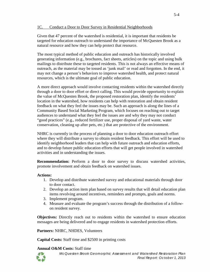
5-4
1C. Conduct a Door to Door Survey in Residential Neighborhoods
Given that 47 percent of the watershed is residential, it is important that residents be targeted for education outreach to understand the importance of McQuesten Brook as a natural resource and how they can help protect that resource.
The most typical method of public education and outreach has historically involved generating information (e.g., brochures, fact sheets, articles) on the topic and using bulk mailings to distribute these to targeted residents. This is not always an effective means of outreach, as the material may be tossed as ‘junk mail’ or read and forgotten. In the end, it may not change a person’s behaviors to improve watershed health, and protect natural resources, which is the ultimate goal of public education.
A more direct approach would involve contacting residents within the watershed directly through a door to door effort or direct calling. This would provide opportunity to explain the value of McQuesten Brook, the proposed restoration plan, identify the residents’ location in the watershed, how residents can help with restoration and obtain resident feedback on what they feel the issues may be. Such an approach is along the lines of a Community Based Social Marketing Program, which focuses on reaching out to target audiences to understand what they feel the issues are and why they may not conduct “good practices” (e.g., reduced fertilizer use, proper disposal of yard waste, water conservation, cleaning up after pets, etc.) that are protective of the environment.
NHRC is currently in the process of planning a door to door education outreach effort where they will distribute a survey to obtain resident feedback. This effort will be used to identify neighborhood leaders that can help with future outreach and education efforts, and to develop future public education efforts that will get people involved in watershed activities and in understanding the issues.
Recommendation: Perform a door to door survey to discuss watershed activities, promote involvement and obtain feedback on watershed issues.
Actions: 1. Develop and distribute watershed survey and educational materials through door
to door contact. 2. Develop an action item plan based on survey results that will detail education plan
items revolving around incentives, reminders and prompts, goals and norms. 3. Implement program. 4. Measure and evaluate the program’s success through the distribution of a follow-
on resident survey.
Objectives: Directly reach out to residents within the watershed to ensure education messages are being delivered and to engage residents in watershed protection efforts.
Partners: NHRC, NHDES, Volunteers
Capital Costs: Staff time and $2500 in printing costs
Annual O&M Costs: Staff time McQuesten Brook Geomorphic Assessment and Watershed Restoration Plan
Final Report: October 1, 2013

5-5
1D. Promote Increased Infrastructure Maintenance
The lower watershed is largely commercial, with large impervious parking lots. Winter road and parking lot maintenance can result in significant applications of sand and salt to make these impervious surfaces safe for travel. Precipitation and snow melt will wash the sand and salt from impervious surfaces into nearby drainage infrastructure and ultimately into the brook. McQuesten Brook fails to meet aquatic life designated uses because of elevated chloride concentrations.
Maintenance practices, such as sweeping and cleaning of catch basins can remove sand, sediment and attached pollutants before it is washed into the brook. The draft National Pollutant Discharge Elimination System (NPDES) Phase II Municipal Separate Storm Sewer System (MS4) permit lays out maintenance requirements for regulated MS4s, including annual street sweeping and cleaning of catch basins to maintain 50 percent sump capacity at all times. However, the MS4 permit does not cover private businesses.
Similar maintenance practices at private parking lots will also help improve the quality of the brook. An outreach program can be used to discuss sand and salt reduction and parking lot maintenance practices that are good for the environment. Commercial property owners that contract for their snow removal, sand and salt applications should be encouraged to hire certified New Hampshire Green SnowPro applicators. They should also require their existing contractors to get the certification offered through the University of New Hampshire (UNH) Technology Transfer Center (http://www.t2.unh.edu/green-snowpro-certification).
Recommendation: Contact business owners throughout the watershed to discuss sand and salt application and good housekeeping practices to limit the amount of sand and salt that discharges into the brook.
Actions: 1. Contact businesses to obtain information on sand and salt usage and current
maintenance practices. Distribute information on sanding impacts and good maintenance practices.
2. Follow-up with businesses annually to determine sand and salt applications and whether maintenance practices have changed.
3. Provide businesses with New Hampshire Green SnowPro training and certification information/opportunities and encourage participation from them and/or their contractors.
Objectives: Contact business owners to increase awareness of the brook and increase drainage infrastructure maintenance on private properties.
Partners: NHRC, City of Manchester, Town of Bedford, Private Businesses
Capital Costs: Staff time
Annual O&M Costs: Staff time
McQuesten Brook Geomorphic Assessment and Watershed Restoration Plan Final Report: October 1, 2013

5-6
1E. Promote Road Salt Reduction Initiative
Water quality data in McQuesten Brook shows elevated concentrations of specific conductance, indicative of pollution from road salt. As a result, McQuesten Brook is included on the draft 2012 303(d) List of Impaired Waters for a chloride impairment. This is associated with salting of parking lots and roadways within the watershed. Contaminants from salt applications on roads and parking lots enter the brook through infiltration to groundwater, runoff to surface water, and through stormdrains. Chloride cannot be treated or filtered with BMPs, so once salt is applied, chloride remains in the watershed until it is flushed downstream. Elevated concentrations can be toxic to aquatic life, including fish, macroinvertebrates, insects, and amphibians.
Due to its persistence, the best methods for reducing salt concentrations rely on management practices to limit its application on impervious surfaces. NHDES has dedicated a portion of its website to the New Hampshire Road Salt Reduction Initiative, which includes information on the impacts of road salt and technologies and BMPs for Salt Reduction (http://des.nh.gov/organization/divisions/water/wmb/was/salt-reduction-initiative/).
The draft NPDES Phase II Municipal Separate Storm Sewer System (MS4) permit has also incorporated requirements for specific regulated communities to develop Salt Reduction Plans for areas that discharge to chloride impaired waters like McQuesten Brook. The Salt Reduction Plan must evaluate salt application and reduction of municipal operations and tracking of salt applications from businesses with more than 10 parking spaces. If included in the final permit, and McQuesten Brook is included on the Final 2012 303(d) List of Impaired Waters, the City of Manchester and Town of Bedford will have to develop a Salt Reduction Plan for discharges to McQuesten Brook.
The first step to salt reduction is outreach. Many businesses may not be aware of the impacts salt has on the environment and/or the options available to reduce salt applications. Development and implementation of a salt reduction strategy can also save businesses and property managers’ operational costs each year.
Recommendation: Contact business owners throughout the watershed to discuss salt application practices and technologies and BMPs for salt reduction. Work with the City of Manchester and Town of Bedford to reach these businesses.
Actions: 1. Contact the City of Manchester and Town of Bedford to discuss their plans for
salt reduction and outreach. 2. Contact businesses to obtain information on salt usage and to present reduction
options. 3. Follow up with businesses annually to determine salt applications have been
reduced. Under the NPDES Phase II Permit, Manchester businesses may eventually be required to report this information to the City of Manchester.
4. Encourage commercial property owners that contract for their snow removal, sand and salt applications to hire certified New Hampshire Green SnowPro applicators.
McQuesten Brook Geomorphic Assessment and Watershed Restoration Plan Final Report: October 1, 2013

5-7
They should also require their existing contractors to get the certification offered through the UNH Technology Transfer Center.
Objectives: Work with municipalities and businesses to reduce salt application and specific conductance/chloride levels in the McQuesten watershed. Note that the salt application initiative may be combined with the sand reduction efforts where it makes sense.
Partners: NHRC, NHDES, City of Manchester, Town of Bedford
Capital Costs: Staff time
Annual O&M Costs: Staff time
McQuesten Brook Geomorphic Assessment and Watershed Restoration Plan Final Report: October 1, 2013

5-8
1F. Install Storm Drain Markers
There are 348 known catch basins or storm drains within the watershed that discharge directly into McQuesten Brook or McQuesten Pond without treatment. These open drainage structures also introduce the potential for illegal dumping of pollutants into the storm drain system.
Storm drain marking can help prevent illegal dumping of pollutants into drains by reminding those passing by that the storm drain connects to a local water body and that dumping will pollute those waters. Storm drains can be labeled with plaques, tiles, painted or pre-cast messages warning citizens not to dump pollutants into the drain. Common messages include: “No Dumping. Drains to Water Source,” and “Drains to River,” and are often accompanied by pictures to convey the message, including common aquatic fauna or a graphic depiction of the path from drain to waterbody.
Recommendation: Mark storm drains within the watershed with messages warning citizens not to dump pollutants into the drain.
Actions: 1. Identify storm drains for marking. 2. Purchase materials (e.g., stencils, paints, markers, etc.) for marking drains. 3. Coordinate volunteers to perform marking. 4. Mark storm drains. 5. Plot marked drain locations on a GIS layer and provide to the Town of Bedford
and City of Manchester so that any re-paving or other public works projects can be informed by the data and arrangements made to re-stencil or re-plate.
Objectives: Increase awareness of connectivity between storm drains and McQuesten Brook to prevent illegal dumping of pollutants into drains.
Partners: NHRC, NHDES, City of Manchester, Town of Bedford, volunteers
Capital Costs: $3,500 for materials (brass plates, adhesive bolts), Staff and volunteer time for installation
Annual O&M Costs: Staff time
McQuesten Brook Geomorphic Assessment and Watershed Restoration Plan Final Report: October 1, 2013

5-9
#2. Stream Corridor Protection The geomorphic assessment described in Section 3.0 was used to delineate a fluvial erosion hazard (FEH) area for McQuesten Brook. Refer to Figure 3-4 and Appendix B for the FEH corridor delineation. The FEH area defines a corridor along the stream which is of sufficient width to accommodate the streams meander geometry, slope and vegetated buffers in its stable form. For unstable areas, it encompasses the area needed for the stream to evolve to, and maintain, a stable form. In the case of an existing stream in reference condition, the FEH corridor includes the stream and floodplain areas which should be left unaltered so that equilibrium conditions are maintained.
Preserving the FEH corridor in an unaltered state, such as via conservation easements, minimizes human/stream conflicts and damage to property and infrastructure while maximizing ecological services such as floodwater attenuation, sediment and nutrient storage, and wildlife habitat.
Recommendation: Protect the FEH corridor through conservation easements. Priority should be given to protecting the following segments in the order listed: 2B, 2D, 2A and 1C (Refer to Figure 3-3).
Actions: 1) Pursue conservation easements for land within the FEH corridor.
Objectives: Acquire conservation easements to preserve portions of stream corridor that maintain and allow future stream stabilization.
Partners: NHRC, City of Manchester, Town of Bedford
Capital Costs: Conservation easement costs vary depending on the current owner, easement size, number of lots affected, value of land, and other factors.
Annual O&M Costs: None
McQuesten Brook Geomorphic Assessment and Watershed Restoration Plan Final Report: October 1, 2013
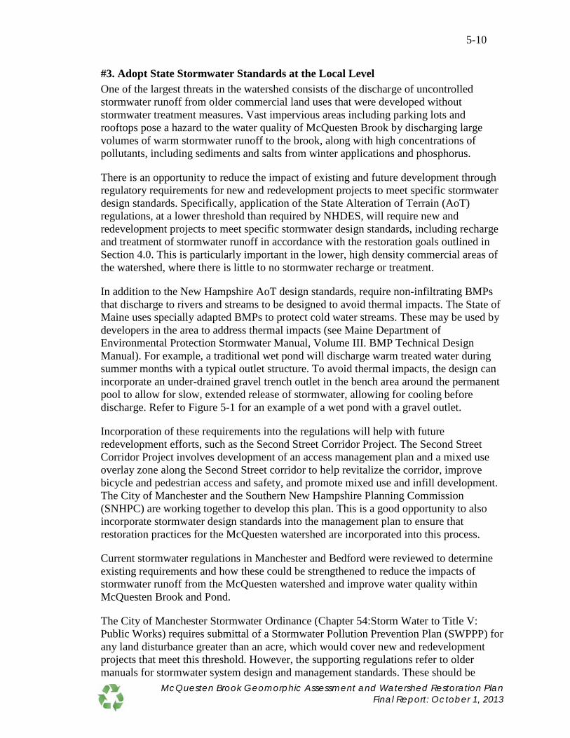
5-10
#3. Adopt State Stormwater Standards at the Local Level One of the largest threats in the watershed consists of the discharge of uncontrolled stormwater runoff from older commercial land uses that were developed without stormwater treatment measures. Vast impervious areas including parking lots and rooftops pose a hazard to the water quality of McQuesten Brook by discharging large volumes of warm stormwater runoff to the brook, along with high concentrations of pollutants, including sediments and salts from winter applications and phosphorus.
There is an opportunity to reduce the impact of existing and future development through regulatory requirements for new and redevelopment projects to meet specific stormwater design standards. Specifically, application of the State Alteration of Terrain (AoT) regulations, at a lower threshold than required by NHDES, will require new and redevelopment projects to meet specific stormwater design standards, including recharge and treatment of stormwater runoff in accordance with the restoration goals outlined in Section 4.0. This is particularly important in the lower, high density commercial areas of the watershed, where there is little to no stormwater recharge or treatment.
In addition to the New Hampshire AoT design standards, require non-infiltrating BMPs that discharge to rivers and streams to be designed to avoid thermal impacts. The State of Maine uses specially adapted BMPs to protect cold water streams. These may be used by developers in the area to address thermal impacts (see Maine Department of Environmental Protection Stormwater Manual, Volume III. BMP Technical Design Manual). For example, a traditional wet pond will discharge warm treated water during summer months with a typical outlet structure. To avoid thermal impacts, the design can incorporate an under-drained gravel trench outlet in the bench area around the permanent pool to allow for slow, extended release of stormwater, allowing for cooling before discharge. Refer to Figure 5-1 for an example of a wet pond with a gravel outlet.
Incorporation of these requirements into the regulations will help with future redevelopment efforts, such as the Second Street Corridor Project. The Second Street Corridor Project involves development of an access management plan and a mixed use overlay zone along the Second Street corridor to help revitalize the corridor, improve bicycle and pedestrian access and safety, and promote mixed use and infill development. The City of Manchester and the Southern New Hampshire Planning Commission (SNHPC) are working together to develop this plan. This is a good opportunity to also incorporate stormwater design standards into the management plan to ensure that restoration practices for the McQuesten watershed are incorporated into this process.
Current stormwater regulations in Manchester and Bedford were reviewed to determine existing requirements and how these could be strengthened to reduce the impacts of stormwater runoff from the McQuesten watershed and improve water quality within McQuesten Brook and Pond.
The City of Manchester Stormwater Ordinance (Chapter 54:Storm Water to Title V: Public Works) requires submittal of a Stormwater Pollution Prevention Plan (SWPPP) for any land disturbance greater than an acre, which would cover new and redevelopment projects that meet this threshold. However, the supporting regulations refer to older manuals for stormwater system design and management standards. These should be
McQuesten Brook Geomorphic Assessment and Watershed Restoration Plan Final Report: October 1, 2013

5-11
Figure 5-1. Wet Pond with Gravel Outlet This wet pond example, taken from the Maine Department of Environmental Protection Stormwater Manual, Volume III. BMP Technical Design Manual, Chapter 4, provides an example of a BMP designed to cool treated stormwater runoff before it is discharged. In this example, an underdrained gravel outlet is built into the pond’s bench. Warm, treated water must flow through the gravel into the perforated underdrain pipe to be discharged.
McQuesten Brook Geomorphic Assessment and Watershed Restoration Plan Final Report: October 1, 2013

5-12
updated to reference the latest State design standards to help meet the restoration goals outlined in Section 4.0.
The Town of Bedford Land Development Control Regulations, Part II – Subdivision Regulations apply to the division of a lot into two or more lots, plats, sites or other division of land and promotes the use of foundation drains for building structures to avoid direct connection to the municipal storm drainage system and requires peak control of the 25-year storm. Part III – Site Plan Regulations requires control of peak rate of discharge for the 25-year and 50-year design storms and submittal of an erosion and sedimentation control plan. Updating these regulations to require compliance with the AoT design standards at a one acre or lower land disturbance threshold will help meet the restoration goals outlined in Section 4.0.
Recommendation: Coordinate with the City of Manchester and Town of Bedford to:
• Encourage adoption of AoT standards from NHDES and to present other ongoing watershed protection efforts and how these may also fit into Phase II Stormwater Management Programs.
• Keep municipal representatives informed of ongoing watershed protection efforts and obtain their input.
Work with the City of Manchester and SNHPC to incorporate watershed restoration efforts into the Second Street Corridor Project.
Actions: 1) Contact and meet with planning boards and public works in Manchester and
Bedford to promote adoption of stormwater design standards into regulations. 2) Present the restoration plan and proposed BMP alternatives for the area to
planning boards and public works so they can incorporate restoration activities into future redevelopment projects as they occur.
3) Follow-up with Manchester and Bedford planning boards and public works at least annually to discuss ongoing projects and potential collaboration.
4) Work with City of Manchester and SNHPC to incorporate the McQuesten watershed restoration efforts into the Second Street Corridor Project.
Objectives: Adopt AoT stormwater design standards at the local level for new and redevelopment projects with a threshold of one acre or less to meet stormwater recharge and treatment restoration goals.
Partners: NHRC, City of Manchester, Town of Bedford
Capital Costs: Staff time
Annual O&M Costs: Staff time
McQuesten Brook Geomorphic Assessment and Watershed Restoration Plan Final Report: October 1, 2013

5-13
#4. Install Stormwater Best Management Practices in Lower Watershed The lower McQuesten watershed is densely developed with commercial businesses. There are 348 known catch basins in the watershed that collect stormwater runoff from the surrounding impervious surfaces and carry it through underground pipes to a stormwater outfall. There are eight stormwater outfalls into McQuesten Brook, between South Main Street and the Merrimack River, and two into McQuesten Pond. These allow untreated stormwater runoff and pollutants to enter the brook and pond.
As part of this study, these areas were screened for potential structural stormwater BMP opportunities. Several alternatives were identified for each of the lower subwatersheds, with an overall goal of increasing stormwater recharge and treating the one inch water quality volume (WQV). BMP alternatives included:
• Infiltration parking dividers – Existing raised vegetated parking dividers can be converted to collect, treat and infiltrate stormwater runoff without losing parking spaces. A recent example can be seen at the retail strip mall located south of the watershed on South River Road.
• Leaching catch basins – Existing catch basins can be retrofitted to incorporate leaching catch basins that infiltrate the smaller, more frequent storms.
• Infiltration basins – Some commercial properties have the space to incorporate a larger infiltration basin without losing parking spaces. These infiltration basins collect, treat, and infiltrate stormwater runoff.
• Bioretention – Bioretention consists of a vegetated filtration area that blends well with the surrounding landscape. The specified soil media provides filtration of pollutants before infiltrating it into the ground. They are typically designed as landscape features.
• Porous asphalt – Existing paved surfaces can be replaced with porous asphalt that allows water to infiltrate into the ground, minimizing warm stormwater runoff that enters the brook.
• Vegetated filter swales – Vegetated filter swales replace paved swales to provide pollutant removal through filtration and promote infiltration.
• Tree filters – Tree filters are landscaped features that collect and filter stormwater runoff before infiltrating it into the ground. Tree filters also provide shady areas in parking lots and road shoulders that reduce runoff temperatures and offer habitat for wildlife.
These alternatives were selected to provide examples of pollutant removal capabilities and associated costs to help direct future BMP designs and were applied to a portion of each site, representing the area that could be treated by BMP alternatives without significantly altering the existing drainage systems or regrading contributing areas. Treatment of a larger site area may be possible at an increased cost or alternatively, could be incorporated into redevelopment efforts as they come up. A combination of stormwater treatment design standards (Recommendation #3) and example BMP alternatives will help achieve the greatest restoration benefit at the lowest cost during redevelopment.
McQuesten Brook Geomorphic Assessment and Watershed Restoration Plan Final Report: October 1, 2013

5-14
In the meantime, NHRC could pursue funding opportunities to implement some of the BMP alternatives within the lower watershed (Subwatersheds 1 through 11) to demonstrate these BMP options while increasing protection of McQuesten Brook. The demonstration BMPs would serve as examples for future redevelopment projects.
Recommendation: Pursue funding to design and install structural stormwater treatment BMPs in the lower watershed. Begin with BMPs in Subwatersheds 1 through 4 and the Hale Street discharge swale in Subwatershed 9 (this swale drains Subwatershed 8). Proposed BMPs for properties along Second Street should be incorporated into the Second Street Corridor Project for implementation when this area is redeveloped.
Actions: 1) Contact property owners in Subwatersheds 1 through 11 to discuss proposed
projects and determine owner interest in participating. This should occur as soon as possible to bring property owners on board.
2) Pursue grant funding opportunities to design and construct stormwater BMPs. 3) Design and construct BMP retrofits for selected properties based on owner
cooperation and available funding.
Objectives: Install structural BMPs to increase groundwater recharge and reduce stormwater runoff from the McQuesten watershed. This will serve to help maintain lower stream temperatures and minimize pollutant contributions, which will in turn reduce the frequency with which low DO levels occur.
Partners: NHRC, NHDES, New Hampshire Fish and Game Department, City of Manchester, Town of Bedford, Private Property Owners
Capital Costs: $535,000
Annual O&M Costs: Assume an allowance of $1,000 per BMP per year for annual maintenance including cleanout and disposal of sediment
McQuesten Brook Geomorphic Assessment and Watershed Restoration Plan Final Report: October 1, 2013

5-15
#5. Culvert Retrofits There are four roadway crossings between the South Main Street culvert where McQuesten Brook emerges and where it outlets into the Merrimack River. From downstream to upstream these are: Interstate 293, Wathen Road, Eastman Avenue, and Second Street. A round culvert carries McQuesten Brook under each of these roads. Each was assessed for its compatibility with the stream geomorphology at the crossing site and the ability to allow aquatic organism passage (AOP).
Based on this assessment, all of the culverts have reduced or no AOP and none are fully compatible with the stream geomorphology, thus improvements at all locations would provide the following benefits to the brook:
1. I-293: Restoring full AOP would reconnect the Merrimack River to the entire length of McQuesten Brook between the interstate and South Main Street (~2,600 feet). This would also reduce the potential for debris jams at the inlet and overtopping and washout of the interstate during an extreme flood. However, before a culvert upgrade is performed, additional study is needed to evaluate how the fish community in McQuesten Brook could be affected .
2. Wathen Road: Restoring full AOP would increase access to about 1,950 feet of the stream between Wathen Road and South Main Street. Increasing hydraulic and sediment transport capacity would reduce the potential for roadway flooding and washout.
3. Eastman Avenue: Restoring full AOP would increase access to about 1,650 feet of the stream between Eastman Avenue and South Main Street. Increasing hydraulic and sediment transport capacity would reduce the potential for roadway flooding and washout.
4. Second Street: Restoring full AOP would increase access to ~900 feet of the stream between Second Street and South Main Street. Increasing hydraulic and sediment transport capacity would reduce the potential for roadway flooding and washout.
Recommendation: Replace or retrofit undersized culverts to promote compatibility with the stream geomorphology and AOP. The following improvements should be made in order of preference:
1) I-293: Perform a study to evaluate whether better connectivity between McQuesten Brook and the Merrimack River could impact the fish community and specifically, the eastern native brook trout population. If the study reveals that the replacement of the culvert is beneficial to the quality of McQuesten Brook and its habitat, then replace existing culvert with larger structure designed to provide full AOP and reduce debris jams at inlet. Approximate dimensions for a new culvert would depend on whether it is designed to meet the New Hampshire Stream Crossing Guidelines or whether it can be permitted as an alternative design under the stream crossing rules to meet bankfull channel width. The approximate dimensions are:
• New Hampshire Stream Crossing Guidelines – 17 foot span x 6 foot rise x 210 foot long precast concrete box culvert
McQuesten Brook Geomorphic Assessment and Watershed Restoration Plan Final Report: October 1, 2013

5-16
• Bankfull Channel Width – 12 foot span x 6 foot rise x 210 foot long precast concrete box culvert
This would require the cooperation of the New Hampshire Department of Transportation (NHDOT) and is not likely to occur until the highway is redeveloped at some point in the future. Until that time, the culvert can be retrofitted with baffles or weirs and construction of a step-pool channel immediately below the culvert outlet to eliminate outlet drop and restore aquatic organism access to the culvert.
2) Wathen Road: Replace existing culvert with a larger structure designed to provide full AOP and greater hydraulic and sediment transport capacity. Approximate dimensions for a new culvert would depend on whether it is designed to meet the New Hampshire Stream Crossing Guidelines or whether it can be permitted as an alternative design under the stream crossing rules to meet bankfull channel width. The approximate dimensions are:
• New Hampshire Stream Crossing Guidelines – 24 foot span x 10 foot rise x 40 foot long precast concrete open bottom culvert
• Bankfull Channel Width – 12 foot span x 6 foot rise x 40 foot long precast open bottom culvert.
3) Eastman Avenue: Replace existing culvert with a larger structure designed to
provide full AOP and greater hydraulic and sediment transport capacity. Approximate dimensions for a new culvert would depend on whether it is designed to meet the New Hampshire Stream Crossing Guidelines or whether it can be permitted as an alternative design under the stream crossing rules to meet bankfull channel width. The approximate dimensions are:
• New Hampshire Stream Crossing Guidelines – 24 foot span x 10 foot rise x 40 foot long precast concrete open bottom culvert
• Bankfull Channel Width – 12 foot span x 6 foot rise x 40 foot long precast open bottom culvert.
4) Second Street: Replace existing culvert with a larger structure designed to provide
full AOP and greater hydraulic and sediment transport capacity.
Actions: 1) Contact NHDOT, Town of Bedford and City of Manchester to discuss the need
for culvert improvement and the design goals to restore full AOP. Discuss future plans for roadway improvements for possible coordination with culvert improvement work. NHDOT was contacted by NHDES to discuss the replacement of the I-293 culvert. NHDOT does not have foreseeable plans to replace the culvert at this location. The Town of Bedford was also contacted to discuss the replacement of
McQuesten Brook Geomorphic Assessment and Watershed Restoration Plan Final Report: October 1, 2013

5-17
culverts at Wathen Road and Eastman Avenue and has indicated they are planning to replace these two culverts as part of their South River Road Tax Increment Financing (TIF) Project.
2) Evaluate and pursue potential funding sources for culvert improvements. Additional funds may be needed to supplement the Town of Bedford’s budget for culvert replacement at Wathen Road and Eastman Avenue to incorporate design components that fully restore AOP.
3) Design and permit culvert improvements/replacements and include BMPs to treat stormwater runoff entering the brook from the roadway at culvert crossings.
4) Construct culvert improvements/replace culverts.
Objectives: Retrofit culverts to restore full AOP and culvert compatibility with stream geomorphology to improve stream connectivity and increase hydraulic and sediment transport capacity. Simultaneously reduce the potential for roadway flooding and washout.
Partners: NHRC, NHDES, New Hampshire Fish and Game Department, Town of Bedford, City of Manchester, NHDOT
Capital Costs:
1. I-293: $1,025,000 for design, permitting and construction of a culvert that meets New Hampshire Stream Crossing Guidelines minimum span requirements.
2. Wathen Road and Eastman Avenue: $650,000 plus engineering, paving, moving sewer, and other associated costs
3. Second Street: $750,000-$900,000
Annual O&M Costs: None
McQuesten Brook Geomorphic Assessment and Watershed Restoration Plan Final Report: October 1, 2013

5-18
#6. Dam Removal There are three stream barriers located in the McQuesten watershed, including: McQuesten Pond Dam #1 (McPD1), McQuesten Pond Dam #2 (McPD2), and South Main Street Dam (SMSD) as shown in Figure 4-15.
The SMSD is located on a freely flowing section of McQuesten Brook immediately downstream of the 66 inch culvert under South Main Street. The McPD1 and McPD2 have impounded a branch of McQuesten Brook to create McQuesten Pond. The pond averages 18 inches deep and is an impaired water for failure to support aquatic life due to insufficient dissolved oxygen and excessive algal concentrations. Due to its shallow depths, McQuesten Pond quickly warms in summer months contributing thermal impacts to McQuesten Brook.
The SMSD contributes to the erosion of the left streambank adjacent to the structure, as stream flows seek an alternate route around the structure. Dead Eastern Brook Trout have also been discovered on the upstream end of the dam, having suffocated after being trapped in a debris jam of tires, litter, and yard waste at the failed culvert that passes through the concrete dam structure. Removal of this structure would help restore stream planform and remove the threat of the dam to fish passage.
Removal of two McQuesten Pond dams will eliminate thermal impacts to the downstream brook environment and return this branch of McQuesten Brook to a single thread channel with lush riparian cover and buffers. Flooding impacts to adjacent properties will also be reduced.
Recommendation: Remove dams along McQuesten Brook, including McQuesten Pond Dam #1 (McPD1), McQuesten Pond Dam #2 (McPD2), and South Main Street Dam (SMSD).
Actions: 1) Pursue funding for dam removal. NHRC has secured funding through NHDES
and the City of Manchester for McPD1, McPD2, and SMSD. 2) Contract with consultant engineer to implement the design, engineering and
permitting for dam removal. 3) Prepare a sediment analysis, management and mitigation study and hydraulic and
hydrologic modeling to measure the pre and post-dam removal conditions. 4) Prepare final dam removal designs and secure permits. 5) Remove dams. 6) Conduct pre and post monitoring to assess biological, physical and chemical
improvements.
Objectives: Remove dams to restore natural stream channel, reduce streambank erosion, alleviate flooding, and reduce thermal impacts to McQuesten Brook.
Partners: NHRC, NHDES, City of Manchester, Town of Bedford, New Hampshire Fish and Game Department, River Network, Consultant, Volunteers
McQuesten Brook Geomorphic Assessment and Watershed Restoration Plan Final Report: October 1, 2013

5-19
Capital Costs: $110,000 for engineering/design services, with removal of dams performed by the City of Manchester in-kind
Annual O&M Costs: None
McQuesten Brook Geomorphic Assessment and Watershed Restoration Plan Final Report: October 1, 2013

5-20
#7. Streambank Restoration The geomorphic assessment in Section 3.0 identified three areas that could benefit with additional plantings along the bank. These included:
1. Left Bank in Segment M02C (Subwatershed 9) – The commercial parking area along this bank extends nearly to the brook’s edge, providing no buffer for stormwater runoff. Increased buffer, vegetation cover and density will reduce bank erosion potential and provide some filtration of parking lot runoff (this was also recommended as BMP Alternative 9-1 in Table 4-6).
2. Right Bank in Segment M02A (Subwatershed 3) – Some erosion was identified along the right bank and valley wall, approximately 18 feet long x 18 feet high. Increased vegetation cover and density will reduce the potential for additional bank erosion and mass wasting of the upper slope/valley wall (this was also recommended as BMP Alternative 3-2 in Table 4-6).
3. Right Bank in Segment M01B (Subwatershed 3) – Some erosion was identified along the right bank and valley wall, approximately 34 feet long x 18 feet high. Increased vegetation cover and density will reduce the potential for additional bank erosion and mass wasting of the upper slope/valley wall (this was also recommended as BMP Alternative 3-2 in Table 4-6).
Recommendation: Stabilize and vegetate eroded banks as follows:
1. Left Bank in Segment M02C (Subwatershed 9) – Increase buffer and plant face of the left bank along the parking lot and small strip of land between top of bank and edge of pavement with live stakes, tubelings, or containerized shrubs. Also establish perennial ground cover between top of bank and pavement. Willow and dogwood live stakes or tubelings would be best suited to the bank face. Containerized alders are recommended for the area between the top of bank and edge of pavement.
2. Right Bank in Segment M02A (Subwatershed 3) – Stabilize bank slopes with geofabric and plantings. Install plantings along eroding right bank and on eroded slope at mass wasting site. Willow and dogwood live stakes and/or live fascines are recommended on and adjacent to the bank and at the toe of eroded slope. Containerized trees and shrubs are recommended on the slope. Perennial ground cover should also be established on the upper slope.
3. Right Bank in Segment M01B (Subwatershed 3) – Stabilize bank slopes with geofabric and plantings. Install plantings along toe of bank and on eroded slope at mass wasting site. Willow and dogwood live stakes are recommended at the toe of the slope/bank as these can be installed within the existing riprap voids. Containerized trees and shrubs are recommended on the slope. Perennial ground cover should also be established on the upper slope.
Actions: 1) Contact property owners to obtain permission to construct improvements. 2) Seek funding for design and construction. 3) Design and permit bank stabilization and erosion controls. 4) Install bank stabilization and erosion controls. 5) Incorporate improvements into the education outreach program. McQuesten Brook Geomorphic Assessment and Watershed Restoration Plan
Final Report: October 1, 2013

5-21
Objectives: Increase vegetated buffer along the brook to increase filtration of overland stormwater runoff, provide shading of brook segments and prevent further erosion of banks into the brook.
Partners: NHRC, NHDES, City of Manchester, Town of Bedford, Private Business Owners, Volunteers
Capital Costs: $11,000
Annual O&M Costs: None
McQuesten Brook Geomorphic Assessment and Watershed Restoration Plan Final Report: October 1, 2013

5-22
#8. Long-term Monitoring Program A long-term monitoring program is recommended to document environmental/watershed trends and evaluate the effect of watershed improvements on water quality, with a focus on water temperatures and dissolved oxygen. Water temperature trends compared with air temperatures and the amount of precipitation can be used to assess whether the restoration program is reducing brook temperatures, with channel stability and fish habitat surveys used to assess the effect of any in-stream improvements.
With the proposed removal of the McQuesten Pond dams, it may be possible to shift volunteer monitors to collecting data from McQuesten Brook.
Recommendation:
1. Continue the current New Hampshire Fish and Game Department monitoring program, which includes continuous monitoring of water temperatures below Wathen Road, Second Street and South Main Street throughout July and August of each year. Consider purchasing additional data loggers to collect DO and specific conductance data over this same period, providing another set of trends to assess brook improvements. One data logger could be purchased and moved between locations over the course of the July-August period.
2. For any in-stream restoration projects that are undertaken, incorporate into them a monitoring component that includes both fish species and habitat monitoring as well as physical monitoring (e.g. cross-section and profile surveys) to determine their effects on stream biology and geomorphology.
3. Continue to implement the VRAP activities within the watershed currently conducted by volunteers from the Manchester Urban Ponds Restoration Program with assistance provided by NHDES staff and funding provided by the City of Manchester (and seek financial support from the Town of Bedford. Monitoring stations can be added and sampling frequency increased to support specific plan objectives.
Actions: 1) Work with New Hampshire Fish and Game Department to continue the annual
July-August monitoring program for temperature. 2) Purchase data loggers to measure DO and specific conductance at the same
locations. 3) Adopt ongoing Volunteer River Assessment Program for each instream project
performed on the brook (e.g., streambank restoration, dam removal, culvert replacement) and include fish habitat surveys and evaluation of post-construction channel.
4) Use the data to develop water quality trend lines, noting when elements of the restoration plan are implemented to assess success of the program on the overall quality of McQuesten Brook.
Objectives: Establish long-term environmental trends in the brook to help determine the success of the Watershed Restoration Plan.
McQuesten Brook Geomorphic Assessment and Watershed Restoration Plan Final Report: October 1, 2013

5-23
Partners: NHRC, NHDES, New Hampshire Fish and Game Department, City of Manchester Urban Ponds Restoration Program, Volunteers
Capital Costs: $6,300 to purchase DO and specific conductance data loggers for three locations. It is assumed that the data loggers will be deployed and data collected with temperature data loggers by New Hampshire Fish and Game Department or by volunteers.
Annual O&M Costs: Volunteer time to deploy and down load data from data loggers, calibration and maintenance of data loggers
McQuesten Brook Geomorphic Assessment and Watershed Restoration Plan Final Report: October 1, 2013

5-24
#9. Encourage Stormwater Utility Stormwater utilities are similar in concept to Water and Wastewater Enterprise funds. Under a stormwater utility, properties are assessed a fee, usually based on the amount of impervious surface they have. The fees are dedicated to stormwater improvements and operations and maintenance activities such as catch basin cleaning, street sweeping, maintenance of stormwater BMPs, etc.
In most communities, funds for these programs are quite limited and must come from general DPW or highway budgets, which compete with other departments (e.g., police and fire services) for funding from the general fund.
Most stormwater utilities offer an abatement procedure that allows those who do not generate stormwater, or who implement stormwater practices, to reduce their fees substantially. This provides businesses and residents with an incentive to reduce their stormwater impacts.
The City of Manchester recently evaluated the development of a stormwater utility, including the development of fees for residents and businesses within the City. However, the stormwater utility has not been implemented at this time. This may be implemented in the future, considering the requirements of the draft NPDES MS4 permit and associated cost for compliance. Once implemented, this may provide an incentive for businesses and residents within the McQuesten watershed to implement stormwater BMPs to reduce their stormwater fees.
Recommendation: Keep abreast of the City of Manchester’s progress on its stormwater utility and incorporate incentives into future outreach activities with businesses. Encourage the Town of Bedford to develop a stormwater utility, with similar incentives.
Actions: 1) Continue working with the City of Manchester on the restoration of McQuesten
Brook and its watershed and stay current with Manchester’s progress with establishing a stormwater utility.
2) Encourage the Town of Bedford to establish a stormwater utility. Ask Manchester to share its experiences with Bedford.
Objectives: Provide an incentive for businesses and residents to implement and construct stormwater BMPs, such as saving on stormwater fees when a stormwater utility is implemented.
Partners: NHRC, City of Manchester, Town of Bedford
Capital Costs: Staff time for NHRC. $100,000 - $200,000 to evaluate, develop and implement a stormwater utility.
Annual O&M Costs: Staff time for NHRC to coordinate with City of Manchester and Town of Bedford.
McQuesten Brook Geomorphic Assessment and Watershed Restoration Plan Final Report: October 1, 2013
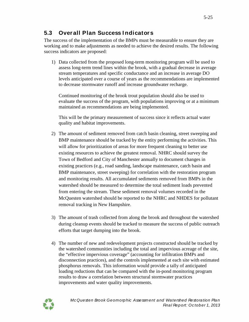
5-25
5.3 Overall Plan Success I ndicators The success of the implementation of the BMPs must be measurable to ensure they are working and to make adjustments as needed to achieve the desired results. The following success indicators are proposed:
1) Data collected from the proposed long-term monitoring program will be used to assess long-term trend lines within the brook, with a gradual decrease in average stream temperatures and specific conductance and an increase in average DO levels anticipated over a course of years as the recommendations are implemented to decrease stormwater runoff and increase groundwater recharge. Continued monitoring of the brook trout population should also be used to evaluate the success of the program, with populations improving or at a minimum maintained as recommendations are being implemented.
This will be the primary measurement of success since it reflects actual water quality and habitat improvements.
2) The amount of sediment removed from catch basin cleaning, street sweeping and BMP maintenance should be tracked by the entity performing the activities. This will allow for prioritization of areas for more frequent cleaning to better use existing resources to achieve the greatest removal. NHRC should survey the Town of Bedford and City of Manchester annually to document changes in existing practices (e.g., road sanding, landscape maintenance, catch basin and BMP maintenance, street sweeping) for correlation with the restoration program and monitoring results. All accumulated sediments removed from BMPs in the watershed should be measured to determine the total sediment loads prevented from entering the stream. These sediment removal volumes recorded in the McQuesten watershed should be reported to the NHRC and NHDES for pollutant removal tracking in New Hampshire.
3) The amount of trash collected from along the brook and throughout the watershed during cleanup events should be tracked to measure the success of public outreach efforts that target dumping into the brook.
4) The number of new and redevelopment projects constructed should be tracked by
the watershed communities including the total and impervious acreage of the site, the “effective impervious coverage” (accounting for infiltration BMPs and disconnection practices), and the controls implemented at each site with estimated phosphorus removals. This information would provide a tally of anticipated loading reductions that can be compared with the in-pond monitoring program results to draw a correlation between structural stormwater practices improvements and water quality improvements.
McQuesten Brook Geomorphic Assessment and Watershed Restoration Plan Final Report: October 1, 2013

5-26
5) Track and document all management actions performed by NHRC and others over the 10-year implementation period to allow correlation with noted water quality changes.
6) Track reductions in directly connected impervious area and strive to get under 10
percent in the watershed.
7) The volume of water is directed in the ground via newly installed Best Management Practices should be tracked in support of the recommended actions found in Table 4.3, Groundwater Recharge.
McQuesten Brook Geomorphic Assessment and Watershed Restoration Plan Final Report: October 1, 2013
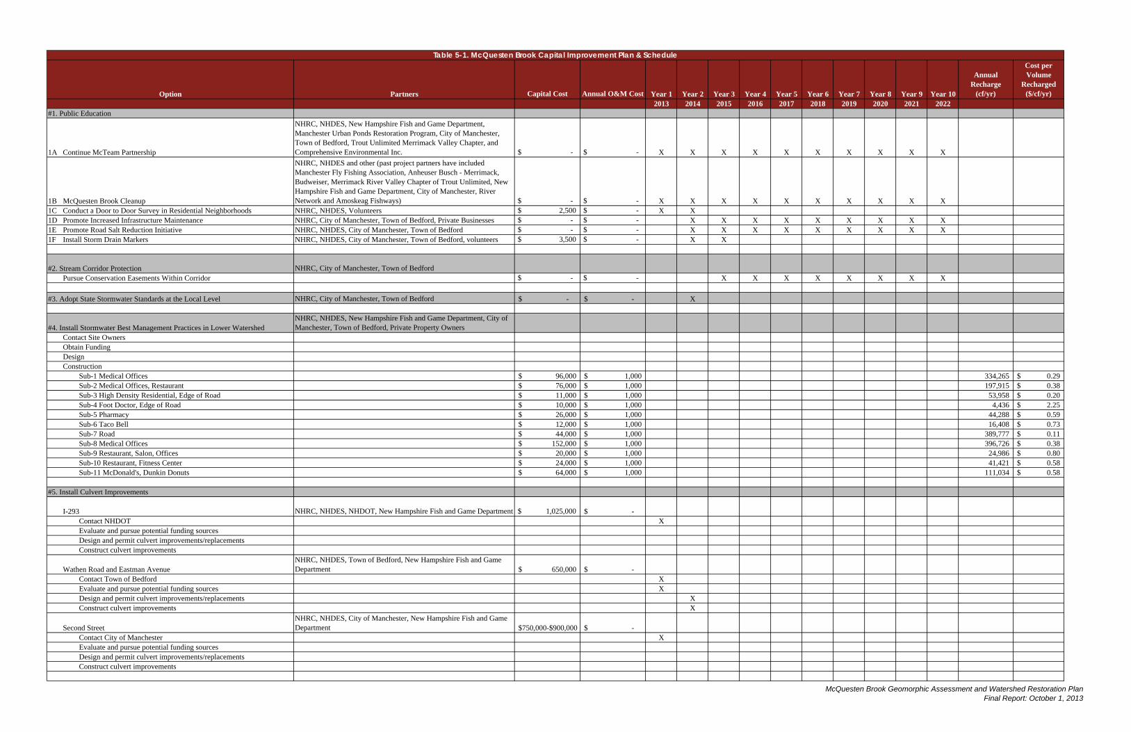
Partners Capital Cost Annual O&M Cost Year 1 Year 2 Year 3 Year 4 Year 5 Year 6 Year 7 Year 8 Year 9 Year 10
Annual Recharge
(cf/yr)
Cost per Volume
Recharged ($/cf/yr)
2013 2014 2015 2016 2017 2018 2019 2020 2021 2022#1. Public Education
1A Continue McTeam Partnership
NHRC, NHDES, New Hampshire Fish and Game Department, Manchester Urban Ponds Restoration Program, City of Manchester, Town of Bedford, Trout Unlimited Merrimack Valley Chapter, and Comprehensive Environmental Inc. $ - $ - X X X X X X X X X X
1B McQuesten Brook Cleanup
NHRC, NHDES and other (past project partners have included Manchester Fly Fishing Association, Anheuser Busch - Merrimack, Budweiser, Merrimack River Valley Chapter of Trout Unlimited, New Hampshire Fish and Game Department, City of Manchester, River Network and Amoskeag Fishways) $ - $ - X X X X X X X X X X
1C Conduct a Door to Door Survey in Residential Neighborhoods NHRC, NHDES, Volunteers $ 2,500 $ - X X1D Promote Increased Infrastructure Maintenance NHRC, City of Manchester, Town of Bedford, Private Businesses $ - $ - X X X X X X X X X1E Promote Road Salt Reduction Initiative NHRC, NHDES, City of Manchester, Town of Bedford $ - $ - X X X X X X X X X1F Install Storm Drain Markers NHRC, NHDES, City of Manchester, Town of Bedford, volunteers $ 3,500 $ - X X
#2. Stream Corridor Protection NHRC, City of Manchester, Town of BedfordPursue Conservation Easements Within Corridor $ - $ - X X X X X X X X
#3. Adopt State Stormwater Standards at the Local Level NHRC, City of Manchester, Town of Bedford -$ -$ X
#4. Install Stormwater Best Management Practices in Lower WatershedNHRC, NHDES, New Hampshire Fish and Game Department, City of Manchester, Town of Bedford, Private Property Owners
Contact Site OwnersObtain FundingDesignConstruction
Sub-1 Medical Offices 96,000$ 1,000$ 334,265 0.29$ Sub-2 Medical Offices, Restaurant 76,000$ 1,000$ 197,915 0.38$ Sub-3 High Density Residential, Edge of Road 11,000$ 1,000$ 53,958 0.20$ Sub-4 Foot Doctor, Edge of Road 10,000$ 1,000$ 4,436 2.25$ Sub-5 Pharmacy 26,000$ 1,000$ 44,288 0.59$ Sub-6 Taco Bell 12,000$ 1,000$ 16,408 0.73$ Sub-7 Road 44,000$ 1,000$ 389,777 0.11$ Sub-8 Medical Offices 152,000$ 1,000$ 396,726 0.38$ Sub-9 Restaurant, Salon, Offices 20,000$ 1,000$ 24,986 0.80$ Sub-10 Restaurant, Fitness Center 24,000$ 1,000$ 41,421 0.58$ Sub-11 McDonald's, Dunkin Donuts 64,000$ 1,000$ 111,034 0.58$
#5. Install Culvert Improvements
I-293 NHRC, NHDES, NHDOT, New Hampshire Fish and Game Department $ 1,025,000 -$ Contact NHDOT XEvaluate and pursue potential funding sourcesDesign and permit culvert improvements/replacementsConstruct culvert improvements
Wathen Road and Eastman AvenueNHRC, NHDES, Town of Bedford, New Hampshire Fish and Game Department 650,000$ -$
Contact Town of Bedford XEvaluate and pursue potential funding sources XDesign and permit culvert improvements/replacements XConstruct culvert improvements X
Second StreetNHRC, NHDES, City of Manchester, New Hampshire Fish and Game Department $750,000-$900,000 -$
Contact City of Manchester XEvaluate and pursue potential funding sourcesDesign and permit culvert improvements/replacementsConstruct culvert improvements
Table 5-1. McQuesten Brook Capital Improvement Plan & Schedule
Option
McQuesten Brook Geomorphic Assessment and Watershed Restoration Plan Final Report: October 1, 2013

Partners Capital Cost Annual O&M Cost Year 1 Year 2 Year 3 Year 4 Year 5 Year 6 Year 7 Year 8 Year 9 Year 10
Annual Recharge
(cf/yr)
Cost per Volume
Recharged ($/cf/yr)
2013 2014 2015 2016 2017 2018 2019 2020 2021 2022
Table 5-1. McQuesten Brook Capital Improvement Plan & Schedule
Option
NHRC, NHDES, City of Manchester, Town of Bedford, New Hampshire Fish and Game Department, River Network, Consultant, Volunteers $110,000 -$
Obtain Funding XContract with Consultant Engineer XPrepare Sediment Analysis and Hydraulic Modeling X
XRemove Dams XConduct Pre and Post Monitoring X X X X X X
#7. Streambank RestorationNHRC, NHDES, City of Manchester, Town of Bedford, Private Business Owners, Volunteers
Left Bank in Segment M02C 5,500$ -$ Contact Property Owners XSeek Funding for Design and Construction XDesign, Permit and Construct Bank Stabilization and Erosion Controls X XIncorporate Improvements in Education Outreach X
Right Bank in Segment M02A 1,925$ -$ Contact Property Owners XSeek Funding for Design and Construction XDesign, Permit and Construct Bank Stabilization and Erosion Controls X XIncorporate Improvements in Education Outreach X
Right Bank in Segment M01B 3,575$ -$ Contact Property Owners XSeek Funding for Design and Construction XDesign, Permit and Construct Bank Stabilization and Erosion Controls X XIncorporate Improvements in Education Outreach X
#8. Long-Term Monitoring ProgramNHRC, NHDES, New Hampshire Fish and Game Department, City of Manchester Urban Ponds Restoration Program, Volunteers
6,300$ X
#9. Encourage Stormwater Utility NHRC, City of Manchester, Town of Bedford -$ X X
Total $3,093,300-$3,243,300 1,615,213
Recharge Goal 13,774,013 Notes:1. Public education activities will be developed in consultation with the McQuesten Brook stakeholders committee.
4. The cost to replace the culverts at Wathen and Eastman Avenue include survey and engineering, permitting, construction and construction services. The Town of Bedford has included replacement of these culverts in its South River Road TIF project.5. The streambank restoration work in segment M02A and M01B should be combined with other projects or performed by volunteers to reduce costs.
3. The cost to replace the undersized culver at I-293 assumes replacement with a 17' span x 6' rise x 210' long precast concrete box culvert with bed retention sills and stream simulation. The 17' span would meet the NH Stream Crossing Guidelines minimum span for the stream type. Costs include engineering, permitting and construction. A 12' span x 6' rise x 210' long precast concrete box culvert with bed retention sills and stream simulation to match bankfull channel width is estimated to cost $803,000.
2. For budgeting purposes, costs included under the "Design and Construct BMPs" recommendation are conceptual level and include design, permitting and construction for the highest cost alternative presented in Table 4-6 (with the exception of Sub-11, which uses the second highest priced alternative).
#6. Dam Removal - Remove Dams McPD1, McPD2 and SMSD Along McQuesten Brook and Pond
Prepare Final Dam Removal Designs and Secure Permits
Purchase Data Loggers - 3 DO, 3 conductivity, software & communications
McQuesten Brook Geomorphic Assessment and Watershed Restoration Plan Final Report: October 1, 2013

Appendix A SSPP

SITE SPECIFIC PROJECT PLAN FOR:
l\kQucsten Brook Gcomorphic Assessment·, Enginet~ring, and Watershed Restoration Plan.
Operated Under: Generic QAPP for Stream Morphology Data Collection
RFA#03285 (August 5, 2008)
and New Hampshire Section 319 Nonpoint Source Grant Program QAPP
RFA#08262
Project Manager/()rantee:
(October 17, 2008)
Final Dran May 2, 2012
Prepared l~v: Comprehensive Environmental Inc.
21 I>epot Street l\<lerrimack, NH 03054
and FB Environmental Associates 97 A Exchange St, Suite 305
Portland MK 04101
S.t4. \J---s· YJ1ature/Datc
Michele L. Tremblay, New Hampshire ivers Council
Project Manager:
Project Engineer for Gcomorphic Assessment: c () ,,-· ~J_ ,--· ··- . ' '· ,. :5 ' I I L ._.,._) I 1, . ·-1--4···-.. ·- ~ . --------...,~· ( Signature/Date
Sean P. Sweeney, Headwaters Hydrology
Site Specific Project Plan for l of 15 5/2112 McQm~-~t.en Brook Geomorphic Asse~smcnt, Engineering, and Watershed Ri!storafion Plan

Project Engineer/Project QA Officer:
NHDES Project Manager:
Program Quality Assurance Coordinator:
NHDES Quality Assurance Manager:
For Receipt:
US EPA Project Manager:
~~st/oh Signatiire/Date
~ Ben Lundsted, CEI
~5/1/12. Sireioate
Steve Landry, NHDES
ature/Datc Jillian Mc hy, NHDES
~~~/i+/; :>--Sigllaure/Date
Vincent Perelli, NHDES
v ~ 5/17/201z_ ' Signature/Date
Erik Beck, US EPA Region I
Site Specific Project Plan for 2of15 5/2/12 McQuesten Brook Geomorphic Assessment, Engineering, and Watershed Restoration Plan

2-Table of Contents 1-Title Page 2-Table of Contents............................................................................................................. 3 List of Tables ...................................................................................................................... 3 List of Figures ..................................................................................................................... 3 3- Distribution List .............................................................................................................. 4 4- Project Organization ....................................................................................................... 5 5-Site Information ............................................................................................................... 7 6-Project Rationale.............................................................................................................. 9 7-Project Description and Schedule .................................................................................... 9 8- Historical Data Information .......................................................................................... 10 9-Establishing Water Quality Goals ..................................................................................11 10-Loading Models ............................................................................................................12 11-Quality Objectives and Criteria ....................................................................................12 12-Quality Control .............................................................................................................13 13-Data Evaluation ............................................................................................................14 14-Final Products and Reporting ...................................................................................... 15
List of Tables Table 1. SSPP Distribution List .......................................................................................... 4 Table 2. Personnel Responsibilities and Qualifications ...................................................... 6
List of Figures Figure 1. Project Organizational Chart. .............................................................................. 5 Figure 2. McQuesten Brook Aerial Photo and Geomorphic Assessment Sample Locations ...............................................................................................................8
Site Specific Project Plan for 5/2/12 McQuesten Brook Geomorphic Assessment, Engineering, and Watershed Restoration Plan
3 of 15

3- Distribution List
Table 1 lists the individuals who will receive copies of the approved Site Specific Project Plan (SSPP) under the Generic Quality Assurance Project Plan for Stream Morphology Data Collection (August 5, 2008) and the New Hampshire Section 319 Nonpoint Source Grant Program QAPP (October 17, 2008). Table 1. SSPP Distribution List
SSPP Recipient
Name Project Role Organization Telephone number and
e-mail address
Michele L. Tremblay
President and Project Manager
New Hampshire Rivers Council
603-228-6472 [email protected]
Rebecca Balke Project Manager Comprehensive Environmental Inc.
800-725-2550, x308 [email protected]
Sean Sweeney Project Engineer Headwaters Hydrology, PLLC 603-444-2544 [email protected]
John Field Technical Advisor for Geomorphic Assessment
Field Geology Services 207-491-9541 [email protected]
Forrest Bell Technical Advisor FB Environmental 207-221-6699 [email protected]
Steve Landry NH DES Project Manager
NHDES, Watershed Management Bureau
603-271-2969 [email protected]
Jillian McCarthy
Program QA Coordinator
NHDES, Watershed Management Bureau
603-271-8475 jillian,[email protected]
Vince Perelli NHDES QA Manager
NHDES, Planning, Prevention, & Assistance Unit
603-271-8989 [email protected]
Shane Csiki Technical Advisor on Geomorphic Assessment
NH Geological Survey 603-271-2876 [email protected]
Erik Beck USEPA Project Manager USEPA New England 617-918-1606
[email protected] Eileen Pannetier
Program Manager, Technical Review
Comprehensive Environmental Inc.
[email protected] 800-725-2550
Ben Lundsted Project Engineer/ QA Officer
Comprehensive Environmental Inc.
[email protected] 800-725-2550 x317
Curt Busto Technical Assistant/GIS
Comprehensive Environmental Inc.
[email protected] 800-725-2550
Site Specific Project Plan for 5/2/12 McQuesten Brook Geomorphic Assessment, Engineering, and Watershed Restoration Plan
4 of 15
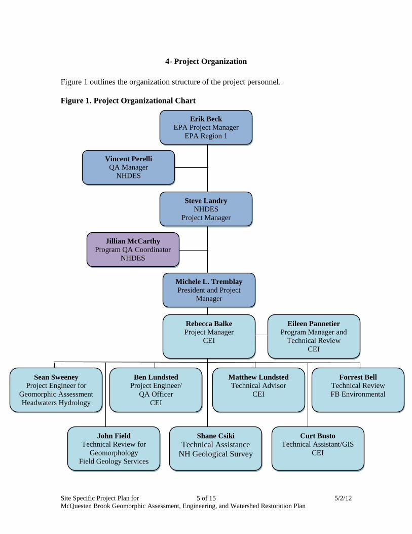
4- Project Organization Figure 1 outlines the organization structure of the project personnel. Figure 1. Project Organizational Chart
Erik Beck EPA Project Manager
EPA Region 1
Vincent Perelli QA Manager
NHDES
Steve Landry NHDES
Project Manager
Michele L. Tremblay President and Project
Manager
Jillian McCarthy Program QA Coordinator
NHDES
Eileen Pannetier Program Manager and
Technical Review CEI
Rebecca Balke Project Manager
CEI
Curt Busto Technical Assistant/GIS
CEI
Shane Csiki Technical Assistance
NH Geological Survey
John Field Technical Review for
Geomorphology Field Geology Services
Forrest Bell Technical Review FB Environmental
Matthew Lundsted Technical Advisor
CEI
Sean Sweeney Project Engineer for
Geomorphic Assessment Headwaters Hydrology
Ben Lundsted Project Engineer/
QA Officer CEI
Site Specific Project Plan for 5/2/12 McQuesten Brook Geomorphic Assessment, Engineering, and Watershed Restoration Plan
5 of 15

Table 2 identifies the roles and responsibilities of those individuals involved in the project. Table 2. Personnel Responsibilities and Qualifications
Name and Affiliation Responsibilities Qualifications Michele L. Tremblay, NH Rivers Council
President and Project Manager Grantee
Eileen Pannetier, Comprehensive Environmental Inc.
Program Manager and Technical Review
Trained in watershed management and restoration; experienced program director
Rebecca Balke, Comprehensive Environmental Inc.
Project Manager
Registered NH Professional Engineer trained in watershed pollutant modeling and restoration; experienced project manager
Ben Lundsted, Comprehensive Environmental Inc.
Project Engineer, Project QA Officer
Registered NH Professional Engineer trained in field investigation and data collection and BMP design
Sean Sweeney, Headwaters Hydrology, PLLC
Project Engineer for Geomorphic Assessment
P.E., CWS; author of Generic QAPP for Stream Morphology Data Collection; trained in stream morphology data collection, analysis, interpretation, and stream survey techniques
John Field, Field Geology Services
Technical Review for Geomorphic Assessment
Ph.D.; trained in stream morphology data collection, analysis, interpretation, and stream survey techniques
Matthew Lundsted, Comprehensive Environmental Inc.
Technical Advisor P.E.
Forrest Bell, FB Environmental
Technical Review of Plan On file at FB Environmental
Curt Busto, Comprehensive Environmental Inc.
GIS Mapping Trained in GIS mapping, data collection and field assessment
Jillian McCarthy, NHDES, Watershed Management Bureau
Reviews QAPP preparation and other QA/QC activities On file at NHDES
Steve Landry, NHDES, Watershed Management Bureau
Reviews and oversees projects funded by DES 319 Restoration Grants in Merrimack basin.
On file at NHDES
Vince Perelli, NHDES Planning, Prevention & Assistance Unit Reviews and approves QAPPs On file at NHDES
Shane Csiki NH Geological Survey Technical Advisor On file at NHGS
Erik Beck, US EPA Region I EPA Project Manager On file at US EPA
Site Specific Project Plan for 5/2/12 McQuesten Brook Geomorphic Assessment, Engineering, and Watershed Restoration Plan
6 of 15

5-Site Information This project will be undertaken on McQuesten Brook in Manchester, NH (Figure 2). The McQuesten Brook headwaters emerge from a culvert under South Main Street in Manchester, merge with the outlet of McQuesten Pond before flowing under Second Street, Eastman Avenue, Wathen Road, and I-293 before reaching the Merrimack River. The stream watershed is approximately 627 acres. McQuesten Brook from the discharge pipe outlet at South Main Street to the Merrimack River is approximately 2,800 feet long. During initial field investigations and watershed delineation, it was discovered that an unnamed tributary that once fed Bowman Brook is now piped to the South Main Street discharge, enlarging the watershed. The unnamed tributary starts at Constance Street in Bedford and runs about 7,500 feet (two branches) before entering Manchester's piped drainage system at Saint James Avenue in Manchester. The unnamed tributary is piped about 3,200 feet and outlets at the South Main Street pipe (McQuesten Brook). The STEPL Model will be run for the entire watershed (including newly discovered watershed area), while the geomorphic assessment will occur in the McQuesten Brook portion only between South Main Street and the Merrimack River. Geomorphic assessment will include culvert assessments at Second Street, Eastman Avenue, Wathen Road, and Interstate 293, as shown in Figure 2. Although McQuesten Brook is situated within a highly urbanized watershed, base flow conditions and favorable in-stream temperature regimes have sustained a robust population of Eastern Brook Trout.
Site Specific Project Plan for 5/2/12 McQuesten Brook Geomorphic Assessment, Engineering, and Watershed Restoration Plan
7 of 15

Figure 2. McQuesten Brook Aerial Photo and Geomorphic Assessment Sample Locations
Site Specific Project Plan for 5/2/12 McQuesten Brook Geomorphic Assessment, Engineering, and Watershed Restoration Plan
8 of 15

6-Project Rationale The goals of this project are to address the causes cited below which are leading NH DES to list the brook as impaired for dissolved oxygen. These impairments threaten the survivability of the recently-documented population of Eastern Brook Trout that resides within McQuesten Brook. Stormwater runoff in this highly impervious watershed is suspected to be the primary source of pollutants that have diminished dissolved oxygen levels and transported large volumes of sediment into the system. Geomorphic instability, fish passage barriers, and lack of connectivity along McQuesten Brook has led to the accumulation of substantial benthic deposits in the form of sand and silt that degrades available habitat for Eastern Brook Trout. Specifically, the project team will delineate the watershed, perform a stormwater drainage analysis, complete Phase I and II geomorphic assessments, determine fluvial erosion hazard zones, identify future project implementation areas, and develop a watershed-based restoration plan for McQuesten Brook that incorporates the nine key elements of watershed-based plans as required by EPA. Project partners will create a watershed stakeholder group that will sustain the watershed restoration initiatives to ensure that McQuesten Brook is returned to a state that fully supports its designated uses. The completed watershed restoration plan will identify structural and non-structural BMP implementation sites that will culminate in the ultimate goal of returning McQuesten Brook to fully supporting designated uses. McQuesten Pond (NHLAK700060803-03) is on the 2010 305(b)/303(d) Surface Water Quality Assessment for failure to meet the following designated uses:
1. Aquatic Life (5-P) – Dissolved Oxygen Saturation (5-M) 2. Aquatic Life (5-P) – Dissolved Oxygen (5-M) 3. Primary Contact (5-P) – Chlorophyll-a (5-P)
McQuesten Brook (NHRIV700060803-16) is expected to be added to the 2010 305(b)/303(d) Surface Water Quality Assessment for failure to meet the following designated uses:
1. Aquatic Life (5-P) - Dissolved Oxygen Saturation (5-M) 2. Aquatic Life (5-P) – Dissolved Oxygen (5-M)
7-Project Description and Schedule It is anticipated that the modeling and the geomorphic assessment will allow the project partners to identify the causes of the dissolved oxygen impairment in McQuesten Brook. Once the causes of impairment are identified, actions to address the impairment and restore water quality will be developed through the creation of the watershed restoration plan for McQuesten Brook. The overall time frame for this project is January 2012 to June 2013.
Site Specific Project Plan for 5/2/12 McQuesten Brook Geomorphic Assessment, Engineering, and Watershed Restoration Plan
9 of 15

Pollutant Load Modeling Stormwater pollutant loading will be estimated within the McQuesten Brook watershed using the US EPA Spreadsheet Tool for Estimating Pollutant Loads (STEPL) Model available at http://it.tetratech-ffx.com/steplweb/. Data collection and field work as needed to create watershed maps (base map, stormwater drainage network, and hydrology) will occur by late Spring 2012. Pollutant modeling will include calculation of stormwater runoff volume and peak flow at the 2, 10, 25, 50, and 100-year storm events. Estimated loads will be calculated based on both current conditions and those allowed by zoning ordinance by early Fall 2012. These estimates will be provided to project partners who will then collaboratively identify and prioritize sources of pollution that need to be controlled to bring McQuesten Brook into water quality attainment. Various scenarios will be run using the model to generate load reduction estimates from potential BMP installations by late Fall 2012. Geomorphic Assessment The geomorphology of the lower one-half mile of McQuesten Brook (downstream from the culvert outlet at South Main Street) will be assessed using the Phase 1 and 2 Vermont Stream Geomorphic Assessment Protocols. Information on the Vermont Protocols is available at http://www.anr.state.vt.us/dec/waterq/rivers/htm/rv_geoassesspro.htm Geomorphology will be assessed by Sean Sweeney of Headwaters Hydrology, PLLC, with technical advising by John Field of Field Geology Services. Data collection for the Phase 1 Geomorphic Assessment will be completed by late Spring 2012. The NH Geological Survey will provide technical support as needed for this task and Phase 1 data will be submitted to the NH Geological Survey for quality review This will be followed by the Phase 2 Geomorphic Assessment and stream crossing assessments, which will be performed per the NH Fish and Game 2010 NH Culvert Assessment Protocols. Data collection for Phase 2 and stream crossing assessments will be complete by mid Summer 2012, with data submitted by late Summer 2012. For more details on project schedule, refer to the scope of services presented in Contract for Services between New Hampshire Rivers Council and Comprehensive Environmental, Inc. for the McQuesten Brook Geomorphic Assessment, Engineering, and Watershed Restoration Plan, (note especially the dates in Appendix A), on file with New Hampshire Rivers Council.
8- Historical Data Information Several different types of data will be used to complete the Watershed Restoration Plan for McQuesten Brook. The first major data component to be collected is the GIS land use data. These data will be used for determining the total land use area by land use type (in acres) for input into the watershed loading model (see below for model selection criteria).
Site Specific Project Plan for 5/2/12 McQuesten Brook Geomorphic Assessment, Engineering, and Watershed Restoration Plan
10 of 15

GIS land use data are available from the New Hampshire GRANIT website. The New Hampshire land use data, NH Land Cover Assessment 2001 or NHLC01, consists of the most recent and detailed classification of land cover in New Hampshire based on satellite images acquired between 1990 and 1999, with further revisions in 2001. The second major data component is the historical water quality monitoring data. The following water quality data have been downloaded from NH DES OneStop database: chloride, chlorophyll-a, DO, pH, phosphorus, specific conductance, temperature, and turbidity. These parameters were collected at locations including the inlet and outlet of McQuesten Brook Pond, as well as within the pond itself. NH Fish and Game Commission has also provided fish and water temperature surveys for McQuesten Brook. Additional data sources include annual precipitation obtained from the National Weather Service or other NOAA source, and soil hydrologic groups obtained from USDA. Below is a summary of the 11 input tables in STEPL, along with source of data in parenthesis.
1. Land use (GIS data from NH GRANIT) 2. Precipitation (National Weather Service or NOAA) 3. Number of agricultural animals (direct estimate by project team) 4. Months in which manure is applied (USDA) 5. Septic system numbers and population (direct estimate by project team) 6. Amount of direct wastewater discharge to stream (direct estimate by project team) 7. Universal Soil Loss Equation parameters (USDA soil survey) 8. BMPs and removal efficiencies for N, P, BOD, and sediment (STEPL defaults
and New Hampshire Stormwater Manual) 9. Size of land BMP treats (direct estimate by project team based on topography and
drainage infrastructure) 10. Efficiencies from BMP interactions, optional
9- Establishing Water Quality Goals
STEPL will be used to model pollutant loading for phosphorus and sediment, which are considered to be the drivers of the dissolved oxygen and chlorophyll-a impairment for which McQuesten Pond and Brook are listed in the New Hampshire 2010 305(b)/303(d) Surface Water Quality Assessment. Specific water quality goals for phosphorus and sediment for McQuesten Brook and tributaries will be determined by Rebecca Balke, Benjamin Lundsted, and Eileen Pannetier of CEI, with additional technical review by Matthew Lundsted of CEI and Forrest Bell of FB Environmental. The members of this team are experts with extensive experience in stream and pond nutrient loading, and will document the water quality goals and the rationale for each specific goal in the Watershed Restoration Plan which will be generated as part of this project. The overarching goal will be to reduce the nutrient inputs to a level which ensures attainment of dissolved oxygen and chlorophyll-a water quality standards, as well as protecting aquatic life from harmful sediment loading.
Site Specific Project Plan for 5/2/12 McQuesten Brook Geomorphic Assessment, Engineering, and Watershed Restoration Plan
11 of 15

10-Loading Models
The US EPA Spreadsheet Tool for Estimating Pollutant Load (STEPL) Model will be used to estimate current phosphorus and sediment loads from different land uses identified through existing GIS data layers and field verification and from impaired streambanks as identified and measured in the field during the geomorphic assessment and watershed field investigations. STEPL will also be used to estimate load reductions that would result from the implementation of different best management practices (BMPs). This model provides the best fit for the watershed based on land use types, and is a commonly used and accepted model for watershed planning nationwide. Rebecca Balke, Project Manager at CEI, will be running the model, and will document input parameters, model steps, and outputs. Ben Lundsted, Project Engineer at CEI, will provide quality assurance review of all parameters selected for input into STEPL, check for transcription errors of those inputs in the model files, and check model files and outputs for process. Further technical review will be provided by Eileen Pannetier, Program Director at CEI. The STEPL version 4.1 model and manual will be downloaded directly from the US EPA STEPL website at: http://it.tetratech-ffx.com/steplweb/. STEPL version 4.1 was last updated on June 30, 2010, and was designed for the Grants Reporting and Tracking System of the U.S. Environmental Protection Agency (EPA) by the following individuals: EPA Work Assignment Manager, Romell Nandi and Andrea Matzke; Tetra Tech Manager, Ting Dai; Tetra Tech developers, Ting Dai, Xingwen Chen, Jian Ouyang, Mira Chokshi, Khalid Alvi, and Henry Manguerra.
11- Quality Objectives and Criteria
The STEPL Model provides specific data requirements in order to produce pollution loading and source reduction estimates. Most of these data will be provided by government agencies with established data quality standards. Therefore, data provided by the following sources will be considered to have inherently acceptable data quality for use in the STEPL Model:
• NH GRANIT • NH Fish and Game • NH DES OneStop data flagged as final • New Hampshire Stormwater Manual • NOAA • USDA • National Weather Service
The STEPL Model requires additional data on septic system numbers, population, and failure rates. If existing estimates for the watershed are not obtained through research during the project, estimates will be generated based on relevant research, or other
Site Specific Project Plan for 5/2/12 McQuesten Brook Geomorphic Assessment, Engineering, and Watershed Restoration Plan
12 of 15

accepted STEPL Model runs completed in the region. The STEPL Model also requires livestock numbers and data on the amounts of direct wastewater discharge to the waterbody. Based on the relatively small, urban nature of the watershed, accurate estimates by the project team for both of these parameters are expected based on aerial photo and/or in person visits to the watershed. The basis for each of the above estimates will be documented in the spreadsheet when the STEPL Model is run. Quality objectives for the geomorphic assessment are outlined in the QAPP for Stream Morphology Data Collection cited at the beginning of this document, and will be adhered to by Sean Sweeney of Headwaters Hydrology. The same criteria for data source quality will be used in the geomorphic assessment as in the modeling.
12- Quality Control
The input parameter data will be entered into the STEPL Model by Rebecca Balke, P.E. (CEI), and this information will be reviewed by Benjamin Lundsted, P.E. (CEI) to ensure data used for this project meets QA/QC protocols established and managed by DES. Pollutant loading and runoff estimates will be based on watershed information generated by various organizations, such as NH GRANIT, NH DES, NH Fish and Game, USDA, National Weather Service, and NOAA, and collected by Rebecca Balke and Curt Busto. Existing BMP types and sizes will be verified using as-built documentation collected by Rebecca Balke. Data generated and used for the STEPL Model will undergo review and verification of data entry and outputs by Benjamin Lundsted, P.E. as the QA Officer. Once the data is entered, the model and any back-up documentation (e.g., watershed maps, drainage computations, BMP construction documentation, etc.) will be provided to the reviewing staff, Benjamin Lundsted. The data being used for the STEPL Model will be verified by QA Officer Benjamin Lundsted, who is an experienced expert in the field of water quality. He will review the back-up information for land use coefficients, accuracy to the land types, existing terrain, flow paths, BMP sizes and runoff production. STEPL Model inputs will also be reviewed for transcription errors, potential math errors within the model, model operation and any necessary information that may be needed to adjust the model further by Benjamin Lundsted. The STEPL inputs and outputs will be printed for ease of review and documentation of mark-ups or comments. If errors are noted during the QA review, the error will be clearly documented and communicated to Rebecca Balke. Upon completion of the review by the Model input staff, Rebecca Balke will meet with QA Officer Benjamin Lundsted to review any errors, mark-ups or questions documented during the review. A technical memo will be produced to document this communication. Rebecca Balke will make any required adjustments or corrections and clearly document that the changes were made. The QA Officer Benjamin Lundsted will review the updated Model and this process will repeat until the QA/QC staff members sign off on the completed model. Similar procedures will also be used in comparing the model to known or typical conditions and any associated
Site Specific Project Plan for 5/2/12 McQuesten Brook Geomorphic Assessment, Engineering, and Watershed Restoration Plan
13 of 15

adjustments or calibration. Adjustments/calibration will occur under the direct supervision of the QA Officer Benjamin Lundsted who will also be evaluating the Pollutant Load Reduction Model output for accuracy and quality as part of the QA/QC protocols and as described in Section 13 below. Upon final review and calibration, Final Pollutant Loading Estimates and Final Pollutant Reduction Estimates will be prepared, initialed and dated by all model entry and QA/QC staff. These initialed estimates will be considered the Final Pollutant Controlled Report documentation and will be included in the appendices of the Grant Final Report. Geomorphic Assessment will be conducted by Sean Sweeney of Headwaters Hydrology. QA review will be provided by John Field of Field Geology Services and/or Shane Csiki of NH Geological Survey. If errors or other QA concerns are noted during the review, they will be documented in a technical memo. Sean Sweeney will make any required adjustments or corrections, and clearly document that changes were made.
13-Data Evaluation
The STEPL Model results produced by Rebecca Balke will be reviewed by QA Officer Benjamin Lundsted and Technical Reviewer Eileen Pannetier of CEI. Additional Technical Review will be conducted by Matthew Lundsted of CEI and Forrest Bell of FB Environmental, both of which have extensive experience in stream and pond water quality monitoring and modeling. Model results will be compared to existing stream and pond nutrient data. If no relevant data are found or existing data are thought to be not representative (e.g., due to unusual flow or weather conditions at time of sampling), then model results will be compared to typical nutrient levels found in watersheds of similar size and characteristics within the region. If model results are found to be outside of the expected range of nutrient loading, all model data will be reviewed for possible errors, and the model will be re-run by the QA Officer Benjamin Lundsted. All technical review of model results will be documented in technical memos, which will flag any data suspected of being erroneous or not representative of typical conditions in McQuesten Brook. Data evaluation for the geomorphic assessment will be conducted by Technical Reviewers John Field of Field Geology Services and/or Shane Csiki of NH Geological Survey, according to procedures outlined in the QAPP for Stream Morphology Data Collection cited at the beginning of this document. During the geomorphic assessment, in addition to data collection, general field conditions will be noted. In addition, equipment testing, inspection, maintenance, and calibration will follow the QAPP for Stream Morphology Data Collection cited at the beginning of this document, and records of these events will be kept by Sean Sweeney. All data and field records associated with the geomorphic assessment will be available to Technical Reviewers John Field of Field Geology Services and Shane Csiki of NH Geological Survey during the data review period.
Site Specific Project Plan for 5/2/12 McQuesten Brook Geomorphic Assessment, Engineering, and Watershed Restoration Plan
14 of 15

14-Final Products and Reporting The final products for this project include the following:
o Stormwater pollutant loading o Stormwater and pollutant loading model outputs and watershed maps
(EPA element a) o Prioritized list of BMPs for watershed with pollutant load removal
efficiencies, cost, maintenance, and cost/benefit rank o Interim progress reports showing incorporation of EPA key elements c, d,
g, and h into the draft watershed restoration plan o Fluvial erosion hazard analysis
o Phase 1 Geomorphic Assessment data set o Phase 2 Geomorphic Assessment data incorporated into DES Geological
Survey database system and draft Fluvial Erosion Hazard (FEH) zone shapefiles
o FEH chapter of watershed restoration plan that includes Stressor Identification Maps, FEH corridors, prioritized projects, and implementation schedule
o NPS pollutant load reduction and NPS management chapter of watershed restoration plan that incorporates EPA key elements
o Semi-annual progress reports o Final Watershed Restoration Plan
All products will be submitted by Rebecca Balke of CEI, in both electronic and paper copies, to New Hampshire Rivers Council and NH DES for review and approval by June 28, 2013.
Site Specific Project Plan for 5/2/12 McQuesten Brook Geomorphic Assessment, Engineering, and Watershed Restoration Plan
15 of 15

Appendix B Stream Geomorphic Assessment Report

Stream Geomorphic Assessment Report
for
McQuesten Brook
Manchester and Bedford, New Hampshire
Prepared For: New Hampshire Rivers Council
through a contract with Comprehensive Environmental Inc.
Prepared by:
Headwaters Hydrology, PLLC
254 Manns Hill Road Littleton, NH 03561
(603) 444-2544
June 2013

Table of Contents
Section Title Page No. 1.0 Introduction ................................................................................................1
2.0 Phase 1 and 2 Stream Geomorphic Assessments ....................................1
2.1 Stream Geomorphic Assessment Methods ........................................1
2.2 Phase 1 Stream Geomorphic Assessment Results .............................4
2.3 Phase 2 Stream Geomorphic Assessment Results .............................5
3.0 Stressor Identification, Departure Analysis, and Stream Sensitivity..13
4.0 Fluvial Erosion Hazard Area Mapping .................................................17
5.0 Culvert Assessments ................................................................................19
5.1 Culvert Assessment Methods ..........................................................19
5.2 Culvert Assessment Results ............................................................20
6.0 Improvement Recommendations ............................................................25
List of Figures
Fig. No Title 1. McQuesten Brook Geomorphic Assessment Reach ....................................1
2. Phase 1 Reaches ...........................................................................................4
3. Phase 2 Segments .........................................................................................6
4. Culvert Location, Rankings, and Replacement Priorities ..........................24
5. Locations of Priority Restoration Recommendations ................................27
Stream Geomorphic Assessment Report for McQuesten Brook

Table of Contents
List of Tables
Table No Title 1. Phase 1 Assessment Results.........................................................................5
2. Phase 2 Assessment Results.........................................................................6
3. Habitat Condition Ratings............................................................................7
4. Median Channel Material Particle Size .......................................................8
5. Representative Bankfull Channel and Valley Geometry .............................8
6. Stressor Identification Table ......................................................................14
7. Departure Analysis Table ..........................................................................16
8. Stream Sensitivity Ratings .........................................................................17
9 FEH Corridor Width ..................................................................................18
10. Culvert Geomorphic Compatibility and AOP Rankings ...........................21
11. Descriptions of Culvert Geomorphic Compatibility Rankings ..................22
12. Descriptions of Culvert AOP Rankings .....................................................23
13. Prioritized List of Restoration Recommendations .....................................26
List of Appendices Appendix A Stream Geomorphic Assessment Glossary
Appendix B The Key to the Rosgen Classification of Natural Rivers
Appendix C Stream Segment Photos
Appendix D Stressor Identification Maps
Appendix E Culvert Photos
Appendix F Restoration Options Evaluation for Stream Segments
Stream Geomorphic Assessment Report for McQuesten Brook
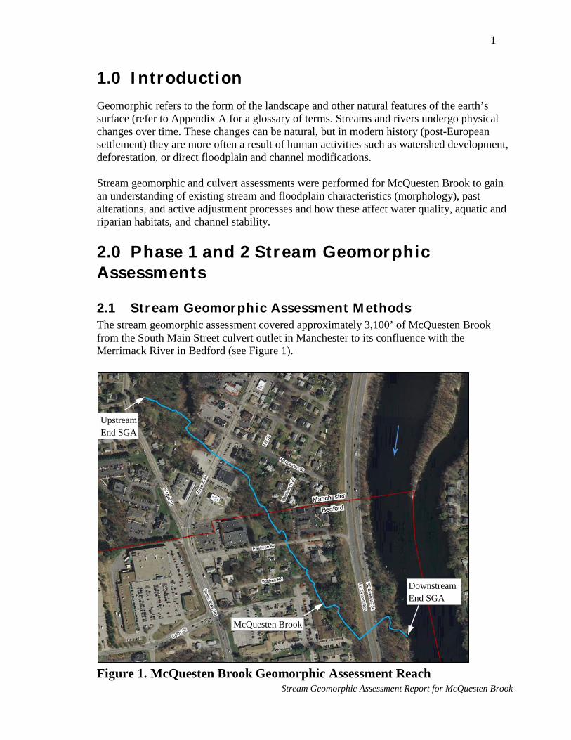
1
1.0 I ntroduction Geomorphic refers to the form of the landscape and other natural features of the earth’s surface (refer to Appendix A for a glossary of terms. Streams and rivers undergo physical changes over time. These changes can be natural, but in modern history (post-European settlement) they are more often a result of human activities such as watershed development, deforestation, or direct floodplain and channel modifications. Stream geomorphic and culvert assessments were performed for McQuesten Brook to gain an understanding of existing stream and floodplain characteristics (morphology), past alterations, and active adjustment processes and how these affect water quality, aquatic and riparian habitats, and channel stability.
2.0 Phase 1 and 2 Stream Geomorphic Assessments
2.1 Stream Geomorphic Assessment M ethods The stream geomorphic assessment covered approximately 3,100’ of McQuesten Brook from the South Main Street culvert outlet in Manchester to its confluence with the Merrimack River in Bedford (see Figure 1).
Figure 1. McQuesten Brook Geomorphic Assessment Reach
Upstream End SGA
Downstream End SGA
McQuesten Brook
Stream Geomorphic Assessment Report for McQuesten Brook

2
The assessment followed the “NH Implementation” of the Phase 1 and 2 Vermont Stream Geomorphic Assessment (SGA) Protocols1. These protocols, developed by the Vermont Agency of Natural Resources (VTANR) and modified slightly by the NHDES New Hampshire Geological Survey (NHGS), use remote sensing and field-collected data to assess watershed, stream corridor, and channel conditions for use in developing management strategies intended to preserve and restore high-functioning stream channels and floodplains, protect and improve surface water quality (sediment and nutrients), and prevent property and infrastructure damage from fluvial erosion (erosion caused by flowing water). Field measurements were collected in April and August 2012. Cross-sections were surveyed using a laser level and tape. Other features relevant to the assessment were located using sub-meter GPS. Both the City of Manchester and the Town of Bedford provided digital 2-foot contour interval topography, which was extremely useful in completing the assessment. ArcGIS (version 10.0) and the Stream Geomorphic Assessment Tool (SGAT) extension (version 10.0.3) were used to compile and analyze the data. Because detailed measurements of the channel and floodplain/overbanks were collected as part of the Phase 2 assessment, only a partial Phase 1 assessment was performed. Phase 1 assessments typically utilize predominantly remote sensing data (topographic maps, aerial photographs, etc.); however, due to the small size of the stream, it is not clearly visible on aerial photos and it was therefore necessary to field-locate the channel using GPS. Under the Phase 1 assessment, the stream was divided into “reaches” with similar valley characteristics, primarily slope and confinement (i.e. ratio of valley width to channel width). The Phase 1 results returned the “reference” (i.e. stable, highest functioning) stream type, per the Rosgen stream classification system (Rosgen 1996), for each reach. Refer to Appendix B for a description of reference stream types. For the Phase 2 assessment, the stream reaches identified under Phase 1 were confirmed in the field and each reach was divided into “segments” with similar characteristics (e.g. channel dimensions, pattern, slope, materials, incision, aggradation, etc.). Phase 2 field forms, including Rapid Geomorphic Assessment (RGA) and Rapid Habitat Assessment (RHA) forms, were completed for each segment. Data collected within each segment included: • Rationale for the segment break; • Locations of stream corridor encroachments (e.g. berms, roads, development, etc.); • Slope and texture of terraces/hillsides adjacent to the channel and/or valley bottom; • Presence, location, and height of any grade controls (e.g. bedrock, dam, etc.); • Channel and floodplain dimensions measured at one representative, valley-wide
cross-section;
1 Kline, M., C. Alexander, S. Pytlik, S. Jaquith and S. Pomeroy. 2007. Vermont Stream Geomorphic Assessment Protocol Handbooks and Appendices. Published at: www.vtwaterquality.org/rivers/htm. Vermont Agency of Natural Resources, Waterbury, VT
Stream Geomorphic Assessment Report for McQuesten Brook

3
• Channel materials determined from a pebble count performed within a representative portion of the segment;
• Representative riffle/step spacing; • Number of pieces of large woody material within the channel; • Average size of the largest particle on the streambed and depositional bar, if any; • Streambank characteristics (slope, texture, erosion, and vegetation); • Location and length of any streambank revetments (e.g. riprap, retaining walls, etc.); • Location, length, and height of any mass slope failures or gullies; • Buffer and riparian corridor characteristics (cover type, vegetation type, and buffer
width); • Presence and location of springs, seeps, tributaries, and adjacent wetlands; • Flow status at the time of the field work (low, moderate, or high); • Number of debris jams; • Type and number of flow regulations and water withdrawals; • Type, number, and location of any stormwater outfalls; • Type, number, and location of any channel or valley constrictions (e.g. culverts,
bridges, bedrock outcrops, etc.); • Number and location of any beaver dams and the length of channel affected; • Type, number, and location of any depositional features (e.g. mid-channel bars, delta
bars, etc.); • Type and location of any significant planform changes (e.g. avulsions, flood chutes,
braiding, etc.); • Type, number, and location of any significant bedform changes indicative of
aggradation or degradation (e.g. steep riffles, head cuts, or tributary rejuvenation); • Number and location of any stream fords or animal crossings; and • Type and location of any channel alterations (e.g. dredging, straightening,
windrowing, etc.) and the length of channel affected. In addition, the valley walls delineated under Phase 1 were confirmed and/or modified based on field observations and measurements and geo-referenced ground photographs of several of the documented features (e.g. depositional bars, bank erosion, stormwater outfalls, etc.) were captured. The cross-section and pebble count data recorded in the field was entered into the MS Excel SGA Phase 2 Survey Datasheet (version 1.7) for automated processing of several parameters including bankfull channel dimensions, width-to-depth ratio, entrenchment ratio, existing stream type, incision ratio, and particle size distributions. These parameters and the other data were used to complete RHA and RGA forms for each segment with the appropriate form selected based on the channel gradient and confinement. RHA and RGA scores were determined for each segment and used to assign qualitative habitat and geomorphic conditions (reference, good, fair, or poor). Also, the channel evolution stage and dominant geomorphic processes were identified as part of the RGA. The final step of
Stream Geomorphic Assessment Report for McQuesten Brook

4
the RGA involved assigning a stream sensitivity rating (very low, low, moderate, high, very high, or extreme) based on the existing stream type and geomorphic condition. The sensitivity ratings were used in conjunction with the measured bankfull channel widths and existing stream types to assign a Fluvial Erosion Hazard (FEH) corridor width to each segment.
The assessment data was recorded in an MS Access database provided by the NHGS. The database, MS Excel Phase 2 Survey Datasheet, field forms, geo-referenced ground photos, and SGAT/GIS project were submitted to Mr. Shane Csiki, Fluvial Geomorphology Specialist with the NHGS, for review and approval. The approved assessment results were used to identify stressors to channel stability, analyze departure from reference conditions, assign sensitivity ratings to each segment, and develop management recommendations, all per the procedures described in the VTANR River Corridor Planning Guide and accompanying Mapping Appendix2.
2.2 Phase 1 Stream Geomorphic Assessment Results The assessed portion of McQuesten Brook was broken into 3 reaches based upon channel confinement. From downstream to upstream, the reaches are labeled M01, M02, and M03 as shown on Figure 2. Reach breaks were located at points where the valley width changes significantly, such that the reference stream type would also change.
Figure 2. Phase 1 Reaches
2 Kline, M. 2010. Vermont ANR River Corridor Planning Guide: to Identify and Develop River Corridor Protection and Restoration Projects, 2nd edition. Vermont Agency of Natural Resources. Waterbury, Vermont.
Stream Geomorphic Assessment Report for McQuesten Brook

5
The valley widths in reaches M01 and M03 are less than in reach M02. Given these valley characteristics, the stream within reach M02 would be expected to be low gradient, sinuous, and bordered by broad floodplains, whereas the stream within M01 and M03 would likely be higher gradient and straighter with floodplains being absent or very narrow; that is, the reference stream type where the valley is broad would be different than where it is narrow.
Table 1 summarizes the valley and channel morphology determined from remote sensing data. Note that the bankfull channel width was estimated using the drainage area and the Vermont Regional Hydraulic Geometry Curves. Although regional hydraulic geometry curves have been developed for New Hampshire, the data set used to develop them includes a significant number of stream gage sites within high elevation watersheds in the White Mountains physiographic region. It is our experience that the Vermont Curves more accurately predict channel dimensions in lower elevation watersheds in central and southern New Hampshire.
2.3 Phase 2 Stream Geomorphic Assessment Results The reach breaks identified under Phase 1 were confirmed in the field and each stream reach was divided into “segments” with similar morphological characteristics. A total of nine segments were identified – three in reach M01, four in reach M02, and two in reach M03. Figure 3 below identifies the delineated stream segments.
Table 1. Phase 1 Assessment Results
Reach Valley Slope
Channel Slope Sinuosity
Bankfull Channel Width
(ft)
Valley Width
(ft) Confinement
Reference Stream Type
M01 0.57% 0.56% 1.02 13.1 21.5 1.6 B M02 0.61% 0.57% 1.06 12.8 99.7 7.8 E M03 3.19% 3.11% 1.03 11.4 24.1 2.1 B
Stream Geomorphic Assessment Report for McQuesten Brook

6
Figure 3. Phase 2 Segments
Table 2 summarizes the reference stream type, existing stream type, geomorphic condition, and dominant channel adjustment process for each segment.
Table 2. Phase 2 Assessment Results
Segment Stream Type* Geomorphic
Condition Adjustment Process Reference Existing M01A B G5 Fair Widening after incision
(early channel evolution stage III)
M01B B G3 Fair None (bed and banks armored)
M01C B B5 Good None
M02A E C5 Fair Widening, aggradation, and planform
changes after incision (late stage III/early stage IV)
M02B E E5 Good None M02C E G5 Fair None M02D E E5 Good None
M03A B F4 Fair Widening, aggradation, and planform changes after historic straightening
(late stage III/early stage IV)
M03B** n/a n/a n/a None (bed and banks armored)
* per the Rosgen (1996) Stream Classification System ** stream types were not assigned to segment M03B as it is a concrete-lined channel and unable to adjust its boundaries
Stream Geomorphic Assessment Report for McQuesten Brook

7
As indicated in the previous table, departures from the reference stream type have occurred in several segments. Overall, three of nine segments, representing about 50% of the total assessed stream length, are in good condition with the existing stream types being the same as the reference stream types. The remaining six segments, representing the remaining 50% of the assessed channel length, are in fair condition and have departed from their reference stream types. Table 3 below summarizes the habitat condition for each segment as determined from the RHA.
Table 3. Habitat Condition Ratings Segment Habitat Condition
M01A Fair M01B Fair M01C Good M02A Fair M02B Good M02C Fair M02D Good M03A Fair M03B Poor
As indicated in the two tables above, the geomorphic and habitat condition ratings are the same for all segments where both ratings were assigned. Brief descriptions of each assessed segment are provided below and photos of each segment are included in Appendix C. Table 4 summarizes the median channel material particle sizes for each segment as determined from pebble counts. The channel material sizes were used along with cross-section, slope, and sinuosity measurements to determine existing stream types. The existing stream types were used in conjunction with the geomorphic condition scores to assign a sensitivity rating (see Section 3) for each segment. The stream types and sensitivity ratings were also used to determine the FEH corridor widths (see Section 3). The size of the channel materials is indicative of the bankfull channel depth and slope and the stream’s ability to transport sediments of various sizes. Channel material size is an important habitat feature as different organisms require different size substrate.
Stream Geomorphic Assessment Report for McQuesten Brook

8
Table 4. Median Channel Material Particle Size Segment Particle Size (mm) Description
M01A 0.5 medium/coarse sand M01B 67 small cobble
M01C 0.7 course sand (bimodal
distribution between sand and boulder-sized particles)
M02A 0.7 coarse sand M02B 0.4 medium sand M02C 0.25 fine/medium sand M02D 0.6 coarse sand M03A 6 fine gravel M03B
Table 5 summarizes the bankfull channel and valley geometries measured at representative cross-sections within each segment. The channel and valley dimensions were used along with particle size, slope, and sinuosity measurements to determine existing stream types and complete the RGA. The existing stream types and RGA scores were used to assign a sensitivity rating (see Section 3) for each segment. The stream types and sensitivity ratings were also used to determine the FEH corridor widths (see Section 3). Channel dimensions are critical to characterizing existing stream morphology, understanding channel evolution trends, and planning for stream corridor protection and restoration.
Table 5. Representative Bankfull Channel and Valley Geometry
Segment
Bankfull Width (Wbkf) (feet)
Bankfull Depth (Dbkf) (feet)
Width/Depth Ratio
(W/D Ratio)
Incision Ratio
Width of Flood Prone Area
(Wfpa) (feet)
Entrenchment Ratio
(Wfpa/Wbkf)
M01A 16.9 1.9 9 22.5 1.3 M01B 13.6 1.3 10 18.5 1.4 M01C 15 1.2 13 1 29 1.9 M02A 18.5 1.1 17 1.6 88 4.8 M02B 10.5 1.1 10 1 96.5 9.2 M02C 10.4 1.1 9 2.1 18 1.7 M02D 10.5 1.2 9 1 100 9.5 M03A 16.8 0.9 18 2.9 22 1.3 M03B* 7.9 0.9 9 5.5 14 1.8
Notes: *M03B – Due to the non-erodible bed and banks, the channel cannot adjust its boundaries in the short term; therefore, the dimensions measured represent the constructed cross-section rather than a product of the local geology and watershed inputs.
1. Bankfull width (Wbkf) is the width of flow at the bankfull stage. 2. Bankfull depth (Dbkf) is the average depth measured at the bankfull stage. 3. Incision ratio is the ratio of the height of the recently abandoned floodplain (measured from the
thalweg or lowest point) to the maximum bankfull depth. 4. Width of flood prone area (Wfpa) is the flow width at twice the maximum bankfull depth. 5. Entrenchment ratio is Wfpa/Wbkf.
Stream Geomorphic Assessment Report for McQuesten Brook

9
Segment M01A Segment M01A begins at the brook’s confluence with the Merrimack River and extends upstream about 510’ to the inlet of the 48” concrete culvert beneath I-293. The upper 220’± of the segment are within the culvert. Downstream from the culvert, the brook flows within a narrowly confined, sinuous valley cut through high, sandy terraces on the west side of the Merrimack River. The valley is not significantly wider than the bankfull channel, resulting in a very low entrenchment ratio. The reference stream type is B and the existing stream type is G5. Review of historic aerial photography predating the interstate showed that several hundred feet of sinuous stream channel immediately upstream from the culvert outlet were filled and the stream placed in a pipe much shorter than the abandoned section of stream when the interstate was constructed. The increased slope and stream power associated with this reduction in stream length along with increased bed scour resulting from high velocity flows exiting the undersized culvert likely contributed to the channel incision observed throughout the segment, though the natural valley setting may also contribute to the incised condition. Degradation of the streambed has undercut the high sandy banks/valley walls resulting in widespread bank erosion and mass failures. The extensive bank erosion and mass wasting suggest that the channel is actively widening (early channel evolution stage III); however, due to the high banks, which deliver prodigious volumes of sediment to the stream with relatively minor lateral shifts in the channel boundaries, the rates of channel widening and lateral migration appear to be relatively slow. Segment M01B Segment M01B begins at the inlet of the 48” concrete culvert beneath I-293 and extends upstream about 140’. The entire length of the segment has been straightened, the historic sinuous channel replaced with a deep, straight trapezoidal one likely constructed as part of the interstate project. Commercial development lies just beyond the top of the high right bank/valley wall and the interstate borders the top of the left bank/valley wall. The lower banks and streambed have been armored with angular riprap. One area of mass wasting, about 34’ long and 18’ high, lies on the right bank/valley wall and one large stormwater outfall enters along the right bank. The “modified” reference stream type is B and the existing stream type is G3. Due to the riprap bed and bank armoring, the channel is not actively adjusting. Segment M01C Segment M01C begins at the upstream end of channelization and extends upstream about 190’ to the reach 1-2 break, which occurs at an abrupt valley constriction. A significant lag deposit of large boulders covers the stream bed and banks at, and downstream from, the reach break. The stream flows through a narrowly confined valley with narrow active floodplains, accessible by floods at or just exceeding the bankfull stage, along one or both banks for most of the segment length. Both the reference and existing stream type is B (i.e. no departure). Riparian buffers are intact and the channel does not appear to have been straightened.
Stream Geomorphic Assessment Report for McQuesten Brook

10
The stream is in good geomorphic condition and functioning near equilibrium. It is not actively adjusting (channel evolution stage I). Segment M02A Segment M02A begins at the valley constriction (reach break) and extends upstream approximately 340’ to Wathen Road. The brook flows through a narrow alluvial valley up against the right (west) valley wall. Its position on the edge of the valley suggests it may have been straightened; however, no evidence of an abandoned channel was observed in the forested terrace bordering the left bank; therefore, it was not mapped as being straightened. The top of the left bank and adjacent alluvial surface was measured to be about 0.9’ higher than the bankfull flood stage at the cross-section, indicating that the channel is incised and no longer has access to a floodplain during flows at or just above bankfull. The measured incision ratio was 1.6, indicating the channel is deeply incised. About 170’ of the right bank in the upper part of the segment is actively eroding. In addition, a section of the right valley wall approximately 25’ long and 18’ high has failed. Five significant sediment deposits were mapped within the segment. It is likely that bank erosion and stormwater runoff are the primary sediment sources. A large storm drain discharges along the right bank about 80’ downstream from the Wathen Road culvert outlet. In addition, a paved swale which collects runoff from Wathen Road itself empties into the brook near the culvert outlet. The reference stream type is E and the existing stream type is C5. The channel is actively widening, aggrading, and adjusting its planform following historic incision (late channel evolution stage III/early stage IV). Segment M02B Segment M02B begins at Wathen Road and extends upstream approximately 1,050’ to the outlet of the Second Street culvert. Within this segment the brook flows through a broad alluvial valley covered by active, wetland floodplains supporting a dense mix of trees, riparian shrubs, and herbs. There have been some encroachments on the channel and floodplains, including the crossings at Wathen Road and Eastman Avenue, an 85’ long stone retaining wall along the right bank/valley wall just upstream from Eastman Avenue, and stones placed along the toes of both banks (125’ left, 95’ right) about halfway between Eastman Avenue and Second Street; however, these encroachments have not had a significant impact on channel form or process and the floodplains are available to accommodate future lateral channel adjustments (i.e. meander belt width) and attenuate flood flows, fine sediment, and nutrients. Indeed, flow and sediment attenuation that occurs in this segment benefits downstream areas as observed during an intense thunderstorm which occurred while collecting field data in August 2012. Flows started to rise shortly after the storm began and quickly overtopped the banks and spread onto the floodplains. Shallow overland flow and areas of standing water persisted for several hours after the storm had passed and it was not until the following day that the stream returned to near base flow conditions.
Stream Geomorphic Assessment Report for McQuesten Brook

11
In addition to the encroachments described in the previous paragraph, an old stone masonry dam extends from the downstream end of the aforementioned stone retaining wall about 7’ across one branch of the channel and connects with an isolated boulder in the floodplain. Some water flows through voids in the old dam and reemerges immediately downstream; however, a new primary channel has formed which meanders to the east, then south around the old dam and boulder. The channel which emerges on the downstream side of the old dam joins the primary channel immediately upstream from the Eastman Avenue culvert. Due to the broad width of the floodplain in this area (approximately 80’) relative to the length of the obstruction, the old dam has not had significant adverse impacts on channel stability or aquatic organism passage as there is sufficient area for the stream to migrate around this obstruction, as it has done. Only a single in-stream depositional feature was mapped – a large sand deposit about 80’ downstream from the Second Street culvert outlet. This deposit and the accumulated sediment on the floor of the culvert, measured to be in excess of 3’ thick at the inlet and outlet, suggest that a significant volume of sediment is being deposited at the upstream end of the segment. This is not surprising as it is the first area with broad floodplains downstream from a channelized source/transport segment and multiple sources of stormwater runoff. The stream is in good geomorphic condition, functioning near equilibrium, and is not actively adjusting (channel evolution stage I). Both the existing and reference stream type is an E. Segment M02C Segment M02C begins at the outlet of the Second Street culvert and extends upstream about 400’ to the upstream end of the paved parking lot paralleling the left bank. The lower 210’± of the segment are within the culvert and the upper 190’± of the segment have been channelized such that it flows between the parking lot and the right valley wall. This segment is located in the same broad alluvial valley containing segments M02B and M02D, though all of the floodplain area along the left bank has been filled for development. The measured incision ratio is greater than 2, indicating that the stream does not have access to a floodplain even when maximum flood depths are double the maximum bankfull depth. The reference stream type is E and the existing stream type is G5. (Note that the measured width-to-depth ratio is characteristic of G-type streams and the measured entrenchment ratio is in the range typical of F-type streams. We assigned a G-type stream classification as G-type morphology typically precedes F-type morphology in the channel evolution model for incised streams. If bank erosion and channel widening occurs, the width-to-depth ratio would likely increase such that the stream would key out to an F-type stream). The right bank/valley wall is well vegetated with trees and shrubs, including a dense stand of invasive Japanese knotweed. A few trees and patches of herbaceous vegetation line the left bank, though vegetation removal and maintenance has severely reduced the width and density of the riparian buffer. Despite the absence of vegetation or substantial hard armoring along the left bank, there is no significant active bank erosion. Although the left bank is not actively eroding, the incised channel condition and minimal protection make the bank vulnerable to erosion such that changes to the sediment and/or hydrologic regime (e.g.
Stream Geomorphic Assessment Report for McQuesten Brook

12
increased sediment deposition) could easily trigger erosion and conflicts with the adjacent land use. The stream is in fair geomorphic condition, though as previously described, it is not actively adjusting. Segment M02D This segment begins at the upstream end of the parking lot and continues upstream approximately 310’ to a valley constriction marking the break between reaches 2 and 3. Downstream from the reach break the brook flows through a broad alluvial valley bordered on both sides by active, forested/shrubby floodplains. There are no significant encroachments on the stream or floodplain, which remains available to accommodate future lateral channel adjustments and attenuate flood flows, fine sediment, and nutrients. Indeed, this is the first area of broad floodplains the streamflow encounters after flowing through approximately 3,200’ of culvert and 200’ of channelized stream. The flow and sediment storage which occurs in this segment is beneficial to downstream areas.
One storm drainage channel discharges to the stream on the right bank about 50’ upstream from the parking lot and the outflow from McQuesten Pond enters the brook on the left bank approximately 115’ upstream from the parking lot. Two substantial in-stream deposits were mapped within the segment. One of these, located about 30’ upstream from the McQuesten Pond inflow, has led to the formation of a flood chute which departs the main channel along the right bank and returns about 80’ further downstream. Because there is no significant bank erosion within the segment, it appears the source of this sediment is from upstream erosion in segment M03A and/or stormwater runoff. The stream is in good geomorphic condition, functioning near equilibrium, and is not actively adjusting (channel evolution stage I). Both the existing and reference stream type is E. Segment M03A This segment begins at the reach 2-3 break and extends upstream about 150’ to the end of a concrete-lined channel. The channel in this segment flows through a narrowly confined artificial valley created when the channel itself was excavated and the spoils placed along the left bank to create a large berm which was considered to be a valley wall under the SGA. The right valley wall is a natural feature. It does not appear that the channel was historically located in this area and that it was excavated in conjunction with the construction of the extensive closed drainage system and residential development located just upstream. The stream power of the constructed channel clearly exceeded the boundary resistance as it has been, and continues to, evolve toward a morphology with lesser stream power by eroding, widening, and adjusting its planform; thus becoming shallower and flatter. Active erosion was mapped along about 50’ of the left bank and 90’ of the right bank and a total of 4 in-stream depositional features were identified. A dilapidated concrete dam (“South Main Street Dam”) is located about 30’ from the upstream end of the segment. This structure has
Stream Geomorphic Assessment Report for McQuesten Brook

13
been outflanked along the left bank such that water flows around the structure and is no longer impounded. The original use of this structure is unknown, but may have been constructed to create a stilling basin to reduce the energy of the flows spilling out of the concrete-lined channel. The structure is contributing to accelerated erosion of the left bank where flows are constricted between the bank and dam remnants. Due to the artificial confinement, the reference stream type is likely B; however, due to the erodibility of left valley wall (fill), the channel could eventually evolve into a meandering, alluvial stream (i.e. C or E stream type). Currently, the stream is actively widening, aggrading, and adjusting its planform (late channel evolution stage III/early stage IV).
Segment M03B This segment includes a 50’± long section of concrete-lined channel at the upstream end of the reach and study area. After flowing through approximately 3,200’ of culvert, the brook spills out of a 66” diameter concrete pipe, flows down this channel, and cascades into a large pool just upstream from the dilapidated South Main Street Dam. Due to the non-erodible bed and banks, the channel cannot adjust its boundaries in the short term.
3.0 Stressor I dentification, Depar ture Analysis, and Stream Sensitivity The Phase 2 SGA data and results were used to identify significant stressors to channel stability, departure from reference (equilibrium) conditions, and the sensitivity of each stream segment. The stressor identification, departure analysis, and sensitivity rating were performed in accordance with the VTANR River Corridor Planning Guide and accompanying Mapping Appendix. Stressor Identification The SGA data and results were used to identify significant stressors to channel stability and departure from reference (equilibrium) conditions. Stressors to the hydrologic and sediment regimes were considered at both the watershed-scale (e.g. changes to watershed hydrology resulting from urbanization) and reach-scale (e.g. removal of bank and riparian vegetation). The following Stressor Identification Maps, developed in accordance with the VTANR River Corridor Planning Guide and accompanying Mapping Appendix, were created to illustrate these stressors. These maps are included in Appendix D. • Hydrologic Alterations Map • Land Cover Map • Sediment Load Indicators Map • Channel Slope Modifiers Map • Channel Depth Modifiers Map • Boundary Conditions and Riparian Modifiers Map Stressors to each stream segment are summarized in Table 6.
Stream Geomorphic Assessment Report for McQuesten Brook

Table 6. Stressor Identification Table
Segment Watershed-Scale Stressors Reach-Scale Stressors Hydrologic Sediment Load Stream Power Boundary Resistance
M01A
High (Increased magnitude & frequency of
flood flows due to urbanization – watershed impervious cover is ~34%)
Extreme (Increased load from extensive bank erosion/ mass wasting within
segment, upstream bank erosion/mass wasting, & runoff of winter sand)
Increased stream power associated with increased depth due to channel incision, trend is decreasing
stream power as channel widens
Decreased boundary resistance due to removal of streambank vegetation from bank erosion/mass wasting & scour below root zone due to channel
degradation
M01B Extreme
(Increased flows due to urbanization & stormwater outfalls within segment)
Moderate (Increased load from minor mass wasting within segment, upstream bank erosion/mass wasting, & winter sand, offset to some degree by decrease surface erosion resulting from high % impervious cover)
Increased stream power associated with increased depth & slope due to channel straightening &
roadway/development encroachments
Increased boundary resistance due to armoring of bed & banks with rock riprap
M01C High (Increased flows due to urbanization)
Moderate (Increased load from upstream bank erosion/mass wasting & winter
sand, offset to some degree by decrease surface erosion resulting from high % impervious cover)
No significant changes to equilibrium stream power Increased boundary resistance due to maintenance of woody streambank & riparian vegetation
M02A Extreme
(Increased flows due to urbanization & stormwater outfalls within segment)
High (Increased load from bank erosion/mass wasting within segment &
winter sand, offset to some degree by decrease surface erosion resulting from high % impervious cover & fine sediment storage by broad active
floodplains within segment immediately upstream)
Decreased stream power due to decreased depth associated with channel widening
Decreased boundary resistance due to removal of streambank vegetation from bank erosion & scour
below root zone due to channel degradation
M02B High (Increased flows due to urbanization)
Moderate (increased load from winter sand offset to some degree by decrease
surface erosion associated with high % impervious cover & fine sediment storage by broad active floodplains within segment)
No significant changes to equilibrium stream power except immediately upstream from undersized culverts at Wathen Road & Eastman Avenue
Increased boundary resistance due to maintenance of woody streambank & riparian vegetation
M02C Extreme
(Increased flows due to urbanization & stormwater outfalls within segment)
High (increased load from runoff of winter sand delivered via multiple
stormwater outfalls within segment, offset to some degree by decrease surface erosion associated with high % impervious cover & fine
sediment storage by broad active floodplains within segment immediately upstream)
Increased stream power associated with increased depth & slope due to channel straightening, development encroachments, & stormwater
discharges; offset to some degree by decreased stream power associated with undersized culvert at
Second Street
Decreased boundary resistance due to removal of streambank & riparian vegetation associated with
development along left bank
M02D High (Increased flows due to urbanization)
Moderate (increased load from winter sand offset to some degree by decrease
surface erosion associated with high % impervious cover & fine sediment storage by broad active floodplains within segment)
No significant changes to equilibrium stream power Increased boundary resistance due to maintenance of woody streambank & riparian vegetation
M03A
Extreme (Increased flows due to urbanization,
segment just downstream from outfall of 3200’ of culverted stream)
High (Increased load from widespread bank erosion within segment & winter sand, offset to some degree by decrease surface erosion resulting from
high % impervious cover)
Decreased stream power due to decreased depth associated with channel widening
Decreased boundary resistance due to removal of streambank vegetation from bank erosion & scour
below root zone due to channel degradation
M03B
Extreme (Increased flows due to urbanization, segment ends at outfall of 3200’ of
culverted stream)
Moderate (increased load from winter sand offset to some degree by decrease
surface erosion associated with high % impervious cover)
Increased stream power associated with increased depth & slope due to channel straightening &
stormwater discharges
Increased boundary resistance due to armoring of bed & banks with concrete and large rock
Stream Geomorphic Assessment Report for McQuesten Brook

15
Departure Analysis The impacts of the aforementioned stressors on the sediment regime, that is, the quantity, size, transport, sorting, and distribution of sediments (VTANR, 2010), are shown on the Sediment Regime Departure Maps in Appendix D. The following two maps have been prepared in accordance with the VTANR River Corridor Planning Guide and accompanying Mapping Appendix: • Reference Sediment Regime Map • Existing Conditions Sediment Regime Map The Reference Sediment Regime Map identifies the sediment regime that would exist in the absence of human stressors whereas the Existing Conditions Sediment Regime Map illustrates the current sediment regime for each segment. Comparing these two maps shows where and how the sediment regime has changed, which is important to understanding the present channel evolution stage, future channel evolution stages the stream will experience as it evolves toward a stable (equilibrium) condition, and how channel adjustments in one segment are likely to influence the adjustments and stability in another segment. This information is critical to making the best possible management decisions. Confined stream reaches M01 and M03 would have transport-dominated sediment regimes under reference conditions, but due to straightening, encroachments, and bed degradation, the majority of these reaches (segments M01A, M01B, and M03A) now both supply and transport a significant volume of sediment. That is, there has been a departure from the reference sediment regime. Unconfined reach M02 would have an equilibrium sediment regime under reference conditions where the channel has the power to transport its coarse sediment load and attenuate (store) significant volumes of fine sediment via deposition on the active floodplains adjacent to the channel. About 65% of reach M02 (segments M02B and M02D) still has an equilibrium sediment regime. Due to past incision (i.e., cutting into the bed of the channel) and ongoing widening and aggradation (i.e., raising the stream bed level by sediment deposition), Segment M02A, which represents about 16% of the reach length, no longer stores significant amounts of fine sediment (due to floodplain disconnection) but is now a source of both fine and coarse sediment. Fine sediment (wash load) is transported in suspension to reach M01 and the Merrimack River and coarse sediment (bed load) is deposited on the streambed within the segment. The reference sediment regime in segment M02C has also changed from equilibrium and fine deposition to source and transport due to channel straightening and encroachments which have increased stream power and decreased access to adjacent floodplains. However, there is little active bank erosion in this segment; therefore, it is not a significant source of sediment. Table 7 and the attached Sediment Regime Departure Maps are useful in assessing how adjustments in one segment may be affecting the stability of another segment.
Stream Geomorphic Assessment Report for McQuesten Brook

16
Table 7 also identifies segments that: • are constrained from adjusting vertically and/or laterally, whether from natural or
human-constructed conditions; • have a transport-dominated sediment regime that is either natural or a result of
departure from reference conditions; and • are in a naturally high deposition zone, are experiencing increased sediment
deposition, or are a potential asset where future sediment deposition could occur.
Identification of these constraints, sediment regime characteristics, and sediment storage possibilities is particularly useful for evaluating and prioritizing stream corridor protection and restoration opportunities.
Table 7. Departure Analysis Table
Segment Adjustment Constraints
Transport-Dominated
Sediment Regime
Sediment Attenuation (storage)
Vertical Lateral Natural Converted Natural Increased Asset M01A
M01B
(bed
armor and I-293
culvert)
(riprap on
both banks, I-293 along left bank &
development along right
bank)
M01C M02A
M02B
(culverts
at Wathen Rd. &
Eastman Ave.)
M02C
(culvert
at Second
St.)
(development
along left bank
upstream from Second
St.)
M02D M03A `
M03B
(concrete channel bottom)
(bank armor)
Stream Geomorphic Assessment Report for McQuesten Brook

17
Table 7 indicates that human-constructed constraints to lateral adjustments in M01B, M02C, and M03B likely make managing these segments toward reference conditions impracticable and that a “modified” reference condition may be a more feasible strategy. The table also shows that segments M02B and M02D, both located in unconfined valley settings and in good condition, lie immediately downstream from segments which have evolved from their reference equilibrium/fine deposition sediment regimes to transport-dominated sediment regimes, suggesting that these two segments are prime candidates for corridor protection. More detailed recommendations are included in Section 6.0. Stream Sensitivity The existing stream type and geomorphic condition determined from the Phase 2 SGA were used to assign a sensitivity rating to each segment. These sensitivity ratings indicate the likelihood of future vertical and lateral erosion and take into account the inherent sensitivity of the stream and the impact of any active adjustment processes. Table 8 below summarizes the existing stream type, geomorphic condition, and sensitivity rating for each segment.
Table 8. Stream Sensitivity Ratings
Segment Existing Stream
Type* Geomorphic
Condition Sensitivity Rating M01A G5 Fair Very High M01B G3 Fair Very High M01C B5 Good Moderate M02A C5 Fair Very High M02B E5 Good High M02C G5 Fair Very High M02D E5 Good High M03A F4 Fair Very High M03B n/a n/a n/a
* per the Rosgen (1996) Stream Classification System ** existing stream type was not assigned to segment M03B (concrete-lined channel), therefore geomorphic condition and
sensitivity ratings were also not assigned The Stream Channel Sensitivity Map in Appendix B graphically illustrates the sensitivity rating assigned to each segment. This map also shows the history of vertical channel adjustments (i.e. aggradation and degradation).
4.0 Fluvial Erosion H azard Area M apping The existing stream types, sensitivity ratings, bankfull channel widths, and mapped meander centerline and valley walls were used to delineate a fluvial erosion hazard (FEH) area for each segment and an overall FEH corridor along the entire assessed portion of McQuesten Brook. The FEH corridor mapping followed the procedures described in the VTANR River
Stream Geomorphic Assessment Report for McQuesten Brook

18
Corridor Protection Guide3 which are based on the concept of identifying a corridor within the valley, which is of sufficient width to accommodate the meander geometry, slope, and vegetated buffers of the channel in its stable (equilibrium) form. In the case of an unstable stream, the FEH corridor encompasses the area needed for the stream to evolve to, and maintain, a stable form (i.e. reference or equilibrium condition). In the case of an existing stream in reference condition, the FEH corridor includes the stream and floodplain areas which should be left unaltered so that equilibrium conditions are maintained. When the FEH corridor is protected to allow evolution toward, or maintenance of, equilibrium conditions, such as via conservation easements, human/stream conflicts are minimized, damage to property and infrastructure are limited, and the ecosystem services afforded by the stream corridor (e.g. floodwater storage, water quality renovation, etc.) are maximized. The FEH areas identified under this study include only the meander belt widths needed to allow reestablishment or maintenance of equilibrium conditions and do not include additional riparian buffers outside of the meander belts. The width of the FEH area in each segment is a function of the reference bankfull channel width, stream sensitivity, and existing stream type as presented in Table 9.
Table 9. FEH Corridor Widths Sensitivity
Rating Existing Stream Types FEH Corridor Width
Very Low (VL) All One (1) reference bankfull channel width Low (LW) All Two (2) reference bankfull channel widths
Moderate (MD) All Four (4) reference bankfull channel widths High (HI) All except E4, E5, or E6 Six (6) reference bankfull channel widths High (HI) E4, E5, or E6 Eight (8) reference bankfull channel widths
Very High (VH) All Six (6) reference bankfull channel widths
Extreme (EX) All except D3, D4, D5, E4, E5, or E6
Six (6) reference bankfull channel widths
Extreme (EX) D3, D4, D5, E4, E5, or E6 Eight (8) reference bankfull channel widths In most areas the width of the FEH corridor exceeded the width of the valley, resulting in the FEH corridor occupying the entire valley width. The final FEH corridor delineation, developed with the assistance of the NHGS, is shown on the FEH Rating Map in Appendix D.
3 Kline, M. and K. Dolan. 2008. Vermont ANR River Corridor Protection Guide: Fluvial Geomorphic-Based Methodology to Reduce Flood Hazards and Protect Water Quality. Vermont Agency of Natural Resources. Waterbury, Vermont.
Stream Geomorphic Assessment Report for McQuesten Brook

19
5.0 Culver t Assessments
5.1 Culver t Assessment M ethods Four roads cross the assessed portion of McQuesten Brook. From downstream to upstream these are: Interstate 293, Wathen Road, Eastman Avenue, and Second Street. A round culvert carries McQuesten Brook under each of these roads. The New Hampshire Culvert Assessment Protocols (version 1.2) developed by the New Hampshire Fish and Game Department (NHFG) and now under the stewardship of NHGS were used to assess each crossing’s compatibility with the stream geomorphology at the crossing site and ability to allow aquatic organism passage (AOP). The culvert assessments were completed in August 2012. Measurements were made using a laser level and tape. Data collected at each crossing included: • Crossing location (road name and GPS state plane coordinates); • Culvert materials (e.g. concrete, plastic, steel, etc.); • Culvert shape, dimensions, length, slope, and skew to roadway; • Culvert condition (e.g. new, rusted, etc.); • Flow conditions at the time of the field work; • Degree of floodplain obstruction; • Flow depth and velocity in culvert relative to depth and velocity in stream; • Presence and type of obstruction (e.g. wood, sediment, etc.); • Estimated consequences of avulsion (sudden change in the course of a stream where
an existing section of the channel is abandoned and a new, straighter, steeper channel is formed) ;
• Angle of flow approaching culvert inlet; • Evidence of bed aggradation or degradation; • Existing and reference bankfull channel widths upstream and downstream from
crossing; • Inlet and outlet invert elevations relative to streambed (e.g. at grade, free fall, etc.); • Presence and height of outlet drop (perch); • Presence and depth of scour pool at outlet; • Comparison of bank heights upstream and downstream from crossing; • Type and location of tailwater control; • Substrate type upstream, downstream, and within culvert; • Depth of substrate within culvert; • Evidence and height of sediment deposits upstream, downstream, and within culvert; • Presence of bank erosion upstream and downstream from culvert; • Presence of bank armoring upstream and downstream from culvert;
Stream Geomorphic Assessment Report for McQuesten Brook

20
• Presence and impact of bed and bank scouring around and under culvert at inlet and outlet;
• Riparian buffer type, size, and location relative to crossing; • Evidence or observations of wildlife in vicinity of crossing; and • Several ground photographs of the culvert inlet and outlet and stream channel
upstream and downstream from the crossing. The data was recorded on the Culvert Assessment Field Forms developed by NHFG and subsequently transferred to an MS Access database provided by the NHGS. The database, field forms, and ground photos were submitted to NHGS for review and approval. NHGS ran the data through the Vermont Culvert Geomorphic Compatibility and Aquatic Organism Passage Screening Tools4 5 to estimate the compatibility of each culvert with flow and sediment transport processes (i.e. geomorphic compatibility) and its ability to provide aquatic organism passage (AOP). The screening tools returned geomorphic and AOP compatibility rankings which identify those culverts most likely to fail and/or restrict the movement of fish and other aquatic organisms. This information was used to prioritize culvert replacement recommendations.
5.2 Culver t Assessment Results The geomorphic compatibility and AOP rankings for each culvert are listed in Table 10 along with other pertinent observations and measurements made at the crossings. Photos of culverts are included in Appendix E.
4 Milone & MacBroom Inc. 2008. The Vermont Culvert Geomorphic Compatibility Screening Tool. Report prepared for Vermont Agency of Natural Resources, Department of Environmental Conservation, River Management Program. South Burlington, Vt.
. 5 Milone & MacBroom Inc. 2009. The Vermont Aquatic Organism Passage Screening Tool. Report prepared for Vermont
Agency of Natural Resources, Department of Fish and Wildlife. South Burlington, Vt. Stream Geomorphic Assessment Report for McQuesten Brook

21
Table 10. Culvert Geomorphic Compatibility and AOP Rankings
Road Segment Geomorphic
Compatibility AOP
Culvert Type &
Dimensions
Percent Bankfull Width
Observations & Measurements
I-293 (Everett
Turnpike) M01A Mostly
Incompatible
No AOP including
adult salmonids
48” RCP 220’ long 30%
Outlet drop: 18”, undermining at outlet (headwall collapsed), stream flow makes sharp bend at inlet, no substrate on culvert bottom, debris jam at inlet
Wathen Road M02B Partially
Compatible Reduced
AOP 36” RCP 30’ long 27%
Culvert slope and low flow velocity greater than channel, low flow depth shallower than channel, no substrate on culvert bottom
Eastman Avenue M02B Mostly
Incompatible Reduced
AOP
36” RCP 50’ long
30%
Stream flow makes sharp bend at inlet, entire length of culvert backwatered at low flow, substrate on culvert bottom throughout
Second Street M02C Mostly
Compatible Reduced
AOP 66” RCP 210’ long 73%
Entire length of culvert back-watered at low flow, substrate >3’ thick on culvert bottom throughout
Descriptions of the geomorphic compatibility and AOP rankings are presented in Tables 11 and 12 below [from the NHGS paper Reporting of Culvert Assessment Rankings and Data, Version 1.0 (February 2013)].
Stream Geomorphic Assessment Report for McQuesten Brook

22
Table 11. Descriptions of Culvert Geomorphic Compatibility Rankings Ranking Description
Fully Compatible
These structures are fully compatible with natural river channel form and process, and are at a low risk of failure. Culvert replacement is not expected over the lifetime of the structure. When replaced, a structure similar to the currently existing one is recommended. Culverts that rank in this category provide examples of the proper sizing and construction at sites where replacements occur to ensure compatibility with flow and sediment transport processes.
Mostly Compatible
These structures are mostly compatible with natural river channel form and process, and are at a low risk of failure. Culvert replacement is not expected over the lifetime of the structure. When replaced, minor design adjustments are recommended to make the culvert fully compatible with river form and process.
Partially Compatible
These structures are either compatible with current form or process, but not both, with any compatibility only likely in the short term. Culvert replacement may be needed, given the moderate risk of failure during its design lifetime. When replaced, a redesign of the culvert installation is suggested to improve the compatibility of the culvert with river form and process.
Mostly Incompatible
These structures are typically undersized for the river or stream channel that contains them, and/or are poorly aligned with the upstream channel geometry, creating a condition where the structures are mostly incompatible with river form and process. As a result, these structures are at a moderate to high risk of structural failure. When replaced, a redesign of the culvert should be initiated to improve the geomorphic compatibility.
Fully Incompatible
These structures are typically undersized for the river or stream channel that contains them, and/or are poorly aligned with the upstream channel geometry, while also showing reduced sediment continuity (passage of bed material through the culvert) and an increased risk for erosion. Culverts ranking in this category are not compatible with river form and process and are at a high risk of failure. Culverts ranking in this category should be prioritized for replacements to improve river geomorphology process compatibility.
Stream Geomorphic Assessment Report for McQuesten Brook

23
Table 12. Descriptions of Culvert AOP Rankings Ranking Description
Full AOP
Stream crossings in this category have one culvert with an outlet that is at grade with the channel bed downstream with no drop (the culvert is not perched), have sediment throughout the structure, and have an upstream structure opening that is not partially obstructed. Essentially, the crossing is functionally no different than the river/stream channel upstream of downstream of it, with leads to the ability of the structure to fully pass aquatic organisms through.
Reduced AOP
Stream crossings in this category can have any of the following conditions, either individually or in combination with each other: (1) have a culvert outlet where flow cascades into the river/stream channel directly downstream of it; (2) have more than one culvert at a crossing; (3) have an upstream structure opening that has some type of obstruction; or (4) a culvert where sediment is not present throughout the structure. These are factors that work to potentially limit AOP for some species or life stages.
No AOP except adult salmonids
Stream crossings in this category have a free fall outlet and a measureable drop directly downstream of the culvert that is less than or equal to 1 foot, given the known strong swimming and leaping abilities of salmonid species. Additionally, cases where a pool exists directly downstream where data is not available for water depth at pool entry are placed into this category since salmonid species could jump into the culvert.
No AOP including adult salmonids
Stream crossings in this category have a free fall outlet and a measureable drop directly downstream of the culvert that is greater than 1 foot. Crossings are also placed into this category if the downstream pool has a depth at the point of entry that is less than the outlet drop height, or if the water depth in the culvert at the outlet is less than 0.3 feet.
As indicated in the table above, the culvert at I-293 is the least compatible with geomorphic processes and AOP and therefore, its replacement would likely have the greatest benefit. However, additional study is needed to evaluate the impact of restoring access from the Merrimack River on the fish community in McQuesten Brook. Species currently found in the Merrimack River, but not in McQuesten Brook, could colonize or otherwise use the stream if access is provided, potentially impacting the wild trout population. The combination of geomorphic compatibility and AOP rankings suggests replacing the culvert at Eastman Avenue would have the second greatest benefit followed by the Wathen Road culvert and then the Second Street culvert. However, it is our opinion that replacing the Wathen Road culvert should be a higher priority than the Eastman Avenue culvert as, due to the shallow, fast flow within the Wathen Road culvert, it presents a greater barrier to AOP. Additionally, due to the higher roadway embankment at Eastman Avenue, greater head can be developed such that the discharge capacity is greater than at Wathen Road and the potential for roadway flooding and washout is less. Figure 4 illustrates the culvert locations, geomorphic compatibility (GC) and AOP rankings, and culvert replacement priorities.
Stream Geomorphic Assessment Report for McQuesten Brook

24
Figure 4. Culvert Location, Rankings, and Replacement Priorities
Stream Geomorphic Assessment Report for McQuesten Brook

25
6.0 I mprovement Recommendations The “Step-Wise Procedure for Identifying Technically Feasible River Corridor Restoration and Protection Projects” described in the VTANR River Corridor Protection Guide (2008) was used to develop a prioritized list of restoration recommendations (Table 13). The tables in Appendix F summarize all of the restoration options considered for each segment and include a brief description of the feasibility and benefit of each option. A comparative evaluation of the feasibility and benefits of the restoration options considered led to the development of the following prioritized list of restoration recommendations at the watershed, reach, and site levels. In general, restoration options that are at least moderately feasible and have at least a moderate benefit are recommended for implementation. Additionally, although not included in the Appendix F tables, the prioritized list of restoration recommendations includes implementing stormwater management improvements to achieve greater attenuation of flows and sediment within the watershed and reduce impacts to water quality and channel stability. Recommended practices for improving water quality and reducing runoff via structural and non-structural stormwater management infiltration BMPs are discussed in Section 4.0 of the McQuesten Brook Geomorphic Assessment & Watershed Restoration Plan. As indicated in Table 13, no active restoration activities are recommended other than culvert replacements and streambank plantings. This is in part because watershed-scale stressors associated with stormwater runoff from impervious surfaces, if not corrected, would reduce the potential that active restoration projects would succeed. Furthermore, corridor protection which would allow passive restoration of equilibrium conditions, such as at segments M02A and M03A, is a much more cost effective and less risky long-term strategy. Figure 5 identifies the locations of the priority restoration recommendations.
Stream Geomorphic Assessment Report for McQuesten Brook

Table 13. Prioritized List of Restoration Recommendations
Rank Restoration Recommendation Description Benefit
1 Stream Corridor Protection
Protect FEH corridor such as via conservation easements. The entire corridor should be protected if possible, or, if protections are put in place in a piecemeal fashion, priority should be given to protecting the following segments in the order listed: 2B, 2D, 2A, 2A and 1C
Protecting the FEH corridor will ensure existing stream segments functioning at or near reference condition continue to function as such, allow unstable stream segments to adjust toward equilibrium conditions, prevent or reduce conflicts with human-constructed infrastructure, and maximize ecological services (e.g. floodwater attenuation, sediment and nutrient storage, wildlife habitat, etc.). Protecting the corridor will also improve the potential for long-term success of any active restoration projects. Priority should be given to protecting segments in unconfined valleys functioning at or near equilibrium conditions (i.e. 2B and 2D) as these currently provide valuable floodwater and sediment storage functions.
2 Stormwater Management Improvements
Implement structural and non-structural stormwater management BMPs which attenuate flows, sediment, and other pollutants within the watershed and reduce impacts to water quality and channel stability.
Lowering peak flows and pollutant loads will reduce stressors on channel stability, improve water quality, lessen hazards from flooding (inundation and erosion), and increase the potential for long-term success of any active restoration projects. BMPs which promote stormwater infiltration will also improve summer low flow conditions for fish and other aquatic organisms.
3 Replace I-293 Culvert or Retrofit for AOP
Replace existing culvert under I-293 with larger structure designed to provide full AOP and reduce debris jams at inlet.
or Retrofit existing culvert with baffles or weirs and construct step-pool channel immediately below culvert outlet to eliminate outlet drop and restore aquatic organism access to the culvert.
Restoring AOP through the I-293culvert would reconnect the Merrimack River to the entire length of McQuesten Brook between the interstate and South Main Street (~2,600’). Replacing the existing culvert with a larger structure would also reduce the potential for debris jams at the inlet and overtopping and washout of the interstate during an extreme flood.
4 Replace Wathen Road Culvert
Replace existing culvert under Wathen Road with a larger structure designed to provide full AOP and greater hydraulic and sediment transport capacity.
Restoring full AOP through the crossing would increase access to approximately 1,950’ of the stream between Wathen Road and South Main Street. Increasing hydraulic and sediment transport capacity would reduce the potential for roadway flooding and washout.
5 Replace Eastman Avenue Culvert
Replace existing culvert under Eastman Avenue with a larger structure designed to provide full AOP and greater hydraulic and sediment transport capacity.
Restoring full AOP through the crossing would increase access to approximately 1,650’ of the stream between Eastman Avenue and South Main Street. Increasing hydraulic and sediment transport capacity would reduce the potential for roadway flooding and washout.
6 Remove South Main Street Dam
Remove dilapidated/outflanked concrete dam in segment M03A.
Removing the South Main Street Dam would reduce the rate of erosion of the left streambank adjacent to the structure and remove an impediment to the channel reaching an equilibrium condition.
7 Replace Second Street Culvert
Replace existing culvert under Second Street with a larger structure designed to provide full AOP and greater hydraulic and sediment transport capacity.
Restoring full AOP through the crossing would increase access to approximately 900’ of the stream between Second Street and South Main Street. Increasing hydraulic and sediment transport capacity would reduce the potential for roadway flooding and washout.
8 Plantings along Left Bank in Segment M02C
Plant face of left bank along parking lot and small strip of land between top of bank and edge of pavement with live stakes, tubelings, or containerized shrubs. Also establish perennial ground cover between top of bank and pavement. Willow and dogwood live stakes or tubelings would be best suited to the bank face. Containerized alders are recommended for the area between the top of bank and edge of pavement.
Increased vegetation cover and density will reduce bank erosion potential and provide some filtration of parking lot runoff.
9
Plantings along Eroding Right Bank and Valley Wall in Segment M02A
Install plantings along eroding right bank and on eroded slope at mass wasting site. Willow and dogwood live stakes and/or live fascines are recommended on and adjacent to the bank and at the toe of eroded slope. Containerized trees and shrubs are recommended on the slope. Perennial ground cover should also be established on the upper slope.
Increased vegetation cover and density will reduce the potential for additional bank erosion and mass wasting of the upper slope/valley wall.
10
Plantings along Eroding Right Bank and Valley Wall in Segment M01B
Install plantings along toe of bank and on eroded slope at mass wasting site. Willow and dogwood live stakes are recommended at the toe of the slope/bank as these can be installed within the existing riprap voids. Containerized trees and shrubs are recommended on the slope. Perennial ground cover should also be established on the upper slope.
Increased vegetation cover and density will reduce the potential for additional bank erosion and mass wasting of the upper slope/valley wall.
Stream Geomorphic Assessment Report for McQuesten Brook

27
Figure 5. Locations of Priority Restoration Recommendations
Stream Geomorphic Assessment Report for McQuesten Brook

Appendix A Stream Geomorphic Assessment Glossary

Stream Geomorphic Assessment Glossary Adapted, in part, from Vermont Stream Geomorphic Assessment Protocols, Appendix Q (2009)
Adjustment process – A type of change that is underway due to natural causes or human activity that has or will result in a change to the valley, floodplain, and/or channel condition. Alluvial -- Deposited by running water. Alluvium -- A general term for sediment deposits made by streams on riverbeds, floodplains, and alluvial fans. The term applies to stream deposits of recent time. Anthropogenic – Relating to, or resulting from, the influence of human beings on nature Avulsion – A sudden change in the course of a stream where an existing section of the channel is abandoned and a new, straighter, steeper channel is formed. Aggradation – A progressive buildup or raising of the channel bed and floodplain due to sediment deposition. The geologic process by which streambeds are raised in elevation and floodplains are formed. Opposite of degradation. Backwater – (1) A small, generally shallow body of water attached to the main channel, with little or no current of its own, or (2) A condition in subcritical flow where the water surface elevation is raised by downstream flow impediments. Bank stability -- The ability of a streambank to counteract erosion or gravity forces. Bankfull channel width -- The top surface width of a stream channel when flowing at a bank-full discharge. Bankfull discharge – The channel-forming flow, sometimes referred to as the effective discharge or ordinary high water flow. It is the flow that, over time, transports the most sediment for the least amount of energy. For most streams, the bankfull discharge has a recurrence interval between 1.2 and 1.7 years. Bankfull stage – The flow level associated with the bankfull discharge. Bar – An accumulation of alluvium deposited due to a decrease in sediment transport capacity on the inside of meander bends, along the banks, or in the center of an over wide channel. Bedload – The part of a stream’s sediment load that is moved on or immediately above the stream bed, such as the larger or heavier particles (boulders, pebbles, gravels) rolled along the bottom; the part of the load that is not continuously in suspension or solution.

Berms – mounds of dirt, earth, gravel, or other fill built parallel to the stream banks designed to keep flood flows from entering the adjacent floodplain. Boulder – A large substrate particle that is larger than cobble (greater than 256 mm in diameter). Braided channel – A stream characterized by flow within 3 or more channels which successively meet and divide. Braiding often occurs when sediment supply exceeds transport capacity. Channel – An area that contains continuously or periodically flowing water that is confined by banks and a streambed. Channelization – The process of changing (usually straightening) the natural path of a stream. Clay – Substrate particles that are smaller than silt (less than 0.0039 mm in diameter). Cobble – Substrate particles that are smaller than boulders and larger than gravels (64 to 256 mm in diameter). Confinement – Lateral constriction of a stream channel. Expressed as valley width divided by bankfull channel width. Confluence – The meeting or junction of two or more streams. Critical shear stress – The minimum amount of shear stress exerted by stream currents required to initiate soil particle motion. Because gravity also contributes to streambank particle movement but not on streambeds, critical shear stress along streambanks is less than for streambeds. Cross-Section – A line across a stream and its valley, perpendicular to the flow, along which morphological and flow characteristics are measured. Cubic feet per second (cfs) – A unit used to measure water flow. One cubic foot per second is equal to 449 gallons per minute. Culvert – A buried pipe or similar structure that conveys flows under a road or other embankment. D50 – Median size particle measured in the alluvial channel. 50% of the material is greater and 50% is smaller in size.

Degradation – A progressive lowering of the channel bed due to scour. The opposite of aggradation. Depositional features – Features built and typically maintained within the bankfull channel such as point bars, central bars, and riffles. Detritus – Organic material, such as leaves, twigs, and other dead plant matter, that collects on the stream bottom. It may occur in clumps, such as leaf packs at the bottom of a pool, or as single pieces, such as a fallen tree branch. Dike – An embankment to confine or control water, especially one built along the banks of a river to prevent overflow of lowlands; a levee. Dissolved oxygen (DO) – The amount of free (not chemically combined) oxygen dissolved in water, wastewater, or other liquid, usually expressed in milligrams per liter, parts per million, or percent of saturation. Drainage area – The total surface area upstream of a point on a stream that drains toward that point. Drainage basin – The total area of land from which water drains into a specific river. Dredging – Removing material (usually sediments) from wetlands or waterways, usually to make them deeper or wider. Embankment – An artificial deposit of material that is raised above the natural surface of the land and used to contain, divert, or store water, support roads or railways, or for other similar purposes. Entrenchment – The vertical containment of a stream and the degree in which it is incised in the valley floor. A stream may also be entrenched by the use of dikes or other structures.
Entrenchment Ratio – Measurement of entrenchment. It is the floodprone width, divided by the bankfull channel width. The lower the entrenchment ratio, the more vertical containment of flood flows exists. Higher entrenchment ratios depict more floodplain development. Ephemeral streams – Streams that flow only in direct response to precipitation and whose channel is at all times above the water table. Erosion – Wearing away of rock or soil by the gradual detachment of soil or rock fragments by water, wind, ice, and other mechanical, chemical, or biological forces.
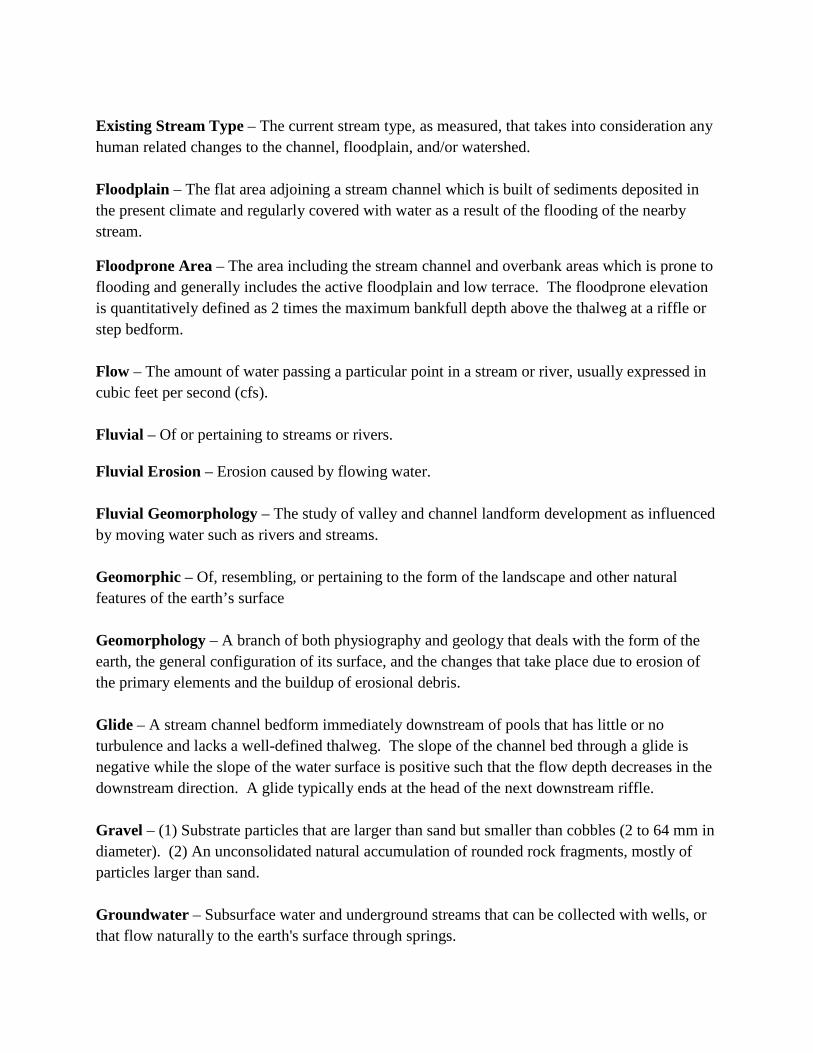
Existing Stream Type – The current stream type, as measured, that takes into consideration any human related changes to the channel, floodplain, and/or watershed. Floodplain – The flat area adjoining a stream channel which is built of sediments deposited in the present climate and regularly covered with water as a result of the flooding of the nearby stream.
Floodprone Area – The area including the stream channel and overbank areas which is prone to flooding and generally includes the active floodplain and low terrace. The floodprone elevation is quantitatively defined as 2 times the maximum bankfull depth above the thalweg at a riffle or step bedform. Flow – The amount of water passing a particular point in a stream or river, usually expressed in cubic feet per second (cfs). Fluvial – Of or pertaining to streams or rivers. Fluvial Erosion – Erosion caused by flowing water. Fluvial Geomorphology – The study of valley and channel landform development as influenced by moving water such as rivers and streams. Geomorphic – Of, resembling, or pertaining to the form of the landscape and other natural features of the earth’s surface Geomorphology – A branch of both physiography and geology that deals with the form of the earth, the general configuration of its surface, and the changes that take place due to erosion of the primary elements and the buildup of erosional debris. Glide – A stream channel bedform immediately downstream of pools that has little or no turbulence and lacks a well-defined thalweg. The slope of the channel bed through a glide is negative while the slope of the water surface is positive such that the flow depth decreases in the downstream direction. A glide typically ends at the head of the next downstream riffle. Gravel – (1) Substrate particles that are larger than sand but smaller than cobbles (2 to 64 mm in diameter). (2) An unconsolidated natural accumulation of rounded rock fragments, mostly of particles larger than sand. Groundwater – Subsurface water and underground streams that can be collected with wells, or that flow naturally to the earth's surface through springs.

Groundwater recharge – Increases in groundwater storage by natural conditions or by human activity. Groundwater table – The upper surface of the zone of saturation, except where the surface is formed by an impermeable boundary. Gradient – Vertical drop per unit of horizontal distance; slope. Habitat – The local environment in which organisms normally live and grow. Head Cut – The identifiable point of active incision where a break in grade occurs from a lower to a higher elevation. An active headcut point migrates in an upstream direction. Hydraulic gradient – The slope of the water surface. Hydrograph – A curve showing stream discharge over time. Hydrology – The scientific study of the water of the earth, its occurrence, circulation and distribution, its chemical and physical properties, and its interaction with its environment, including its relationship to living things. Hyporheic zone – The area under the stream channel and floodplain where groundwater and the surface waters of the stream are exchanged freely. Incised Channel – A river that has eroded its channel bed by the process of degradation to a lower base level than existed previously or is consistent with the current hydrology. An incised stream channel is typically disconnected from its historic floodplain such that flows significantly greater than the bankfull discharge are needed to overflow onto it. Incision Ratio – A measurement of stream channel incision. Traditionally calculated as the lowest bank height divided by the maximum bankfull depth. Per the VT Stream Geomorphic Assessment Protocols, incision ratio is calculated as the height of the recently abandoned floodplain (RAF) divided by the maximum bankfull depth. Intermittent stream – Any nonpermanent flowing drainage feature having a definable channel and evidence of scour or deposition. Large woody material – Pieces of wood at least 6 feet long and 1 foot in diameter (at the large end) contained, at least partially, within the bankfull channel.

Maximum bankfull depth – The maximum depth of flow in a channel at the bankfull discharge as measured between the thalweg and water surface. Mean bankfull depth – The average depth of flow in a channel during the bankfull discharge. Calculated as bankfull cross-sectional area divided by bankfull width. Mean velocity – The average cross-sectional velocity of water in a stream channel. Surface values typically are much higher than bottom velocities. May be approximated in the field by multiplying the surface velocity, as determined with a float, times 0.8. Meander – A curve or loop in the course of a stream channel, usually in an erodible alluvial valley, that is produced as the channel flows from side to side across its floodplain. Meander Belt Width – the distance, measured perpendicular to the fall line of the valley, between lines drawn tangential to the extreme limits of fully developed meanders. Meander Width Ratio – The ratio of the meander belt width to the bankfull width. Modified Reference Stream Type – The stream type that will evolve as a result of existing or emerging stressors, including human imposed changes to the channel, floodplain, and/or watershed. A modified reference stream type assignment recognizes that watershed land use conversion, alone or in combination with channel, valley, and/or floodplain modifications, may prohibit the evolution of the channel back to the natural reference stream type. In this case, management towards an equilibrium state that is different than the natural reference type that existed historically may be more feasible. Typically the assignment of a modified reference stream type is limited to situations were historic watershed and river corridor development is so predominant that relief of the stressors associated with such development (which in many cases would require removal of substantial amounts of infrastructure) is impractical. Perennial stream – A stream that flows continuously. Pool – A stream channel bedform that is characterized by deep, low-velocity water and a smooth surface. Reach – A section of stream that, if unaltered, would be expected to have relatively uniform physical attributes, such as confinement, cross-sectional geometry, slope, sinuosity, bed material, and bed forms. Recently Abandoned Floodplain (RAF) – A former floodplain surface (i.e. terrace) which was historically flooded during flows just greater than the bankfull discharge but, due to recent channel incision (within past 200± years), are flooded only by infrequent, large floods.

Reference Stream Type – The natural stream type that would exist in the absence of human-related changes to the channel, floodplain, and/or watershed. Given the long history of human-related landscape changes, the assignment of a reference stream type is often based largely on characteristics of the valley and geology. Regime theory – A theory of channel formation that applies to streams that make a part of their boundaries from their transported sediment load and a portion of their transported sediment load from their boundaries. Channels are considered in regime, or equilibrium, when bank erosion and bank formation are equal. Restoration – The return of an ecosystem to a close approximation of its condition prior to disturbance. Riffle – A stream channel bedform that is characterized by shallow, fast-moving water broken by the presence of rocks and boulders. Riparian – Located on the banks of a stream or other body of water. Riparian area – An area of land and vegetation adjacent to a stream that has a direct effect on the stream. This includes woodlands, vegetation, and floodplains. Riparian buffer – The width of naturally vegetated land adjacent to the stream between the top of the bank (or top of slope, depending on site characteristics) and the edge of other land uses. A buffer is largely undisturbed and consists of the trees, shrubs, groundcover plants, duff layer, and naturally uneven ground surface. The buffer serves to protect the water body from the impacts of adjacent land uses. Riparian corridor – A corridor of land defined by the lateral extent of a stream’s meanders necessary to maintain a stable stream dimension, pattern, profile, and sediment regime. The riparian corridor typically corresponds to the land area surrounding and including the stream that supports (or could support if unimpacted) a distinct ecosystem, generally with abundant and diverse plant and animal communities. Riparian habitat – The aquatic and terrestrial habitat adjacent to streams, lakes, estuaries, or other waterways. Riparian vegetation – The plants that grow adjacent to a wetland area such as a river, stream, reservoir, pond, spring, marsh, bog, meadow, etc., and that rely upon the hydrology of the associated water body.

Ripple – A specific undulated bed form found in sand bed streams. Riprap – Rock or other material with a specific mixture of sizes, referred to as a "gradation", often used to stabilize streambanks from erosion. Run – A stream channel bedform that is typically located immediately downstream of a riffle and upstream of a pool which is characterized by fast, low-turbulent flow. The bed slope and water surface slope are generally both positive in the downstream direction with the bed slope being greater. Runs will often have a well-defined thalweg. Runoff – Water originating as rainfall or snowmelt that flows over the ground and reaches a stream. Sand – Small substrate particles that are larger than silt and smaller than gravel (0.0625 to 2 mm in diameter). Scour – The erosive action of running water in streams which excavates and carries away material from the bed and banks. Sediment – Soil or mineral material transported by water or wind and deposited in streams or other bodies of water. Segment – A relatively homogenous section of stream contained within a reach that has the same reference stream characteristics but is distinct from other segments in the reach in one or more of the following parameters: degree of floodplain encroachment, presence/absence of grade controls, bankfull channel dimensions (W/D ratio, entrenchment), channel sinuosity and slope, riparian buffer and corridor conditions, abundance of springs/seeps/adjacent wetlands/stormwater inputs, and/or degree of channel alterations. Sensitivity – the likelihood that a stream will physically respond to a watershed or local disturbance or stressor. Silt – Substrate particles smaller than sand and larger than clay (0.0039 to 0.0625 mm). Sinuosity – The ratio of stream channel length (measured along the thalweg) to the valley length. Can also be expressed as the ratio of the valley slope to the channel slope.

Stream Stability – The ability of a stream to transport the water and sediment of its watershed in such a manner to maintain its dimension, pattern, and profile, over time, without either aggrading or degrading. Stream type – A designation inferring the overall physical characteristics of the channel. Several stream typing systems have been developed with the most widely used being the Rosgen Classification System (1996). Streambank armoring – Erosion resistant materials such as riprap and gabions placed along stream banks. Streambed – The unvegetated portion of a channel boundary below the baseflow level. Suspended Load –The portion of the total sediment load that is carried in the water column and is comprised of fine particle sizes including clay, silt, and fine sands. Total sediment load minus bedload. Step – A step-like stream channel bedform typically found in a high gradient streams (> 2%) and composed of large cobble and boulders across the channel over which flows cascade. Steps often control the grade (elevation) of the stream bed. Substrate – The composition of a streambed, including either mineral or organic materials. Terrace – A relatively level landform located parallel to, and above, a stream channel and its floodplain which is the remnant of an earlier floodplain which existed at a time when the stream was flowing at a higher elevation before it degraded and created a new floodplain at a lower elevation. Thalweg – A line connecting the lowest points along a streambed. The deepest point at any given cross-section. Tributary – A stream that flows into another, larger stream. Watershed – An area of land whose total surface drainage flows to a single point in a stream. Width-to-Depth Ratio – The bankfull width divided by the average bankfull depth. Low width-to-depth ratios are indicative of narrow, deep channels whereas high width-to-depth ratios are characteristic of wide, shallow streams.

Appendix B The Key to the Rosgen Classification of Natural
Rivers

Entrenchment Ratio
Width / Depth Ratio
Sinuosity
SLOPESLOPE
BEDROCK
BOULDERS
SILT / CLAY
SAND
GRAVEL
COBBLE
Slope Range Slope Range Slope Range Slope Range
>0.10
0.04 -0.099
0.02 -0.039
0.02 -0.039
<0.02 <0.02 <0.02 <.005
A1a+ G1 F1b
A2a+ G2 F2b
A3a+ G3 F3b E3b
A4a+ G4 F4b E4b
A5a+ G5 F5b E5b
A6a+ G6 F6b E6b
A1 G1c F1
A2 G2c F2
A3 G3c F3 E3
A4 G4c F4 E4 DA4
A5 G5c F5 E5 DA5
A6 G6c F6 E6 DA6
AA GG FF EE DADA
MULTIPLE CHANNELSMULTIPLE CHANNELS
MODERATELYENTRENCHED
SLIGHTLY ENTRENCHED ( Ratio > 2.2 )
Very LOWWidth/Depth ( < 12 )
MODERATE t o H IGH Width / Depth ( > 12 )
Very HIGHWidth / Depth ( > 40 )
Ratio
(1.4 - 2.2)
MODERATEWidth / Depth Ratio ( > 12 )
Slope Range Slope Range Slope Range
.04 -0.099
.02 -0.039
.02 -0.039
.001-0.02
.001-0.02
<0.02 <.001 <.001
B1 C1
B2 C2
B3 C3 D3
B4 C4 D4
B5 C5 D5
B6 C6 D6
B1c C1c-
B2c C2c-
B3c C3c-
B4c C4c- D4c-
B5c C5c- D5c-
B6c C6c- D6c-
B1a C1b
B2a C2b
B3a C3b D3b
B4a C4b D4b
B5a C5b D5b
B6a C6b D6b
BB CC DDSlope
ENTRENCHED ( Ratio < 1.4 )
SINGLE-THREAD CHANNELSSINGLE-THREAD CHANNELS
HighlyVariable
W / D R atio
ChannelChannelMaterialMaterial
MODERATE to HIGH W/D ( >12 )
LOWWidth / Depth Ratio ( < 12 )
KEY to the CLASSIFICATION of NATURAL RIVERS.ROSGENROSGEN As a function of the "continuum of physical variables" within stream
STREAM TYPESTREAM TYPE
reaches, values of Entrenchment and Sinuosity ratios can vary by +/- 0.2 units; while values for Width / Depth ratios can vary by +/- 2.0 units.
0.02 -0.039
0.02 -0.039
LOWSINUOSITY ( < 1.2 )
MODERATESINUOSITY ( > 1.2 )
MODERATESINUOSITY ( > 1.2 )
HIGHSINUOSITY ( > 1.5 )
MODERATE to H IG HSINUOSITY
( > 1.2 )
Very LOWSINUOSITY
MODERATESINUOSITY ( > 1.2 )
HighlyVariableSinuosity
ã Wildland Hydrology 1481 Stevens Lake Road Pagosa Springs, CO 81147 ( 970) 731-6100 e-mail: [email protected]
The Key to the Rosgen Classification of Natural Rivers

ENTRENCHED Entrenchment Ratio = 1.0 - l.4
STREAM1YPE
~-j)~ik~;;;ittl STREAM'IYPE
F
il;;~i~;~;;~; ;~~¥1~11
Moderately ENTRENCHED
Entrenchment Ratio= 1.41 - 2.2
STREAM'IYPE
B
- - - -------- -- - - ....
~IM1~.&iiMJ£\ti~dl~iji STREAM1YPE
B
ENTRENCHMENT RATIO
Slightly ENTRENCHED
Entrenchment Ratio • 2 .2 +
STREAM1YPE
c ~ - - - - - - - - - - - - - - ~:·::~·.:
18t!~t~kJH!r;g .. ;t~t~~ STREAM1YPE
D
STREAM'IYPE
E
- - - - _Fw_o!>:.l'gQ.N]!: ~I!ro - - - ~.:;:. -;·;- ~.·.-~.~--.:·.~_r.:_f_:_(;·_=.: .. _~.:-,~_:i:_f_:.:;;~_._~_;·;·:,:~.·,:_-~.~.~ .. : __ ::.:.'_._~_ .• ;.~_ .. ·.~-~-~.p_:·~. ·-·.'···.:.:. _ .. '_ .. :.·.-.:.-~· .... ':.·.~.-.!~_;_'._,_; .. i .. ,~;f~t.:i.:_:~.-~.:_; .. _:_i.J,:;.:_(_~_l . _ . -.~=:!!f;.i)~'.~m~;mt'.~,_ ___ -___ · __ . __ , __ ._. __ -_· ___ ·_-_-___ -_,-
ENTRENCHMENT RATIO = FLOOD-PRONE WIDTH BANKFULL WIDTH
FLOOD-PRONE WIDTH • WATER LEVEL @ 2 x Max. Depth
FIGURE 5-10. Representative entrenchment ratios for cross-sections of various stream types.

STREAM TYPES
LONGITUDINAL, CROSS-SECTIONAL and PLAN VIEWS of MAJOR STREAM TYPES
c - - - - - - - D ---- - -- - DA E F <2% <0.5% <4%
<:2% <2%

Appendix C Stream Segment Photos

Photos of each stream segment are shown below:
View downstream from I-293 culvert outlet at mass wasting of left bank/valley wall. M01A 8-9-12
View downstream within segment M01A at cross-section location and mass wasting of left bank/valley wall. 8-11-12
View upstream at segment M01B from inlet of I-293 culvert. 4-25-12
View downstream at mass wasting along right bank/valley wall within segment M01B. 8-11-12

View downstream at reach 1-2 break and upper portion of segment M01C. 4-25-12
View downstream at cross-section location within segment M01C. 8-11-12
View downstream at cross-section location within segment M02A. 8-11-12
View downstream at mass wasting along right bank/valley wall within segment M02A. 8-11-12

View upstream at cross-section location within segment M02B. 8-11-12
View downstream from Eastman Avenue at segment M02B. 4-25-12
View downstream at upper portion of segment M02B from outlet of Second Street culvert. 4-25-12
View downstream at portion of segment M02C adjacent to parking lot. 4-25-12

View downstream in M02C showing minimal buffer between top of bank and edge of pavement. 8-10-12
View upstream at cross-section location in segment M02D. Note very dense vegetation characteristic of this segment. 8-10-12
View upstream at sediment deposit in segment M02D. 8-10-12
View upstream at flood chute in segment M02D. 8-10-12

View downstream at outflanked end of South Main Street Dam and eroding left bank. 8-10-12
View upstream at outlet of a 66” diameter culvert under South Main Street at the upstream end of segment M03B and SGA study area. 8-10-12
View upstream at sediment deposit and cross-section location within segment M03A. 8-10-12
View upstream at segment M03B. 8-10-12

Appendix D Stressor Identification Maps

LOC
AT
ION
MA
P
MCQ
UEST
EN B
ROO
K G
EOM
ORP
HIC
ASSE
SSM
ENT
STRE
SSO
R AN
D DE
PATU
RE M
APS
HIL
LSB
OR
OU
GH
CO
UN
TY,
NH
DATE:
DESIGNED BY:
DRAWN BY:
CHECKED BY:
PROJECT NO:
FIGURE NUMBER
03/2013
GDF
SAS
E12-01
1 OF 10
-
County Boundaries
Town Boundaries
MCQUESTEN BROOK STUDY AREA
TextSTUDY AREA
MCQUESTEN BROOK STUDY AREA
MCQUESTEN BROOK STUDY REACH
Town Boundaries
.
0 10.5 Miles
BEDFORD
MANCHESTER
GEOFFSTOWN

[�
[�[�
[�[�
[�
[�[�
M03B
M03AM02D
M02C
M02B
M02A
M01C
M01B
M01A
Bedford
Manchester
WETLAND LOST COMPLETED BYCOMPARING NATIONAL WETLANDINVENTORY TO LAND USE TO DETERMINE PARTIAL OR FULL DISTURBANCEFROM AGRICULTURE OR DEVELOPMENTALL WETLANDS HAD AT LEAST PARTIALDISTURBANCE
HY
DR
OL
OG
IC A
LT
ER
AT
ION
S M
AP
MC
QU
ES
TE
N B
RO
OK
GE
OM
OR
PH
IC A
SS
ES
SM
EN
T
ST
RE
SS
OR
AN
D D
EP
AT
UR
E M
AP
S
HIL
LS
BO
RO
UG
H C
OU
NT
Y,
NH
DATE:
DESIGNED BY:
DRAWN BY:
CHECKED BY:
PROJECT NO:
FIGURE NUMBER
03/2013
GDF
SAS
E12-01
2 OF 10
-
.
.Legend
[� Stormwater Inputs
Roads
Reach or Segment Breaks
Wetland Loss
Town Boundaries
Stormwater Input Per Reach
<=2
>2<=5
>5
Road Density
0-1 mi/sqmi
1-3 mi/sqmi
>3 mi/sqmi
0 1,000 2,000500Feet
Legend
ReachPoints
Reach Or Segment Breaks
Mcquesten Brook Study Area
Wetland Loss
Roads Road Density
0-1 mi/sqmi
1-3 mi/sqmi
>3 mi/sqmi
0 1,000 2,000500 Feet
STUDY AREASTUDY AREA

MER
RIM
AC
K R
IVER
M03B
M03A M02D
M02C
M02B
M02A
M01C
M01B
M01A
LAND COVER DATE FROM 2001 GRANIT DATABASES
LAN
D C
OV
ER
MA
P
MCQ
UEST
EN B
ROO
K G
EOM
ORP
HIC
ASSE
SSM
ENT
STRE
SSO
R AN
D DE
PATU
RE M
APS
HIL
LSB
OR
OU
GH
CO
UN
TY,
NH
DATE:
DESIGNED BY:
DRAWN BY:
CHECKED BY:
PROJECT NO:
FIGURE NUMBER
03/2013
GDF
SAS
E12-01
3 of 10
-
REACH OR SEGMENT BREAKS
MCQUESTEN BROOK STUDY AREA
MCQUESTEN BROOK STUDY REACHES
DEVELOPMENT
AGRICULTURE
FORESTED
OPEN WATER
WETLAND
OTHER CLEARED LAND
.
0 10.5Miles
.

!
!
!
!
!
!
#*
#*
M03B
M03A
M02D
M02C
M02B
M02A
M01C
M01B
M01A
SE
DIM
EN
T L
OA
D I
ND
ICA
TO
RS
MA
P
MC
QU
ES
TE
N B
RO
OK
GE
OM
OR
PH
IC A
SS
ES
SM
EN
T
ST
RE
SS
OR
AN
D D
EP
AT
UR
E M
AP
S
HIL
LS
BO
RO
UG
H C
OU
NT
Y,
NH
DATE:
DESIGNED BY:
DRAWN BY:
CHECKED BY:
PROJECT NO:
FIGURE NUMBER
03/2013
GDF
SAS
E12-01
4 of 10
-
..
Legend
#* Flood Chutes
Reach or Segment Breaks
Roads
Mass Wasting
! ! Left Bank
! !Right Bank
Eroding Banks
Left Bank
Right Bank
Depositional Features/Mile
0-5
6-10
>10
Subwatershed Percent Agriculture
Low (0.00%- 5.00%)
Mod (5.01% - 10.00%)
High (10.01% - 20.00%)
0 1,000500Feet
Legend
Reach Or Segment Breaks
Mcquesten Brook Study Area
Subwatershed Percent Agriculture
Low (0.00%- 5.00%)
Mod (5.01% - 10.00%)
High (10.01% - 20.00%)
0 1,000 2,000500 Feet
STUDY AREASTUDY AREA

"/
"/
"/
"/
M03B
M03A
M02D
M02C
M02B
M02A
M01C
M01B
M01A
CH
AN
NE
L S
LOP
E M
OD
IFE
RS
MA
P
MCQ
UEST
EN B
ROO
K G
EOM
ORP
HIC
ASSE
SSM
ENT
STRE
SSO
R AN
D DE
PATU
RE M
APS
HIL
LSB
OR
OU
GH
CO
UN
TY,
NH
DATE:
DESIGNED BY:
DRAWN BY:
CHECKED BY:
PROJECT NO:
FIGURE NUMBER
03/2013
GDF
SAS
E12-01
5 of 10
-
.Slope Decreases
"/ Culverts
Grade Control
0 1,000500Feet
Slope Increases
Road Enchroachment Straightening Developmentleftright
Reach or Segment BreaksMcquesten BrookRoadsWatershed Boundaries
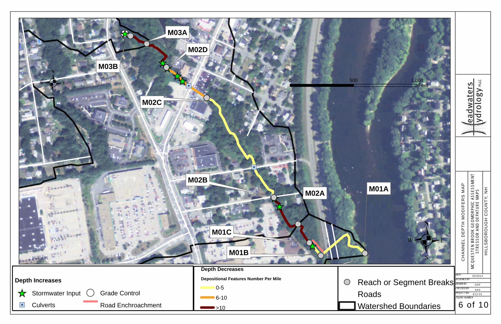
"/
"/
"/
"/
[_
[_[_
[_[_
[_
[_[_
M03B
M03A
M02D
M02C
M02B
M02A
M01C
M01B
M01A
CH
AN
NE
L D
EP
TH
MO
DIF
ER
S M
AP
MCQ
UEST
EN B
ROO
K G
EOM
ORP
HIC
ASSE
SSM
ENT
STRE
SSO
R AN
D DE
PATU
RE M
APS
HIL
LSB
OR
OU
GH
CO
UN
TY,
NH
DATE:
DESIGNED BY:
DRAWN BY:
CHECKED BY:
PROJECT NO:
FIGURE NUMBER
03/2013
GDF
SAS
E12-01
6 of 10
-
.
.Depth Increases
[_ Stormwater Input
"/ Culverts
Grade Control
Road Enchroachment
0 1,000500Feet
Depth Decreases
Depositional Features Number Per Mile
0-5
6-10
>10
Reach or Segment BreaksRoadsWatershed Boundaries

"/
"/
"/
"/
M03B
M03A
M02D
M02C
M02B
M02A
M01C
M01B
M01A
BO
UN
DA
RY
CO
ND
ITIO
N
AN
D R
IPA
RIA
N M
OD
IFE
RS
MA
P
MCQ
UEST
EN B
ROO
K G
EOM
ORP
HIC
ASSE
SSM
ENT
STRE
SSO
R AN
D DE
PATU
RE M
APS
HIL
LSB
OR
OU
GH
CO
UN
TY,
NH
DATE:
DESIGNED BY:
DRAWN BY:
CHECKED BY:
PROJECT NO:
FIGURE NUMBER
03/2013
GDF
SAS
E12-01
7 of 10
-
.
0 1,000500Feet
LegendReach or Segment Breaks
"/ Culverts
Grade Control
Buffers <25ft
Coarse Bed
Left Bank Armoring
Right Bank Armoring
Left Eroding Bank
Right Eroding Bank
Mcquesten Brook

M03B
M03A
M02D
M02C
M02B
M02A
M01C
M01B
M01A
SE
DIM
EN
T R
EF
ER
EN
CE
RE
GIM
E M
AP
MCQ
UEST
EN B
ROO
K G
EOM
ORP
HIC
ASSE
SSM
ENT
STRE
SSO
R AN
D DE
PATU
RE M
APS
HIL
LSB
OR
OU
GH
CO
UN
TY,
NH
DATE:
DESIGNED BY:
DRAWN BY:
CHECKED BY:
PROJECT NO:
FIGURE NUMBER
03/2013
GDF
SAS
E12-01
8 of 10
-
.0 1,000500
Feet
LegendReach or Segment Breaks
Subwatershed Boundaries
Roads
TRANSPORT
CONFINDED SOURCE AND TRANSPORTUNCONFINDED SOURCE AND TRANSPORT
FINE SOURCE & TRANSPORT & COURSE DEPOSITION
COARSE EQUILIBRIUM & FINE DEPOSITIONDEPOSITION
REFERENCE SEDIMENT REGIME

M03B
M03A
M02D
M02C
M02B
M02A
M01C
M01B
M01A
SE
DIM
EN
T E
XIS
ITN
G
CO
ND
ITIO
NS
RE
GIM
E M
AP
MCQ
UEST
EN B
ROO
K G
EOM
ORP
HIC
ASSE
SSM
ENT
STRE
SSO
R AN
D DE
PATU
RE M
APS
HIL
LSB
OR
OU
GH
CO
UN
TY,
NH
DATE:
DESIGNED BY:
DRAWN BY:
CHECKED BY:
PROJECT NO:
FIGURE NUMBER
03/2013
GDF
SAS
E12-01
9 of 10
-
.0 1,000500
Feet
LegendReach or Segment Breaks
Roads
Subwatershed Boundaries
Roads Buffer
TRANSPORTCONFINDED SOURCE AND TRANSPORT
UNCONFINDED SOURCE AND TRANSPORT
FINE SOURCE & TRANSPORT & COURSE DEPOSITION
COARSE EQUILIBRIUM & FINE DEPOSITION
DEPOSITION
EXISTING SEDIMENT REGIME

DD DDDD DD
DD
DD
DDDD
DDDD
DD DDDD
M03B
M03A
M02D
M02C
M02B
M02A
M01C
M01B
M01A
ST
EA
M C
HA
NN
EL
SE
NS
ITIV
ITIE
S
MCQ
UEST
EN B
ROO
K G
EOM
ORP
HIC
ASSE
SSM
ENT
STRE
SSO
R AN
D DE
PATU
RE M
APS
HIL
LSB
OR
OU
GH
CO
UN
TY,
NH
DATE:
DESIGNED BY:
DRAWN BY:
CHECKED BY:
PROJECT NO:
FIGURE NUMBER
03/2013
GDF
SAS
E12-01
10 of 10
-
.0 1,000500
Feet
LegendRoads
Subwatershed Boundaries
CURRENT ADJUSTMENT PROCESSçççççççççççççççççççççççççççççççççç Widening
DD DD DD Widening, Aggradation and Planform
Stream SensitivityVery High
High
Moderate
çççççççççççççççççççççççççç çççç çççççççççççççççççç

R
R
R
B
D
C
B
C
B
FE
H R
AT
ING
MA
P
MCQ
UEST
EN B
ROO
K G
EOM
ORP
HIC
ASSE
SSM
ENT
STRE
SSO
R AN
D DE
PATU
RE M
APS
HIL
LSB
OR
OU
GH
CO
UN
TY,
NH
DATE:
DESIGNED BY:
DRAWN BY:
CHECKED BY:
PROJECT NO:
FIGURE NUMBER
03/2013
GDF
SAS
E12-01
-
-
.0 1,000500Feet
LegendSegment Break
Reach Break
Valley_Walls
FEH RatingVery High
High
Moderate

Appendix E Culvert Photos

Photos of each culvert are shown below:
View upstream at I-293 culvert outlet showing outlet drop & undermined headwall. 8-11-12
View downstream at I-293 culvert inlet showing debris jam. 8-9-12
View upstream at Wathen Road culvert outlet. 4-25-12
View downstream at Wathen Road culvert inlet. 4-25-12
View upstream at backwatered outlet of Eastman Avenue culvert. 8-9-12
View downstream at backwatered inlet of Eastman Avenue culvert. 8-9-12
[Type text]

View upstream at backwatered/sedimented outlet of Second Street culvert . 8-9-12
View downstream at backwatered/sedimented inlet of Second Street culvert. 8-9-12
[Type text]

Appendix F Restoration Options Evaluation for Stream
Segments

Restoration Options Evaluation for Stream Segments The feasibilities and benefits have been color-coded as follows. • Green: Not applicable, not feasible, or no benefit • Blue: Low feasibility or low benefit • Yellow: Moderate feasibility or low benefit • Orange: High feasibility or high benefit • Red: Very high feasibility or very high benefit

Restoration Options for Segment M01A
Segment Restoration Option Feasibility Benefit
M01A Protect Stream Corridor
Low feasibility. Likelihood for securing conservation easement is low as stream corridor is currently within state right-of-way and NHDOT is unlikely to constrain future interstate projects.
High at both the reach and watershed scales as there are currently no protections – brook is not within FEMA Special Flood Hazard Area (SFHA) and there are no local (Bedford) land use regulations requiring development setbacks from streams (50’ structure setback applies to vegetated wetlands only). Corridor protection would provide area for stream to adjust to equilibrium condition, thus reducing conflicts with human-constructed infrastructure and the supply of sediment delivered to the Merrimack River.
M01A Plant Stream Buffer
Not feasible. Buffers are currently forested and panting additional vegetation is not feasible due to channel widening/mass wasting.
None
M01A Stabilize Stream Banks
Not feasible. Stream segment is currently not near equilibrium condition.
None
M01A Arrest Head Cuts
Not applicable. No head cuts present. None
M01A Remove Berms
Not applicable. No berms present. None
M01A Remove or Replace Structures
Moderate feasibility of replacing I-293 culvert due to cost associated with pipe length, deep fills, and disturbance of interstate. Also, existing culvert appears to be in good structural condition (except for outlet headwall) with many years of service remaining. A more feasible alternative, for restoring AOP only, may involve creating a step-pool stream below the outlet in segment M01A (to eliminate perch and backwater the pipe) and retrofit the existing culvert with baffles or weirs to reduce velocity and trap sediment.
Very high benefit at both the reach and watershed scales. I-293 culvert is highest ranked culvert replacement. Restoring AOP through the I-293culvert would connect the Merrimack River to the entire length of McQuesten Brook downstream from S. Main St. Replacing culvert with a larger structure would reduce potential for debris jams at inlet and overtopping/washout of interstate.
M01A Restore Incised Reach
Low feasibility. Approach would likely involve restoring reference B-type stream via raising bed with grade control structures.
Moderate benefit from the reduction of channel widening, erosion, and delivery of sediment to the Merrimack River.
Moderate feasibility of creating step-pool channel just below I-293 culvert to eliminate outlet drop for AOP if culvert is not to be replaced in near future.
Very high benefit from restoring AOP through the I-293culvert as this would connect the Merrimack River to the entire length of McQuesten Brook downstream from S. Main St.
M01A Restore Aggraded Reach
Not applicable. Stream segment is not aggrading.
None

Restoration Options for Segment M01B
Segment Restoration Option Feasibility Benefit
M01B Protect Stream Corridor
Low feasibility for conservation easement as stream corridor is already developed and channel is artificially constrained (armored).
High at both the reach and watershed scales as there are currently no protections (brook is not within FEMA SFHA and no local regulations aimed at protecting the stream corridor exist). Corridor protection would reduce future conflicts with human-constructed infrastructure and possibly provide area for stream to adjust to equilibrium or “modified” reference conditions.
M01B Plant Stream Buffer
Moderate feasibility. Streambanks above riprap are currently wooded for the most part. Additional plantings of shade tolerant trees and shrubs could be placed at mast wasting site and along lower banks.
Moderate benefit from stabilizing failed slope.
M01B Stabilize Stream Banks
Not feasible. Stream segment is currently not near equilibrium or “modified” reference condition.
None
M01B Arrest Head Cuts
Not applicable. No head cuts present. None
M01B Remove Berms
Not applicable. No berms present. None
M01B Remove or Replace Structures
Not applicable. No structures present. None
M01B Restore Incised Reach
Moderate feasibility. Approach would likely involve restoring reference B-type stream via raising bed with grade control structures rather than excavating/grading the high banks, which would affect adjacent development and the interstate. The restoration work would need to be designed such that it did not cause excessive upstream aggradation.
Low benefit as the channel is currently a transport reach and not supplying significant amounts of sediment to the stream and the restored B-type stream would also be a transport reach.
M01B Restore Aggraded Reach
Not applicable. Stream segment is not aggrading.
None

Restoration Options for Segment M01C
Segment Restoration Option Feasibility Benefit
M01C
Protect Stream Corridor
High feasibility for conservation easement as stream corridor is largely undeveloped and channel near equilibrium condition.
High at both the reach and watershed scales as there are currently no protections (brook is not within FEMA SFHA and no local regulations aimed at protecting the stream corridor exist). Corridor protection would reduce future conflicts with human-constructed infrastructure and allow the stream to remain at or near equilibrium condition.
M01C Plant Stream Buffer
Not feasible. Streambanks and buffers are currently well vegetated (forested).
None
M01C Stabilize Stream Banks
Not applicable. No bank erosion present. None
M01C Arrest Head Cuts
Not applicable. No head cuts present. None
M01C Remove Berms
Not applicable. No berms present. None
M01C Remove or Replace Structures
Not applicable. No structures present. None
M01C Restore Incised Reach
Not applicable. Stream segment is not incised. None
M01C Restore Aggraded Reach
Not applicable. Stream segment is not aggrading.
None

Restoration Options for Segment M02A
Segment Restoration Option Feasibility Benefit
M02A Protect Stream Corridor
High feasibility for conservation easement as stream corridor is largely undeveloped and, given the time and space, the channel could evolve to equilibrium condition.
Very high at both the reach and watershed scales as there are currently no protections – brook is not within FEMA SFHA, there are no local (Bedford) land use regulations requiring development setbacks from streams (50’ structure setback applies to vegetated wetlands only), and channel is bordered by upland terraces which could be developed. Corridor protection would provide area for stream to adjust to equilibrium condition and thereby revert from a source/transport stream to a valuable storage segment. Protection would also reduce conflicts with human-constructed infrastructure and the supply of sediment delivered to reach M01and the Merrimack River.
M02A Plant Stream Buffer
Moderate feasibility. Streambanks and buffers are currently forested for the most part. Additional plantings of shade tolerant trees and shrubs could be placed at mass wasting/bank erosion sites along the right bank/valley wall.
Moderate benefit from stabilizing eroding banks and slopes.
M02A Stabilize Stream Banks
Moderate feasibility. Stream segment is currently not near equilibrium condition, though stabilization of eroding right bank/valley wall could occur.
Moderate benefit from stabilizing eroding banks and slope.
M02A Arrest Head Cuts
Not applicable. No head cuts present. None
M02A Remove Berms
Not applicable. No berms present. None
M02A Remove or Replace Structures
Not applicable. No structures present (Wathen Road culvert mapped in segment M02B).
None
M02A Restore Incised Reach
High feasibility for passive restoration via corridor protection which would allow channel to reestablish equilibrium utilizing its own energy and watershed inputs. Channel is no longer actively incising, but is evolving toward equilibrium via lateral erosion, aggradation, and planform changes (i.e. late stage III/early stage IV).
High at both the reach and watershed scales. Restoration would allow the channel to revert from a source/transport stream to its reference condition as a valuable flood/sediment storage segment.
M02A Restore Aggraded Reach
High feasibility for passive restoration via corridor protection which would allow channel to reestablish equilibrium utilizing its own energy and watershed inputs. Channel is actively evolving toward equilibrium via lateral erosion, aggradation, and planform changes (i.e. late stage III/early stage IV).
High at both the reach and watershed scales. Restoration would allow the channel to revert from a source/transport stream to its reference condition as a valuable flood/sediment storage segment.

Restoration Options for Segment M02B
Segment Restoration Option Feasibility Benefit
M02B Protect Stream Corridor
High feasibility for conservation easement as stream corridor is largely undeveloped. Stream segment lies in both Bedford and Manchester.
Very high at both the reach and watershed scales as this is a highly valuable flow/sediment attenuation segment in equilibrium condition downstream from converted source/transport reach and large impervious area which adversely affects watershed hydrology and water quality. There are currently limited protections. The brook is not within FEMA SFHA and therefore local floodplain management regulations do not apply. Vegetated wetlands border the stream throughout the segment, and both Bedford and Manchester zoning regulations include minimum setbacks to wetlands (25’ from structures & parking lots in Manchester and 50’ from structures in Bedford). State wetland regulations also provide some de facto protection, though permits for disturbances could potentially be secured. Corridor protection via easement would eliminate reliance on other regulations which do not specifically protect geomorphic processes or in-stream habitat and could be circumvented.
M02B Plant Stream Buffer
Not feasible. Streambanks and buffers are currently well vegetated with trees, shrubs, and herbs.
None
M02B Stabilize Stream Banks
Not applicable. No bank erosion present. None
M02B Arrest Head Cuts
Not applicable. No head cuts present. None
M02B Remove Berms
Not applicable. No berms present. None
M02B Remove or Replace Structures
High feasibility for replacing both the Wathen Road and Eastman Ave. culverts.
Very high benefit to AOP would result from replacing both culverts with larger structures designed to simulate natural stream conditions. Wathen Road culvert is ranked second for replacement and Eastman Ave. culvert is ranked third. Replacements would also improve geomorphic compatibility thereby reducing potential for roadway flooding or washouts.
M02B Restore Incised Reach
Not applicable. Stream segment is not incised.
None
M02B Restore Aggraded Reach
Not applicable. Stream segment is not aggrading.
None

Restoration Options for Segment M02C
Segment Restoration Option Feasibility Benefit
M02C
Protect Stream Corridor
Low feasibility for easement as stream corridor is already developed and channel artificially constrained via parking lot along left bank upstream from Second Street.
High at both the reach and watershed scales as there are currently no protections (brook is not within FEMA SFHA and no local regulations aimed at protecting the stream corridor exist). Corridor protection would possibly provide area for stream to adjust to “modified” reference conditions.
M02C Plant Stream Buffer
Moderate feasibility. Right bank/valley wall upstream from Second Street is densely covered with Japanese knotweed. Face of left bank and small strip of land between top of bank and edge of pavement could be planted with live stakes, tubelings, or small containerized shrubs.
Moderate benefit from improving stability of left bank along parking lot.
M02C Stabilize Stream Banks
Moderate feasibility. Stability of left bank along parking lot could be improved by planting live stakes, tubelings, or small containerized shrubs.
Moderate benefit from improving stability of left bank along parking lot.
M02C Arrest Head Cuts
Not applicable. No head cuts present. None
M02C Remove Berms
Not applicable. No berms present. None
M02C Remove or Replace Structures
Moderate feasibility of replacing Second Street culvert due to cost associated with pipe length, deep fills, and disturbance of Second Street, which is a major transportation route.
Moderate benefit as existing culvert is ranked “Mostly Compatible” for geomorphic compatibility and provides some AOP as it is backwatered along its entire length with substrate >3’ thick on culvert bottom throughout,
M02C Restore Incised Reach
Low feasibility as restoration would require removal of a portion of the parking lot along left bank upstream from Second Street.
Moderate benefit as banks are not actively eroding and restoration would likely involve creating “modified” reference conditions (Bc stream type) which would still be a transport stream.
M02C Restore Aggraded Reach
Not applicable. Stream segment is not aggrading.
None

Restoration Options for Segment M02D
Segment Restoration Option Feasibility Benefit
M02D Protect Stream Corridor
High feasibility for conservation easement as stream corridor is largely undeveloped.
Very high at both the reach and watershed scales as this is a highly valuable flow/sediment attenuation segment in equilibrium condition downstream from eroding/aggrading source/transport segment and large impervious area which adversely affects watershed hydrology and water quality. There are currently limited protections. The brook is not within FEMA SFHA and therefore local floodplain management regulations do not apply. Vegetated wetlands border the stream throughout the segment and Manchester zoning regulations include minimum setbacks to wetlands (25’ from structures & parking lots). State wetland regulations also provide some de facto protection, though permits for disturbances could potentially be secured. Corridor protection via easement would eliminate reliance on other regulations which do not specifically protect geomorphic processes or in-stream habitat and could be circumvented.
M02D Plant Stream Buffer
Not feasible. Streambanks and buffers are currently well vegetated with trees, shrubs, and herbs.
None
M02D Stabilize Stream Banks
Not applicable. No bank erosion present. None
M02D Arrest Head Cuts
Not applicable. No head cuts present. None
M02D Remove Berms
Not applicable. No berms present. None
M02D Remove or Replace Structures
Not applicable. No structures present. None
M02D Restore Incised Reach
Not applicable. Stream segment is not incised.
None
M02D Restore Aggraded Reach
Not applicable. Stream segment is not aggrading.
None

Restoration Options for Segment M03A
Segment Restoration Option Feasibility Benefit
M03A Protect Stream Corridor
High feasibility for conservation easement as stream corridor is largely undeveloped and, given time and space, the channel could evolve to equilibrium condition.
High at both the reach and watershed scales as there are currently no protections – brook is not within FEMA SFHA, there are no local (Manchester) land use regulations requiring development setbacks from streams (25’ structure setback applies to vegetated wetlands only), and channel is bordered by upland terraces which could be developed. Corridor protection would provide area for stream to adjust to equilibrium condition.
M03A Plant Stream Buffer
Not feasible. Buffers are currently forested and panting additional vegetation is not feasible due to channel widening/bank erosion.
None
M03A Stabilize Stream Banks
Not feasible as stream segment is currently not near equilibrium condition.
None
M03A Arrest Head Cuts
Not applicable. No head cuts present. None
M03A Remove Berms
Low feasibility. Channel in this segment is not natural and was constructed with a straight alignment and excavated material placed along left bank to create artificial valley wall (berm considered valley wall under SGA). Removal of fill would require significant land disturbance and removal of semi-mature forest.
High benefit. Removal of artificial valley wall would change valley type to unconfined and allowing stream to evolve to equilibrium conditions as a valuable flow/sediment storage segment.
M03A Remove or Replace Structures
High feasibility of removing dilapidated concrete dam (South Main Street Dam) which has been outflanked and is causing accelerated left bank erosion.
Moderate benefit reducing rate of bank erosion.
M03A Restore Incised Reach
High feasibility for passive restoration via corridor protection which would allow channel to reestablish equilibrium utilizing its own energy and watershed inputs. Channel is no longer actively incising, but is evolving toward equilibrium via lateral erosion, aggradation, and planform changes (i.e. late stage III/early stage IV).
High at both the reach and watershed scales. Depending upon final equilibrium morphology, restoration could allow the channel to revert from a source/transport stream to reference condition as a valuable flood/sediment storage segment.
M03A Restore Aggraded Reach
High feasibility for passive restoration via corridor protection which would allow channel to reestablish equilibrium utilizing its own energy and watershed inputs. Channel is actively evolving toward equilibrium via lateral erosion, aggradation, and planform changes (i.e. late stage III/early stage IV).
High at both the reach and watershed scales. Depending upon final equilibrium morphology, restoration could allow the channel to revert from a source/transport stream to reference condition as a valuable flood/sediment storage segment.

Restoration Options for Segment M03B
Segment Restoration Option Feasibility Benefit
M03B
Protect Stream Corridor
Low feasibility for conservation easement as channel is artificially constrained (armored/paved with concrete).
Low benefit as, due to armoring, corridor protection would have no influence on future channel evolution.
M03B Plant Stream Buffer
Not feasible. Streambanks above bank armor are currently wooded.
None
M03B Stabilize Stream Banks
Not applicable. No active bank erosion, stream segment is currently armored.
None
M03B Arrest Head Cuts
Not applicable. No head cuts present. None
M03B Remove Berms
Not applicable. No berms present. None
M03B Remove or Replace Structures
Not applicable. No structures present. None
M03B Restore Incised Reach
Low feasibility due to existing bed and bank armor.
Low benefit as currently the channel is a transport reach and restored stream would also be a transport reach. Also, due to very long segment of culverted stream (3,200’) immediately upstream from this segment, restoring stream for AOP would not provide access to stream beyond the segment.
M03B Restore Aggraded Reach
Not applicable. Stream segment is not aggrading.
None

Appendix C McQuesten Sampling Results

McQuesten Brook and Pond Sampling Station DescriptionsSTATIONID STATNAME TOWN STATTYPE DATEEST WATERBODYID STATDESCR LATDECDEG LONGDECDEG DATELOC ELEV
01-MQB RIVERWAY PLACE CULVERT BEDFORD CULVERT 20-Jul-12 NHRIV700060803-16
36" CULVERT FROM UNDER MEDICAL PARK (BEHIND T-BONES PLAZA) NORTH EAST CORNER OF BACK LOT DOWN HILLFROM P-LOT. CULVERT OUTFALLS INTO MQUESTON BROOK~ 100 FEET UPSTREAM FROM LOCATION WHERE MCQUESTON BROOKS ENTERS CULVERT THAT PASSES UNDER ROUTE 3A/EVERETT TURNPIKE.
42.9637 -71.47699 20-Jul-12 464
02-MQB
50 FEET DOWNSTREAM
OF WATHEN ROAD CULVERT
BEDFORD RIVER/STREAM 12-Jul-10 NHRIV700060803-16
50 FEET DOWNSTREAM OF WATHEN ROAD CULVERT CROSSING. ANIMAL PENS ALONG RIVER LEFT WITH STEEP BANKS ALONG RIVER RIGHT
42.964738 -71.47799 12-Jul-10 100
03-MQB MCQUESTEN POND-OUTLET MANCHESTER RIVER/STREAM NHRIV700060803-16
ALTHOUGH LISTED AS MCQUESTEN POND OUTLET, THIS IS MCQUESTEN BROOK MAINSTEM IMMEDIATELY DOWNSTREAM OF WHERE THE OUTLET CHANNEL OF MCQUESTEN BROOK JOINS IT WHEN FLOW IS PRESENT. THIS STATION IS LOCATED IN THE CORNER OF THE MARTEL REALTY AGENCY LOT BEHIND THE BUILDING
42.9689 -71.481278 31-Jul-01 138
03D-MQB HALE ROAD CULVERT MANCHESTER CULVERT 5-Jul-11 NHRIV700060803-16
CULVERT AND HEADWALL THAT DRAINS HALE ROAD SUBWATERSHED AREA. ABUNDANT FE BACTERIA IN PLUNGE POOL AT OUTLET OF CULVERT WITH PETROLUEM ODORS PRESENT.
42.967437 -71.481474 30-Jun-11
04-MQB MCQUESTEN POND-DEEP SPOT MANCHESTER LAKE/POND NHLAK700060803-03
"DEEP SPOT" ON MCQUESTEN POND LOCATED AT GRANITE BLOCKS WHERE MCQUESTEN POND NARROWS UP BEHIND FITNESS CLUB.
42.9692 -71.481278 5-Jan-04 138
05-MQB
MCQUESTEN POND-INLET/50'
D/S FROM OUTLET OF S.MAIN ST
MANCHESTER RIVER/STREAM 12-Jul-10 NHRIV700060803-16
5 FOOT DIAMETER CULVERT AND CONCRETE HEADWALL WITH GATE UNDER SOUTH MAIN STREET WITH CONCRETE SLUICEWAY. THERE IS A CONCRETE DAM STRUCTURE IMMEDIATELY DOWNSTREAM OF THE POOL THAT THE SLUICEWAY CREATES
42.968673 -71.482925 31-Jul-01 138

McQuesten Brook Water Quality Data
STATION_ID DateChloride
(mg/l)
Chlorophyll-a, Uncorrected for
Pheophytin (ug/l)DO
(mg/l)
DO Saturation
(%) pHPhosphorus
(mg/l)
Specific Conductance
(umho/cm)Temp
(deg C)Turbidity
(NTU)01-MQB 08/17/2012 7.56 83.9 6.85 1364 20 0.9101-MQB 07/20/2012 7.34 79.2 6.83 1557 18.8 1.2102-MQB 06/15/2012 8.27 79.3 6.75 502 13.7 3.0902-MQB 08/17/2012 7.82 79.9 6.67 508 16.4 2.2402-MQB 07/20/2012 8.23 82.7 6.76 548 15.6 2.3503D-MQB 06/15/2012 5.32 57 6.91 1527 16.5 9.6303D-MQB 08/17/2012 5.8 64.3 6.77 1136 20.3 5.1803D-MQB 07/20/2012 7.63 79.6 7.05 1672 17.1 3.7703D-MQB 07/26/2011 470 4.9 52 6.66 1501 16.9 6.6603D-MQB 08/30/2011 560 5.33 57.9 6.56 1633 18.8 6.6203-MQB 06/15/2012 7.44 79.7 6.56 471 14 4.0903-MQB 06/15/2012 8.16 79 6.56 472.2 14 3.2703-MQB 08/17/2012 7.71 79.3 6.33 481.7 16.4 2.3903-MQB 07/20/2012 8.04 80.9 6.6 516 15.6 2.2203-MQB 06/30/2011 170 8.47 86.4 6.78 548 16.5 1.903-MQB 06/30/2011 6.5 8.65 89.2 6.8 548 16.6 1.6903-MQB 07/26/2011 160 8.6 88.2 6.41 557 16.4 3.903-MQB 08/30/2011 160 7.35 79.2 6.36 510 18.7 2.9603-MQB 06/07/2000 7.24 0.059 372 2.603-MQB 07/31/2000 6.79 0.037 416 2.403-MQB 09/13/2000 7.09 0.109 514 6.503-MQB 10/03/2000 7.28 0.097 553 7.203-MQB 05/31/2001 7.07 0.028 529 1.9103-MQB 07/02/2001 6.75 0.028 563 1.2303-MQB 09/05/2001 6.98 0.04 562 1.7103-MQB 05/08/2002 7.07 0.032 595 1.9603-MQB 08/28/2002 7.07 0.037 611 2.1103-MQB 09/26/2002 6.7 0.042 584 4.6103-MQB 05/29/2003 7.22 0.041 562 2.0303-MQB 06/24/2003 6.85 0.065 576 4.4303-MQB 07/30/2003 7.15 0.055 632 2.4503-MQB 09/25/2003 6.78 0.061 570 6.8803-MQB 05/14/2004 6.91 0.028 613 2.2103-MQB 06/25/2004 6.75 0.044 613 6.6103-MQB 07/21/2004 6.61 0.042 649 5.0803-MQB 08/18/2004 6.77 0.036 612 2.5603-MQB 04/20/2005 6.95 0.018 687 2.2103-MQB 05/27/2005 6.91 0.048 504 1.8503-MQB 06/16/2005 6.95 0.03 662 303-MQB 08/19/2005 6.88 0.042 656 2.3505-MQB 06/15/2012 9.91 94.4 6.55 421.6 13 1.0505-MQB 08/17/2012 9.25 93.2 6.49 441.8 14.7 1.7405-MQB 08/17/2012 9.27 92.8 6.39 444 14.7 1.6705-MQB 07/20/2012 9.3 88.8 6.36 489.6 12.7 0.805-MQB 07/20/2012 9.29 90.1 6.36 494.5 12.7 0.3605-MQB 06/30/2011 160 10.36 99 6.6 512 13.3 0.2605-MQB 07/26/2011 160 9.92 93.6 6.2 533 12.7 0.5205-MQB 08/30/2011 180 8.48 84.9 6.36 457.2 15.2 1.1305-MQB 06/07/2000 6.6 0.024 501 4.405-MQB 07/31/2000 6.77 0.061 546 12.505-MQB 09/13/2000 6.87 0.022 614 505-MQB 10/03/2000 6.62 0.013 641 1.8205-MQB 07/02/2001 6.19 0.015 677 4.105-MQB 05/08/2002 6.84 0.01 672 3.1901-MQB = RIVERWAY PLACE CULVERT02-MQB = 50 FEET DOWNSTREAM OF WATHEN ROAD CULVERT03D-MQB = HALE ROAD CULVERT03-MQB = MCQUESTEN POND-OUTLET05-MQB = MCQUESTEN POND-INLET/50' D/S FROM OUTLET OF S.MAIN ST
1 of 1

McQuesten Pond Water Quality Data
Station ID Date
Alkalinity, Carbonate as
CACO3 (mg/l)
Chloride (mg/l)
Chlorophyll-a Uncorrected for
Pheophytin (ug/l)
Depth (M)
DO (mg/l)
DO Saturation
(%)E. Coli
(#/100 ml) pH Phosphorus
(mg/l)
Secchi Disk Transparency
(M)
Specific Conductance
(umho/cm)
Temp. Water
(DEG C)Turbidity
(NTU) Weather Depth ZoneDepth
(M)
04-MQB 06/15/2012 8.24 90.2 6.48 571 19.4 8.24
04-MQB 08/17/2012 7.18 81.3 6.4 568 21.5 5.35
04-MQB 07/20/2012 7.05 77.7 6.47 539 19.8 2.5
04-MQB 06/30/2011 160 9.94 118 7.08 616 25.1 3.99
04-MQB 07/26/2011 150 12.4 139.5 6.74 549 21.1 3.14
04-MQB 08/30/2011 150 6.4 78.7 6.59 586 25.9 11.5
04-MQB 09/13/2000 18.5 6.74 0.011 568 0.2 EPILIMNION
04-MQB 10/03/2000 19.6 6.82 0.015 576 4.1 EPILIMNION 0.10
04-MQB 05/31/2001 68.8 7.33 0.025 550 3.5 EPILIMNION 0.50
04-MQB 05/31/2001 6.78 COMPOSITE
04-MQB 07/02/2001 32.5 8.1 0.026 522 1.97 EPILIMNION
04-MQB 07/02/2001 4.56 COMPOSITE
04-MQB 09/05/2001 30.3 9.22 0.082 579 8.1 EPILIMNION
04-MQB 09/05/2001 4.53 COMPOSITE
04-MQB 05/08/2002 44.5 7.47 0.046 555 5.74 EPILIMNION
04-MQB 05/08/2002 1.09 1.1 COMPOSITE
04-MQB 08/28/2002 35.2 6.86 0.032 639 4.11 EPILIMNION
04-MQB 08/28/2002 27 EPILIMNION
04-MQB 09/26/2002 30.8 6.56 0.056 599 10.3 EPILIMNION
04-MQB 05/29/2003 1 17.5 0 21.4
PARTLY CLOUDY, WARM, BRE 0.10
04-MQB 05/29/2003 41.3 9.32 0.037 578 4.01 EPILIMNION
04-MQB 05/29/2003 4.82 COMPOSITE
04-MQB 06/24/2003 1 4.8 66 20.6 CLEAR, HOT, BREEZY 0.10
04-MQB 06/24/2003 50.4 6.73 0.067 524 9.83 EPILIMNION
1 of 3

McQuesten Pond Water Quality Data
Station ID Date
Alkalinity, Carbonate as
CACO3 (mg/l)
Chloride (mg/l)
Chlorophyll-a Uncorrected for
Pheophytin (ug/l)
Depth (M)
DO (mg/l)
DO Saturation
(%)E. Coli
(#/100 ml) pH Phosphorus
(mg/l)
Secchi Disk Transparency
(M)
Specific Conductance
(umho/cm)
Temp. Water
(DEG C)Turbidity
(NTU) Weather Depth ZoneDepth
(M)
04-MQB 07/30/2003 1 10.5 135 29.6 CLEAR, HOT, CALM 0.10
04-MQB 07/30/2003 30.2 7.13 0.047 633 3.76 EPILIMNION
04-MQB 09/25/2003 37.6 6.58 0.066 586 13.4 EPILIMNION
04-MQB 09/25/2003 37.71 COMPOSITE
04-MQB 05/14/2004 44 6.46 0.065 665 4.78 EPILIMNION 0.50
04-MQB 05/14/2004 14.57 COMPOSITE 0.50
04-MQB 06/25/2004 35.5 6.61 0.049 642 3.81 EPILIMNION 0.50
04-MQB 07/21/2004 14.2 6.85 0.038 646 3.46 EPILIMNION 0.10
04-MQB 07/21/2004 4.76 COMPOSITE 0.10
04-MQB 05/14/2004 1 4.2 54 16.2
CLEAR, WARM AND BREEZY 0.50
04-MQB 07/21/2004 0.5 7.8 105 20.6
CLEAR, WARM AND BREEZY 0.50
04-MQB 08/18/2004 31.7 6.64 0.031 615 4.55 EPILIMNION 0.10
04-MQB 08/18/2004 0.5 7.9 103 18.5 CLEAR, HOT, BREEZY 0.10
04-MQB 04/20/2005 40 6.84 0.016 685 1.4 EPILIMNION 0.10
04-MQB 04/20/2005 0.9 COMPOSITE 0.10
04-MQB 05/27/2005 38.3 6.74 0.023 >0.5 596 1.56 EPILIMNION 0.10
04-MQB 06/16/2005 47 6.69 0.033 768 4.28 EPILIMNION 0.50
04-MQB 08/19/2005 40.9 6.8 0.065 739 5.28 EPILIMNION
04-MQB 08/19/2005 44.36 COMPOSITE 0
04-MQB 06/17/2005 1.1 8.5 101 13.3 OVERCAST, COOL, CALM 0.10
04-MQB 08/19/2005 0.5 6.5 66 16.4
CLEAR, WARM, BREEZY 0.10
2 of 3
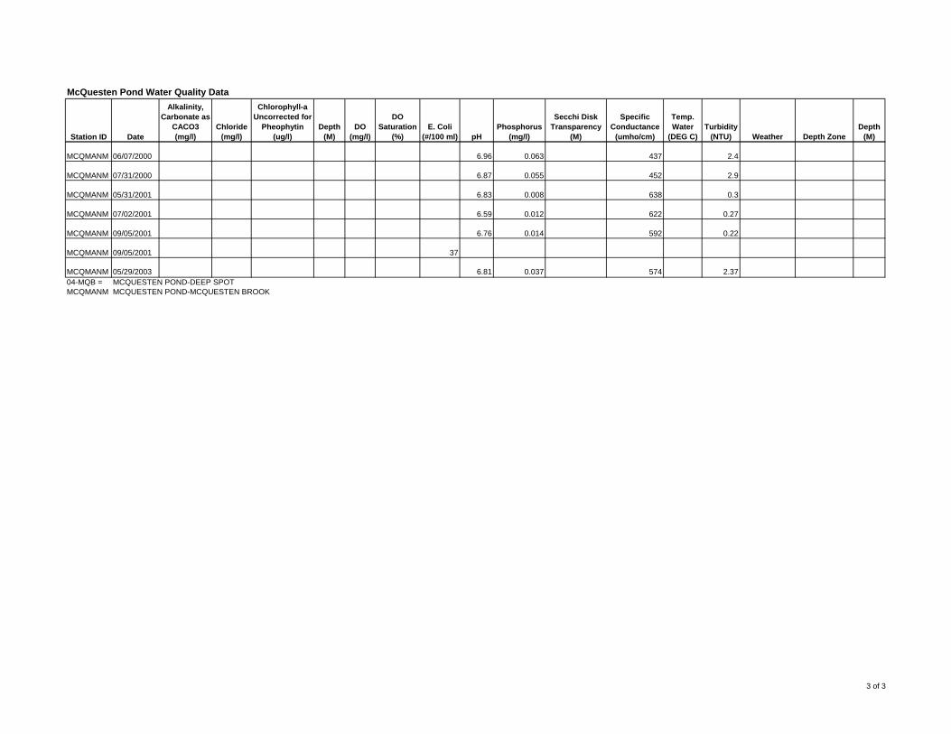
McQuesten Pond Water Quality Data
Station ID Date
Alkalinity, Carbonate as
CACO3 (mg/l)
Chloride (mg/l)
Chlorophyll-a Uncorrected for
Pheophytin (ug/l)
Depth (M)
DO (mg/l)
DO Saturation
(%)E. Coli
(#/100 ml) pH Phosphorus
(mg/l)
Secchi Disk Transparency
(M)
Specific Conductance
(umho/cm)
Temp. Water
(DEG C)Turbidity
(NTU) Weather Depth ZoneDepth
(M)
MCQMANM 06/07/2000 6.96 0.063 437 2.4
MCQMANM 07/31/2000 6.87 0.055 452 2.9
MCQMANM 05/31/2001 6.83 0.008 638 0.3
MCQMANM 07/02/2001 6.59 0.012 622 0.27
MCQMANM 09/05/2001 6.76 0.014 592 0.22
MCQMANM 09/05/2001 37
MCQMANM 05/29/2003 6.81 0.037 574 2.37 04-MQB = MCQUESTEN POND-DEEP SPOTMCQMANM MCQUESTEN POND-MCQUESTEN BROOK
3 of 3

Appendix D Peak Flows and Runoff Volumes

Design Storm Precipitation (inches)Subbasin
ID Area Weighted CN
Time of Concentration Total Total Peak Total Total Peak Total Total Peak Total Total Peak Total Total Peak Total Total Peak
Runoff Runoff Runoff Runoff Runoff Runoff Runoff Runoff Runoff Runoff Runoff Runoff Runoff Runoff Runoff Runoff Runoff Runoff(acres) (days hh:mm:ss) (inches) (cf) (cfs) (inches) (cf) (cfs) (inches) (cf) (cfs) (inches) (cf) (cfs) (inches) (cf) (cfs) (inches) (cf) (cfs)
Sub-01 9.83 92.18 0 00:04:26 1.71 61,018 17.12 2.08 74,220 20.64 3.43 122,392 32.87 4.21 150,225 39.79 4.80 171,278 44.95 5.39 192,331 50.10Sub-02 4.66 86.28 0 00:02:33 1.26 21,314 6.35 1.60 27,065 7.97 2.85 48,210 13.77 3.59 60,728 17.10 4.15 70,201 19.60 4.73 80,012 22.10Sub-03 18.61 74.93 0 00:03:10 0.65 43,910 12.61 0.89 60,123 17.73 1.89 127,678 37.96 2.53 170,912 50.46 3.02 204,014 60.08 3.53 238,467 69.83Sub-04 1.10 76.32 0 00:02:00 0.71 2,835 0.85 0.97 3,873 1.17 2.00 7,986 2.40 2.65 10,581 3.16 3.15 12,578 3.73 3.67 14,654 4.32Sub-05 2.18 93.98 0 00:02:01 1.87 14,798 4.10 2.25 17,805 4.88 3.62 28,647 7.57 4.40 34,819 9.09 5.00 39,567 10.22 5.59 44,236 11.35Sub-06 0.97 94.00 0 00:02:00 1.87 6,584 1.83 2.25 7,922 2.18 3.62 12,746 3.37 4.41 15,528 4.05 5.00 17,606 4.56 5.59 19,683 5.06Sub-07 5.76 94.12 0 00:04:05 1.88 39,309 10.80 2.27 47,463 12.84 3.63 75,899 19.94 4.42 92,417 23.95 5.01 104,753 26.95 5.61 117,298 29.93Sub-08 14.28 71.77 0 00:10:07 0.52 26,955 6.07 0.74 38,359 9.23 1.66 86,048 22.34 2.26 117,150 30.74 2.73 141,513 37.37 3.22 166,913 44.07Sub-09 5.75 76.38 0 00:13:47 0.71 14,819 3.37 0.97 20,246 4.75 2.00 41,745 10.18 2.65 55,312 13.56 3.16 65,957 16.16 3.68 76,811 18.82Sub-10 2.45 94.00 0 00:02:33 1.87 16,631 4.60 2.25 20,010 5.47 3.62 32,194 8.49 4.41 39,220 10.20 5.00 44,468 11.48 5.59 49,715 12.75Sub-11 24.81 80.32 0 00:17:43 0.91 81,955 17.90 1.20 108,072 24.03 2.32 208,940 47.49 3.01 271,082 61.53 3.54 318,813 72.37 4.09 368,347 83.20Sub-12 183.05 71.44 0 00:38:39 0.51 338,880 46.13 0.72 478,419 70.70 1.63 1,083,089 174.23 2.23 1,481,771 241.68 2.70 1,794,073 294.83 3.19 2,119,664 348.68Sub-13 285.42 70.46 0 00:49:32 0.47 486,955 56.95 0.68 704,531 88.96 1.57 1,626,637 227.96 2.15 2,227,560 319.07 2.61 2,704,155 390.96 3.09 3,201,471 463.97
Notes:1. Wetlands and water are excluded from subwatershed areas for peak runoff calculations.
10 YR - 24 HR Storm 25 YR - 24 HR Storm 50 YR - 24 HR Storm 100 YR - 24 HR Storm1 YR - 24 HR Storm 2 YR - 24 HR StormRunoff Volumes and Peak Flows
2.50 2.90 4.30 5.10 5.70 6.30

Appendix E BMP Alternatives Conceptual Drawings

4-3.
Tre
atm
ent P
ract
ices
Example Design
Bioretention

4-3.
Tre
atm
ent P
ract
ices
Example Design
Infiltration Basin

Infiltration Parking Divider

4-3.
Tre
atm
ent P
ract
ices
Example Design
Leaching Catch Basin/Dry Well

4-3.
Tre
atm
ent P
ract
ices
Example Design
Permeable Pavement

4-3.
Tre
atm
ent P
ract
ices
Example Design
Figure 4-3. Manning’s n Value with Varying Flow Depth (Source: Claytor and Schueler, 1986)
Treatment Swale

4-3.
Tre
atm
ent P
ract
ices
Example Design
Bioretention soil mix80% sand, 20% compost
Existing subgrade
Impervious surface
Cross section of72” diameter concrete vault
12” Overflow pipe
12” Perforated subdrain
12” Overflow outlet, discharges to existingstorm drain or the surface
Vegetationcentered in treatment
Native soils
Qv Conveyance protection bypass
Mound 6” bermaround tree filter rim
Crushed stone
Tree Filter

4-3.
Tre
atm
ent P
ract
ices
Example Design
Vegetated Buffer