geological reconnaissance work in the andrew lake area of
TRANSCRIPT

EUB/AGS Sciences Report 2006-02
Geological Reconnaissance Work in the Andrew Lake Area of Northeastern Alberta, NTS 74M

EUB/AGS Earth Sciences Report 2006-02
Geological Reconnaissance Work in the Andrew Lake Area of Northeastern Alberta, NTS 74M
D.I. Pană1, R.A. Olson1 and S. Byron2
1Alberta Geological Survey 2Formerly of Alberta Geological Survey
March 2006
©Her Majesty the Queen in Right of Alberta, 2006 ISBN 0-7785-1520-6
The Alberta Energy and Utilities Board/Alberta Geological Survey (EUB/AGS) and its employees and contractors make no warranty, guarantee or representation, express or implied, or assume any legal liability regarding the correctness, accuracy, completeness or reliability of this publication. Any digital data and software supplied with this publication are subject to the licence conditions (specified in 'Licence Agreement for Digital Products'). The data are supplied on the understanding that they are for the sole use of the licensee, and will not be redistributed in any form, in whole or in part, to third parties. Any references to proprietary software in the documentation, and/or any use of proprietary data formats in this release, do not constitute endorsement by the EUB/AGS of any manufacturer's product.
When using information from this publication in other publications or presentations, due acknowledgment should be given to the EUB/AGS. The following reference format is recommended:
Pană, D.I., Olson, R.A. and Byron, S. (2006): Geological reconnaissance work in the Andrew Lake area of northeastern Alberta; Alberta Energy and Utilities Board, EUB/AGS Earth Sciences Report 2006-02, 29 p.
Published March 2006 by: Alberta Energy and Utilities Board Alberta Geological Survey 4th Floor, Twin Atria Building 4999 – 98th Avenue Edmonton, Alberta T6B 2X3 Canada
Tel: (780) 422-3767 (Information Sales) Fax: (780) 422-1918 E-mail: Website: www.ags.gov.ab.ca
EUB/AGS Earth Sciences Report 2006-02 (March 2006) • ii

Contents Contents ......................................................................................................................................................iii Acknowledgments .......................................................................................................................................v Abstract.......................................................................................................................................................vi 1 Introduction............................................................................................................................................1 2 Location, Access and Physiography .....................................................................................................1 3 Previous Work in the Andrew Lake Area ...........................................................................................3 4 General Geology.....................................................................................................................................3 5 Map Units ...............................................................................................................................................4
5.1 Taltson Granitoid Gneiss Complex..................................................................................................4 5.2 The Supracrustal Complex...............................................................................................................5 5.2.1 High to Medium-Grade Metamorphic Tectonites .................................................................5 5.2.2 L ow-Grade Metamorphic Tectonites.....................................................................................6 5.3 Taltson Plutonic Rocks ....................................................................................................................7
5.3.1 Andrew Lake Granodiorite....................................................................................................8 5.3.2 Colin Lake Granite ................................................................................................................9 5.3.3 Charles Lake Granite.............................................................................................................9 5.3.4 Tresure Loch Muscovite-Bearing Granite...........................................................................10 5.3.5 Sonja Island Muscovite-Bearing Granite ............................................................................10
6 Strain.....................................................................................................................................................10 6.1 High to Low-Grade Shear Zones ...................................................................................................11 6.2 Faults..............................................................................................................................................11
7 Mineral Occurrences ...........................................................................................................................13 8 Conclusions...........................................................................................................................................18 9 References.............................................................................................................................................19 Appendix 1 – Geochemical Data..............................................................................................................22
Figures Figure 1. General geology of the Andrew Lake area with the location of samples and selected mineral
occurrences. Base map is a composite image (geotiff) produced by fusing Indian Remote Sensing (IRS) imagery with the “A Series” geological map of Andrew Lake (1953A) by McDonough et al. (2000a). Labelled red dots are sites examined and sampled for this report. Numbered black rectangles are mineral occurrences of Godfrey (1958), which have not been re-examined.................................. 2
Figure 2. Typical outcrops of supracrustal rocks in the Andrew Lake area; high-grade metamorphic conditions (in the range of 7 to 8 kilobars and 1000°C) and intense plastic deformation accompanied by material segregation preclude preservation of any original structure.............................................. 5
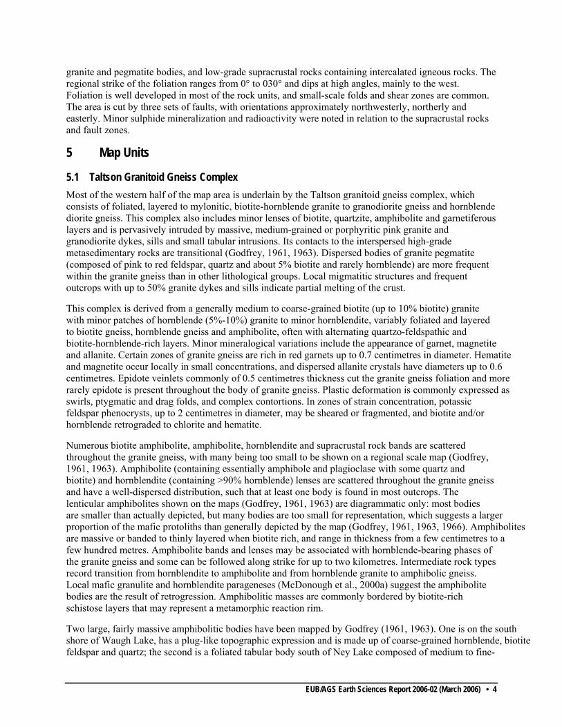
Figure 3. Typical fragmental rocks of uncertain origin in the Waugh Lake lithotectonic assemblage; a) on the divide between Doze Lake, Alberta, and Martyn Lake, Saskatchewan; b) 50 metres east of the southern end of Doze Lake. These rocks may represent either polymictic conglomerate with pebbles of quartz and granitoid gneiss, or fault rocks formed near the brittle-ductile transition of a shear zone, with undigested granitoid gneiss fragments and dismembered quartz veins. ............................. 7
Figure 4. Outcrop photographs of the Taltson plutonic rocks in the Andrew Lake area: a) vague augen textures in the foliated periphery of Andrew Lake biotite granitoid; b) megacrystic Colin Lake granitoid. .............................................................................................................................................. 8
Figure 5. Fault rocks at the southeast end of Bonny Fault, near Andrew Lake; a) quartz stockwork in brecciated granite gneiss; b) and c) typical hematite-cemented breccia with angular fragments of vein-quartz and of shattered and altered gneiss.................................................................................. 12
Figure 6. Photomicrograph of the hematitic alteration associated with brecciation and quartz veining of K-feldspar hornblende gneiss, southeast segment of Bonny Fault, Sample DP 38-2; reflected light. ... 13
EUB/AGS Earth Sciences Report 2006-02 (March 2006) • iii
Figure 7. Monazite crystal pseudomorphosed by a phosphorous-rich mesh of alteration products and Fe-oxide; sample DP 38-2. ...................................................................................................................... 14
Figure 8. Uraniferous zone southwest of Holmes Lake; a) spectrometer assay for the most ‘radioactive’ spot identified in the zone with uranium-equivalent being almost 1000 ppm; b) radioactivity readings at this spot are over 11 000 c/s; c) northwestern trench; d) northeastern trench with Holmes Lake in the background. ..................................................................................................................... 15
Figure 9. Microprobe images of samples from the uraniferous zone southwest of Holmes Lake; a) molybdenite and calcium-rich uranium oxide in a quartz vein in a retrogressed granulite, sample DP 10-E; b) zoned (Al) clinopyroxene partly replaced by chlorite on fractures, sample DP 10-I; evidence of upper granulite peak metamorphic condition attained by the supracrustal rocks in the Andrew Lake area. ............................................................................................................................ 16
EUB/AGS Earth Sciences Report 2006-02 (March 2006) • iv

Acknowledgments Paper maps 1, 2, 5 and 6 from J. Godfrey's reports (Godfrey, 1961, 1963 and 1966) have been scanned and digitized under contract by Merwin Engineering Ltd. and GISmo Solutions Ltd.
EUB/AGS Earth Sciences Report 2006-02 (March 2006) • v

Abstract A reconnaissance field program was conducted in the summer of 2005 in the Andrew Lake area. Selected geological traverses and uranium prospecting, using a sensitive GR130 spectrometer and two STRAT SPP2N scintillometers, were carried out over the main lithological units and more focused around selected radioactive sites previously identified by Godfrey (1958). Preliminary field and microscopic observations added by microprobe and fluid inclusion analyses have been integrated in the regional geological evolution of the region that includes: a) the development of the ca. 2.4-2.1 Ga Taltson biotite and hornblende granite gneiss complex, related to the tectonothermal recycling of the western Archean Churchill Province; b) a subsequent tectonothermal event in which well-layered migmatized bands of possibly supracrustal rocks were incorporated in the granitoid gneissic complex; and c) emplacement of the ca. 1.96 Ga Andrew Lake and ca 1.97 Ga Colin Lake granitoids, local representatives of the regional Taltson plutonism.
The metamorphic transformations observed in thin sections, the polyphase ductile deformation of the well-layered and migmatized rocks (routinely interpreted as bands of supracrustal rocks) and the exclusive association with the ca. 1.93 Charles Lake and the ca. 1.92 Sonja Island anatectic granitoids suggest that they represent discontinuous domains of deformation and partial melting of the Taltson granite gneiss complex. Migmatization appears to be a first phase of uranium enrichment, as many of the pegmatitic dykes and veins show radioactivity four to eight times the background level (e.g., Spider Lake). Subsequent zones of strain and fluid-flow concentration within the supracrustal units resulted in lower grade metamorphic tectonites often associates with higher concentration of uranium, sulphide, arsenide and possibly gold (e.g., the uraniferous zone southwest of Holmes Lake). The intense carbonatic metasomatism commonly associated with the Athabasca-type uranium deposits has not been observed. The hematite cemented breccia and quartz stockwork within the examined segments of Bonny Fault are apparently uranium depleted. Future exploration for uranium and base metals in the Andrew Lake area should concentrate on detailed examination of the entire belt of fault rocks that define Bonny Fault, the belts of chlorite-zone retrogression and the pegmatite units, particularly within supracrustal rocks.
EUB/AGS Earth Sciences Report 2006-02 (March 2006) • vi
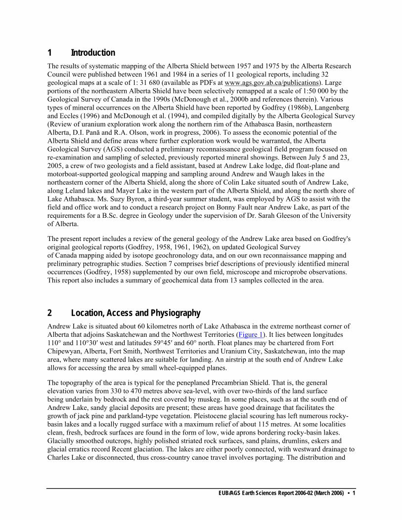
1 Introduction The results of systematic mapping of the Alberta Shield between 1957 and 1975 by the Alberta Research Council were published between 1961 and 1984 in a series of 11 geological reports, including 32 geological maps at a scale of 1: 31 680 (available as PDFs at www.ags.gov.ab.ca/publications). Large portions of the northeastern Alberta Shield have been selectively remapped at a scale of 1:50 000 by the Geological Survey of Canada in the 1990s (McDonough et al., 2000b and references therein). Various types of mineral occurrences on the Alberta Shield have been reported by Godfrey (1986b), Langenberg and Eccles (1996) and McDonough et al. (1994), and compiled digitally by the Alberta Geological Survey (Review of uranium exploration work along the northern rim of the Athabasca Basin, northeastern Alberta, D.I. Pană and R.A. Olson, work in progress, 2006). To assess the economic potential of the Alberta Shield and define areas where further exploration work would be warranted, the Alberta Geological Survey (AGS) conducted a preliminary reconnaissance geological field program focused on re-examination and sampling of selected, previously reported mineral showings. Between July 5 and 23, 2005, a crew of two geologists and a field assistant, based at Andrew Lake lodge, did float-plane and motorboat-supported geological mapping and sampling around Andrew and Waugh lakes in the northeastern corner of the Alberta Shield, along the shore of Colin Lake situated south of Andrew Lake, along Leland lakes and Mayer Lake in the western part of the Alberta Shield, and along the north shore of Lake Athabasca. Ms. Suzy Byron, a third-year summer student, was employed by AGS to assist with the field and office work and to conduct a research project on Bonny Fault near Andrew Lake, as part of the requirements for a B.Sc. degree in Geology under the supervision of Dr. Sarah Gleeson of the University of Alberta.
The present report includes a review of the general geology of the Andrew Lake area based on Godfrey's original geological reports (Godfrey, 1958, 1961, 1962), on updated Geological Survey of Canada mapping aided by isotope geochronology data, and on our own reconnaissance mapping and preliminary petrographic studies. Section 7 comprises brief descriptions of previously identified mineral occurrences (Godfrey, 1958) supplemented by our own field, microscope and microprobe observations. This report also includes a summary of geochemical data from 13 samples collected in the area.
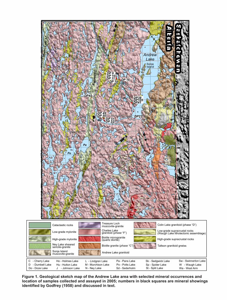
2 Location, Access and Physiography Andrew Lake is situated about 60 kilometres north of Lake Athabasca in the extreme northeast corner of Alberta that adjoins Saskatchewan and the Northwest Territories (Figure 1). It lies between longitudes 110° and 110°30′ west and latitudes 59°45′ and 60° north. Float planes may be chartered from Fort Chipewyan, Alberta, Fort Smith, Northwest Territories and Uranium City, Saskatchewan, into the map area, where many scattered lakes are suitable for landing. An airstrip at the south end of Andrew Lake allows for accessing the area by small wheel-equipped planes.
The topography of the area is typical for the peneplaned Precambrian Shield. That is, the general elevation varies from 330 to 470 metres above sea-level, with over two-thirds of the land surface being underlain by bedrock and the rest covered by muskeg. In some places, such as at the south end of Andrew Lake, sandy glacial deposits are present; these areas have good drainage that facilitates the growth of jack pine and parkland-type vegetation. Pleistocene glacial scouring has left numerous rocky-basin lakes and a locally rugged surface with a maximum relief of about 115 metres. At some localities clean, fresh, bedrock surfaces are found in the form of low, wide aprons bordering rocky-basin lakes. Glacially smoothed outcrops, highly polished striated rock surfaces, sand plains, drumlins, eskers and glacial erratics record Recent glaciation. The lakes are either poorly connected, with westward drainage to Charles Lake or disconnected, thus cross-country canoe travel involves portaging. The distribution and
EUB/AGS Earth Sciences Report 2006-02 (March 2006) • 1
SSaasskkaattcchheeww
aannAA
llbbeerrttaa
Sk - Sedgwick LakeD - Dumbell Lake
L - Lindgren LakeM - Murchison Lake
St - Split Lake
Sw - Swinnerton LakeSp - Spider Lake
C - Cherry Lake
J - Johnson Lake
Pa - Pans LakePo - Potts Lake
Sw
Sp
Wa - West ArmSd - SederholmHu - Hutton LakeHo - Holmes Lake
W - Waugh LakeDo - Doze Lake N - Ney Lake
Figure 1. Geological sketch map of the Andrew Lake area with selected mineral occurrences andlocation of samples collected and assayed in 2005; numbers in black squares are mineral showingsidentified by Godfrey (1958) and discussed in text.
Taltson granitoid gneiss
High-grade supracrustal rocks
Andrew Lake granitoid
Low-grade supracrustal rocks(Waugh Lake lithotectonic assemblage)
High-grade mylonite
Low-grade mylonite
Cataclastic rocks Colin Lake granitoid (phase “D”)
Charles Lakegranitoid (phase “F”)
Sonja Islandmuscovite-granite
Treasure Lochmuscovite-granite
Biotite microgranite(quartz diorite)
Ney Lake shearedsericite-granite Biotite granite (phase “C”)
DP 52
DP 50DP 51
DP 10
DP38DP105DP41
DP45-3
DP23
AndrewLakeSonjaIsland
Sk
L
Pa
Po
D
Ho
HuDo
Sd
W
NSp
C
J
Wa
Bay
onet
SZ
Cha
rles
Lake
SZ
BonnyFault
DP 11DP 9
DP 18 DP 16
DP 49

shapes of the lakes are structurally and lithologically-controlled, as ice erosion plucked out less resistant rocks. As a result, narrow elongate bays and straight shorelines are associated with erosion of fault zones.
3 Previous Work in the Andrew Lake Area In 1892 and 1893, J.B. Tyrrell made the initial canoe traverse along the north shore of Lake Athabasca and was followed by F.J. Alcock in 1915 and 1917 (Alcock, 1915, 1917; Tyrrell, 1896). In 1929 and 1930 Cameron and Hicks (Cameron, 1930; Cameron and Hicks, 1931; Hicks, 1930, 1932) conducted a reconnaissance survey of the Shield area north of Lake Athabasca; one of their canoe traverses began from Andrew Lake. After gold was discovered at Goldfields, the area adjoining the Andrew Lake district to the east was mapped on a scale of 1 inch to 4 miles (Alcock, 1936). North of the Alberta border, the Fort Smith map sheet, at a scale of 1 inch to 4 miles, was published by Wilson (1941). Low-grade uranium mineralization was found in the Andrew Lake area in the course of uranium prospecting and exploration during the 1950s (e.g., Ferguson, 1953), which led to a small uranium prospecting program of the Alberta Shield by the Alberta Research Council (Collins, 1954). In 1957 and 1958, J. Godfrey of the Alberta Research Council mapped the Andrew Lake area based on sub-parallel pace and compass traverses (generally spaced at 400 to 500 metres) and collected hand-specimens as standard reference samples to represent the typical lithology of each map unit. The geology and location of known mineral showings in the Andrew Lake area were first reported by Godfrey (1958, 1961, 1963). A description of the mineral occurrences in a larger area, which encompasses the Andrew Lake area, was published by Godfrey (1958), and this was followed by intense staking activity and filing of about 150 mineral claims. In 1959, the Geological Survey of Canada carried out a reconnaissance survey of the Alberta Shield and published a map at 1 inch to 4 miles scale, with marginal notes (Riley, 1960). In 1960, the Saskatchewan Department of Mineral Resources (Koster, 1961) carried out a mapping program at a scale of 1 inch to 1 mile in an area adjacent to the east of the Andrew Lake map area. The Geological Survey of Canada conducted surficial mapping of the Alberta Shield during the 1990s and published a report accompanied by a series of maps (Bednarsky, 1999). Remapping and reinterpretation of the local geology, aided by isotope dating and thermobarometric data, is included in the “A Series” map 1953A of the Geological Survey of Canada (McDonough et al., 2000), a series of journal papers (McDonough et al., 2000; Grover et al., 1997; McNicoll et al., 2000) and a Ph.D. thesis (Schetselaar, 2000). Regional geophysical data for the Alberta Shield have been published by the Geological Survey of Canada, Ottawa (1958), Sprenke et al. (1986), Charbonneau et al. (1994) and Lyatsky and Pană (2003). 4 General Geology The Andrew Lake area is part of the Taltson magmatic zone, the southern segment of the Taltson-Thelon orogen (e.g., Hoffman, 1988; Ross et al., 1991; Berman and Bostock, 1997; McDonough et al., 2000; McNicoll et al., 2000). The dominant geological feature of the Andrew Lake area is the alternation of northerly trending bands, from metres to 5 kilometres in width, made up of three principal rock groups (Godfrey 1958, 1961, 1962; McDonough et al., 2000; McNicoll et al., 2000):
• various granitoid gneiss units of the ca. 2.4-2.1 Ga Taltson basement complex,
• variably deformed porphyry feldspar biotite granitoids of the ca. 1.986 – 1.925 Ga Taltson plutonic complex, and
• a variably migmatized and retrogressed complex of supracrustal rocks. The gradational mineralogical and textural transition between many granite and granite gneiss units makes the establishment of some lithological boundaries difficult. The western part of the area is underlain mainly by the Taltson granite gneiss complex containing isolated bands and patches of high-grade supracrustal rocks and a high-grade mylonite belt; the eastern part is occupied by a series of porphyry feldspar biotite granites, massive to foliated-biotite and leucocratic
EUB/AGS Earth Sciences Report 2006-02 (March 2006) • 3
granite and pegmatite bodies, and low-grade supracrustal rocks containing intercalated igneous rocks. The regional strike of the foliation ranges from 0° to 030° and dips at high angles, mainly to the west. Foliation is well developed in most of the rock units, and small-scale folds and shear zones are common. The area is cut by three sets of faults, with orientations approximately northwesterly, northerly and easterly. Minor sulphide mineralization and radioactivity were noted in relation to the supracrustal rocks and fault zones.
5 Map Units
5.1 Taltson Granitoid Gneiss Complex Most of the western half of the map area is underlain by the Taltson granitoid gneiss complex, which consists of foliated, layered to mylonitic, biotite-hornblende granite to granodiorite gneiss and hornblende diorite gneiss. This complex also includes minor lenses of biotite, quartzite, amphibolite and garnetiferous layers and is pervasively intruded by massive, medium-grained or porphyritic pink granite and granodiorite dykes, sills and small tabular intrusions. Its contacts to the interspersed high-grade metasedimentary rocks are transitional (Godfrey, 1961, 1963). Dispersed bodies of granite pegmatite (composed of pink to red feldspar, quartz and about 5% biotite and rarely hornblende) are more frequent within the granite gneiss than in other lithological groups. Local migmatitic structures and frequent outcrops with up to 50% granite dykes and sills indicate partial melting of the crust.
This complex is derived from a generally medium to coarse-grained biotite (up to 10% biotite) granite with minor patches of hornblende (5%-10%) granite to minor hornblendite, variably foliated and layered to biotite gneiss, hornblende gneiss and amphibolite, often with alternating quartzo-feldspathic and biotite-hornblende-rich layers. Minor mineralogical variations include the appearance of garnet, magnetite and allanite. Certain zones of granite gneiss are rich in red garnets up to 0.7 centimetres in diameter. Hematite and magnetite occur locally in small concentrations, and dispersed allanite crystals have diameters up to 0.6 centimetres. Epidote veinlets commonly of 0.5 centimetres thickness cut the granite gneiss foliation and more rarely epidote is present throughout the body of granite gneiss. Plastic deformation is commonly expressed as swirls, ptygmatic and drag folds, and complex contortions. In zones of strain concentration, potassic feldspar phenocrysts, up to 2 centimetres in diameter, may be sheared or fragmented, and biotite and/or hornblende retrograded to chlorite and hematite.
Numerous biotite amphibolite, amphibolite, hornblendite and supracrustal rock bands are scattered throughout the granite gneiss, with many being too small to be shown on a regional scale map (Godfrey, 1961, 1963). Amphibolite (containing essentially amphibole and plagioclase with some quartz and biotite) and hornblendite (containing >90% hornblende) lenses are scattered throughout the granite gneiss and have a well-dispersed distribution, such that at least one body is found in most outcrops. The lenticular amphibolites shown on the maps (Godfrey, 1961, 1963) are diagrammatic only: most bodies are smaller than actually depicted, but many bodies are too small for representation, which suggests a larger proportion of the mafic protoliths than generally depicted by the map (Godfrey, 1961, 1963, 1966). Amphibolites are massive or banded to thinly layered when biotite rich, and range in thickness from a few centimetres to a few hundred metres. Amphibolite bands and lenses may be associated with hornblende-bearing phases of the granite gneiss and some can be followed along strike for up to two kilometres. Intermediate rock types record transition from hornblendite to amphibolite and from hornblende granite to amphibolic gneiss. Local mafic granulite and hornblendite parageneses (McDonough et al., 2000a) suggest the amphibolite bodies are the result of retrogression. Amphibolitic masses are commonly bordered by biotite-rich schistose layers that may represent a metamorphic reaction rim.
Two large, fairly massive amphibolitic bodies have been mapped by Godfrey (1961, 1963). One is on the south shore of Waugh Lake, has a plug-like topographic expression and is made up of coarse-grained hornblende, biotite feldspar and quartz; the second is a foliated tabular body south of Ney Lake composed of medium to fine-
EUB/AGS Earth Sciences Report 2006-02 (March 2006) • 4

grained homblende and plagioclase that includes blocks of the main phase of Colin Lake granite. Within the Colin Lake granite suite, and less commonly in the Andrew Lake granite, many small mafic bodies (not shown on the map) are altered to sheared hornblende-plagioclase-biotite-chlorite rocks (amphibolites). This suggests that at least some of the amphibolite units have a mafic intrusive precursor.
Uranium-lead zircon ages from the Taltson granitoid gneiss complex range from 2.14 to 3.1 Ga. A hornblende gneiss has yielded a U-Pb zircon age of 2380 ±10 Ma, and a syenogranite gneiss yielded a concordant U-Pb zircon age of 2138 ±1 Ma. Zircons from a biotite-rich tonalite mylonitic gneiss yielded a three-point, U-Pb upper intercept age of 3076 +15/-5 Ma, which testifies for the Archean inheritance of at least some of the Taltson granitoid gneiss units.
5.2 The Supracrustal Complex
5.2.1 High to Medium-Grade Metamorphic Tectonites Mappable bands and minor unmappable lenses of biotite (+/- pink to red garnet, alumosilicate, graphite) schist interlayered with milky quartz pods, feldspar augen gneiss, granite and pegmatite lenses or dykes, ferruginous, garnetiferous and graphitic zones are scattered throughout the granite gneiss terrain that underlies the western part of the Andrew Lake map area. A variety of garnet biotite schist and quartzite (more rarely sillimanite and tourmaline), commonly associated with migmatites (up to 50%) and intense quartz veining, make up four mappable belts in the Andrew Lake area: 1) immediately west and north of Andrew Lake, 2) south of Holmes Lakes, 3) at Spider Lake, and 4) east of Spider Lake. Minor amphibolite and basic phases were noted in some metasedimentary bodies and are particularly conspicuous toward the north end of the Spider Lake biotite schist-quartzite band.
Internal structures in these biotite schist-quartzite bands record high strain and commonly exhibit extreme contortion, crenulation and shear structures (Figure 2). These rock types have been routinely described as pelitic, semipelitic gneiss and metaquartzite, essentially based on their well developed layering and the frequent presence of alumosilicate minerals. Godfrey (1961), for example, interpreted the layering, particularly the interlayering of quartzite and biotite-sericite schist and the colour-banding in quartzite to represent transposed primary sedimentary bedding, but he conceded that “no evidence of graded bedding, crossbedding, minor erosion surfaces, and similar features was found” (Godfrey, 1961, p. 12). In his next report, the biotite schist in high-grade metasedimentary rocks is described “with primary sedimentary
Figure 2. Typical outcrops of supracrustal rocks in the Andrew Lake area; high-grade metamorphic conditions (in the range of 7 to 8 kilobars and 1000°C) and intense plastic deformation accompanied by material segregation preclude preservation of any original structure.
EUB/AGS Earth Sciences Report 2006-02 (March 2006) • 5
features being absent” (Godfrey, 1963, p. 12). In this report, the generic term ‘supracrustal rocks’ is preferred, allowing for a more comprehensive connotation that includes both rocks derived through prograde metamorphism of sediments (no unequivocal evidence documented so far) and rocks derived through retrograde metamorphism and migmatization of the lower tonalite-granulite-charnockitic crust (in the view of the senior author, there is overwhelming evidence for this origin).
Common mineral assemblages in these gneiss units include biotite-garnet-sillimanite±cordierite± andalusite±graphite that are variably retrogressed to an association of chloritized biotite-sericite schist and phyllonite, which are invariably interlayered with quartzite. It is noteworthy that most of the mapped metaquartzite units, which range in thickness from less than 1 metre to over 10 metres, are in fact banded siliceous mylonite bounded by sheared quartzo-feldspatic rocks, with flaser and mortar mylonitic texture (Godfrey, 1961). Minor shear zones are locally marked by hematite and pyrite, and highlighted by weathering as gossans and rusty zones. Ortho to feldspathic-quartzite (with the latter including biotite, sericite, chlorite and, rarely, garnet and hematite, such as near Lindgren and Sedgwick lakes; Godfrey, 1961) are typically sugary textured, medium grained and with colour banding that ranges in thickness from millimetres to 0.6 metres. Concordant or discordant granite or pegmatite dykes, lenses, pods or stringers typically form a contorted migmatite complex. Migmatite structures are more commonly found at contacts of the supracrustal rocks with the enclosing granitoid gneiss and include tight isoclinal or chevron folds, drag folds and other more complicated forms indicative of plastic flow. Quartz veins, lenses and pods are found in the schists, and to a lesser degree in the adjacent quartzite layers.
All contacts between supracrustal rock bands and granite gneiss are concordant (that is, the foliation and gneissosity on both sides of the contact are parallel) and gradational either as shear contacts or through a migmatic mixed-rock zone. The magmatic gradational contact consists of a 10-metre to 100 metre-wide zone of contorted migmatites. Feldspar augen, pegmatites, migmatitic phases and small granite bodies are especially abundant in the Spider Lake biotite schist-quartzite band. In the shear contacts, bands of granite gneiss and metasedimentary rock alternate in a zone up to 170 metres (e.g., near southwest corner of Andrew Lake) with various degrees of shearing that range to a true faulted contact. The gradational transition from granite gneiss to supracrustal rocks is best illustrated by the contact of metasedimentary rocks with the sheared periphery of the Andrew Lake biotite granite. There, within a 100 to 170 metres wide transition zone, the proportion of feldspar augen in the sheared Andrew Lake granite decreases at the expense of biotite and quartz that are the dominant components of the supracrustal rocks. The contact zone commonly consists of contorted, mixed rock types, where lenses and pods of one rock type are interfingered with another. The main Andrew Lake supracrustal band at the northern end of Andrew Lake contains appreciable amounts of small masses of augen feldspar and biotite granites that are sliced off parts of Andrew Lake granitoid.
Geothermobarometric calculations for the area under consideration indicate peak metamorphic conditions of approximately 5 to 7 kilobars and 800°C (Grover et al., 1997). However, the correlative Rutledge River supracrustal gneiss units of the northern Taltson magmatic zone have certainly experienced upper granulite facies metamorphic conditions with temperatures of 920-1045°C and pressures of ca. 7 kilobars (Berman and Bostock, 1997).
5.2.2 Low-Grade Metamorphic Tectonites In the area of Doze-Waugh lakes, near the Alberta/Saskatchewan border, a distinct complex of biotite-rich quartzitic schist, phyllonite, minor milky quartzite pods, locally abundant quartz veins and dismembered quartz veins in a phyllonitic matrix, with ferruginous, garnetiferous, graphitic zones and minor pegmatite has been described as the Waugh Lake Group (Figure 1). It also includes medium to coarse-grained chlorite and biotite-rich mafic schist and fine-grained, intermediate to mafic igneous rocks that have been interpreted as volcanic rocks deformed at greenschist to sub-greenschist grade (Godfrey, 1963).
EUB/AGS Earth Sciences Report 2006-02 (March 2006) • 6
Figure 3. Typical fragmental rocks of uncertain origin in the Waugh Lake lithotectonic assemblage; a) on the divide between Doze Lake, Alberta, and Martyn Lake, Saskatchewan; b) 50 metres east of the southern end of Doze Lake. These rocks may represent either polymictic conglomerate with pebbles of quartz and granitoid gneiss, or fault rocks with granitoid gneiss fragments and dismembered quartz veins, formed near the brittle-ductile transition within a shear zone.
At least one layer of metaconglomerate was mapped between Doze Lake, Alberta, and Martyn Lake, Saskatchewan (Figure 3) (Langenberg et al., 1995). In Godfrey’s opinion “large fragments and pebbles may be of clastic origin, but cataclastic deformation of a granitic phase, such as porphyroblastic biotite granites A and B [i.e., Andrew Lake granitoid], could also give rise to crush conglomerates and to a sericitic, porphyro-clastic phyllonite” (Godfrey, 1963, p. 11).
Farther south along strike on either side of Ney Lake, Godfrey (1963) distinguished a sheared leucocratic muscovite-bearing granite (Figure 1). The Ney Lake granite is of uniform mineralogical and textural character with muscovite, less biotite, medium to fine-grained white to pink feldspar generally aligned in the foliation plane marked by sericite. Small shears are commonly parallel to the foliation. The sheared leucocratic granite includes domains of poorly defined, small, irregular bodies and lenses of massive biotite and muscovite granites. Contacts with the porphyric massive biotite granite are generally gradational. Contacts with the main phase of Colin Lake (biotite granite “D” of Godfrey, 1963) are sharp, concordant and well defined by the contrast in texture (Godfrey, 1963). A muscovite-bearing granite of similar appearance has been described on the west side of Hills Island Lake, N.W.T., as the ca. 1.934 Ga Natael granite related to anatectic processes along the Tazin shear zone (Bostock and van Breemen, 1994).
The Waugh Lake lithotectonic assemblage reportedly continues to the north, into the Tazin belt of low-grade metamorphic rocks described in the Northwest Territories by Bostock (1992) and to the southeast in Saskatchewan, into the belt of low-grade rocks mapped as the “western metasedimentary and metavolcanic complex” by Kostner (1961). The tectonic significance of this 0.5 to 1.5 kilometres wide by 150 kilometres long, vertical belt of low-grade metamorphic rocks, in the light of petrographical, geochemical and geochronological data will be discussed in The Tazin-Waugh Lake Zone of Strain at the Eastern Margin of the Taltson Magmatic Zone (D. I. Pană et al., Geological Survey of Canada, Current Research, work in progress).
5.3 Taltson Plutonic Rocks The particular element of the Taltson Magmatic Zone situated at the western margin of Churchill Province is represented by the intrusion of the ca. 1.986 to 1.925 Ga voluminous granitoid plutons. In the Andrew Lake area, this magmatic event is represented by the Andrew Lake and Colin Lake granitoids and by minor anatectic granitoidic intrusions spatially associated with major belts of mylonites
EUB/AGS Earth Sciences Report 2006-02 (March 2006) • 7

(Charles Lake megacrystic granite and Treasure Loch muscovite-bearing granite) or belts of supracrustal rocks (Sonja Island muscovite-bearing granite).
5.3.1 Andrew Lake Granodiorite Two plutons of Andrew Lake biotite-hornblende granodiorite, which consist of 30% to 40%, equant phenocrysts 2.5 centimetres, in a medium to coarse-grained matrix of biotite, hornblende and feldspar, have previously been mapped: one, west of Andrew Lake and another north of Bonny Fault, from Murchison Lake into Northwest Territories.
The core of the plutons is relatively massive to poorly foliated biotite granite that corresponds to “biotite granite B” of Godfrey (1961) and may include a more feldspathic and massive grey granite phase. The peripheries of the plutons are foliated, with generally euhedral, 1 to 2.5 centimetres K-feldspar megacrysts, set in a feldspar-biotite-quartz-minor hornblende foliated matrix (Figure 4a), which corresponds to “biotite granite A” of Godfrey (1961). The feldspar megacrysts may have red rims, and some show simple twinning. In addition to the white porphyric feldspars, small (<0.5 centimetres diameter) red feldspars may be present in the groundmass. Local shear zones are marked by discrete segregations of schistose biotite-rich lenses commonly a few centimetres wide and several metres in length with feldspar porphyroblasts or clasts. Occasional mylonitic zones, up to half a metre wide, appear as hard, siliceous, grey to green bands. The strained peripheries of the Andrew Lake plutons grade into high strain rocks mapped as belts of supracrustal rocks (described above), and are invariably intruded by 1 centimetre to over 3 metres width slightly discordant pegmatite, microgranite and aplite bodies, which make up to 10% of the total rock (compared to 1% in the core of the plutons). Development of foliation postdates or is synchronous with emplacement of much of the composite aplite-pegmatite masses. Toward the contact with the Waugh Lake schists, the Andrew Lake granite shows a clear strain gradient from euhedral, tabular megacrysts in the relatively undeformed granite through biotite-rich zones where the porphyroblastic feldspars are typically fractured and elongated in the direction of shear, to an augen-flow texture where small red feldspars (0.3 centimetres) form near the contact.
U-Pb zircon analyses of two samples from the Andrew Lake granitoid indicate emplacement ages of 1959±3 Ma and 1962 +16/-10 Ma (McDonough et al., 2000b).
Figure 4. Outcrop photographs of the Taltson plutonic rocks in the Andrew Lake area: a) vague augen textures in the foliated periphery of Andrew Lake biotite granitoid; b) megacrystic Colin Lake granitoid.
EUB/AGS Earth Sciences Report 2006-02 (March 2006) • 8

5.3.2 Colin Lake Granite Granite types “C”, “D” and “biotite microgranite” that were separated by Godfrey (1961, 1963) southeast of Andrew Lake, have been interpreted as different phases of the Colin Lake granitic batholith by McDonough et al. (2000a).
Biotite microgranite, restricted to the area near Waugh Lake, has a higher percentage of total mafic constituents than the porphyry varieties and has up to 0.4 centimetres augens of white to grey feldspars in a well-foliated biotite matrix. Generally fairly uniform, it includes minor aplite and grades to porphyroblastic biotite granite “C” or to amphibolite. The north side of the biotite microgranite body west of Waugh Lake has an inter-tonguing contact with low-grade biotite schist of the Waugh Lake assemblage; over a distance of 400 metres along strike, as the contact with Waugh Lake schist is approached, the biotite microgranite becomes finer-grained, more biotite-rich, more sheared and passes along strike into quartz-sericite-chlorite phyllonite. A sample from this body described as massive to moderately foliated quartz diorite, yielded an age of 1.971±4 Ma and was interpreted as intrusive in the Waugh Lake Group (McDonough et al., 2000a). To the south, it grades into biotite granite with abundant white to pink porphyry feldspar up to 0.8 centimetres.
Porphyry feldspar biotite granite “C” is found only at the southern end of the Waugh Lake supracrustalband, principally between Johnson and Cherry lakes in the southeastern section of the map area, although small masses are also present in the adjoining rock units. It is fine to medium-grained with feldspar porphyroblasts/clasts up to 1.2 centimetres, has an obvious biotite foliation, accompanied by a common alignment of porphyroblastic feldspars. Biotite granite “C” is intruded by massive granite and pegmatite bodies. The regional foliation overprints these intrusive contacts, but is cut by dykes and veins of granite with more K-feldspar and less biotite. These relationships are similar to those noted in the sheared periphery of the Andrew Lake granitoid, where granite gneiss appears also to be cut by leucocratic granite, pegmatite and aplite dykes. Hence, the regional foliation developed after the emplacement of the Andrew and Colin granitoid plutons, and was accompanied by granite veining and migmatization.
Both porphyroblastic biotite granite “C” and “biotite microgranite” are interlayered with and are transitional along strike into the Waugh Lake highly sheared low-grade rocks. North of Johnson Lake slightly sheared biotite granite “C” encloses a 2.5 by 12 metre lens of impure quartzite.
Biotite granite “D” exists south of Johnson Lake and occurs as small patches in the adjacent biotite granite “C” to the west. This is the main phase of the Colin Lake granite, which is well developed in the Colin Lake area and consists of moderately to well foliated, K-feldspar megacrystic biotite granite gneiss with feldspar crystals in a medium- to coarse-grained matrix of biotite, and minor hornblende (Figure 4b). The abundance of feldspar phenocrysts increases from 2% at the contact with adjacent granitoids up to 30% to 50% a few tens of metres away (Godfrey, 1963).
The foliation is northerly striking and typically well expressed by coarse-grained biotite and lenticular quartz matrix with commonly aligned feldspar porphyroblasts/clasts.
5.3.3 Charles Lake Granite A series of sub-kilometre size bodies of massive to foliated megacrystic granite are spatially associated with the Charles Lake and Bayonet Lake high-grade mylonite belts and their peripheries of supracrustal rocks. In the area under consideration, there exist only a few small bodies that parallel the Bayonet Fault and correspond to granite “F” of Godfrey and Langenberg (1988). Charles Lake granite consists of 15% to 30% K-feldspar megacrysts in a medium-grained, biotite-rich matrix. Megacrysts have distinctive
EUB/AGS Earth Sciences Report 2006-02 (March 2006) • 9

biotite inclusions. This granitoid has been variably deformed in the Charles Lake shear zone to amphibolite- to greenschist-grade protomylonite to mylonite.
Preliminary U-Pb zircon and monazite analyses suggest an emplacement age of ca. 1933 Ma (McDonough et al., 2000b).
5.3.4 Treasure Loch Muscovite-Bearing Granite Spatially associated with the Charles Lake porphyry granite and the Charles Lake shear zone is a white to light grey to pink, muscovite-bearing, pegmatitic, coarse grained to megacrystic granite; it also contains rare biotite. This granite is weakly to nonfoliated and thus it may represent one of the late to post-kinematic muscovite-bearing anatectic granites commonly associated with long-lived shear zones in the Taltson magmatic zone.
5.3.5 Sonja Island Muscovite-Bearing Granite A distinctive muscovite-bearing granite phase forms sub-kilometre size intrusions, mainly within the wide belt of medium-grade supracrustal rocks that occur along the axis of Andrew Lake (e.g., they are well represented on Sonja Island) and within the adjacent strained periphery of the Andrew Lake granitoid (e.g., near Sederholm Lake) to the west (Figure 1). This granitoid extends southwards toward Johnson Lake into various granite phases assigned to the Colin Lake pluton, which led McDonough et al. (2000a) to consider the muscovite-bearing granite a late phase of the Colin Lake pluton. The Sonja Island granite is leucocratic,with up to 15% muscovite, with feldspar and quartz, partly as graphic intergrowths, medium to coarse-grained, and locally grades to muscovite pegmatite (with very little garnet). It is also cut by lenses and dykes of pink granite, muscovite pegmatite and feldspar pegmatite that range in width from 1.5 to 15 metres and are particularly abundant around Sederholm Lake and near Andrew Lake; as noted previously, these pegmatites tend to be associated with the contact between the biotite granite gneiss and bands of supracrustal rocks.
The muscovite-bearing granite bodies intrude and crosscut ductile shear fabrics and are weakly foliated. These granites are likely late to post kinematic relative to the ductile strain recorded by the belts of supracrustal rocks and have been emplaced independently of the Colin Lake pluton. U-Pb zircon and monazite analyses suggest a best estimate emplacement age of ca. 1.923 Ga, with monazite crystallization as late as 1.913 Ga (McDonough et al., 2000b).
6 Strain The regional structural trend is northerly, parallel to the foliation, which is steep and generally dips to the west. Regional folds have not been identified in the map area; instead, all major rock types show some degree of shear with local concentration in mylonite belts. With respect to outcrop scale folds, the structural pattern of the Taltson granite gneiss complex is in marked contrast with that of the porphyry feldspar biotite granites. Thus, in the Taltson granite gneiss complex, outcrop-scale sheath, isoclinal and drag folds, contorted and crenulated structures are indicative of multiple phases of intense plastic deformation. Similarly, the supracrustal inclusions show drag folds, crenulations and mullions. In contrast, very little folding is evident on any scale within the porphyry biotite granite and the massive biotite granite and pegmatite units. The foliation is well developed in all lithological groups. Thus, in the supracrustal rocks, alternation of centimetre to metre wide layers of differing rock types has produced a characteristic banded appearance parallel to the foliation. The Taltson granite gneiss complex is typically layered, but includes domains of homogeneous, massive texture. Similarly, the Andrew Lake biotite granite shows good foliation, mainly along the peripheries, defined by parallelism of biotite and minor hornblende and porphyroblastic feldspar, which is much diminished in the inclusions of more massive grey granite phases. Muscovite granite and muscovite pegmatite are fairly massive except where locally affected by
EUB/AGS Earth Sciences Report 2006-02 (March 2006) • 10
shear zones with foliation marked by mortar, flaser or mylonitic texture or just lenses of newly formed biotite schist.
Mineral lineation, mullion and rod structures are rare except in the supracrustal rocks. Boudinaged amphibolite structures are characteristic of the granite gneiss where plastic flow has deformed many of the boudins into lenses, pods and other related forms, and the enclosing well-banded granite gneiss exhibits extreme contortion.
6.1 High to Low-Grade Shear Zones In the western part of the area under consideration, a high-grade mylonite belt defines the Bayonet Lake shear zone. It consists of well banded, quartzo-feldspathic mylonite, protomylonite and ultramylonite overprinting the Taltson granitoid gneiss complex. Where well exposed, the mylonite belt shows gradational margins toward the wallrock. Sparsely preserved, subhorizontal quartz stretching lineation, amphibolite pull-aparts, and ductilely deformed feldspars, including sigma K-feldspar porphyroclast are all indicative of granulite to upper amphibolite facies metamorphic conditions during mostly sinistral shearing (McDonough et al., 2000b). The high-grade mylonite belt, as well as other domains of the Taltson granitoid gneiss complex and its supracrustal inclusions and of Taltson plutons, is variably overprinted by lower grade mylonite. Amphibolite to greenschist-grade mylonite includes well foliated, light coloured mylonite to protomylonite with abundant sigma-type porphyroclasts. Augen (porphyroclastic) textures are especially well developed on Andrew Lake biotite granite. The augen-feldspar grains are fractured, and gradually lose their euhedral form to become cataclastically rounded. Under conditions of extensive shear the augen structure grades to mortar or flaser structure, with rounded, coarse grains packed in a fine-grained ‘raisin structure’ mylonitic matrix. Mylonite belts, mainly in the Andrew Lake granitoid, are associated with epidote stringers, which typically are millimetre wide and a few metres long, and groups of anastomosing stringers that may extend for tens of metres along strike.
6.2 Faults Major faults either trend northwesterly, and thus transect the strike of the mainly northerly regional structural trend, or they trend northerly parallel to the regional strike. The most notable fault to transect the regional structural trend is Bonny Fault (Godfrey, 1958b). Its trace suggests a subvertical fault with an azimuth of approx 120° that extends southeasterly from the Alberta-NWT border passing under Sedgwick, Murchison, Holmes and Split Lakes into Andrew Lake. At Split Lakes, Bonny Fault branches out east-southeasterly. The termination and lack of obvious fit of the different lithological units on each side of the fault suggest that it accommodated substantial sinistral displacement. Chlorite, red feldspar and mylonite are common features within the wallrock adjacent to the fault, and hematitized, silicified breccias are present at intervals in the southeast section of the fault. Highly fractured gneiss with randomized fabric (little or no planar fabric and no linear fabric), hematite cemented breccia and cataclasite, typically weathers as a rust colour (Figure 5 and 6). The Bonny Fault trace commonly is marked by up to 15 metres of breccia, chloritized, silicified, feldspathized and phyllonitic fault rocks. Bands of mylonite and vertical shear fractures, which strike from 023° to 035° and areas with prominent chlorite and red feldspar, are characteristic features of this structurally disturbed zone. On the south shore of Murchison Lake a ramifying network of quartz veins is laced through a zone of breccia and chloritized, feldspathized mylonite that is at least 14 metres wide (Godfrey, 1961). Another fault at the northeast shore of Andrew Lake (Figure 1 ), is steeply dipping to the southwest, is sub-parallel to the Bonny fault in that it trends southeasterly at about 140°, is marked by a scarp in the Andrew Lake batholith and controls the shape of the shoreline for almost 2 kilometres. Small-scale features associated with this fault include mylonite and shear-fractures with chloritization and albitization, but hematitized quartz-cemented and quartz-veined breccia are notably absent (Godfrey, 1961). Northwest of Andrew
EUB/AGS Earth Sciences Report 2006-02 (March 2006) • 11

Lake the projected fault line disappears under an area of muskeg and water and is then traced in granite gneiss to the northern provincial boundary.
Figure 5. Fault rocks at the southeast end of Bonny Fault, near Andrew Lake; a) quartz stockwork in brecciated granite gneiss; b) and c) typical hematite-cemented breccia with angular fragments of vein-quartz and of shattered and altered gneiss.
EUB/AGS Earth Sciences Report 2006-02 (March 2006) • 12
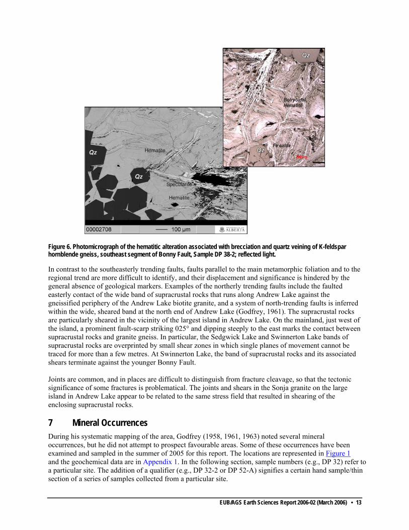
Figure 6. Photomicrograph of the hematitic alteration associated with brecciation and quartz veining of K-feldspar hornblende gneiss, southeast segment of Bonny Fault, Sample DP 38-2; reflected light.
In contrast to the southeasterly trending faults, faults parallel to the main metamorphic foliation and to the regional trend are more difficult to identify, and their displacement and significance is hindered by the general absence of geological markers. Examples of the northerly trending faults include the faulted easterly contact of the wide band of supracrustal rocks that runs along Andrew Lake against the gneissified periphery of the Andrew Lake biotite granite, and a system of north-trending faults is inferred within the wide, sheared band at the north end of Andrew Lake (Godfrey, 1961). The supracrustal rocks are particularly sheared in the vicinity of the largest island in Andrew Lake. On the mainland, just west of the island, a prominent fault-scarp striking 025° and dipping steeply to the east marks the contact between supracrustal rocks and granite gneiss. In particular, the Sedgwick Lake and Swinnerton Lake bands of supracrustal rocks are overprinted by small shear zones in which single planes of movement cannot be traced for more than a few metres. At Swinnerton Lake, the band of supracrustal rocks and its associated shears terminate against the younger Bonny Fault. Joints are common, and in places are difficult to distinguish from fracture cleavage, so that the tectonic significance of some fractures is problematical. The joints and shears in the Sonja granite on the large island in Andrew Lake appear to be related to the same stress field that resulted in shearing of the enclosing supracrustal rocks. 7 Mineral Occurrences During his systematic mapping of the area, Godfrey (1958, 1961, 1963) noted several mineral occurrences, but he did not attempt to prospect favourable areas. Some of these occurrences have been examined and sampled in the summer of 2005 for this report. The locations are represented in Figure 1 and the geochemical data are in Appendix 1. In the following section, sample numbers (e.g., DP 32) refer toa particular site. The addition of a qualifier (e.g., DP 32-2 or DP 52-A) signifies a certain hand sample/thinsection of a series of samples collected from a particular site.
EUB/AGS Earth Sciences Report 2006-02 (March 2006) • 13

Figure 7. Monazite crystal pseudomorphosed by a phosphorous-rich mesh of alteration products and Fe-oxide; sample DP 38-2.
Particular attention has been given to selected mineral occurrences along Bonny Fault, where Godfrey (1958, 1961) suggested that brecciation and shearing associated with hematitization, feldspathization and chloritization have the typical appearance of uraniferous zones in the Beaverlodge district of Saskatchewan, some 70 kilometres to the east. A number of anomalous radioactive spots (Godfrey’s "Location 4") have been re-examined and sampled for this report. The southeastern segment of Bonny Fault is marked by a topographic low between Hutton and Andrew lakes, where a spectacular quartz stockwork, hematite cemented breccia with granite gneiss and vein-quartz fragments, are locally exposed (Figure 5 and 6). The wallrock consists mainly of pink granitoid gneiss and pegmatite of the Taltson granitoid gneiss complex. The alteration of pyroxene to amphibole, biotite to chlorite, plagioclase to clay minerals accompanied by silicification, veinlets of prehnite (DP 16), interkinematic growth of quartz, chlorite, sphene, epidote and sericite (DP 18), can be related to an increase in brittle strain toward Bonny Fault. Scintillometer traverses indicate very low radioactivity is produced by the hematitic breccia; the highest radioactivity, up to five times the background, occurs in spotty locales in less tectonized granite gneiss wallrock and undigested pods within the fault. Geochemical data from three samples of anomalously radioactive K-feldspar hornblende gneiss from this segment of the Bonny Fault have returned intriguing results. For example, a sample from a K-feldspar hornblende granitoid with a radioactivity of 900 c/s (five times the background, using the 130GR spectrometer) shows a high barium value (2017 ppm) and a uranium concentration of 24.6 ppm (DP 105). In contrast, two other samples from the same rock type, but from highly tectonized and strongly hematitic zones (DP 38 and DP 41), returned remarkably depleted barium (38 ppm and 105 ppm, respectively) and low uranium (<3 ppm) concentrations (Appendix 1). These preliminary data suggest that the granitoid has released barium and uranium during brecciation, water percolation and hematitization within Bonny Fault. Petrography and microprobe work appear to support the idea of uranium extraction during alteration of uraniferous minerals (Figure 7). Preliminary fluid inclusions work indicate that fluids percolating Bonny Fault were highly saline (~30 wt% NaCl equivalent) and at temperatures between 81°C and 138° (possibly 181°C) (Byron, 2006), similar to temperatures of mineralizing fluids in the Beaverlodge and Wollaston uraniferous districts.
EUB/AGS Earth Sciences Report 2006-02 (March 2006) • 14
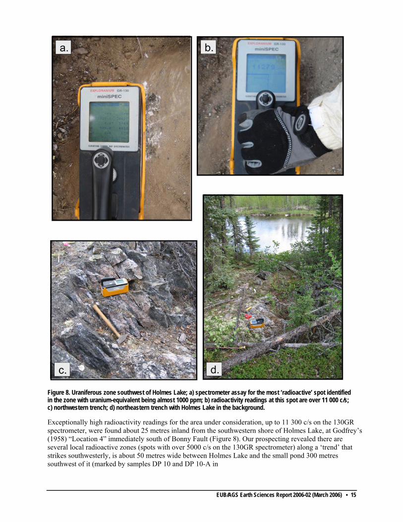
Figure 8. Uraniferous zone southwest of Holmes Lake; a) spectrometer assay for the most ‘radioactive’ spot identified in the zone with uranium-equivalent being almost 1000 ppm; b) radioactivity readings at this spot are over 11 000 c/s; c) northwestern trench; d) northeastern trench with Holmes Lake in the background.
Exceptionally high radioactivity readings for the area under consideration, up to 11 300 c/s on the 130GR spectrometer, were found about 25 metres inland from the southwestern shore of Holmes Lake, at Godfrey’s (1958) “Location 4” immediately south of Bonny Fault (Figure 8). Our prospecting revealed there are several local radioactive zones (spots with over 5000 c/s on the 130GR spectrometer) along a ‘trend’ that strikes southwesterly, is about 50 metres wide between Holmes Lake and the small pond 300 metres southwest of it (marked by samples DP 10 and DP 10-A in
EUB/AGS Earth Sciences Report 2006-02 (March 2006) • 15

Figure 1). In this same zone, there are three old, partly overgrown trenches with each excavated up to a few metres perpendicular to the local southwesterly structural trend (two of the trenches are within 20 metres from the southwest shore of Holmes Lake and a third one is approximately 150 metres inland along strike); these trenches testify to the prior exploration interest this radioactive locale had, which presumably was sparked by Godfrey’s (1958) discovery. Intriguingly, samples DP 10 and in particular DP 10-A, from the most ‘radioactive’ outcrop on which the 130GR spectrometer gave a U-equivalent assay of almost 1000 ppm uranium (Figure 8), geochemical assays show lesser concentrations of U (395 ppm), plus Th (210 ppm) and Pb (215 ppm) (Appendix 1). As well, there are slightly elevated Mo, V and Zn concentrations, minor amounts of S (0.12%-0.15%) and low, but perhaps slightly elevated, concentrations of arsenic (11-12 ppm) and Au (16 ppb). It is possible these anomalous metal concentrations may indicate this zone has resulted from prior local hydrothermal activity (Appendix 1). Finally, uranium oxides and molybdenite have been microscopically identified in a number of thin sections from this location (Figure 9a). According to existing maps, the hostrocks are part of a 1 by 6 kilometres band of high-grade supracrustal rocks. Our field and microscope observations of this well-layered succession show there are spectacular ductile deformation, variable degrees of mylonitization and local overprinting by a discrete subvertical cleavage. The dominant rock types are biotite schist and biotite pegmatite (DP 10-E), plagioclasic (anorthositic ?) pegmatite (DP 10-I) with gabbro-diorite (DP 11) and amphibolite (PD 9) lenses. In thin section, the mineral assemblage in the mafic rock includes clinopyroxene (almost completely
amphibolitized), primary amphibole, intermediate to basic plagioclase and minor amounts of quartz and magnetite. Microprobe analyses revealed aluminum zonation in clinopyroxene (i.e., lower Al in cores versus higher Al in the rims; Figure 9b) similar to the mafic granulites in the northern portion of the Taltson magmatic zone, where near peak metamorphic conditions of at least 7 kilobars and 1045°C have been documented (Berman and Bostock, 1997). The amphibolite shows a lens of quartz in which feldspar inclusions have simultaneous extinction, which suggests metasomatic substitution of a feldspathic space by quartz. Chlorite and sulphide grains in quartz may be related to low-grade metasomatism/metallogenesis. Preliminary work on wafers prepared from sample DP 10-E, consisting of 95% sheared anhedral quartz and 5% iron oxide with minor molybdenite, uranium oxide/hydroxide and clays, indicates the presence of two types of fluid inclusions. Most inclusions are small and exhibit a ‘trail distribution’ pattern, which suggests the
EUB/AGS Earth Sciences Report 2006-02 (March 2006) • 16
inclusions are of secondary origin. The few larger, likely of primary origin, fluid inclusions yielded homogenization temperatures between 150°C and 250°C (possibly up to 350°C) (Byron, 2006). Homogenization temperatures higher than 200°C have been reported from uranium deposits in Beaverlodge district of Saskatchewan (Sassano et al., 1972); hence, this may indicate portions of Bonny Fault zone and adjacent wallrock are favourable for Beaverlodge-style vein-type uranium deposits. A couple of small, sub-metre zones of limonitic weathering (gossan) have been sampled in an attempt to confirm the previously reported molybdenite occurrence at Godfrey’s (1958) "Location 12" on the north shore of the West Arm of Andrew Lake (Location DP 50, Figure 1). The outcrop consists of biotite-cordierite-garnet gneiss locally with incipient augen texture. The poikiloblastic garnet and polysynthetically twinned cordierite porphyroblasts formed during partial melting of a plagioclase-quartz-biotite gneiss (DP 50-2). Subsequent low-grade alteration of the rock resulted in sericite-chlorite pseudomorphs after cordierite. In adjacent rocks to the east (DP 49-1) along a contact between pegmatite and gneiss, thin sections show the strained and recrystallized pegmatite vein consists of microcline, antiperthite, quartz, chloritized biotite and altered aluminosilicate-kyanite (?) and the gneiss is a plagioclase-biotite-kyanite (?) gneiss with prehnite and K-feldspar veinlets. If confirmed, the kyanite would be the first identification of the high pressure-low temperature Al2SiO5 polymorph in the southern Taltson magmatic zone. A microcline-oligoclase-biotite-muscovite-andalusite (pseudomorphous after an unidentifiable mineral) granitoid gneiss, from the same spot (DP 49), contains an undeformed gabbroic xenolith consisting of clinopyroxene (slightly amphibolitized), plagioclase, biotite and minor quartz. To the south across the western arm, three more samples were collected from a garnet-cordierite-plagioclase gneiss with static growth of muscovite (DP 52-A), a garnet-cordierite-K-feldspar gneiss (DP 52-B) and a garnet-sillimanite-K-feldspar gneiss (DP 52-C) with partial melting restite of corroded red biotite and microperthitic K-feldspar. Partial re-equilibration to low-grade conditions resulted in the alteration of sillimanite to sericite and of biotite to chlorite. The textures observed in thin sections from these outcrops and from those in the uraniferous zone (Godfrey’s, 1958, "Location 4"), which include clinopyroxene, locally altered to amphibole, indicate upper granulite facies metamorphic conditions, partial melting (corroded red biotite of a metagranite and gabbro xenolith) accompanied by deformation of foliated protoliths (trails of relict minerals in poikiloblastic garnet), decompression through the sillimanite and andalusite stability fields and late alteration at very shallow structural levels (sericite and zeolite blastesis). The metamorphic history of these rocks is certainly more complex than simple prograde metamorphism of sediments. They may have formed as discontinuous, more or less linear, domains of partial melting of the Taltson crust at lower to middle crust levels, triggered by fluid influx within zones of strain, and then gradually uplifted to shallower structural levels.
Geochemical analyses of samples DP 50-1 and DP 50-2 from the rusty zones on the north shore of the West Arm of Andrew Lake do not show any noticeable metallic element concentration and Mo values are barely above the detection limit of 2 ppm (Appendix 1). Samples DP 52-A, B and C from the southern shore show slightly elevated values of Cr, Ni, V and Zr (Appendix 1). The pegmatite sample (DP 51) yielded much depleted values of U (0.8 ppm) and Th (2 ppm) compared to the associated gneiss (3 to 4 ppm U and 13 to 36 ppm Th).
A concordant metamorphic segregation of quartz cut by secondary quartz veins was sampled at the Bayonet Lake high-grade mylonite belt for Au (sample DP 45-3) and a pegmatite from the southwestern corner of Andrew Lake (DP 23) was sampled for rare-earth elements. No anomalous concentrations of metals were found and the values of U and Th are very small (Appendix 1).
About 700 m southwest of the elbow of the Western Arm of Andrew Lake, Godfrey’s (1958) “Location 1” could not be reached during the summer of 2005 (Figure 1). This site is described as consisting of vertical layers of quartzite, biotite schist, feldspathic quartzite, porphyroblastic feldspar schist and pegmatite that record high strain. An iron stained band, 15 centimetres by 35 metres, in biotite
EUB/AGS Earth Sciences Report 2006-02 (March 2006) • 17

schist with lenses, pods and veins of quartz was reported to contain pyrite, molybdenite and yellow uranium stain (carnotite ?) associated with anomalous radioactivity more than six times the background. Godfrey (1958) reported three assayed grab samples from the radioactive zone yielded relatively high concentrations of U3O8 and molybdenite, partly confirmed for two of his three samples by semi-quantitative spectrographic analysis (numbers in parentheses): 1.03 (1.0), 3.29 and 3.93 (2.5) per cent U3O8 and 0.69 (1), 1.03 and 1.40 (2) per cent MoO. Godfrey’s (1958) “Location 2” at Spider Lake consists of an 800 metres (inferred to possibly extend over 3.6 kilometres) long zone of strain marked by biotite schist, garnetiferous and feldspathic quartzite with molybdenite, yellow uranium stain (carnotite ?) and anomalous radioactive occurrences (3 to 5 times the background) associated with variably strained pink feldspar pegmatite (Figure 1). Slightly radioactive pegmatite bodies, up to four times the background, have been identified north and west of Cherry Lake, and a feldspathic garnetiferous quartzite along a northerly trending vertical zone of shearing north of Cherry Lake has been reported to produce anomalous radioactivity seven to eight times above background (“Location 3d” of Godfrey, 1958) (Figure 1). Small gossan and rusty zones parallel to the rock strike are commonly found in metasedimentary rock bands and are particularly evident in the Lindgren-Sedgwick lakes area. Pyritization is a common feature of most metasedimentary rock bands, and some other sulphides, such as arsenopyrite, smaltite and pyrrhotite, were identified at several points in the metasedimentary band at Lindgren-Sedgwick lakes. Quartzite and biotite schist on the southwest shore of Lindgren Lake have sulphide minerals within a gossan from which samples yielded small amounts of Ni, Ag and Au (Godfrey’s 1958 “Location 5”). The distribution of the mineral showings within the high-grade supracrustal rocks indicates that the sulphide occurrences (pyrite, arsenopyrite, smaltite, pyrrhotite) are confined to high-strain zones (e.g., in the Lindgren-Sedgwick lakes band or in the Spider Lake band) and faults. In the Waugh Lake low-grade rocks, small amounts of arsenopyrite, pyrrhotite, galena, molybdenite and chalcopyrite have been reported by (Godfrey, 1958, 1963). Unique to this band is the extensive presence of tourmaline-quartz composite veins which are concentrated on the north shore of the elbow of Waugh Lake. A sample from one of these composite tourmaline-quartz-arsenopyrite veins in the metasedimentary rocks located just east of the fourth meridian north of Waugh Lake, yielded small amounts of Au, Ag and Ni (Godfrey, 1958). 8 Conclusions The AGS reconnaissance field program in the Andrew Lake area consisted of selected traverses over the main lithological units, re-examination of some of the radioactive sites previously identified by Godfrey (1958) using the more sensitive GR130 spectrometer, and a preliminary petrographic study aided by microprobe and fluid inclusion analyses conducted by Ms. S. Byron for her B.Sc. studies. The geological evolution of the region includes a) the development of the ca. 2.4-2.1 Ga Taltson biotite and hornblende granite gneiss complex, related to the tectonothermal recycling of the western Archean Churchill Province; b) a subsequent tectonothermal event in which well-layered migmatized bands of possibly supracrustal rocks were incorporated in the granitoid gneissic complex; and c) the emplacement of the ca. 1.97 Ga Colin Lake granitoids and ca. 1.96 Ga Andrew Lake, which are the local representatives of the major Talton plutonism documented to have taken place regionally between ca. 1.986 and 1.925 Ga.
The metamorphic transformation observed in thin sections, the polyphase ductile deformation of the well-layered and migmatized rocks routinely interpreted as bands of metasediments (supracrustal rocks) should
EUB/AGS Earth Sciences Report 2006-02 (March 2006) • 18

be considered cautiously. These domains of strain concentration were intruded by the ca. 1.93 Ga Charles Lake and the ca. 1.92 Ga Sonja Island anatectic granitoids. Migmatization appears to be a first phase of uranium enrichment as many of the pegmatitic dykes and veins show radioactivity four to eight times the background level (e.g., at Spider Lake). Subsequent zones of strain and fluid-flow concentration within the supracrustal bands resulted in lower grade metamorphic tectonites often associated with higher concentration of uranium, sulphide, arsenide and possibly gold (e.g., the uraniferous zone southwest of Holmes Lake). Anomalous radioactivity of several times background was found at a number of places adjacent to the main Bonny Fault zone, rather than being within the fault trace itself, particularly where bands of biotite-bearing gneiss and schist mapped as metasedimentary rocks abut against the fault. The southerly trending anomalously radioactivity zone (with radioactive ‘spots’ that locally produce from 5000 c/s up to 11 000 c/s) immediately south of Holmes Lake, includes uranium oxide in association with carbonate and warrants further exploration. Godfrey’s (1958) "Location 1" with the best uranium concentrations reported so far (ranging up to 3.29% U3O8) deserves re-examination. However, the intense carbonatic metasomatism, which is typical for the Beaverlodge and Athabasca vein type uraniferous zones, has not been observed yet in the Andrew Lake area. The apparent uranium depletion in the hematite cemented breccia and quartz stockwork within the examined segments of Bonny Fault suggests that active vertical hydrodynamic cells, responsible for the extensive rock alteration, may have effectively removed uranium. In the absence of a sedimentary cover (as in the case of Athabasca unconformity-related uranium deposits), the only possible traps for mineralizing fluids are the relatively porous domains of shearing and chlorite zone retrogression in adjacent belts of supracrustal rocks. Future exploration for uranium and base metals in the Andrew Lake area should concentrate on the belts of supracrustal rocks mainly within zones of strain and fluid flow concentration marked by chlorite-zone retrogression. Additionally, small grade uranium targets are pegmatite units, particularly within the belts of supracrustal rocks. 9 References Alcock, F. J. (1915): Geology of the north shore of Lake Athabasca, Alberta and Saskatchewan;
Geological Survey of Canada, Summary Report 1914, p. 60-61.
Alcock, F. J. (1917): Black Bay and Beaverlodge Lake areas, Saskatchewan; Geological Survey of Canada, Summary Report 1916, p. 152-156.
Alcock, F. J. (1936): Geology of Lake Athabasca region, Saskatchewan; Geological Survey of Canada, Memoir 196, 41 p.
Baadsgaard, H. and Godfrey, J.D. (1972): Geochronology of the Canadian Shield in northeastern Alberta II, Charles-Andrew-Colin Lakes Area; Canadian Journal of Earth Sciences, v. 9, p. 863-881.
Berman, R.G. and Bostock, H.H. (1997) Metamorphism in the northern Taltson magmatic zone, Northwest Territories; Canadian Mineralogist, v. 35, p. 1069-1091.
Bernadsky, J.M. (1999): Quaternary geology of northeastern Alberta; Geological Survey of Canada, Bulletin 535, 29 p.
Burwash, R. A. (1958): Age of the Alberta Precambrian basement; Alberta Society of Petroleum Geologists, v. 6, no. 9, p. 214-217.
Cameron, A. E. (1930): Report of progress on mineral explorations in the Precambrian; Scientific and Industrial Research Council of Alberta, Tenth Annual Report, p. 34-39.
Cameron, A. E. and Hicks, H. S. (1931): The Precambrian area of northeastern Alberta; Research Council of Alberta, Eleventh Annual Report, p. 32-40.
Chacko, T., De, K.S., Creaser, R.A. and Muehlenbachs, K. (2000): Tectonic setting of the Taltson magmatic zone at 1.9-2.0 Ga: a granitoid-based perspective; Canadian Journal of Earth Science, v. 37, p. 1597-1609.
EUB/AGS Earth Sciences Report 2006-02 (March 2006) • 19

Charbonneau, B W, Holman, P B and Hetu, R J. (1994): Levé géophysique aéroporté, northeast Alberta/Airborne geophysical survey, northeast Alberta; Geological Survey of Canada, Open File 2807, 13 maps, scale 1:250 000.
Collins, G. A. and Swan, A. G. (1954): Preliminary report of geological field work, northeastern Alberta; Research Council of Alberta, Information Series 18, 8 p.
Ferguson, A. B. (1953): First Alberta uranium discovery; Western Miner Oil Review, v. 26, p. 43.
Geological Survey of Canada (1964): Colin Lake, aeromagnetic map NTS 74M/9, scale 1:63 360.
Geological Survey of Canada (1964): Andrew Lake, aeromagnetic map, NTS 74M/16, scale 1:63 360.
Godfrey, J.D. (1958): Mineralization in the Andrew, Waugh and Johnson Lakes area, northeastern Alberta; Research Council of Alberta, Preliminary Report 58-4, 17 p.
Godfrey, J.D. (1961): Geology of the Andrew Lake, north district, Alberta; Research Council of Alberta, Preliminary Report 58-3, 32 p.
Godfrey, J.D. (1963): Geology of the Andrew Lake, south district, Alberta; Research Council of Alberta, Preliminary Report 61-2, 30 p.
Godfrey, J.D. (1966): Geology of the Bayonet, Ashton, Potts and Charles Lake districts, Alberta; Research Council of Alberta, Preliminary Report 65-6, 45 p.
Godfrey, J.D. (1986a): Geology of the Precambrian Shield in northeastern Alberta (NTS 74M and 74L N½); map, scale 1: 250 000.
Godfrey, J.D. (1986b): Mineral showings of the Precambrian Shield in northeastern Alberta (NTS 74M and 74L N½); map, scale 1: 250 000.
Goff, S.P., Godfrey, J.D. and Holland, J.G. (1986): Petrology and geochemistry of the Canadian Shield of northeastern Alberta; Alberta Research Council, Alberta Geological Survey, Bulletin 51, 60 p.
Grover, T.W., Pattison, D.R.M., McDonough, M.R. and McNicoll, V. (1997): Tectonometamorphic evolution of the southern Taltson magmatic zone and associated shear zones, northeastern Alberta; Canadian Mineralogist, v. 35, p. 1051-1067.
Hicks, H. S. (1930): A petrographic study of Precambrian rocks in northeastern Alberta; M.Sc. thesis, University of Alberta, 47 p.
Hicks, H. S. (1932): The geology of the Fitzgerald and northern portion of the Chipewyan map areas, northern Alberta, Canada; Ph. D. thesis, University of Minnesota, 82 p.
Koster, F. (1961): The geology of the Thainka Lake area (west half), Saskatchewan; Department of Mineral Resources, Mines Branch, Geological Division, Report 61, 28 p.
Langenberg, C.W., Iannelli, T.R. and Eccles, D.R. (1995): Revised geology and mineral occurrences of the Aphebian Waugh Lake Group, northeastern Alberta, Alberta Research Council, Alberta Geological Survey, Open File Report 1995-05, 52 p.
Langenberg, C.W. and Eccles, D.R. (1996): Metallic mineral occurrences of the exposed Precambrian Shield in northeastern Alberta, Alberta Energy and Utilities Board, EUB/AGS Bulletin 64, 71 p.
Lyatsky, H.V. and Pană, D.I. (2003): Catalogue of selected regional gravity and magnetic maps of northern Alberta; Alberta Energy and Utilities Board, EUB/AGS Special Report 56, 40 p.
McDonough, M.R. and McNicoll, V.J. (1997): U-Pb age constraints on the timing of deposition of Waugh Lake and Burntwood (Athabasca) groups, southern Taltson magmatic zone, northeastern
EUB/AGS Earth Sciences Report 2006-02 (March 2006) • 20
Alberta, in radiogenic age and isotopic studies: report 10; Geological Survey of Canada, Current Research 1997-F, p. 101-111.
McDonough, M.R., McNicoll, V.J. and Grover, T.W. (1994): Whole rock major and trace element analyses of selected mineral occurrences, Taltson magmatic zone, Canadian Shield, northeastern Alberta (NTS 74M and 74L); Geological Survey of Canada, Open File 2893, 5 p.
McDonough, M.R., Grover, T.W., McNicoll, V.J., Lindsay, D.D., Kelly, K.L., Guerstein, P.G., Bednarski, J. (2000a): Geology, Andrew Lake, Alberta-Saskatchewan-Northwest Territories; Geological Survey of Canada, "A" Series Map , no. 1953A, scale 1:50 000.
McDonough, M.R., McNicoll, V.J., Schetselaar, E.M. and Grover, T.W. (2000b): Geochronological and kinematic constraints on crustal shortening and escape in a two-sided oblique-slip collisional and magmatic orogen, Paleoproterozoic Taltson magmatic zone, northeastern Alberta; Canadian Journal of Earth Sciences, v. 37/11, p. 1549-1573.
McNicoll, V.J., Thériault, R.J. and McDonough, M.R. (2000): Taltson basement gneissic rocks: U-Pb and Nd isotopic constraints on the basement to the Paleoproterozoic Taltson magmatic zone, northeastern Alberta; Canadian Journal of Earth Sciences, v. 37/11, p. 1575-1596.
Nielsen, P.A., Langenberg, C.W., Baadsgaard, H. and Godfrey, J.D. (1981): Precambrian metamorphic conditions and crustal evolution, northeastern Alberta, Canada; Precambrian Research, v. 16, p. 171-193.
Pană, D., Creaser, R.A., Muehlenbachs, K. and Wheatley, K. (2006a): Basement geology in the Alberta portion of the Athabasca Basin, context for the Maybelle River area; in EXTECH IV: Geology and Uranium EXploration TECHnology of the Proterozoic Athabasca Basin, Saskatchewan and Alberta, (ed.) C.W. Jefferson and G. Delaney; Geological Survey of Canada, Bulletin 588 (also Saskatchewan Geological Society, Special Publication 17; Geological Association of Canada, Mineral Deposits Division, Special Publication 4).
Riley, G. C. (1960): Geology, Fort Fitzgerald, West of Fourth Meridian, Alberta; Geological Survey of Canada, Map 12-1960, scale 1: 253 440.
Ross, G.M., Parrish, R.R., Villeneuve, M.E. and Bowring, S.A. (1991): Geophysics and geochronology of the crystalline basement of the Alberta Basin, Western Canada; Canadian Journal of Earth Sciences, v. 28, p. 512–522.
Sassano, G.P., Fritz, P. and Morton, R.D. (1972): Paragenesis and isotopic composition of some gangue minerals from the uranium deposits of Eldorado, Saskatchewan; Canadian Journal of Earth Sciences, v. 9, p. 141-157.
Schetselaar, E. (2000): Integrated analysis of granite-gneiss terrain from field and multisource remotely sensed data: a case study from the Canadian Shield; Ph.D. thesis, University of Delft, 267 p.
Sprenke, K.F., Wavra, C.S. and Godfrey, J.D. (1986): The geophysical expression of the Canadian Shield of northeastern Alberta; Alberta Research Council, Bulletin 52, 54 p.
Tyrrell, J. B. (1896): Report on country between Athabasca Lake and Churchill River, N.W.T.; Geological Survey of Canada, Annual Report, v. VIII, pt. D, 1895, 117 p.
Watanabe, R.Y. (1961): Geology of the Waugh Lake metasedimentary complex, northeastern Alberta; M.Sc. thesis, University of Alberta, 90 p.
Wilson, J. T. (1941): Fort Smith, District of Mackenzie; Geological Survey of Canada, Map 607A, scale 1: 253 440.
EUB/AGS Earth Sciences Report 2006-02 (March 2006) • 21
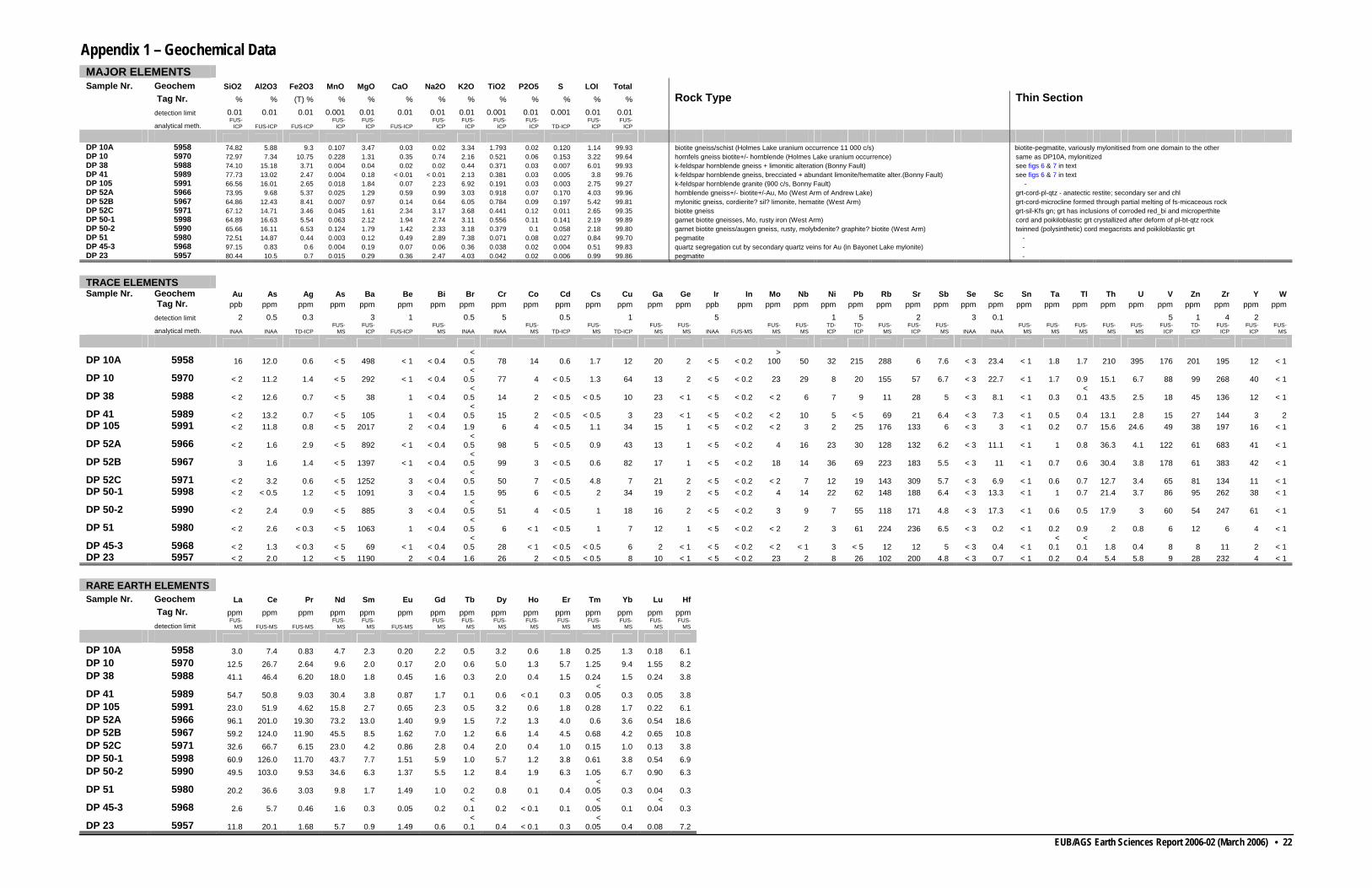
EUB/AGS Earth Sciences Report 2006-02 (March 2006) • 22
Appendix 1 – Geochemical Data MAJOR ELEMENTS
Sample Nr. Geochem SiO2 Al2O3 Fe2O3 MnO MgO CaO Na2O K2O TiO2 P2O5 S LOI Total Tag Nr. % % (T) % % % % % % % % % % % Rock Type Thin Section detection limit 0.01 0.01 0.01 0.001 0.01 0.01 0.01 0.01 0.001 0.01 0.001 0.01 0.01 analytical meth.
FUS-ICP FUS-ICP FUS-ICP
FUS-ICP
FUS-ICP FUS-ICP
FUS-ICP
FUS-ICP
FUS-ICP
FUS-ICP TD-ICP
FUS-ICP
FUS-ICP
DP 10A 5958 74.82 5.88 9.3 0.107 3.47 0.03 0.02 3.34 1.793 0.02 0.120 1.14 99.93 biotite gneiss/schist (Holmes Lake uranium occurrence 11 000 c/s) biotite-pegmatite, variously mylonitised from one domain to the other DP 10 5970 72.97 7.34 10.75 0.228 1.31 0.35 0.74 2.16 0.521 0.06 0.153 3.22 99.64 hornfels gneiss biotite+/- hornblende (Holmes Lake uranium occurrence) same as DP10A, mylonitized DP 38 5988 74.10 15.18 3.71 0.004 0.04 0.02 0.02 0.44 0.371 0.03 0.007 6.01 99.93 k-feldspar hornblende gneiss + limonitic alteration (Bonny Fault) see figs 6 & 7 in text DP 41 5989 77.73 13.02 2.47 0.004 0.18 < 0.01 < 0.01 2.13 0.381 0.03 0.005 3.8 99.76 k-feldspar hornblende gneiss, brecciated + abundant limonite/hematite alter.(Bonny Fault) see figs 6 & 7 in text DP 105 5991 66.56 16.01 2.65 0.018 1.84 0.07 2.23 6.92 0.191 0.03 0.003 2.75 99.27 k-feldspar hornblende granite (900 c/s, Bonny Fault) - DP 52A 5966 73.95 9.68 5.37 0.025 1.29 0.59 0.99 3.03 0.918 0.07 0.170 4.03 99.96 hornblende gneiss+/- biotite+/-Au, Mo (West Arm of Andrew Lake) grt-cord-pl-qtz - anatectic restite; secondary ser and chl DP 52B 5967 64.86 12.43 8.41 0.007 0.97 0.14 0.64 6.05 0.784 0.09 0.197 5.42 99.81 mylonitic gneiss, cordierite? sil? limonite, hematite (West Arm) grt-cord-microcline formed through partial melting of fs-micaceous rock DP 52C 5971 67.12 14.71 3.46 0.045 1.61 2.34 3.17 3.68 0.441 0.12 0.011 2.65 99.35 biotite gneiss grt-sil-Kfs gn; grt has inclusions of corroded red_bi and microperthite DP 50-1 5998 64.89 16.63 5.54 0.063 2.12 1.94 2.74 3.11 0.556 0.11 0.141 2.19 99.89 garnet biotite gneisses, Mo, rusty iron (West Arm) cord and poikiloblastic grt crystallized after deform of pl-bt-qtz rock DP 50-2 5990 65.66 16.11 6.53 0.124 1.79 1.42 2.33 3.18 0.379 0.1 0.058 2.18 99.80 garnet biotite gneiss/augen gneiss, rusty, molybdenite? graphite? biotite (West Arm) twinned (polysinthetic) cord megacrists and poikiloblastic grt DP 51 5980 72.51 14.87 0.44 0.003 0.12 0.49 2.89 7.38 0.071 0.08 0.027 0.84 99.70 pegmatite - DP 45-3 5968 97.15 0.83 0.6 0.004 0.19 0.07 0.06 0.36 0.038 0.02 0.004 0.51 99.83 quartz segregation cut by secondary quartz veins for Au (in Bayonet Lake mylonite) - DP 23 5957 80.44 10.5 0.7 0.015 0.29 0.36 2.47 4.03 0.042 0.02 0.006 0.99 99.86 pegmatite -
TRACE ELEMENTS
Sample Nr. Geochem Au As Ag As Ba Be Bi Br Cr Co Cd Cs Cu Ga Ge Ir In Mo Nb Ni Pb Rb Sr Sb Se Sc Sn Ta Tl Th U V Zn Zr Y W Tag Nr. ppb ppm ppm ppm ppm ppm ppm ppm ppm ppm ppm ppm ppm ppm ppm ppb ppm ppm ppm ppm ppm ppm ppm ppm ppm ppm ppm ppm ppm ppm ppm ppm ppm ppm ppm ppm detection limit 2 0.5 0.3 3 1 0.5 5 0.5 1 5 1 5 2 3 0.1 5 1 4 2
analytical meth. INAA INAA TD-ICPFUS-
MS FUS-
ICP FUS-ICPFUS-
MS INAA INAAFUS-
MS TD-ICPFUS-
MS TD-ICPFUS-
MS FUS-
MS INAA FUS-MSFUS-
MS FUS-
MS TD-ICP
TD-ICP
FUS-MS
FUS-ICP
FUS-MS INAA INAA
FUS-MS
FUS-MS
FUS-MS
FUS-MS
FUS-MS
FUS-ICP
TD-ICP
FUS-ICP
FUS-ICP
FUS-MS
DP 10A 5958 16 12.0 0.6 < 5 498 < 1 < 0.4 <
0.5
78 14 0.6 1.7 12 20 2 < 5 < 0.2>
100 50 32 215 288 6 7.6 < 3 23.4 < 1 1.8 1.7 210 395 176 201 195 12 < 1
DP 10 5970 < 2 11.2 1.4 < 5 292 < 1 < 0.4 <
0.5 77 4 < 0.5 1.3 64 13 2 < 5 < 0.2 23 29 8 20 155 57 6.7 < 3 22.7 < 1 1.7 0.9 15.1 6.7 88 99 268 40 < 1
DP 38 5988 < 2 12.6 0.7 < 5 38 1 < 0.4 <
0.5 14 2 < 0.5 < 0.5 10 23 < 1 < 5 < 0.2 < 2 6 7 9 11 28 5 < 3 8.1 < 1 0.3 <
0.1 43.5 2.5 18 45 136 12 < 1
DP 41 5989 < 2 13.2 0.7 < 5 105 1 < 0.4 <
0.5 15 2 < 0.5 < 0.5 3 23 < 1 < 5 < 0.2 < 2 10 5 < 5 69 21 6.4 < 3 7.3 < 1 0.5 0.4 13.1 2.8 15 27 144 3 2DP 105 5991 < 2 11.8 0.8 < 5 2017 2 < 0.4 1.9 6 4 < 0.5 1.1 34 15 1 < 5 < 0.2 < 2 3 2 25 176 133 6 < 3 3 < 1 0.2 0.7 15.6 24.6 49 38 197 16 < 1
DP 52A 5966 < 2 1.6 2.9 < 5 892 < 1 < 0.4 <
0.5 98 5 < 0.5 0.9 43 13 1 < 5 < 0.2 4 16 23 30 128 132 6.2 < 3 11.1 < 1 1 0.8 36.3 4.1 122 61 683 41 < 1
DP 52B 5967 3 1.6 1.4 < 5 1397 < 1 < 0.4 <
0.5 99 3 < 0.5 0.6 82 17 1 < 5 < 0.2 18 14 36 69 223 183 5.5 < 3 11 < 1 0.7 0.6 30.4 3.8 178 61 383 42 < 1
DP 52C 5971 < 2 3.2 0.6 < 5 1252 3 < 0.4 <
0.5 50 7 < 0.5 4.8 7 21 2 < 5 < 0.2 < 2 7 12 19 143 309 5.7 < 3 6.9 < 1 0.6 0.7 12.7 3.4 65 81 134 11 < 1DP 50-1 5998 < 2 < 0.5 1.2 < 5 1091 3 < 0.4 1.5 95 6 < 0.5 2 34 19 2 < 5 < 0.2 4 14 22 62 148 188 6.4 < 3 13.3 < 1 1 0.7 21.4 3.7 86 95 262 38 < 1
DP 50-2 5990 < 2 2.4 0.9 < 5 885 3 < 0.4 <
0.5 51 4 < 0.5 1 18 16 2 < 5 < 0.2 3 9 7 55 118 171 4.8 < 3 17.3 < 1 0.6 0.5 17.9 3 60 54 247 61 < 1
DP 51 5980 < 2 2.6 < 0.3 < 5 1063 1 < 0.4 <
0.5 6 < 1 < 0.5 1 7 12 1 < 5 < 0.2 < 2 2 3 61 224 236 6.5 < 3 0.2 < 1 0.2 0.9 2 0.8 6 12 6 4 < 1
DP 45-3 5968 < 2 1.3 < 0.3 < 5 69 < 1 < 0.4 <
0.5 28 < 1 < 0.5 < 0.5 6 2 < 1 < 5 < 0.2 < 2 < 1 3 < 5 12 12 5 < 3 0.4 < 1 <
0.1 <
0.1 1.8 0.4 8 8 11 2 < 1DP 23
5957 < 2
2.0
1.2
< 5
1190
2 < 0.4
1.6
26
2 < 0.5
< 0.5
8 10
< 1
< 5
< 0.2
23
2
8
26
102
200
4.8
< 3
0.7
< 1
0.2
0.4
5.4
5.8
9
28
232
4
< 1
RARE EARTH ELEMENTS
Sample Nr. Geochem La Ce Pr Nd Sm Eu Gd Tb Dy Ho Er Tm Yb Lu Hf Tag Nr. ppm ppm ppm ppm ppm ppm ppm ppm ppm ppm ppm ppm ppm ppm ppm detection limit
FUS-MS FUS-MS FUS-MS
FUS-MS
FUS-MS FUS-MS
FUS-MS
FUS-MS
FUS-MS
FUS-MS
FUS-MS
FUS-MS
FUS-MS
FUS-MS
FUS-MS
DP 10A 5958 3.0 7.4 0.83 4.7 2.3 0.20 2.2 0.5 3.2 0.6 1.8 0.25 1.3 0.18 6.1DP 10 5970 12.5 26.7 2.64 9.6 2.0 0.17 2.0 0.6 5.0 1.3 5.7 1.25 9.4 1.55 8.2DP 38 5988 41.1 46.4 6.20 18.0 1.8 0.45 1.6 0.3 2.0 0.4 1.5 0.24 1.5 0.24 3.8
DP 41 5989 54.7 50.8 9.03 30.4 3.8 0.87 1.7 0.1 0.6 < 0.1 0.3<
0.05 0.3 0.05 3.8 DP 105 5991 23.0 51.9 4.62 15.8 2.7 0.65 2.3 0.5 3.2 0.6 1.8 0.28 1.7 0.22 6.1DP 52A 5966 96.1 201.0 19.30 73.2 13.0 1.40 9.9 1.5 7.2 1.3 4.0 0.6 3.6 0.54 18.6 DP 52B 5967 59.2 124.0 11.90 45.5 8.5 1.62 7.0 1.2 6.6 1.4 4.5 0.68 4.2 0.65 10.8DP 52C 5971 32.6 66.7 6.15 23.0 4.2 0.86 2.8 0.4 2.0 0.4 1.0 0.15 1.0 0.13 3.8DP 50-1 5998 60.9 126.0 11.70 43.7 7.7 1.51 5.9 1.0 5.7 1.2 3.8 0.61 3.8 0.54 6.9DP 50-2 5990 49.5 103.0 9.53 34.6 6.3 1.37 5.5 1.2 8.4 1.9 6.3 1.05 6.7 0.90 6.3
DP 51 5980 20.2 36.6 3.03 9.8 1.7 1.49 1.0 0.2 0.8 0.1 0.4<
0.05 0.3 0.04 0.3
DP 45-3 5968 2.6 5.7 0.46 1.6 0.3 0.05 0.2<
0.1 0.2 < 0.1 0.1<
0.05 0.1<
0.04 0.3
DP 23 5957 11.8 20.1 1.68 5.7 0.9 1.49 0.6<
0.1 0.4 < 0.1 0.3<
0.05 0.4 0.08 7.2